Article

Riverbed Clogging and Sustainability of Riverbank Filtration

Division of Water Sciences, Faculty of Civil Engineering & Architecture, University of Applied Sciences Dresden, 01069 Dresden, Germany
*
Author to whom correspondence should be addressed.
Water 2016, 8(12), 604; https://doi.org/10.3390/w8120604
Submission received: 25 October 2016 / Revised: 28 November 2016 / Accepted: 15 December 2016 / Published: 20 December 2016
(This article belongs to the Special Issue Water Quality Considerations for Managed Aquifer Recharge Systems)

Abstract

:
Clogging refers to a reduction of riverbed hydraulic conductivity. Due to difficulties in determining the thickness of the clogging layer, the leakage coefficient (L) is introduced and used to quantify the recoverable portion of bank filtrate. L was determined at several riverbank filtration (RBF) sites in field tests and using an analytical solution. Results were compared with data from similar experiments in the early 1970s and 1991–1993. In the 1980s, severe river water pollution in conjunction with high water abstraction led to partly unsaturated conditions beneath the riverbed. A leakage coefficient L of 5 × 10⁻⁷ s−1 was determined. After water quality improvement, L increased to 1–1.5 × 10⁻⁶ s−1. An alternative, cost and time efficient method is presented to estimate accurate leakage coefficients. The analytical solution is based on groundwater level monitoring data from observation wells next to the river, which can later feed into numerical models. The analytical approach was able to reflect long-term changes as well as seasonal variations. Recommendations for its application are given based on experience.

1. Introduction

A very important aspect of the sustainability of riverbank filtration (RBF) is the effect of riverbed clogging. Clogging is referred to as the reduction of riverbed permeability and the result of the infiltration and accumulation of both organic and inorganic suspended solids, precipitation of carbonates, iron- and manganese-(hydr)oxides and biological processes. The recoverable amount of bank filtrate (BF) strongly depends on the infiltration resistance of the riverbed and the technically viable drawdown of the adjacent pumping wells. The infiltration resistance controls the head loss between the river and the adjacent aquifer and thus the recoverable ratio of BF as well as potential groundwater cross-flow from the other side of the river. Clogging is inevitable and can significantly decrease the specific well capacity. It is controlled by the river hydrology, the surface water quality, the well location with respect to discharge and distance from the riverbank as well as the characteristics of the riverbed [1,2]. Four types of clogging are known [3,4] and the name is given in accordance with its formation properties: physical (deposition, filtration of suspended solids), mechanical (gas entrapment), biological (bacterial growth) and chemical (precipitation reaction). The clogging process can be further specified, according its appearance, as external or internal clogging.
In order to determine the head loss caused by vertical flow through the riverbed at a given infiltration velocity, the thickness of the clogging layer is needed for computation. Due to difficulties in determining the thickness of the clogging layer, the leakage coefficient L (s−1) has been introduced, which is defined in Equation (1) as vertical hydraulic conductivity kc of the clogging layer (m/s) divided by the thickness dc of the clogging layer (m). The leakage coefficient is the reciprocal of the infiltration resistance w (s), which is commonly used in Germany.
L = k c d c = v i Δ h = 1 w
So far, no technical solutions are available for the direct determination of L. Experience shows that grain size distribution (sieving curve) analysis of riverbed sediment samples (Beyer, Hazen) yields excessively high hydraulic conductivities. Undisturbed sediment sampling in rivers with high flow velocities and water depths of >1 m is very elaborate and many samples are required.
The aim of the paper is to present and evaluate the application of an analytical approach to determine the leakage coefficient based on water level measurements in the river and between the river and the abstraction well(s). Additionally, the sustainability of RBF with concern to clogging will be discussed for a RBF site at the Elbe River in Germany.

2. Materials and Methods

2.1. Field Site Description

2.1.1. Elbe River

The Elbe River is a transnational perennial river and federal waterway that originates in the Czech Republic and flows northwest through Germany into the North Sea. Riverbed clogging was investigated at several RBF sites at the cities of Torgau, Meissen and Dresden along the upper Elbe River in the state of Saxony. The climate is humid continental with warm summers. The Elbe’s discharge varies considerably with the amount of precipitation and thawing. Mean discharge in Dresden (55.6 km downstream of the Czech Border) is 332 m3/s (at 184 cm river stage) and varies between 110 (75 cm) and 1.700 m3/s (547 cm) during mean low and high flow periods [5]. The Elbe’s width ranges in Dresden between 110 and 130 m and mean flow velocity is 1 m/s (1.6 m/s at 1.500 m3/s) [6]. Figure 1 shows the duration curve for the Elbe River stage (1994 to 2013) and exemplary seasonal flow variations during the latest clogging studies conducted in Dresden for extreme low-flow conditions (2015) and normal conditions with an extreme summer flood (2013). Please note that the river stage of zero is not the elevation of the river bottom.

2.1.2. Elbe River Water Quality

The annual median for dissolved organic carbon (DOC) concentration varied from 4.6 to 5.6 mg/L between 2000 and 2010. Specific ultraviolet absorbance (SUVA) at 254 nm wavelength was 2.5–3.1 L/(mg∙m). Mean turbidity of the Elbe River was 12 NTU and varied greatly with precipitation. It can increase by a factor of 10 or more during floods [7]. In the 1980s, the Elbe River in Dresden was subject to severe water pollution caused by organics. In addition to industrial effluents, paper mills and cellulose processing plants played an important role. From 1988 to 1990, the average DOC concentration on the left bank of the Elbe River at Dresden–Tolkewitz was 24 mg/L and the UV-absorbance at a wavelength of 254 nm, was 55 m−1. Along a flow path length of approximately 100 m at a cross-section at Dresden–Tolkewitz, DOC concentration was reduced to about 20% of the input concentration [8]. Problems with bank filtrate quality occurred due to the high load of organic pollutants, foul taste and odour, and the formation of disinfection by-products. Results from 17 measurements in 1991/92 at a cross-section at the water works (WW) Dresden–Tolkewitz showed a mean DOC concentration of 6.9 mg/L in Elbe River water and 3.4 mg/L at an observation well near a production well. This indicates a reduction of DOC concentration of about 50% as an effect of RBF processes. Investigations in 2003 at the same cross-section included seven samples. In 2003, the mean DOC concentration in Elbe River water was 5.6 mg/L and 3.2 mg/L in bank filtrate at the same observation well sampled in 1991/92. DOC decreased further from 3.2 mg/L to a mean DOC concentration of 2.6 mg/L in raw water from all wells as a result of mixing with groundwater [9].

2.1.3. Study Sites

Different methods to study riverbed clogging such as infiltration tests, channel tests and groundwater monitoring programs were performed at several RBF sites along the upper Elbe River in Saxony over a long period of time [10,11,12,13,14,15]. The WW Dresden–Tolkewitz (Figure 2) was subject to several clogging studies, including repeated channel experiments (1974–1976, 1991–1995 and 2013) and groundwater level monitoring programs (1914–1979, 1991–1993 and 2008–2015) at two transects using hand measurements and pressure data loggers. Transects were placed perpendicular to the riverbank and approximately 1.0 km apart. Each consisted of up to three groundwater monitoring wells (MW) placed between the river and the production wells (PW). The distance from the river bank to the nearest MW of each transect is 21–30 m during mean flow. The distance between the riverside MW to the next landside MW is 43 to 66 m. The PW along transect I are located 105 m from the river bank and are 10 m further inland compared to the PW along transect II. As depicted in Figure 2, the PW are connected to three separate siphon pipes but only total discharge from the collector well is measured. The PW are fully penetrating the aquifer with 3.0–4.0 m long filter screens located directly above the aquifer base. They are spaced from 17 to 27 m (transect I) and from 10 to 14 m (transect II) to each other. The PW directly at transect I were not operated since 2008, which is therefore characterized by a lower specific abstraction compared to transect II. The maximum capacity of the WW is 1500 m3/h. It was operated at 1000–1300 m3/h before 1990. Water demand decreased after 1990, thus the WW is currently operated at a lower abstraction. The proportion of riverbank filtrate is approx. 83% during mean flow and 70%–75% during low-flow conditions. The alluvial aquifer is unconfined, composed of gravel and coarse sand with a saturated thickness of 11–14 m. Hydraulic conductivity was estimated from pumping tests to be in the order of 1–2 × 10⁻³ m/s [16].

2.2. Field Tests

2.2.1. Infiltrometer

From 1991 to 1993, infiltrometer tests were conducted at different RBF sites. A 1.5 m long steel column (d = 20 mm) was driven into the riverbed to a depth of 10 to 20 cm. The leakage coefficient was calculated for the penetrated thickness using a falling head test several times for each measuring point. This method produced values that may not be reliable due to the observed compaction and disturbance of the sediment inside the column.

2.2.2. Channel Test

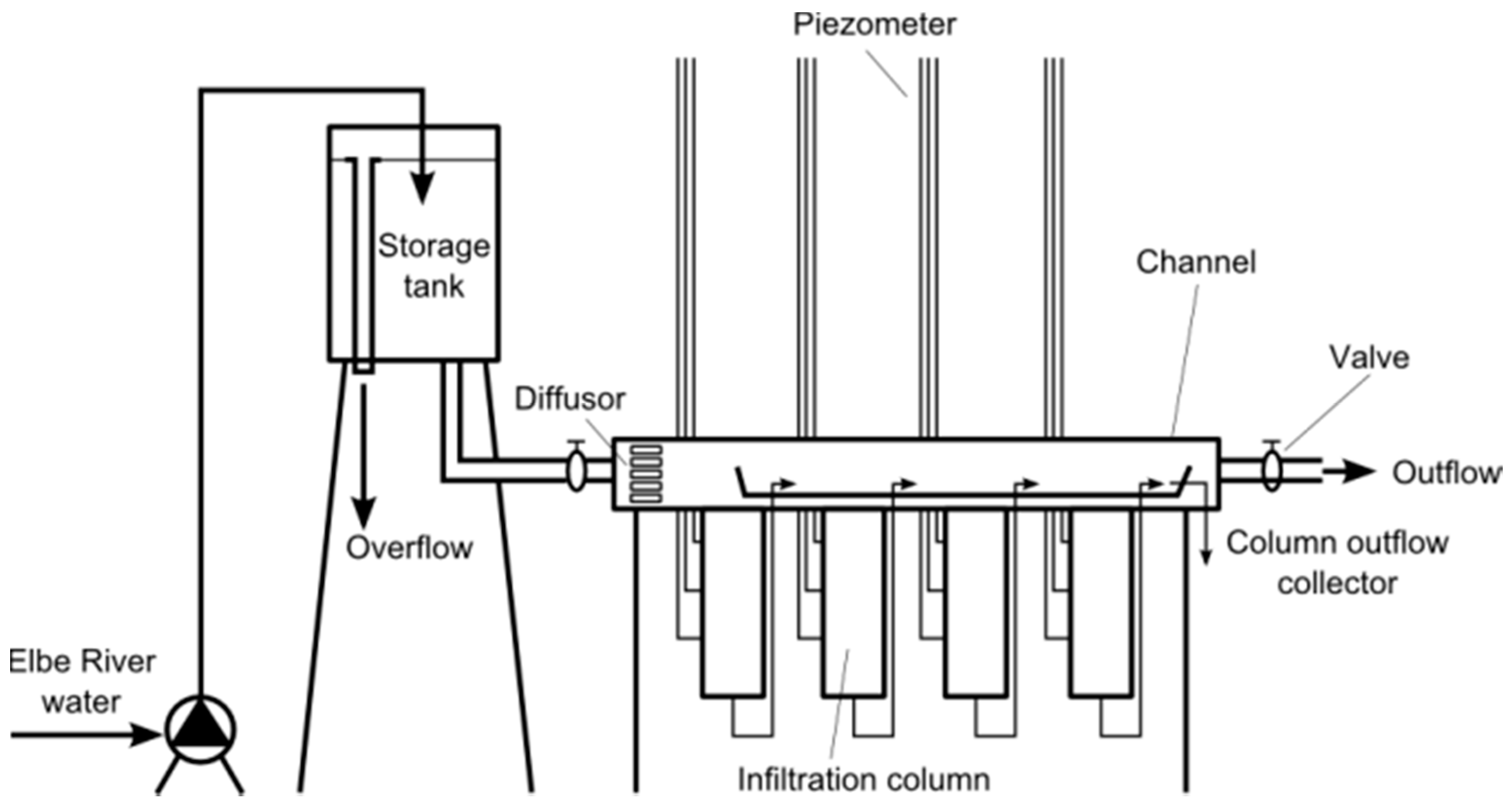
In order to simulate RBF processes, a special channel apparatus was built to investigate clogging at full scale. The apparatus (Figure 3) consisted of a closed, 1.2 m long horizontal rectangular channel that was used to simulate flow conditions in the river and allowed the adjustment of parameters such as flow velocity (max. 0.6 m/s), pressure (max. 1.5 m water column) and turbulence. A series of three to six vertical columns (L = 0.4 m, d = 87 mm), which simulated the clogging layer of the Elbe River, were attached to the bottom of the channel [14,15,17]. The columns were filled with riverbed sediment from different RBF sites. The sandy to gravelly sediments were taken layer-wise during low-flow conditions directly in front of the PW from depths of up to 0.4 m. The columns were packed accordingly and layer-wise. The top edge of every column and the bottom of the channel were also overlain by a 1–2 cm thick layer of the same sediment. During the infiltration test, fresh river water was continuously pumped (~1 L/s) to a storage tank equipped with an overflow (constant head). The channel was fed with water from the storage tank by gravity. As soon as water flowed through the channel, it also infiltrated into the columns. The rate of infiltration was initially adjusted manually by the piezometric head difference between the channel and the outflow tube of the columns. Through the course of the experiments, the infiltration rate declined as L decreased.

2.3. Analytical and Numerical Determination of Leakage Coefficients

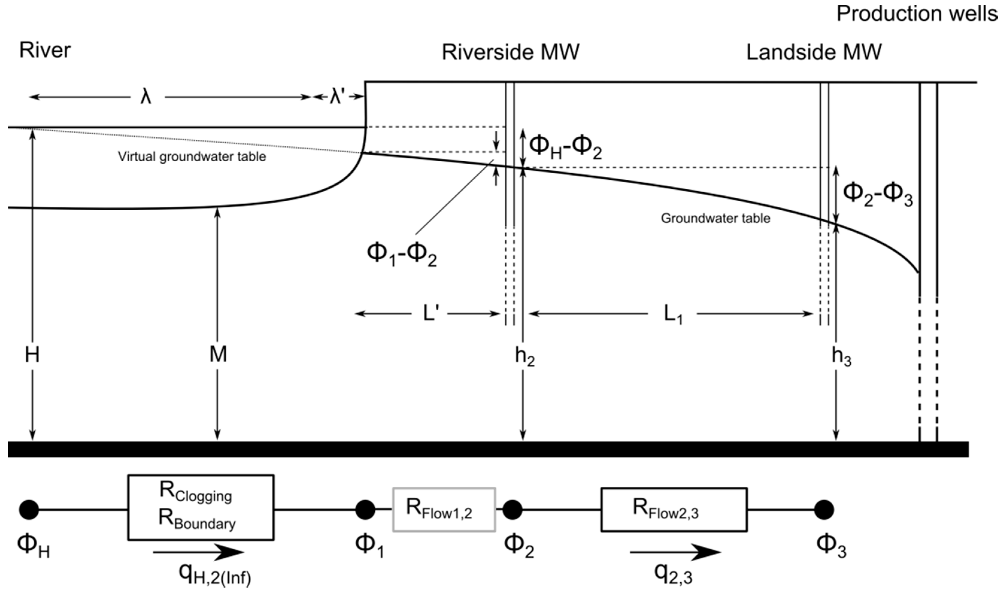
Based on one-dimensional, horizontal groundwater flow, [18,19,20] used w to transform the head loss caused by clogging into the “characteristic leakage length λ (m)” (Equation (2)). If a virtual image of a clogged river is shifted away from the PW by a distance of λ, it can be treated as an unclogged river boundary. The characteristic leakage length is defined as:
λ = kMw
where k (m/s) is the aquifer hydraulic conductivity and M (m) is the saturated thickness of the aquifer below the river. Under specific conditions (Figure 4), the characteristic leakage length λ can be calculated for RBF sites using water levels in the river and MW positioned between the river and the PW using an analytical solution (fragment approach). Otherwise, it has to be determined by calibration procedures in groundwater flow modeling.
For the calculation of λ, the groundwater monitoring transects are divided into two fragments (Figure 4). The following mass balance equation can be defined at the fragment intersection nodes, if there is no groundwater inflow flow from the opposite side of the river (Equations (3) and (4)). The discharge of the PW is indirectly included as drawdown and thus not directly required for the calculation. Φ H , Φ 2 , Φ 3 denote the Girinskij potential of the measured water levels.
q H , 2 ( Inf ) = q 2 , 3 = k λ ( Φ H Φ 2 )
q 2 , 3 = k L 1 ( Φ 2 Φ 3 )
The characteristic leakage length λ is calculated with Equation (5) and can be converted into the leakage factor with Equations (1) and (2). The riverside MW is often not located directly at the river–aquifer interface. Hence, the head loss caused by the flow from the river to the riverside MW is included in λ. For a homogenous aquifer, the head loss is equivalent to a distance L’ of the riverside MW from the river and must be abstracted from λ.
λ = L 1 · Φ H Φ 2 Φ 2 Φ 3 λ L
The term λ in Figure 4 is the head loss caused by streamline curvature underneath the river and can be estimated when river width > M using Equation (6) [19].
λ = 0.43 · M
At the WW Dresden–Tolkewitz, water levels were measured from 2008 to 2015 every 2 h. The daily average was used for the calculation of the leakage coefficient. The thickness M of the aquifer below the river is not constant (main channel deeper than banks) and difficult to determine. The saturated thickness M was therefore calculated as the mean of h2 and h3.

3. Results

3.1. Type of Clogging and Clogging Layer Thickness

The riverbed sediment at Dresden is composed of coarse gravel and pebbles [12]. The gravel is subject to sediment transport only during floods. Riverbed erosion at Dresden was stopped by the construction of bed sills. Bed erosion at Meissen was not observed since the 1970s. The riverbed at Torgau is composed of medium to fine gravel and characterized by erosive conditions. Clogging of the Elbe riverbed is of internal type along the sites in between Dresden and Torgau [12]. Outer clogging is prevented by shear stress and erosion. Beyer and Banscher [11] estimated an internal clogging depth for the Elbe River of 0.03 m for sand and 0.3 m for gravel. However, exact values cannot be given. Hydraulic conductivities estimated for the riverbed are of low value if no clogging depth is given. Clogging should therefore only be compared in terms of L or w, which can be derived from water level measurements or modeling.

3.2. Infiltration Resistance

In the early 1970s, Beyer and Banscher [11] conducted the first channel infiltration tests at several RBF sites along the upper Elbe River and identified mean values for the leakage coefficient in the range of L = 0.2–2 × 10⁻⁶ s−1. Hereby, initial values decreased by three orders of magnitude after about 50 days of infiltration. Grischek [14] repeated these tests in 1991–1995 and measured maximum values in the range of L = 2.4–30 × 10−6 s−1 after 50 days, which were one order of magnitude higher than those from the 1970s using comparable infiltration velocities. A value of L = 2.4 × 10⁻⁶ s−1 was estimated for the WW Dresden–Tolkewitz. Soares [15] conducted the latest channel tests in 2013. After 50 days of infiltration, values were three times higher than those estimated by [14] but had not approached a minimum value (plateau) after a further 34 days. A value of L = 5 × 10⁻⁶ s−1 after 365 days was estimated for the WW Dresden–Tolkewitz using a non-linear regression function.
The temporal decline in the clogging potential of Elbe River water in channel tests was also distinctly measurable when values from several groundwater monitoring programs (fragment approach) were compared with each other. Median values calculated with data measured before 1990 for the WW Dresden–Tolkewitz and WW Dresden–Hosterwitz (2 km apart from each other) were in the range of L = 0.45–1.25 × 10⁻⁶ s−1 respectively [12,19]. As the Elbe River quality improved significantly from 1991 to 1993, the leakage coefficients increased by a factor of 1.5 and 3.3 for the WW Dresden–Tolkewitz when values from 2008 to 2015 were compared to values from 1991 to 1993 and before 1990, respectively (Table 1).
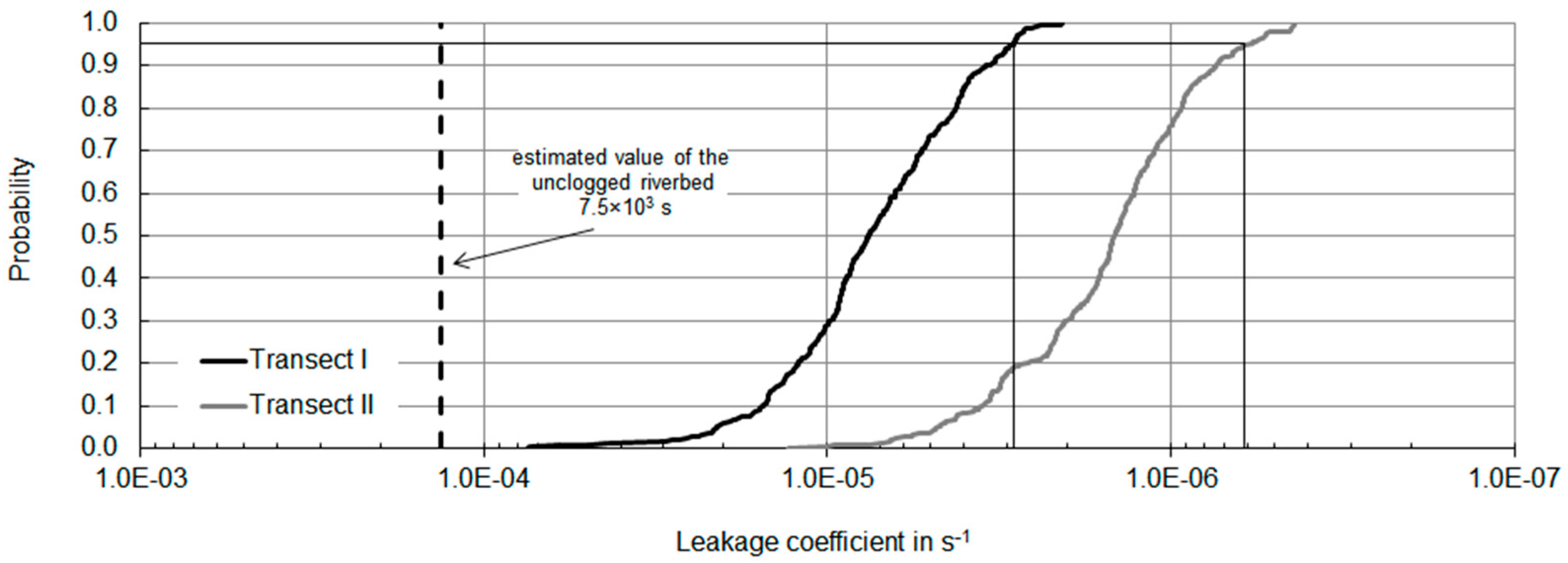
The analysis of L, based on long-term groundwater level monitoring programs, showed hydrological and seasonal variations. Values were strongly affected by the abstraction rate, riverbed scour, and temperature. For comparison, values calculated for both transects at WW Dresden–Tolkewitz (2008–2015) were plotted as probability distribution in Figure 5 (n = 385 and 387). Transect II is characterized by a higher specific abstraction rate and a lower leakage coefficient. Unfortunately, transect-specific estimates for the infiltration rate cannot be given. A direct link between low-flow conditions (low riverbed scour) and a low leakage coefficient was not apparent or compensated by temperature effects (Figure 6). Median water temperature varied between 2.5 and 21.1 °C. About 30% of the total values were calculated for low-flow conditions mainly during summer at transect II. Median and 75th percentile values of L were 2.5–5.7 times higher in the summer months compared to those in winter (December and January) at similar or lower river water levels in summer. Seasonal variations of L persisted but at lower amplitudes when river water temperature was used to normalize the calculated values to 10 °C. This may be attributed to biological activity. Both an increase in river water levels and a reduction of Q at a given river level resulted in an increase of L, which indicated that clogging was not permanent.

3.3. Comparison of Different Methods to Estimate the Leakage Coefficient

Riverbed clogging was investigated using infiltrometer tests, channel tests and groundwater levels. Leakage values obtained from infiltrometer tests were one to two magnitudes higher compared to channel experiments (Table 2). Channel tests theoretically represent low-flow conditions with minimal shear stress. However, values for the WW Dresden–Tolkewitz were still considerably above those obtained using the fragment approach, which is considered to be robust and to reflect real conditions, as the resistance is determined indirectly through on-site water level measurements. At the site WW Torgau–Ost, with an average aquifer thickness of 60 m compared to 11–14 m at WW Dresden–Tolkewitz, values from the fragment approach were lower than the channel experiments. This was attributed to the erosive conditions at Torgau, which could not be simulated in the channel, as well as the large aquifer thickness.

4. Discussion

At Tolkewitz, a significant decrease in groundwater levels was observed between 1914 and 1930 and attributed to riverbed clogging by suspended solids since the start of operation (1901). In the 1980s, severe river water pollution caused by organics from pulp and paper mills in conjunction with high water abstraction led to unsaturated conditions beneath the riverbed. A leakage coefficient of 1 × 10⁻⁴ s−1 was calculated for the riverbed without RBF and a mean value of L = 5 × 10⁻⁷ s−1 before 1990. After improvement of river water quality from 1991 to 1993, hydraulic conductivity of the riverbed increased. In 1991–1993 and 2008–2015, a mean leakage coefficient of L = 1–1.5 × 10⁻⁶ s−1 was determined at transect II. In 2015, a median leakage coefficient of L = 4 × 10⁻⁶ s−1 was determined during a summer long low-flow period with moderate abstraction. Even though one may expect stronger clogging under these drought conditions, the high water temperatures, higher biological activity [20,21,22] and the ship traffic during lower river stage with stronger impact of propulsion systems on the riverbed [23] are assumed to have a positive effect on riverbed leakage.
An accurate estimation of the leakage coefficient is theoretically possible through infiltrometer tests but difficult to carry out in coarse material, at flow velocities >1 m/s, at depths >1 m and with ship traffic. They will also require a large number of measurements to allow generalized statements [24,25]. Channel tests represent low-flow conditions; even effects such as erosion (from riverbed scour and ship traffic) can be simulated to some extent. However, it was apparent that values for L from channel experiments in Dresden–Tolkewitz were higher than those derived from analytical and numerical models. This may be attributed to the artificial filling of the columns with riverbed material (destruction of fine layers existing in the natural riverbed and long-term bioclogging).
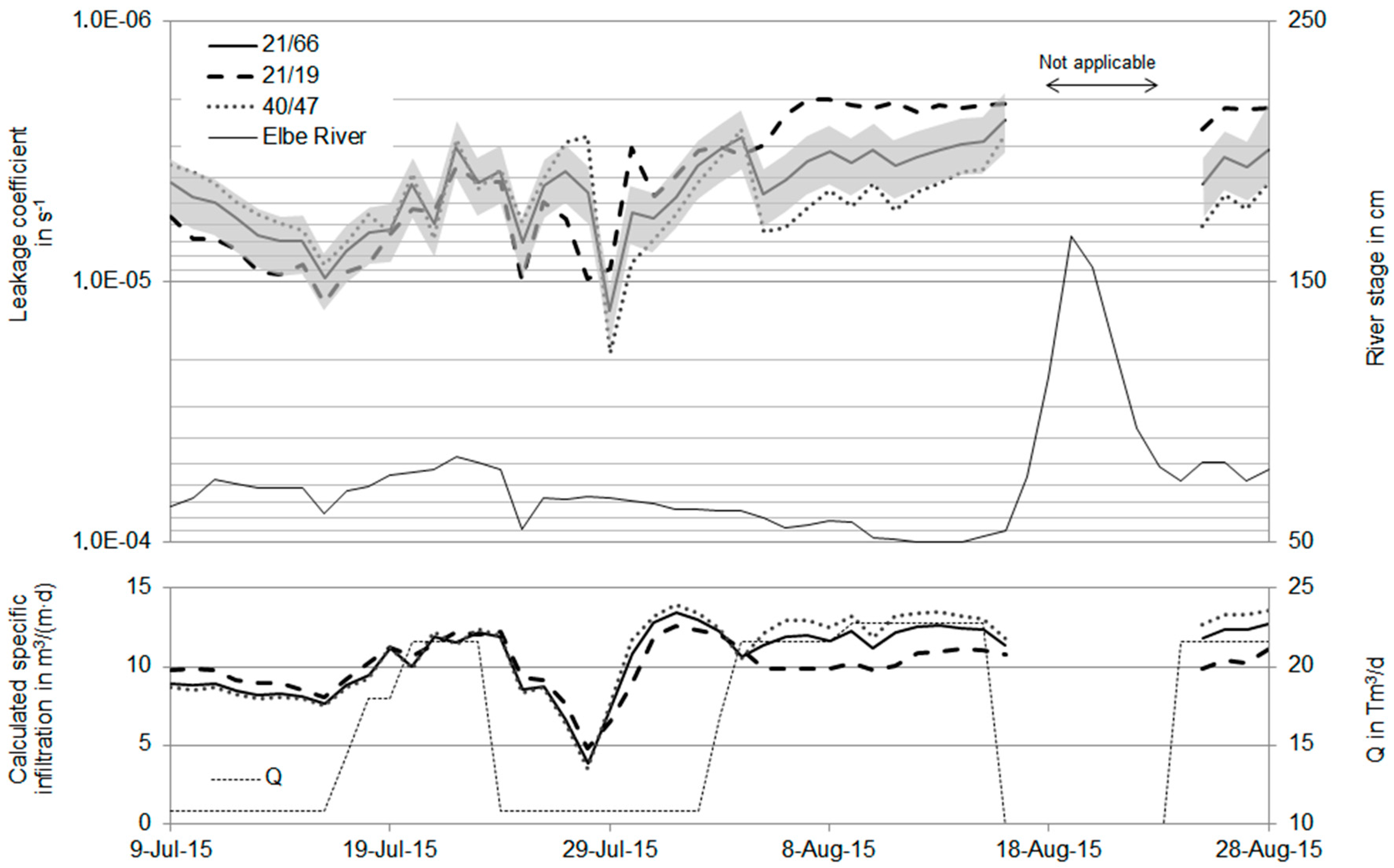
The fragment approach was found to be robust and reliable. It reflected long-term changes in riverbed leakage due to an improved water quality as well as short-term variations caused by variations in seasonal water temperature, river stage and abstraction rates. The evaluation and analysis of groundwater levels is relatively simple, less time-consuming than transient groundwater flow modeling (which requires the same input data) and only requires at least two MW aligned in-line and rectangular to the river bank for groundwater level monitoring. The riverside MW should be placed in L′ > H distance from the river [26] (no streamflow curvature). Flow variations and subsequent water level fluctuations were found to be acceptable when water level fluctuations were limited to a maximum of ΔH = 0.15 m within 3 days for the WW Dresden–Tolkewitz. Based on simultaneous water level measurements over a period of 51 days at three MW along one transect, the distance between the two MW or from the riverbank was found to have no significant effect (<10% on the median value) (Table 3, Figure 7). The mean absolute error (MAE) was higher because daily values were directly compared with each other and without respect to the reaction time of the aquifer. The difficulty at the WW Dresden–Tolkewitz was that the three siphon pipes (or sections of it) including their PW were connected and disconnected upon operational experience and sometimes switched off, although total abstraction was constant (4–16 August 2015). Hence, if wells were operated consistently over the entire period, it is assumed that the MAE would have been smaller. The sensitivity of L to λ′ (Equation (6)) and M depends on the order of L. The higher L, the higher is the impact of λ′. From July to August 2015 (Figure 7), mean λ′ was calculated to be 4.65 m at transect I (L = 4.8 × 10⁻⁶–1.9 × 10⁻⁵ s−1) and 4.60 m at transect II (L = 2.4 × 10⁻⁶–9.6 × 10⁻⁶ s−1). By not considering λ′ in Equation (5), L would have been overestimated: 14%–25% and 10%–19%, on average 18% and 13%. A change of M (Equations (2) and (6)) by ±25% affected L on average by −37%–26% at transect I and −30%–28% at transect II.
The fragment approach is based on one-dimensional, horizontal flow for a series of wells parallel to the river. Once a pilot site and a series of at least three wells has been installed, quantitative estimates of the long-term clogging behavior can be obtained from the fragment approach, which can feed into numerical modeling to estimate feasible abstraction rates for the design of a large-scale site nearby the pilot site or the gradual enlargement of the pilot site. This is demonstrated in Figure 8, where the recoverable share of BF was simulated as a function of L. Note that the calculated discharge is based on a transient model (240 days) with a stepwise decrease of the river stage (low-flow period). It is site specific and assumes a maximum allowable drawdown based on the PW system at the site.
A rule of thumb established before 1990 for the design of RBF sites along the upper Elbe River was that 10,000 m3/day riverbank filtrate (no landside groundwater) can be safely and sustainably abstracted from a section of the Elbe River with a length of 1000 m. Before 1990, the WW Dresden–Tolkewitz was affected by severe clogging. Mean calculated share of BF varied upon river flow conditions between 16,250 and 19,200 m3/day per 1000 m [16]. The mean for low-flow conditions is in good agreement with the simulated value in Figure 8. As water quality has significantly improved and the leakage factor has increased, the theoretical recoverable share of BF increased for the same drawdown. Interestingly, the analysis of groundwater levels between 2008 and 2015 indicated that the lowest estimated leakage factors do not necessarily need to be applied to extreme low-flow conditions, which mainly appear during the summer months and which are characterized by the highest peak water demands.

5. Conclusions

An alternative, cost and time efficient method is presented to estimate accurate leakage coefficients. The analytical solution is based on groundwater level monitoring data from observation wells next to the river, which can later feed into numerical models. The analytical approach was able to reflect long-term changes as well as seasonal variations.
Because riverbed clogging is inevitable, RBF wells must be operated according to the site conditions. In Dresden, severe clogging of the riverbed occurred in the 1980s mainly due to high loads of organics from pulp and paper mills upstream. The observed slime at the riverbed surface, which was assumed to act as an organic outer clogging layer, reduced the volume of river water recharged into the aquifer. In terms of management, the total pumped water volume had to be reduced to reestablish saturated conditions below the riverbed. A prerequisite for this action was that clogging was monitored. The alternative was to increase the length of infiltration area by the construction of additional wells to maintain a constant production capacity. Following improvement of river water quality in the 1990s, no problems with riverbed clogging have been encountered. Long-term experiences and results of the evaluation of historic and recent data strongly indicate that RBF is a sustainable water resource for water supply along the Elbe River, despite clogging. Based on long-term experience from RBF sites along the River Rhine, Elbe and other European Rivers, an infiltration rate of 0.2 m3/(m2∙day) was found sustainable [9] but is currently subject to further investigations. A critical value for L cannot be given as this very much depends on the site conditions and on the pumped water volume.
The authors see enormous potential for wider use of RBF worldwide, especially given that the removal of microbial pathogens from surface water through RBF would be a crucial factor [27,28]. Thus, it could serve as a preferable alternative to direct river water abstraction. At a minimum, bank filtration acts as a pre-treatment step in drinking water production. In some instances, it can serve as the final treatment just before disinfection. Bank filtration also serves as an asset to water suppliers by way of capital cost reduction through lower maintenance, improved reliability of source water and enhanced community supply by lowering the total dissolved solids concentration [9]. Nevertheless, the application and adaptation of RBF is very much site-specific and demands careful investigations into hydrological, hydrogeological, hydrochemical and hydrobiological conditions, especially clogging of river (as done in Thailand [29]) or lake beds and redox reactions in the aquifer.

Acknowledgments

The latest investigations in this paper were performed as cooperation between the DREWAG Netz GmbH and the Division of Water Sciences at the University of Applied Sciences. The authors are grateful to the BMBF for funding the project “FHprofUnt2012—Optimization of bank filtration and subsurface removal of iron and manganese” (03FH042PX2). The paper was completed by further analysis supported by the AquaNES project, which has received funding from the European Union’s Horizon 2020 research and innovation programme under grant agreement No. 689450.

Author Contributions

Thomas Grischek reviewed previous literature, conducted several experiments within his Ph.D. thesis and supervised the clogging studifes after 2003, Rico Bartak conducted the latest groundwater level monitoring from 2012 to 2015, performed the fragment approach calculations for data from 2008 to 2015 and the modeling.

Conflicts of Interest

The authors declare no conflict of interest. The founding sponsors had no role in the design of the study; in the collection, analyses, or interpretation of data; in the writing of the manuscript, and in the decision to publish the results.

References

  1. Hubbs, S.A. Changes in riverbed hydraulic conductivity and specific capacity at Louisville. In Riverbank Filtration Hydrology; Hubbs, S.A., Ed.; NATO Science Series IV; Earth and Environmental Sciences: Dordrecht, The Netherlands, 2006; pp. 199–220. [Google Scholar]
  2. Schubert, J. Significance of hydrologic aspects on RBF performance. In Riverbank Filtration Hydrology; Hubbs, S.A., Ed.; NATO Science Series IV; Earth and Environmental Sciences: Dordrecht, The Netherlands, 2006; pp. 1–21. [Google Scholar]
  3. Schälchli, U. Clogging of Surface Water Bed: Processes and Calculations. Ph.D. Thesis, ETH Zürich, Zürich, Switzerland, 1993. [Google Scholar]
  4. Rinck-Pfeiffer, S.; Ragusa, S.; Sztajnbok, P.; Vandevelde, T. Interrelationships between biological, chemical and physical processes as an analog to clogging in aquifer storage and recovery (ASR) wells. Water Resour. 2000, 34, 2110–2118. [Google Scholar] [CrossRef]
  5. WSA; (The Waterways and Shipping Board, Magdeburg, Germany). Personal communication, 2016.
  6. IKSE International Commission for Protection of the Elbe River, Gradient, Flow Velocity and Travel Time Elbe River. The Elbe River and Its Catchment Basin (German). p. 212. Available online: http://www.ikse-mkol.org/uploads/media/IKSE-Elbe-und-ihr-Einzugsgebiet-2005-Kap5-2.pdf (accessed on 7 April 2016).
  7. DREWAG; (Dresden, Germany). Unpublished water quality data. 2011.
  8. Nestler, W.; Socher, M.; Grischek, T.; Schwan, M. River Bank Infiltration in the Upper Elbe River Valley: Hydrochemical Aspects; IAHS Publ.: Vienna, Austria, 1991; pp. 347–356. [Google Scholar]
  9. Grischek, T.; Schoenheinz, D.; Eckert, P.; Ray, C. Sustainability of river bank filtration: Examples from Germany. In Groundwater Quality Sustainability; Maloszewski, P., Witczak, S., Malina, G., Eds.; Taylor & Francis Group: London, UK, 2012; pp. 213–227. [Google Scholar]
  10. Banscher, E. Contribution to the Evaluation of Clogging Processes along Streams. Ph.D. Thesis, TU Dresden, Department of Water Sciences, Dresden, Germany, 1975. [Google Scholar]
  11. Beyer, W.; Banscher, E. On the methodology for riverbank filtration site investigation. Z. Angew. Geol. 1976, 22, 149–154. (In German) [Google Scholar]
  12. Heeger, D. Investigation of Clogging Processes in Rivers. Ph.D. Thesis, TU Bergakademie Freiberg, Department of Math & Natural Sciences, Dresden, Germany, 1987. [Google Scholar]
  13. Grischek, T.; Macheleidt, W.; Nestler, W. River bed specifics and their effect on bank filtration efficiency. In Management of Aquifer Recharge for Sustainability; Dillon, P., Ed.; Balkema Publ.: Lisse, The Netherlands, 2002; pp. 59–64. [Google Scholar]
  14. Grischek, T. Management of RBF along the Elbe River. Ph.D. Thesis, Dresden University of Technology, Department of Water Sciences, Dresden, Germany, 2003. [Google Scholar]
  15. Soares, M. The Influence of High Infiltration Rates, Suspended Sediment Concentration and Sediment Grain Size on River and Lake Bed Clogging. Ph.D. Thesis, TU Berlin, Faculty III-Process Sciences, Berlin, Germany, 2015. [Google Scholar]
  16. Heeger, D.; (WW Dresden-Tolkewitz, Germany). Unpublished technical report. 1988.
  17. Beyer, W.; (Methodology for Riverbank Filtration Site Investigation, Dresden University of Technology, Department of Water Sciences, Dresden, Germany). Unpublished work. 1974.
  18. Busch, K.F.; Luckner, L.; Tiemer, K. Textbook Hydrogeology—Geohydraulics (German), 3rd ed.; Gebrueder Borntraeger: Berlin/Stuttgart, Germany, 1993; pp. 186–211. [Google Scholar]
  19. Beims, U. One dimensional flow. In Textbook Hydrogeology—Groundwater Exploration; Bahlke, K.D., Beims, U., Heers, F.W., Hölting, B., Homrighausen, R., Matthess, G., Eds.; Gebrueder Borntraeger: Berlin/Stuttgart, Germany, 2000; pp. 130–195. (In German) [Google Scholar]
  20. Nogaro, G.; Mermillod-Blondin, F.; Montuelle, B.; Boisson, J.-C.; Gibert, J. Chironomid larvae stimulate biogeochemical and microbial processes in a riverbed covered with fine sediment. Aquat. Sci. 2008, 70, 156–158. [Google Scholar] [CrossRef]
  21. Smith, J.W.N. Groundwater–Surface Water Interactions in the Hyporheic Zone; Environment Agency: Bristol, UK, 2005; No. SC030155/SR1. [Google Scholar]
  22. Fischer, H.; Kloep, F.; Wilzcek, S.; Pusch, M.T. A river’s liver—Microbial processes within the hyporheic zone of a large lowland river. Biogeochemistry 2005, 76, 349–371. [Google Scholar] [CrossRef]
  23. Roemisch, K. Hydrodynamic Effects of Ships in Canals; Mitt. Franzius-Inst.: Hannover, Germany, 1990; p. 295. (In German) [Google Scholar]
  24. Landon, M.K.; Rus, D.L.; Harvey, F.E. Comparison of instream methods for measuring hydraulic conductivity in sandy streambeds. Ground Water 2001, 39, 870–885. [Google Scholar] [CrossRef] [PubMed]
  25. Rosenberry, D.O.; LaBaugh, J.W. Field Techniques for Estimating Water Fluxes between Surface Water and Ground Water; U.S. Geological Survey Techniques and Methods 4–D2; U.S. Geological Survey: Reston, VA, USA, 2008; p. 128.
  26. Zipfel, K. Groundwater Recovery along Rivers with Self-Sealing Riverbed. Ph.D. Thesis, Karlsruhe University, Karlsruhe, Germany, 1965. [Google Scholar]
  27. Sandhu, C.; Grischek, T.; Kumar, P.; Ray, C. Potential for riverbank filtration in India. Clean Technol. Environ. Policy 2011, 13, 295–316. [Google Scholar] [CrossRef]
  28. Ghodeif, K.; Grischek, T.; Bartak, R.; Wahaab, R.; Herlitzius, J. Potential of river bank filtration (RBF) in Egypt. Environ. Earth Sci. 2016, 75, 1–13. [Google Scholar] [CrossRef]
  29. Pholkern, K.; Srisuk, K.; Grischek, T.; Soares, M.; Schäfer, S.; Archwichai, L.; Saraphirom, P.; Pavelic, P.; Wirojanagud, W. Riverbed clogging experiments at potential river bank filtration sites along the Ping River, Chiang Mai, Thailand. Environ. Earth Sci. 2015, 73, 7699–7709. [Google Scholar] [CrossRef]
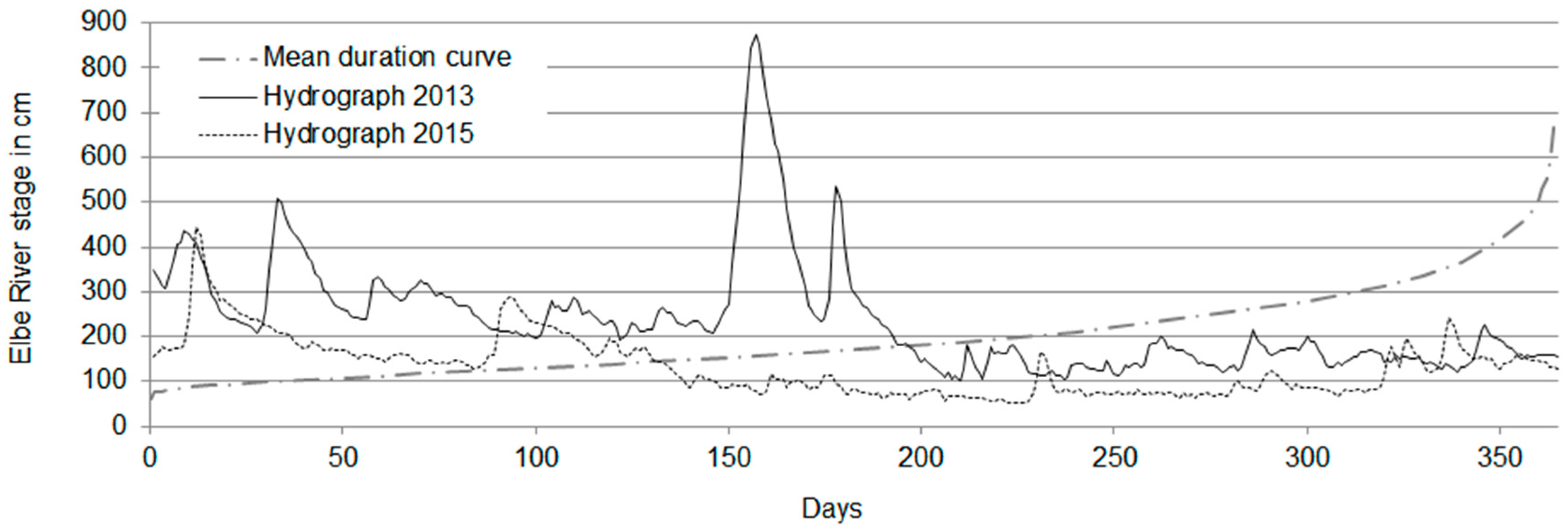
Figure 1. Elbe River flow conditions at Dresden (55.63 km; [5]).
Water 08 00604 g001
Figure 2. Location map water works Dresden–Tolkewitz.
Water 08 00604 g002
Figure 3. Channel setup (adopted from [13]).
Water 08 00604 g003
Figure 4. Geohydraulic scheme for the calculation of λ using the fragment approach (R = resistance).
Water 08 00604 g004
Figure 5. Probability plot for leakage coefficient at WW Dresden–Tolkewitz (2008–2015).
Water 08 00604 g005
Figure 6. Comparison of river stage against (a) total abstraction; (b) leakage coefficient at transect II.
Water 08 00604 g006
Figure 7. Temporal variations in L calculated for different MW-separation distances at transect II, grey zone marks ±25% from 21/66.
Water 08 00604 g007
Figure 8. Theoretically recoverable share of bank filtrate for a 1000-m-long river stretch during low-flow based on a groundwater flow modeling for WW Dresden–Tolkewitz.
Water 08 00604 g008
Table 1. Temporal increase in leakage coefficient (in 10−6 s−1) at transect II, WW Dresden–Tolkewitz.
MethodParameterBefore 19901991–19932008–2015
Fragment
Approach
Leakage coefficient in s−10.45 *,#11.5 *
Cross comparison in %3067100
Channel
Test
Leakage coefficient in s−10.2–2.0 x2.4 $,+5 $,y
Cross comparison in %4–4048100
Notes: * Median; # [12]; x [11]; + [14]; y [15]; $ minimum plateau value.
Table 2. Mean values for L in 10−6 s−1 at riverbank filtration sites along the upper Elbe River, 1991–1993 [14].
Siteq in m3/(m·day)ChannelInfiltrometerFragment Approach
DD Tolkewitz9.75n.d.1
(0.4–1.3)
Meissen–Siebeneichen1.53
(2–10)
200
(125–500)
n.d. *
Torgau–Ost15.810
(2.5–20)
250
(125–1000)
100
(5–200)
Notes: n.d.: not determined; * not applicable due to discontinuous well operation.
Table 3. Effect of monitoring well- separation distance at transect II (Fragment approach).
Distance from River/Distance between MW in (m)21/6621/1940/47
Median L in s−14.2 × 10−64.0 × 10−64.6 × 10⁻⁶
Cross Comparison in %10094110
MAE in % (excl. 4–16 August 2015)02316