
Implications of Texture and Erodibility for Sediment Retention in Receiving Basins of Coastal Louisiana Diversions


Abstract
:1. Introduction

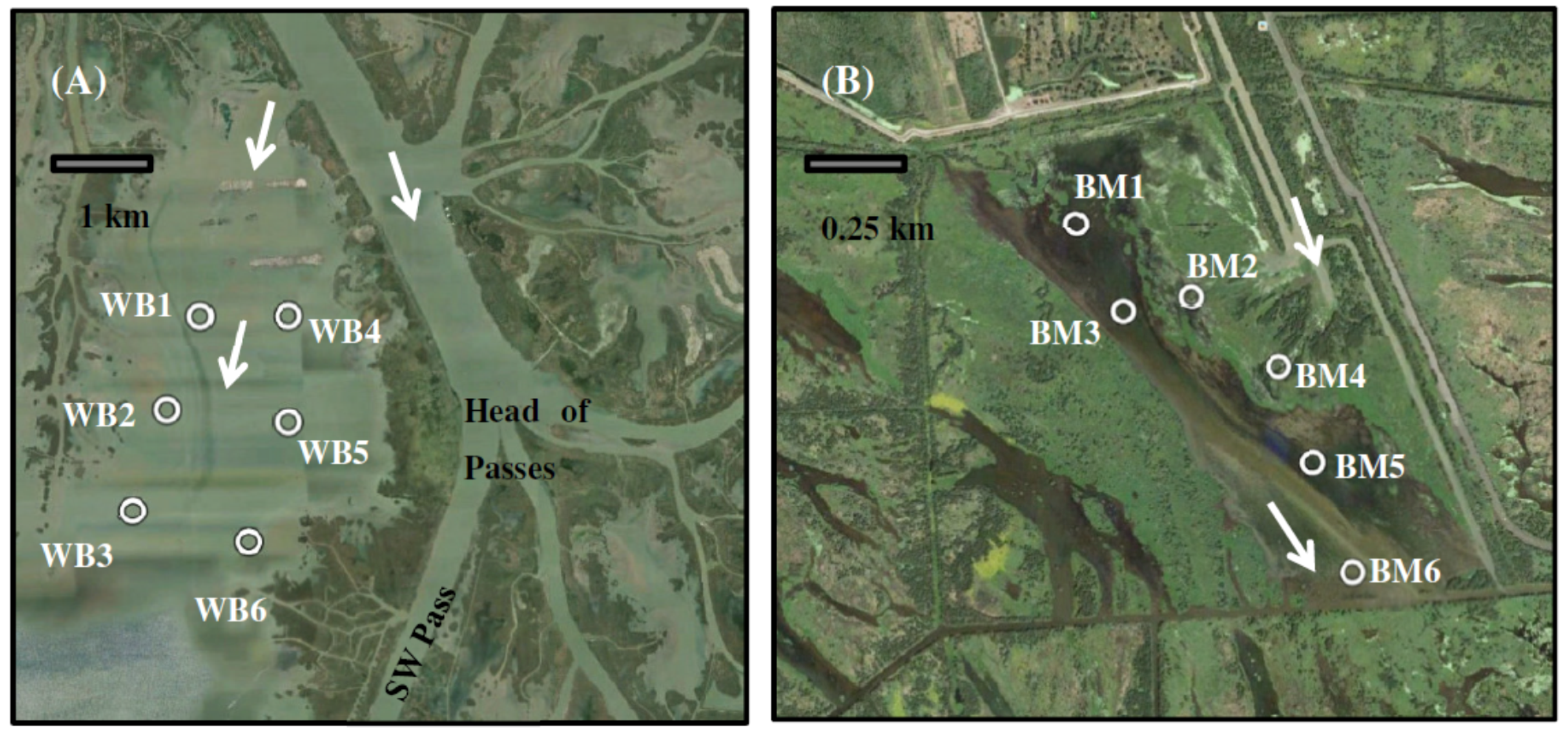
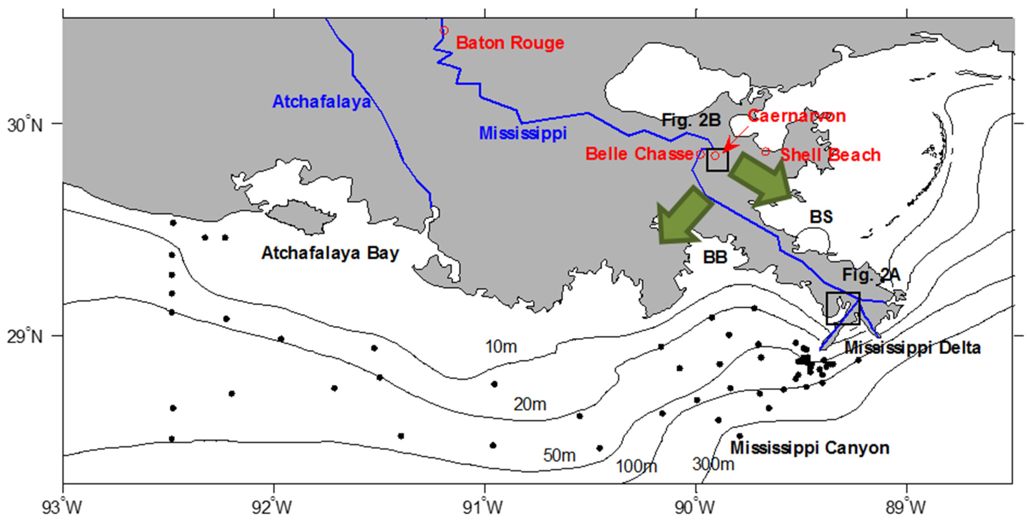
2. Study Areas

| Study Area | Area before Diversion (km2) | Tidal Range (m) | Subsidence Rate (mm/year) | Connectivity to Open Ocean | Purpose of Diversion | Water Discharge (km3/year) | Sediment Discharge (Mt/year) |
|---|---|---|---|---|---|---|---|
| West Bay | 40 a | 0.3 m a | 15 b | semi-enclosed | sediment diversion and nourishing marsh | 33 c | 3.2 c |
| Big Mar | 4 | negligible | 3 b | enclosed | water diversion for salinity control now. planned for sediment diversion in the future | 2 c | 0.2 c |
3. Methods
3.1. Coring
| Study Area | Station | Fieldtrip Date | Water Depth (m) | Longitude | Latitude | TSS (mg/L) | Organic Matter Percent of Surficial Sediment (%) |
|---|---|---|---|---|---|---|---|
| West Bay | WB1 | 19 November 2014 | 0.91 | 89°18.962′ W | 29°10.187′ N | 12.95 | 2.16 |
| WB2 | 19 November 2014 | 1.34 | 89°19.455′ W | 29°9.128′ N | 26.65 | 3.50 | |
| WB3 | 20 November 2014 | 1.52 | 89°19.962′ W | 29°7.985′ N | 11.25 | 4.28 | |
| WB4 | 19 November 2014 | 1.22 | 89°17.821′ W | 29°10.148′ N | 17.10 | 5.77 | |
| WB5 | 19 November 2014 | 1.22 | 89°17.871′ W | 29°8.933′ N | N.D. | 5.38 | |
| WB6 | 20 November 2014 | 1.37 | 89°18.458′ W | 29°7.582′ N | 10.75 | 4.88 | |
| Average | - | 1.26 | - | - | 15.74 | 4.33 | |
| Big Mar | BM1 | 7 March 2015 | 0.23 | 89°54.982′ W | 29°50.577′ N | 120.35 | 12.94 |
| BM2 | 6 March 2015 | 0.10 | 89°54.601′ W | 29°50.338′ N | 69.91 | 5.81 | |
| BM3 | 7 March 2015 | 0.34 | 89°54.826′ W | 29°50.301′ N | 48.19 | 12.80 | |
| BM4 | 6 March 2015 | 0.20 | 89°54.292′ W | 29°50.113′ N | 108.20 | 7.09 | |
| BM5 | 7 March 2015 | 0.17 | 89°54.190′ W | 29°49.818′ N | 75.49 | 6.09 | |
| BM6 | 7 March 2015 | 0.35 | 89°54.067′ W | 29°49.483′ N | 57.57 | 13.63 | |
| Average | - | 0.23 | - | - | 79.95 | 9.73 |
3.2. Total Suspended Solid
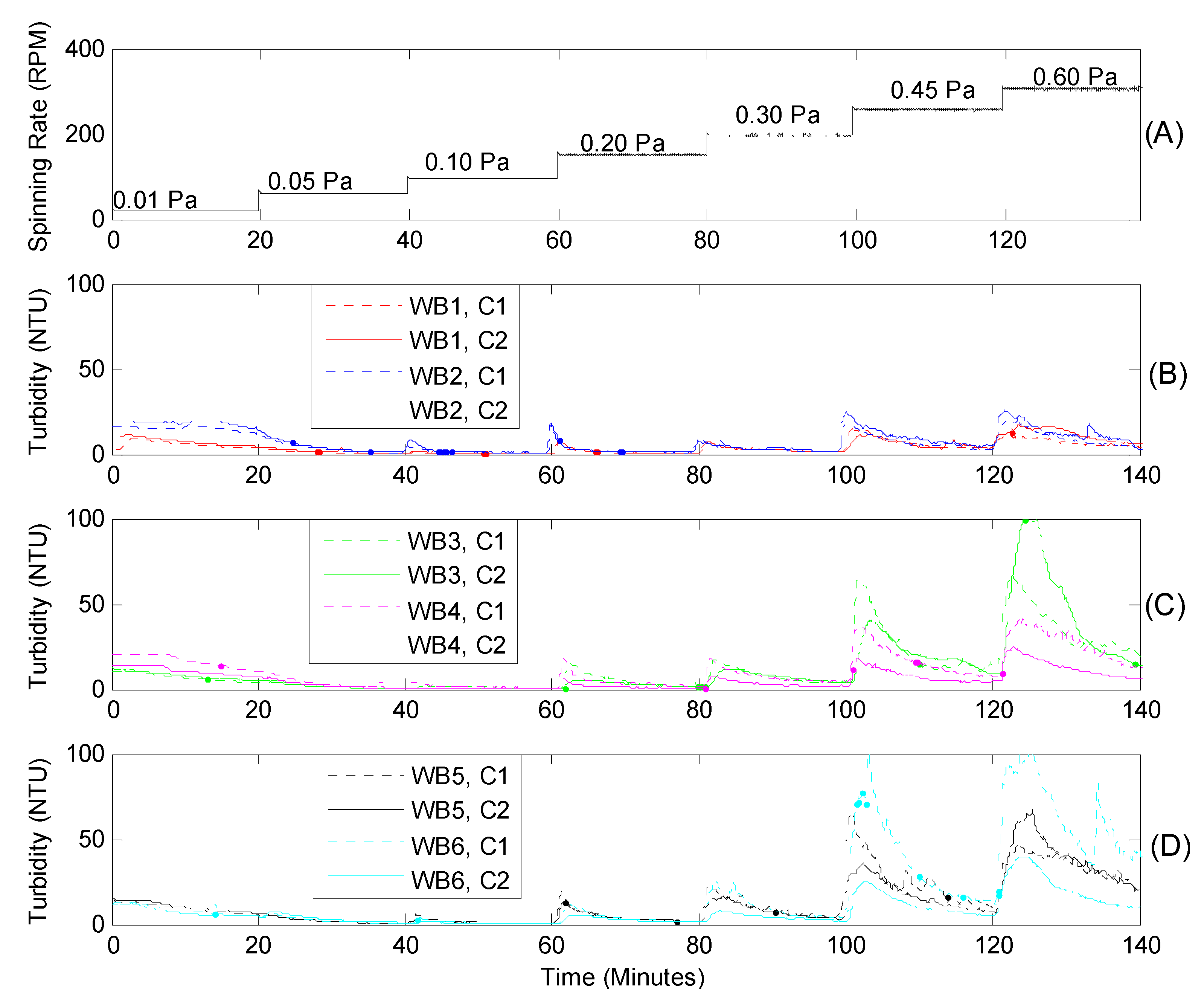
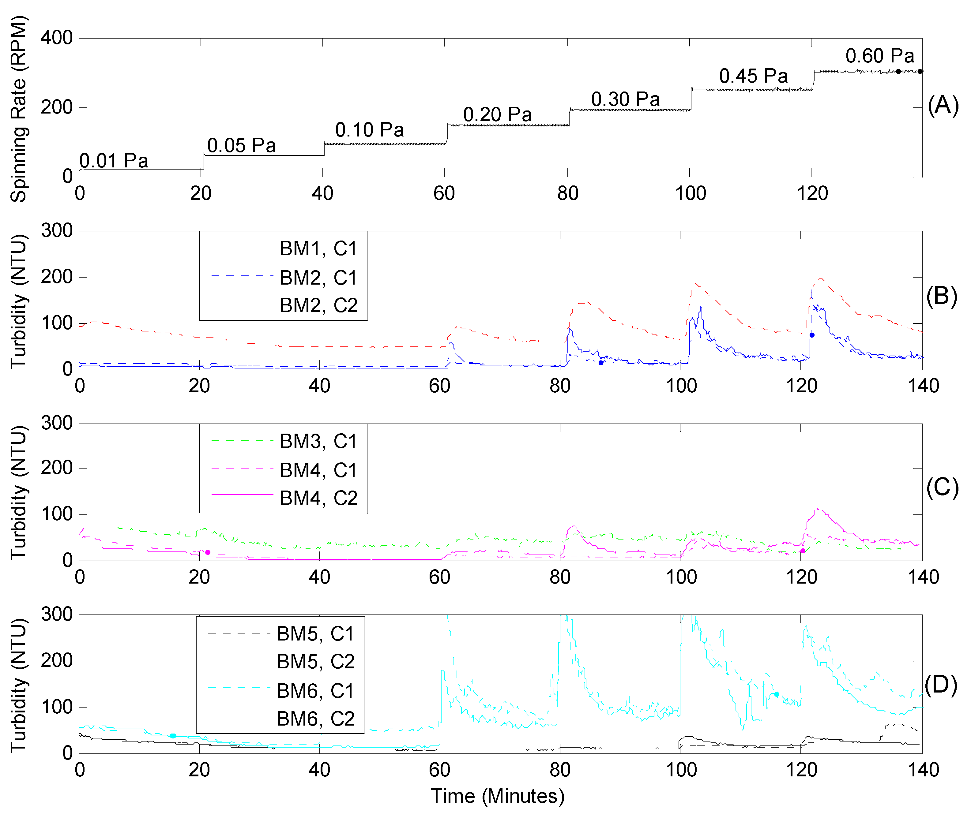
3.3. Field Measurement of Erodibility
3.4. Grain Size Analysis
3.5. Organic Matter Analysis
3.6. Wave and Shear Stress Calculation
4. Results
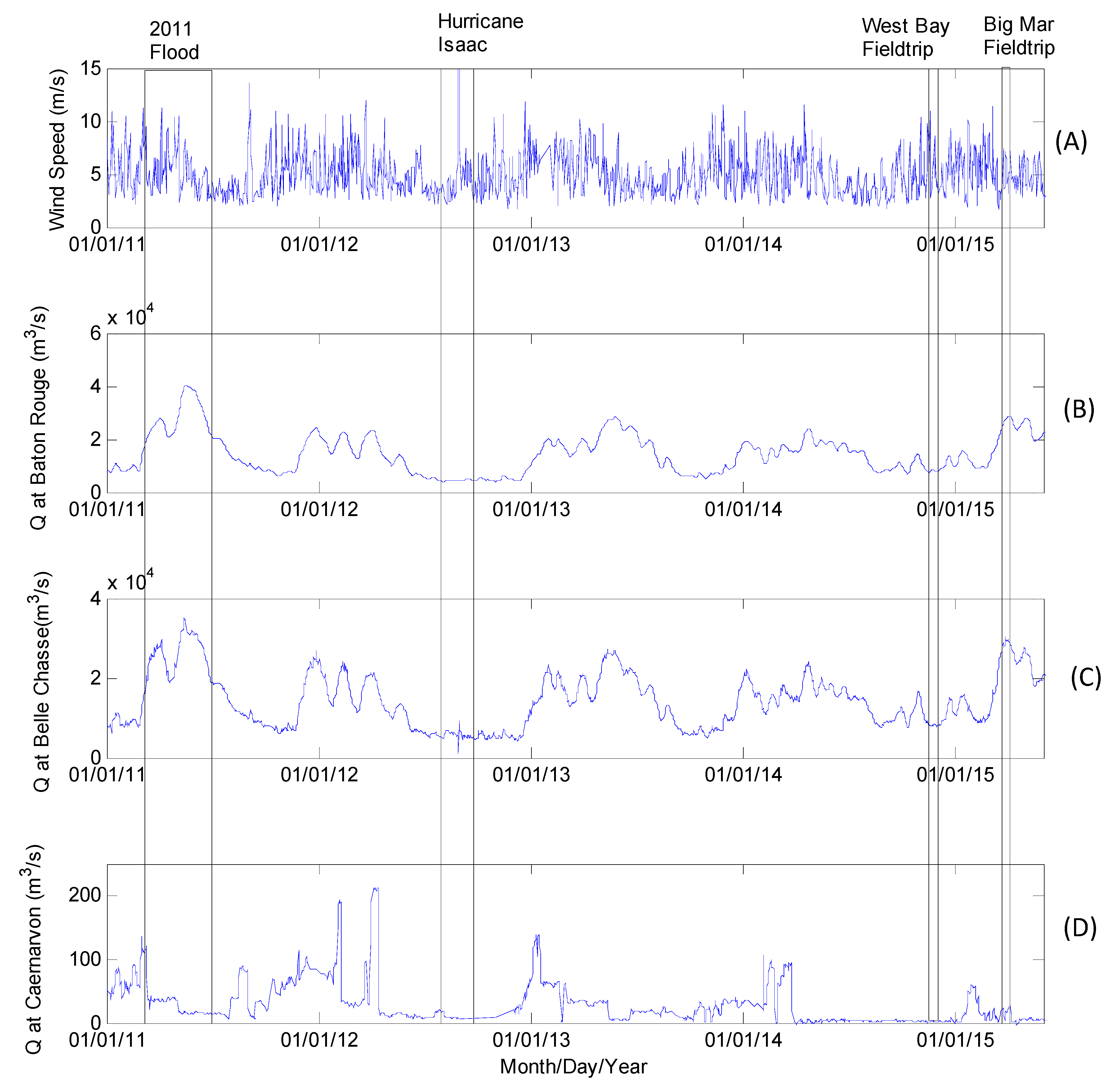
4.1. Wind and Discharge

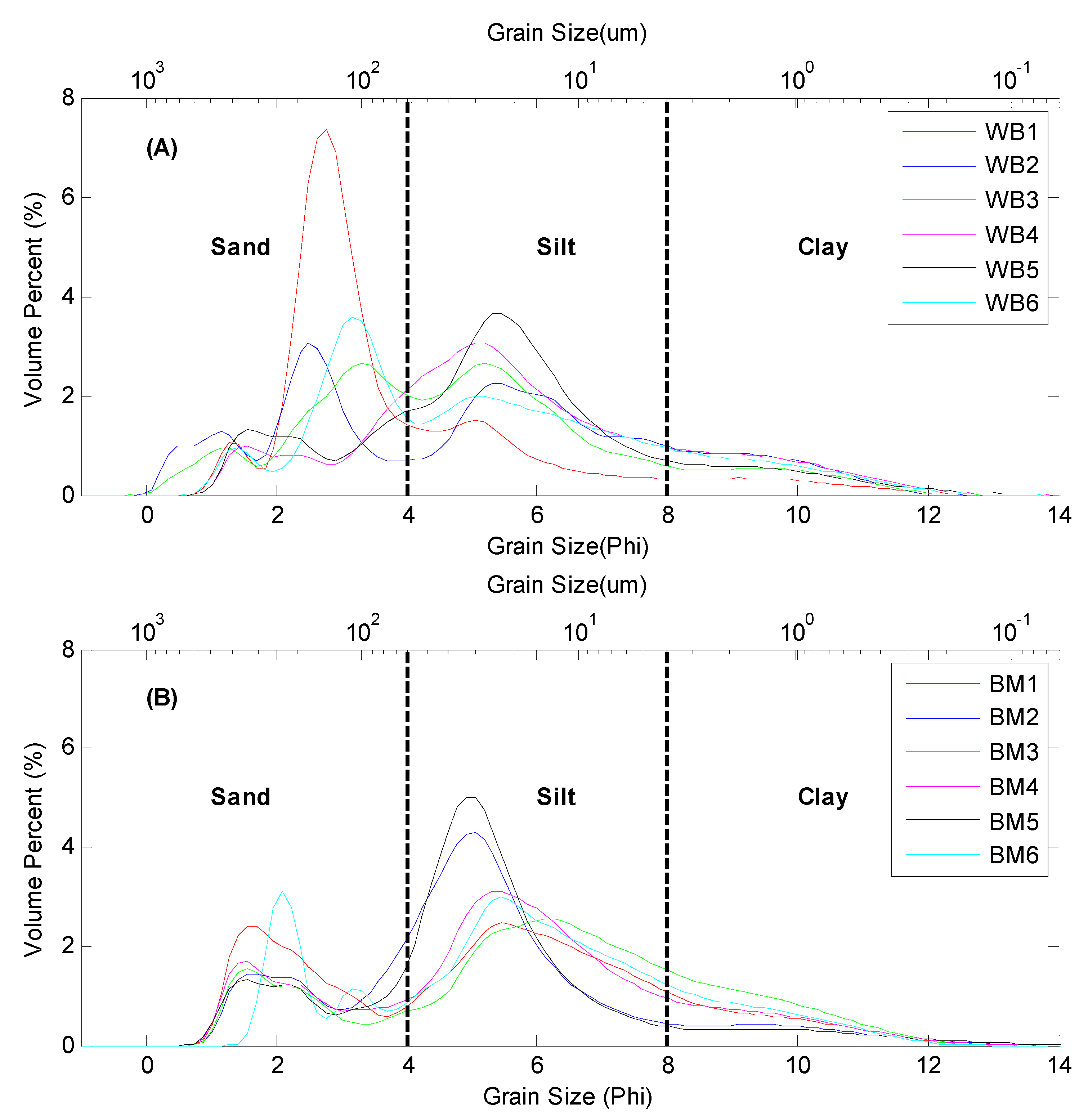
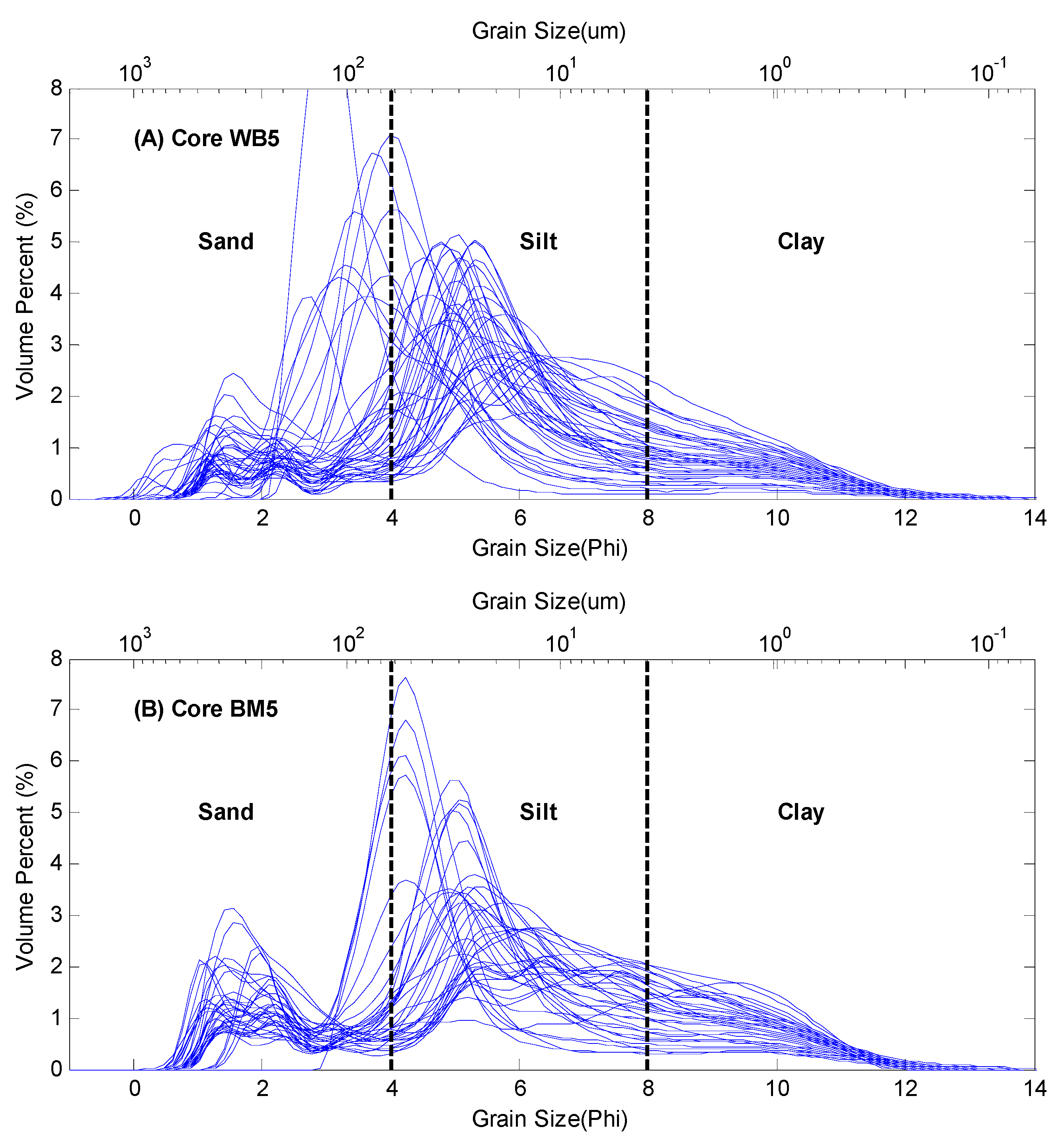
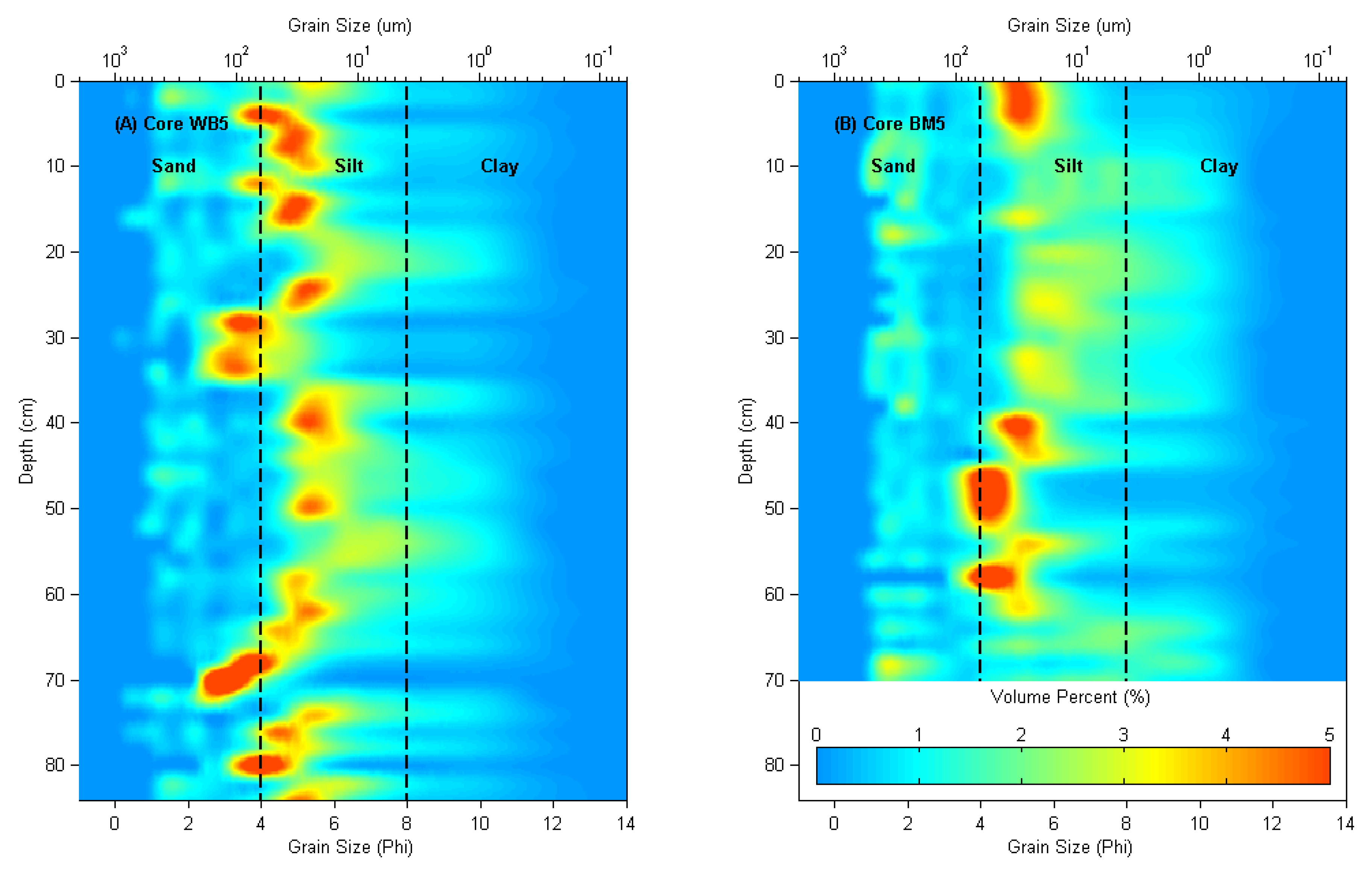
4.2. Grain Size

| Study | Area | Number of Samples | Type | Sand (%) | Silt (%) | Clay (%) |
|---|---|---|---|---|---|---|
| This Study | West Bay | 6 | Surficial | 38.7 | 47.7 | 13.6 |
| This Study | Big Mar | 6 | Surficial | 24.9 | 60.1 | 14.9 |
| This Study | West Bay Core WB5 | 42 | Down-core | 25.4 | 58.2 | 16.4 |
| This Study | Big Mar Core BM5 | 35 | Down-core | 24.6 | 56.0 | 19.4 |
| Bentley et al. [42] | Lower Breton Sound | 296 | Down-core | 23.2 | 50.7 | 26.1 |
| Bentley et al. [43] | Middle Breton Sound | 258 | Down-core | 24.8 | 52.0 | 23.2 |
| Bentley et al. [42] | Lower Barataria Bay | 243 | Down-core | 24.9 | 52.9 | 22.2 |
| Bentley et al. [43] | Middle Barataria Bay | 271 | Down-core | 16.0 | 54.5 | 29.5 |
| Elliton et al. [44] | Mike Island, Wax Lake Delta | 29 | Surficial | 19.9 | 62.1 | 18.0 |
| All | 1191 | - | 24.7 | 54.9 | 20.4 | |
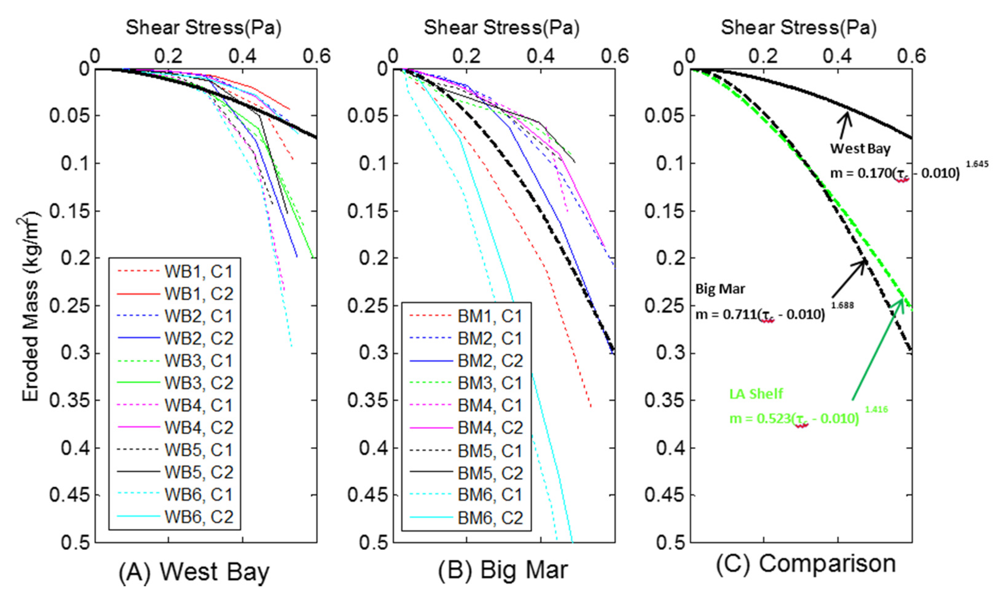
4.3. Erodibility
5. Discussion
5.1. Critical Shear Stress and Erodibility Comparison
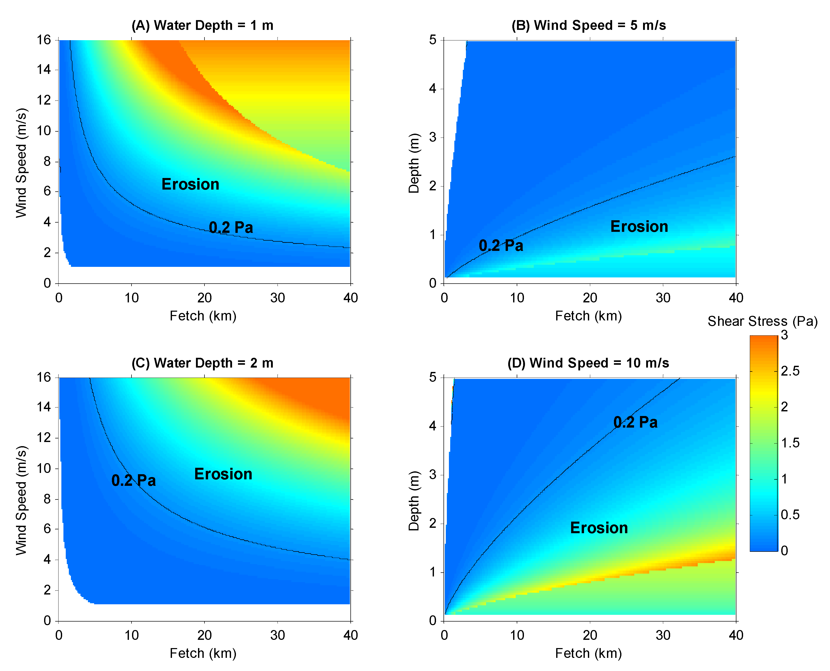
5.2. Shear Stress in Louisiana Bays

5.3. Sediment Texture
5.4. Sediment Retention Rate
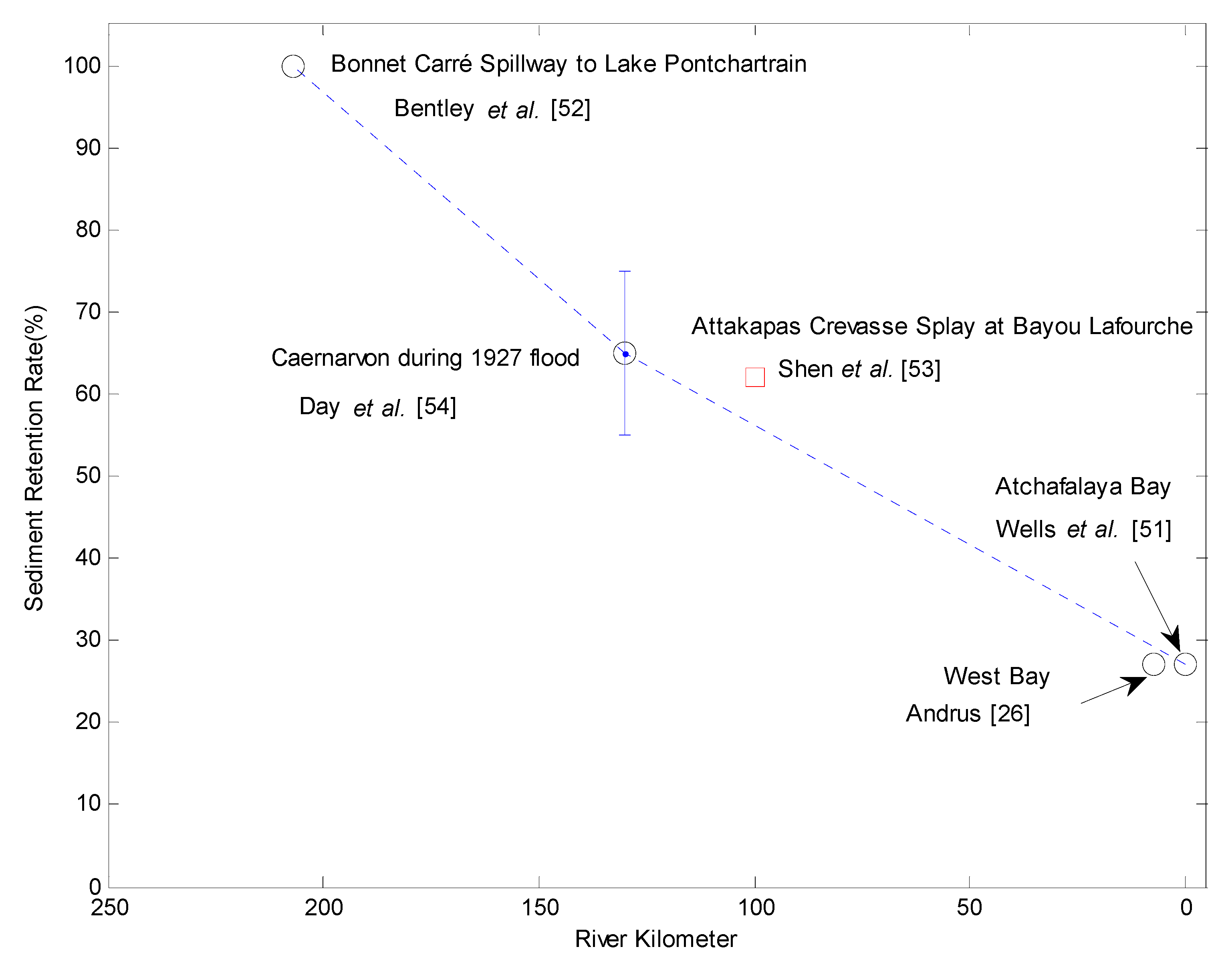
5.5. Implication for Sediment Diversion
6. Conclusions
Acknowledgments
Author Contributions
Conflicts of Interest
References
- Syvitski, J.P.M.; Saito, Y. Morphodynamics of deltas under the influence of humans. Glob. Planet. Chang. 2007, 57, 261–282. [Google Scholar] [CrossRef]
- Syvitski, J.P.M.; Kettner, A.J.; Overeem, I.; Hutton, E.W.H.; Hannon, M.T.; Brakenridge, G.R.; Day, J.; Vorosmarty, C.; Saito, Y.; Giosan, L.; et al. Sinking deltas due to human activities. Nat. Geosci. 2009, 2, 681–686. [Google Scholar] [CrossRef]
- Vörösmarty, C.J.; Syvitski, J.; Day, J.; Sherbinin, A.D.; Giosan, L.; Paola, C. Battling to save the world's river deltas. Bull. At. Sci. 2009, 65, 31–43. [Google Scholar] [CrossRef]
- Tessler, Z.D.; Vörösmarty, C.J.; Grossberg, M.; Gladkova, I.; Aizenman, H.; Syvitski, J.P.M.; Foufoula-Georgiou, E. Profiling risk and sustainability in coastal deltas of the world. Science 2015, 349, 638–643. [Google Scholar] [CrossRef] [PubMed]
- Temmerman, S.; Kirwan, M.L. Building land with a rising sea. Science 2015, 349, 588–589. [Google Scholar] [CrossRef] [PubMed]
- Couvillion, B.R.; Barras, J.A.; Steyer, G.D.; Sleavin, W.; Fischer, M.; Beck, H.; Trahan, N.; Griffin, B.; Heckman, D. Land Area Change in Coastal Louisiana from 1932 to 2010: U.S. Geological Survey Scientific Investigations Map 3164, scale 1:265,000. 2011. Available online: http://pubs.usgs.gov/sim/3164/ (accessed on 18 January 2016). [Google Scholar]
- Day, J.W.; Boesch, D.F.; Clairain, E.J.; Kemp, G.P.; Laska, S.B.; Mitsch, W.J.; Orth, K.; Mashriqui, H.; Reed, D.J.; Shabman, L.; et al. Restoration of the mississippi delta: Lessons from Hurricanes Katrina and Rita. Science 2007, 315, 1679–1684. [Google Scholar] [CrossRef] [PubMed]
- Tornqvist, T.E.; Wallace, D.J.; Storms, J.E.A.; Wallinga, J.; van Dam, R.L.; Blaauw, M.; Derksen, M.S.; Klerks, C.J.W.; Meijneken, C.; Snijders, E.M.A. Mississippi delta subsidence primarily caused by compaction of holocene strata. Nat. Geosci. 2008, 1, 173–176. [Google Scholar] [CrossRef]
- Blum, M.D.; Roberts, H.H. Drowning of the mississippi delta due to insufficient sediment supply and global sea-level rise. Nat. Geosci. 2009, 2, 488–491. [Google Scholar] [CrossRef]
- Allison, M.A.; Meselhe, E.A. The use of large water and sediment diversions in the lower mississippi river (louisiana) for coastal restoration. J. Hydrol. 2010, 387, 346–360. [Google Scholar] [CrossRef]
- Meade, R.H.; Moody, J.A. Causes for the decline of suspended-sediment discharge in the mississippi river system, 1940–2007. Hydrol. Process. 2010, 24, 35–49. [Google Scholar] [CrossRef]
- Bentley, S.J.; Blum, M.D.; Maloney, J.; Pond, L.; Paulsell, R. The mississippi river source-to-sink system: Perspectives on Tectonic, Climatic, and Anthropogenic Influences, Miocene to Anthropocene. Earth Sci. Rev. 2015. [Google Scholar] [CrossRef]
- Coastal Protection and Restoration Authority (CPRA). Louisiana′s Comprehensive Master Plan for a Sustainable Coast; Coastal Protection and Restoration Authority of Louisiana: Baton Rouge, LA, USA, 2012.
- Allison, M.A.; Demas, C.R.; Ebersole, B.A.; Kleiss, B.A.; Little, C.D.; Meselhe, E.A.; Powell, N.J.; Pratt, T.C.; Vosburg, B.M. A water and sediment budget for the lower mississippi–atchafalaya river in flood years 2008–2010: Implications for Sediment Discharge to the Oceans and Coastal Restoration in Louisiana. J. Hydrol. 2012, 432–433, 84–97. [Google Scholar] [CrossRef]
- Kolker, A.S.; Miner, M.D.; Weathers, H.D. Depositional dynamics in a river diversion receiving basin: The Case of the West Bay Mississippi River Diversion. Estuar. Coast. Shelf Sci. 2012, 106, 1–12. [Google Scholar] [CrossRef]
- Turner, R.E.; Baustian, J.J.; Swenson, E.M.; Spicer, J.S. Wetland sedimentation from hurricanes katrina and rita. Science 2006, 314, 449–452. [Google Scholar] [CrossRef] [PubMed]
- Smith, J.; Bentley, S.; Snedden, G.; White, C. What role to hurricanes play in sediment delivery to subsiding river deltas? Sci. Rep. 2015, 5. [Google Scholar] [CrossRef] [PubMed]
- Xu, K.; Corbett, D.R.; Walsh, J.P.; Young, D.; Briggs, K.B.; Cartwright, G.M.; Friedrichs, C.T.; Harris, C.K.; Mickey, R.C.; Mitra, S. Seabed erodibility variations on the louisiana continental shelf before and after the 2011 mississippi river flood. Estuar. Coast. Shelf Sci. 2014, 149, 283–293. [Google Scholar] [CrossRef]
- Paola, C.; Twilley, R.R.; Edmonds, D.A.; Kim, W.; Mohrig, D.; Parker, G.; Viparelli, E.; Voller, V.R. Natural processes in delta restoration: Application to the Mississippi Delta. Annu. Rev. Mar. Sci. 2011, 3, 67–91. [Google Scholar] [CrossRef] [PubMed]
- Grabowski, R.C.; Droppo, I.G.; Wharton, G. Erodibility of cohesive sediment: The Importance of Sediment Properties. Earth Sci. Rev. 2011, 105, 101–120. [Google Scholar] [CrossRef]
- Roberts, H.H. Delta switching: Early Responses to the Atchafalaya River Diversion. J. Coast. Res. 1998, 14, 882–899. [Google Scholar]
- Soulsby, R. Dynamics of marine sands: A Manual for Practical Applications; Thomas Telford: London, UK, 1997. [Google Scholar]
- Whitehouse, R.J.S.; Soulsby, R.L.; Roberts, W.; Mitchener, H.J. Dynamics of Estuarine Muds, a Manual for Practical Applications; Thomas Telford: London, UK, 2000. [Google Scholar]
- Mickey, R.; Xu, K.; Libes, S.; Hill, J. Sediment texture, erodibility, and composition in the northern gulf of mexico and their potential impacts on hypoxia formation. Ocean Dyn. 2015, 65, 269–285. [Google Scholar] [CrossRef]
- Lo, E.; Bentley, S.J.; Xu, K. Experimental study of cohesive sediment consolidation and resuspension identifies approaches for coastal restoration: Lake Lery, Louisiana. Geo Mar. Lett. 2014, 34, 499–509. [Google Scholar] [CrossRef]
- Andrus, T.M. Sediment Flux and Fate in the Mississippi River Diversion at West Bay: Observation Study; Louisiana State University: Baton Rouge, LA, USA, 2007. [Google Scholar]
- Coleman, J.M.; Gagliano, S.M. Cyclic sedimentation in the mississippi river deltaic plain. Gulf Coast Assoc. Geol. Soc. Trans. 1964, 14, 67–80. [Google Scholar]
- Lane, R.; Day, J.; Day, J. Wetland surface elevation, vertical accretion, and subsidence at three louisiana estuaries receiving diverted mississippi river water. Wetlands 2006, 26, 1130–1142. [Google Scholar] [CrossRef]
- Lane, R.; Day, J.; Thibodeaux, B. Water quality analysis of a freshwater diversion at Caernarvon, Louisiana. Estuaries 1999, 22, 327–336. [Google Scholar] [CrossRef]
- Huang, H.; Justic, D.; Lane, R.R.; Day, J.W.; Cable, J.E. Hydrodynamic response of the breton sound estuary to pulsed mississippi river inputs. Estuar. Coast. Shelf Sci. 2011, 95, 216–231. [Google Scholar] [CrossRef]
- Lopez, J.A.; Henkel, T.K.; Moshogianis, A.M.; Baker, A.D.; Boyd, E.C.; Hillmann, E.R.; Connor, P.F.; Baker, D.B. Examination of deltaic processes of mississippi river outlets-caernarvon delta and bohemia spillway in southeastern louisiana. Gulf Coast Assoc. Geol. Sci. Trans. 2014, 3, 79–93. [Google Scholar]
- Gust, G.; Muller, V. Interfacial hydrodynamics and entrainment functions of currently used erosion devices. In Cohesive Sediments; Burt, N., Parker, R., Watts, J., Eds.; Wiley: Wallingford, UK, 1997; pp. 149–174. [Google Scholar]
- Sanford, L.P.; Maa, J.P.Y. A unified erosion formulation for fine sediments. Mar. Geol. 2001, 179, 9–23. [Google Scholar] [CrossRef]
- Dickhudt, P.J.; Friedrichs, C.T.; Schaffner, L.C.; Sanford, L.P. Spatial and temporal variation in cohesive sediment erodibility in the york river estuary, eastern USA: A Biologically Influenced Equilibrium Modified by Seasonal Deposition. Mar. Geol. 2009, 267, 128–140. [Google Scholar] [CrossRef]
- Dickhudt, P.J.; Friedrichs, C.T.; Sanford, L.P. Mud matrix solids fraction and bed erodibility in the york river estuary, USA, and other muddy environments. Cont. Shelf Res. 2011, 31. [Google Scholar] [CrossRef]
- Sanford, L.P. Uncertainties in sediment erodibility estimates due to a lack of standards for experimental protocols and data interpretation. Integr. Environ. Assess. Manag. 2006, 2, 29–34. [Google Scholar] [CrossRef] [PubMed]
- Xu, K.; Sanger, D.; Riekerk, G.; Crowe, S.; van Dolah, R.F.; Wren, P.A.; Ma, Y. Seabed texture and composition changes offshore of port royal sound, south carolina before and after the dredging for beach nourishment. Estuar. Coast. Shelf Sci. 2014, 149, 57–67. [Google Scholar] [CrossRef]
- Folk, R.L. A review of grain-szie parameters. Sedimentology 1966, 6, 73–93. [Google Scholar] [CrossRef]
- Heiri, O.; Lotter, A.; Lemcke, G. Loss on ignition as a method for estimating organic and carbonate content in sediments: Reproducibility and Comparability of Results. J. Paleolimnol. 2001, 25, 101–110. [Google Scholar] [CrossRef]
- US Army Corps of Engineers (US-ACE). Coastal Engineering Manual 1110-2-1100; US Army Corps of Engineers: Washington, DC, USA, 2002. [Google Scholar]
- LD, W. Morphodynamics of Inner Continental Shelves; CRC Press: Boca Raton, FL, USA, 1995. [Google Scholar]
- Bentley, S.J.; Xu, K.; Chen, Q. Data Report: Geological and Geotechnical Characterization for Lower Barataria Bay and Lower Breton Sound Diversion Receiving Basins; Coastal Studies Technical Report for the Water Institute of the Gulf; The Water Institute of the Gulf: Baton Rouge, LA, USA, February 2015. [Google Scholar]
- Bentley, S.J.; Xu, K.; Chen, Q. Data Report: Geological and Geotechnical Characterization for Middle Barataria Bay and Middle Breton Sound Diversion Receiving Basins; Coastal Studies Technical Report for the Water Institute of the Gulf; The Water Institute of the Gulf: Baton Rouge, LA, USA, October 2015. [Google Scholar]
- Elliton, C.; Xu, K.; Rivera-Monroy, V.H.; Twilley, R.R.; Castañeda-Moya, E. Riverine sediment pulsing and plant-sediment interactions drive changes in sediment dynamics in naturally created deltas. In Proceedings of the Ocean Sciences Meeting, New Orleans, LA, USA, 21–26 Feburary 2016.
- Wright, L.D.; Sherwood, C.R.; Sternberg, R.W. Field measurements of fairweather bottom boundary layer processes and sediment suspension on the louisiana inner continental shelf. Mar. Geol. 1997, 140, 329–345. [Google Scholar] [CrossRef]
- Xu, K.; Harris, C.K.; Hetland, R.D.; Kaihatu, J.M. Dispersal of mississippi and atchafalaya sediment on the texas–louisiana shelf: Model Estimates for the Year 1993. Cont. Shelf Res. 2011, 31, 1558–1575. [Google Scholar] [CrossRef]
- Xu, K.; Mickey, R.C.; Chen, Q.; Harris, C.K.; Hetland, R.D.; Hu, K.; Wang, J. Shelf sediment transport during hurricanes katrina and rita. Comput. Geosci. 2015. [Google Scholar] [CrossRef]
- Mariotti, G.; Fagherazzi, S. Critical width of tidal flats triggers marsh collapse in the absence of sea-level rise. Proc. Natl. Acad. Sci. USA 2013, 110, 5353–5356. [Google Scholar] [CrossRef] [PubMed]
- Twilley, R.R.; Sr, S.J.B.; Chen, Q.J.; Edmonds, D.A.; Hagen, S.C.; Lam, N.; Willson, C.S.; Xu, K.; Braud, D.; Peele, H. Co-evolution of wetland landscapes, flooding and human settlement in the mississippi river deltaic plain. Sustain. Sci. 2016, in press. [Google Scholar]
- Meselhe, E.A.; Georgiou, I.; Allison, M.A.; McCorquodale, J.A. Numerical modeling of hydrodynamics and sediment transport in lower mississippi at a proposed delta building diversion. J. Hydrol. 2012, 472–473, 340–354. [Google Scholar] [CrossRef]
- Wells, J.T.; Chinburg, S.J.; Coleman, J.M. The Atchafalaya River Delta, Report 4: Generic Analysis of Delta Development; Technical Report HL82-15; US Army Corps of Engineers: Vicksburg, MS, USA, 1984. [Google Scholar]
- Bentley, S.J.; Fabre, J.; Li, C.; Smith, E.; Walker, N.; White, J.R.; Rouse, L.; Bargu, S. Fluvial Sediment Flux during High Discharge Events: Harnessing Mississippi River Sediment to Build New Land on an Endangered Coast. In Proceedings of the Ocean Sciences Meeting, Salt Lake City, UT, USA, 20–24 Feburary 2012.
- Shen, Z. Using the late holocene stratigraphic record to guide mississippi delta restoration. In Proceedings of the State of the Coast Conference, New Orleans, LA, USA, 18–20 March 2014.
- Day, J.W.; Cable, J.E.; Lane, R.R.; Kemp, G.P. Sediment deposition at the Caernarvon Crevasse during the great Mississippi Flood of 1927: Implications for Coastal Restoration. Water 2016, in press. [Google Scholar]
© 2016 by the authors; licensee MDPI, Basel, Switzerland. This article is an open access article distributed under the terms and conditions of the Creative Commons by Attribution (CC-BY) license (http://creativecommons.org/licenses/by/4.0/).
Share and Cite
Xu, K.; Bentley, S.J.; Robichaux, P.; Sha, X.; Yang, H. Implications of Texture and Erodibility for Sediment Retention in Receiving Basins of Coastal Louisiana Diversions. Water 2016, 8, 26. https://doi.org/10.3390/w8010026
Xu K, Bentley SJ, Robichaux P, Sha X, Yang H. Implications of Texture and Erodibility for Sediment Retention in Receiving Basins of Coastal Louisiana Diversions. Water. 2016; 8(1):26. https://doi.org/10.3390/w8010026
Chicago/Turabian StyleXu, Kehui, Samuel J. Bentley, Patrick Robichaux, Xiaoyu Sha, and Haifei Yang. 2016. "Implications of Texture and Erodibility for Sediment Retention in Receiving Basins of Coastal Louisiana Diversions" Water 8, no. 1: 26. https://doi.org/10.3390/w8010026
APA StyleXu, K., Bentley, S. J., Robichaux, P., Sha, X., & Yang, H. (2016). Implications of Texture and Erodibility for Sediment Retention in Receiving Basins of Coastal Louisiana Diversions. Water, 8(1), 26. https://doi.org/10.3390/w8010026