Isotopes as Tracers of Water Origin in and Near a Regional Carbonate Aquifer: The Southern Sacramento Mountains, New Mexico


Abstract
:1. Introduction
2. Background
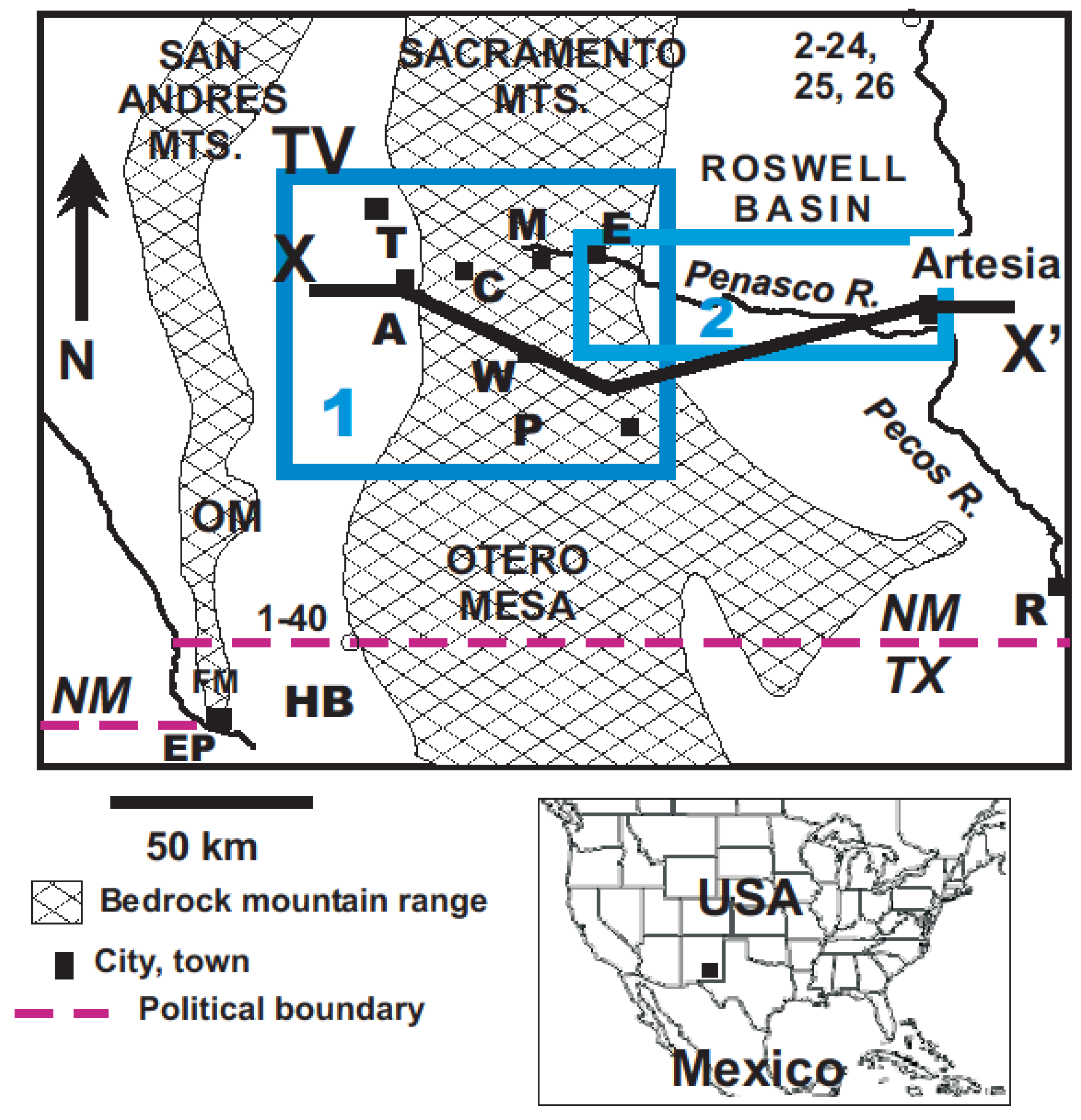
2.1. Topography, Climate and Vegetation
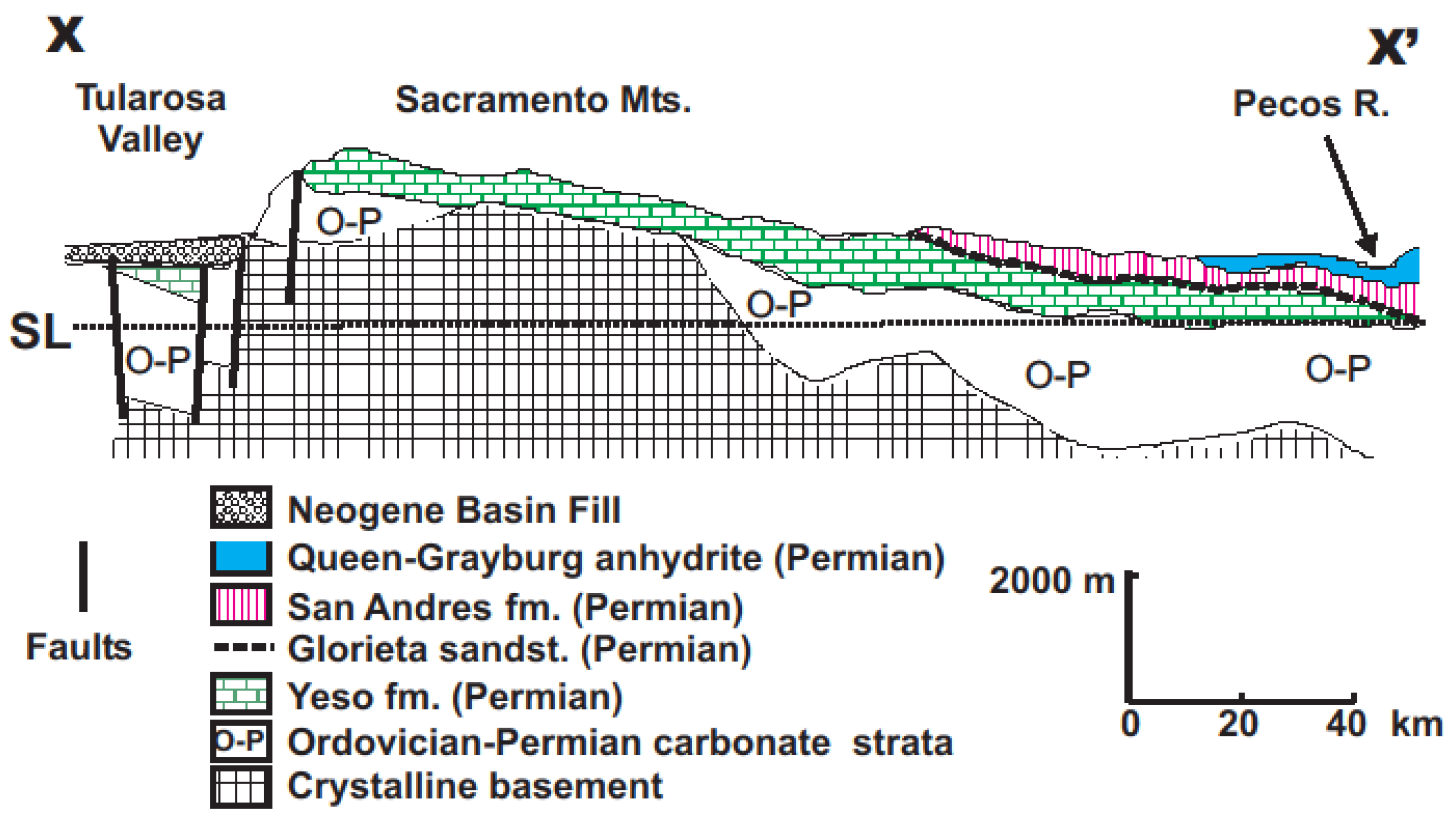
2.2. Geology
2.3. Geohydrology
2.4. Previous Isotope Studies
3. Methods
3.1. Analytical Methods
3.2. Correction of Raw Carbon-14 Data

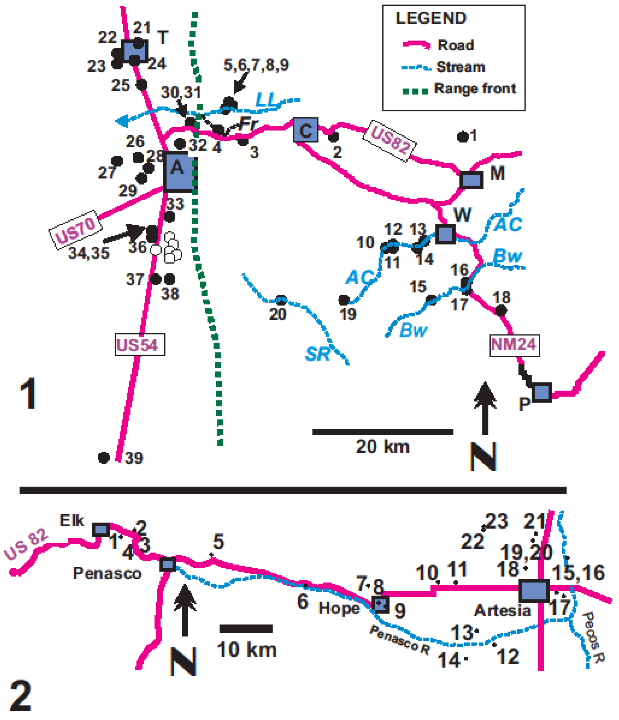
| Well | Site name (Group) | Lat | Long | Site altitude | Date | Well depth | SWL | δ18O | δD | δ34S | δ13C DIC | Tritium | C-14 | Corrected age |
|---|---|---|---|---|---|---|---|---|---|---|---|---|---|---|
| m.a.s.l. | m | m.a.s.l. | ‰ | ‰ | ‰ | ‰ | TU | pMC | yrs BP | |||||
| Study area 1: high Sacramento Mountains | ||||||||||||||
| 1-1 | Fields (H2) | 32.959 | −105.525 | 2270 | 10 December 2003 | 121 | na | −7.9 | −53 | 12.1 | −8.2 | 0.5 | 82.0 | post-bomb |
| 1-2 | Cloudcroft well 4 (H1) | 32.9505 | −105.7019 | 2550 | 8 August 2003 | 164 | 2474.5 | −9.3 | −63 | 10.3 | −9.8 | 5.1 | 82.7 | post-bomb |
| 1-3 | Ehret (W) | 32.945 | −105.8405 | 2007 | 9 August 2003 | 206 | 1861.5 | −9.9 | −71 | |||||
| 1-4 | Bearden (W) | 32.9601 | −105.8844 | 1627 | 10 August 2003 | 9 | na | −8.5 | −61 | 2.3 | ||||
| 1-5 | Macon (W) | 32.9951 | −105.8437 | 1900 | 9 August 2003 | 19 | 1886.0 | −9.7 | −66 | 12.3 | 2.4 | 78.5 | post-bomb | |
| 1-6 | Macon spring (W) | 32.9951 | −105.8437 | 1900 | 9 August 2003 | na | na | −9.5 | −66 | 2.5 | ||||
| 1-7 | Williams (W) | 32.9905 | −105.894 | 1624 | 9 August 2003 | 16 | na | −9.6 | −66 | 12.3 | 1.3 | 72.6 | post-bomb | |
| 1-8 | Warnock (W) | 32.9892 | −105.8474 | 1820 | 8 August 2003 | 90 | 1793.6 | −9.9 | −66 | 12.2 | 1.7 | 72.5 | post-bomb | |
| 1-9 | Sect. 22 Water Assoc.Spr. (W) | 32.991 | −105.871 | 1760 | 9 August 2003 | −9.6 | −66 | A 0.5 | ||||||
| 1-10 | Posey spring (H1) | 32.793 | −105.5779 | 2450 | 7 December 2003 | −9.3 | −64 | 9.0 | −10.2 | 5.7 | 95.0 | post-bomb | ||
| 1-11 | Sky Ridge (H1) | 32.792 | −105.5672 | 2350 | 7 December 2003 | na | na | −9.6 | −65 | |||||
| 1-12 | Sky Ridge spring (H1) | 32.794 | −105.5783 | 2355 | 7 December 2003 | −9.4 | −64 | −9.7 | ||||||
| 1-13 | Scott (H2) | 32.798 | −105.5521 | 2230 | 7 December 2003 | 48 | na | −8.1 | −57 | −9.4 | ||||
| 1-14 | Sac. Methodist Academy (H2) | 32.794 | −105.558 | 2240 | 7 December 2003 | na | na | −8.6 | −60 | −9.9 | 0.7 | |||
| 1-15 | Essek (H1) | 32.716 | −105.5305 | 2225 | 7 December 2003 | 273 | na | −10.2 | −69 | 13.0 | −4.3 | 2.0 | 22.1 | 2,000–4,500 |
| 1-16 | Wright (H2) | 32.7414 | −105.4793 | 2075 | 9 December 2003 | na | na | −8.1 | 2.9 | |||||
| 1-17 | Bell (H2) | 32.7414 | −105.4793 | 2075 | 8 December 2003 | na | na | −8.2 | −57 | |||||
| 1-18 | Stewart (H2) | 32.6953 | −105.4219 | 2035 | 8 December 2003 | 252 | na | −8.1 | −57 | 12.2 | −7.4 | 0.6 | 44.3 | 1,800–2,800 |
| 1-19 | Sand spring (H1) | 32.713 | −105.684 | 2600 | 7 December 2003 | −10.0 | −68 | −9.5 | ||||||
| 1-20 | Apple Tree Canyon spring (H1) | 32.713 | −105.747 | 2380 | 7 December 2003 | −9.9 | −66 | 12.1 | −10.1 | 6.2 | 92.8 | post-bomb | ||
| Study area 1: Alamogordo and Tularosa | ||||||||||||||
| 1-21 | Abercrombie | 33.091 | −106.015 | 1380 | 25 January 2005 | 91 | 1330.0 | −8.5 | −59 | 2.1 | ||||
| 1-22 | Cates | 33.075 | −106.045 | 1347 | 25 January 2005 | na | na | −10.5 | −67 | −8.1 | 84.4 | post-bomb | ||
| 1-23 | Hornback | 33.062 | −106.063 | 1326 | 25 January 2005 | 42 | 1305.4 | −8.2 | −59 | −8.1 | 2.0 | 79.7 | post-bomb | |
| 1-24 | Cinert | 33.040 | −106.011 | 1357 | 25 January 2005 | na | na | −8.4 | −59 | −4.6 | 1.2 | 36.5 | post-bomb | |
| 1-25 | McGinn | 32.99 | −105.99 | 1360 | 25 January 2005 | 56 | na | −9.1 | −63 | |||||
| 1-26 | Dyer | 32.9157 | −105.9864 | 1319 | 8 August 2003 | 58 | 1291.7 | −8.9 | −62 | 12.6 | 3.3 | |||
| 1-27 | McDonald | 32.9009 | −106.0069 | 1299 | 8 August 2003 | 91 | 1279.3 | −8.9 | −62 | 12.1 | −6.0 | 1.2 | ||
| 1-28 | Dellacorino | 32.90 | −105.96 | 1326 | 25 January 2005 | 96 | na | −9.1 | −63 | |||||
| 1-29 | Noriega | 32.8954 | −105.9885 | 1303 | 9 August 2003 | 30 | na | −8.9 | −62 | −6.3 | 3.9 | 53.6 | post-bomb | |
| 1-30 | City of Alamogordo well 2 | 32.9681 | −105.9369 | 1440 | September 2003 | na | na | −8.9 | −63 | −6.0 | 1.3 | 50.6 | post-bomb | |
| 1-31 | City of Alamogordo well 8 | 32.9681 | −105.9369 | 1440 | September 2003 | na | na | −9.0 | −63 | |||||
| 1-32 | Harrington | 32.9462 | −105.9469 | 1402 | 8 August 2003 | 121 | na | −9.1 | −63 | 12.6 | 1.6 | |||
| 1-33 | Moore | 32.83 | −105.96 | 1294 | 8 August 2003 | 61 | 1259.0 | −9.3 | −64 | 11.2 | −6.0 | <0.5 | 39.8 | 500–2,200 |
| 1-34 | Boyle | 32.81 | −105.99 | 1253 | 25 January 2005 | 46 | 1234.8 | −9.5 | −66 | A 0.5 | ||||
| 1-35 | Harrell | 32.81 | −105.99 | 1253 | 25 January 2005 | 61 | 1233.3 | −9.4 | −65 | |||||
| 1-36 | Baca | 32.81 | −105.99 | 1253 | 25 January 2005 | 76 | 1239.4 | −9.2 | −64 | |||||
| 1-37 | Mount | 32.74 | −105.97 | 1234 | 25 January 2005 | 52 | −9.0 | −63 | ||||||
| 1-38 | Wisdom | 32.744 | −105.966 | 1237 | 25 January 2005 | 49 | 1203.1 | −9.2 | −64 | |||||
| Southeastern Tularosa Valley | ||||||||||||||
| 1-39 | Otero County landfill | 32.562 | −106.025 | 1230 | 22 March 2004 | na | na | −8.9 | −69 | −3.8 | <0.6 | 2.9 | 17,850–21,000 | |
| 1-40 | El Paso WU Brine injection site | 31.973 | −106.106 | 1269 | early 2007 | na | na | −9.5 | −71 | −1.8 | <0.4 | 2.8 | 12,100–18,500 | |
| 1-40 | El Paso WU Brine injection site | 31.973 | −106.106 | 1269 | early 2008 | na | na | −9.5 | −70 | |||||
| Study area 2 | ||||||||||||||
| 2-1 | Unnamed spring | 32.931 | −105.282 | 1750 | July 2006 | −7.9 | −55 | |||||||
| 2-2 | J. Powell windmill | 32.955 | −105.277 | 1758 | July 2006 | 73 | 1694.0 | −7.9 | −55 | −8.9 | 1.8 | 75.2 | post-bomb | |
| 2-3 | J. Powell well | 32.979 | −105.248 | 1748 | July 2006 | 24 | 1732.8 | −8.3 | −58 | 12.3 | 1.5 | |||
| 2-4 | H. Powell | 32.921 | −105.252 | 1740 | July 2006 | 33 | 1709.5 | −8.4 | −58 | |||||
| 2-5 | Orton | 32.892 | −105.08 | 1602 | July 2006 | 259 | 1419.1 | −8.1 | −56 | 13.8 | −8.8 | 1.0 | 57.5 | 900–1600 |
| 2-6 | Duncan | 32.845 | −104.892 | 1380 | July 2006 | na | na | −8.3 | −56 | 12.4 | ||||
| 2-7 | Young | 32.840 | −104.773 | 1277 | July 2006 | na | 1086.5 | −7.9 | −55 | <0.7 | ||||
| 2-8 | Hope Water Co. | 32.810 | −104.734 | 1250 | July 2006 | na | na | −8.3 | −58 | |||||
| 2-9 | Bannon | 32.783 | −104.713 | 1042 | July 2006 | 195 | 875.3 | −8.3 | −57 | −6.7 | <0.7 | 29.2 | 4,400–5,600 | |
| 2-10 | Jones | 32.847 | −104.613 | 1060 | July 2006 | na | 999.0 | −8.1 | −54 | 14.3 | ||||
| 2-11 | Lamb | 32.843 | −104.568 | 1035 | July 2006 | na | na | −8.3 | −57 | −5.9 | <0.6 | 29.9 | 2,600–4,000 | |
| 2-12 | Brown 1 D | 32.741 | −104.496 | 1085 | July 2006 | 130 | 1021.0 | −8.3 | −58 | |||||
| 2-13 | Brown 2 D | 32.764 | −104.534 | 1085 | July 2006 | 130 | na | −7.1 | −51 | |||||
| 2-14 | Brown 3 D | 32.712 | −104.552 | 1085 | July 2006 | na | na | −8.1 | −57 | |||||
| 2-15 | Joy 1 S | 32.833 | −104.378 | 1020 | July 2006 | 81 | 1000.2 | −7.9 | −54 | 13.0 | ||||
| 2-16 | Joy 2 D | 32.834 | −104.368 | 1020 | July 2006 | 290 | na | −8.3 | −57 | 13.2 | <0.5 | |||
| 2-17 | Pardue S | 32.820 | −104.362 | 1015 | July 2006 | 61 | 954.0 | −8.1 | −55 | |||||
| 2-18 | Rodney S | 32.882 | −104.424 | 1045 | July 2006 | 64 | 990.1 | −7.8 | −55 | |||||
| 2-19 | Mayberry 3 S | 32.925 | −104.412 | 1032 | July 2006 | 61 | 1000.0 | −7.2 | −51 | 12.8 | 1.3 | |||
| 2-20 | Mayberry 4 D | 32.925 | −104.412 | 1032 | July 2006 | 304 | na | −8.4 | −58 | 13.4 | ||||
| 2-21 | Mayberry 2 D | 32.937 | −104.412 | 1030 | July 2006 | 304 | 975.1 | −8.2 | −56 | 13.8 | −6.1 | 0.5 | 33.7 | 1,350–3,000 |
| 2-22 | Mayberry 1 D | 32.963 | −104.509 | 1070 | July 2006 | 274 | na | −8.3 | −58 | 13.4 | −5.4 | 35.6 | ||
| 2-23 | Menefee D | 32.970 | −104.508 | 1072 | July 2006 | 274 | 1044.6 | −8.2 | −57 | 13.1 | ||||
| Roswell | ||||||||||||||
| 2-24 | Hatfield N well | 33.574 | −104.482 | 1105 | May 2007 | na | na | −6.6 | −49 | |||||
| 2-25 | Hatfield E well | 33.572 | −104.479 | 1104 | May 2007 | na | na | −7.6 | −53 | |||||
| 2-26 | Hatfield artesian | 33.574 | −104.483 | 1104 | May 2007 | na | na | −8.4 | −56 | |||||
| Surface Water | 32.887 | −105.186 | 1730 | July 2006 | −8.4 | −57 | 12.7 | |||||||
| Rio Penasco | 32.886 | −104.344 | 1010 | July 2006 | −3.3 | −34 | 12.2 | |||||||
| Pecos river | 32.886 | −104.344 | 1010 | December 2006 | −6.5 | −49 | ||||||||
| Pecos R. | 33.209 | −104.395 | 1041 | December 2006 | −6.7 | −51 | ||||||||
| Pecos R. | 33.382 | −104.404 | 1056 | May 2007 | −2.7 | −35 | ||||||||
| Pecos R. | ||||||||||||||
| Precipitation | ||||||||||||||
| 1-8 | 32.9892 | −105.8474 | August 2003 | −6.4 | −47 | 4.6 | ||||||||
| 1-16 | 32.7414 | −105.4793 | 2075 | August–October 2003 | −10.4 | −70 | 4.7 | |||||||
| 1-16 | 32.7414 | −105.4793 | 2075 | March 2004 | −8.2 | −54 | 7.4 | |||||||
| 1-13 | 32.798 | −105.5521 | 2230 | August–September 2003 | −6.8 | −57 | 3.9 | |||||||
4. Area 1: High Sacramento Mountains
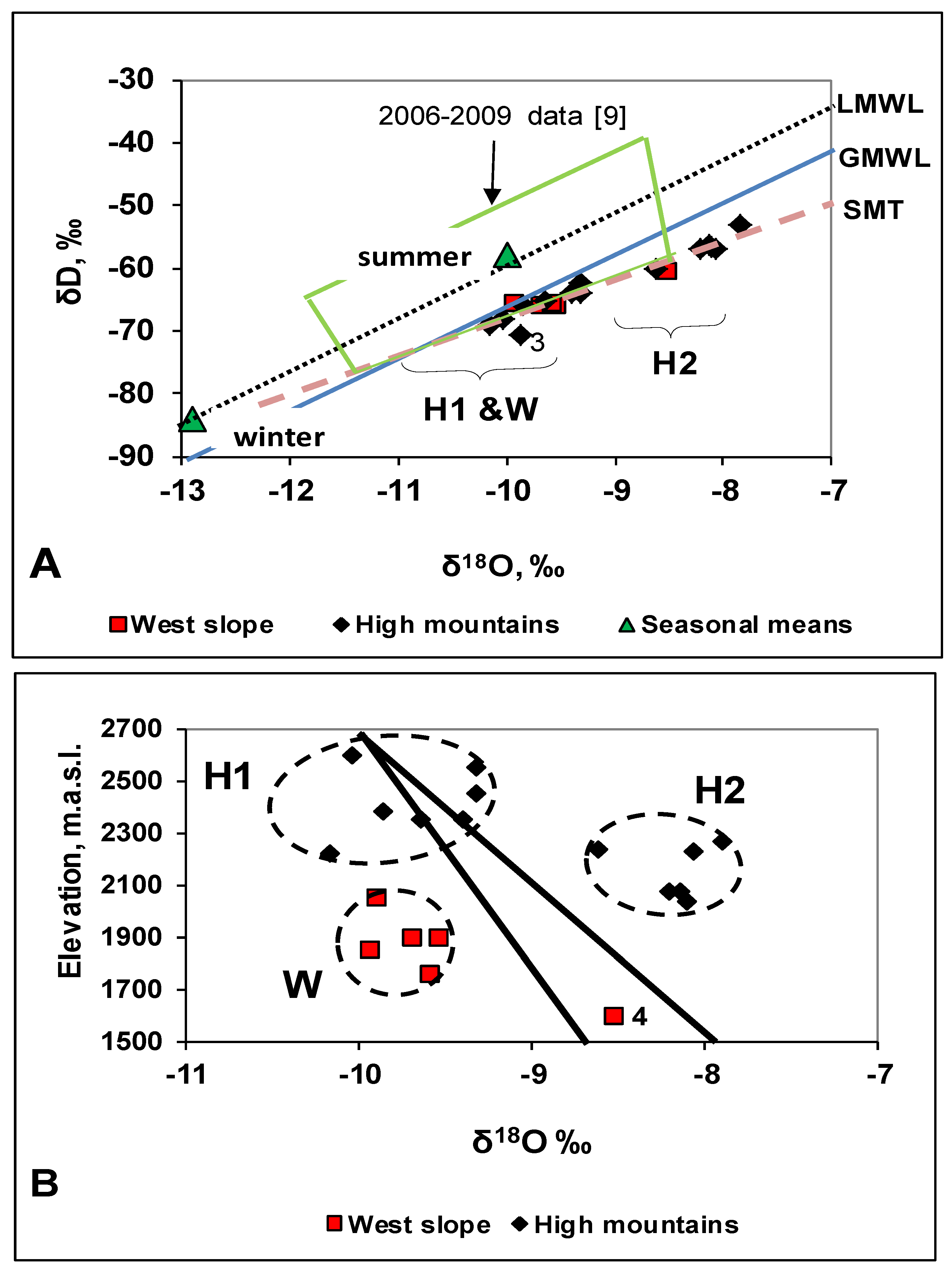
4.1. O and H Isotopes
4.2. Other Parameters
4.3. Interpretation
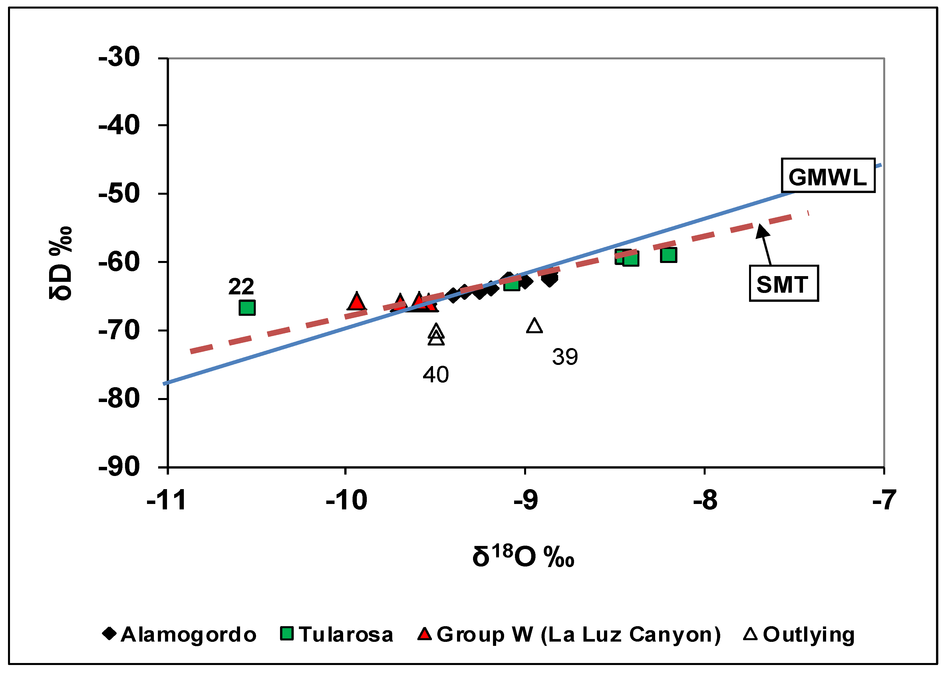
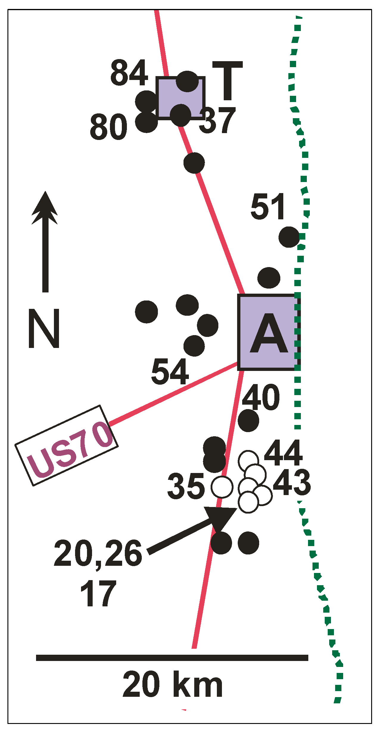
5. Area 1—Alamogordo and Tularosa
5.1. O and H Isotopes
5.2. Other Parameters
5.3. Interpretation
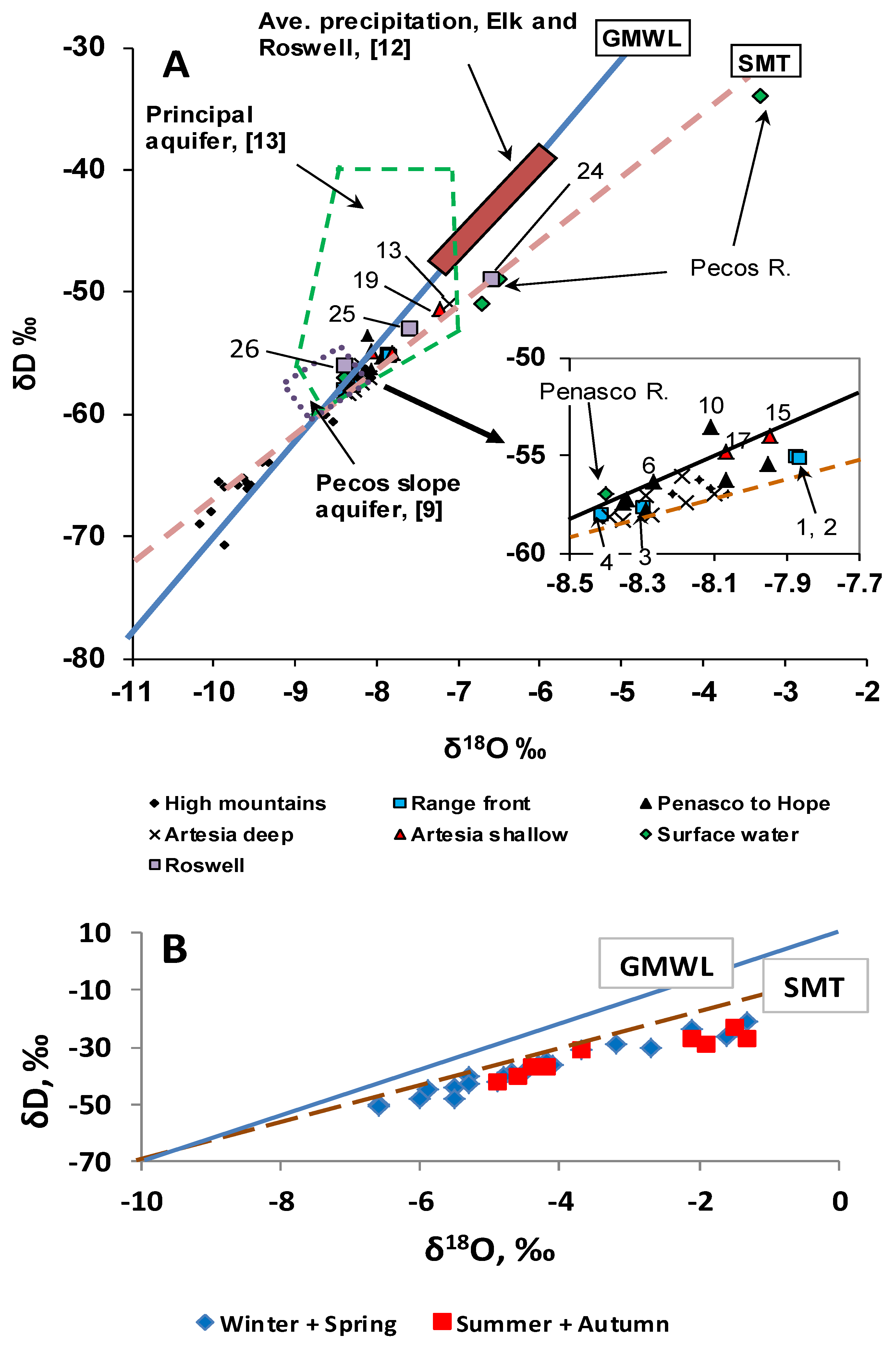
6. Area 2: Peñasco to Artesia
6.1. O and H Isotopes
6.2. Tritium

6.3. Other Parameters
6.4. Interpretation
7. Discussion
7.1. Water Sources in Study Area
7.2. Seasonality of Recharge
7.3. Sacramento Mountain Carbonate Strata as a Karst Aquifer
7.4. Mode of Mountain-Front Recharge to Basin Alluvium
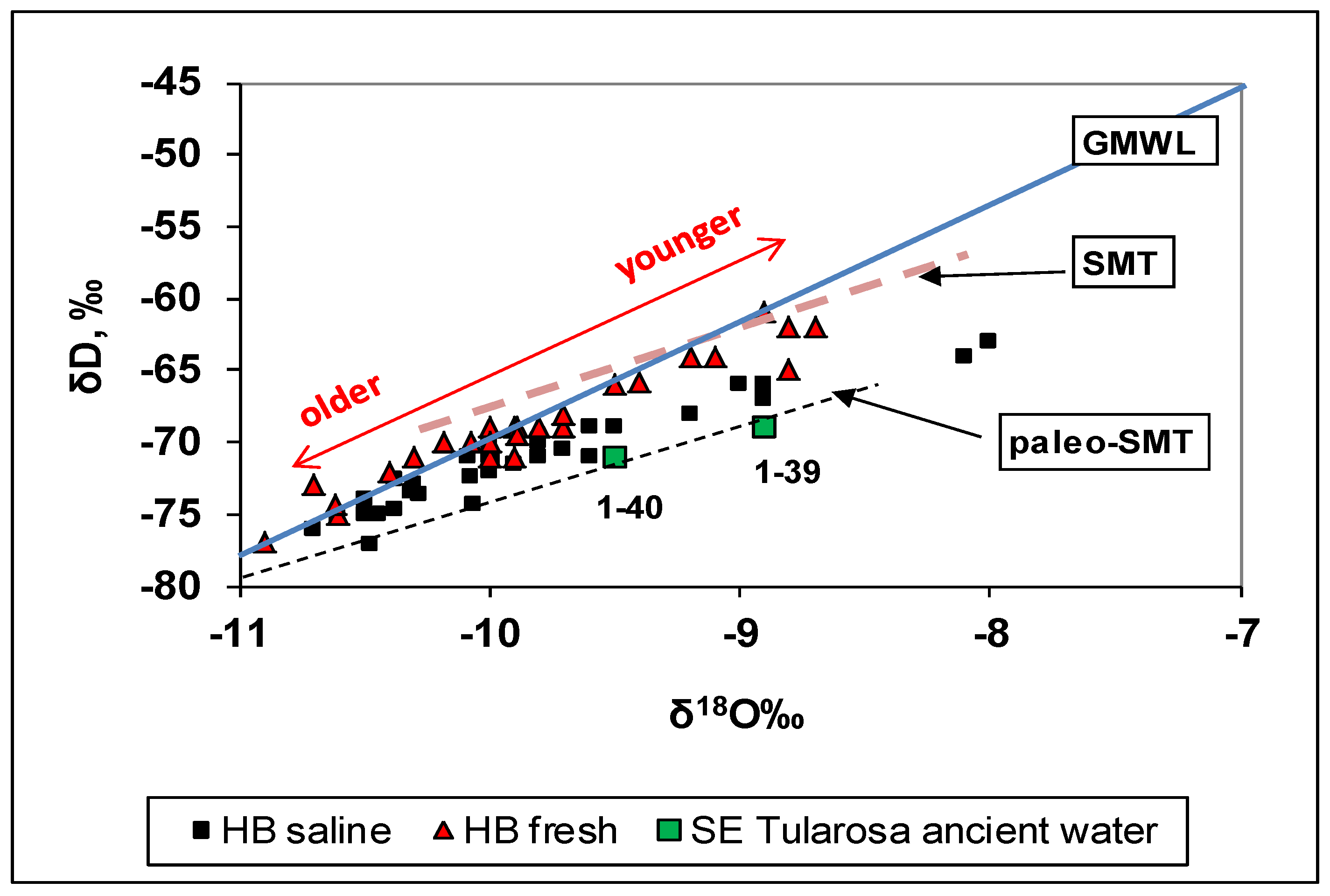
7.5. Source of Hueco Bolson Groundwater
7.6. Implications for Groundwater Management
8. Conclusions
Acknowledgements
Conflicts of Interest
References
- Eastoe, C.J.; Gu, A.; Long, A. The Origins, Ages and Flow Paths of Groundwater in Tucson Basin: Results of a Study of Multiple Isotope Systems. In Groundwater Recharge in a Desert Environment: The Southwestern United States; Water Science and Applications Series; Hogan, J.F., Phillips, F.M., Scanlon, B.R., Eds.; American Geophysical Union: Washington, DC, USA, 2004; Volume 9, pp. 217–234. [Google Scholar]
- Eastoe, C.J.; Hibbs, B.J.; Olivas, A.G.; Hogan, J.; Hawley, J.; Hutchison, W.R. Isotopes in the Hueco Bolson Aquifer, Texas (USA) and Chihuahua (Mexico): Local and general implications for recharge sources in alluvial basins. Hydrogeol. J. 2008, 16, 737–747. [Google Scholar] [CrossRef]
- Eastoe, C.J.; Hutchison, W.R.; Hibbs, B.J.; Hawley, J.; Hogan, J.F. Interaction of a river with an alluvial basin aquifer: Stable isotopes, salinity and water budgets. J. Hydrol. 2010, 395, 67–78. [Google Scholar] [CrossRef]
- Meinzer, O.E.; Hare, F.R. Geology and Water Resources of Tularosa Basin, New Mexico; U.S. Geological Survey Water-Supply Paper 343, U.S. Government Printing Office: Washington, DC, USA, 1915; p. 317. [Google Scholar]
- Huff, G.F. Simulation of Ground-Water Flow in the Basin-Fill Aquifer of the Tularosa Basin, South-Central New Mexico, Predevelopment through 2040; Scientific Investigations Report; U.S. Geological Survey: Reston, VA, USA, 2005; pp. 2004–5197.
- Hibbs, B.J.; Boghici, R.N.; Hayes, M.E.; Ashworth, J.B.; Hanson, A.N.; Samani, Z.A.; Kennedy, J.F.; Creel, R.J. Transboundary Aquifers of the El Paso/Ciudad Juarez/Las Cruces Region; Contract Report; Texas Water Development Board, Austin & New Mexico Water Resources Research Institute: Las Cruces, NM, USA, 1997; p. 148. [Google Scholar]
- Mayer, J.R.; Sharp, J.M., Jr. Fracture control of regional groundwater flow in a carbonate aquifer in a semi-arid region. Geol. Soc. Am. Bull. 1998, 110, 1657–1671. [Google Scholar]
- National Oceanic and Atmospheric Administration. Climatography of the United States No. 81, Monthly Normals of Temperature, Precipitation and Heating and Cooling Degree Days, 1971–2000. Available online: http://cdo.ncdc.noaa.gov/climatenormals/clim81/NMnorm.pdf (accessed on 15 January 2013).
- Newton, T.B.; Rawling, G.C.; Timmons, S.S.; Land, L.; Johnson, P.S.; Kludt, T.J.; Timmons, J.M. Sacramento Mountains Hydrogeology Study; New Mexico Bureau of Geology and Mineral Resources Open-File Report 543; New Mexico Bureau of Geology and Mineral Resources: Socorro, NM, USA, 2012; p. 78. [Google Scholar]
- Roswell Geological Society, Stratigraphic Research Committee. West-East Correlation Section, San Andres Mts. to N.Mex.-Texas Line, Southeastern New Mexico; Roswell Geological Society: Roswell, NM, USA, 1956. [Google Scholar]
- Havenor, K.C. The Hydrogeologic Framework of the Roswell Groundwater Basin, Chaves, Eddy, Lincoln, and Otero Counties, New Mexico. Ph.D. Thesis, University of Arizona, Tucson, AZ, USA, 1996. [Google Scholar]
- Gross, G.W.; Hoy, R.N.; Duffy, C.J.; Rehfeldt, K.R. Isotope Studies of Recharge in Roswell Basin. In Isotope Studies in Hydrologic Processes; Perry, E.C., Jr., Montgomery, C.W., Eds.; Northern Illinois University Press: DeKalb, IL, USA, 1982; pp. 25–33. [Google Scholar]
- Hoy, R.N.; Gross, G.W. A Baseline Study of Oxygen 18 and Deuterium in the Roswell, New Mexico, Groundwater Basin; New Mexico Water Resources Research Institute: Las Cruces, NM, USA, 1982; Volume 144, p. 98. [Google Scholar]
- Yuan, F.; Miyamoto, S. Characteristics of oxygen-18 and deuterium composition in waters from the Pecos River in American Southwest. Chem. Geol. 2008, 255, 220–230. [Google Scholar] [CrossRef]
- Coplen, T.B.; Kendall, C. Stable Oxygen and Hydrogen Isotope Ratios for Selected Sites of the U.S. Geological Survey’s NASQAN and Benchmark Surface Water Networks; U.S. Geological Survey Open-File Report 00-160; U.S. Geological Survey: Reston, VA, USA, 2000; p. 409.
- Szynkiewicz, A.; Newton, B.T.; Timmons, S.S.; Borrok, D.M. The sources and budget for dissolved sulfate in a fractured carbonate aquifer, Southern Sacramento Mountains, New Mexico, USA. Appl. Geochem. 2012, 27, 1451–1462. [Google Scholar] [CrossRef]
- Huff, G.F. Apparent Age of Ground Water Near the Southeastern Margin of the Tularosa Basin, Otero County, New Mexico. In Geology of White Sands: New Mexico Geological Society Guidebook; Giles, K.A., Lueth, V.W., Lucas, S.G., Kues, B.S., Myers, R., Ulmer-Scholle, D.S., Eds.; New Mexico Geological Society: Alamogordo, NM, USA, 2002; Volume 53, pp. 303–307. [Google Scholar]
- Clark, I.; Fritz, P. Environmental Isotopes in Hydrogeology; Lewis Publishers: Boca Raton, FL, USA, 1997; p. 328. [Google Scholar]
- Veizer, J.; Hoefs, J. The nature of 18O/16O and 13C/12C secular trends in sedimentary carbonate rocks. Geochim. Cosmochim. Acta 1976, 40, 1387–1395. [Google Scholar] [CrossRef]
- Colgan, R.E.; Scholle, P.A. Carbon isotopic stratigraphy of the San Andres Formation; A possible correlation tool? (Abstract). Am. Assoc. Pet. Geologists Bull. 1991, 75, 555. [Google Scholar]
- Wright, W.E. δD and δ18O in Mixed Conifer Systems in the U.S. Southwest: The Potential of δ18O in Pinus Ponderosa Tree Rings as a Natural Environmental Recorder. Ph.D. Thesis, Department of Geosciences, The University of Arizona, Tucson, AZ, USA, 2001. [Google Scholar]
- Eastoe, C.J.; Watts, C.J.; Ploughe, M.; Wright, W.E. Future use of tritium in mapping pre-bomb groundwater volumes. Ground Water 2011, 50, 87–93. [Google Scholar]
- Winograd, I.J.; Riggs, A.C.; Coplen, T.B. The relative contributions of summer and cool-season precipitation to groundwater recharge, Spring Mountains, Nevada, USA. Hydrogeol. J. 1998, 6, 77–93. [Google Scholar] [CrossRef]
- Wahi, A.K.; Hogan, J.F.; Ekwurzel, B.; Baillie, M.N.; Eastoe, C.J. Geochemical quantification of semiarid mountain recharge. Ground Water 2008, 46, 414–425. [Google Scholar] [CrossRef]
- Cunningham, E.E.B.; Long, A.; Eastoe, C.J.; Bassett, R.L. Migration of recharge waters downgradient from the Santa Catalina Mountains into the Tucson Basin aquifer. Hydrogeol. J. 1998, 6, 94–103. [Google Scholar] [CrossRef]
- Blasch, K.W.; Bryson, J.R. Distinguishing sources of ground water recharge by using δ2H and δ18O. Ground Water 2007, 45, 294–308. [Google Scholar] [CrossRef]
- Worthington, S.R.H.; Ford, D.C. Self-organized permeability in carbonate aquifers. Ground Water 2009, 47, 326–336. [Google Scholar] [CrossRef]
- Uliana, M.M.; Sharp, J.M. Tracing regional flow paths to major springs in Trans-Pecos Texas using geochemical data and geochemical models. Chem. Geol. 2001, 179, 53–72. [Google Scholar] [CrossRef]
- Wolaver, B.D.; Sharp, J.M.; Rodriguez, J.M.; Ibarra, F. Delineation of regional karstic aquifers: An integrative data approach. Ground Water 2008, 46, 396–413. [Google Scholar] [CrossRef]
- Plummer, L.N.; Bexfield, L.M.; Anderholm, S.K.; Sanford, W.E.; Busenberg, E. Geochemical Characterization of Ground-Water Flow in the Santa Fe Group Aquifer System, Middle Rio Grande Basin, New Mexico; U.S.G.S. Water-Resources Investigation Report 03-4131; U.S. Geological Survey: Reston, VA, USA, 2004; pp. 1–395.
- Druhan, J.L.; Hogan, J.F.; Eastoe, C.J.; Hibbs, B.; Hutchison, W.R. Hydrogeologic controls on groundwater recharge and salinization: A geochemical analysis of the Northern Hueco Bolson Aquifer, El Paso, Texas. Hydrogeol. J. 2008, 16, 281–296. [Google Scholar] [CrossRef]
© 2014 by the authors; licensee MDPI, Basel, Switzerland. This article is an open access article distributed under the terms and conditions of the Creative Commons Attribution license (http://creativecommons.org/licenses/by/3.0/).
Share and Cite
Eastoe, C.J.; Rodney, R. Isotopes as Tracers of Water Origin in and Near a Regional Carbonate Aquifer: The Southern Sacramento Mountains, New Mexico. Water 2014, 6, 301-323. https://doi.org/10.3390/w6020301
Eastoe CJ, Rodney R. Isotopes as Tracers of Water Origin in and Near a Regional Carbonate Aquifer: The Southern Sacramento Mountains, New Mexico. Water. 2014; 6(2):301-323. https://doi.org/10.3390/w6020301
Chicago/Turabian StyleEastoe, Christopher J., and Ryan Rodney. 2014. "Isotopes as Tracers of Water Origin in and Near a Regional Carbonate Aquifer: The Southern Sacramento Mountains, New Mexico" Water 6, no. 2: 301-323. https://doi.org/10.3390/w6020301
APA StyleEastoe, C. J., & Rodney, R. (2014). Isotopes as Tracers of Water Origin in and Near a Regional Carbonate Aquifer: The Southern Sacramento Mountains, New Mexico. Water, 6(2), 301-323. https://doi.org/10.3390/w6020301