The empirical exercise described below attempts to get a broad understanding of the magnitude of economic gains and losses consequent to the reform of the legislative framework on groundwater use rights. The exercise consists of comparing the situation before and after the reform. However it is worth mentioning that in order to complete an eventual reform on such a sensitive matter, a long process of politic discussion and public involvement is necessary, and may also induce legal actions of some affected parties against the State. All these aspects obviously will imply some highly relevant costs, in terms of time for discussion and voting, as well as private and public costs to cover legal fees and trial costs.
In addition, this analysis is focused only on the current effects on irrigated agriculture, given that in the South of Italy, similar to other arid and semi-arid regions, irrigation is the economic activity exerting the highest pressure on groundwater sources. Although irrigated agriculture is undoubtedly profitable and also plays a strategic role for industrial food chains (e.g., processed tomato, wine, olive oil), the need for a sustainable approach is acknowledged, since groundwater extraction affects the profitability of neighbor users, the depletion of the resource, and the endowments for future generations.
3.1. Data Collection
Technical data. The case study refers to a flat area served by irrigation infrastructures of pipelines conveying pressured water, managed by the local irrigation board called ‘Consorzio per la Bonifica della Capitanata’ (CBC) (see
Figure 1). The irrigation project was completed in the 1960s and converted traditional rain fed agriculture based on pastures and winter cereals, in more intensive agriculture, that was also stimulating the demand for additional water sources. Indeed private wells have been largely drilled without strict control from the public authority. Their distribution has been also affected by the water accessibility to the CBC, which still represents the most convenient and low-cost water source. For this reason, groundwater is often a complementary source either to enlarge the irrigated area, and also to guarantee the availability of irrigation in case of water shortage from the CBC, which depends on the rainfall patterns in the autumn and winter [
19]. The percentage of water from CBC and groundwater from private wells annually varies according to the CBC availability. Usually the share amounts to 50% between the two sources, but during exceptionally long drought periods the groundwater can reach 100% of irrigation water [
19].
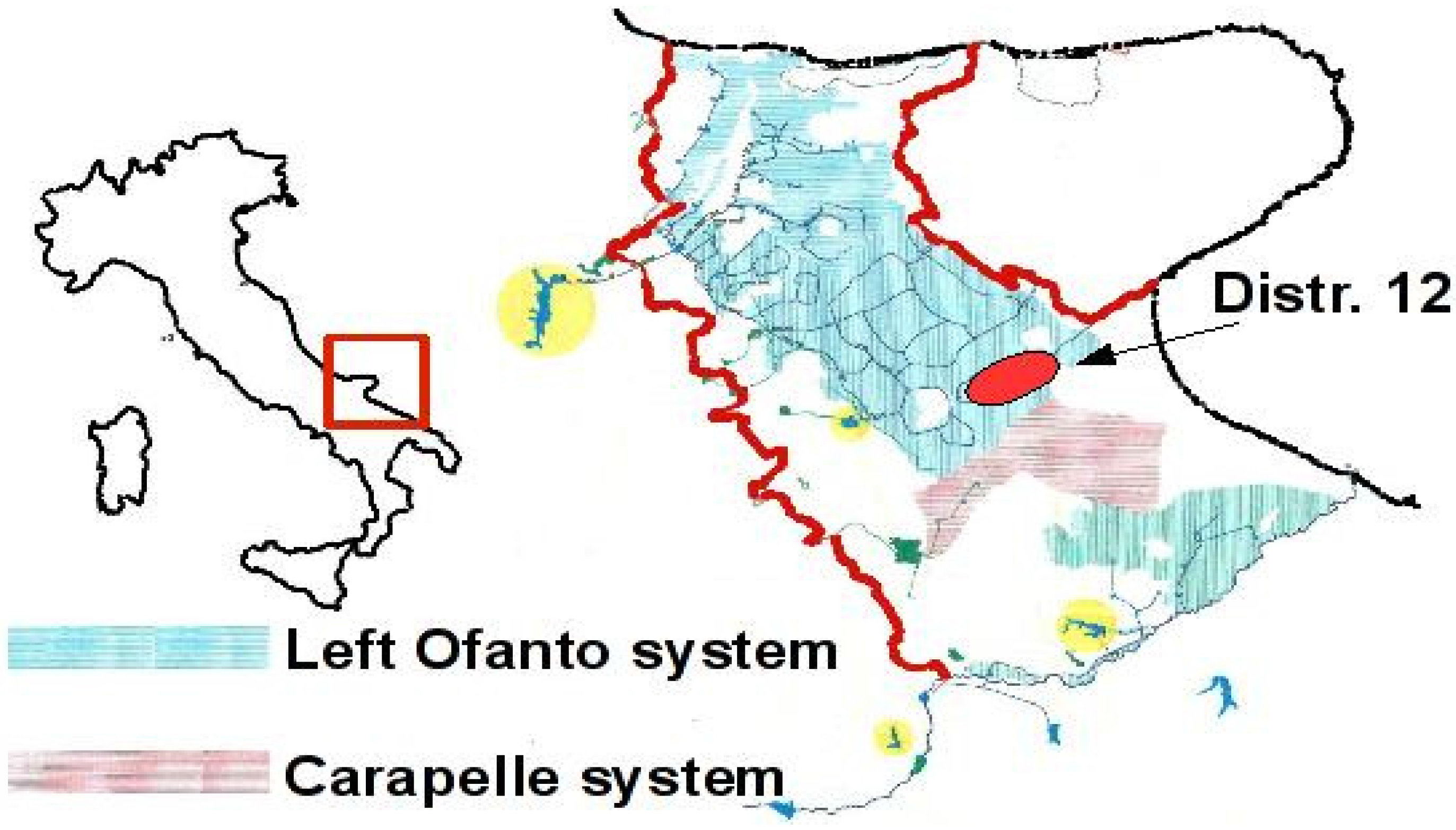
Figure 1.
The study area (Apulia region, Foggia province). The faded area is served by the CBC.
Figure 1.
The study area (Apulia region, Foggia province). The faded area is served by the CBC.
Although the overall irrigation infrastructure covers about 135,000 ha, the economic analysis refers to a representative area (the District 12) of 11,300 ha, devoted to wheat, tomato for the processing industry, and some other horticulture crops (e.g., asparagus, artichoke, cabbage). The yearly amount of water conveyed by the CBC amounts to 10 million cubic meters, and an equivalent amount is estimated to be extracted from private wells.
The farming structure consists of 1,198 farms, with the average size ranging from 10 to 43 ha. According to a previous study conducted on the same area, five farm typologies can be shaped by means of a cluster analysis: (
i) small and part-time family farms; (
ii) medium size farms with cereals and intensive horticultural crops; (
iii) large size farms with cereals and intensive horticultural crops; (
iv) average size farms with cereals, intensive horticultural crops and orchards; and (
v) large size corporation farm. They mostly differ in terms of crop rotations, intensity of land renting and monthly hired and family work load (more details are available in [
20]).
In order to simplify the empirical exercise, we selected only the two main types of farms, representing 82% of the operating farms, and 72% of the cultivated land.
As reported in
Table 1, the first type is the common irrigated farm, where irrigated crops play a relevant role (tomato and other horticultural crops covering respectively 19% and 21% of the farmland). The second type is relatively less intensive, with larger farmland size, and relatively more simplified cropping patterns based on rain fed cereals and irrigated tomato.
Table 1.
Descriptive data of the two farm types.
Table 1.
Descriptive data of the two farm types.
| | Type 1 (intensive) | Type 2 (less intensive) |
|---|
| Total farmland (ha) | 1,686 | 8,218 |
| Operating farms (number) | 180 | 805 |
| Farm size (ha) | 22 | 43 |
| Share of irrigated land (%) | 45 | 28 |
| Specific water consumption (m3/ha) | 1,672 | 2,579 |
| Cropping patterns: | | |
| winter cereals (mainly durum wheat) (%) | 50 | 70,00 |
| tomato for processing industry (%) | 19 | 18 |
| horticultural crops (%) | 21 | 7 |
| orchards (olive and vineyard) (%) | 10 | 5 |
Defining the current situation of use rights (status-quo). At present, there are two main water irrigation sources: water conveyed by the CBC and groundwater from private wells.
Although the CBC is a private consortium of landowners, it is empowered by the public authority (the Apulia Region) to manage the water from the reservoir called ‘Occhito’, located in the mountainous area of the province of Foggia. Landowners have received water use rights by a system coupled with their own land, for an overall amount of water rights which is proportional to the land served by the infrastructure. The use rights are strictly linked with the land and depend on the presence of infrastructures, and cannot be sold separately (neither temporarily, nor permanently). The available amount of water supply varies according to the reservoir capacity, which depends on the rainfall during the previous year. Consequently, larger landowners take a revenue advantage, which becomes evident in terms of higher yields of irrigated crops, or higher market values.
The CBC adopts volumetric increasing block tariffs, and therefore farmers pay accordingly with their actual consumption. In more detail, during the year 2007, a three-tiered pricing has been applied, with a first block of 2,050 m
3/ha at a lower tariff (0.09 EUR/m
3), sufficient to cover their running costs, a second block of 950 m
3/ha, available at an intermediate tariff (0.12 EUR/m
3), and the exceeding amount at a higher tariff (0.24 EUR/m
3). This last tariff currently exceeds the water productivity of most farms, which is evaluated in terms of 0.18 EUR/m
3 [
20,
21].
In the case of the management of groundwater, the responsibility is upon the public authority, which is empowered to release extraction licenses to legitimated farmers (upon agreement with the landowner) for agricultural purposes and for a limited temporal horizon (30 years). However, the difficulties of performing an accurate monitoring over a relatively wide, scarcely populated area, has also favored the spreading of a high number of illegal drills. Today about 45,000 wells are estimated over the overall CBC served area [
22]. Furthermore, the public authority has collected data depicting a critical status of quality worsening, mostly due to the salinization process caused by the over-exploitation that have induced the infiltration of sea water [
23]. The Apulia Region has enacted the Regional Law n.9, of 21 May 2008, which introduces some changes in the procedure to get a groundwater right. Indeed, farmers are required to install measurement devices to record the amount extracted, as well as the periodical monitoring of the quality status, in terms of pollutants (e.g., nitrates and organic carbon) and salinization indicators. In order to exert an effective control on the volume extracted, a fixed allotment for each well has been determined. Furthermore, farmers are obliged to transmit data records to the public authority, and in the case of omission the authorization may be recalled. Finally, new permits (
i.e., access) are banned, until a complete monitoring of the current situation will be achieved. In this sense from an economic perspective, an advantage rent position arises in favor of farmers benefiting from the current authorization regime.
According to the current state of the average water consumption for the two farm types in the study area,
Table 2 reports the water availability either from the CBC and groundwater sources.
3.2. Specification of Alternative Use Right Settings
In order to proceed with the scenario formulation, three key factors that emerged from the literature analysis have been considered: (i) type of user allowed for participating in the market; (ii) resource access type; and (iii) possibility to sell (or re-sell) the use rights.
Table 2.
Current situation of groundwater use rights in the study area.
Table 2.
Current situation of groundwater use rights in the study area.
| Water source | Farm Type 1 (intensive) | Farm Type 2 (less intensive) |
|---|
| Access | Extraction (year 2007) | Sale | Access | Extraction (year 2007) | Sale |
|---|
| CBC | Proportional to the served land | 4,800 m3 | Forbidden | Proportional to the served land | 8,000 m3 | Forbidden |
| Groundwater | Historical record of extraction; banning of new authorizations | 5,000 m3 | Forbidden | Historical record of extraction; banning of new authorizations | 7,500 m3 | Forbidden |
Table 3.
Features of use rights scenarios.
Table 3.
Features of use rights scenarios.
| | Access right | Extraction right | Exchange right |
|---|
| Status-quo | Maintenance of the current authorized wells. Block of new authorizations | Volumetric allotment corresponding to historical records for each farm-type | Forbidden |
| Intra-sector market (A) | As status-quo | As status-quo | Temporary use right exchange allowed only among farmers |
| Regional market (B) | Free access to groundwater also to non-farmers, but subject to payment of volumetric tariffs | Overall extracted water at basin level, constrained up to historical records. Unconstrained use for single farmer | Forbidden |
As
Table 3 shows, the current scenario (
status-quo) depicts a situation in which the current users maintain their historical rights, while new authorization will not released. Farmer will not face any resource cost, except their private cost for water extraction from the ground. Finally, they are not allowed to sell water to other users.
In the case of the
Intra-sector Market (
A), farmers are allowed to sell their use rights only to other farmers. Since we are referring to an agricultural district where intensive farming is limited by water availability, the restriction of market participation seems reasonable and necessary to create a climate of trust in markets among farmers, which is an indispensable condition to activate the market [
24]. We assumed the absence of transaction costs, and free and complete information about water availability and price. According to the economic theory, the market would allow a more efficient allocation towards users capable of achieving higher groundwater productivity, with a consequent increase of agricultural wealth and farmers’ revenue.
In order to consider the opportunity to allow non-farmers groundwater access, we considered the Regional Market (B) scenario, where the public authority acts as a third party mediating agent, in order to prevent speculative actions and uneven access to the market. In this case, each participant may purchase use rights, regardless of the historical record. The public authority launches bidding calls at some determined level of pricing, to which farmers and non-farmers may participate. The level of the bid may also be conceived in terms of opportunity cost for water diversion for environmental uses, where the public authority acts to preserve the depletion of natural resources. Obviously, this scenario implies higher costs for farmers, but the removal of the historical constraints may allow the most efficient farmers to enlarge their irrigation operations, with a consequent increase in overall agricultural wealth and farmer’s income as well.
3.3. Economic Modeling
A mathematical programming model has been applied in order to simulate farmers’ decision making process under different groundwater use right settings. This kind of model is very frequent in the case of water allocation problems, due to the large heterogeneity of study areas, as well as the lack of data (either time series or cross sections) needed to adopt econometric models. In our case, we adopted a multi-agent territorial model, to simultaneously maximize the net return of the two types of farms, which are competing for the water resource available at basin level. Similar models have largely been reported in the scientific literature [
25,
26], and have also been applied to the Fortore river basin [
20,
27,
28]. The most remarkable difference with previous models consists of the fact that instead of calculating the aggregated farms’ revenue at basin level as the maximum sum of each farm’s revenue multiplied by the number of operating farms (
Max NR =
η Σ (
Farm’s revenue); in this case farm revenue is maximized for each farm type, and then we proceed with the weighted sum (Σ
η NR = (
Farms’s revenue)). In our opinion, this approach seems more logically consistent with what actually happens in the real world, where farmers interact with each other at single level, rather than at aggregated level. Consequently, the regional model specification of a farm pursuing its revenue maximization (
NR) under the current situation (
status-quo), is formally described by the following:
s.t.:
η Σ (x t ) ≤ T: land use availability of farm type j, for each season s is a constraint for the cultivation of the crop x;
η Σ (x Σ a ) ≤ W: irrigation water needs, depending on the specific water consumption a (m3/ha) of crop i, is constrained by the water availability W, deriving from source b, and available for farm type j;
η Σ (x l ) ≤ L: work load of type c (hours) needed by the crop i during the season s, is constrained by t the total labour availability L.
where:
η : weight representing the number of farm type j;
x : size of farmland (ha) devoted to the cultivation of the crop i, by farm type j;
t : seasonal farmland use (ha per season s), needed by the crop i, during season s;
T : farmland availability (ha), for season s and farm type j;
q , p : yields (t) and prices (EUR), of crop i;
mls : vector of production costs differences across farm types, due to economies of scale and different access to CAP subsidies, for crop i and farm type j (EUR/ha);
c , v : technical coefficients of input z (kg/ha), and its market price (EUR/kg);
a vw : specific water consumption for crop i, deriving for source b, and its tariff;
Fix : fixed costs faced by farm type j (EUR/farm), including insurance, maintenance, overheads, and taxes;
SFP : single farm payment, related to the EU CAP (EUR/farm);
WC : irrigation fixed cost, referred to farm type j (EUR).
In order to simulate the intra-sectoral market (A) the model has been modified by introducing a variable representing the exchanged water from one farm type to the other (w and w), leading to the equation (η Σ (x Σ a) ≤ w − w + W), provided that w and w can be positive or negative, but w − w = 0. This implies that farmers agree to a negotiated price (vw’), which determines a cost to farms purchasing water (vw’w) or a revenue to selling one (+vw’w). The mathematical model will calculate the best water allocation, by allowing a transaction of water rights from the farm type characterized by lower water productivity, to those having higher values. The conditions for water rights exchange will disappear when the values for water productivity of both farms will equalize: λw = λw = = λw for each n belonging to j. In this case, W may be conceived as the quota determined by the regulatory authority, in order to reduce the amount of water allocated to farmers, and therefore to save water for alternative uses.
With regard to the simulation of regional market (B), we eliminated the constraints representing the historical water uses (Σ (x Σ a ) ≤ W) from the status-quo model, and we substituted it with a more relaxed constraint (η Σ (x Σ a ) ≤ W). In addition, based on the assumption that the public authority acts as a third party mediating agent, it is supposed to start a bidding session, by defining a water tariff so that to clear the market or, alternatively, at a relatively higher tariff and that some water volumes are still available to be diverted to non-agricultural purposes. Therefore, the water tariff is conceived as a sort of resource cost corresponding to its opportunity cost (vw = vw + res_cost). The equilibrium reached by the optimal solution will equalize the water productivity for every farm type j, with the resource cost (λjwj=res_cost). Also in this case, the regulatory authority may reduce the quota allocated to irrigation W, in order to save water for environmental purposes, coherently with the WFD objectives.
Some more common model assumptions are described as follows. First of all, both types of farmers are assumed to pursue the net revenue, but differ in terms of the fixed endowment of production factors (land, labor, and capital). Secondly, we adopted a linear fixed coefficient production function, since the arid climate and the scarcity of rainfall during the cropping season force farmers to adopt the most common irrigation system on main profitable crops (tomato and horticultural crops). Indeed, localized drop irrigation is the largest irrigation system. In addition, technical coefficients, yields, prices, and other economic data are referred to years 2007–2008. The costs for production factors provided by the farming family are evaluated in terms of opportunity cost. The exchange of water use rights occur in absence of transaction costs, and a condition of complete information of exchanged volumes and prices. We forced this assumption due to the lack of estimations. Finally, we assumed that in order to calibrate the model, the cropping patterns of the status-quo scenario should correspond with the real data. Due to the lack of statistical data on groundwater extraction, we estimated a difference from the overall water needed by the irrigate crops and the water conveyed by the CBC.


