Abstract
Groundwater is a vital resource in arid and semi-arid regions, such as Ethiopia’s Jimma and Borena zones, where surface water availability is limited. This study employs Geographic Information Systems (GIS), Remote Sensing (RS), and the Analytical Hierarchy Process (AHP) to delineate groundwater potential zones. Key hydrogeological parameters, including lithology, slope, land use/land cover, drainage density, and recharge, were analyzed and weighted using the AHP to generate suitability maps. The findings indicate that in Jimma, 4.6% of the area is highly suitable for groundwater development, 24% is moderately suitable, and 70% has low suitability. In Borena, 6.2% of the area is highly suitable, 42.6% is moderately suitable, and 51.1% exhibits low suitability due to topographic and geological constraints. Validation using borehole data confirms the model’s reliability, demonstrating strong agreement with observed groundwater yields. These results provide a cost-effective approach for groundwater exploration and highlight the necessity of geophysical surveys in complex terrains to enhance mapping accuracy. This study offers valuable insights for water resource planners and policymakers, supporting sustainable groundwater management strategies in the region.
1. Introduction
Groundwater is an essential resource globally, particularly in arid and semi-arid regions where surface water is scarce [1,2,3,4,5]. The demand for groundwater has increased significantly due to population growth, urbanization, climate change, and recurrent droughts [2,6,7,8]. Groundwater is widely recognized as a reliable source for domestic use, industrial activities, and irrigation [9,10,11]. However, its availability varies over time and space, influenced by both natural factors, such as geology and climate, and human activities, such as over-extraction and land-use changes [12,13,14,15,16].
Recent advances in Geographic Information Systems (GIS) and Remote Sensing (RS) have provided powerful tools for mapping and assessing groundwater potential [17,18,19,20]. These technologies integrate various geospatial datasets to identify areas with high groundwater potential [19,21,22]. The combination of GIS, RS, and multi-criteria decision-making techniques has proven particularly effective for delineating groundwater potential zones (GWPZ), supporting informed decision-making for sustainable water resource management [1,17,19,23]. The Analytical Hierarchy Process (AHP), commonly used in GIS studies, allows for the assignment of relative weights to the different factors affecting groundwater potential, enhancing the accuracy of groundwater mapping [24,25,26,27].
Groundwater is essential for drinking water and irrigation in rural Ethiopia [1,11,18,19,28,29], yet its management faces significant challenges [23,30,31,32,33]. These include uneven distribution, high extraction costs, and overexploitation leading to declining water tables. While there has been an increase in research on Ethiopia’s groundwater potential, several significant gaps still exist. Firstly, there is a scarcity of integrated methodologies that incorporate GIS, remote sensing, and multi-criteria decision-making techniques such as the AHP, which are crucial for accurate and reliable groundwater suitability mapping [25,30].
Secondly, the majority of research is focused on highland or humid regions, with scant attention paid to semi-arid and arid areas like Borena, which are particularly susceptible to water scarcity and climate variability, which disrupts recharge processes, while growing demand strains resources [6,12,18,23,28,29,34]. Thirdly, many studies are based on low-resolution data, leading to uncertainties in the findings, and only a few corroborate their results with substantial field data [35,36].
Furthermore, the lack of a standardized methodology for groundwater suitability mapping in Ethiopia results in inconsistent methods and outcomes across different studies [20,37,38,39]. Previous studies also indicated a lack of standardized methodologies for integrating diverse data sources effectively [3,9,33,40,41,42,43]. This research addresses these gaps by integrating GIS, remote sensing, and the AHP to provide a comprehensive and localized assessment of groundwater potential in the Jimma and Borena zones. By using high-resolution data and validating the findings with extensive borehole data, this study presents a more accurate and reliable methodology for groundwater suitability mapping, which can guide targeted water resource management strategies in these regions [2,43,44,45,46]. The results will provide valuable insights for water resource planners and policymakers, contributing to the sustainable management of groundwater resources in these regions.
2. Methods
2.1. Study Area
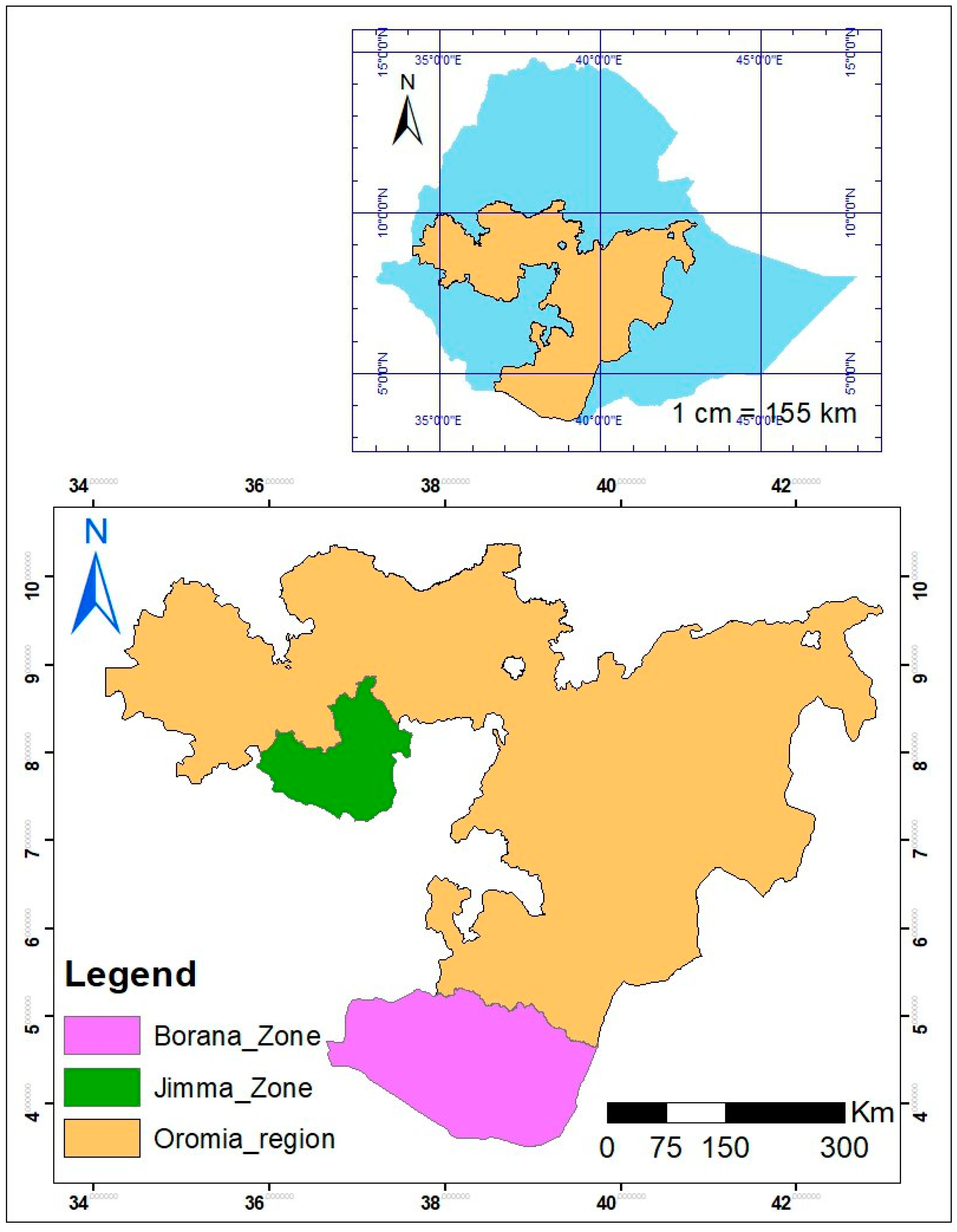
The study area includes the Jimma and Borena zones within the Oromia region of Ethiopia. The Jimma zone, with elevations ranging from 1000 to 3000 m, features diverse topography and a network of perennial and seasonal rivers. Groundwater is mainly extracted from shallow wells and springs. The Borena zone, characterized by its southern-sloping topography, lacks perennial rivers but has significant groundwater discharge through small springs and boreholes, especially along fault lines [46,47]. Figure 1 depicts the location of the Jimma and Borena zones within the Oromia Region of Ethiopia.

Figure 1.
The location of the study area in the Oromia region, Ethiopia, 2023.
2.2. Data Source and Analysis
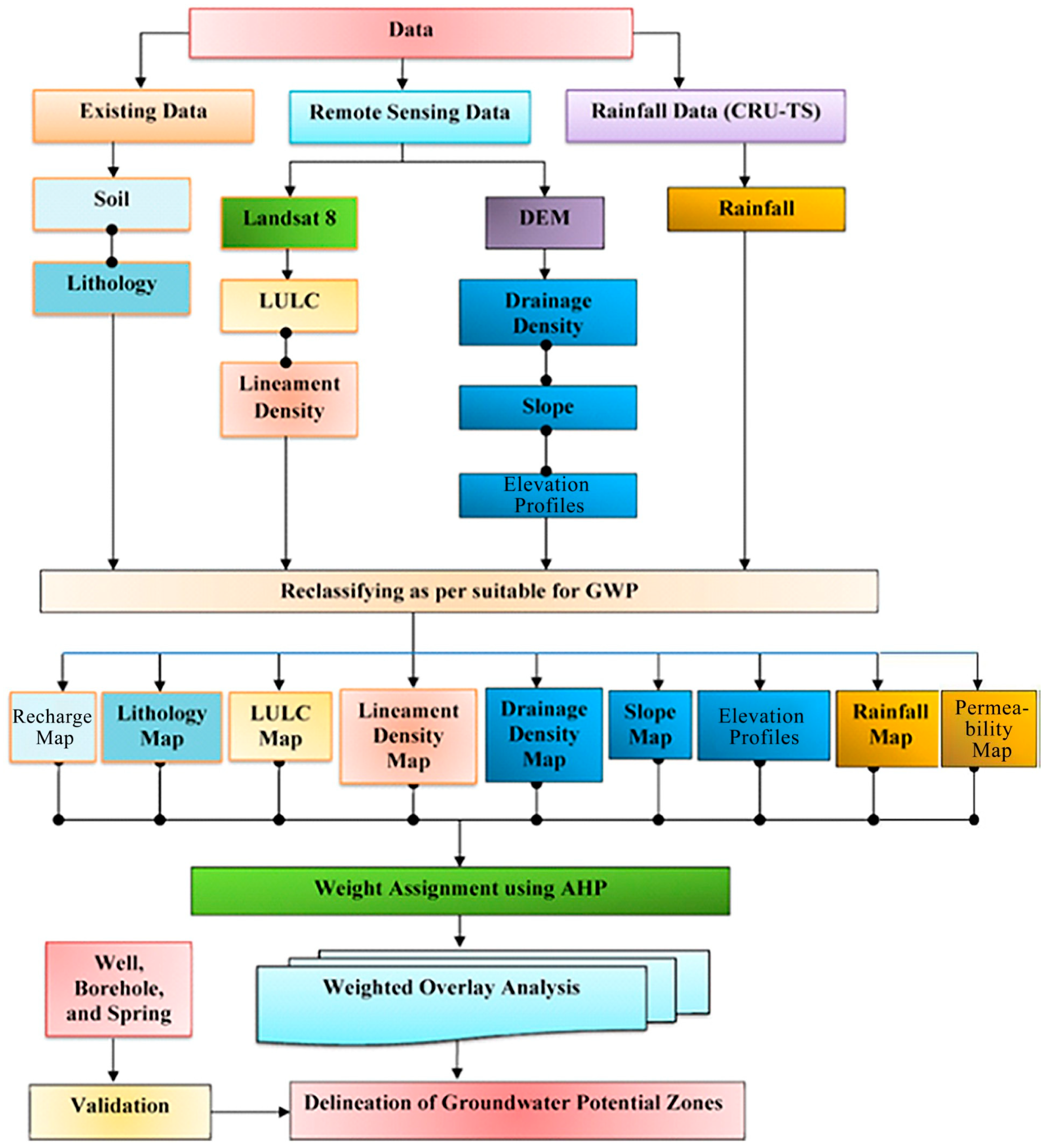
This study utilized a blend of primary and secondary datasets to evaluate groundwater suitability in the Jimma and Borena zones. The datasets incorporated Landsat 8 imagery, Shuttle Radar Topography Mission (SRTM) data, and rainfall data from CRU TS v. 4.04. These datasets were integrated into a Geographic Information System (GIS) to generate thematic layers, including slope, drainage density, land use/land cover (LULC), and lithology. The Analytical Hierarchy Process (AHP) was used to assign weights to each factor, which were then combined using a weighted overlay analysis to map groundwater potential zones [48].
The data source for this study included geological data from the Geological Survey of Ethiopia (GSE), topographic data from the US Geological Survey (USGS), rainfall data from the CRU TS v. 4.06 website, and soil data from the Ministry of Water, Irrigation, and Energy [48,49]. The AHP was applied to assign weights to factors influencing groundwater suitability, such as lithology, slope, recharge, and lineament density. The process involved comparing factors using Saaty’s 1–9 scale, calculating the consistency ratio (CR), validating the pairwise comparisons and assigning weights with expert opinions, reclassifying the factors in suitability categories, and integrating the AHP weights with GIS and remote sensing data using weighted overlay analysis in ArcGIS pro 3.4.3. A sensitivity analysis was conducted to evaluate the impact of weight variations on the final maps.
2.3. Criteria Thematic Layer Preparation
Several key parameters influencing groundwater availability were selected and analyzed, including drainage density, slope, elevation, recharge, LULC, lineament density, lithology, and permeability. Each parameter was processed and prepared as a thematic layer to facilitate groundwater suitability mapping. The recharge parameter was derived from a combination of precipitation data and infiltration coefficients. Precipitation data were sourced from the Climate Hazard Group InfraRed Precipitation with Stations (CHIRPS) dataset, covering 1990 to 2022 and providing high-resolution rainfall estimates [50]. Infiltration coefficients were obtained from the Abbay River Basin Integrated Development Master Plan Project, which assigned values to various lithological units. The methodology involved extracting the infiltration coefficient from a hydrogeological map and applying it to different geological domains. The final recharge was calculated as the product of precipitation data and the infiltration coefficient, expressed in mm/year. Permeability was estimated using hydrogeological maps from the British Geological Survey (BGS) in Ethiopia and expert judgment. A final permeability map was created, with colors representing different permeability levels. The lithology map was prepared using geological data from the GSE, while the DEM data, sourced from the SRTM, were processed to generate slope maps, drainage density maps, and elevation profiles. Elevation data were sourced from the Shuttle Radar Topography Mission (SRTM) 30 m resolution DEM and processed to create slope maps and elevation profiles. The identified profiles include uniform (flat terrain), concave (low-lying areas for water accumulation and potential groundwater recharge), and convex (higher elevations with rapid runoff). Areas with slopes greater than 20 degrees were deemed unsuitable for groundwater development due to rapid runoff. A rainfall map was generated using the Inverse Distance Weighting (IDW) interpolation method, based on high-resolution gridded rainfall data from CRU TS v. 4.06. The LULC map was developed using Landsat 8 imagery and processed through supervised classification techniques in Erdas Imagine 2014. Lineament features were automatically generated using PCI Geomatica 2016 and converted into a lineament density map. Permeability scores were assigned based on aquifer classes and integrated into the suitability analysis.
LULC classification was performed using the ESA WorldCover 2022 dataset (10 m resolution), derived from Sentinel-1 and Sentinel-2 (dry season) images as details in Table 1.

Table 1.
Land Use/Land Cover (LULC) description used in this study, in the Oromia region, Ethiopia, 2023.
2.4. Weight Assignment and Reclassification
The AHP was employed to assign weights to the various factors influencing groundwater suitability. Pairwise comparisons were conducted using Saaty’s 1–9 scale, and the consistency of the pairwise comparisons was evaluated using the CR. Expert opinions were solicited to validate the pairwise comparisons and ensure that the weights accurately reflected the hydrogeological characteristics of the study area. Each factor was reclassified into suitability categories based on predefined criteria. The AHP weights were integrated with GIS and remote sensing data using weighted overlay analysis in ArcGIS to produce the final groundwater suitability maps.
The Analytical Hierarchy Process (AHP) was used to assign weights to thematic layers, with values varying for the Borena and Jimma zones as details in Table 2.
Table 2.
The Analytical Hierarchy Process (AHP) assigned weight for each category, in the Oromia region, Ethiopia, 2023.
A sensitivity analysis was conducted to assess the impact of weight variations on the final suitability maps, confirming the robustness of the results. The Analytical Hierarchy Process (AHP) step-by-step process includes pairwise comparisons, consistency ratio calculations, and weight assignments, as well as how these weights are applied in WOA to generate groundwater suitability maps and its integration with Weighted Overlay Analysis (WOA), details shown in Figure 2 below.
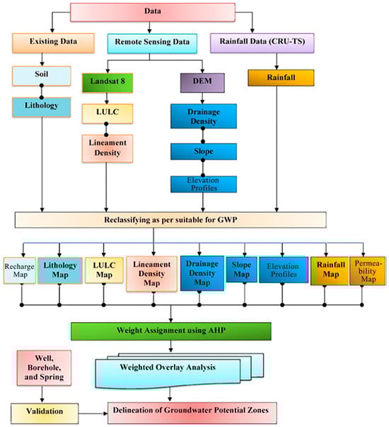
Figure 2.
The methodological framework for groundwater suitability mapping in the Oromia region.
The developed thematic layers were transformed into a raster format and classified according to their suitability for groundwater occurrence. Each sub-factor within the thematic layers was assigned ratings using a color code that ranges from blue (indicating high suitability) to orange and white (indicating unsuitable areas). Regions deemed completely unsuitable are represented in red.
2.5. Weighted Overlay Analysis (WOA)
The Weighted Overlay Analysis (WOA) is a robust method that empowers professionals to address complex spatial problems, especially those related to site suitability. It achieves this by integrating a range of factors such as rainfall drainage density, slope, elevation profiles, recharge, land use/land cover, lineament density, lithology, and permeability. In this study, we utilized the WOA tool to identify Groundwater Potential Zones (GWPZ). As previously discussed, the WOA tool operates on an evaluation scale from 1 to 5, which is used to assign scores to sub-parameters. We overlaid the reclassified raster maps of the selected parameters within the WOA tool. Each input raster in the analysis was then scored based on this evaluation scale. The final step in the process involves multiplying the weighted values of each raster layer by the score of each cell within the input rasters. This process is represented by the following equation: GWPZ = Σni = 1 WcXi, where GWPZ is the groundwater potential, Wc is the normalized weight of every thematic layer, and Xi is the rank of sub-factors.
3. Results
3.1. Groundwater Suitability Mapping
The groundwater potential map, produced at a scale of 1:100,000 using the weighted overlay analysis, identifies zones of high, medium, and low suitability for groundwater extraction. In the Jimma zone, flat terrains with permeable soils showed the highest potential, while steep regions were deemed unsuitable. In the Borena zone, volcanic aquifers, particularly the Bulal basalt formation, were identified as highly suitable for groundwater extraction. Validation using borehole data (437 points in Borena and 305 in Jimma) confirmed the model’s accuracy, especially in Borena, where groundwater potential aligned well with known geological structures. However, inaccuracies in lineament mapping in mountainous areas highlight the need for further geophysical surveys to refine the suitability maps. These findings are consistent with other studies in Ethiopia, emphasizing the importance of subsurface investigations for accurate groundwater assessment.
3.1.1. Jimma Zone Results
The groundwater suitability map for the Jimma zone (Figure 3) reveals that 4.6% of the area is highly suitable for groundwater development, primarily in flat terrains with high infiltration rates and permeable soils. A total of 24% of the zone is moderately suitable, while the majority (70%) is categorized as low suitability due to steep terrain, poor recharge, and low permeability. Low-lying areas with alluvial deposits and volcanic aquifers show greater groundwater potential. However, steep slopes and inaccurately mapped lineaments in mountainous regions were deemed unsuitable, underscoring the need for detailed geophysical surveys to improve data accuracy. Topography plays a critical role, with high recharge rates aligning with flatter regions. Despite these findings, the suitability map should be used cautiously, supplemented by conceptual models and subsurface investigations to better assess potential aquifer zones.
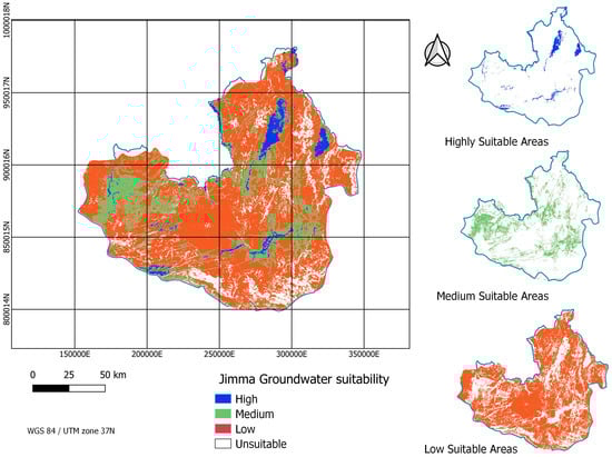
Figure 3.
The Jimma zone groundwater suitability.
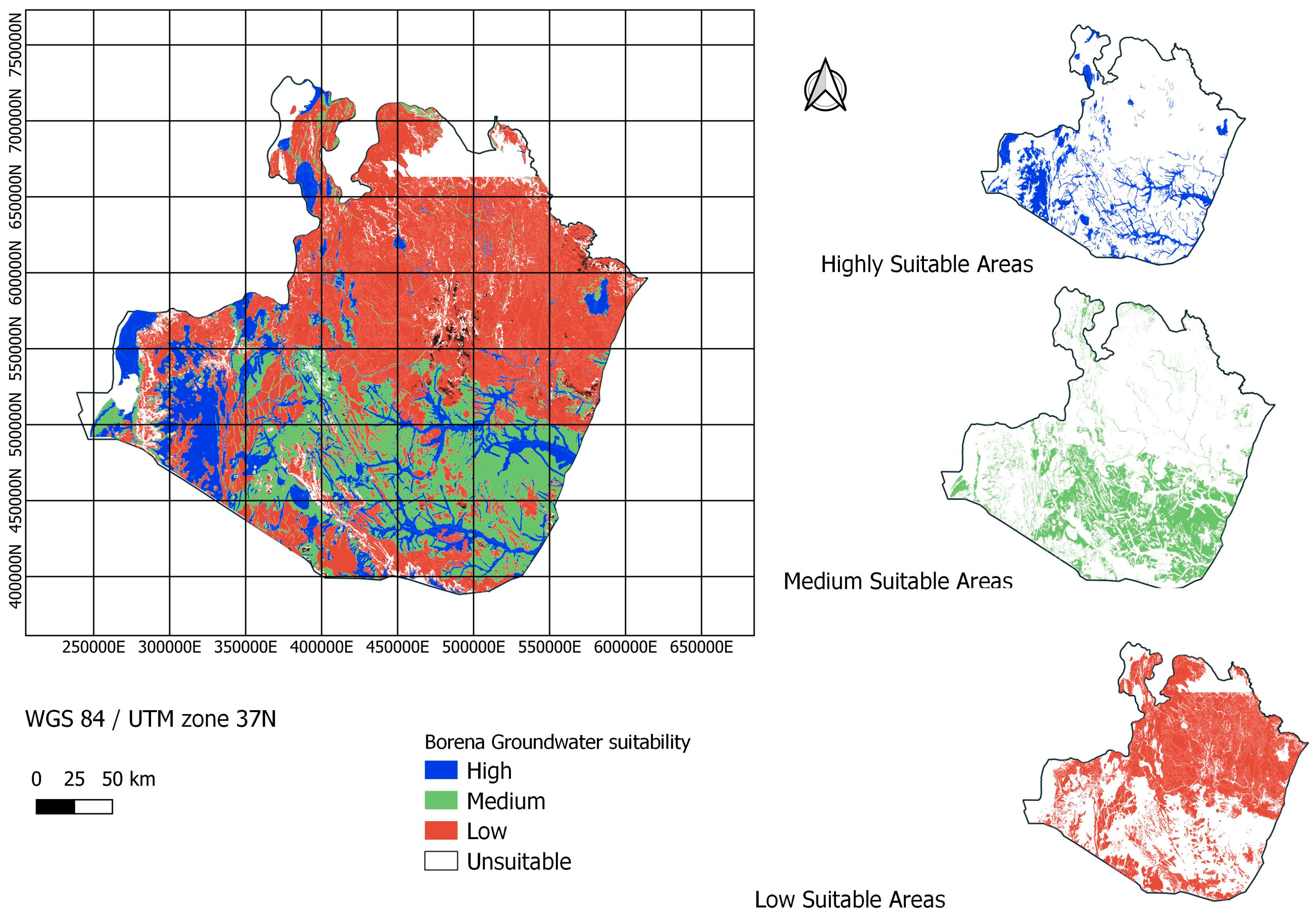
3.1.2. Borena Zone Results
In the Borena zone (Figure 4), 6.2% of the area is classified as highly suitable for groundwater, mainly in the southwestern volcanic region. A total of 42.6% falls into the medium suitability category, influenced by fractured basement rocks and alluvial deposits, while 51.1% is mapped as low suitability, particularly in the northern parts, due to crystalline basement rocks and unfavorable topographic conditions. The Bulal basalt aquifer in the southwest is a key groundwater resource, with an aquifer thickness ranging from 56 to 168 m. Other high-suitability areas include shallow alluvial deposits and weathered basement rocks. While volcanic regions offer clear groundwater prospects, areas with basement terrain and flat landscapes require further investigation to account for structural features, alluvial deposit thickness, and localized groundwater potential influenced by weathered basement rocks.
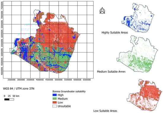
Figure 4.
The Borena zone groundwater suitability mapping.
3.1.3. Groundwater Suitability Map Validation
The groundwater suitability maps were validated using 437 borehole data points in Borena and 305 points in Jimma. The validation process employed robust statistical metrics, including the following: kappa coefficient (0.85), indicating a high level of agreement between predicted and observed suitability zones; ROC curve (AUC = 0.92), demonstrating strong predictive performance of the model; and RMSE (0.12), reflecting low error rates in the suitability predictions.
The error maps revealed that most discrepancies occurred in areas with complex topography or limited data availability, highlighting the challenges of mapping in such regions. Cross-validation techniques, such as k-fold cross-validation, yielded an average accuracy of 89%, further confirming the reliability of the maps. Field verification by a ground truthing team, which collected data on water quality and well yield, provided additional confirmation of the maps’ accuracy. Independent validation using government databases further strengthened the credibility of the results. The independent validation process for the groundwater suitability maps utilized diverse data sources, such as geospatial, water quality, and historical data, along with validation methods like field verification and model comparison to assess their effectiveness.
Despite the high accuracy, potential sources of error were identified, including inaccuracies in borehole data, such as incomplete or outdated records; limitations of remote sensing data, particularly in areas with complex terrain or dense vegetation; and subjectivity in weight assignments during the Analytical Hierarchy Process (AHP).
To address these limitations, this study recommends (1) conducting detailed geophysical surveys to improve subsurface data accuracy, especially in mountainous or data-scarce regions; using higher-resolution remote sensing data to enhance the precision of lineament detection and other spatial analyses; and involving a larger panel of experts to reduce subjectivity in the AHP. The methodology reported here performed well in both the Jimma and Borena zones, with slightly higher accuracy in Jimma due to its more favorable topographic conditions. These findings underscore the importance of integrating multiple validation techniques and addressing data limitations to improve the reliability of groundwater suitability mapping.
4. Discussion
The groundwater suitability score was computed by adding the weighted factors and visualized using a rainbow color scheme, with red indicating low suitability and blue indicating high suitability. The suitability maps, scaled at 1:100,000, identified high, medium, and low groundwater suitability zones in Jimma and Borena. These results are consistent with studies conducted in semi-arid regions, underscoring the efficacy of GIS and remote sensing techniques for groundwater exploration [22,28,35,51,52].
In Jimma, 4.6% of the area is highly suitable, 24% is moderately suitable, and 70% has low suitability. Borena shows 6.2% as highly suitable, 42.6% as moderately suitable, and 51.1% with low suitability. These findings align with those from other semi-arid regions [11,14,53].
Socio-economic factors play a crucial role in groundwater suitability and management in the Jimma and Borena zones. Increasing population and expanding agricultural practices, especially irrigation, significantly contribute to groundwater extraction, risking aquifer depletion in high-demand areas. Integrated water resource plans that consider both natural and socio-economic factors promote equitable access, and engaged local communities are vital for mitigating water scarcity and protecting livelihoods, particularly in rural areas dependent on agriculture and, additionally, districts primarily dependent on irrigations [5,54].
Topography emerged as a significant factor, with flatter terrains in both zones facilitating higher infiltration and recharge rates. This aligns with previous studies that highlight the positive correlation between low-gradient terrain and enhanced groundwater recharge [26,30,55,56]. Conversely, steep slopes promote surface runoff, reducing recharge and groundwater availability. These areas were categorized as low-suitability zones, reinforcing the established understanding that terrain steepness negatively impacts groundwater accumulation [1,21,31,40,57,58].
Lithological analysis spotlighted volcanic aquifers, such as the Bulal basalt formation in Borena, as key groundwater reservoirs due to their high fracture permeability and significant recharge capacity. In contrast, crystalline basement rocks exhibited low groundwater potential, aligning with findings from other geological studies [2,6,10,18,32].
Alluvial deposits in low-lying areas of both zones further enhanced groundwater potential, serving as shallow aquifers with significant storage capacities [4,5,37,59,60]. However, challenges, such as inaccuracies in lineament detection, particularly in mountainous areas, underscore the need for complementary geophysical surveys to improve subsurface mapping accuracy [7,17,23,61]. The subjectivity in weight assignments in the AHP also highlights the need for more objective methodologies [10,17,34,54].
In both Jimma and Borena, alluvial deposits, particularly in low-lying regions, significantly contribute to groundwater potential by serving as shallow aquifers. These areas benefit from surface water recharge from nearby rivers and streams, making them highly suitable for groundwater extraction. The presence of permeable alluvial soils in these regions enhances groundwater storage capacity [4,5,15,37,59,60,62,63,64].
The findings from this study have important implications for regional water resource management, particularly in the context of climate change and increasing water demand in semi-arid regions like Jimma and Borena. Incorporating climate change projections into future groundwater potential assessments would provide valuable insights into how shifting weather patterns may impact groundwater availability in the region [1,14,30,31,56,57,65,66]. Future studies should incorporate climate projections to enhance the reliability of groundwater potential assessments and support sustainable management [1,14,31,57]. The results of this study demonstrate the effectiveness of GIS and RS techniques in groundwater exploration while emphasizing the need for further refinement to address existing limitations and ensure accurate, actionable outcomes. This study addresses a critical research gap in groundwater mapping for semi-arid regions of Ethiopia by integrating GIS, remote sensing, and the AHP to delineate groundwater potential zones in Jimma and Borena. Unlike previous research focused on highland areas, it assesses groundwater suitability in the water-scarce, climate-variable Borena region. Utilizing high-resolution data and validating findings with borehole data, this study presents a reliable methodology for groundwater mapping. The results highlight the influence of topography, lithology, and recharge on groundwater potential, offering valuable insights for sustainable water management. This research provides a localized and integrated approach to tackle water scarcity challenges in semi-arid Ethiopia.
This study acknowledges several limitations that may affect the results:
- (1)
- Subjectivity in the AHP: The Analytic Hierarchy Process (AHP) involves subjective pairwise comparisons and weight assignments, which could introduce bias. Future research could benefit from a larger panel of experts or more objective criteria.
- (2)
- Lineament detection accuracy: The accuracy of detecting lineaments in complex terrains may be limited by the resolution of the remote sensing data. Future studies could enhance accuracy by integrating geophysical surveys (e.g., seismic or electrical resistivity).
- (3)
- Data resolution: The resolution of some data sources, such as the SRTM DEM and the Landsat imagery, may have adversely influenced results, especially in areas with fine-scale variations. Higher-resolution data like LiDAR could improve suitability maps.
- (4)
- Detailed socio-economic factors: Future studies could integrate these data for a more holistic view of groundwater potential and sustainability.
- (5)
- Validation process limitations: The validation relied on borehole data, which may not be uniformly distributed or fully representative. Future studies should consider using a more diverse set of validation data, such as geophysical surveys or hydrological models, to enhance reliability.
5. Conclusions
This study successfully mapped groundwater potential zones in the Jimma and Borena zones of Ethiopia using GIS, remote sensing, and the AHP techniques. The results indicate that 4.6% of Jimma and 6.2% of Borena are highly suitable for groundwater extraction, emphasizing the critical role of topography, lithology, and recharge in determining groundwater suitability. The maps provide a cost-effective and efficient tool for groundwater exploration, validated by borehole data and field surveys, and offer practical solutions for sustainable water resource management. These findings are crucial for informed decision-making and addressing the region’s future water needs.
Policymakers should prioritize groundwater exploration in highly suitable zones and integrate suitability maps into regional water resource management plans. Sustainable extraction practices should be implemented, such as setting extraction limits and promoting water conservation, to prevent over-extraction and ensure long-term water availability. Water resource managers should develop climate-resilient water management strategies, such as managed aquifer recharge and drought preparedness plans, to address shifts in recharge patterns due to climate change. Local capacity in GIS and remote sensing should be developed for regular groundwater monitoring and mapping. Policymakers should engage local communities in groundwater management initiatives to promote awareness and sustainable usage practices. At a minimum, public awareness campaigns should be implemented to foster a culture of water conservation and sustainable water use.
Author Contributions
G.M.A. and F.D.A. were involved in conceptualization, methodology, analysis, visualization, and writing—review and editing. G.M.A., G.A.K. and S.A. were involved in validation, comments, and editing of the manuscript. All authors have read and agreed to the published version of the manuscript.
Funding
This research was funded by Amref Health Africa in Ethiopia, grant number R232.
Data Availability Statement
The data presented in this study are available on request from the corresponding author.
Acknowledgments
We acknowledge Amref Health Africa in Ethiopia for providing the funding for this study. This research is part of the REACH project. We are also grateful for the Acacia consultancy, Abebe Ketema, and Segni Tesgera for support in the process of data collection and analysis.
Conflicts of Interest
The authors declare no conflicts of interest. The funders had no role in the design of the study; in the collection, analyses, or interpretation of data; in the writing of the manuscript; or in the decision to publish the results.
References
- Roy, S.; Bose, A.; Mandal, G. Modeling and mapping geospatial distribution of groundwater potential zones in Darjeeling Himalayan region of India using analytical hierarchy process and GIS technique. Model. Earth Syst. Environ. 2022, 8, 1563–1584. [Google Scholar] [CrossRef]
- Mechal, A.; Wagner, T.; Birk, S. Recharge variability and sensitivity to climate: The example of Gidabo River Basin, Main Ethiopian Rift. J. Hydrol. Reg. Stud. 2015, 4, 644–660. [Google Scholar] [CrossRef]
- Gumula-Kawecka, A.; Jaworska-Szulc, B.; Jefimow, M. Climate change impact on groundwater resources in sandbar aquifers in southern Baltic coast. Sci. Rep. 2024, 14, 11828. [Google Scholar] [CrossRef]
- Buvaneshwari, S.; Riotte, J.; Sekhar, M.; Kumar, M.M.; Sharma, A.K.; Duprey, J.L.; Audry, S.; Giriraja, P.; Praveenkumarreddy, Y.; Moger, H.; et al. Groundwater resource vulnerability and spatial variability of nitrate contamination: Insights from high density tubewell monitoring in a hard rock aquifer. Sci. Total Environ. 2017, 579, 838–847. [Google Scholar] [CrossRef]
- El-Hokayem, L.; De Vita, P.; Usman, M.; Link, A.; Conrad, C. Mapping potentially groundwater-dependent vegetation in the Mediterranean biome using global geodata targeting site conditions and vegetation characteristics. Sci. Total Environ. 2023, 898, 166397. [Google Scholar] [CrossRef]
- Kawo, N.S.; Hordofa, A.T.; Karuppannan, S. Performance evaluation of GPM-IMERG early and late rainfall estimates over Lake Hawassa catchment, Rift Valley Basin, Ethiopia. Arab. J. Geosci. 2021, 14, 256. [Google Scholar] [CrossRef]
- Fentahun, A.; Mechal, A.; Karuppannan, S. Hydrochemistry and quality appraisal of groundwater in Birr River Catchment, Central Blue Nile River Basin, using multivariate techniques and water quality indices. Environ. Monit. Assess. 2023, 195, 655. [Google Scholar] [CrossRef]
- Alshehri, F.; Abd El-Hamid, H.T.; Mohamed, A. Mapping coastal groundwater potential zones using remote sensing based AHP model in Al Qunfudhah region along Red Sea, Saudi Arabia. Heliyon 2024, 10, e28186. [Google Scholar] [CrossRef] [PubMed]
- Diriba, D.; Karuppannan, S.; Takele, T.; Husein, M. Delineation of groundwater potential zonation using geoinformatics and AHP techniques with remote sensing data. Heliyon 2024, 10, e25532. [Google Scholar] [CrossRef]
- Li, X.; Li, G.; Zhang, Y. Identifying Major Factors Affecting Groundwater Change in the North China Plain with Grey Relational Analysis. Water 2014, 6, 1581–1600. [Google Scholar] [CrossRef]
- Shube, H.; Kebede, S.; Azagegn, T.; Nedaw, D.; Haji, M.; Karuppannan, S. Estimating Groundwater Flow Velocity in Shallow Volcanic Aquifers of the Ethiopian Highlands Using a Geospatial Technique. Sustainability 2023, 15, 14490. [Google Scholar] [CrossRef]
- Kawo, N.S.; Karuppannan, S. Groundwater quality assessment using water quality index and GIS technique in Modjo River Basin, central Ethiopia. J. Afr. Earth Sci. 2018, 147, 300–311. [Google Scholar] [CrossRef]
- Liu, Y.; Li, M.; Zhang, Y.; Wu, X.; Zhang, C. Analysis of the Hydrogeochemical Characteristics and Origins of Groundwater in the Changbai Mountain Region via Inverse Hydrogeochemical Modeling and Unsupervised Machine Learning. Water 2024, 16, 1853. [Google Scholar] [CrossRef]
- Tamesgen, Y.; Atlabachew, A.; Jothimani, M. Groundwater potential assessment in the Blue Nile River catchment, Ethiopia, using geospatial and multi-criteria decision-making techniques. Heliyon 2023, 9, e17616. [Google Scholar] [CrossRef]
- Fallatah, O.; Khattab, M.R. Evaluation of Groundwater Quality and Suitability for Irrigation Purposes and Human Consumption in Saudi Arabia. Water 2023, 15, 2352. [Google Scholar] [CrossRef]
- Ghosh, D.; Mandal, M.; Banerjee, M.; Karmakar, M. Impact of hydro-geological environment on availability of groundwater using analytical hierarchy process (AHP) and geospatial techniques: A study from the upper Kangsabati river basin. Groundw. Sustain. Dev. 2020, 11, 100419. [Google Scholar] [CrossRef]
- Ibrahim, A.; Wayayok, A.; Shafri, H.Z.M.; Toridi, N.M. Remote Sensing Technologies for Unlocking New Groundwater Insights: A Comprehensive Review. J. Hydrol. X 2024, 23, 100175. [Google Scholar] [CrossRef]
- Mulu, G.A.; Kerebih, M.S.; Hailu, D.A. Groundwater perspective zone mapping coupled with remote sensing, GIS, AHP, and MIF models: A case study of the Gorezen watershed, Ethiopia. Water Pract. Technol. 2024, 19, 2774–2798. [Google Scholar] [CrossRef]
- Abate, S.G.; Amare, G.Z.; Adal, A.M. Geospatial analysis for the identification and mapping of groundwater potential zones using RS and GIS at Eastern Gojjam, Ethiopia. Groundw. Sustain. Dev. 2022, 19, 100824. [Google Scholar] [CrossRef]
- Campbell, F.; Tricco, A.C.; Munn, Z.; Pollock, D.; Saran, A.; Sutton, A.; Sutton, A.; White, H.; Khalil, H. Mapping reviews, scoping reviews, and evidence and gap maps (EGMs): The same but different—The “Big Picture” review family. Syst. Rev. 2023, 12, 45. [Google Scholar] [CrossRef]
- Rehman, A.; Islam, F.; Tariq, A.; Islam, I.U.; J, D.B.; Bibi, T.; Ahmad, W.; Waseem, L.A.; Karuppannan, S.; Al-Ahmadi, S. Groundwater potential zone mapping using GIS and Remote Sensing based models for sustainable groundwater management. Geocarto Int. 2024, 39, 2306275. [Google Scholar] [CrossRef]
- Thakur, J.K.; Singh, S.K.; Ekanthalu, V.S. Integrating remote sensing, geographic information systems and global positioning system techniques with hydrological modeling. Appl. Water Sci. 2017, 7, 1595–1608. [Google Scholar] [CrossRef]
- Getahun, B. Groundwater Potential Zone Assessment Using Remote Sensing, Geographical Information System (GIS), and Analytical Hierarchy Process (AHP) Techniques in Fogera Woreda, South Gondar Zone, Ethiopia. Qeios 2023. [Google Scholar] [CrossRef]
- Bhadran, A.; Girishbai, D.; Jesiya, N.P.; Gopinath, G.; Krishnan, R.G.; Vijesh, V.K. A GIS based Fuzzy-AHP for delineating groundwater potential zones in tropical river basin, southern part of India. Geosyst. Geoenviron. 2022, 1, 100093. [Google Scholar] [CrossRef]
- Zghibi, A.; Mirchi, A.; Msaddek, M.H.; Merzougui, A.; Zouhri, L.; Taupin, J.-D.; Chenini, I.; Tarhouni, J. Using Analytical Hierarchy Process and Multi-Influencing Factors to Map Groundwater Recharge Zones in a Semi-Arid Mediterranean Coastal Aquifer. Water 2020, 12, 2525. [Google Scholar] [CrossRef]
- Shinde, S.P.; Barai, V.N.; Gavit, B.K.; Kadam, S.A.; Atre, A.A.; Pande, C.B.; Radwan, N.; Elkhrachy, I. Assessment of groundwater potential zone mapping for semi-arid environment areas using AHP and MIF techniques. Environ. Sci. Eur. 2024, 36, 87. [Google Scholar] [CrossRef]
- Melese, T.; Belay, T. Groundwater Potential Zone Mapping Using Analytical Hierarchy Process and GIS in Muga Watershed, Abay Basin, Ethiopia. Glob. Chall. 2022, 6, 2100068. [Google Scholar] [CrossRef]
- Tolche, A.D. Groundwater potential mapping using geospatial techniques: A case study of Dhungeta-Ramis sub-basin, Ethiopia. Geol. Ecol. Landsc. 2021, 5, 65–80. [Google Scholar] [CrossRef]
- Aklilu, T.; Sahilu, G.; Ambelu, A. Vulnerability Assessment and Protection Zone Delineation for Water Supply Schemes in the Upper Awash Subbasin, Ethiopia, Sub-Saharan Africa. Environ. Health Insights 2024, 18, 11786302241258349. [Google Scholar] [CrossRef]
- Sallwey, J.; Schlick, R.; Bonilla Valverde, J.P.; Junghanns, R.; Vásquez López, F.; Stefan, C. Suitability Mapping for Managed Aquifer Recharge: Development of Web-Tools. Water 2019, 11, 2254. [Google Scholar] [CrossRef]
- Pavelic, P.; Giordano, M.; Keraita, B.N.; Ramesh, V.; Rao, T. Groundwater Availability and Use in Sub-Saharan Africa: A Review of 15 Countries; International Water Management Institute (IWMI): Colombo, Sri Lanka, 2012. [Google Scholar] [CrossRef]
- Megahed, H.A. GIS-based assessment of groundwater quality and suitability for drinking and irrigation purposes in the outlet and central parts of Wadi El-Assiuti, Assiut Governorate, Egypt. Bull. Natl. Res. Cent. 2020, 44, 187. [Google Scholar] [CrossRef]
- Lee, S.; Hyun, Y.; Lee, S.; Lee, M.-J. Groundwater Potential Mapping Using Remote Sensing and GIS-Based Machine Learning Techniques. Remote Sens. 2020, 12, 1200. [Google Scholar] [CrossRef]
- Hani, H.M.; El Din, M.M.N.; Khalifa, A.; Elalfy, E. Development of suitability map for managed aquifer recharge: Case study, West Delta, Egypt. AQUA-Water Infrastruct. Ecosyst. Soc. 2023, 72, 868–884. [Google Scholar] [CrossRef]
- Lee, S.; Kaown, D.; Koh, E.H.; Ko, K.S.; Lee, K.K. Delineation of groundwater quality locations suitable for target end-use purposes through deep neural network models. J. Environ. Qual. 2021, 50, 416–428. [Google Scholar] [CrossRef] [PubMed]
- Liang, C.P.; Sun, C.C.; Suk, H.; Wang, S.W.; Chen, J.S. A Machine Learning Approach for Spatial Mapping of the Health Risk Associated with Arsenic-Contaminated Groundwater in Taiwan’s Lanyang Plain. Int. J. Environ. Res. Public Health 2021, 18, 11385. [Google Scholar] [CrossRef] [PubMed]
- Aigbokhan, O.J.; Essien, N.E.; Ofordu, C.S.; Falana, A.R.; Adedoyin, E.D. Analytical Hierarchical Process (AHP) Techniques and Geospatial Technologies for Groundwater Potential Zone Mapping. J. Sci. Res. Rep. 2022, 28, 30–49. [Google Scholar] [CrossRef]
- Simonovich, S.; Florczak, K.L. Re-Envisioning Evidence Gap Maps With Qualitative Research. Nurs. Sci. Q. 2018, 31, 325–329. [Google Scholar] [CrossRef] [PubMed]
- Correia, M.M.; Kanyerere, T.; Jovanovic, N.; Goldin, J. Investigating the knowledge gap in research on climate and land use change impacts on water resources, with a focus on groundwater resources in South Africa: A bibliometric analysis. Water SA 2023, 49, 3. [Google Scholar] [CrossRef]
- Nigussie, W.; Hailu, B.T.; Azagegn, T. Mapping of groundwater potential zones using sentinel satellites (−1 SAR and -2A MSI) images and analytical hierarchy process in Ketar watershed, Main Ethiopian Rift. J. Afr. Earth Sci. 2019, 160, 103632. [Google Scholar] [CrossRef]
- Mathewos, Y.; Abate, B.; Dadi, M.; Mathewos, M. Evaluation of the groundwater prospective zone by coupling hydro-meteorological and geospatial evidence in Wabe River Catchment Omo Gibe River Basin, Ethiopia. Water Cycle 2024, 5, 37–58. [Google Scholar] [CrossRef]
- Soliman, K.M.A.; Amin, D.; Bekhit, H.M.; Hafiz, M.G.E.-R. Estimating natural groundwater recharge taking into consideration temporal and spatial variability for arid unconfined aquifer. Water Sci. 2024, 38, 359–377. [Google Scholar] [CrossRef]
- Abduljaleel, Y.; Amiri, M.; Amen, E.M.; Salem, A.; Ali, Z.F.; Awd, A.; Lóczy, D.; Ghzal, M. Enhancing groundwater vulnerability assessment for improved environmental management: Addressing a critical environmental concern. Environ. Sci. Pollut. Res. 2024, 31, 19185–19205. [Google Scholar] [CrossRef] [PubMed]
- Subbarayan, S.; Thiyagarajan, S.; Karuppannan, S.; Panneerselvam, B. Enhancing groundwater vulnerability assessment: Comparative study of three machine learning models and five classification schemes for Cuddalore district. Environ. Res. 2024, 242, 117769. [Google Scholar] [CrossRef] [PubMed]
- Etana, D.; Snelder, D.J.R.M.; van Wesenbeeck, C.F.A.; de Cock Buning, T. Trends of Climate Change and Variability in Three Agro-Ecological Settings in Central Ethiopia: Contrasts of Meteorological Data and Farmers’ Perceptions. Climate 2020, 8, 121. [Google Scholar] [CrossRef]
- Taye, G.; Kaba, M.; Woyessa, A.; Deressa, W.; Simane, B.; Kumie, A.; Berhane, G. Modeling effect of climate variability on malaria in Ethiopia. Ethiop. J. Health Dev. 2015, 29, 137–196. [Google Scholar]
- USGS. Earth Explorer. 2024. Available online: https://earthexplorer.usgs.gov/ (accessed on 28 February 2025).
- University of East Anglia, Climatic Research Unit; Harris, I.C.; Jones, P.D.; Osborn, T. CRU TS4.04: Climatic Research Unit (CRU) Time-Series (TS) Version 4.04 of High-Resolution Gridded Data of Month-by-Month Variation in Climate (Jan. 1901–Dec. 2019). Centre for Environmental Data Analysis, 2020. Available online: https://catalogue.ceda.ac.uk/uuid/89e1e34ec3554dc98594a5732622bce9 (accessed on 28 February 2025).
- Fienen, M.N.; Arshad, M. The International Scale of the Groundwater Issue. In Integrated Groundwater Management: Concepts, Approaches and Challenges; Jakeman, A.J., Barreteau, O., Hunt, R.J., Rinaudo, J.-D., Ross, A., Eds.; Springer International Publishing: Cham, Switzerland, 2016; pp. 21–48. [Google Scholar] [CrossRef]
- Hasan, M.F.; Smith, R.; Vajedian, S.; Pommerenke, R.; Majumdar, S. Global land subsidence mapping reveals widespread loss of aquifer storage capacity. Nat. Commun. 2023, 14, 6180. [Google Scholar] [CrossRef] [PubMed]
- Sutradhar, S.; Mondal, P. Groundwater suitability assessment based on water quality index and hydrochemical characterization of Suri Sadar Sub-division, West Bengal. Ecol. Inform. 2021, 64, 101335. [Google Scholar] [CrossRef]
- Chidambaram, S.; PMV, V.; Venkatramanan, S.; Nepolian, M.; Pradeep, K.; Panda, B.; Thivya, C.; Thilagavathi, R. Groundwater quality assessment for irrigation by adopting new suitability plot and spatial analysis based on fuzzy logic technique. Environ. Res. 2022, 204, 111729. [Google Scholar] [CrossRef]
- Russo, T.A.; Fisher, A.T.; Lockwood, B.S. Assessment of Managed Aquifer Recharge Site Suitability Using a GIS and Modeling. Ground Water 2015, 53, 389–400. [Google Scholar] [CrossRef]
- Rahman, M.A.; Rusteberg, B.; Gogu, R.C.; Lobo Ferreira, J.P.; Sauter, M. A new spatial multi-criteria decision support tool for site selection for implementation of managed aquifer recharge. J. Environ. Manag. 2012, 99, 61–75. [Google Scholar] [CrossRef]
- Narany, T.S.; Ramli, M.F.; Fakharian, K.; Aris, A.Z. A GIS-index integration approach to groundwater suitability zoning for irrigation purposes. Arab. J. Geosci. 2016, 9, 502. [Google Scholar] [CrossRef]
- Ali, S.; Verma, S.; Agarwal, M.B.; Islam, R.; Mehrotra, M.; Deolia, R.K.; Kumar, J.; Singh, S.; Mohammadi, A.A.; Raj, D.; et al. Groundwater quality assessment using water quality index and principal component analysis in the Achnera block, Agra district, Uttar Pradesh, Northern India. Sci. Rep. 2024, 14, 5381. [Google Scholar] [CrossRef]
- Dars, R.; Qureshi, A.L.; Jamali, M.A.; Memon, H.A.S.; Kori, S.M.; Oad, S. Subsurface groundwater aquifer mapping and quality characterization in Matiari district, Sindh, Pakistan. Environ. Monit. Assess. 2022, 195, 22. [Google Scholar] [CrossRef] [PubMed]
- Karakus, C.B. Groundwater potential assessment based on GIS-based Best-Worst Method (BWM) and Step-Wise Weight Assessment Ratio Analysis (SWARA) Method. Environ. Sci. Pollut. Res. 2023, 30, 31851–31880. [Google Scholar] [CrossRef]
- Hagos, Y.G.; Andualem, T.G. Geospatial and multi-criteria decision approach of groundwater potential zone identification in Cuma sub-basin, Southern Ethiopia. Heliyon 2021, 7, e07963. [Google Scholar] [CrossRef]
- Ahmed, A.; El Ammawy, M.; Hewaidy, A.G.; Moussa, B.; Abdel Hafz, N.; El Abd, E.S. Mapping of lineaments for groundwater assessment in the Desert Fringes East El-Minia, Eastern Desert, Egypt. Environ. Monit. Assess. 2019, 191, 556. [Google Scholar] [CrossRef] [PubMed]
- Al-Mayahi, H.M.; Al-Abadi, A.M.; Fryar, A.E. Probability mapping of groundwater contamination by hydrocarbon from the deep oil reservoirs using GIS-based machine-learning algorithms: A case study of the Dammam aquifer (middle of Iraq). Environ. Sci. Pollut. Res. 2021, 28, 13736–13751. [Google Scholar] [CrossRef]
- Dhaloiya, A.; Singh, J.P.; Malik, A.; Singh, M.C.; Kumar, A. Spatio-temporal trends in long-term seasonal groundwater level of South-western Punjab using non-parametric statistical tests. Environ. Sci. Pollut. Res. 2024, 31, 37610–37651. [Google Scholar] [CrossRef] [PubMed]
- Raheja, H.; Goel, A.; Pal, M. An evaluation of groundwater quality and its suitability for drinking and irrigation uses under the GIS framework. Water Pract. Technol. 2022, 17, 2259–2277. [Google Scholar] [CrossRef]
- Sangadi, P.; Kuppan, C.; Ravinathan, P. Effect of hydro-geochemical processes and saltwater intrusion on groundwater quality and irrigational suitability assessed by geo-statistical techniques in coastal region of eastern Andhra Pradesh, India. Mar. Pollut. Bull. 2022, 175, 113390. [Google Scholar] [CrossRef]
- Rahman, M.A.; Rusteberg, B.; Uddin, M.S.; Lutz, A.; Saada, M.A.; Sauter, M. An integrated study of spatial multicriteria analysis and mathematical modelling for managed aquifer recharge site suitability mapping and site ranking at Northern Gaza coastal aquifer. J. Environ. Manag. 2013, 124, 25–39. [Google Scholar] [CrossRef]
- Niyazi, B.A.M.; Rajmohan, N.; Masoud, M.H.Z.; Alqarawy, A.M. Groundwater quality appraisal and zone mapping for agriculture utilities in Wadi Fatima, Saudi Arabia using water quality indices, boron and trace metals. Environ. Sci. Pollut. Res. 2024, 31, 40995–41012. [Google Scholar] [CrossRef]

Disclaimer/Publisher’s Note: The statements, opinions and data contained in all publications are solely those of the individual author(s) and contributor(s) and not of MDPI and/or the editor(s). MDPI and/or the editor(s) disclaim responsibility for any injury to people or property resulting from any ideas, methods, instructions or products referred to in the content. |
© 2025 by the authors. Licensee MDPI, Basel, Switzerland. This article is an open access article distributed under the terms and conditions of the Creative Commons Attribution (CC BY) license (https://creativecommons.org/licenses/by/4.0/).