Article

Developing a Multi-Objective Optimization Scheduling Method for the Yangtze to Huaihe River Water Diversion Project Considering Lake Regulation and Storage

1
College of Civil and Hydraulic Engineering, Bengbu University, Bengbu 233030, China
2
College of Hydrology and Water Resources, Hohai University, Nanjing 210098, China
3
Anhui Provincial Group Limited for Yangtze-to-Huaihe Water Diversion, Hefei 230000, China
4
Anhui Survey & Design Institute of Water Resources & Hydropower Co., Ltd., Hefei 230000, China
*
Author to whom correspondence should be addressed.
Water 2025, 17(9), 1286; https://doi.org/10.3390/w17091286
Submission received: 12 March 2025 / Revised: 23 April 2025 / Accepted: 24 April 2025 / Published: 25 April 2025
(This article belongs to the Special Issue Optimization-Simulation Modeling of Sustainable Water Resource)

Abstract

:
Inter-basin water diversion projects have emerged as a critical solution to address water scarcity crises stemming from the uneven spatial distribution of water resources. The economic feasibility of these projects is significantly influenced by multiple factors, including water source composition, target beneficiaries, and the specific characteristics of diversion routes and distances. This research developed a novel multi-objective optimization framework utilizing a simulation-based optimization methodology designed to formulate efficient joint operational strategies that maximize water supply reliability while reducing operational expenditures. The practicality of this framework is validated through its implementation in the Yangtze to Huaihe River Water Diversion Project (YHWDP) in China. The results revealed that the proposed joint operation rules achieve substantial improvements in both water supply efficiency and cost-effectiveness. Specifically, the model demonstrated the capability to maintain a 95.5% water supply rate while reducing the water pumping volume to only 1.84 × 10⁹ m3. Furthermore, comparative analyses with conventional operation rules showed that the joint operation strategy effectively utilized the runoff regulation capacity of lakes while significantly mitigating water level fluctuations. During the water diversion period, the average variance of the time series of water volume in three lakes decreased by 54.5%, thereby contributing to the preservation of ecological stability for lake flora and fauna. The findings of this research not only provided practical insights for optimizing the operational performance of the YHWDP but also established a valuable framework for developing joint operation strategies in similar long-distance water diversion projects between basins.

1. Introduction

Water resources are vital for the sustenance of human society and ecosystems [1]. However, in many regions around the world, the scarcity of water resources fails to meet the increasingly growing local water demands [2,3]. The global freshwater crisis is intensifying due to compounding anthropogenic and environmental pressures. Key drivers, including demographic expansion, climatic shifts, ecological degradation, and accelerated urban development, are amplifying the inherent variability in water resource distribution across temporal and spatial dimensions, elevating water security concerns to a critical planetary-scale issue [4]. Countries around the world commonly adopt a method of transferring water resources through diversion systems, concentrating freshwater extraction and delivery to water-scarce regions, which can effectively alleviate local water resource shortages [5]. Scholars around the world have conducted extensive research on water diversion projects to address the challenges of global water scarcity [2,6,7]. The focus of these studies has been on optimizing water resource allocation, minimizing environmental impacts, and enhancing system efficiency.
China exhibits pronounced spatial and temporal heterogeneity in its freshwater resource distribution [8]. Southern regions maintain abundant water availability throughout the hydrological year, whereas northern areas experience systemic water scarcity compounded by seasonal variability. To address this hydrological disparity, China has implemented a series of inter-basin water transfer megaprojects, including the South to North Water Diversion Project, the Yangtze to Huaihe River Diversion Project, and the Hanjiang to Weihe River Water Diversion Project, among others [9,10,11,12]. These projects not only alleviate water scarcity in the northern regions but also provide strong support for local economic and social development.
Previous research has primarily focused on improving the solution methods for optimization scheduling models of water diversion projects, mainly targeting cascade reservoir systems [1,4,13,14,15]. However, studies on joint scheduling involving lake regulation, particularly the optimization gradient for the utilization of storage capacity, remain insufficient [16]. Moreover, previous studies have focused solely on optimizing water diversion volumes and water shortage rates, without considering the potential ecological crises that may arise as a result [17,18]. To enhance the utilization of lake storage capacity in large-scale inter-basin water transfer projects while minimizing ecological impacts, a multi-objective optimization model incorporating lake regulation functions has been developed. The model takes into account the storage capacity of the lake. When the upstream inflow exceeds the downstream water demand, the excess water can be stored in the lake to avoid wastage. Conversely, when the upstream inflow is insufficient to meet the downstream demand, the lake can release additional water to fulfill the downstream requirements. Compared to previous studies, this model not only achieves the maximum water supply while minimizing the water diversion volume but also significantly reduces the ecological and environmental impacts on lakes along the route during the water diversion process. As a result, the optimized solution demonstrates superior comprehensive benefits. Considering that ten-day water allocation is constrained by both the total monthly water allocation and daily water allocation, this paper selects the ten-day period as the time scale for the optimization schedule. Finally, a scientifically rational water scheduling plan was formulated and applied to the Anhui section of the Yangtze to Huaihe Water Diversion Project (A-YHWDP). Through a comparison with traditional scheduling schemes, the advantages of the newly established optimization scheduling system were demonstrated. The research findings provide a valuable scientific reference for the optimization scheduling of water diversion projects in other similar regions.

2. Study Area and Data
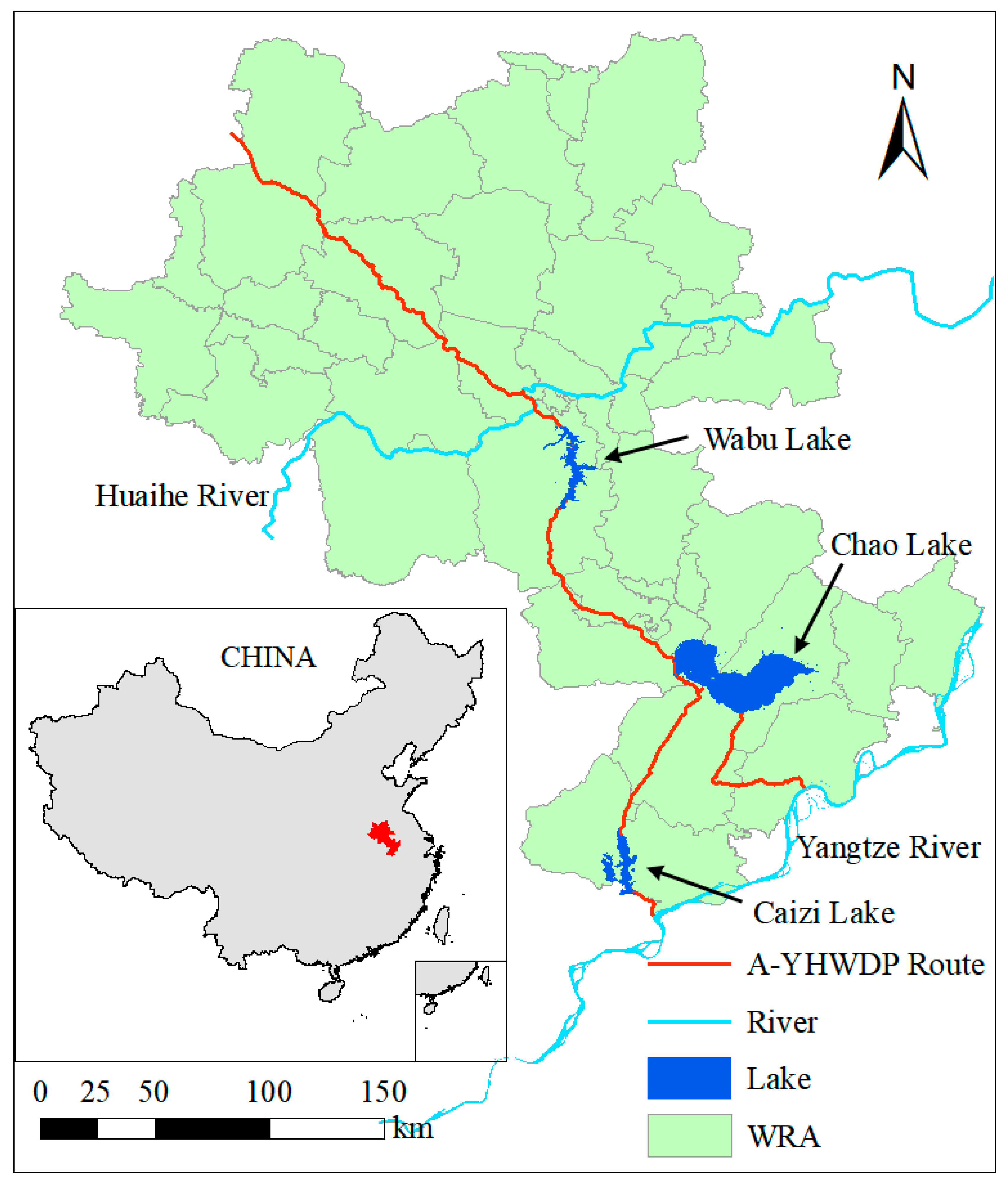
2.1. Study Area

The Yangtze to Huaihe River Water Diversion Project (Figure 1), which connects the Yangtze River and the Huaihe River, is a major cross-basin and cross-regional water resource allocation and comprehensive utilization project [19]. The water-receiving area spans two provinces, Anhui and Henan, specifically including 15 cities: Anqing, Tongling, Wuhu, Ma’anshan, Hefei, Lu’an, Chuzhou, Huainan, Bengbu, Huaibei, Suzhou, Fuyang, and Bozhou in Anhui Province, as well as Zhoukou and Shangqiu in Henan Province. The total area of the water-receiving region is 70,600 km2. The project consists of three parts: the Yangtze River–Chaohu Lake Water Diversion, the Yangtze River–Huaihe River Connection, and the Yangtze River Water Northward Conveyance [20]. It fulfills a diverse range of water requirements, including those for agriculture, industry, household use, navigation, and ecological conservation, across the entire diversion route [21].
In Figure 2, the topological relationships of the A-YHWDP are summarized as a schematic diagram based on geographical locations. To model the core elements of the system and the interlinkages among key rivers, lakes and pumping stations are treated as nodal points, major rivers as connecting lines, and water users are appropriately distributed between the nodes along the water diversion route.
In the Yangtze River Diversion to Chaohu Lake section, the Caizi Lake Zongyang Pumping Station and the Xi River Fenghuangjing Station serve as the diversion gates of the Yangtze River, acting as the starting points of the Caizi Lake Yangtze River Diversion Route and the Xi Zhao River Yangtze River Diversion Route, respectively. Specifically, the Zongyang Pumping Station diverts water from the Yangtze River into the Chang River, which flows into Caizi Lake. After crossing the watershed of the Chaohu Lake Basin, the water enters the Luo River, a tributary of Chaohu Lake. The Fenghuangjing Station diverts water from the Yangtze River along the main course of the Xi River, flowing westward to Quekou and then into the Zhao River. The water continues northward along the main course of the Zhao River, passing through the Zhao River Sluice and entering Chaohu Lake. The Lujiang Control Gate and the Baishan Control Gate can regulate the water diverted from Caizi Lake and Chaohu Lake to the Jianghuai Connection Section, respectively. In the Jianghuai Connection Section, the water diverted from the Caizi Lake Route and the Chaohu Lake Route converge at the Xiaohe Line. The water is then lifted in two stages by the Paikou Pumping Station and the Shushan Pumping Station before entering the Wabu Lake for storage. The Dongfei River Control Gate can regulate the flow of water from Wabu Lake to the Huai River. The diverted Yangtze River water flows through the main course of the Huai River into the Northbound Water Diversion Section to meet the agricultural and centralized water demands of Anhui, Shandong, and other regions.

2.2. Data

The joint optimal operating system of the A-YHWDP at this time adopts a monthly scale scheme. Anhui Provincial Group Limited for the Yangtze to Huaihe Water Diversion has provided relevant hydrological and socio-economic data (monthly observed inflow data for various lakes and water demand data for industrial and agricultural use along the route). The water level–storage capacity curves of Caizi Lake, Chaohu Lake, and Wabu Lake are shown in Figure 3, indicating a positive correlation between the water level and storage capacity. Table 1 presents the upper and lower limits of the water levels for each lake, which are used as constraint functions in the optimization system. Notably, for flood prevention purposes, the water levels of Chao Lake and Wabu Lake need to stay lower than usual from May to September each year. The initial water level data of the three lakes were obtained from the management departments of the Yangtze River and Huaihe River basins. According to the design report of the A-YHWDP, the water demand of cities along the route has been determined.

3. The Joint Optimal Operation Model of A-YHWDP

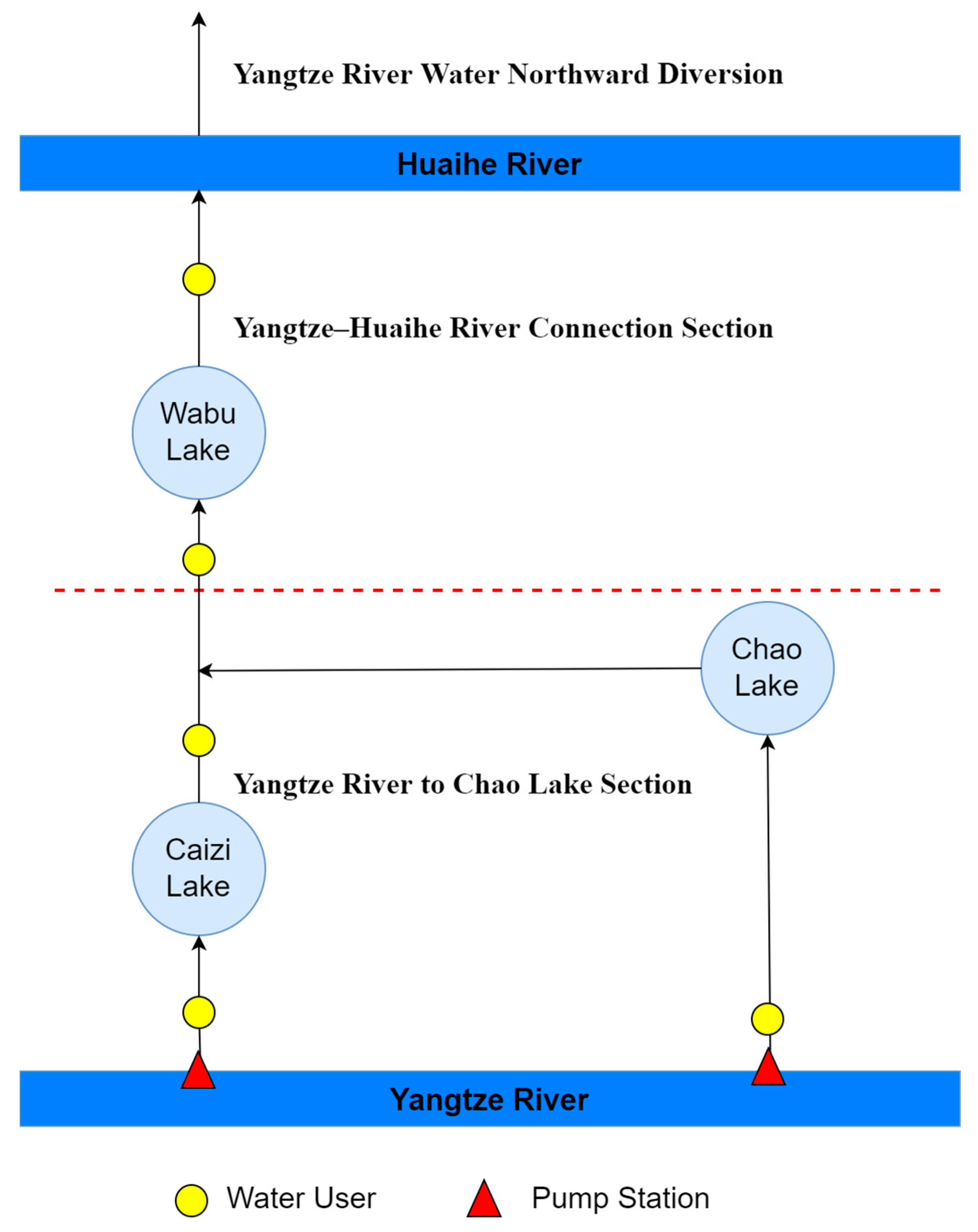
3.1. Design of Water Diversion Rules

The constructed multi-objective ten-day water quantity optimization scheduling model for pumping stations and lakes, which considers lake regulation and storage, primarily focuses on the energy consumption of water conveyance by pumping stations and the regulation capacity of lakes. The gates are treated in a flat inflow and outflow mode, without considering their regulatory effects on the water volume of rivers and channels. Therefore, the daily processes of the water diversion flow at the Zongyang Pumping Station, the water diversion flow at the Fenghuangjing Pumping Station, the outflow from Caizi Lake, the outflow from Chao Lake, and the outflow from Wabu Lake are treated as decision variables.

3.2. Objectives

(1)
Minimizing the total pumped water
The total pumping volume reflects the economic cost of the water conveyance project. The smaller the total pumping volume, the lower the cost of the project.
min F 1 = t = 1 T j = 1 J q j , t t
Here, T represents the entire operational duration, with t ranging from 1 to T; q j , t (m3/s) denotes the water pumped by the jth pumping station at time step t, where j spans from 1 to J, with J being the total number of pumping stations; and Δt signifies the duration of each time step.
(2)
Minimizing the water deficit
The water deficit serves as an indicator of the effectiveness of the operational strategy’s execution. This objective focuses on reducing the average shortfall in water supply by the conclusion of a specified operational timeframe, thereby enhancing user satisfaction and optimizing the strategy’s overall performance.
min F 2 = t = 1 T i = 1 n D i ,     t W i , t D i ,     t × 100 %
In this context, D i ,   t represents the water demand of the ith user at time step t, W i , t (m3) represents the water supply allocated to the ith user at time step t, and n ranges from 1 to N, with N being the total number of water demand areas.
(3)
Minimizing lake storage variance
The lake storage capacity evenness index represents the degree of stability of the lake storage capacity and can serve as an indicator of water ecologic environment evenness. The smaller the lake storage evenness index, the lesser the impact of the project on the lake water level and storage capacity.
min F 3 = t = 1 n S i , t i = 1 n S i , t n 2 n
In this framework, S i , t signifies the storage of the ith lake at time step t, with i varying from 1 to n (where n is the total count of lakes, which is set to 3 in this study), and t extends from 1 to T, where T represents the complete operational timeframe.

3.3. Constraints

Throughout the operational period of the water diversion initiative, it is essential to adhere to key physical constraints such as water balance, lake storage, sluice capacity, and pumping capacity limits. The specific description of these constraints is as follows:
(1)
Water balance constraint
The water diversion process must adhere to the water balance constraint to ensure proper system functioning.
V i , t + 1 = V i , t + Q i , t P R i , t
At time step t, the variables are defined as follows: V i , t denotes the storage capacity of the ith lake, Q i , t represents the inflow to the ith lake, and P R i , t reflects the outflow released from the ith lake.
(2)
Pumping capacity constraint
0 D I i , t D I m a x i , t
At time step t, the following parameters are defined: D I i , t represents the actual pumping volume to the ith lake, and D I m a x i , t signifies the maximum capacity for pumping water northward.
(3)
Sluice capacity constraint
0 P R i , t P R m a x i , t
Here, P R i , t represents the water released from the ith lake, while P R m a x i , t denotes the maximum discharge capacity of the sluice at time step t.
(4)
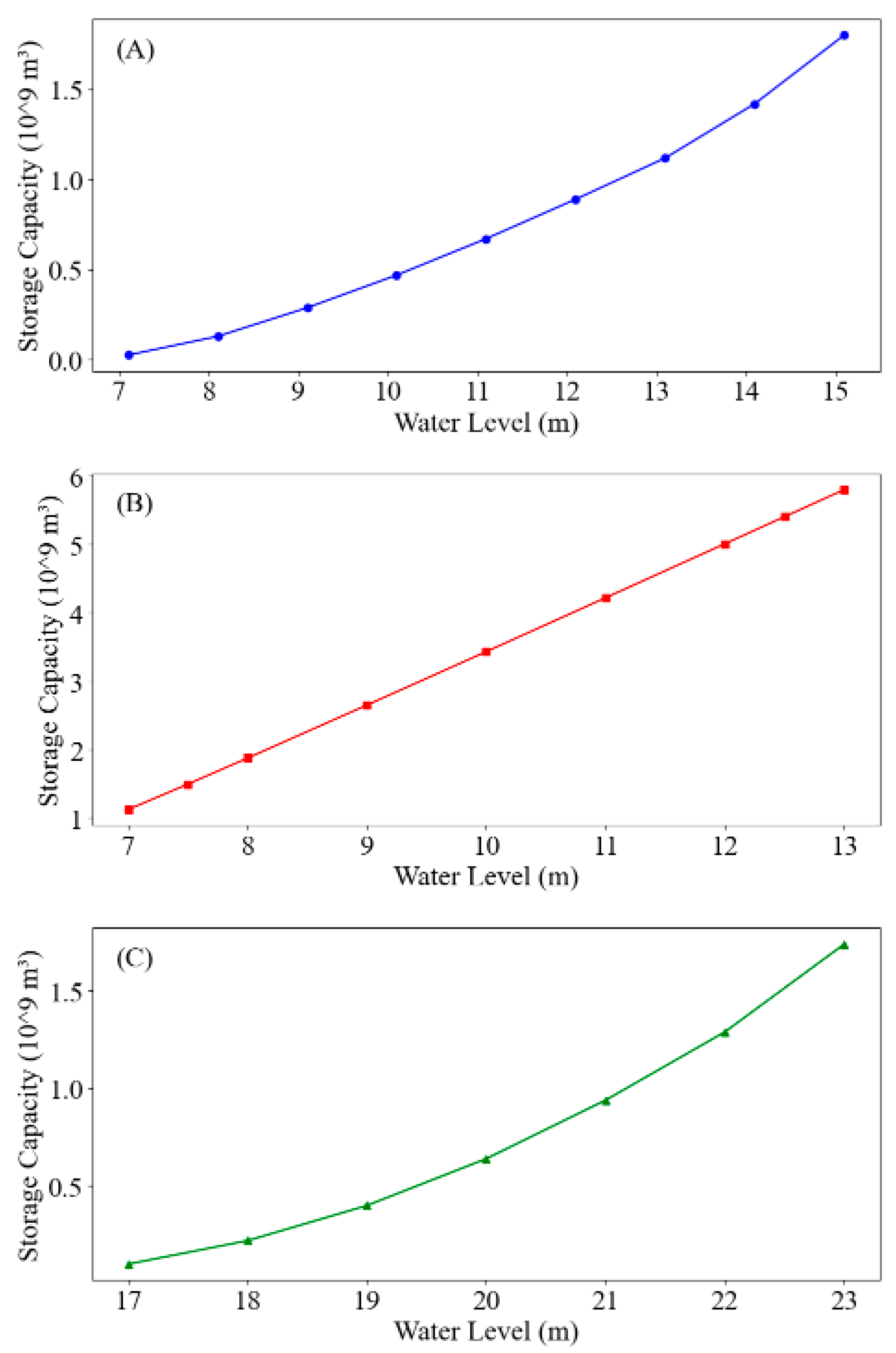
Lake storage constraint
V m i n i , t V i , t V m a x i , t
Here, V i , t represents the water storage volume of the ith lake at time step t, with V m i n i , t and V m a x i , t indicating the minimum and maximum storage capacities at that time step, respectively.
(5)
Minimum lake levels for water diversion
Z m i n i , t Z i , t Z m a x i , t
In this case, Z i , t refers to the water level of the ith lake at time step t, where Z m i n i , t and Z m a x i , t indicate the minimum and maximum permissible levels for the ith lake at that specific time step, respectively.

3.4. Model Solving and Solution Selection

Figure 4 delineates the optimization framework implemented for the A-YHWDP. To address the multi-objective optimization challenges under heterogeneous physical constraints, the NSGA-II (Non-dominated Sorting Genetic Algorithm II) was adopted as the computational engine. This evolutionary algorithm has gained prominence in hydraulic engineering applications due to its computational efficiency in Pareto front generation, and is particularly effective for resolving complex water allocation dilemmas. The mathematical formulation incorporates the actual pumping capacities of individual stations as decision parameters, with algorithmic hyperparameters specifically configured as population size = 200, maximum generations = 20,000, crossover probability = 0.9, and mutation probability = 0.1. The implementation of specific optimization algorithms is shown in the following steps:
(1)
The decision variables are defined as the monthly pumping volumes at individual pumping stations across a 12-month operational cycle, forming the annual decision space. Population initialization is conducted under engineering constraints, producing N-dimensional solution vectors through feasibility-preserving stochastic sampling.
(2)
Each solution candidate is evaluated against three concurrent objective functions—(i) the total pumping volume, (ii) average water deficit ratio, and (iii) reservoir storage evenness index. Non-dominated sorting categorizes solution hierarchies based on dominance relationships.
(3)
High-quality chromosomes are chosen from the non-dominated set to serve as parent individuals, and offspring are generated through crossover and mutation processes.
(4)
The parent and offspring chromosomes are merged, and then the population is refined using a non-dominated sorting approach.
(5)
The aforementioned four-step process continues to be iteratively executed until the predefined iteration count is achieved.
Figure 4. Optimization process of the A-YHWDP.
Water 17 01286 g004
By applying the NSGA-II algorithm [22,23,24], a collection of optimized operational strategies (those ranked in the top 200 based on Pareto dominance) was derived. As a result, this study incorporates multi-criteria decision-making methodologies to enhance and identify the most effective strategy. The research utilizes the TOPSIS-Entropy [25,26,27] framework to determine subjective weights and the entropy technique to derive objective weights. The final outcome is the selection of the most effective solution as the refined plan for the water transfer project.

4. Results

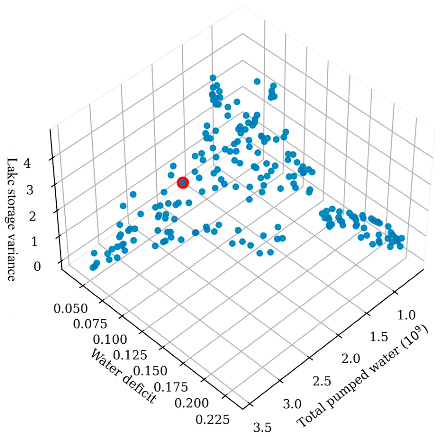
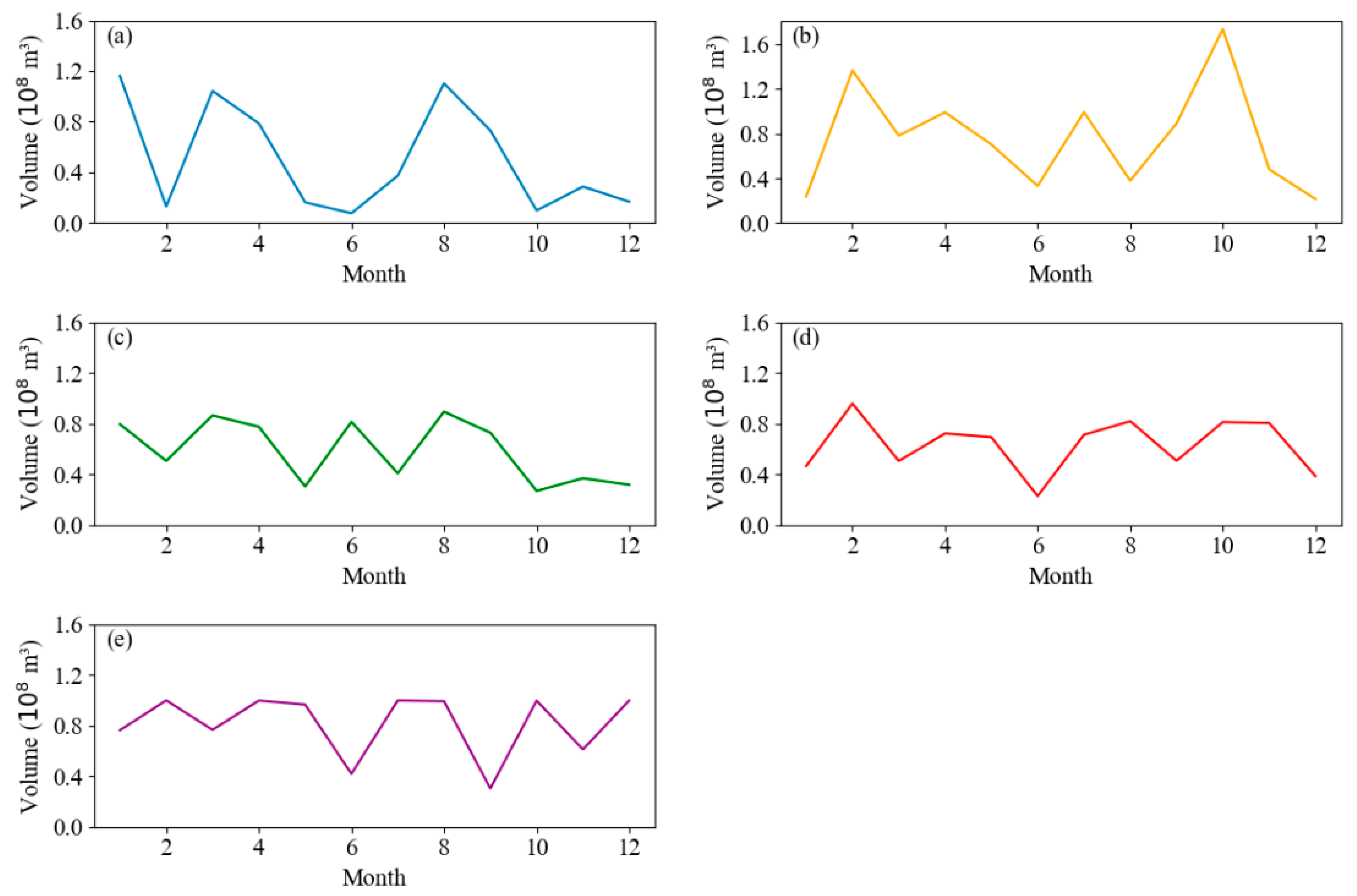
4.1. Pareto Solutions for the A-YHWDP

The principle of the joint optimization operation is to minimize the water shortage rate for each water user along the route while also minimizing the total water extraction and the variation in lake water volume. This approach ensures that the efficiency of the water transfer project is maximized while simultaneously maintaining stable water levels in the three lakes, thereby preventing any potential damage to the lakes’ plant and animal ecosystems caused by the project. Furthermore, the optimized operation system also takes into account the lakes’ inherent flood control functions, striving to maintain water levels at a lower demand threshold during the flood season. By harnessing the natural inflow of water into the lakes during this period, the system not only fulfills its water supply responsibilities but also enhances the overall utilization efficiency of water resources. It shows that the variance in lake water volume decreases with an increase in the water extraction volume.
Figure 5 presents the visualization of the Pareto front for the optimization strategy, clearly showing that the distribution of solutions across different dimensions is well-balanced. By analyzing the relative relationships among the optimization objectives, it is evident that the total water shortage rate and the total water extraction volume are negatively correlated. This indicates that the water shortage rate decreases as the water extraction volume increases. Similarly, the variance in the lake water volume during the operation period also exhibits a negative correlation with the total water extraction volume.
After conducting multi-criteria decision-making using the TOPSIS-Entropy weight method, the specific steps are as follows: First, the entropy weight method is used to assign weights to each objective, then TOPSIS is applied for comprehensive scoring, and the solution with the highest score is selected as the optimal one. The red marked point was identified as the optimal decision. The result of the optimized solution is a total pumped water volume of 1.84 × 10⁹ m3, a total water deficit of 4.46%, and a storage capacity variance of 1.06 × 10¹⁵, as detailed in Table 2.
Additionally, Figure 6 displays the sequence values of five decision variables over a one-year period—the pumping volumes at two pumping station and the outflow volumes from three lakes. Figure 6a represents the Zongyang Pumping Station, Figure 6b represents the Fenghuangjing Pumping Station, Figure 6c represents Caizi Lake, Figure 6d represents Chao Lake, and Figure 6e represents Wabu Lake. The outflow from Caizi Lake and Chao Lake is influenced by the two pumping stations, respectively, while the outflow from Wabu Lake is jointly affected by both Caizi Lake and Chao Lake.

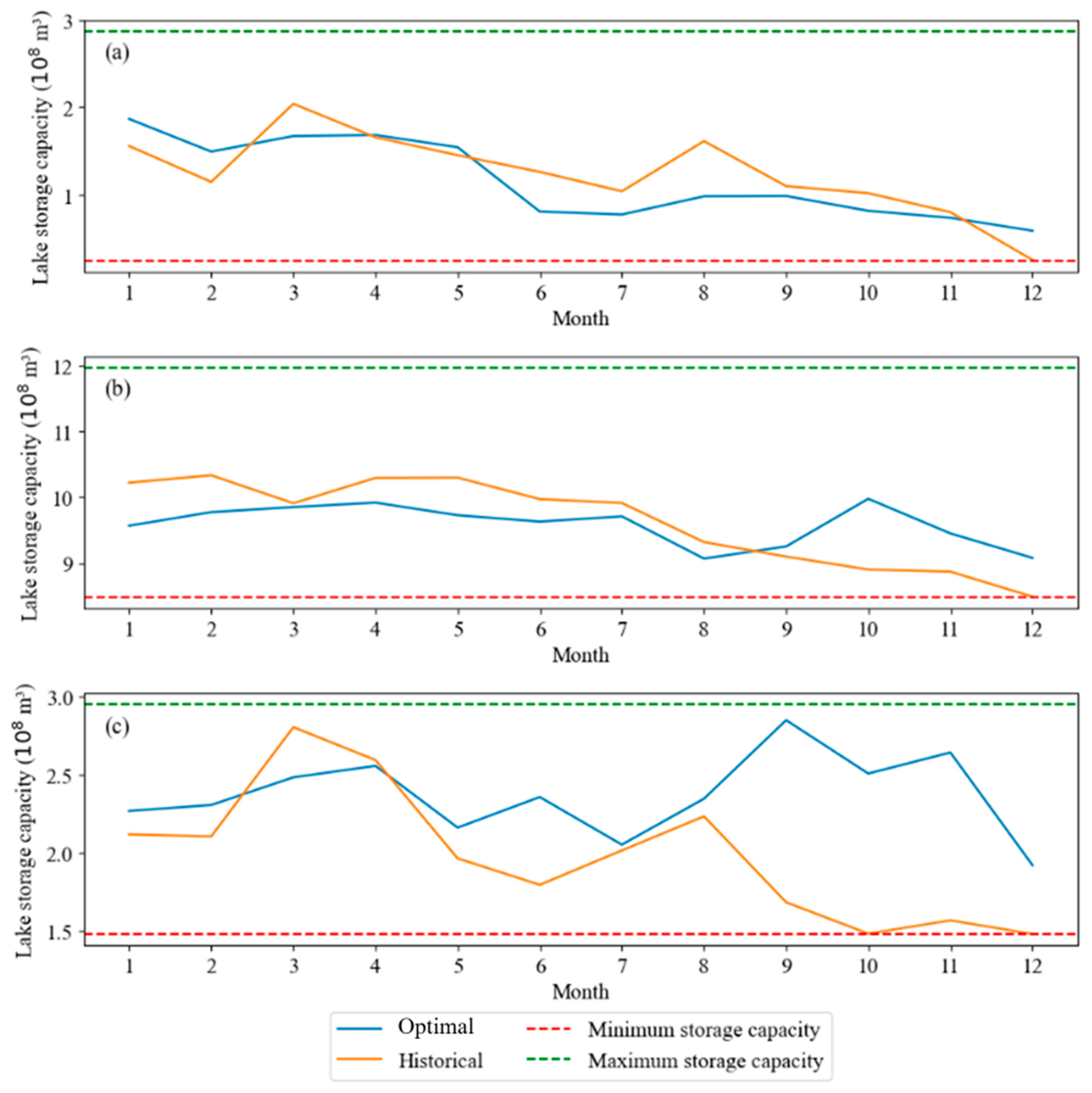
4.2. Comparison Between the Optimized Regulation Scheme and Historical Scheme

To further demonstrate the advantages of the established optimization model, this paper also simulates a traditional water diversion model. The model only strives to meet the downstream water demand and does not account for the stability of lake water levels. It does not adjust the water diversion from upstream or the water delivery to downstream appropriately based on changes in lake water levels. Figure 7 illustrates the changes in lake water levels corresponding to the optimal solutions derived from the two optimization models. Through comparison, it is evident that the blue line is significantly more stable than the orange line. Further variance calculations reveal that the water level variances of the three lakes are substantially reduced compared to those of the traditional method (Table 3). Specifically, the variance for Caizi Lake decreased by 24.8%, for Chaohu Lake by 76.0%, and for Wabu Lake by 62.6%. The findings indicate that the optimization model established in this study can effectively mitigate fluctuations in lake water levels during the operation of water diversion projects, thereby safeguarding the environmental stability of the habitats for the flora and fauna surrounding the lakes.
In contrast, traditional water diversion methods often prioritize maximizing the water supply for surrounding users, leading to the extraction of large volumes of water from lakes and causing water levels to approach the lower limit. During flood seasons, however, lake water levels tend to rise significantly. Such frequent fluctuations in lake water levels can cause severe damage to the local ecological environment. Therefore, it is demonstrated that the optimized scheduling system established in this study not only fully meets the water demands of users and enhances water diversion efficiency but also holds significant advantages in reducing the environmental impacts of human activities.

5. Discussion

Research on water resource scheduling is relatively extensive abroad. Hite et al. studied the issues of efficiency and fairness arising from inter-basin water diversion projects in the arid regions of the western United States. Scholars such as Mujumdar [28] employed the BSDP model to couple the uncertainty of inflow forecasts with actual conditions to guide the scheduling of reservoir systems. Dunia [29] proposed an integer linear programming decision support model with the goal of minimizing total costs, aimed at optimizing water resource treatment and allocation. S. Jamshid Mousavi [30] introduced a simulation–optimization framework focused on optimizing the scale, operation, and water allocation, with the Bashar to Zohreh inter-basin water diversion project serving as a practical case study. Scholars both domestically and internationally have conducted extensive research on the scheduling and water allocation optimization of inter-basin water diversion projects. Most studies establish optimization scheduling models based on the principle of water balance to rationally allocate water diversion and supply [17,18,31].
The A-YHWDP is a crucial component of the water resource supply for northern Anhui Province and parts of Henan Province. Exploring operational rules to enhance its long-term performance is of paramount importance. Therefore, we implemented joint scheduling with lake regulation, leveraging the lake storage capacity to simulate and generate optimal water allocation schemes. The joint optimal operation system is governed by three objectives: social demand (average water shortage rate), economic demand (total pumping volume), and ecological demand (uniformity of the lake storage capacity), with a particular focus on water scarcity. Here, scarce water resources are allocated to minimize the average water deficit across the system, making this method especially suitable for inter-basin water diversion projects with complex systems and a high water demand. Previous research on inter-basin water transfer has focused solely on social and economic demands [5,17,18,32], neglecting the ecological impacts. Large-scale water diversion may cause frequent lake water level fluctuations, negatively affecting surrounding flora and fauna habitats [33,34,35]. Hence, this study adopts an ecological conservation perspective, striving to maintain lake stability and thereby reduce the ecological impacts of large-scale water diversion on surrounding ecosystems. The applied multi-attribute decision-making framework provides optimal operational strategies with weighted preferences, catering to decision-makers with diverse priorities.

6. Conclusions

This paper developed a novel joint operation rule that integrates the regulatory role of lakes and formulated a multi-objective optimization model through a simulation–optimization methodology to identify the optimal operational strategies for the A-YHWDP. The following are the main conclusions:
(1)
The multi-objective optimization model introduced in this study successfully formulates joint operational guidelines for the A-YHWDP, achieving a water diversion capacity exceeding 1.9 × 10⁹ m3 and a water supply reliability rate of 99%.
(2)
The joint operation rules demonstrate significant advantages over conventional operation rules. The storage capacity of lakes along the route becomes more stable, with the variance in the storage capacity of Caizi Lake, Chao Lake, and Wabu Lake decreasing by 24.8%, 76%, and 62.6%, respectively.
(3)
Harnessing the regulatory potential of lakes can greatly enhance the efficiency of water resource management within the A-YHWDP. Compared to conventional operation rules, the joint operation rules provide more comprehensive regulation of the natural runoff of lakes.
In summary, the effective implementation of the optimized operational strategy in the A-YHWDP has validated the practicality of this research. It is anticipated that this approach can be further tested in other comparable basins globally to reaffirm its efficacy and demonstrate its adaptability across diverse scenarios. This will offer scientific insights and practical guidance for long-distance water diversion projects between basins.

Author Contributions

Conceptualization, Q.H.; methodology, X.Q.; software, Q.H.; validation, Z.G., investigation, B.L., X.C. and Y.O.; resources, B.L.; data curation, B.L.; writing—original draft preparation, X.Q.; writing—review and editing, Q.H. and D.W.; visualization, Dejian Wang.; supervision, X.C.; funding acquisition, X.Q., Q.H., B.L., Y.O. and D.W. All authors have read and agreed to the published version of the manuscript.

Funding

This research was funded by Project on Delineation of Water Resource Projection Areas, Early-Warning System for Major Sudden Water Pollution Incidents, and Planning for the Projection of Water Sources Along Water Transmission Routes of the Diversion of Yangtze River to the Huaihe Project (Anhui Section) (No. YJJH-ZT-ZX-20230706545); Key Natural Science Research Project of Bengbu University (No. 2023ZR02zd); Bengbu University Applied Project (High-level Talent Research Fund) (No. 2024YYX66QD; No. 2024YYX65QD; No. 2025GQD039) and Key Projects of Natural Science Research in Universities of Anhui Province (No. 2023AH052941).

Data Availability Statement

The raw data supporting the conclusions of this article will be made available by the authors on request.

Conflicts of Interest

Author Xuebao Chen was employed by the company Anhui Provincial Group Limited for Yangtze-to-Huaihe Water Diversion. Author Zhiyajng Guo was employed by the company Anhui Survey & Design Institute of Water Resources & Hydropower Co., Ltd. The remaining authors declare that the research was conducted in the absence of any commercial or financial relationships that could be construed as a potential conflict of interest.

References

  1. Di, D.; Shi, Q.; Wu, Z.; Wang, H. Sustainable Management and Environmental Protection for Basin Water Allocation: Differential Game-based Multiobjective Programming. Water Resour. Manag. 2022, 37, 1–20. [Google Scholar] [CrossRef]
  2. Lin, P.; You, J.; Gan, H.; Jia, L. Rule-Based Object-Oriented Water Resource System Simulation Model for Water Allocation. Water Resour. Manag. 2020, 34, 3183–3197. [Google Scholar] [CrossRef]
  3. Valerio, C.; Giuliani, M.; Castelletti, A.; Garrido, A.; De Stefano, L. Multi-objective optimal design of interbasin water transfers: The Tagus-Segura aqueduct (Spain). J. Hydrol. Reg. Stud. 2023, 46, 101339. [Google Scholar] [CrossRef]
  4. Guo, L.; Zhu, W.; Wei, J.; Wang, L. Water demand forecasting and countermeasures across the Yellow River basin: Analysis from the perspective of water resources carrying capacity. J. Hydrol. Reg. Stud. 2022, 42, 101148. [Google Scholar] [CrossRef]
  5. Yan, B.; Jiang, H.; Zou, Y.; Liu, Y.; Mu, R.; Wang, H. An integrated model for optimal water resources allocation under “3 Redlines” water policy of the upper Hanjiang river basin. J. Hydrol. Reg. Stud. 2022, 42, 101167. [Google Scholar] [CrossRef]
  6. Li, Y.; Cui, Q.; Li, C.; Wang, X.; Cai, Y.; Cui, G.; Yang, Z. An improved multi-objective optimization model for supporting reservoir operation of China’s South-to-North Water Diversion Project. Sci. Total Environ. 2017, 575, 970–981. [Google Scholar] [CrossRef]
  7. Liu, Y.; Wang, M.; Webber, M.; Zhou, C.; Zhang, W. Alternative water supply solutions: China’s South-to-North-water-diversion in Jinan. J. Environ. Manag. 2020, 276, 111337. [Google Scholar] [CrossRef]
  8. Ouyang, S.; Qin, H.; Shao, J.; Lu, J.; Bing, J.; Wang, X.; Zhang, R. Multi-objective optimal water supply scheduling model for an inter-basin water transfer system: The South-to-North Water Diversion Middle Route Project, China. Water Supply 2020, 20, 550–564. [Google Scholar] [CrossRef]
  9. Li, D.; Zuo, Q.; Wu, Q.; Li, Q.; Ma, J. Achieving the tradeoffs between pollutant discharge and economic benefit of the Henan section of the South-to-North Water Diversion Project through water resources-environment system management under uncertainty. J. Clean. Prod. 2021, 321, 128857. [Google Scholar] [CrossRef]
  10. Zhao, S.; Liu, W.; Zhu, M.; Ma, Y.; Li, Z. A priority-based multi-objective framework for water resources diversion and allocation in the middle route of the South-to-North Water Diversion Project. Socio-Econ. Plan. Sci. 2021, 78, 101085. [Google Scholar] [CrossRef]
  11. Bai, X.; Li, W.; Lin, X.; Han, L.; Ming, D. Reconciling regional water diversion and urban growth policies to protect groundwater across a large urban region in China. J. Hydrol. 2022, 612, 128094. [Google Scholar] [CrossRef]
  12. Ming, B.; Zhong, H.; Zhang, W.; Yang, G.; Zhao, Z.; Huang, Q. Deriving operating rules for inter-basin water transfer projects incorporating a scenario reduction strategy. J. Hydrol. 2023, 624, 129854. [Google Scholar] [CrossRef]
  13. Fenicia, F.; Meißner, D.; McDonnell, J.J. Modeling streamflow variability at the regional scale: (2) Development of a bespoke distributed conceptual model. J. Hydrol. 2022, 605, 127286. [Google Scholar] [CrossRef]
  14. Zhu, F.; Zeng, Y.; Wang, Y.; Han, M.; Liu, W.; Fan, Y.; Ben, M.; Zhong, P.-A. A stochastic decision-making framework for optimal multi-objective reservoir operation accounting for the tracking of uncertainty propagation and evolution from multiple sources. J. Hydrol. 2025, 654, 132811. [Google Scholar] [CrossRef]
  15. Khanaum, M.M.; Qi, T.; Chu, X. Dynamic Partial Contributing Area (DPCA) approach: Improved hydrologic modeling for depression-dominated watersheds. J. Hydrol. 2025, 658, 133077. [Google Scholar] [CrossRef]
  16. Liu, Y.; Zheng, H.; Wan, W.; Zhao, J. Optimal operation toward energy efficiency of the long-distance water transfer project. J. Hydrol. 2023, 618, 129152. [Google Scholar] [CrossRef]
  17. Zhou, B.-Y.; Fang, G.-H.; Li, X.; Zhou, J.; Zhong, H.-Y. Joint optimal operation of the South-to-North Water Diversion Project considering the evenness of water deficit. Hydrol. Earth Syst. Sci. 2024, 28, 817–832. [Google Scholar] [CrossRef]
  18. Zhong, H.; Liao, T.; Fang, G.; Ren, K.; Zhang, S. Exploring optimal joint operating rules for large-scale inter-basin water transfer projects with multiple water sources, diversion routes, and water demand areas. J. Hydrol. Reg. Stud. 2023, 49, 101504. [Google Scholar] [CrossRef]
  19. Li, C.; Li, H.; Zhang, Y.; Zha, D.; Zhao, B.; Yang, S.; Zhang, B.; de Boer, W.F. Predicting hydrological impacts of the Yangtze-to-Huaihe Water Diversion Project on habitat availability for wintering waterbirds at Caizi Lake. J. Environ. Manag. 2019, 249, 109251. [Google Scholar] [CrossRef]
  20. An, L.; Liao, K.; Zhu, L.; Zhou, B. Influence of river-lake isolation on the water level variations of Caizi Lake, lower reach of the Yangtze River. J. Geogr. Sci. 2021, 31, 551–564. [Google Scholar] [CrossRef]
  21. Ding, W.; Shi, G.; Zha, H.; Miao, H.; Lu, M.; Jin, J. Ecological impacts and supply demand evolution of the Yangtze to Huaihe water transfer project in Anhui section. Sci. Rep. 2024, 14, 20311. [Google Scholar] [CrossRef]
  22. Wu, J.; Xu, J.; Lu, M.; Ming, H. An integrated modelling framework for optimization of the placement of grey-green-blue infrastructure to mitigate and adapt flood risk: An application to the Upper Ting River China. J. Hydrol. Reg. Stud. 2025, 57, 102156. [Google Scholar] [CrossRef]
  23. Jin, X.; Fang, D.; Chen, B.; Wang, H. Multiobjective layout optimization for low impact development considering its ecosystem services. Resour. Conserv. Recycl. 2024, 209, 107794. [Google Scholar] [CrossRef]
  24. Bahrami, M.; Talebbeydokhti, N.; Rakhshandehroo, G.; Nikoo, M.R.; Alamdari, N. Integrated Multisource Data Assimilation and NSGA-II Multiobjective Optimization Framework for Streamflow Simulations. J. Hydrol. Eng. 2024, 29, 04024040. [Google Scholar] [CrossRef]
  25. Wang, Y.; Guo, S.S.; Guo, P. Crop-growth-based spatially-distributed optimization model for irrigation water resource management under uncertainties and future climate change. J. Clean. Prod. 2022, 345, 131182. [Google Scholar] [CrossRef]
  26. Mahmoud, A.; Hu, T.; Jing, P.; Liu, Y.; Li, X.; Wang, X. Enhancing interpretability of AI models in reservoir operation simulation: Exploring and mitigating principal inconsistencies through theory-guided multi-objective artificial neural networks. J. Hydrol. 2024, 639, 131618. [Google Scholar] [CrossRef]
  27. Han, Q.; Xue, L.; Liu, Y.; Yang, M.; Chu, X.; Liu, S. Developing a multi-objective simulation-optimization model for ecological water conveyance in arid inland river basins. J. Hydrol. Reg. Stud. 2023, 50, 101551. [Google Scholar] [CrossRef]
  28. Mujumdar, P.P.; Nirmala, B. A bayesian stochastic optimization model for a multi-reservoir hydropower system. Water Resour. Manag. 2007, 21, 1465–1485. [Google Scholar] [CrossRef]
  29. Abdulbaki, D.; Al-Hindi, M.; Yassine, A.; Abou Najm, M. An optimization model for the allocation of water resources. J. Clean. Prod. 2017, 164, 994–1006. [Google Scholar] [CrossRef]
  30. Mousavi, S.J.; Anzab, N.R.; Asl-Rousta, B.; Kim, J.H. Multi-Objective Optimization-Simulation for Reliability-Based Inter-Basin Water Allocation. Water Resour. Manag. 2017, 31, 3445–3464. [Google Scholar] [CrossRef]
  31. Long, Y.; Liu, Y.; Zhao, T.; Zhang, Z.; Lei, X.; Yang, Y. Optimal allocation of water resources in the middle route of south-to-north water diversion project based on multi-regional input-output model. J. Hydrol. 2024, 637, 131381. [Google Scholar] [CrossRef]
  32. Zhang, S.; Wen, X.; Zhang, R.; Miao, W.; Gan, Z. An optimal allocation model based on the regional ecological water requirements and multi-water supply characteristics: A case study of Shandong Province, China. J. Hydrol. Reg. Stud. 2023, 49, 101513. [Google Scholar] [CrossRef]
  33. Anderson, O.; Harrison, A.; Heumann, B.; Godwin, C.; Uzarski, D. The influence of extreme water levels on coastal wetland extent across the Laurentian Great Lakes. Sci. Total Environ. 2023, 885, 163755. [Google Scholar] [CrossRef] [PubMed]
  34. Hou, P.; Weidman, R.P.; Liu, Q.; Li, H.; Duan, L.; Zhang, X.; Liu, F.; Gao, Y.; Xu, J.; Li, H.; et al. Recent water-level fluctuations, future trends and their eco-environmental impacts on Lake Qinghai. J. Environ. Manag. 2023, 333, 117461. [Google Scholar] [CrossRef]
  35. Li, X.; Hu, B.; Qi, S.; Luo, J. The Influence of Short-Term Water Level Fluctuations on the Habitat Response and Ecological Fragility of Siberian Cranes in Poyang Lake, China. Remote Sens. 2024, 16, 4431. [Google Scholar] [CrossRef]
Figure 1. Location diagram of the A-YHWDP.
Water 17 01286 g001
Figure 2. The topology diagram of A-YHWDP.
Water 17 01286 g002
Figure 3. The water level–storage capacity curves of the lakes: (A) Caizi Lake, (B) Chao Lake, and (C) Wabu Lake.
Water 17 01286 g003
Figure 5. The Pareto frontier of the optimized water diversion scheme (the red dot represents the optimal solution).
Water 17 01286 g005
Figure 6. Time series of various decision variables. (a) Zongyang Pumping Station; (b) Fenghuangjing Pumping Station; (c) Caizi Lake; (d) Chao Lake; (e) Wabu Lake.
Water 17 01286 g006
Figure 7. The comparison of the storage capacity changes in the lakes between the optimized method and the historical methods is as follows: (a) Caizi Lake, (b) Chao Lake, and (c) Wabu Lake.
Water 17 01286 g007
Table 1. Characteristic water levels of lakes (m).
MonthCaizi LakeChao LakeWabu Lake
Upper Limit Water LevelLower Limit Water LevelUpper Limit Water LevelLower Limit Water LevelUpper Limit Water LevelLower Limit Water Level
19.17.17.16.618.417.4
29.17.17.16.618.417.4
39.17.17.16.618.417.4
49.17.17.16.618.417.4
59.17.16.66.618.417.4
69.17.16.66.118.417.4
79.17.16.66.118.417.4
89.17.16.66.118.417.4
99.17.16.66.618.417.4
109.17.17.16.618.417.4
119.17.17.16.618.417.4
129.17.17.16.618.417.4
Table 2. The objective function values of the optimal solution.
Objective FunctionUnitValue
Total pumped water109 m31.84
Total water deficit%4.46
Storage capacity variance10151.06
Table 3. The comparison of variance in the lake storage capacity changes during the water diversion period.
LakeHistoricalOptimalDecrement
Caizi Lake20.815.624.8%
Chao Lake40.19.676.0%
Wabu Lake17.66.662.6%
Disclaimer/Publisher’s Note: The statements, opinions and data contained in all publications are solely those of the individual author(s) and contributor(s) and not of MDPI and/or the editor(s). MDPI and/or the editor(s) disclaim responsibility for any injury to people or property resulting from any ideas, methods, instructions or products referred to in the content.

