1. Introduction
Flash floods represent a significant environmental hazard, with the potential to overwhelm urban drainage systems [
1]. These meteorological events are characterized by short-duration, high-intensity rainfall that is challenging to monitor and predict [
2]. Flash floods are particularly prevalent in arid regions, where they have caused a substantial loss of human life, damage to infrastructure, and economic disruption. With the increasing global population and the exacerbating effects of climate change, the intensity and frequency of flash floods have altered significantly [
3]. The socio-economic and infrastructural impact of flash floods is profound, affecting buildings, transportation networks, and human settlements. Flooding, often induced by climate change and extreme precipitation, results in the temporary inundation of valley plains and drainage systems. Such hydrometeorological events affect approximately one-third of the Earth’s surface, where over 70% of the global population resides [
4]. In arid regions, flash floods are predominantly observed in coastal zones, mountainous valleys (wadi courses), and low-lying urban areas due to significant surface runoff, leading to extensive infrastructure damage and loss of life [
5].
The United Arab Emirates (UAE), particularly Al Ain, has experienced a rise in extreme rainfall events, leading to increased flash-flood occurrences [
6,
7,
8]. Alhosani et al. [
7] analyzed four major rainfall events (2007–2020) and found record-breaking rainfall intensities (up to 195.7 mm/h), which caused severe urban flooding despite low runoff coefficients (0.11–3.14%), highlighting the impact of rapid urbanization on flood risks. The study also identified limitations in satellite precipitation data, which often misrepresent rainfall intensity, affecting hydrological model accuracy. Similarly, Alsumaiti et al. [
8] mapped flood hazard levels in Al Ain, finding 32% of the city at moderate risk and 5% at high risk. Using remote sensing and machine learning, the study integrated building age, land use, elevation, and population density into a flood hazard map, emphasizing the need for GIS-based flood risk assessments in urban planning and disaster mitigation.
Moreover, Hussein et al. [
9] demonstrated that urbanization along coastal areas has significantly intensified flood risks, with hydrological models confirming the impact of land use changes on flood magnitude. Their study found that built-up areas increased by over 24% between 1996 and 2006 and by 28% from 2006 to 2016, directly influencing flood potential. Similarly, Sarrau et al. [
10] emphasized the role of GIS-based climate change modeling, particularly in assessing rising sea levels and extreme weather events.
The advent of remote sensing data and the application of machine learning algorithms have significantly enhanced the ability to predict flash floods at a regional scale [
4,
11,
12]. In recent years, flood forecasting has gained prominence due to its capability to provide real-time warnings for regions susceptible to flash flooding. This process involves estimating runoff volumes, quantifying stored water amounts, and assessing the likelihood of flood events [
11]. Consequently, researchers and policymakers frequently employ computer-based hydraulic models and drainage basin analyses to qualitatively evaluate flood risks [
13]. Hydraulic modeling is instrumental in streamflow prediction, flood simulation, and qualitative flood assessment, providing crucial information for flood management and mitigation strategies [
4].
Accurate streamflow prediction facilitates a comprehensive understanding of hydraulic environments and aids in preventing infrastructural damage [
14]. Traditional hydrological models such as the Hydrologic Engineering Center’s River Analysis System (HEC-RAS) and the Hydrologic Modeling System (HEC-HMS) have been widely employed to simulate surface runoff based on precipitation patterns [
4]. Globally, various flash-flood models have been developed to estimate river discharge and streamflow [
15], integrating Geographic Information Systems (GISs), remote sensing, and rainfall-runoff modeling in HEC-HMS [
11]. These models incorporate geohydrological parameters, magnitude indexing, and geospatial technology for flash-flood inundation mapping, flood shelter site selection, and flood risk assessment [
13]. Hydrological parameters such as hourly rainfall intensity and surface runoff velocity are crucial for these models [
16]. Additionally, the integration of HEC-RAS and HEC-GeoRAS has been widely used by researchers [
4,
17] to model and analyze flood risk and river discharge in arid regions. In areas lacking gauging stations and meteorological data, deep learning models offer a promising alternative for improving flood forecasting by modeling rainfall-runoff relationships [
11].
Accurate runoff predictions are critical for effective flood management. The application of artificial intelligence (AI)-driven models has garnered substantial interest in hydrological studies, particularly in rainfall-runoff modeling [
18]. Previous studies emphasized the potential of machine learning in hydrological modeling. Hearth et al. [
19] employed machine learning techniques to model rainfall-runoff dynamics, demonstrating their effectiveness in complex hydrological environments. Similarly, Mohammadi [
20] reviewed multiple machine learning techniques for flash-flood modeling, highlighting their applicability in flood event prediction. Several regional studies have applied innovative and advanced flood prediction models across diverse hydrological sites. Oluwadamilola and Akinyede [
21] applied 2D CNNs for urban flood susceptibility mapping, integrating spatial datasets with high accuracy. In Bangladesh, Rajab et al. [
22] applied machine learning to historical climate records for efficient flood forecasting. Steirou et al. [
23] established seasonal flood probability models in Europe, employing catchment and climate data. Classical methods also remain appropriate; Dahal and Kojima [
24] evaluated traditional models in Bhutan, while Brunner [
25] emphasized the limitations and prospects of merging empirical and physical models for advanced flood prediction.
Machine learning and deep learning models have been extensively applied for runoff prediction [
26,
27], although these models are highly data-intensive and require extensive datasets. AI-based models capture the nonlinear relationships between rainfall and runoff, enhancing predictive capabilities. Some of the most widely used deep learning architectures include Extreme Gradient Boosting (XGBoost), Recurrent Neural Networks (RNNs), Artificial Neural Networks (ANNs), and the Random Forest (RF) algorithm [
28,
29,
30,
31]. These data-driven approaches improve model accuracy and robustness, optimizing flood risk assessments.
Although Convolutional Neural Networks (CNNs) are primarily utilized in image processing, they have also been applied to sequential data analysis, including weather predictions, stock market forecasts, audio signal processing, and industrial process monitoring [
18,
32,
33]. RNNs have been extensively used in speech-to-text applications [
34], environmental monitoring of air quality, humidity, and temperature [
35], as well as in healthcare for analyzing bioelectric signals [
36].
Shekar et al. [
18] integrated CNN and RNN architectures to leverage the feature extraction capabilities of CNNs with the sequential modeling strengths of RNNs. While their model demonstrated high accuracy in runoff prediction, the inclusion of additional meteorological variables, such as temperature extremes, could further enhance predictive performance. To address the limitations in existing flash-flood-runoff models and to improve the integration of deep learning in hydrological forecasting, this study addresses the following improvements:
Improving predictive precision by integrating spatial, temporal, and dynamic system modeling via a hybrid CNN-RNN with the Neural ODE framework.
Bridging the gap in the outdated hydrological models and advanced deep learning methods by modeling continuous-time dynamics, which are mostly not included in discrete methods.
Enhancing flood resilience in data-scarce and flash-flood-prone areas, such as the UAE, where well-timed and precise runoff forecasts are critical.
Integrating weather parameters and temperature extremes to improve the physical relevance of deep learning predictions.
Therefore, this study introduces the application of Neural Ordinary Differential Equations (Neural ODEs) in conjunction with CNN and RNN architectures. Neural ODEs exhibit superior capabilities in modeling complex, nonlinear data structures, thereby improving the predictive accuracy of natural system simulations. The proposed framework integrates CNNs and RNNs for feature extraction and sequential processing, while Neural ODEs model the underlying dynamics of the extracted features. This novel approach is examined in this study and compared against conventional deep learning methodologies to assess its efficacy in flash-flood prediction.
2. Materials and Methods
2.1. Case Study Description
Al Ain is a city located in the Emirate of Abu Dhabi, situated along the border with Oman and adjacent to the Hafeet Mountain [
37]. The region’s distinctive geography, characterized by rugged mountains and vast desert plains, significantly influences its hydrological processes. Rainfall in Al Ain is primarily driven by cloud formations associated with depressions in the Indian Ocean, resulting in sporadic yet intense precipitation events [
38]. The area’s geological composition, comprising porous limestone in the Hafeet Mountain and sandy soils in the plains, affects water absorption and runoff patterns during these events [
39].
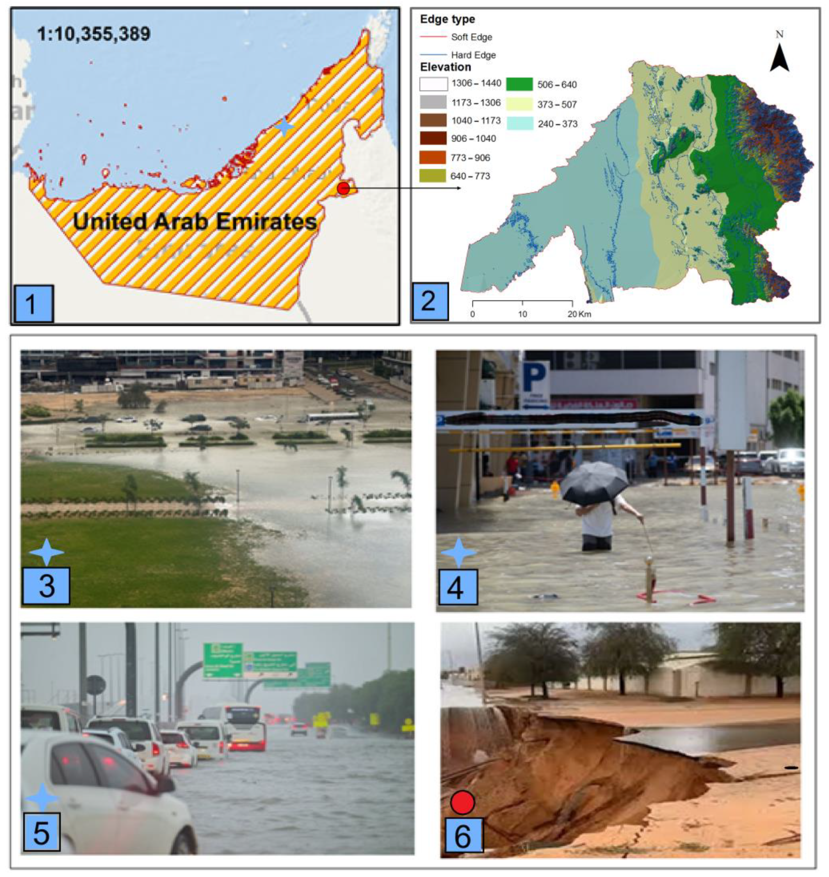
Although rainfall in the UAE is generally low, flash floods occur due to rare heavy rainfall events that exceed the capacity of natural valleys and drainage systems. The most severe recent flood occurred on 16 April 2024, with 254 mm of rain in less than 24 h, marking the highest recorded rainfall since 1949 [
8]. These extreme weather events have led to significant damage to buildings, roads, farms, and other infrastructure, exacerbated by urban expansion and the absence of hydraulic-control structures at natural drainage outlets (
Figure 1).
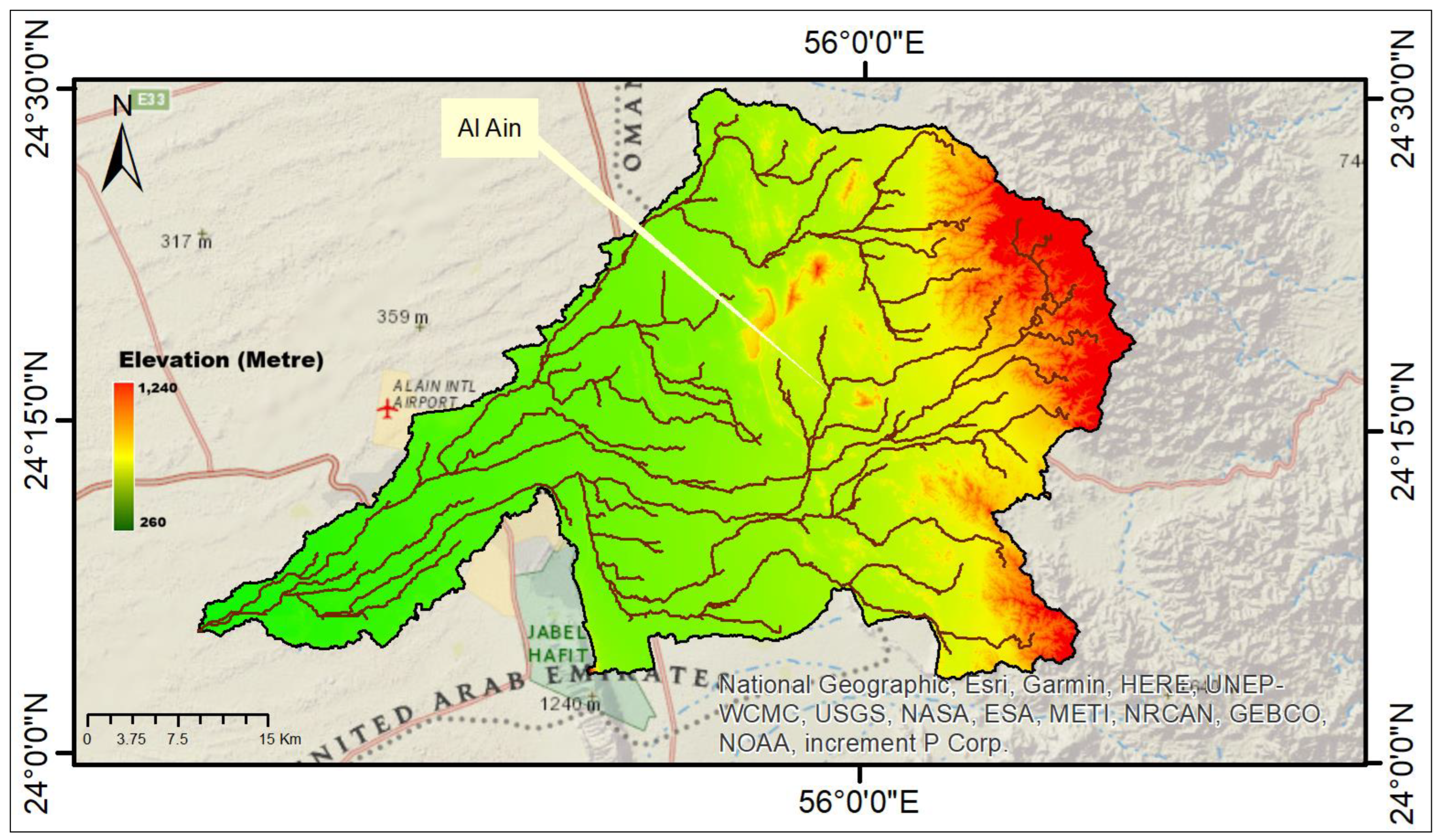
Given the increasing frequency of extreme weather events and the growing urbanization in arid regions, understanding and predicting runoff patterns is crucial for flood risk management, infrastructure planning, and environmental sustainability. While traditional event-based rainfall studies are well-documented in the literature, they often fail to capture the complex interactions between precipitation, terrain characteristics, and runoff dynamics. This study differentiates itself by employing deep learning models to predict runoff for flash-flood events, integrating advanced techniques such as Convolutional Neural Networks (CNNs), Recurrent Neural Networks (RNNs), and Neural Ordinary Differential Equations (ODEs) to enhance predictive accuracy. The study focuses on an Al Ain catchment (
Figure 1), delineated using a 25 m resolution ASTER DEM, with hydrological analyses conducted using ArcMap’s hydrology libraries (ArcMap version 10.8.2). ASTER was chosen due to its worldwide accessibility, better integration into hydrological modeling methods, and confirmed efficiency in terrain study for semi-arid and mountainous areas. Despite the accessibility of 10 m DEMs, ASTER DEM has been used in various similar studies due to its resolution sufficiency and availability (Tachikawa et al. [
1]; Grohmann and Riccomini [
2]). By leveraging six years of historical data and a real-world flash-flood event from April 2024, this research provides valuable insights into flood forecasting methodologies, contributing to more effective disaster preparedness and early warning systems in vulnerable regions.
Al Ain is characterized by a warm to hot desert climate, with average temperatures ranging from approximately 18 °C during the winter months to around 40 °C in the summer. Humidity levels can reach up to 60% during peak summer months, further intensifying the arid conditions. Precipitation in Al Ain is infrequent and primarily occurs during the winter season, with mean monthly rainfall ranging between 5 and 20 mm. On an annual scale, rainfall distribution varies significantly across the region, with precipitation levels ranging from approximately 50 mm in the desert areas to 120 mm in the mountainous regions near Hafeet Mountain. Furthermore, the neighboring Emirate of Fujairah (Fujairah Catchment—25.12° N, 56.33° E—elevation: 122 m—area: 34 km
2), which shares similar climatic and topographical conditions, has experienced significant flood events in the past, as detailed in
Table 1.
The climatic conditions in Al Ain are characterized by high temperatures and limited rainfall, presenting significant challenges for water resource management and flood risk assessment. The region’s geological composition, consisting of porous limestone in the Hafeet Mountains and sandy soils in the surrounding plains, plays a crucial role in determining water absorption and runoff dynamics during precipitation events. A comprehensive understanding of these climatic and geological factors is essential for developing effective mitigation strategies to address both prolonged drought conditions and sudden, intense rainfall events.
This study aims to develop a deep learning model to analyze the recent catastrophic flash-flood event that occurred on 15–16 April 2024. To achieve this, datasets were acquired for precipitation and runoff from ERA5, while the Digital Elevation Model (DEM) data were sourced from ALOS PALSAR (
Table 2). By integrating these datasets, this study seeks to enhance predictive capabilities for flash-flood modeling, contributing to improved flood forecasting and risk management in arid and semi-arid regions.
2.2. Al Ain Catchment Development
The topography of the study area was represented using a high-resolution 12.5 m Digital Elevation Model (DEM) obtained from the Advanced Land Observation System (ALOS) PALSAR, sourced from the Alaska Satellite Facility website. This DEM, referenced to the EGM96 vertical datum, was projected in ArcGIS v10.8.2 using the Universal Transverse Mercator (UTM) Zone 40N projection and the WGS 1984 datum to ensure spatial accuracy and consistency in the analysis. To delineate the watershed for the Al Ain study area, the ArcGIS hydrology toolset was employed. A watershed, defined as the upslope area contributing runoff to a common drainage outlet, can encompass multiple subbasins that further refine hydrological modeling. Utilizing the 12.5 m ALOS PALSAR DEM, the watershed was delineated through hydrologic modeling tools available in the Spatial Analyst extension of ArcGIS. The extracted basin polygons were refined using the clip tool, and a threshold of 38,000 was applied to generate the stream network system via the map algebra tool. The resulting stream network raster was subsequently converted into a polyline layer, facilitating the development of a detailed stream network and well-defined watershed basins for the study area (
Figure 2).
Historic rainfall and runoff data from ERA5 hourly datasets, covering the period from 1 January 2016 to 31 December 2022, were validated against ground-based observations to ensure data reliability. The observed rainfall was modeled using the Hydrologic Engineering Center-Hydrologic Modeling System (HEC-HMS), and the resulting runoff simulations were compared with ERA5-derived runoff values. Moreover, to validate the model performance, five-fold cross-validation was used to reduce bias and to ensure robustness due to overfitting. Upon successful validation, this dataset was employed as training data for the developed deep learning model.
For model testing, precipitation data from the recent flash-flood event (14–30 April 2024) was utilized to predict runoff. The predicted runoff values were subsequently compared against observed runoff measurements to evaluate the model’s performance and accuracy in forecasting flash-flood events.
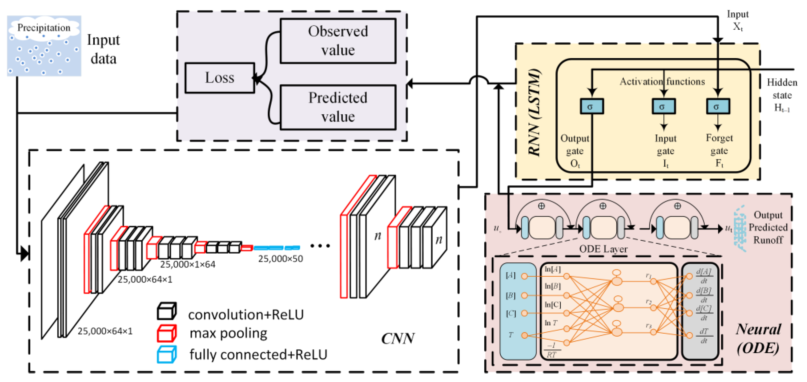
2.3. Theory of Deep Learning Model
This study employs a novel approach by integrating Convolutional Neural Networks (CNNs), Recurrent Neural Networks (RNNs), and Neural Ordinary Differential Equations (Neural ODEs) to enhance feature extraction, temporal processing, and dynamic modeling for runoff prediction. Initially, the models were individually evaluated, including CNN-RNN, Neural ODE, and the combined CNN-RNN-Neural ODE framework. The dataset used in this study consists of precipitation records applied to rainfall-runoff modeling.
Neural ODE represents an advanced deep learning methodology that models system dynamics as a continuous function over time [
42]. In traditional Ordinary Differential Equations (ODEs), the rate of change in a state variable
y over time
t is expressed as follows, using Equation (1):
In the context of Neural ODEs, the function
f is parameterized as a neural network with trainable weights
Θ, leading to the following formulation in Equation (2):
where
is a neural network that takes the current state variables
y and
t as inputs and returns their derivatives
. To solve the Neural ODE, Equation (2) is integrated over time. Given an initial state
, the future state
is determined by integrating the neural network output as follows (Equation (3)):
This integration can be easily performed using ‘torchdiffeq’ library in Python v0.2.5. The integration of the CNN, RNN, and Neural ODE allows for a comprehensive modeling approach that leverages the spatial feature extraction capabilities of CNNs, the temporal sequence learning of RNNs, and the dynamic system modeling of Neural ODEs. In this framework, supposing that
x is the input data (precipitation in rainfall-runoff modeling),
h = CNN-RNN(
x) is the extracted features by the model, and
is the parameter of the Neural ODE, the combined model can be written as shown in Equation (4):
Following this integration,
gives the output state at a different time and the final prediction (in this case runoff) using a fully connected layer is as shown in Equation (5):
During training and testing phases, the CNN-RNN model extracts features using precipitation data through , model dynamics are calculated using Neural ODEs, and thus runoff is predicted. The predicted runoff is then compared to the actual using various evaluation metrics to assess the model’s performance. This integrated approach enables the model to effectively capture both spatial dependencies (via CNN) and temporal dependencies (via RNN and ODE), making it highly suitable for complex time-series predictions of runoff based on precipitation inputs.
Hyperparameters for the CNN-RNN and Neural ODE models were chosen by a grid search and manual tuning. Important factors such as layer numbers, filter sizes, hidden units, and learning values were adjusted. To avoid overfitting, k-fold cross-validation, dropout, early stopping, and L2 regularization were utilized during model training.
The model integrates CNN, RNN (specifically LSTM), and Neural ODE (
Figure 3) to create a comprehensive approach for runoff prediction. The CNN extracts relevant features from the precipitation data, the RNN captures temporal dependencies and patterns in the extracted data, and the Neural ODE component models the dynamic behavior to predict the runoff. This integrated architecture makes the developed model more robust and comprehensive.
3. Results and Discussion
The six-year dataset spanning from 2016 to 2022 was utilized as the training period, while the April 2024 dataset was designated for model testing. The training and testing phases were conducted for three distinct deep learning models: the integrated CNN with RNN (CNN-RNN), the standalone Neural ODE model, and the integrated CNN-RNN with the Neural ODE framework. These models were evaluated based on their predictive accuracy and stability.
Table 3 presents a comprehensive comparison of model accuracy and stability metrics, providing insights into their performance and reliability for runoff prediction.
The CNN-RNN model displayed strong predictive performance, achieving an R2 value of 0.96, indicating that 96% of the variance in runoff could be explained by the model. The Root Mean Square Error (RMSE) of 3.74 × 10⁶ and the Mean Absolute Error (MAE) of 1.66 × 10⁶ demonstrate that the model’s predictions closely align with observed values. The small magnitude of these error metrics confirms that the model is capable of capturing the underlying runoff patterns effectively, with only minor discrepancies between predicted and true values. Additionally, the low MAE relative to RMSE suggests that the errors are generally small and consistent, with limited influence from larger outliers. Additionally, the Nash–Sutcliffe efficiency (NSE) value of 0.96 confirms the robustness of the model, reinforcing its reliability for runoff prediction. However, the Percent Bias (PBIAS) value of −13.73 indicates a slight underestimation bias in the model’s predictions.
The Neural ODE model further enhanced predictive accuracy compared to the CNN-RNN model, attaining an improved R2 value of 0.97, signifying a better fit to the data. The RMSE and MAE values, at 3.41 × 10⁶ and 1.85 × 10⁶, respectively, are lower than those obtained for the CNN-RNN model, indicating more precise predictions. Similarly, the NSE value of 0.97 reaffirms the model’s reliability. However, a PBIAS of −25.48 suggests a more pronounced underestimation bias relative to the CNN-RNN model.
The integrated CNN-RNN-Neural ODE model demonstrated the best performance among all tested models, achieving the highest R2 value of 0.98, indicating that 98% of the variance in runoff is accurately captured. This superior fit is further supported by the lowest RMSE and MAE values recorded, at 2.87 × 10⁶ and 1.13 × 10⁶, respectively, reflecting the highest level of predictive accuracy. The NSE value of 0.98 further affirms the model’s reliability. Moreover, the PBIAS value of −8.38 suggests a significantly reduced underestimation bias, making this integrated approach the most balanced in terms of prediction accuracy and error minimization. Overall, the CNN-RNN model achieved an R2 of 0.96 and NSE of 0.96, while the standalone Neural ODE model yielded an R2 = 0.97 and NSE = 0.97. Our proposed hybrid model improved performance significantly with an R2 = 0.98 and NSE = 0.98, reflecting both improved temporal continuity and spatial sensitivity. These results highlight the effectiveness of integrating the CNN, RNN, and Neural ODE for runoff prediction, demonstrating an optimal balance between precision and bias reduction.
3.1. Modeling Using CNN-RNN
The CNN-RNN model leverages the strengths of Convolutional Neural Networks (CNNs) for spatial feature extraction and Recurrent Neural Networks (RNNs) for capturing temporal dependencies in precipitation data. CNNs are employed to extract meaningful spatial patterns, while RNNs, specifically Long Short-Term Memory (LSTM) layers, capture long-term dependencies in sequential data, making them well-suited for runoff prediction.
The modeling process begins with preprocessing precipitation data through a Conv1d layer, which applies convolution operations to detect spatial features within the input dataset. This layer is crucial for identifying significant spatial patterns in precipitation events. Following this, the MaxPool1d layer performs down-sampling, reducing the dimensionality of the extracted features while retaining only the most dominant spatial characteristics. This step not only reduces computational complexity but also ensures that the extracted features are the most relevant for subsequent processing.
The extracted spatial features from the CNN are subsequently fed into the RNN framework, specifically Long Short-Term Memory (LSTM) layers. LSTMs are well-suited for handling sequential data, as they effectively learn and retain long-term dependencies. In this model, LSTMs capture temporal relationships in precipitation data, which are essential for accurately predicting runoff dynamics.
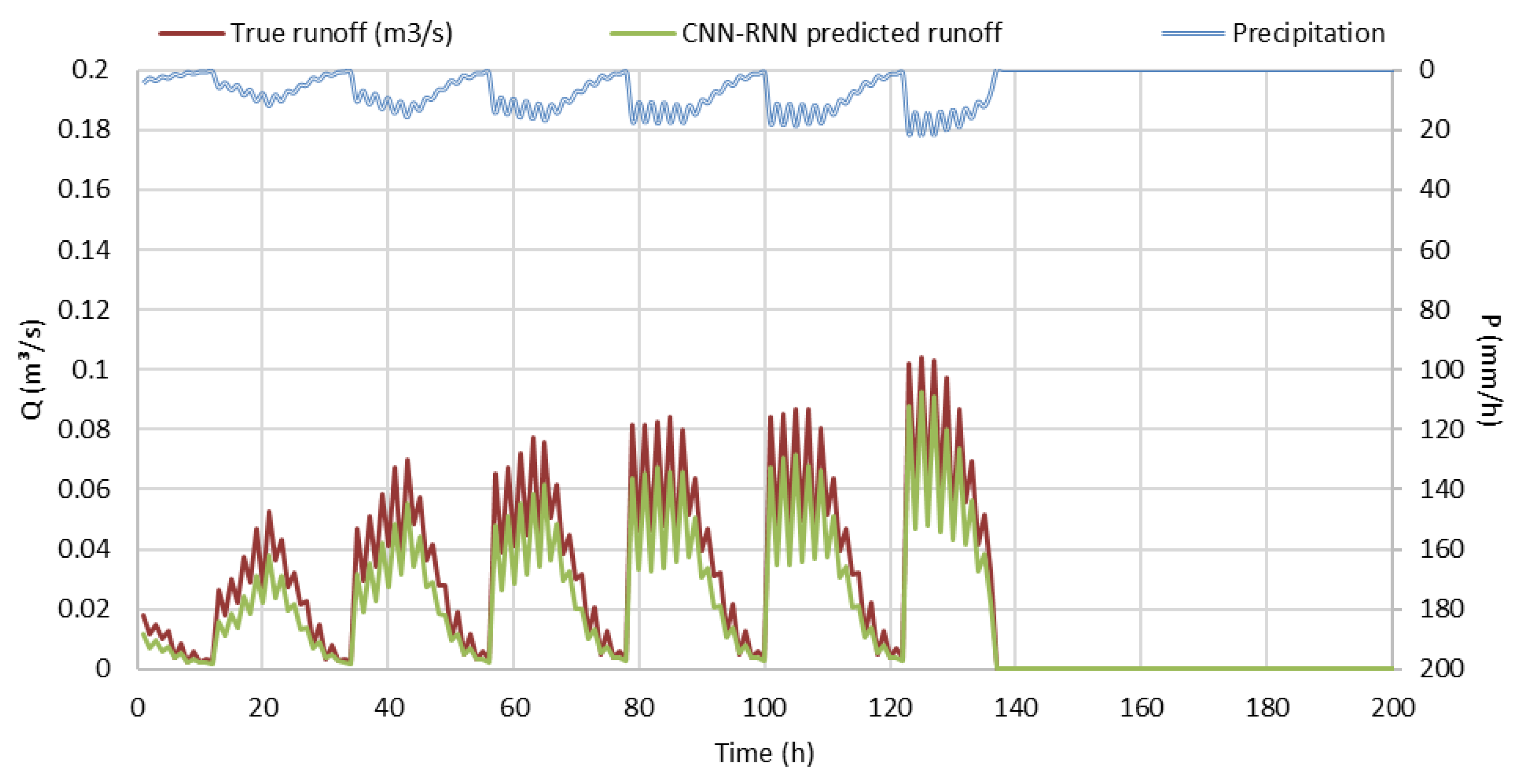
The performance of the CNN-RNN model, as illustrated in
Figure 4, demonstrates its effectiveness in runoff prediction. The alignment between observed and predicted runoff curves highlights the model’s high predictive accuracy. The model achieved a coefficient of determination (R
2) of 0.96, indicating that 96% of the variance in observed runoff data can be explained by the model’s predictions. This result confirms the robustness and reliability of the CNN-RNN approach for hydrological forecasting, highlighting its potential for improving flash-flood prediction and water resource management in arid regions.
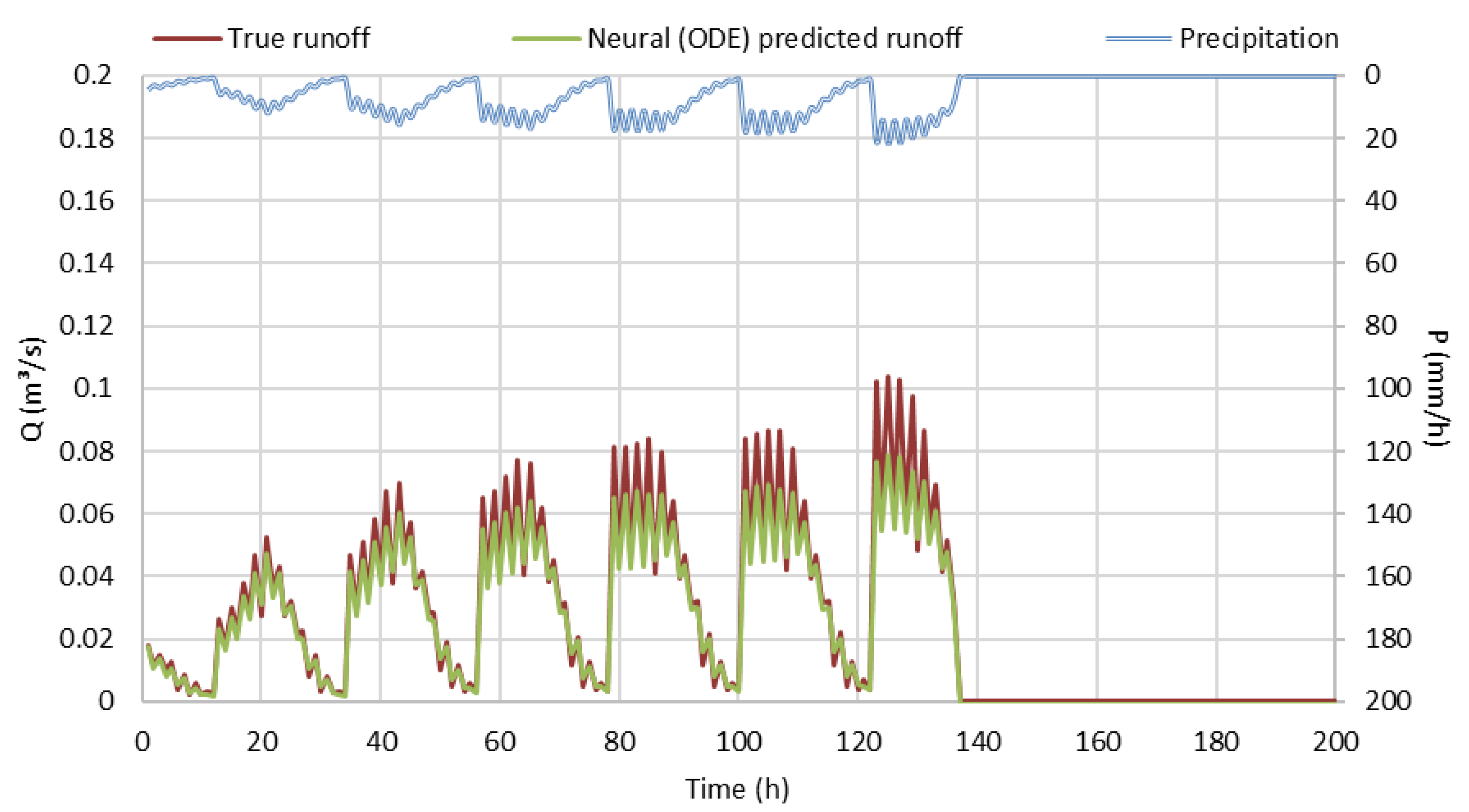
3.2. Modeling Using Neural ODE
Neural Ordinary Differential Equations (Neural ODEs) provide an innovative approach to incorporating continuous-time dynamics within neural network models, making them particularly effective for capturing the complex interactions in hydrological processes. Unlike traditional neural networks that function in discrete time steps, Neural ODEs model the continuous evolution of hidden states by parameterizing differential equations using neural networks. This approach enables the model to learn and represent the underlying continuous-time dynamics of runoff processes based on precipitation inputs.
The modeling framework begins by inputting precipitation data into an ODE block, which simulates the continuous evolution of runoff dynamics over time. The ODE block comprises neural network layers that define and parameterize the governing differential equations, allowing the model to capture the inherent temporal dependencies and hydrological variations in runoff generation. Once the ODE block processes the data, a fully connected layer transforms the output into the final runoff predictions, ensuring an accurate representation of the modeled hydrological response.
The predictive performance of the Neural ODE model is depicted in
Figure 5, which compares observed and predicted runoff values for the analyzed flood event. The model achieved an R
2 of 0.97, indicating that 97% of the variance in observed runoff data is effectively explained by the model’s predictions. This high accuracy underscores the effectiveness of Neural ODEs in capturing the complex, continuous-time hydrological dynamics, making them a valuable tool for advanced runoff modeling and flood forecasting applications.
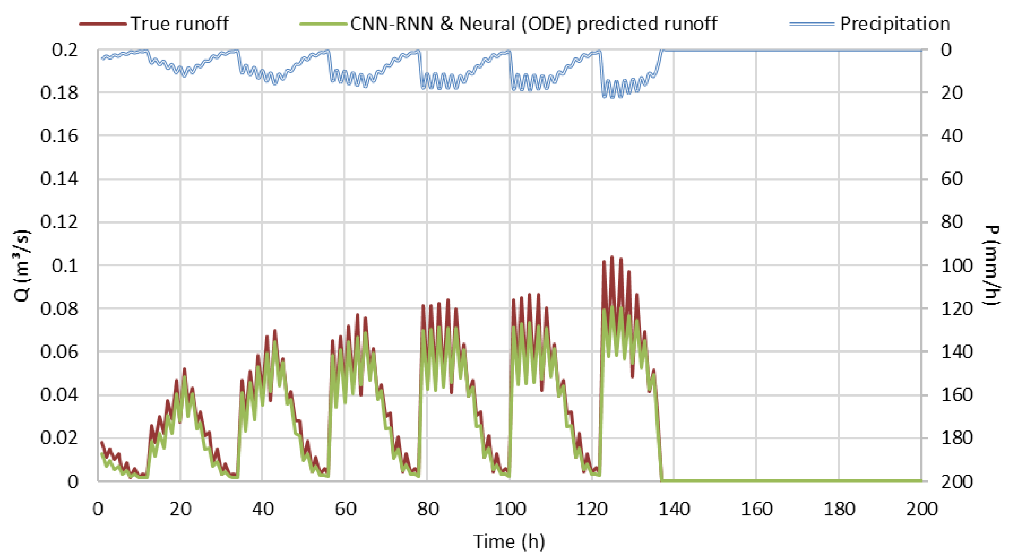
3.3. Modeling Using Integrated CNN-RNN with Neural ODE
This hybrid approach, which integrates CNN-RNN with Neural ODE, effectively combines the strengths of each individual model, resulting in enhanced predictive performance for runoff modeling based on precipitation data. The convolutional layers extract spatial features from the precipitation data, capturing localized patterns and key hydrological characteristics. The recurrent layers, specifically Long Short-Term Memory (LSTM) networks, capture temporal dependencies within the precipitation data, allowing the model to effectively represent sequence dynamics over time. The Neural ODE block models the continuous-time dynamics of the runoff process, offering a flexible and precise representation of the underlying physical hydrological phenomena. Finally, a fully connected layer transforms the output from the ODE block into the final runoff predictions, ensuring a comprehensive and accurate model output. The integrated model was assessed to ensure all components participate non-redundantly. Output fusion was executed after normalization to prevent over-amplification. Validation confirms no false doubling happened.
The performance of the integrated model is illustrated in
Figure 6, which compares the observed and predicted runoff values for the analyzed flood event. The integrated CNN-RNN-Neural ODE model achieved the highest predictive accuracy among all tested models, with an R
2 of 0.98, indicating that 98% of the variance in observed runoff data is effectively explained by the model’s predictions. The high Nash–Sutcliffe efficiency (NSE) value further confirms the model’s reliability in capturing both spatial and temporal dynamics of the runoff process. Additionally, the RMSE and MAE values highlight minimal prediction errors, demonstrating the robustness of the model. The low PBAIS value suggests that the model’s predictions exhibit minimal bias and closely align with observed runoff data. These results underscore the effectiveness of the integrated CNN-RNN-Neural ODE model in accurately simulating runoff dynamics, making it a valuable tool for hydrological modeling and flood forecasting applications.
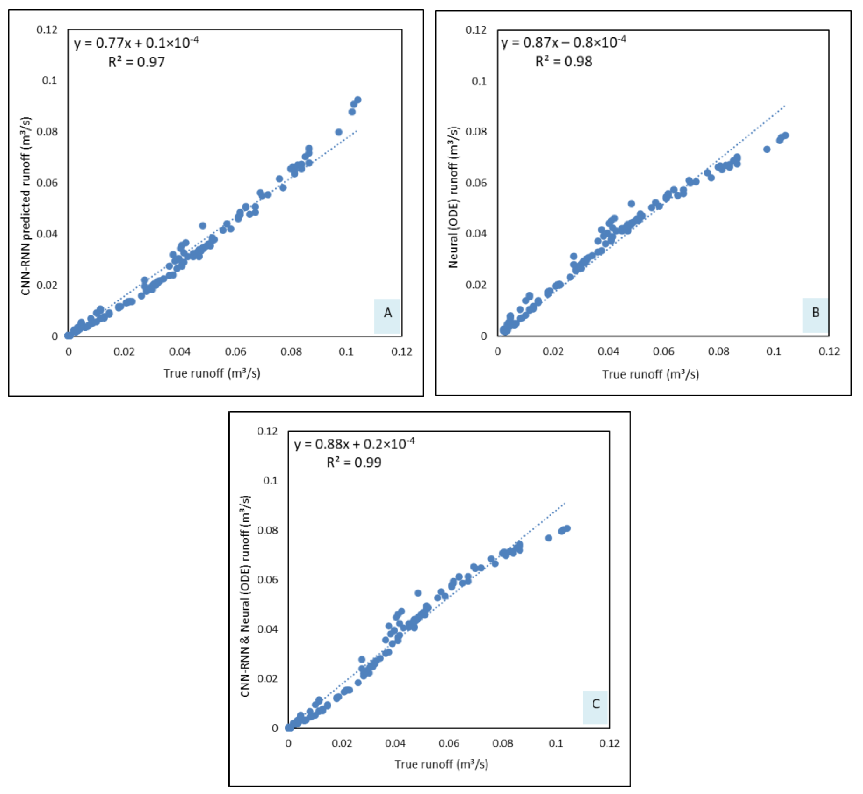
3.4. Comparisons of Developed Models
Shekar et al. [
18] employed six deep learning models, including Artificial Neural Networks (ANNs), K-Nearest Neighbors (KNN), Random Forest, Extreme Gradient Boosting (XGBoost), CNN, and CNN-RNN, to predict runoff based on training data. Among these, the CNN-RNN model outperformed all other models, achieving a testing accuracy of 0.97. Similarly, Adnan et al. [
43] conducted a comparative analysis of four machine learning models—Optimally Pruned Extreme Learning Machine (OPELM), Multivariate Adaptive Regression Splines (MARS), M5Tree, and MARS-Kmean—against a conceptual hydrological model, EBA4SUB. Their findings indicated that all machine learning models exhibited strong correlations with observed runoff values, with MARS-Kmean outperforming other models for long-term predictions. However, their approach required extensive datasets collected over long time periods, posing a significant data acquisition challenge.
In this study, the focus is shifted towards leveraging the capacity of deep learning models to learn complex, nonlinear relationships within hydrological data while simultaneously enhancing the accuracy of runoff prediction. The proposed CNN-RNN Neural ODE model demonstrated the highest predictive performance during training and testing phases, achieving an R2 value of 0.98, which indicates that 98% of the variance in the observed runoff data was effectively explained by the model. This represents a substantial improvement over the CNN-RNN and Neural ODE models, which achieved R2 values of 0.96 and 0.97, respectively. The superior R2 value of the integrated model underscores its enhanced ability to capture intricate hydrological patterns and improve runoff forecasting accuracy.
The comparative performance of the models is depicted in
Figure 7, where the integrated CNN-RNN with the Neural ODE model outperformed the other two models, further validating its effectiveness in predicting runoff dynamics. These findings highlight the advantages of integrating CNN, RNN, and Neural ODE for hydrological applications, demonstrating the model’s robustness in learning both spatial and temporal dependencies, and its potential for improving flood risk assessment and water resource management strategies.
In terms of Nash–Sutcliffe efficiency (NSE), the CNN-RNN Neural ODE model outperformed the other models, achieving a value of 0.98, indicating its high predictive accuracy and strong agreement with observed runoff data. While the Neural ODE and CNN-RNN models also demonstrated strong performance, their NSE values of 0.97 and 0.96, respectively, were slightly lower, reinforcing the superior predictive capabilities of the integrated approach.
The RMSE and MAE metrics further confirm the enhanced performance of the CNN-RNN Neural ODE model. It recorded the lowest RMSE of 2.87 × 10⁶ and MAE of 1.13 × 10⁶, reflecting minimal prediction errors. In contrast, the Neural ODE model had RMSE and MAE values of 3.41 × 10⁶ and 1.85 × 10⁶, respectively, while the CNN-RNN model showed values of 3.74 × 10⁶ and 1.66 × 10⁶, indicating relatively higher prediction errors compared to the integrated model.
The PBIAS values provide insights into the model’s bias and predictive balance. The CNN-RNN-Neural ODE model had a PBIAS of −8.38, indicating a slight underestimation but remaining within an acceptable range. This represents a significant improvement compared to the Neural ODE model (−25.48) and the CNN-RNN model (−13.73), demonstrating that the integrated model provides a more balanced and unbiased prediction.
CNN-RNNs with the usage of Long Short-Term Memory (LSTM) networks are mainly useful for sequential rainfall data in learning long-term temporal dependencies, which is a necessity for runoff pattern predictions. Despite this, it shows limitations in modeling rapid, nonlinear hydrological changes, owing to their discrete-time nature. On the contrary, Neural ODEs offered a continuous time framework, which enabled the capture of dynamic changes efficiently; nevertheless, they lacked the spatial resolution required to model catchment-scale variability successfully.
To eradicate these separate flaws, the integrated CNN-RNN with Neural ODEs in a hybrid framework is executed in this study. This integration allowed the model to hold LSTM’s strength in learning temporal sequences while aiding from Neural ODE’s continuous dynamics, thereby adjusting both spatial alertness and temporal understanding for flash-flood prediction.
Overall, the CNN-RNN-Neural ODE model demonstrated superior performance across all evaluation metrics, making it the most effective model for runoff prediction in this study. The integration of the CNN for spatial feature extraction, RNN (LSTM) for capturing temporal dependencies, and Neural ODE for modeling continuous-time dynamics effectively leverages the strengths of each approach. This results in higher predictive accuracy, reduced bias, and improved generalizability. Even though the model proved high accuracy during the April 2024 flood, future validation across multiple hydrological years is suggested to evaluate long-term predictive functioning. These findings underline the potential of integrated deep learning models in handling complex time-series prediction tasks, particularly in hydrological modeling and runoff forecasting.
4. Conclusions
The ability to accurately model runoff from precipitation data is critical for effective flood prediction and water resource management. Unlike conceptual models, machine learning and deep learning models leverage historical data trends to learn complex relationships and predict runoff values with high accuracy. In this study, three deep learning frameworks—CNN-RNN, Neural ODE, and the integrated CNN-RNN with Neural ODE—were developed and compared for predicting a recent flash-flood event in the Al Ain watershed, UAE. A dataset spanning six years (2016–2022) was used for training, while April 2024 data were utilized for testing.
Although all three models demonstrated strong predictive performance, the newly proposed integrated CNN-RNN with Neural ODE model significantly outperformed the other models in terms of accuracy and bias reduction. The models were evaluated using five key performance metrics: R
2 Nash–Sutcliffe efficiency (NSE), RMSE, MAE, and PBAIS. The integrated CNN-RNN with Neural ODE achieved the highest accuracy, with an R
2 = 0.98 and PBIAS = −8.38, indicating minimal bias and a strong correlation with observed runoff values. These findings support previous studies [
18,
38], which demonstrated the effectiveness of CNN-RNN and hybrid models in runoff prediction, and Mohammadi [
20] and Herath et al. [
19], which highlighted the role of machine learning in hydrological modeling.
The proposed framework has not been previously applied in hydrological studies and demonstrates efficiency in capturing the complex nature of precipitation-runoff relationships, highlighting its potential for advancing flood forecasting techniques. Given the increasing frequency and intensity of flash floods, such studies are essential for enhancing predictive capabilities, mitigating disaster impacts, and improving decision-making in flood risk management. Flash floods pose significant threats to human life, infrastructure, and economic stability, highlighting the necessity of developing robust, data-driven forecasting models to enhance preparedness, resilience, and adaptive water resource management strategies.
Future research should focus on enhancing the model’s applicability by integrating high-resolution remote sensing data, real-time hydrometeorological observations, and ensemble learning techniques to improve accuracy and scalability. Furthermore, incorporating explainable AI (XAI) methodologies can enhance model interpretability, facilitating more informed decision-making in flood risk management. Moreover, expanding the study to different geographic regions and validating the model across diverse hydrological landscapes will further assess its robustness and adaptability. Addressing these research directions will contribute to the advancement of flood forecasting methodologies.


