
Mechanisms Controlling Multiphase Landslide Reactivation at Red Soil–Sandstone Interfaces in Subtropical Climates: A Case Study from the Eastern Pearl River Estuary


Abstract
1. Introduction
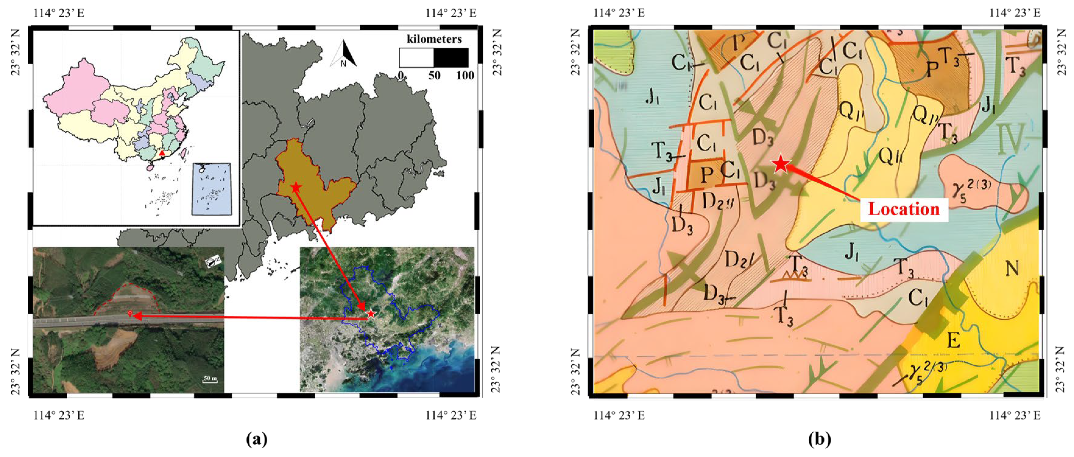
2. Study Location
3. Methodology
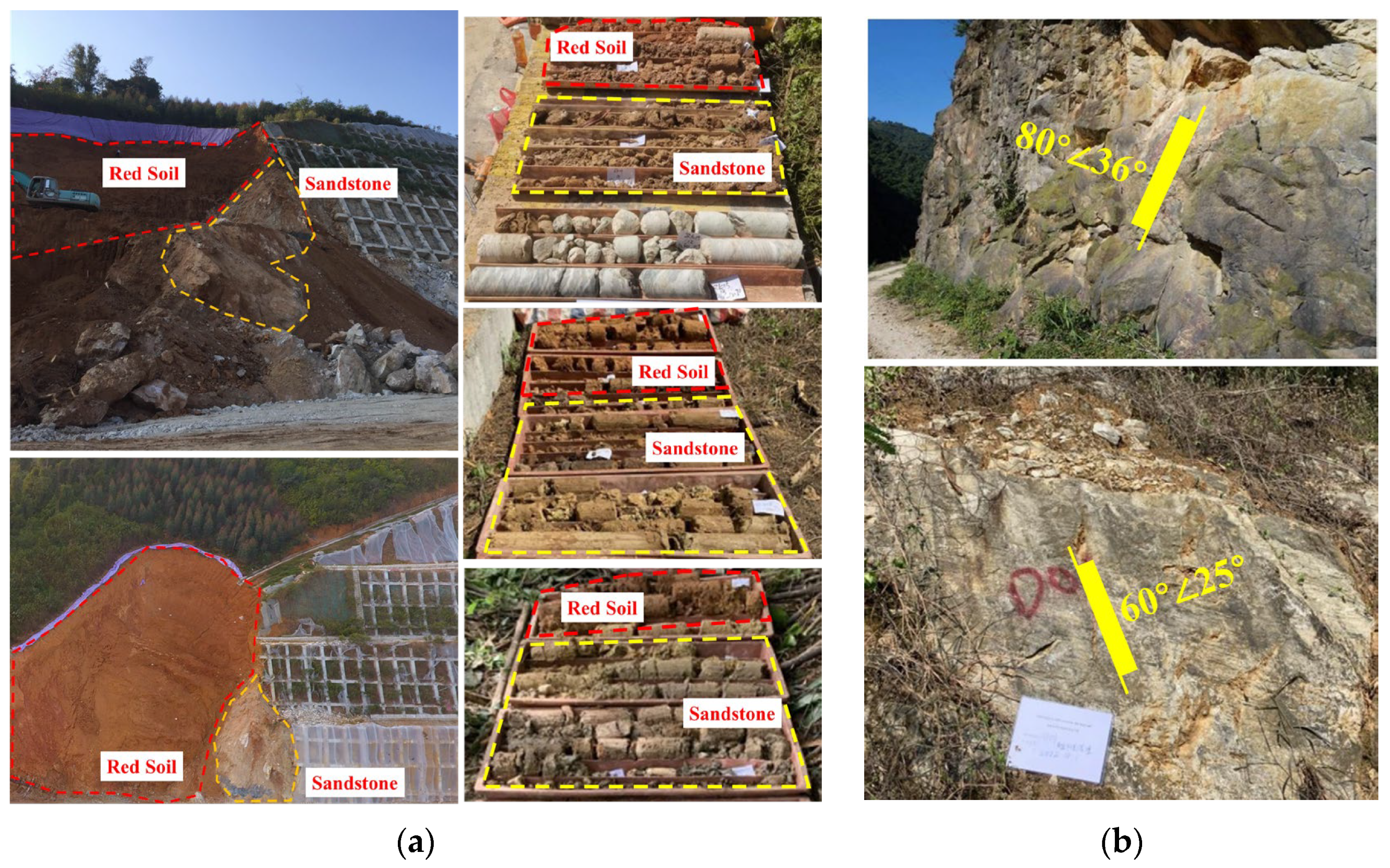
3.1. Field and Laboratory Investigations
3.2. Methodology of Random Forest Model
- (1)
- Data collection and organization. Landslide and rainfall data are collected, and the collected data are cleaned to remove abnormal values, missing values, etc., to ensure the accuracy and reliability of the data. The rainfall data and landslide data are organized in chronological order to facilitate subsequent analysis.
- (2)
- Feature extraction. Extract the characteristic parameters that may be related to the occurrence of landslides, such as daily rainfall, cumulative rainfall, etc., from the rainfall data.
- (3)
- Model building. Input independent variables, including at different time scales, such as daily rainfall, cumulative rainfall in the previous period, and so on. The output-dependent variable, the probability of landslide occurrence, is the main result of the model output, indicating the possibility of landslide occurrence under the given rainfall conditions. A random forest algorithm is chosen to establish the relationship between inputs and outputs. The collected historical rainfall data and landslide data were used to train and validate the model.
- (4)
- Model Validation. The five-fold cross-validation of the model was performed using multiple independent datasets (data cut-off 9:1) to assess its predictive and generalization abilities. Based on the validation results, the multiset model was optimized and adjusted to improve its accuracy and usefulness.
- (5)
- Determination of rainfall thresholds. The interval of the cumulative rainfall in the previous period under the probability of rainfall occurrence obtained from the training results of multiple models is used as the rainfall threshold for landslide occurrence.
4. Results and Discussion
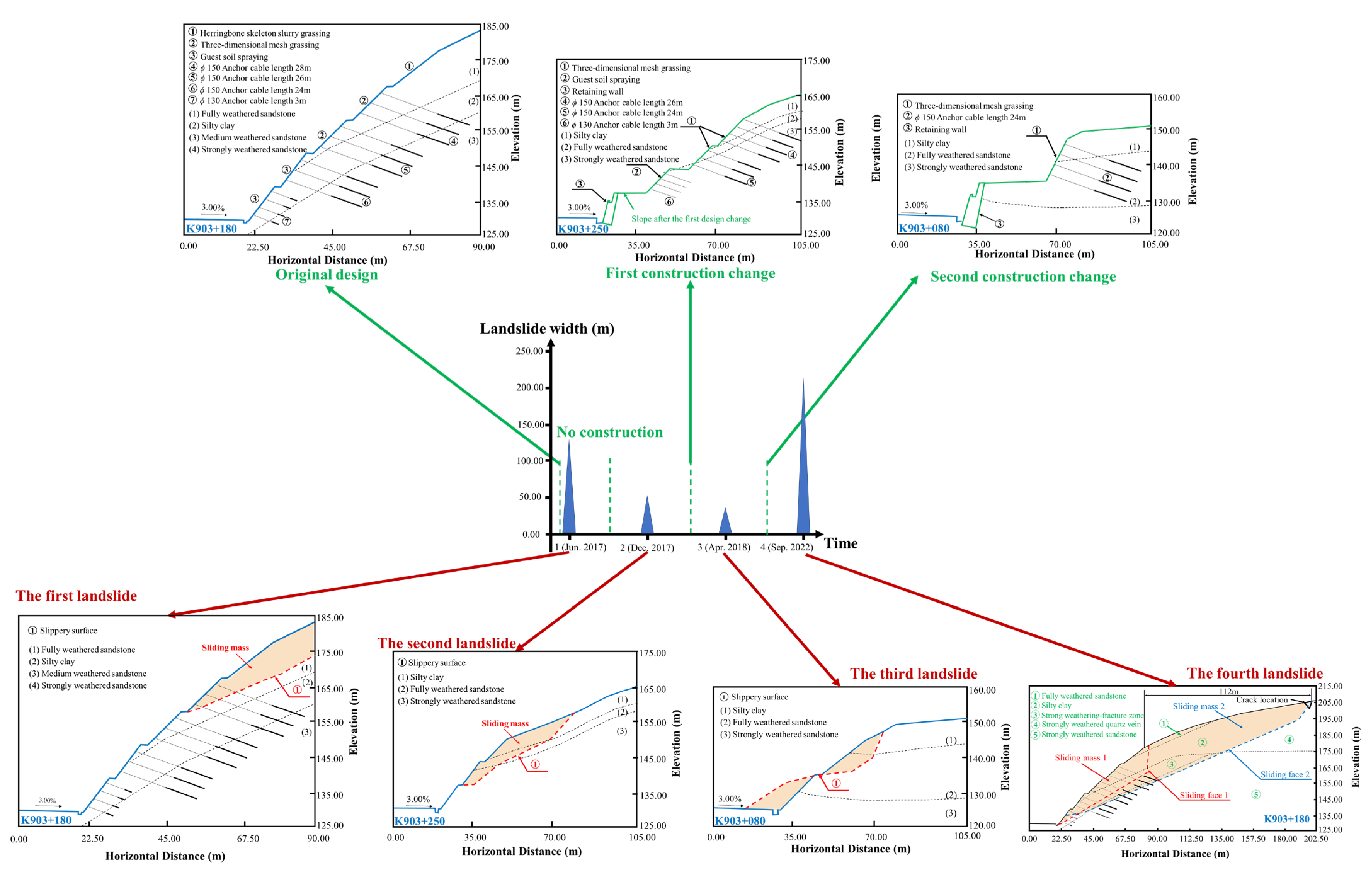
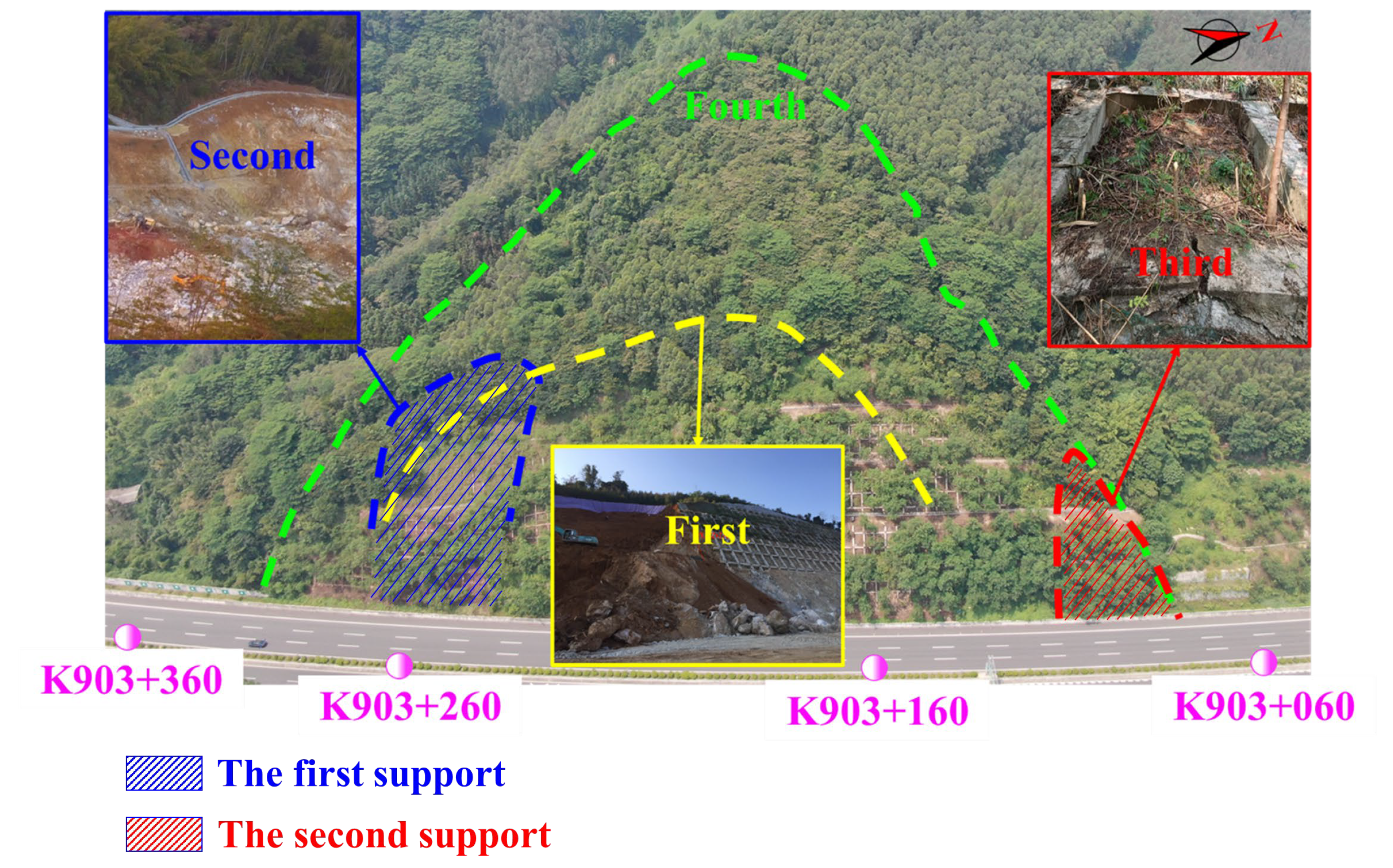
4.1. Evolutionary History of Multi-Stage Revival of Landslides
- (1)
- Characterization of the first landslide
- (2)
- Characterization of the second landslide and the first construction change
- (3)
- Characterization of the third landslide and second construction changes
- (4)
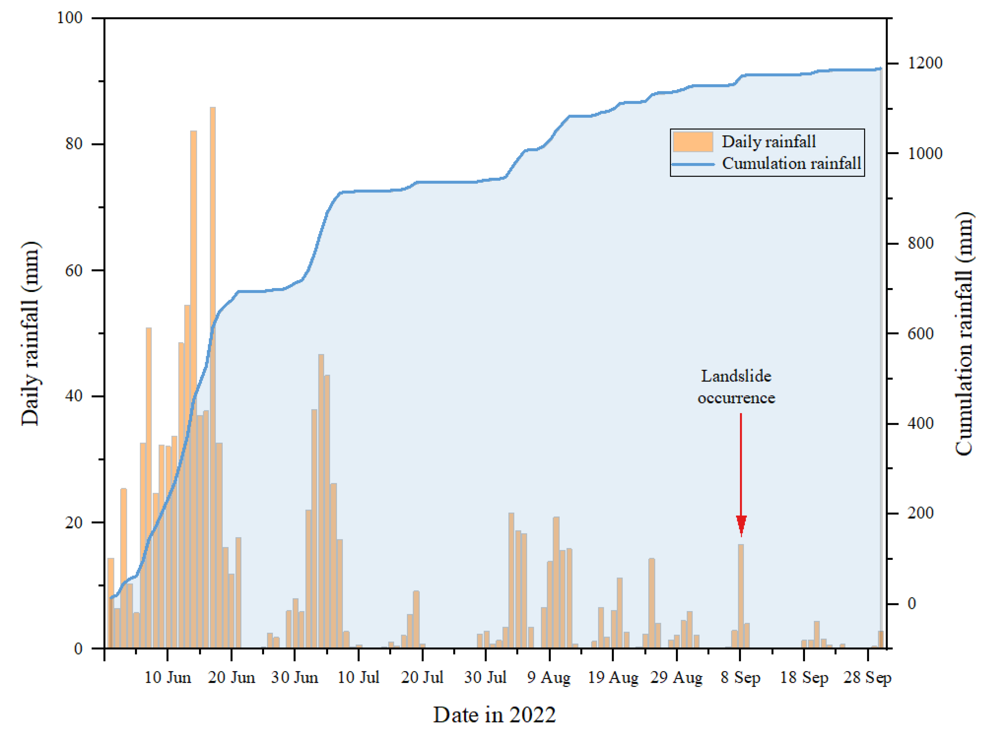
- Characterization of the fourth landslide and its relationship with rainfall
4.2. Random Forest Model Outcomes
4.3. The Role of the Red Soil–Sandstone Interface in Influencing Successive Landslides
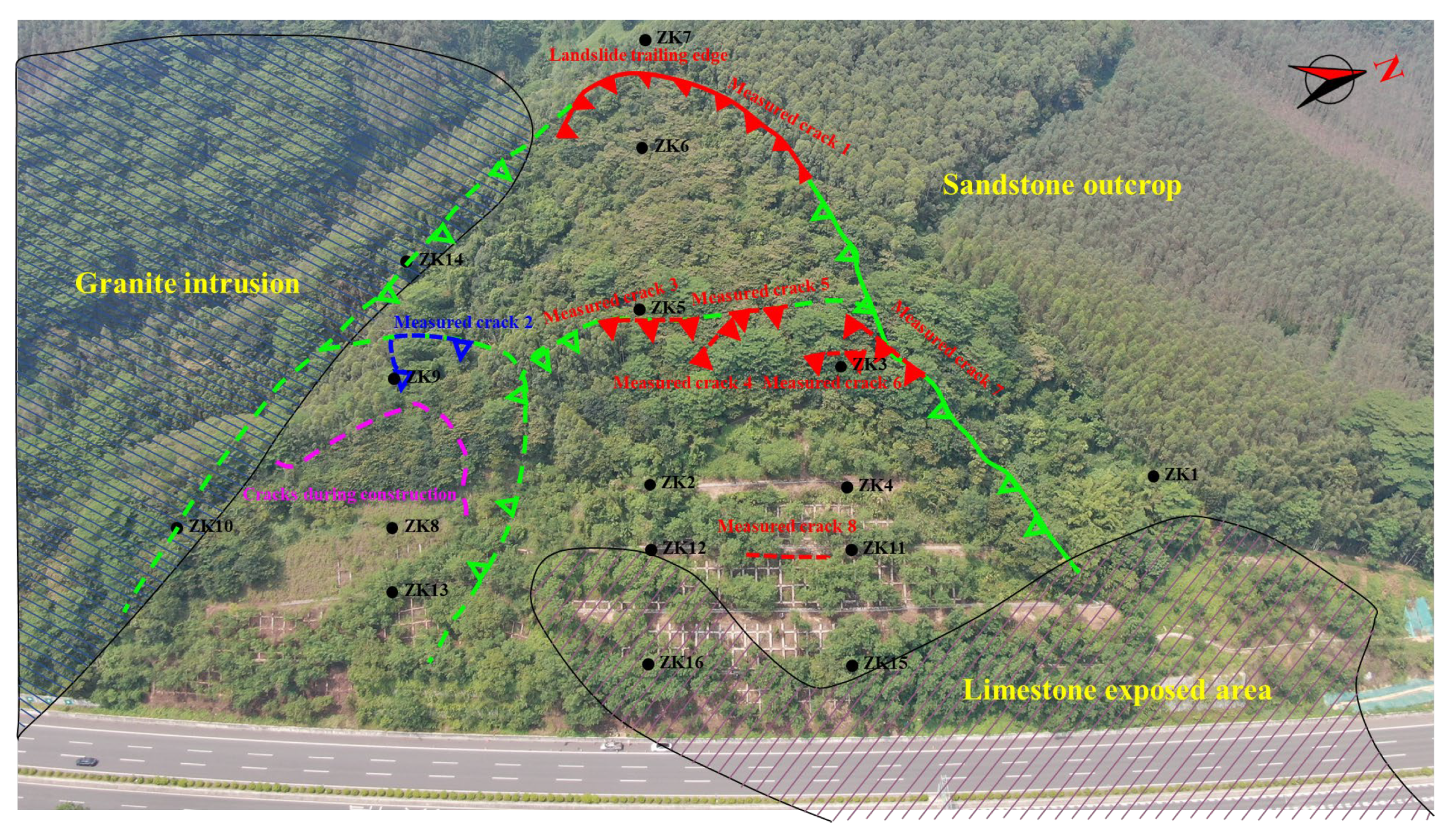
4.3.1. Landslide Perimeter Determination
4.3.2. Sliding Surface Determination
4.3.3. Interaction and Traction Relationship Between Landslide #1 and Landslide #2
4.4. Mechanisms of Landslide Genesis at the Red Soil–Sandstone Interface
4.4.1. Mechanical Properties of Red Soil and Sandstone
4.4.2. Characteristics of the Red Soil–Sandstone Interface
4.4.3. Landslide Causes Analysis
- (1)
- Endogenous causes
- ①
- Stratigraphic lithology
- ②
- Geomorphological Vulnerability
- (2)
- External causes
- ①
- Rainfall
- ②
- Groundwater dynamics
- ③
- Human interventions
- (3)
- Multi-Factor Coupling Mechanism
- ①
- Hydro-Mechanical Feedback
- ②
- Anthropogenic-Geological Interaction
- ③
- Temporal-Spatial Coupling
- ④
- Progressive Failure Sequence
4.4.4. Landslide Mechanism
5. Summary and Conclusions
- (1)
- Through an in-depth analysis of the 2022 landslide event at the laterite–sandstone interface along the east coast of the Pearl River Estuary, this study reveals the interaction mechanism between landslide occurrence and complex geological conditions, intense rainfall, and human engineering activities. Our results show that the resurrection and evolution of landslides are the result of multistage and multi-factors, especially rainfall as an external trigger, which significantly reduces the physical strength of the soil through infiltration, leading to the occurrence and expansion of landslides. This provides an important reference for us to further understand the complex dynamic process of landslides.
- (2)
- In this study, the relationship between landslide size and rainfall was explored in detail using field survey, UAV photogrammetry, and geologic analysis. Our results show a significant positive correlation between the size of landslides and cumulative rainfall, which further validates the key role of rainfall in landslide occurrence and expansion. This finding is of great practical significance for the prediction, assessment, and prevention of landslide disasters in the future.
- (3)
- This study significantly enhances our understanding of the evolution, destabilization process, and risk mitigation strategies of multiphase laterite–sandstone interface landslide revival along the east coast of the Pearl River Estuary. Despite the in-depth exploration of the causes, mechanisms, and impacts of the event, the relatively short time scales of the data may not be sufficient to fully reflect the impacts of long-term geologic processes and climate change on landslide activities. Future studies should consider introducing monitoring data with longer time scales to more fully assess the dynamic processes of landslides.
- (4)
- The results of this study can be directly applied to landslide risk assessment and mitigation in similar regions, particularly in subtropical climates with red soil–sandstone interfaces. The proposed mitigation strategies, including improved drainage systems and slope reinforcement, can significantly reduce landslide risks. Future research should focus on long-term monitoring of landslide-prone areas to better understand the impacts of climate change and anthropogenic activities on slope stability. Additionally, advanced numerical modeling techniques can be employed to simulate landslide dynamics under different scenarios.
Author Contributions
Funding
Data Availability Statement
Acknowledgments
Conflicts of Interest
References
- Qizhi, M.; Ying, L.; Yang, W. Spatio-Temporal Changes of Population Density and Exploration on Urbanization Pattern in China: 2000–2010. City Plan. Rev. 2015, 39, 38–43. (In Chinese) [Google Scholar]
- Deng, Z.; Lan, H.; Li, L.; Sun, W. Vegetation-induced modifications in hydrological processes and the consequential dynamic effects of slope stability. CATENA 2025, 251, 108793. [Google Scholar] [CrossRef]
- Liu, C.; Bao, H.; Lan, H.; Yan, C.; Li, C.; Liu, S. Failure evaluation and control factor analysis of slope block instability along traffic corridor in Southeastern Tibet. J. Mt. Sci. 2024, 21, 1830–1848. [Google Scholar] [CrossRef]
- Wang, Y.; Gao, G.; Zhai, J.; Liu, Q.; Song, L. Evolution characteristics of the rainstorm disaster chains in the Guangdong–Hong Kong–Macao Greater Bay Area, China. Nat. Hazards 2023, 119, 2011–2032. [Google Scholar] [CrossRef]
- Zhu, C.; Cheng, S.; Li, Q.; Shan, H.; Lu, J.A.; Shen, Z.; Liu, X.; Jia, Y.J. Giant submarine landslide in the South China Sea: Evidence, causes, and implications. J. Mar. Sci. Eng. 2019, 7, 152. [Google Scholar] [CrossRef]
- Felix-Henningsen, P.; Liang-Wu, L.; Zakosek, H. Distribution and genesis of red and yellow soils in the central subtropics of southeast China. CATENA 1989, 16, 73–89. [Google Scholar] [CrossRef]
- Sun, L.; Li, C.; Shen, F.; Zhang, H. Reactivation mechanism and evolution characteristics of water softening-induced reservoir-reactivated landslides: A case study for the Three Gorges Reservoir Area, China. Bull. Eng. Geol. Environ. 2023, 82, 66. [Google Scholar] [CrossRef]
- Harrison, P.J.; Yin, K.; Lee, J.H.W.; Gan, J.; Liu, H. Physical–biological coupling in the Pearl River Estuary. Cont. Shelf Res. 2008, 28, 1405–1415. [Google Scholar] [CrossRef]
- Kaczmarek, H.; Tyszkowski, S.; Banach, M. Landslide development at the shores of a dam reservoir (Włocławek, Poland), based on 40 years of research. Environ. Earth Sci. 2015, 74, 4247–4259. [Google Scholar] [CrossRef]
- Vadivel, S.; Sennimalai, C.S. Failure Mechanism of Long-Runout Landslide Triggered by Heavy Rainfall in Achanakkal, Nilgiris, India. J. Geotech. Geoenvironmental Eng. 2019, 145, 04019047. [Google Scholar] [CrossRef]
- Dai, Z.W.; Yang, L.; Zhang, N.; Zhang, C.Y.; Zhang, Z.H.; Wang, H. Deformation characteristics and reactivation mechanism of an old landslide induced by combined action of excavation and heavy rainfall. Front. Earth Sci. 2023, 10, 1009855. [Google Scholar] [CrossRef]
- Cruden, D.M.; Varnes, D.J. Landslide types and processes, special report, transportation research board. Proc. Natl. Acad. Sci. USA 1996, 247, 36–75. [Google Scholar]
- Fan, X.; Scaringi, G.; Xu, Q.; Zhan, W.; Dai, L.; Li, Y.; Pei, X.; Yang, Q.; Huang, R. Coseismic landslides triggered by the 8th August 2017 Ms 7.0 Jiuzhaigou earthquake (Sichuan, China): Factors controlling their spatial distribution and implications for the seismogenic blind fault identification. Landslides 2018, 15, 967–983. [Google Scholar] [CrossRef]
- Li, C.; Fu, Z.; Wang, Y.; Tang, H.; Yan, J.; Gong, W.; Yao, W.; Criss, R.E. Susceptibility of reservoir-induced landslides and strategies for increasing the slope stability in the Three Gorges Reservoir Area: Zigui Basin as an example. Eng. Geol. 2019, 261, 105279. [Google Scholar] [CrossRef]
- Stark, T.D.; Baghdady, A.K.; Hungr, O.; Aaron, J. Case Study: Oso, Washington, Landslide of March 22, 2014—Material Properties and Failure Mechanism. J. Geotech. Geoenviron. Eng. 2017, 143, 05017001. [Google Scholar] [CrossRef]
- Wouatong, A.; Yerima, B.; Fouateu, R.Y.; Ze, A.M.; Ekodeck, G. The origin of etch pits recorded on residual grain surfaces from kaolinized granitic rocks west region Cameroon. Earth Sci. Res. 2013, 2, 93. [Google Scholar] [CrossRef]
- Lai, C.G.; Chen, X.H.; Wang, Z.L.; Xu, C.Y.; Yang, B. Rainfall-induced landslide susceptibility assessment using random forest weight at basin scale. Hydrol. Res. 2018, 49, 1363–1378. [Google Scholar] [CrossRef]
- Yang, S.; Tan, Z.; Chen, H.; Zhang, J. Analysis of instability disaster of rainfall induced shallow landslides at the regional scale based on the modified Green Ampt model. Bull. Geol. Sci. Technol. 2022, 41, 219–227. [Google Scholar] [CrossRef]
- Xuan, P.; Pho, N.; Gas’kova, O.; Bortnikova, S. Geochemistry of surface waters in the vicinity of open pit mines at the Cay Cham deposit, Thai Nguyen province, northern Vietnam. Geochem. Int. 2013, 51, 931–938. [Google Scholar] [CrossRef]
- McSaveney, M.; Griffiths, G.A. Drought, rain, and movement of a recurrent earthflow complex in New Zealand. Geology 1987, 15, 643–646. [Google Scholar] [CrossRef]
- Zhang, J.M.; Zhou, Z.; Lin, F.; Yang, Q.G.; Luo, Y. Failure mechanism of a slow-moving landslide on September 27, 2020, in Chang Nong Village, Guangxi, China. Landslides 2021, 18, 2575–2592. [Google Scholar] [CrossRef]
- Wang, R.; Zhang, K.; Ning, Y.; Xu, W.; Wang, W.; Qin, J. Reactivation of Ancient Landslide Deposits: Geological Characteristics and Deformation Mechanism. Adv. Civ. Eng. 2021, 2021, 6614180. [Google Scholar] [CrossRef]
- Zhou, C.Y.; Cui, G.J.; Yin, H.; Yu, L.; Xu, G.K.; Liu, Z.; Zhang, L.H. Study of soil expansion characteristics in rainfall-induced red-bed shallow landslides: Microscopic and macroscopic perspectives. PLoS ONE 2021, 16, e0246214. [Google Scholar] [CrossRef] [PubMed]
- Su, X.X.; Tang, H.M.; Huang, L.; Shen, P.W.; Xia, D. The role of pH in red-stratum mudstone disintegration in the Three Gorges reservoir area, China, and the associated micromechanisms. Eng. Geol. 2020, 279, 105873. [Google Scholar] [CrossRef]
- Wang, B. Failure mechanism of an ancient sensitive clay landslide in eastern Canada. Landslides 2019, 16, 1483–1495. [Google Scholar] [CrossRef]
- Paronuzzi, P.; Bolla, A.; Pinto, D.; Lenaz, D.; Soccal, M. The clays involved in the 1963 Vajont landslide: Genesis and geomechanical implications. Eng. Geol. 2021, 294, 106376. [Google Scholar] [CrossRef]
- Conte, E.; Donato, A.; Troncone, A. A simplified method for predicting rainfall-induced mobility of active landslides. Landslides 2017, 14, 35–45. [Google Scholar] [CrossRef]
- Tang, H.; Yong, R.; Ez Eldin, M.A.M. Stability analysis of stratified rock slopes with spatially variable strength parameters: The case of Qianjiangping landslide. Bull. Eng. Geol. Environ. 2017, 76, 839–853. [Google Scholar] [CrossRef]
- Zhang, G.; Cai, Y.; Zheng, Z.; Zhen, J.; Liu, Y.; Huang, K. Integration of the Statistical Index Method and the Analytic Hierarchy Process technique for the assessment of landslide susceptibility in Huizhou, China. CATENA 2016, 142, 233–244. [Google Scholar] [CrossRef]
- Rong, G.; Alu, S.; Li, K.; Su, Y.; Zhang, J.; Zhang, Y.; Li, T. Rainfall Induced Landslide Susceptibility Mapping Based on Bayesian Optimized Random Forest and Gradient Boosting Decision Tree Models—A Case Study of Shuicheng County, China. Water 2020, 12, 3066. [Google Scholar] [CrossRef]
- Wang, P.; Bai, X.; Wu, X.; Yu, H.; Hao, Y.; Hu, B.X. GIS-Based Random Forest Weight for Rainfall-Induced Landslide Susceptibility Assessment at a Humid Region in Southern China. Water 2018, 10, 1019. [Google Scholar] [CrossRef]
- Dou, J.; Yunus, A.P.; Bui, D.T.; Merghadi, A.; Sahana, M.; Zhu, Z.F.; Chen, C.W.; Khosravi, K.; Yang, Y.; Pham, B.T. Assessment of advanced random forest and decision tree algorithms for modeling rainfall-induced landslide susceptibility in the Izu-Oshima Volcanic Island, Japan. Sci. Total Environ. 2019, 662, 332–346. [Google Scholar] [CrossRef]
- Cao, G.; Scanlon, B.R.; Han, D.; Zheng, C. Impacts of thickening unsaturated zone on groundwater recharge in the North China Plain. J. Hydrol. 2016, 537, 260–270. [Google Scholar] [CrossRef]
- Tian, S.F.; Hu, G.S.; Chen, N.S.; Rahman, M.; Ni, H.Y.; Somos-Valenzuela, M. Effects of Tectonic Setting and Hydraulic Properties on Silent Large-Scale Landslides: A Case Study of the Zhaobishan Landslide, China. Int. J. Disaster Risk Sci. 2023, 14, 600–617. [Google Scholar] [CrossRef]
- Canuti, P.; Focardi, P.; Garzonio, C. Correlation between rainfall and landslides. Bull. Eng. Geol. Environ. 1985, 32, 49–54. [Google Scholar] [CrossRef]
- Chen, C.-W.; Oguchi, T.; Hayakawa, Y.S.; Saito, H.; Chen, H. Relationship between landslide size and rainfall conditions in Taiwan. Landslides 2017, 14, 1235–1240. [Google Scholar] [CrossRef]
- Saito, H.; Korup, O.; Uchida, T.; Hayashi, S.; Oguchi, T. Rainfall conditions, typhoon frequency, and contemporary landslide erosion in Japan. Geology 2014, 42, 999–1002. [Google Scholar] [CrossRef]
- Zhang, M.; Wilson, M.J.; He, Z. Mineralogy of Red Soils in Southern China in Relation to Their Development and Charge Characteristics. In The Red Soils of China: Their Nature, Management and Utilization; Wilson, M.J., He, Z., Yang, X., Eds.; Springer: Dordrecht, The Netherlands, 2004; pp. 35–61. [Google Scholar]
- Fredlund, D.G.; Rahardjo, H. Soil Mechanics for Unsaturated Soils; John Wiley & Sons: Hoboken, NJ, USA, 1993. [Google Scholar]
- Zhang, L.; Fredlund, D.; Zhang, L.; Tang, W. Numerical study of soil conditions under which matric suction can be maintained. Can. Geotech. J. 2004, 41, 569–582. [Google Scholar] [CrossRef]


| Date (Month/Year) | Location | Main Characteristics | ||
|---|---|---|---|---|
| Crack Length (m) | Maximum Crack Width (m) | Maximum Slide Depth (m) | ||
| June 2017 | K903+150–K903+275 s stage slope | 40.00 | 0.20 | 1.50 |
| December 2017 | K903+240–K903+290 slope | The height of the staggered platform 17 m outside the top of the slope is approximately 5 m | ||
| April 2018 | K903+073–K903+103 first stage slope | The landslide is in the shape of a chair. There is a staggered platform 3 m outside the top of the slope. The first stage of the platform is subdued. | ||
| Test Name | Silty Clay Quick Shear | Silty Clay Consolidation Test | Fully Weathered Sandstone Quick Shear | Fully Weathered Sandstone Consolidation Test | ||||
|---|---|---|---|---|---|---|---|---|
| Items | c (kPa) | φ (°) | av (MPa−1) | Es (MPa) | c (kPa) | φ (°) | av (MPa−1) | Es (MPa) |
| Maximum | 24.3 | 22.1 | 0.950 | 8.34 | 23.9 | 17.5 | 0.740 | 4.12 |
| Minimum | 15.1 | 6.9 | 0.310 | 2.28 | 23.9 | 17.5 | 0.440 | 2.79 |
| Mean | 20.0 | 13.0 | 0.686 | 3.69 | 23.9 | 17.5 | 0.563 | 3.63 |
| Numbers | 13 | 13 | 13 | 13 | 1 | 1 | 3 | 3 |
Disclaimer/Publisher’s Note: The statements, opinions and data contained in all publications are solely those of the individual author(s) and contributor(s) and not of MDPI and/or the editor(s). MDPI and/or the editor(s) disclaim responsibility for any injury to people or property resulting from any ideas, methods, instructions or products referred to in the content. |
© 2025 by the authors. Licensee MDPI, Basel, Switzerland. This article is an open access article distributed under the terms and conditions of the Creative Commons Attribution (CC BY) license (https://creativecommons.org/licenses/by/4.0/).
Share and Cite
Zhang, Y.; Liao, J.; You, Y.; Li, Z.; Zhou, C.; Liu, Z. Mechanisms Controlling Multiphase Landslide Reactivation at Red Soil–Sandstone Interfaces in Subtropical Climates: A Case Study from the Eastern Pearl River Estuary. Water 2025, 17, 1139. https://doi.org/10.3390/w17081139
Zhang Y, Liao J, You Y, Li Z, Zhou C, Liu Z. Mechanisms Controlling Multiphase Landslide Reactivation at Red Soil–Sandstone Interfaces in Subtropical Climates: A Case Study from the Eastern Pearl River Estuary. Water. 2025; 17(8):1139. https://doi.org/10.3390/w17081139
Chicago/Turabian StyleZhang, Yongxiong, Jin Liao, Yongchun You, Zhibin Li, Cuiying Zhou, and Zhen Liu. 2025. "Mechanisms Controlling Multiphase Landslide Reactivation at Red Soil–Sandstone Interfaces in Subtropical Climates: A Case Study from the Eastern Pearl River Estuary" Water 17, no. 8: 1139. https://doi.org/10.3390/w17081139
APA StyleZhang, Y., Liao, J., You, Y., Li, Z., Zhou, C., & Liu, Z. (2025). Mechanisms Controlling Multiphase Landslide Reactivation at Red Soil–Sandstone Interfaces in Subtropical Climates: A Case Study from the Eastern Pearl River Estuary. Water, 17(8), 1139. https://doi.org/10.3390/w17081139