Article

Geographic Information System-Based Database for Monitoring and Assessing Mining Impacts on Water Resources and Environmental Systems at National Scale: A Case Study of Morocco (North Africa)

1
Resources Valorization, Environment and Sustainable Development Research Team (RVESD), Department of Mines, Mines School of Rabat, Ave Hadj Ahmed Cherkaoui, BP 753, Agdal, Rabat 10090, Morocco
2
Geology and Sustainable Mining Institute, Mohammed VI Polytechnic University, Benguerir 43150, Morocco
3
AGHYLE, Institut Polytechnique UniLaSalle Beauvais, 19 Rue Pierre Waguet, 60000 Beauvais, France
*
Authors to whom correspondence should be addressed.
Water 2025, 17(7), 924; https://doi.org/10.3390/w17070924
Submission received: 24 February 2025 / Revised: 9 March 2025 / Accepted: 12 March 2025 / Published: 22 March 2025
(This article belongs to the Special Issue Monitoring and Modelling of Contaminants in Water Environment)

Abstract

:
Decision-making in how to manage environmental issues around mine sites is generally a complicated task. Furthermore, the large amount of data and information involved in the management process is cumbersome. However, Decision Support Tools (DSTs) based on Geographic Information Systems (GISs) are of great interest to environmental managers in order to help them to make well-informed and thoroughly documented decisions regarding reclamation plans, especially for abandoned mine sites. The current study highlights the implementation of a cost-effective and efficient GIS-based database as a DST that will be used to assess and manage environmental challenges, particularly those related to water resources, such as hydrographic network issues surrounding mine sites. Based on GISs, a prototype of a national geodatabase was designed and implemented for Moroccan mine sites. It consisted of a set of GIS layers that facilitated the dissemination of an extensive array of multidisciplinary environmental data concerning Moroccan mines to decisionmakers. By applying GIS tools, such as buffer zone analysis, to environmental and hydrological datasets, high-priority mines requiring urgent intervention were identified based on their proximity to water resources, their acid mine drainage (AMD) potential, and their environmental impact on ecosystems. The results highlight the effectiveness of GIS-based approaches in assessing environmental risks, particularly concerning water resources, while also contributing to sustainable mining management in Morocco. Finally, using the GIS-based database is expected to raise the awareness of decisionmakers in government agencies and mining companies for implementing a reclamation program for mine sites.

1. Introduction

Mining industry is recognized as a considerable source of contamination by heavy metals and metalloids and a potential public health hazard [1,2]. Throughout the mining industry supply chain, overburden, waste rocks, tailings, and slags that may contain a wide range of heavy metals and metalloids are intensively generated and discharged in the surrounding environment [3]. Without proper management, abandoned mines could often cause more serious environmental impacts than active mines [1]. Therefore, many health hazards might be expected for the exposed population [4,5]. Over the past century, 150 mine sites have been closed, all of which remain abandoned without any implemented rehabilitation program [6,7]. The contained mine wastes may result in severe contamination of the surrounding environment, including the soils and water [7,8]. Therefore, concern about the adverse effect of mines has been raised in Morocco [9,10], and numerous research studies and investigations have been conducted [11]. Conventional environmental studies are useful and easy to use. However, they are also somewhat cumbersome and time-consuming in terms of compiling and interpreting the data derived from multiple sources, especially when expansive geographic areas are of concern [12,13,14]. Furthermore, the outcomes of these studies are usually reported in unpublished documents, which are unfortunately unavailable for environmental managers and decisionmakers [15,16]. Therefore, in order to ensure that any investment in environmental studies reaps maximum benefit in terms of efficient management of environmental issues at mine sites, it is crucial that these studies address difficulties related to the analysis, the interpretation and the sharing of geospatial data [17]. In this context, Geographic Information Systems (GISs), as computer-based systems, are powerful tools to overcome the limitation of traditional studies in handling and compiling geospatial data [18,19]. They have effectively addressed the existing challenges associated with the integration of numerous spatial parameters inherent to environmental studies [20,21]. Furthermore, GIS-based spatial analysis has found widespread application in solving of a large spectrum of complex spatially extended problems [10,22,23]. In the mining field, various studies have demonstrated that GISs have become a valuable tool [24,25]. They have provided an effective framework for collecting, geoprocessing, analyzing, and generating spatial and non-spatial data (attribute) [18,26,27], with great potential for the adequate monitoring of environmental issues around mine sites [28,29,30]. In particular, GISs have proven to be instrumental in assessing the impact of mining activities on water resources, enabling the identification of contamination risks, the mapping of groundwater vulnerability, and the spatial analysis of hydrological networks [31,32,33]. Takings inspiration from more pertinent environmental studies on mine sites, the current project aims to fill the gap in Morocco by conducting such research at national scale to obtain a comprehensive overview on mining industry in this African country in terms of environmental and water sources impact. The aim of this paper is to use GIS mapping technologies for the implementation of a GIS-based Environmental Database on Moroccan mine sites. It includes data related to mines sites, geology, water resources, population, administrative subdivisions, transport facilities, forests, and ecological sites. The GIS-based Environmental Database was designed to be as user-friendly as possible. Decisionmakers will have quick access to accurate and multiple thematic layers and spatial analysis tools, enabling them to assess environmental risks, prioritize intervention areas, and develop mitigation strategies. Therefore, understanding and forecasting the potential impact of the mining industry on the surrounding ecosystem has been made more accessible. Finally, by offering a structured and scalable GIS-based approach, this study contributes to improving environmental management in the mining sector. The methodology can be adapted to other countries facing similar challenges, serving as a reference for future environmental studies conducted by governmental agencies and consulting firm.

2. Materials and Methods

2.1. Study Area

Morocco’s geology is very rich and varied. Several orogenic cycles have succeeded and contributed, by its geodynamic context and its magnitude, to shaping the major structural domains from Morocco. This has led to several metallogenic provinces, as shown in Figure 1, and has made Morocco a country with a long mining tradition. Numerous artifacts and remnants, originating from the Phoenican era, attest to the historical precedence of mining as an indispensable facet within the socio-economic framework of the nation, spanning across multiple centuries. During the 1920s, Morocco had inaugurated its first modern mines. Since that time, the country has continued to develop the mining industry through intensive geological survey and advanced mining exploration which have led to the extraction of various mineral substances in the country’s subsoil. Except for phosphate ore, of which Morocco holds the world’s largest reserves, the country has mined a wide range of ore deposits and has produced a large volume of strategic metals such as cobalt, copper, silver, gold, manganese, lead, zinc, fluoride, and baryte. Nowadays, the mining sector is very important for the country’s trade balance as well as the socio-economic development. It represents around 10% of the Moroccan GDP and contributes to the construction of several infrastructures in many enclaved areas. Furthermore, it attracts more than 1 billion USD in investments per year and employs tens of thousands of workers in all regions of the Kingdom. As result of the intensive mining activity, approximately 3.5 billion tons of mine wastes were generated between 1968 and 2015 (from both abandoned and active mines). Projections indicate that these quantities will exceed six billion tons by the year 2030 [6]. According to the latest governmental statistics, Morocco has more than 150 abandoned mine sites. Unfortunately, all these mines were abandoned without the implementation of any reclamation programs, resulting in the occurrence of severe environmental issues associated with acid mine drainage in multiple mining areas. Against this background, Morocco has established the National Sustainable Development Strategy, which includes a dedicated strategic axis on creating a sustainable mining sector that generates value and reduces environmental impacts. Furthermore, it enacted a new mining law 33–13 of 2015, following the reform of the last mining code of 1951. This latter aims to address environmental issues from past mining activities, promote responsible mining practices, enhance the competitiveness of the national mining industry, and stimulate economic growth in mining areas. In addition, this law includes technical measures for waste management and site rehabilitation. Within this context, the current study aims to corroborate the deployed effort in order to establish a sustainable mining industry by introducing new and relevant technologies in the management of environmental issues.

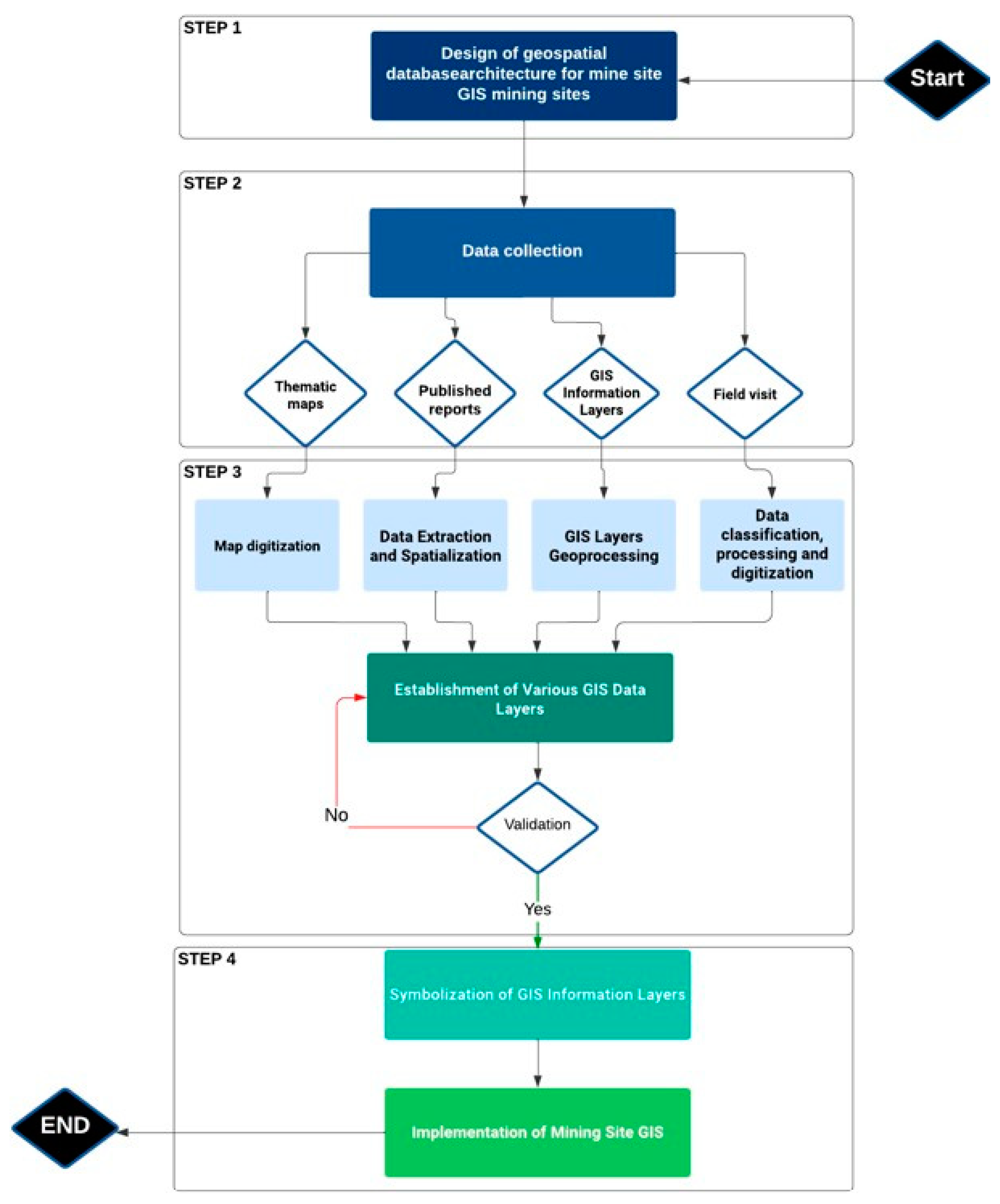
2.2. Methodological Approach

The methodology shown in Figure 2 was adopted in the development of the GIS-based database. The flowchart describes the stages of the process; the first step consisted of the design of the environmental geodatabase schema, and this involved defining the data entities and relationships. Specifically, this step involved the fundamental data classes, the layers of information that contributed to the data structure, and the attributes associated with each data class. Following the schema design, the next phase involved the acquisition of raw data from various sources. This encompassed gathering thematic maps, published reports, and relevant layers of spatial information. The acquired raw data underwent geotreatment processes. These processes involved spatial analysis techniques aimed at enhancing data quality and relevance. Geotransformation, fusion, and data cleaning procedures were applied to prepare the raw data for integration into the geospatial database. Subsequently, the structured geospatial database was implemented. The organized data layers, reflecting the earlier schema design, were integrated into the database architecture. Upon database implementation, attention was directed towards symbolizing the information layers. Each layer was visually represented through distinct symbols and colors, aiding in effective data interpretation. This visual aspect enhanced the communicative potential of the geospatial information. The final stages of the methodology encompassed the exploitation of data. This involved executing both attribute and spatial queries to extract specific insights from the database. Geoprocessing tools, including techniques such as buffering, were employed to analyze spatial relationships and patterns within the dataset.

2.3. Geospatial Database Design

The geospatial database system was designed to facilitate the collection of a wide range of data essential for decisionmakers and represents the key to decision-making. The importance of our database development lies in the quality and availability of the data for processing and interpretation, enabling the dataset to be linked and the various factors to be identified, while minimizing uncertainty and establishing links between the elements of the database [29,30]. The designed system, as illustrated in Figure 3, was modeled using the Conceptual Data Model (CDM) by PowerACM software 15.1 based on the Merise method with the aim of emphasizing the modeling of entities and their relationships in the context of database [31]. This database model comprises various classes, with each class encompassing entities specifically chosen for the subsequent study, as shown in Figure 4, and attributes modeled on a relational structure. A set of relationships has been defined between entities, using primary and foreign keys. This approach to data modeling can be broadly applied, extending its relevance to mine site localization and the assessment of pollution levels at any mining location.

2.4. Data Collection and Processing

2.4.1. Mine Sites

Data relating to Moroccan mines were collected as part of this study by means of field trips, using maps provided by the Ministry of Energy Transition and Sustainable Development and Regional Information Systems on the Environment and Sustainable Development (SIREDD) [34,35], and also by examining reports provided by mining companies.

2.4.2. Mining Waste

To accurately delineate mining waste areas, a pointing method was used [12]. This approach consisted of visually locating and identifying specific points where mine discharges occurred based on information provided in reports and field observations. Using this pointing method, it was possible to obtain reliable, localized data on mine waste areas. Laboratory tests and reports facilitated the determination of whether mine waste generates acid mine drainage (AMD), a crucial factor in evaluating the environmental impact of mining activities in Morocco.

2.4.3. Geology

The geological data were acquired from the official website of the Ministry of Energy Transition and Sustainable Development [34]. This information was used as a starting point for detailed mapping of the geological faults. Mapping was carried out with the aim of assessing geological risk while identifying particularly favorable geological facies. This approach enabled us to target potential areas rich in water resources or valuable minerals, paving the way for a better understanding of geological opportunities in the study area.

2.4.4. Administrative Subdivision and Urban Agglomeration

Data on regions, provinces, communes, cities, villages, and agglomerations were collected from the website of the Ministry of National Planning, Housing, and Urban Policy [36].

2.4.5. Transport Facilities

The data used for this study were acquired from the official website of the Ministry of Equipment and Water, namely information on the road network, the rail network, railway stations, ports, and airports [37]. These raw datasets underwent a rigorous geoprocessing phase, geoprocessing techniques included data cleaning, coordinate referencing, integration of disparate datasets, and spatial analysis. This geoprocessing effort was essential in creating a robust and informative spatial database that formed the foundation for our subsequent analyses and insights.

2.4.6. Forest and Ecological Sites

For the purposes of vegetation mapping, natural resource monitoring, and environmental impact assessment, the data were retrieved from the official website of the National Water and Forestry Agency and the reports published. In order to compare the data with reality, we used remote sensing to calculate the Modified Difference Vegetation Index (MDVI) for certain regions and thus identify the state of the vegetation. For the site of biological and ecological interest (SIBE), the data used were those obtained from the official site of the Center of Information Exchange on Biodiversity of MOROCCO [38,39]. For the oasis information layer, data collection was based on the outcomes of the oases study, which involved assessing agrodiversity in oasis agro-ecosystems. These data were digitized to create the layer [40,41].

2.4.7. Water Resources

Information on dams, watersheds, and water basin agencies was extracted from the website of the Moroccan Ministry of Equipment and Water. For hydrological networks, extraction was carried out using the Digital Terrain Model (DTM) [40]. The extraction process involved geoprocessing to correct errors in the DTM, determining flow directions in the corrected DTM, calculating the amount of water for each pixel using the spatial analyst tools hydrology ‘Flow Accumulation’, then defining the density of the hydrographic network and converting the hydrographic network from pixel format to vector format [38].

2.5. The Implementation of the GIS-Based Environmental Database

The choice of ArcGIS 10.2 as software was based on the variety and flexibility of its functionalities. ArcGis meets the requirements of GIS program, with numerous powerful geospatial analysis tools such as proximity and intersection analysis, using predefined toolboxes, yet the ability to use spatial queries with SQL language, as well as its simplicity of integrating and manipulating the geodatabase, and also visualization and mapping capabilities [42]. To import the database into the ArcGIS software environment, a geodatabase project was created using the ArcCatalog module. This project consisted of six main classes of essential data that had been previously identified, processed, and imported. For example, the water resources dataset included data on watersheds, hydraulic networks, basin hydraulic agencies, dams, and groundwater. Then, it was necessary to establish relationships between entities within the database. This was accomplished using primary keys, foreign keys, and cardinality, which were defined during the design phase of the database. And as known, the information sources resulted in the downloaded data were not being directly usable due to differences in origin, format, projection system, and attribute table structure. Hence, there was a need to preprocess the data to standardize the information. The downloaded spatial component files were imported into an initial geospatial database as feature classes, projected into the World Geodetic System 1984 (WGS84) coordinate system [43].

3. Results

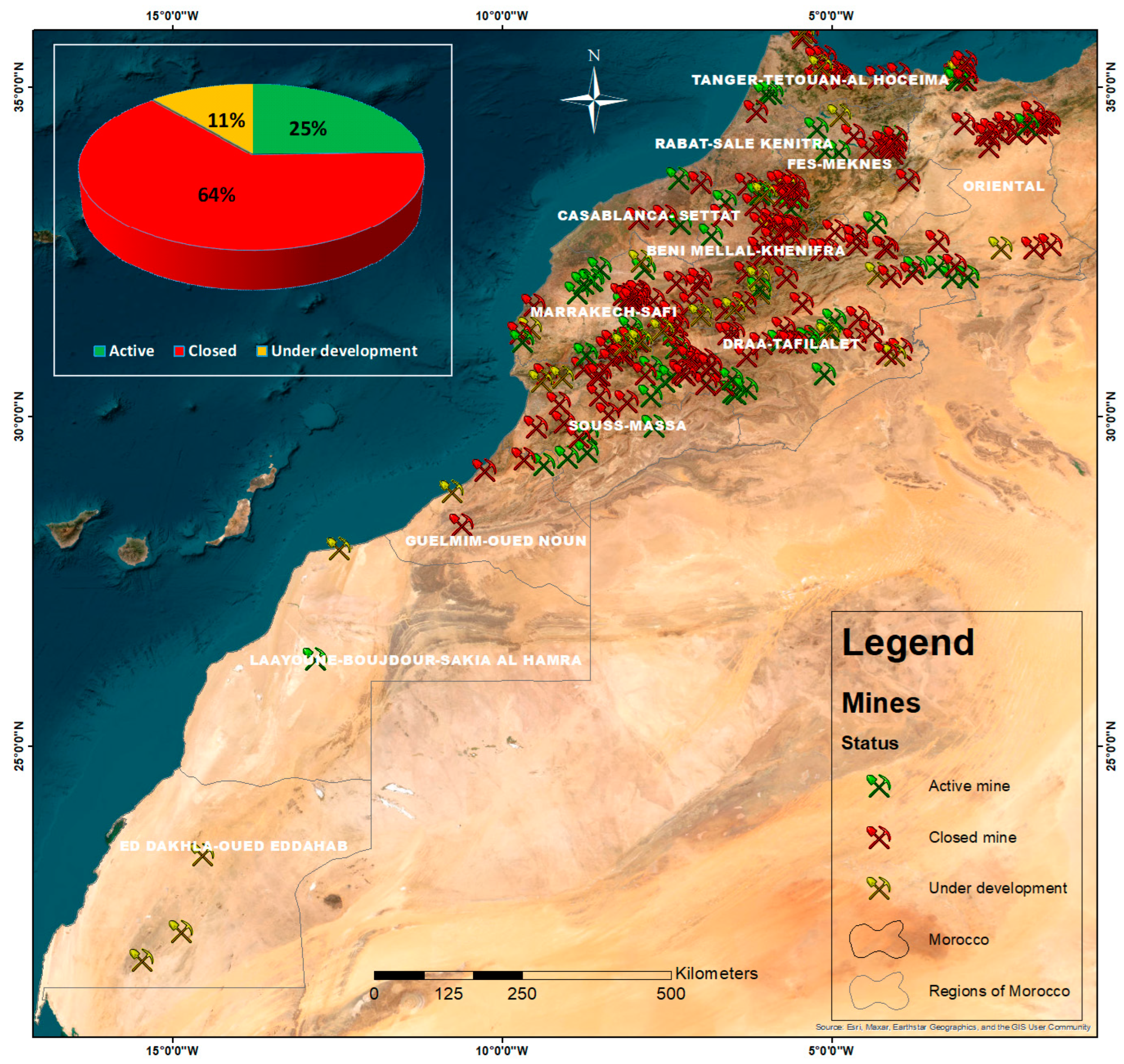
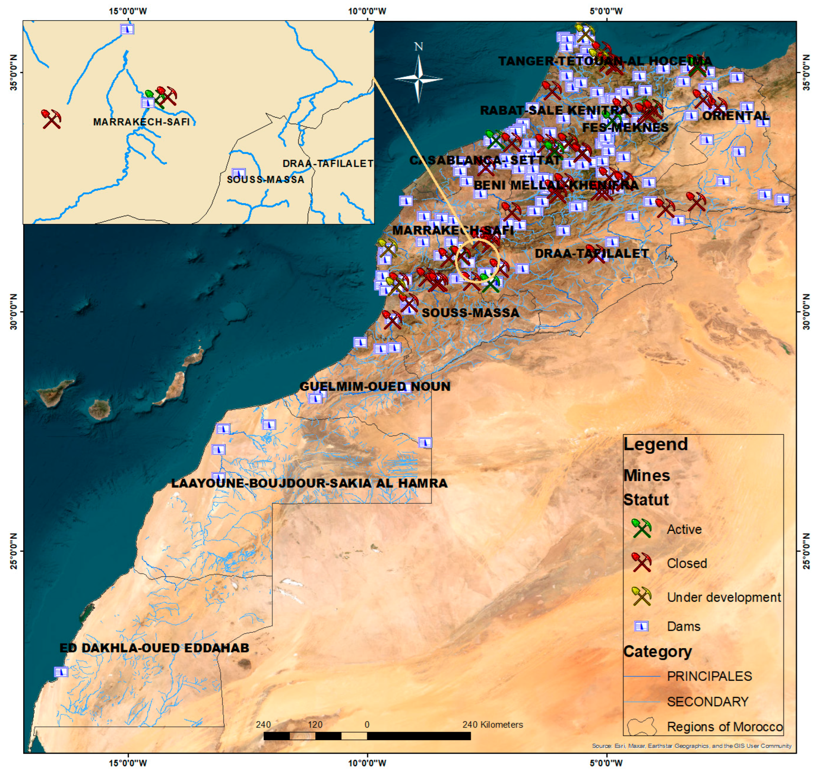
3.1. Distribution of Mines According to Their Status

The total number of Moroccan mines taken into account for this analysis was 257, including those in operation, those that have been closed, and those under development. Figure 5 shows that up to 165 mines (64% of the total) are already closed; 63 mines (25%) are active and regularly operated, and 29 mines (11%) are under development. Based on those results, the high percentage of closed mines raises questions about the factors contributing to their closure. Various factors such as resource depletion, economic viability, regulatory compliance, and environmental concerns represent potential reasons for their closure.

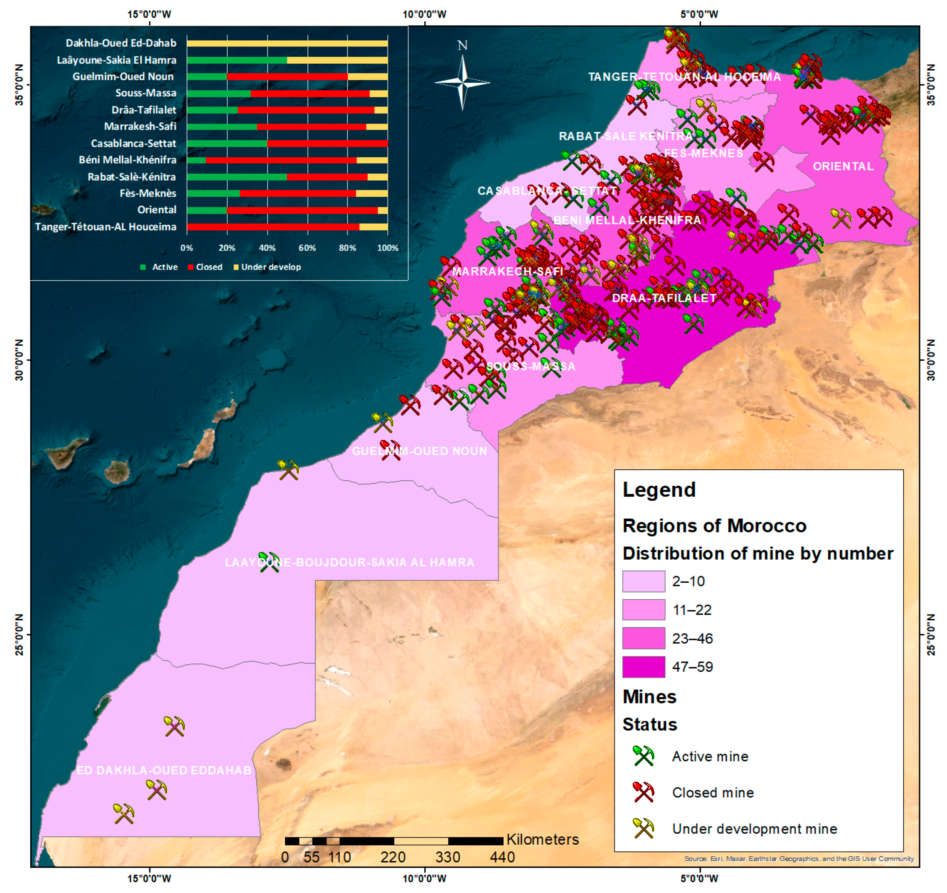
3.2. Distribution of Mines in Morocco Regions

One of the uses of this database is to evaluate the spread of mines across the Moroccan 12 regions to help the government bodies and stakeholders make informed decisions about regional development, industrial policies, and environmental conservation strategies. The distribution, as depicted in Figure 6, underscores concentration disparities, with some regions exhibiting a higher density of mines, while others display a limited presence. Table 1 highlights the Drâa-Tafilalet region as having the highest concentration of mines, accounting for 59 (22.96% of the total), followed by Marrakesh-Safi with 46 (17.90%) and Oriental with 40 (15.56%). Regarding active mine status, Marrakesh-Safi leads with 16 active mines (25.40% of the total), trailed by Drâa-Tafilalet with 15 mines (23.81%) and Oriental with 8 mines (12.70%). This spatial variance is tightly correlated with the geological abundance of these regions. The overlay of regional information layers information and metallogenic distribution as shown in Figure 1 shows geological conditions conducive to the formation of mineral deposits and metallogenic mineralization conducive to mining rich in metals such as lead (Pb), zinc (Zn), and copper (Cu). And from an environmental point of view, this distribution Figure 6 represents an invaluable source of information on the size of the population that both benefits from the presence of mining activity and is potentially exposed to its environmental risks.

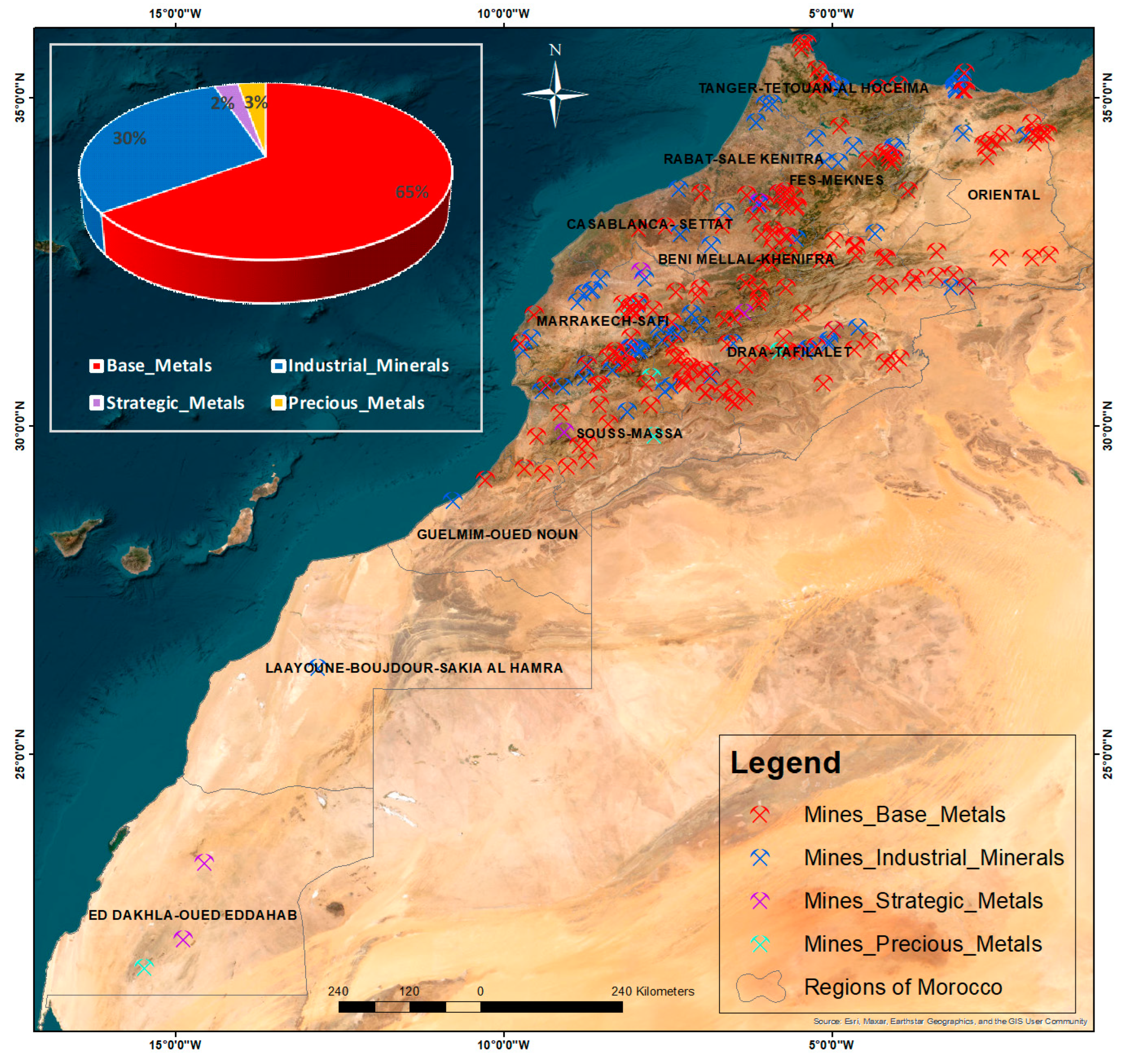
3.3. Distribution of Moroccan Mines by Ore Category

In the mining sector, excluding fuel mines, metals and minerals are classified into different categories based on their economic value, utilization, and strategic importance in development. Generally, mines are distributed as follows: base metals, mines for industrial minerals, precious metal mines, and mines of strategically important metals. Our geospatial database helps determine the distribution of mines according to each ore category. Its aim is to offer a comprehensive perspective on the presence of each type of ore in various regions. Through attributed queries used to generate Figure 7, the findings reveal a predominance of base metal mines, with 161 mines. In addition, the survey identifies 74 mines primarily dedicated to industrial minerals, such as phosphate, talc, mica, barite, and fluorite. Moreover, the assessment records seven mining locations specializing in precious metals, particularly silver and gold, as well as six strategic mines [44] known for iron (Fe), tungsten (W), tin (Sn), and nickel (Ni), which are considered critical and strategic materials due to growing demand, high supply risk, and limited substitution possibilities. These strategic ores fulfill the conventional criticality criteria, which include import dependency, the geographical concentration of producers, low political stability, and export restrictions. Additionally, they satisfy the criteria of geological availability within Morocco and are recognized in the list of critical minerals of Morocco’s main international partners [45].

3.4. Mines and Water Resources

3.4.1. Distribution of Mines According to Watersheds

The elaborated database is instrumental in assessing risks impacting water resources in Morocco. With 22 watersheds and 10 hydrological basin agencies, each watershed is aligned with its corresponding hydrological basin agency. The findings, illustrated in Figure 8, show the distribution of the mines classified by their status and aligned with the respective watersheds affiliated with the hydrological basin agencies. It shows that the Sous Massa Draa watershed agency has the highest number of mines, with 56 mines, followed by the Tenssift watershed agency with 34 mines, the Oum Er Rabei agency with 32 mines, and the Guiz Ziz Rheris agency with 32 mines. These results provide insight into the spatial relationship between mining operations and the water management infrastructure. It serves as a decision-making tool for these agencies, helping in the location of mines within their operational areas to aid in the preservation of water resources; it also enables a comprehensive understanding of the impacts of pollution, thereby facilitating the planning of targeted remediation measures.

3.4.2. Distribution of Mines According to Their Proximity to Dams and Hydrographic Networks

The identification of mines impacting these essential water resources stemmed from a process involving the determination of mine buffer zones through the variation of radius. We opted for a 5 km radius to demarcate our buffer zones, which revealed a substantial inclusion of numerous dams and hydrographic networks, respectively, within these zones. This spatial analysis was further refined using intersect attribute queries, pinpointing mines significantly intersecting with dam locations and hydrographic networks, respectively. Figure 9 reveals that 46 mines categorized as ‘closed’ exhibit a notably extensive 5 km buffer zone intersecting with dams and hydrological networks, 8 categorized as ‘active’, and 4 categorized as ‘under development’. This observation signifies that abandoned or closed mines exert a more significant spatial influence on critical water resources, given that the total of 46 closed mines represents 18% of the total number of Moroccan mines. The quality of water resources may already be affected during the active phase of mining, but the most significant negative impacts often reappear after the mine has ceased operations, particularly in the case of abandoned mines. The Zeïda, Mibladen, and Aouli mines, all abandoned and located near the Moulouya River, are notable examples. Analyses of soil and water samples from these sites show contamination with heavy metals such as lead (Pb), zinc (Zn), arsenic (As), cadmium (Cd), and copper (Cu). This example of contamination illustrates the substantial impact a mine can have on a water system. It highlights not only the importance of geographical location but also other factors such as tailings’ location, climatic conditions, and wind and water erosion [46].
By incorporating various data inputs and parameters into a global geospatial database, the results will represent a significant step forward, facilitating a targeted assessment of the environmental implications and potential risks posed by the mining industry on water resources. This evaluation will be instrumental in identifying mines with higher risks to the water resource, allowing better communication with authorities and preventing the development of similar situations in future mining projects.

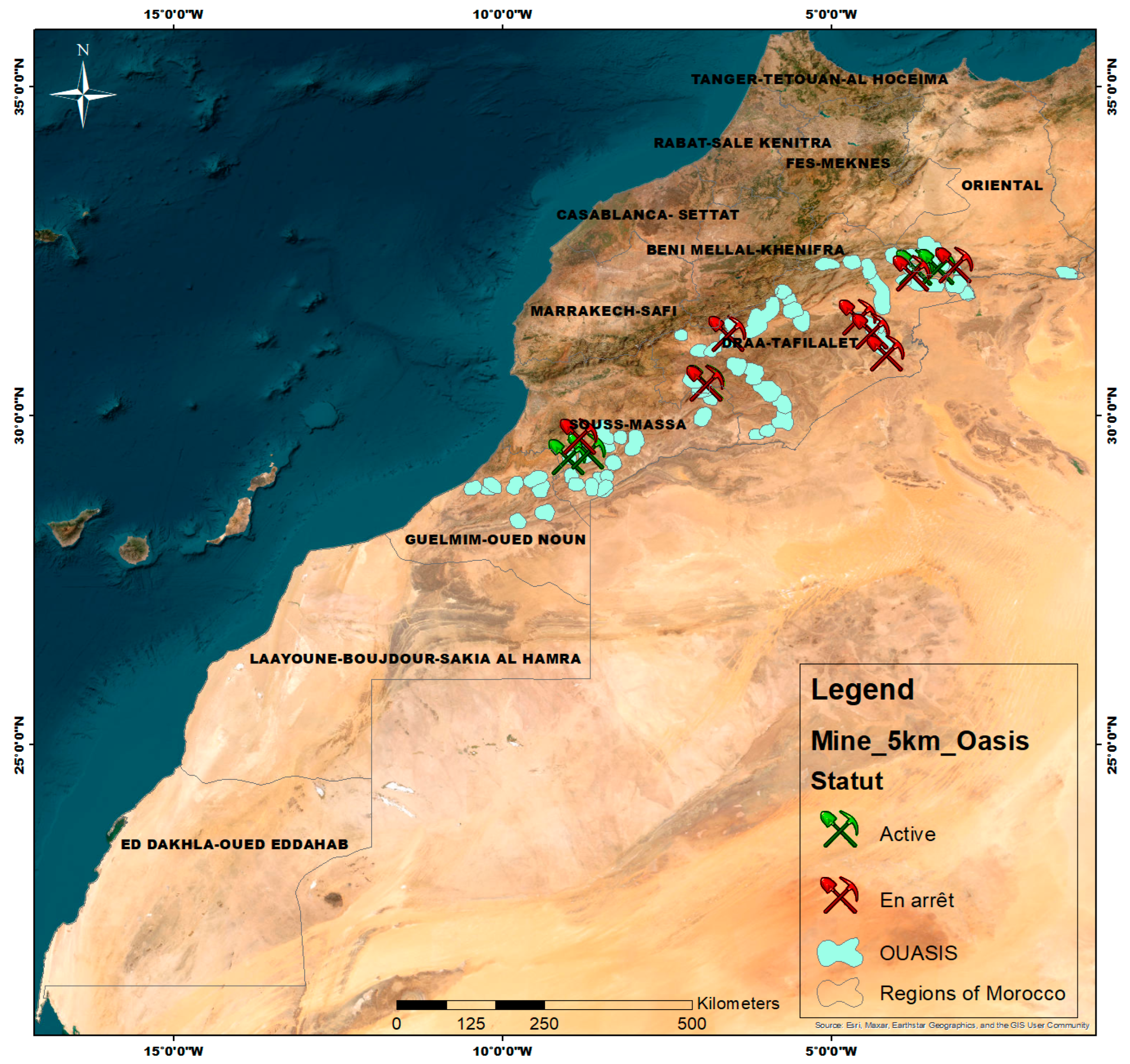
3.5. Distribution of Mines According to Their Proximity to Oases

In this study, a spatial analysis was carried out to assess the potential impact of mining activities on the oases. Using ArcGIS, geospatial layers of oases and mines were superimposed. By utilizing the “Select by Location” query with a 5 km radius around the oases, we identified the mines in the immediate vicinity of these fragile ecosystems. The results of this analysis, as presented in Figure 10, show that 12 mines, including 4 active and 8 closed, are located within a 5 km radius of the oases. Additionally, the regional distribution of the mines highlights the influence of climate, as the oases are primarily located in three major regions: Oriental, Drâa-Tafilalet, and Souss-Massa. These regions are known for their arid to semi-arid climate, characterized by scarce precipitation and high evaporation due to elevated temperatures [47]. Identifying the mines in this critical zone allows us to quantify the exposure of oases to risks of contamination and overexploitation of water resources. Indeed, mining activities near oases can lead to a decrease in groundwater levels and pollution of groundwater by toxic chemicals used in the mining process [48]. These effects compromise the viability of the oases, which depend on a clean and stable water supply.
The results underscore the necessity for stringent control measures to ensure the sustainability of these oases. They provide essential information for policymakers and environmental managers aiming to balance economic development with the conservation of natural resources. Sustainable water resource management in these regions requires continuous monitoring and adaptive management strategies to minimize the negative impacts of mining activities [49].

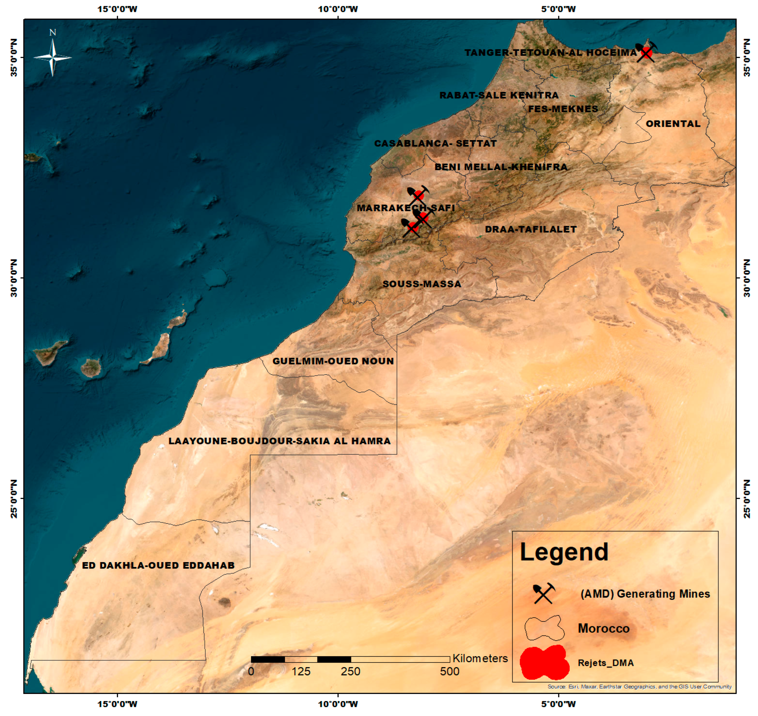
3.6. Mines and Acid Mine Drainage (AMD) Potential

Acid mine drainage (AMD) is a significant environmental issue associated with mining activities, particularly in regions with limited water resources. AMD occurs when sulfide minerals exposed during mining operations oxidize in the presence of air and water, producing sulfuric acid and dissolved iron, along with other toxic heavy metals such as lead, cadmium, and arsenic. Using collected data on mine waste to identify mines generating AMD in Morocco, the outcome of this analysis, as shown in Figure 11, reveals a total of four mines: the Kettara, Hajjar, Ouixane, and Azegour mines. The identification of these sites as significant AMD sources allows for a detailed assessment of the contamination risk posed by mining activities. The Kettara mine, for example, has shown severe contamination of surrounding soils and water bodies [50], while the Hajjar and Azegour mines produce effluents with high concentrations of acid and metals, which pose significant environmental hazards. Acidic effluents can lead to the acidification of nearby water bodies, mobilizing heavy metals from sediments and exacerbating water quality issues, affecting both aquatic ecosystems and human health. Long-term impacts of AMD include soil degradation and loss of biodiversity, as acidic conditions hinder plant growth and reduce soil microbial activity. Effective management of AMD involves minimizing sulfide mineral exposure and employing remedial actions like limestone neutralization and constructed wetlands [51]. Implementing these strategies in Morocco requires robust regulatory frameworks and collaboration between stakeholders to ensure sustainable water resource management and ecosystem protection. This study highlights the importance of identifying and managing AMD-generating sites to mitigate environmental impacts, providing valuable insights for developing strategies that balance economic development with ecological preservation.

3.7. Prioritized Mining Sites

One of the primary aims of utilizing this geospatial database is to assess the environmental impact of mining activities and identify priority mines requiring immediate intervention. By employing layer superposition and attribute queries based on previous findings regarding the impact of mines on dams, oases, hydrographic networks, and the potential for acid mine drainage (AMD), the analysis revealed nine priority mines, as presented in Figure 12. Among these, Kettara, Tansrift, Sidi Boubker, Zaida, Mibladen, Erdouz, Sidi Lahcen, Sidi Bou Othmane, and Azegour are closed. These mines exhibit significant intersections with crucial environmental and infrastructural elements, highlighting their substantial impact and emphasizing the urgent need for targeted intervention and remedial actions. The identification of these priority mines underscores the critical environmental challenges posed by historical mining activities. It also provides a vision of the potential outcomes: implementing a comprehensive rehabilitation plan for these mines can mitigate environmental damage, while abandoning them without any preventive measures will likely lead to an environmental catastrophe.

4. Conclusions

The study aimed to create a GIS-based geospatial database model for assessing the environmental impacts of mining, using Morocco as a relevant case study due to its extensive mining activities. The main process involved the architecture and design of the database, data collection, and its implementation in ArcGIS software. To exemplify the utility of our geospatial database, GIS mapping techniques and queries were employed. This included comprehensive mapping of mines according to their activity status and ore types throughout Morocco, followed by an analysis of priority mines based on critical ecological features such as dams, hydrographic networks, oases, and the potential for acid mine drainage (AMD). Each layer of information was analyzed based on its proximity to the mines and the status of the mines’ activity.
The objective was to utilize this database to promote environmental stewardship by addressing abandoned mines and determining those that need to be prioritized. The results of aggregating all the analyses identified eight closed mines: Kettara, Tansrift, Sidi Boubker, Zaida, Mibladen, Erdouz, Sidi Lahcen, Sidi Bou Othmane, and Azegour, which require immediate treatment to mitigate their environmental impact. The proposed methodology is not limited to Morocco and can be adapted to other countries facing similar environmental challenges. By integrating diverse spatial datasets, this approach provides a transferable framework to assess the impacts of mining on ecosystems worldwide. In addition, the study offers a new perspective for future mining activities and investments by identifying environmentally sensitive areas where stricter monitoring and sustainable practices should be prioritized. The proposed methodology is not limited to Morocco and can be adapted to other countries facing similar environmental challenges related to mining. By integrating diverse spatial datasets, this approach provides a scalable and transferable framework to assess the impacts of mining on ecosystems worldwide. However, certain limitations should be acknowledged. The precision of the analysis depends on the availability and quality of spatial data, which can vary between regions. Furthermore, while the study identifies priority sites based on proximity analysis, future research could focus on integrating real-time environmental monitoring data. This comprehensive geospatial database serves as the foundational element for a web-based GIS decision support system for the Moroccan mining sector, aimed at decisionmakers, investors, and stakeholders interested in sustainable mining practices.

Author Contributions

Conceptualization, S.B. and A.K.; methodology, S.B., A.K. and M.E.A.; software, S.B.; validation, S.B., A.K., L.Z. and M.E.A.; formal analysis, S.B., A.K. and M.E.A.; investigation, S.B. and A.K.; resources, S.B., A.K. and M.E.A.; writing—original draft preparation, S.B., A.K., L.Z. and M.E.A.; writing—review and editing, S.B., A.K., L.Z. and M.E.A.; supervision, S.B., A.K., L.Z. and M.E.A. All authors have read and agreed to the published version of the manuscript.

Funding

This research received no external funding.

Data Availability Statement

The original contributions presented in the study are included in the article; further inquiries can be directed to the corresponding author.

Conflicts of Interest

The authors declare no conflicts of interest.

References

  1. Ji, K.; Kim, J.; Lee, M.; Park, S.; Kwon, H.J.; Cheong, H.K.; Jang, J.Y.; Kim, D.S.; Yu, S.; Kim, Y.W. Assessment of exposure toheavy metals and health risks among residents near abandoned metal mines in Goseong, Korea. Environ. Pollut. 2008, 178, 322–328. [Google Scholar] [CrossRef] [PubMed]
  2. Paternie, E.D.E.; Hakkou, R.; Nga, L.E.; Oyono, L.D.B.; Bessa, A.Z.E.; Oubaha, S.; Khalil, A. Geochemistry and geostatistics for the assessment of trace elements contamination in soil and stream sediments in abandoned artisanal small-scale gold mining (Bétaré-Oya, Cameroon). Appl. Geochem. 2023, 150, 105592. [Google Scholar] [CrossRef]
  3. Opara, C.B.; Blannin, R.; Ebert, D.; Frenzel, M.; Pollmann, K.; Kutschke, S. Bioleaching of metal (loid) s from sulfidic mine tailings and waste rock from the Neves Corvo mine, Portugal, by an acidophilic consortium. Miner. Eng. 2022, 188, 107831. [Google Scholar] [CrossRef]
  4. Córdoba-Tovar, L.; Marrugo-Negrete, J.; Barón, P.A.R.; Díez, S. Ecological and human health risk from exposure to contaminated sediments in a tropical river impacted by gold mining in Colombia. Environ. Res. 2023, 236, 116759. [Google Scholar] [CrossRef]
  5. Giri, S.; Tiwari, A.K.; Mahato, M.K.; Singh, A.K. Spatio-temporal variations of metals in groundwater from an iron mining impacted area: Assessing sources and human health risk. Total Environ. Res. Themes 2023, 8, 100070. [Google Scholar] [CrossRef]
  6. MTEDD. Available online: https://mtedd.gov.ma/index.php?lang=en (accessed on 29 July 2023).
  7. Alexander, A.C.; Ndambuki, J.M. Impact of mine closure on groundwater resource: Experience from Westrand Basin-South Africa. Phys. Chem. Earth Parts A/B/C 2023, 131, 103432. [Google Scholar] [CrossRef]
  8. Hou, Y.; Zhao, Y.; Lu, J.; Wei, Q.; Zang, L.; Zhao, X. Environmental contamination and health risk assessment of potentially toxic trace metal elements in soils near gold mines–A global meta-analysis. Environ. Pollut. 2023, 330, 121803. [Google Scholar] [CrossRef]
  9. Khalil, A.; Taha, Y.; Benzaazoua, M.; Hakkou, R. Applied Methodological Approach for the Assessment of Soil Contamination by Trace Elements around Abandoned Coal Mines—A Case Study of the Jerada Coal Mine, Morocco. Minerals 2023, 13, 181. [Google Scholar] [CrossRef]
  10. El Adnani, M.; Rodriguez-Maroto, J.M.; Sbai, M.L.; Nejmeddine, A. Impact of polymetallic mine (Zn, Pb, Cu) residues on surface water, sediments and soils at the vicinity (Marrakech, Morocco). Environ. Technol. 2007, 28, 969–985. [Google Scholar] [CrossRef]
  11. El Azhari, A.; Rhoujjati, A.; Hachimi, M.L.E. Assessment of heavy metals and arsenic contamination in the sediments of the Moulouya River and the Hassan II Dam downstream of the abandoned mine Zeïda (High Moulouya, Morocco). J. Afr. Earth Sci. 2016, 119, 279–288. [Google Scholar] [CrossRef]
  12. Wolkersdorfer, C. Water Management at Abandoned Flooded Underground Mines: Fundamentals, Tracer Tests, Modelling, Water Treatment. In Springer Science & Business Media; Springer: Berlin/Heidelberg, Germany, 2008. [Google Scholar]
  13. Khalil, A.; Hanich, L.; Bannari, A.; Zouhri, L.; Pourret, O.; Hakkou, R. Assessment of soil contamination around an abandoned mine in a semi-arid environment using geochemistry and geostatistics: Pre-work of geochemical process modeling with numerical models. J. Geochem. Explor. 2013, 125, 117–129. [Google Scholar] [CrossRef]
  14. Khalil, A.; Argane, R.; Benzaazoua, M.; Bouzahzah, H.; Taha, Y.; Hakkou, R. Pb–Zn mine tailings reprocessing using centrifugal dense media separation. Miner. Eng. 2019, 131, 28–37. [Google Scholar]
  15. Ech-Charef, A.; Dekayir, A.; Jordán, G.; Rouai, M.; Chabli, A.; Qarbous, A.; El Houfy, F.Z. Soil heavy metal contamination in the vicinity of the abandoned Zeïda mine in the Upper Moulouya Basin, Morocco. Implications for airborne dust pollution under semi-arid climatic conditions. MiJournal Afr. Earth Sci. 2023, 198, 104812. [Google Scholar]
  16. Goumih, A.; El Adnani, M.; Hakkou, R.; Benzaazoua, M.; Ouhamdouch, S.; Boumehdi, M.A. Evaluation of the long-term contaminated neutral drainage CND generation potential of waste rock piles at the abandoned Zn-Pb erdouz mine (occidental high atlas, Morocco). Min. Metall. Explor. 2022, 39, 643–654. [Google Scholar] [CrossRef]
  17. El Adnani, M.; Plante, B.; Benzaazoua, M.; Hakkou, R.; Bouzahzah, H. Tailings weathering and arsenic mobility at the abandoned Zgounder silver mine, Morocco. Mine Water Env. 2016, 35, 508–524. [Google Scholar]
  18. Khalil, A.; Hanich, L.; Hakkou, R.; Lepage, M. GIS-based environmental database for assessing the mine pollution: A case study of an abandoned mine site in Morocco. J. Geochem. Explor. 2014, 144, 468–477. [Google Scholar]
  19. Kulawiak, M.; Prospathopoulos, A.; Perivoliotis, L.; Kioroglou, S.; Stepnowski, A. Interactive visualization of marine pollution monitoring and forecasting data via a Web-based GIS. Comput. Geosci. 2010, 36, 1069–1080. [Google Scholar]
  20. Abuhasel, K. Geographical information system based spatial and statistical analysis of the green areas in the cities of Abha and Bisha for environmental sustainability. ISPRS Int. J. Geo-Inf. 2023, 12, 333. [Google Scholar] [CrossRef]
  21. Kourgialas, N.N.; Hliaoutakis, A.; Argyriou, A.V.; Morianou, G.; Voulgarakis, A.E.; Kokinou, E.; Soupios, P. A web-based GIS platform supporting innovative irrigation management techniques at farm-scale for the Mediterranean island of Cret. Sci. Total Environ. 2022, 842, 156918. [Google Scholar]
  22. García-Ayllón, S.; Martínez, G. Analysis of correlation between anthropization phenomena and landscape values of the territory: A GIS framework based on spatial statistics. ISPRS Int. J. Geo-Inf. 2023, 12, 323. [Google Scholar]
  23. Mas, J.F.; Puig, H.; Palacio, J.L.; Sosa-López, A. Modelling deforestation using GIS and artificial neural networks. Environ. Model. Softw. 2004, 19, 461–471. [Google Scholar] [CrossRef]
  24. Ferla, G.; Caputo, P.; Colaninno, N.; Morello, E. Urban greenery management and energy planning: A GIS-based potential evaluation of pruning by-products for energy application for the city of Milan. Renew. Energy 2020, 160, 185–195. [Google Scholar] [CrossRef]
  25. Merbitz, H.; Buttstädt, M.; Michael, S.; Dott, W.; Schneider, C. Urban greenery management and energy planning: GIS-based identification of spatial variables enhancing heat and poor air quality in urban areas. Appl. Geogr. 2012, 33, 94–106. [Google Scholar] [CrossRef]
  26. Dentoni, V.; Lai, A.; Pinna, F.; Cigagna, M.; Massacci, G.; Grosso, B. A comprehensive methodology for the visual impact assessment of mines and quarries. Environ. Impact Assess. Rev. 2023, 102, 107199. [Google Scholar] [CrossRef]
  27. Fornasaro, S.; Morelli, G.; Rimondi, V.; Fagotti, C.; Friani, R.; Lattanzi, P.; Costagliola, P. A GIS-based map of the Hg-impacted area in the Paglia River basin (Monte Amiata Mining District–Italy): An operational instrument for environmental management. J. Geochem. Explor. 2022, 242, 107074. [Google Scholar] [CrossRef]
  28. Saha, A.; Gupta, B.S.; Patidar, S.; Martínez-Villegas, N. Optimal GIS interpolation techniques and multivariate statistical approach to study the soil-trace metal (loid) s distribution patterns in the agricultural surface soil of Matehuala, Mexico. J. Hazard. Mater. Adv. 2023, 9, 100243. [Google Scholar] [CrossRef]
  29. McIntosh, A.C.; Cushing, J.B.; Nadkarni, N.M.; Zeman, L. Database design for ecologists: Composing core entities with observations. Ecol. Inform. 2007, 2, 224–236. [Google Scholar] [CrossRef]
  30. Liang, T.; Werner, T.T.; Heping, X.; Jingsong, Y.; Zeming, S. A global-scale spatial assessment and geodatabase of mine areas. Glob. Planet. Change 2021, 204, 103578. [Google Scholar] [CrossRef]
  31. Svob, S.; Arroyo-Mora, J.P.; Kalacska, M. The development of a forestry geodatabase for natural forest management plans in Costa Rica. For. Ecol. Manag. Change 2014, 327, 240–250. [Google Scholar] [CrossRef]
  32. Wang, X.; Xie, H. A review on applications of remote sensing and geographic information systems (GIS) in water resources and flood risk management. Water 2018, 10, 608. [Google Scholar] [CrossRef]
  33. Tona, A.U.; Demir, V.; Kuşak, L.; Yakar, M. Su kaynakları mühendisliğinde CBS’nin kullanımı. Türkiye Coğrafi. Bilgi. Sist. Derg. 2022, 4, 23–33. [Google Scholar]
  34. Ministere de l’Energie, des Mines et de l’Environnement. Available online: https://www.mem.gov.ma/ (accessed on 29 July 2023).
  35. Dematerialisation de la Procedure des ’Etudes d’Impacts. Available online: https://www.environnement.gov.ma/fr (accessed on 29 July 2023).
  36. Ministere de l’Urbanisme, de l’Amenagement du Territoire, de l’Eau et de l’Environnement. Available online: https://www.muat.gov.ma (accessed on 29 July 2023).
  37. Ministere de l’Equipement, de l’Eau et de l’Environnement. Available online: http://www.equipement.gov.ma (accessed on 29 July 2023).
  38. Formations Forestiéres. Available online: http://www.eauxetforets.gov.ma/ForetsMarocaines (accessed on 29 July 2023).
  39. CHM—Clearing-House Mechanism. Available online: https://ma.chm-cbd.net/ (accessed on 29 July 2023).
  40. An Overview of the Analysis Toolbox—ArcGIS Pro. Available online: https://pro.arcgis.com/en/pro-app/latest/tool-reference (accessed on 29 July 2023).
  41. Houssni, M.; El Mahroussi, M.; Sbih, H.B.; Kadiri, M.; Ater, M. Agriculture traditionnelle et agrodiversité dans les oasis du Sud du Maroc: Cas des oasis de la région Drâa-Tafilalet. In Proceedings of the Research and Innovation as Tools for Sustainable Agriculture, Food and Nutrition Security, MEDFORUM, Bari, Italy, 18–20 September 2018. [Google Scholar]
  42. López-Acevedo, F.J.; Escavy, J.I.; Herrero, M.J. Application of Spatial Data Mining to national mines inventories for exploration and land planning of high place-value mineral resources. The case of aggregates in Spain. Resour. Policy 2022, 79, 103096. [Google Scholar] [CrossRef]
  43. Johnston, K.; Ver Hoef, J.M.; Krivoruchko, K.; Lucas, N. Using ArcGIS Geostatistical Analyst; ESRI: Redlands, CA, USA, 2001; Volume 320. [Google Scholar]
  44. Lim, B.; Alorro, R.D.; Aylmore, M.; Grimsey, D. Complexation leaching of critical and strategic metals from nickel converter slag using organic acids. Miner. Eng. 2023, 201, 108167. [Google Scholar]
  45. Conseil Economique Social et Environnement. Available online: https://www.cese.ma/docs/les-minerais-strategiques-et-critiques/ (accessed on 29 July 2023).
  46. Iavazzo, P.; Ducci, D.; Adamo, P.; Trifuoggi, M.; Migliozzi, A.; Boni, M. Impact of past mining activity on the quality of water and soil in the High Moulouya Valley (Morocco). Water Air Soil Pollut. 2012, 223, 573–589. [Google Scholar]
  47. Bouchaou, L.; Tagma, T.; Boutaleb, S.; Hssaisoune, M.; El Morjani, Z.E.A. Climate change and its impacts on groundwater resources in Morocco: The case of the Souss-Massa basin. In Climate Change Effects on Groundwater Resources: A Global Synthesis of Findings and Recommendations; Taylor & Francis: Abingdon, UK, 2011; pp. 129–144. [Google Scholar]
  48. Ouhamdouch, S.; Bahir, M.; Ouazar, D.; Carreira, P.M.; Zouari, K. Evaluation of climate change impact on groundwater from semi-arid environment (Essaouira Basin, Morocco) using integrated approaches. Environ. Earth Sci. 2019, 78, 449. [Google Scholar] [CrossRef]
  49. Kusi, K.K.; Khattabi, A.; Mhammdi, N.; Lahssini, S. Prospective evaluation of the impact of land use change on ecosystem services in the Ourika watershed, Morocco. Land Use Policy 2020, 97, 104796. [Google Scholar]
  50. El Khalil, H.; El Hamiani, O.; Bitton, G.; Ouazzani, N.; Boularbah, A. Heavy metal contamination from mining sites in South Morocco: Monitoring metal content and toxicity of soil runoff and groundwater. Environ. Monit. Assess. 2008, 136, 147–160. [Google Scholar] [CrossRef]
  51. Skousen, J.G.; Ziemkiewicz, P.F.; McDonald, L.M. Acid mine drainage formation, control and treatment: Approaches and strategies. Extr. Ind. Soc. 2019, 6, 241–249. [Google Scholar]
Figure 1. Mineralization provinces of Morocco.
Water 17 00924 g001
Figure 2. Flowchart of the process followed for the elaboration of the database.
Water 17 00924 g002
Figure 3. Conceptual Data Model (CDM) diagram illustrating attributes, entities, and relationships between database elements, with an emphasis on logical data structure.
Water 17 00924 g003
Figure 4. Geospatial database architecture (SIBE: site of biological and ecological interest).
Water 17 00924 g004
Figure 5. Mapping the distribution of mines in Moroccan territory based on activity status: active, under development, closed, and their representative percentage.
Water 17 00924 g005
Figure 6. Graduated distribution of mines across Moroccan regions: from highest to lowest density.
Water 17 00924 g006
Figure 7. Classification and percentage distribution of Moroccan mines by ore types: base metals, strategic metals, precious metals, and industrial minerals.
Water 17 00924 g007
Figure 8. Distribution of mines by status across watersheds affiliated to hydrological basin agencies in Morocco.
Water 17 00924 g008
Figure 9. The localization of mines with a 5 km buffer radius of influence on dams and hydrological networks in Morocco.
Water 17 00924 g009
Figure 10. Map showing the mines’ localization 5 km adjacent to oases using intersect queries.
Water 17 00924 g010
Figure 11. Identification of mines with acid mine drainage potential: mapping AMD-risk mines.
Water 17 00924 g011
Figure 12. Mapping priority mines requiring urgent intervention.
Water 17 00924 g012
Table 1. Table of mines distribution in Moroccan regions depending on status.
RegionActiveClosedUnder-DevelopTotal MinesPopulation
Tanger-Tétouan-AlHouceima0122143,725,192
Oriental8302402,402,374
Fès-Meknès5113194,347,958
Rabat-Salè-Kénitra541104,769,423
Béni Mellal-Khénifra3245322,581,703
Casablanca-Settat23057,218,021
Marrakesh-Safi16255464,687,947
Drâa-Tafilalet15404591,673,773
Souss-Massa7132222,817,204
Guelmim-Oued Noun1315441,800
Laâyoune-Sakia El Hamra1012388,902
Dakhla-Oued Ed-Dahab0033165,250
Disclaimer/Publisher’s Note: The statements, opinions and data contained in all publications are solely those of the individual author(s) and contributor(s) and not of MDPI and/or the editor(s). MDPI and/or the editor(s) disclaim responsibility for any injury to people or property resulting from any ideas, methods, instructions or products referred to in the content.

