
From Hazard Maps to Action Plans: Comprehensive Flood Risk Mitigation in the Susurluk Basin

 , , ,
, , ,  , , and
Abstract
:1. Introduction
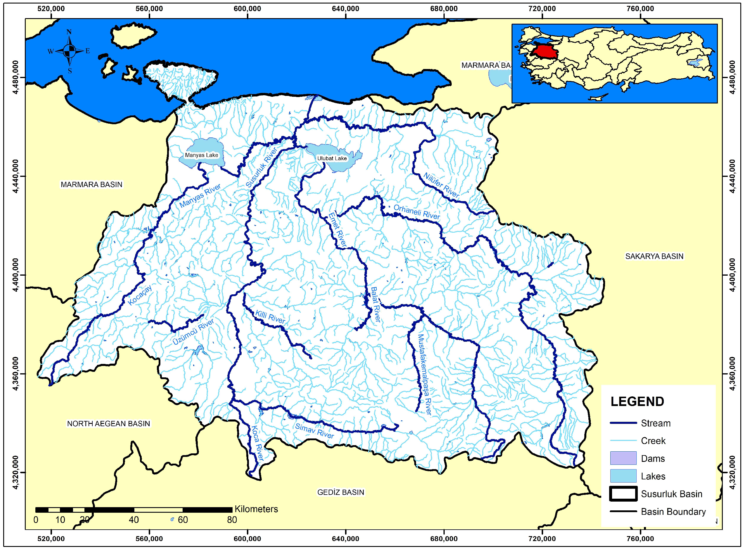
2. Study Area
3. Methodology
3.1. Hydrological Modeling
- –
- The basin model includes physical properties, such as basin area, stream connection points, and reservoir data.
- –
- The meteorological model is the part that defines the basin meteorology (such as precipitation, temperature, and flow values).
- –
- The control specifications contain information about the timing of the model, such as the time of the flood and the time interval to be used in the model.
- –
- The time series data belong to the part in which the meteorological time series to be used in the model are defined.
3.2. Hydraulic Modeling
4. Modeling Stages and Results
4.1. Preliminary Flood Risk Assessment (PFRA)
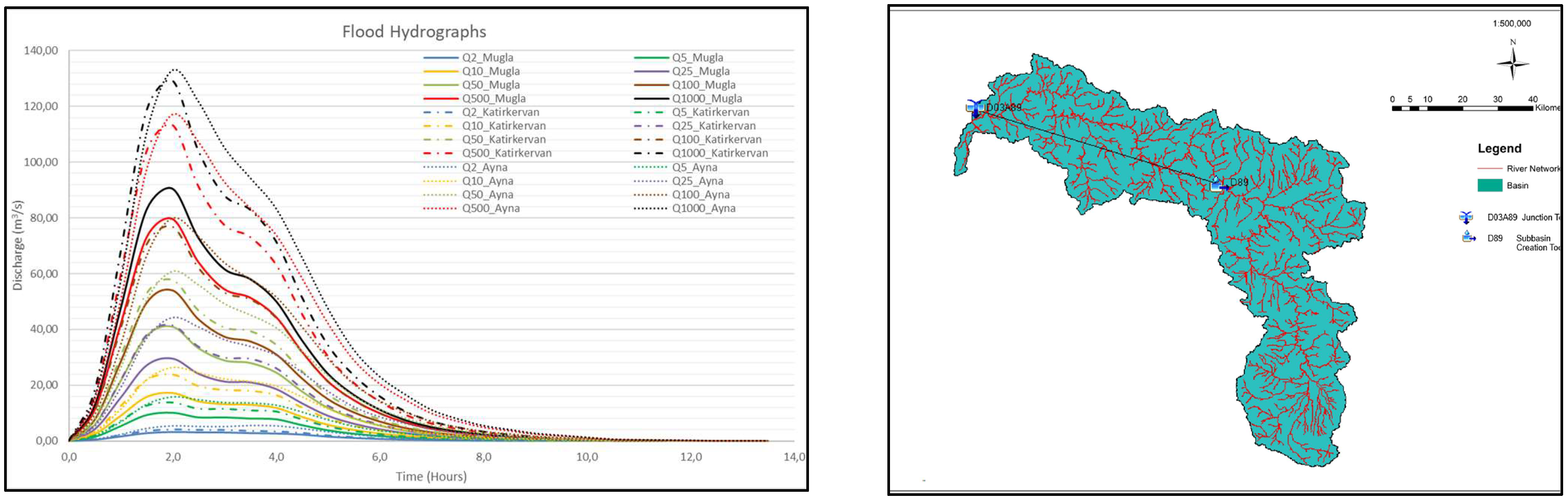
4.2. Hydrology Studies
4.3. Hydraulic Studies
4.4. Flood Inundation Maps
4.4.1. Map Studies
4.4.2. Hydrodynamic Model Studies
4.5. Flood Risk Maps
Response Capacity Analysis
5. Conclusions
Author Contributions
Funding
Data Availability Statement
Acknowledgments
Conflicts of Interest
References
- Hammond, M.J.; Chen, A.S.; Djordjević, S.; Butler, D.; Mark, O. Urban flood impact assessment: A state of the art review. Urban Water J. 2015, 12, 14–29. [Google Scholar] [CrossRef]
- Quiroga, V.M.; Kure, S.; Udo, K.; Mano, A. Application of 2D numerical simulation for the analysis of the February 2014 Bolivian Amazonia flood: Application of the new HEC-RAS version 5. Ribagua 2016, 3, 25–33. [Google Scholar] [CrossRef]
- European Commission, Directive 2007/60/EC of the European Parliament and of the Council of 23 October 2007 on the assessment and management of flood risks. Off. J. Eur. Union 2007, 288, 27–34.
- Horritt, M.S.; Bates, P.D. Evaluation of 1D and 2D numerical models for predicting river flood inundation. J. Hydrol. 2002, 268, 87–99. [Google Scholar] [CrossRef]
- Merwade, V.; Olivera, F.; Arabi, M.; Edleman, S. Uncertainty in flood inundation mapping: Current issues and future directions. J. Hydrol. Eng. 2008, 13, 608–620. [Google Scholar] [CrossRef]
- Pinos, J.; Timbe, L. Performance assessment of two-dimensional hydraulic models for generation of flood inundation maps in mountain river basins. Water Sci. Eng. 2019, 12, 11–18. [Google Scholar] [CrossRef]
- Salman, A.; Hassan, S.S.; Khan, G.D.; Goheer, M.A.; Khan, A.A.; Sheraz, K. HEC-RAS and GIS-based flood plain mapping: A case study of Narai Drain Peshawar. Acta Geophys. 2021, 69, 1383–1393. [Google Scholar] [CrossRef]
- Eini, M.; Kaboli, H.S.; Rashidian, M.; Hedayat, H. Hazard and vulnerability in urban flood risk mapping: Machine learning techniques and considering the role of urban districts. Int. J. Disaster Risk Reduct. 2020, 50, 101687. [Google Scholar] [CrossRef]
- Zhao, B.; Li, R. Improving flood hazard susceptibility assessment by integrating machine learning algorithms: A case study in China. Nat. Hazards 2024, 115, 1234–1256. [Google Scholar] [CrossRef]
- Nguyen, T.H.; Ricci, S.; Piacentini, A.; Emery, C.; Rodriguez Suquet, R. Assimilation of SWOT Altimetry and Sentinel-1 Flood Extent Observations for Flood Reanalysis—A Proof-of-Concept. In Proceedings of the IGARSS 2024—2024 IEEE International Geoscience and Remote Sensing Symposium, Athens, Greece, 7–12 July 2024; Available online: https://arxiv.org/abs/2403.14394 (accessed on 7 August 2024).
- Smith, J.A.; Brown, L.M. Mapping Flood Risk: The Intersection between GIS, Remote Sensing, and Hydrodynamic Modeling. J. Geospat. Eng. 2024, 12, 567–589. [Google Scholar]
- Republic of Turkey Ministry of Agriculture and Forestry General Directorate of Water Management Susurluk Basin Flood Management Plan Update Project. 2024. Available online: https://www.tarimorman.gov.tr/SYGM/Belgeler/susurluk%20havzas%C4%B1%2024.04.2024/SUSURLUK_S%C3%87D_TASLAK_16042024.pdf (accessed on 15 November 2024).
- Abdi, I.; Meddi, M. Study on the applicability of the SCS-CN-based models to simulate floods in the semi-arid watersheds of northern Algeria. Acta Geophys. 2021, 69, 217–230. [Google Scholar] [CrossRef]
- U.S. Army Corps of Engineers, Hydrologic Engineering Center. HEC-HMS Hydrologic Modeling System, Technical Reference Manual, CPD-74B; Hydrologic Engineering Center: Davis, CA, USA, 2000.
- Clark, C.O. Storage and the unit hydrograph. Transactions. ASCE 1945, 110, 1419–1446. [Google Scholar]
- Ispirli, M.N. Determination of Parameters Affecting Snow Melting in Mountain Basins Using HEC-HMS Model Program and Hydrologic Modeling of Kırkgoze Cıpak Basin. Ph.D. Dissertation, Fen Bilimleri Enstitusu, Ataturk Universitesi, Erzurum, Türkiye, 2019. [Google Scholar]
- Kacar, T. Aras Havzası’nda HEC-HMS Ile Hidrolojik Modelleme ve Akım Tahmini. Master’s Thesis, Fen Bilimleri Enstitusu, Anadolu Universitesi, Eskişehir, Türkiye, 2017. [Google Scholar]
- Turan, B. Obtaining Inundation Maps by Integration of Gis and Hydrologic and Hydrologic-Hydraulic Model. Master’s Dissertation, Civil Engineering Department, METU, Ankara, Türkiye, 2002. [Google Scholar]
- Bayazit, M.; Onoz, B. Flood and Drought Hydrology; Nobel Publishing Distribution: Ankara, Türkiye, 2008. [Google Scholar]
- Sonmez, O.; Dogan, E. Determination of flood inundation area in Cedar River using calibrated and validated 1D and 1D/2D model. Sak. Univ. J. Sci. 2016, 20, 337–347. [Google Scholar] [CrossRef]
- Akkaya, U.; Dogan, E. Generation of 2D flood inundation maps of Meric and Tunca Rivers passing through Edirne city center. Geofizika 2016, 33, 15–34. [Google Scholar] [CrossRef]
- Dogan, E.; Sonmez, O.; Yapan, E.; Othan, K.; Ozdemir, S.; Citgez, T. Creating flood inundation maps for Lower Sakarya River. Sak. Univ. J. Sci. 2013, 17, 363–369. [Google Scholar] [CrossRef]
- Akyurek, Z. Upstream structural management measures for an urban area flooding in Turkey. Proc. Int. Assoc. Hydrol. Sci. 2013, 370, 45–50. [Google Scholar] [CrossRef]
- Lim, N.J.; Brandt, S.A. Flood map boundary sensitivity due to combined effects of DEM resolution and roughness in relation to model performance. Geomat. Nat. Hazards Risk 2019, 10, 1613–1647. [Google Scholar] [CrossRef]
- Van Alphen, J.; Passchier, R. Atlas of Flood Maps, Examples from 19 European Countries, USA and Japen, Ministry of Transport, Public Works and Water Management, The Hague, Netherlands, Prepared for EXCIMAP. 2007. Available online: http://ec.europa.eu/environment/water/flood_risk/flood_atlas/ (accessed on 11 March 2024).
- Soomro SE, H.; Hu, C.; Boota, M.W.; Soomro MH, A.A.; Jian, S.; Zafar, Z.; Li, X. Mapping flood extend and its impact on land use/land cover and settlements variations: A case study of Layyah District, Punjab, Pakistan. Acta Geophys. 2021, 69, 2291–2304. [Google Scholar] [CrossRef]
- Oubennaceur, K.; Chokmani, K.; Nastev, M.; Lhissou, R.; El Alem, A. Flood risk mapping for direct damage to residential buildings in Quebec, Canada. Int. J. Disaster Risk Reduct. 2019, 33, 14–54. [Google Scholar] [CrossRef]
- Park, K.; Won, J.H. Analysis on distribution characteristics of building use with risk zone classification based on urban flood risk assessment. Int. J. Disaster Risk Reduct. 2019, 38, 101192. [Google Scholar] [CrossRef]
- Waghwala, R.K.; Agnihotri, P.G. Flood risk assessment and resilience strategies for flood risk management: A case study of Surat City. Int. J. Disaster Risk Reduct. 2019, 40, 101–115. [Google Scholar] [CrossRef]
- Sonmez, O.; Demir, I.H.; Demir, F.; Dobrucali, E. Determination of Flood Inundation Areas and Assessment of Flood Hazard Costs in Urban Settlements: A Case Study of Agva. J. Environ. Prot. Ecol. 2017, 18, 509–523. [Google Scholar]
- Huizinga, J.; De Moel, H.; Szewczyk, W. Global Flood Depth-Damage Functions: Methodology and the Database with Guidelines; Publications Office: Luxembourg, 2016. [Google Scholar] [CrossRef]
- Construction Approximate Cost. Communiqué on Approximate Unit Costs of Construction in 2022 to Be Used in Calculation of Architecture and Engineering Service Fees. 2022. Available online: https://yfk.csb.gov.tr/birim-fiyatlar-i-100468 (accessed on 26 May 2024).


| Station No. | Station Name | Latitude | Longitude |
|---|---|---|---|
| 17704 | Tavsanlı | 39.550 | 29.500 |
| 17116 | Bursa | 40.233 | 29.017 |
| 17114 | Bandırma | 40.317 | 29.983 |
| 17695 | Keles | 39.917 | 29.067 |
| 17676 | Uludag | 40.117 | 29.017 |
| 17700 | Dursunbey | 39.583 | 28.617 |
| 17152 | Balıkesir | 39.650 | 27.867 |
| 17748 | Simav | 39.083 | 28.983 |
| 17184 | Akhisar | 38.917 | 27.817 |
| 17750 | Gediz | 39.050 | 29.417 |
| 17145 | Edremit | 39.583 | 27.017 |
| 17674 | Balıkesir Gonen | 40.100 | 27.650 |
| ID | Name | Drainage Area (km2) | Elevation (m) | Min (m3/s) | Max (m3/s) | Mean (m3/s) |
|---|---|---|---|---|---|---|
| D03A004 | Deveci Konagı | 4888 | 62 | 0 | 950 | 311.26 |
| D03A034 | Osmanlar | 1253.9 | 271 | 0 | 430 | 162.91 |
| D03A052 | Sinderler | 975,2 | 294 | 0 | 470 | 149.77 |
| D03A089 | Caltılıbuk | 4631.37 | 65 | 0 | 530 | 141.88 |
| E03A002 | Dolluk | 9629.2 | 40 | 0 | 3374 | 666.07 |
| E03A014 | Kayaca | 2278 | 20 | 0 | 1693 | 521.11 |
| E03A016 | Yahyakoy | 6454 | 32 | 0 | 2350 | 666.94 |
| E03A017 | Akcasusurluk | 21,611.2 | 2 | 0 | 963 | 454.12 |
| E03A021 | Gecitkoy | 1290.8 | 63 | 0 | 359 | 126.41 |
| E03A024 | Balıklı | 1384 | 94 | 0 | 550 | 244.85 |
| E03A028 | Dereli | 1125.6 | 557 | 0 | 312 | 91.19 |
| Land-Use Capability Class | Symbol | Area (ha) | Distribution (%) |
|---|---|---|---|
| Suitable for Tillage Farming | I | 90,843 | 3.74 |
| Suitable for Tillage Farming | II | 172,533 | 7.09 |
| Suitable for Tillage Farming | III | 121,203 | 4.98 |
| Suitable for Tillage Farming | IV | 136,532 | 5.61 |
| Unsuitable for Tillage Farming | V | 2398 | 0.10 |
| Unsuitable for Tillage Farming | VI | 454,206 | 18.68 |
| Unsuitable for Tillage Farming | VII | 1,346,667 | 55.38 |
| Land Unsuitable for Agriculture | VIII | 107,546 | 4.42 |
| Total | 2.431.927 | 100.00 | |
| Large Soil Group | Symbol | Area (ha) | Distribution (%) |
|---|---|---|---|
| Alluvial Soils | A | 155,400 | 6.39 |
| Brown Soils | B | 10,214 | 0.42 |
| Chestnut Soils | CE | 3405 | 0.14 |
| Reddish Chestnut Soils | D | 2918 | 0.12 |
| Red Brown Mediterranean Soils | E | 76,849 | 3.16 |
| Reddish Brown Soils | F | 243 | 0.01 |
| Hydromorphic Alluvial Soils | H | 3162 | 0.13 |
| Colluvial Soils | K | 51,314 | 2.11 |
| Brown Forest Soils | M | 537,699 | 22.11 |
| Calcareous Brown Forest Soils | N | 1,036,001 | 42.6 |
| Organic Soils | O | 973 | 0.04 |
| Sierozems | S | 1702 | 0.07 |
| Rendzinas | R | 131,810 | 5.42 |
| Calcareous Brown Soils | U | 241,490 | 9.93 |
| Vertisols | V | 70,283 | 2.89 |
| High Mountain Prairie Soils | Y | 1216 | 0.05 |
| Areas Outside the Large Soil Group | - | 107,248 | 4.42 |
| Total | 2.431.927 | 100.00 | |
| Horton–Strahler Class | 1 | 2 | 3 | 4 | 5 | 6 | 7 |
|---|---|---|---|---|---|---|---|
| Length (km) | 6928.10 | 3283.30 | 1503.60 | 596.40 | 647.35 | 179.90 | 29.80 |
| Flood Recurrence Period | Structure Type | Economic Loss ($) | Rate (%) | Structure Num. Expected to be Affected |
|---|---|---|---|---|
| Q500 | Other | 27,348.00 | 0.6 | 8 |
| Education | 92,554.00 | 1.9 | 6 | |
| Industrial | 3742.00 | 0.1 | 3 | |
| Worship Places | 27,383.00 | 0.6 | 2 | |
| Administrative | 129,052.00 | 2.6 | 10 | |
| Building | 3,267,155.00 | 66.0 | 605 | |
| Health | 197,485.00 | 4.0 | 5 | |
| Sport | 7165.00 | 0.1 | 2 | |
| Commercial | 765,019.00 | 15.4 | 125 | |
| Touristic | 435,497.00 | 8.8 | 19 |
| Classification | Sub-Classification Maps | Mapping and Assessment Parameters |
|---|---|---|
| CAPACITY (response and ability to cope with flooding) | Flood Control Structures and Early Warning | Existing and under construction Flood Protection Structures, Hydro-meteorological Gauging Network, Siren, Communication and Local Media Tools |
| Evacuation | Evacuation Zones, Open and Closed Gathering Areas for People and Animals, Emergency Transportation Routes | |
| Emergency Facilities and Services | Hospitals, School Build., Fire Sta. Police Sta., Bakeries, Dry Stores, Cold Storage, Some Public Build. Facilities such as Stadiums, Main Transp. Routes, Stations where Transp. Types intersect, Bridges, Tunnels, Energy Transfer Sta., Water Reser. | |
| Debris and Recycling Sites | Abandoned mines and quarries, etc. suitable for debris and waste storage and recycling |
Disclaimer/Publisher’s Note: The statements, opinions and data contained in all publications are solely those of the individual author(s) and contributor(s) and not of MDPI and/or the editor(s). MDPI and/or the editor(s) disclaim responsibility for any injury to people or property resulting from any ideas, methods, instructions or products referred to in the content. |
© 2025 by the authors. Licensee MDPI, Basel, Switzerland. This article is an open access article distributed under the terms and conditions of the Creative Commons Attribution (CC BY) license (https://creativecommons.org/licenses/by/4.0/).
Share and Cite
Ucar, I.; Kapcak, M.; Sonmez, O.; Dogan, E.; Turan, B.; Dal, M.; Findik, S.B.; Yilmaz, M.; Sever, A. From Hazard Maps to Action Plans: Comprehensive Flood Risk Mitigation in the Susurluk Basin. Water 2025, 17, 860. https://doi.org/10.3390/w17060860
Ucar I, Kapcak M, Sonmez O, Dogan E, Turan B, Dal M, Findik SB, Yilmaz M, Sever A. From Hazard Maps to Action Plans: Comprehensive Flood Risk Mitigation in the Susurluk Basin. Water. 2025; 17(6):860. https://doi.org/10.3390/w17060860
Chicago/Turabian StyleUcar, Ibrahim, Masun Kapcak, Osman Sonmez, Emrah Dogan, Burak Turan, Mustafa Dal, Satuk Bugra Findik, Mesut Yilmaz, and Afire Sever. 2025. "From Hazard Maps to Action Plans: Comprehensive Flood Risk Mitigation in the Susurluk Basin" Water 17, no. 6: 860. https://doi.org/10.3390/w17060860
APA StyleUcar, I., Kapcak, M., Sonmez, O., Dogan, E., Turan, B., Dal, M., Findik, S. B., Yilmaz, M., & Sever, A. (2025). From Hazard Maps to Action Plans: Comprehensive Flood Risk Mitigation in the Susurluk Basin. Water, 17(6), 860. https://doi.org/10.3390/w17060860