Article

Assessing the Environmental Impact of Busan New Port Construction in Korea: A Comprehensive Analysis of Water Quality Changes and Suspended Solids in Jinhae Bay

1
Joons Engineering Co., Ltd., 376, Mayu-ro, Siheung 15055, Republic of Korea
2
University Core Research Center for Disaster-Free and Safe Ocean City Construction, Dong-A University, Busan 49315, Republic of Korea
3
Department of Civil Engineering, Dong-A University, Busan 49315, Republic of Korea
4
Department of ICT Integrated Safe Ocean Smart Cities Engineering, Dong-A University, Busan 49315, Republic of Korea
*
Authors to whom correspondence should be addressed.
Water 2025, 17(6), 852; https://doi.org/10.3390/w17060852
Submission received: 27 January 2025 / Revised: 4 March 2025 / Accepted: 11 March 2025 / Published: 16 March 2025

Abstract

:
This study investigates the impact of port construction on suspended solid concentrations and key water quality parameters in Jinhae Bay, using seventeen years of water quality data up to 2020. The study highlights the significant impact of suspended solids on marine water quality, particularly in areas affected by dredging operations at Busan New Port. Suspended solids concentrations peaked at 92 mg/L, exceeding 10 mg/L in both surface and bottom waters, with the highest levels near the port. These solids were identified as key predictors of coastal eutrophication in locations such as Jinhae Bay 01, 17, 19, where positive correlations with Chl-a suggest their role in promoting eutrophication. The highest average Chl-a levels were recorded at Jinhae Bay 01 (9.82 µg/L), while the lowest were at Jinhae Bay 14 (3.2 µg/L). The WQI, ranged from 1 to 3, with Jinhae Bay 19 showing the highest value and Jinhae Bay 14 the lowest due to low dissolved oxygen levels. Using ARIMA modeling, the study effectively analyzed the time-series dynamics of suspended solids, demonstrating their relationships with Chl-a and WQI components. These findings underscore the importance of monitoring and managing suspended solids to mitigate the risk of eutrophication and protect marine ecosystems in the context of port development.

1. Introduction

Human activities related to sea transport have been increasing in recent decades, posing greater threats to the sustainability of ocean life. With 80% of global trade volume conducted by sea, shipping, and ports provide broader access to international markets, especially for coastal populations [1]. Approximately 3 billion people rely on the oceans for their livelihoods [2]. The construction of a new port is crucial for developing and enhancing the competitiveness of international logistics hubs. However, environmental pollution resulting from port construction is inevitable. Such projects lead to various environmental changes in the surrounding waters. Seaports degrade coastal water quality, creating potential hazards to human health, harming marine life and resources, damaging amenities, and disrupting other legitimate ocean uses [3]. Moreover, the development of tourism infrastructure, such as hotels, roads, and ports, can result in habitat destruction and elevated sedimentation levels in water bodies [4,5]. Discharges from ship activities, loading and unloading processes, and dredging contribute to the accumulation of nutrients and pollutants [6]. This accumulation leads to eutrophication, characterized by an overabundance of algae and cyanobacteria [7]. Eutrophication depletes oxygen levels, causing fish deaths and the demise of other species [8]. The spread of suspended solids from activities such as land reclamation, dredging, and breakwater installation during offshore construction can reduce light penetration due to increased turbidity [9]. This can cause ecological damage by coagulating and settling phytoplankton, which directly and indirectly affects marine resources and fishery grounds. It is widely acknowledged that suspended solids significantly contribute to the deterioration of water quality, causing aesthetic problems, increased water treatment costs, reduced fishery resources, and severe ecological damage to aquatic environments [10]. Suspended solids are a key indicator of water quality in turbid coastal areas [11]. They play a critical role in determining water quality by controlling light penetration in the water column, which in turn affects the growth conditions for marine phytoplankton. Additionally, suspended solids act as carriers for organic compounds and phosphorus [12] and influence the adsorption and desorption of nutrients, which can contribute to eutrophication [13]. Consequently, government environmental agencies have established recommended water quality guidelines for suspended solid concentrations in freshwater systems. For instance, in Denmark, although not directly applicable to port development, it is acknowledged that suspended solids concentrations exceeding 10 mg/L during offshore wind power construction can impact fish populations.
The extent and spread of suspended solids are influenced by several factors, including the amount and volume of sediment, sedimentation rate, and hydrodynamic conditions of the area. Consequently, accurately assessing this phenomenon through direct observation is challenging. To accurately evaluate the impact at each development stage, predictions based on fundamental data are essential. The lack of detailed guidelines for each evaluation process leads to issues such as incomplete site surveys, uniform reliance on local field observations and existing literature, consideration of suspended solid concentration and sedimentation rates, and rational impact prediction. This raises questions about the reproducibility and reliability of numerical model prediction results.
In an effort to accurately predict the spread of suspended solids, the Korea Environment Institute has conducted comprehensive research on forecasting techniques for seawater flow and suspended solids dispersion. Jung et al. (2004) developed a simulation system for predicting the movement and dispersion of suspended solids during offshore construction, while Jung (2010) proposed methods to improve the accuracy of tidal and current predictions [14,15]. Tac et al. (2015) predicted the dispersion of suspended solids into small rivers and offshore areas using particle tracking methods [16]. Choo et al. (2017) proposed a hydraulic approach for estimating suspended solid concentration at each stage of project development [17]. There has also been research on the water quality environment surrounding Busan New Port, the focus of this study. Kim Byung-soo (2011) monitored annual changes in the water quality environment around Gadeokdo, including parts of Busan New Port and Nakdong River estuary, using eight water quality data points collected from 27 locations between 2002 and 2009 [18]. The study analyzed annual variations in water quality and conducted a correlation analysis of the data. A limitation of existing research is the need to estimate rather than measure suspended solid (SS) concentrations for various development projects such as environmental impact assessments and river master plans. While water quality predictions based on physical models allow for precise and extensive forecasts, the complexity of 2D and 3D flows makes the calculation process complicated and time-consuming.
Yudhistira et al. (2022) assessed the impact of small-port development on Indonesia’s marine ecosystem [19]. The study investigated the causal impact of port operations on coastal water quality, particularly focusing on eutrophication states as indicated by Chlorophyll-a (Chl-a) concentration. Since phytoplankton quickly respond to nutrient changes, Chl-a is a common proxy for nutritional status. The hypothesis is that port activities increase Chl-a concentration. Indonesia, an archipelagic nation with significant port investments and numerous coastal communities reliant on marine resources, serves as the case study. Kim et al. (2014) in their work developed a new water quality index to evaluate the water quality of Jinhae Bay and Gwangyang Bay, two areas notorious for marine pollution in South Korea [20]. In both bays, water quality was poorer during the summer compared to the other three seasons. Previous research has highlighted the negative effects of port construction on marine ecosystems, including eutrophication and reduced light penetration due to increased turbidity. This study aims to address the lack of detailed guidelines for evaluating the impact of suspended solids on water quality during port construction.
Therefore, this study examines the general marine environmental characteristics of Jinhae Bay and analyzes changes in the maritime environment due to the construction of the Busan New Port using recent oceanographic data (up to 2020). It was assumed that the dredging process associated with the construction of the new port would generate suspended solids from waste and dredged soil, potentially affecting marine water quality. Consequently, the study analyzed changes in suspended solids in the vicinity of the new port. It also suggests a method for establishing the relationship between water quality in nearby coastal waters and the occurrence of suspended solids during construction and operation. The study assesses the impact of port development on water quality by analyzing changes in coastal suspended solids caused by waste generation and dredged soil deposition. It also examines the relationship between variations in suspended solids and key marine Water Quality Index (WQI) parameters, including chlorophyll, transparency, dissolved oxygen, dissolved inorganic nitrogen, and dissolved inorganic phosphorus. The findings can serve as a scientific reference for hydrologists conducting future research in this area and assist in monitoring trends in water changes during new port construction.

2. Research Method

2.1. Target Area

Jinhae Bay, with its relatively shallow depth of 10 to 13 m, is minimally influenced by wind and currents due to its highly curved coastline. The presence of central islands such as Budo, Somo, Jando, and Silido hinders seawater circulation, resulting in a sluggish exchange with offshore waters and, consequently, a prolonged residence time of seawater. This situation exacerbates contamination from land-based inflows. The climate in this area is characterized by south-westerly winds in the summer and north-westerly winds in the winter, based on 20 years of meteorological data (1982–2001) from the Busan Regional Meteorological Office. Jinhae Bay experiences persistent tidal currents, causing annual damage. Simulation results of maximum tidal currents and tidal ranges (Park, 2004) indicate that the planned dredging areas of Busan New Port and Jinhae New Port are most affected by these currents. This could lead to potential negative impacts from construction-related pollution [21]. Therefore, it is crucial to accurately analyze the environmental impact of suspended solids during past dredging periods. The construction of Busan New Port involved multiple phases spanning from 1997 to 2020, encompassing various infrastructure projects with a combined total cost exceeding 2670 billion KRW. The construction phases of Busan New Port are outlined in Table 1. Key projects included breakwater and pier construction, dredged soil disposal sites, wharf and pier developments, channel dredging and breakwater reinforcement, newer developments projects like the songdo disposal site, depth restoration, earth island removal, and construction of a new dredged soil disposal site. These projects collectively enhanced Busan New Port’s infrastructure, enabling it to handle large volumes of maritime traffic and cargo efficiently. However, the extensive construction and dredging activities at Busan New Port, spanning over two decades, likely contributed to elevated suspended solid concentrations in the surrounding waters. Dredging, which involved the removal of large volumes of sediment, and the creation of extensive revetments, piers, and wharves, would have disturbed the seabed, resuspending sediments into the water column. This increase in suspended solids can lead to reduced water clarity, which may affect marine life by clogging the gills of fish, smothering benthic habitats, and impacting the photosynthesis of aquatic plants due to reduced light penetration [22].

2.2. Research Model and Statistical Methods

The concentration of suspended solids in seawater fluctuates due to the buoyancy of sediment deposited by waves and sediment inflow from land during the rainy season. According to the Taean Coastal National Park Marine Environment Change Monitoring Network (2016), it is anticipated that the concentration of suspended solids will generally increase during the first five years after the commencement of a civil engineering project due to the accumulation of suspended solids [23]. Additionally, the concentration of suspended solids is expected to exhibit time-series characteristics.
In this study, statistical methods were employed to analyze temporal and spatial variations in water quality parameters, particularly suspended solids. For statistical analysis, we used IBM SPSS Statistics version 22.0 (IBM Corp., Armonk, NY, USA). Two-sample t-tests were used to assess differences in suspended solids concentrations before and after port construction and to compare seasonal variations. Linear regression analysis was applied to evaluate long-term trends in suspended solids concentrations over time. Pearson and Spearman correlation analyses were conducted to explore relationships between suspended solids and other environmental factors.
When analyzing initial data, it is crucial to account for seasonality and decompose the time series into its underlying components. First, a time-series decomposition analysis was performed to separate the observed data into trend, seasonal, and residual components, allowing us to identify underlying patterns over time. This approach helped differentiate between short-term seasonal effects and potential long-term changes. Second, we employed linear regression analysis on both the raw and differenced time-series data to explicitly evaluate the presence of long-term trends. If the fluctuations in suspended solids concentration exhibit a consistent pattern, an additive model assuming linear and independent trends, seasonal, and cyclical components can be applied. However, if the fluctuations are irregular, a multiplicative model assuming non-linear and interdependent trends, seasonal, and cyclical components may be more appropriate, and the data is adjusted accordingly. Time-series data that exhibit seasonality are typically non-stationary. To normalize such data, a process of differencing is necessary to eliminate seasonality and remove any underlying trends. The Seasonal Autoregressive Integrated Moving Average (SARIMA) model incorporates these processes, making it an effective tool for estimating changes in suspended solids concentration. By applying SARIMA, the model accounts for both seasonal and trend components, enabling accurate forecasting and analysis of time series data in the context of environmental monitoring. Wang et al. (2013) explored the application of the Seasonal Autoregressive and Moving Average (SARIMA) model in forecasting precipitation, using historical data from Shouguang City in Shandong, China [24]. The SARIMA model demonstrated a good fit to the historical precipitation data, with the SARIMA (2, 0, 2) (1, 1, 1) model being identified as the most suitable for forecasting. The model successfully captured the seasonal patterns and non-stationary behaviors of the precipitation data. A time series analysis was conducted to investigate the relationship between chlorophyll-a levels, suspended solids, and other components of the Water Quality Index (WQI), all of which have a direct impact on marine ecosystems. Given the presence of seasonality and non-stationarity in the data, the seasonal ARIMA model was employed to effectively capture these dynamics. The model applied seasonal differencing to remove the seasonal patterns, along with regular differencing to address trends in the data [25]. This approach allowed for a more accurate analysis of the relationships between the variables, providing insights into their temporal interactions and impacts on marine ecosystems. The SARIMA model is described by the following Equation (1) [26].
Φp(Bs) (1 − Bd) (1 − Bs)D yt = θq(B) ΘQ(Bs) at
where yt represents the observed value of the time series at time t, B is the backshift operator, which is used to shift the time series data back by one period, Φp(Bs) denotes the seasonal autoregressive (AR) polynomial of order p with a seasonal period s, (1 − Bd) is the non-seasonal differencing operator, where d is the number of differences required to make the time series stationary, (1 − Bs)D is the seasonal differencing operator, where D is the number of seasonal differences required to remove seasonality from the data, θq(B) represents the non-seasonal moving average (MA) polynomial of order q, ΘQ(Bs) denotes the seasonal moving average (MA) polynomial of order Q with a seasonal period s, at is the error term at time t, often assumed to be white noise with a mean of zero and a constant variance. The remaining parameters of the SARIMA model are determined using the Bayesian Information Criterion (BIC). BIC addresses the trade-off between the model’s complexity and its goodness of fit, and they are widely utilized for model identification in time series analysis and linear regression [25]. We considered several commonly used performance measures in time series analysis, including the coefficient of determination (R2), the root mean square error (RMSE), and the mean percentage absolute error (MPAE). These metrics were used to evaluate the accuracy and reliability of the models [27]. The adequacy of the model fit was assessed using the Ljung-Box Q test [28].
Subsequently, the correlation between the estimated concentration of suspended solids and the estimated trend, along with the composition of marine water quality elements, was evaluated. The impact of coastal suspended solids resulting from waste generated during port development, dredged soil, and other factors was analyzed. Additionally, the relationship between changes in suspended solids and Water Quality Index (WQI) parameters such as chlorophyll, transparency, dissolved oxygen, dissolved inorganic nitrogen, and dissolved inorganic phosphorus was investigated. Through these analyses, we aim to assess the impact of port development on water quality.
On the basis of the research model (Figure 1) we examined the impact of waste and dredged soil generated during port development on coastal suspended solids. It analyzed how changes in suspended solids correlate with marine water quality index (WQI) parameters, including chlorophyll-a, transparency, dissolved oxygen, dissolved inorganic nitrogen, and dissolved inorganic phosphorus. This analysis aimed to assess the effects of port development on overall water quality.

2.3. Data Collection and Sampling Point Selection

In this study, marine environmental information related to previous dredging activities at Busan New Port was collected from the Marine Environment Information Portal (https://www.meis.go.kr/, accessed on 10 September 2021). Initially, data was collected from designated points affected by the dredging activities of Busan New Port. Time-series data from these points were collected using the marine environmental monitoring network information from the Marine Environment Information portal.
The Marine Environment Monitoring Network gathers data on a quarterly basis (February, May, August, and November) from 425 coastal sites nationwide, as collected by the National Institute of Fisheries Science. This network provides comprehensive coverage of coastal and nearshore marine environmental conditions and pollution sources, with information collected from both surface and bottom layers. However, data for Busan New Port 1 are available only for February and August. The marine environmental monitoring network data is categorized into four types: port monitoring network, river-affected and semi-enclosed sea areas, coastal areas, and nearshore areas (Table 2). Additionally, using the Marine Environmental Information Map, points related to Busan New Port and Jinhae New Port were identified, and the necessary marine environmental data was collected. Particularly, by referring to the aquaculture environment monitoring data provided by the National Institute of Fisheries Science, the impact of dredging on local fisheries operations around the new port can be estimated. The National Institute of Fisheries Science aquaculture environmental monitoring information includes real-time aquaculture environmental data (such as water temperature, salinity, and dissolved oxygen) provided through an automatic observation system for areas with frequent aquaculture activities, and marine disasters caused by red tides, water pollution, cold water, harmful algal blooms, and high temperatures causing mass kills of coastal fish. This real-time information is disseminated via the web, SMS, and mailing services, and is used to secure basic data for promoting the fisheries industry. In this study, sampling points related to Busan New Port were established using the Marine Environmental Information Map, as shown in the following figure (Figure 2).
The marine environmental monitoring data from these points contained missing information, which required additional processing. Initially, since there was no direct measurement of dissolved oxygen saturation (DO%), a dedicated calculation module was developed to derive this value. Prior to further analysis, data trimming was performed to focus on research-relevant items. When dealing with missing data, techniques such as Sklearn impute or the EM algorithm from machine learning can be applied. One common initial approach to handling missing data is to completely remove cases with missing values from the analysis. If the likelihood of missing data is uniform across all cases, the data are considered to be missing completely at random (MCAR), however, this method can still represent the entire data and is less likely to introduce bias in data. Nevertheless, the probability of data being MCAR is very low, so datasets created using listwise deletion may not reflect the full data in estimates and could introduce bias [29]. In contrast, the EM algorithm estimates parameters based on maximum likelihood or maximum posterior probability in models with latent variables. This iterative method involves the E-step and M-step, where the E-step calculates the expected value of the log-likelihood, and the M-step maximizes this expectation to refine parameter estimates. For this study, the EM algorithm was used to estimate replacement values for the missing data, with the process continuing until convergence was achieved. Additionally, although the marine environmental data included a water quality index (WQI), a separate WQI value was computed as an independent variable for estimation purposes. Scores for the WQI components were calculated and introduced as a new variable in the dataset. The following Equation (2) was used for calculating the WQI.
WQI = 10 × [%DOb] + 6 × [(Chl-a + SD)/2] + 4 × [(DIN + DIP)/2]
where %DOb is the percent saturation of dissolved oxygen at the bottom layer of the water body, Chl-a is the concentration of chlorophyll-a, which is an indicator of the amount of phytoplankton (algae) in the water, SD is secchi disk depth, which measures water transparency, DIN is the concentration of dissolved inorganic nitrogen, DIP is the concentration of dissolved inorganic phosphorus. Rho et al. (2012) introduced the above water quality index to assess the coastal water quality surrounding the Korean Peninsula [29].

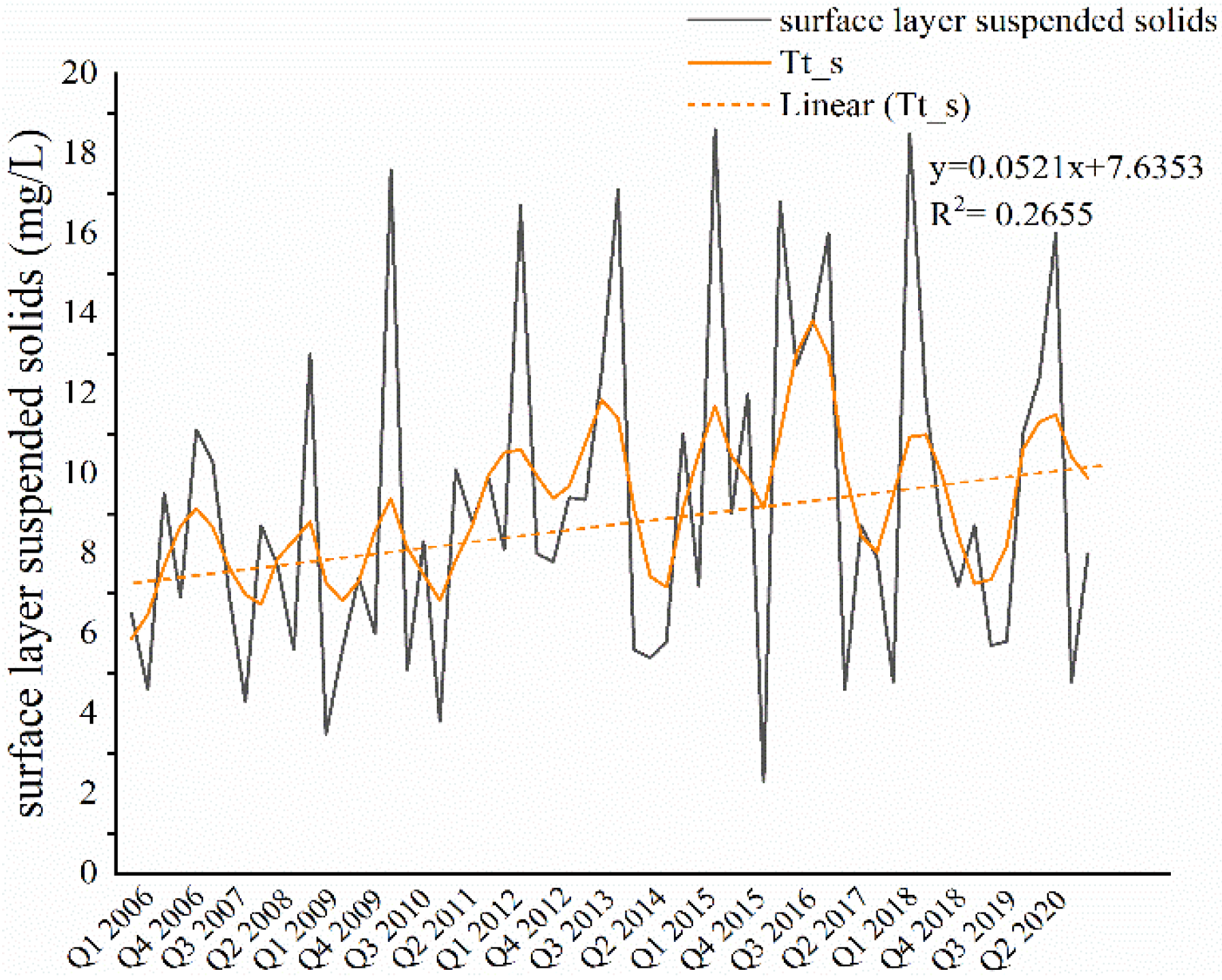
3. Results and Discussion

The study centered on nine marine environmental monitoring points related to the Busan New Port dredging in Gadeokdo island, illustrating the baseline status and trends of suspended solids at each location (Table 3). Table 3 reveals notable trends in suspended solids concentrations at various marine monitoring points. The slope of the increasing trend indicates that the highest rate of increase in suspended solids per quarter was observed at New Port 1 (0.217 mg/L in the bottom layer) and New Port 2 (0.08 mg/L in the bottom layer). Other locations, such as Jinhae Bay 17 and Jinhae Bay 14, also showed moderate increasing trends in the surface layer (0.111 mg/L and 0.056 mg/L, respectively). Regarding changes in suspended solid concentrations before and during the construction period, New Port 1 exhibited the most significant increase (2.312 mg/L in the surface layer and 3.841 mg/L in the bottom layer), followed by New Port 2 (2.053 mg/L in the surface layer) and Jinhae Bay 17 (2.459 mg/L in the surface layer). These results suggest that semi-enclosed sea areas, particularly New Port 1 and 2, experienced the most substantial impact on suspended solids due to construction activities where water circulation is limited, leading to sediment accumulation and dispersion.
Among the points, Sinhang 1 (New port 1) recorded the highest average levels of suspended solids, with 13.99 mg/L in the surface layer and 16.57 mg/L in the bottom layer. Conversely, the lowest levels were found at the fishing ground of Jinhae Bay 14, with 5.72 mg/L in the surface layer and 6.19 mg/L in the bottom layer. There was no clear increasing trend in suspended solids at Jinhae Bay 19, and no statistically significant changes were observed in suspended solids due to port construction. The p-values for the suspended solids trends in both surface and bottom layers were above the 0.05 threshold, indicating no significant change. Suspended solids concentrations generally decreased with increasing distance from the Gadeokdo new port site. However, in enclosed sea areas such as Busan New Port and the adjacent Sinhang 1 and 2 points, located on the northern side of Busan New Port, the concentrations of suspended solids were higher. Typically, currents in the region between Geoje Island and Gadeok Island flow northeast toward the Gadeokdo strait (Figure 3). The observed increase in water velocity near Gadeokdo appears to correlate with changes in suspended solid concentrations. Therefore, it is believed that the fluctuations in suspended solids levels are significantly influenced by the local currents around these stations.
Examining the suspended solids at the Sinhang 2 (New port 2) point from 2006 to 2020, the average concentration in the surface layer was 9.18 mg/L, with a maximum of 18.6 mg/L and a minimum of 2.3 mg/L. In the bottom layer, the average concentration was 11.46 mg/L, with a maximum of 84.4 mg/L and a minimum of 3.3 mg/L (Figure 4). To evaluate whether suspended solids levels increased during the intensive development phase in Shinhang 2, a comparative analysis was conducted for the periods before and after 2012. Statistical testing (t-test) revealed a significant change (p < 0.05) in the quantity of suspended solids in the surface layer. The environmental conditions at the Sinhang 2 point are comparable to those at Busan New Port and Sinhang 1, as all are located in confined areas, particularly near the entrance of an enclosed zone.
For suspended solids at Jinhae Bay 14 from 2010 to 2020, the average concentration in the surface layer was 5.72 mg/L. The highest concentration was recorded in the first quarter of 2017 at 22.20 mg/L, while the lowest was observed in the third quarter of 2017 at 1.20 mg/L. In the bottom layer, the average concentration was 6.19 mg/L, with a maximum of 19.67 mg/L in the first quarter of 2017 and a minimum of 1.55 mg/L in the third quarter of 2010. Based on the analysis of the time series characteristics of suspended solids data, the trends and extent of the impact of the new port construction are depicted in Figure 5.
The analysis of seasonal and trend-based time-series data on suspended solids yielded the following findings. Unlike Jinhae Bay 01, which did not show a significant upward trend in suspended solids in the lower layer from 2010 to 2020, a notable increase was observed in the upper layer. Specifically, the concentration of suspended solids in the upper layer increased by an average of 5.6% per quarter compared to the previous year.
To evaluate the impact of intensive dredging operations at the New Port since 2014, a comparison was made between suspended solid concentration from 2005 to 2013 and from 2014 to 2020. While no significant change was detected in the lower layer, the upper layer showed a significant average increase of 1.98 mg/L after 2014.
The statistical analysis revealed a significant upward trend in suspended suspended solids in the upper layers of Jinhae Bay 14 and Jinhae Bay 17, with average increases of 1.982 mg/L and 2.459 mg/L, respectively, since 2014. Prior to 2014, Jinhae Bay 1 exhibited a significant increase in both the upper and lower layers. After 12 years, there was a significant increase in the upper layer of Shinhang 2 and the lower layer of Jinhae Bay 01.
To assess the impact of dredging operations on marine water quality, we analyzed the Water Quality Index (WQI) environmental factors at each station and their correlations with suspended suspended solids levels.
The analysis focused on the following environmental factors to calculate the Water Quality Index (WQI): surface chlorophyll-a (Chl-a) concentration, subsurface dissolved oxygen (DO) saturation (%), surface dissolved inorganic nitrogen (DIN) levels, surface dissolved inorganic phosphorus (DIP) levels, and water transparency (Table 4).
Among the WQI factors, chlorophyll-a (Chl-a) levels were highest at Jinhae Bay 01 (average of 9.82 µg/L) and lowest at Jinhae Bay 14 (average of 3.2 µg/L). The fishing ground at Jinhae Bay 01 is situated near the dredged area of Busan New Port, where coastal water quality may be impacted by waste generated during the port’s construction. The ecosystem of this fishing ground primarily consists of shellfish and pearl oysters. However, the water quality, particularly in terms of chlorophyll-a levels and bottom-layer dissolved oxygen saturation (average 87.86%), falls below the standards established for regional water quality assessment indices (Table 5) [30]. In Jinhae Bay 17 the average Chl-a concentration and the DO saturation in the bottom layer do not meet the water quality assessment index standards for the area. This increase is directly related to the rise in Chl-a concentration in the surface layer, suggesting that the construction of the port has influenced the increase in Chl-a concentration in this fishery area through the generation of suspended solids. The average dissolved oxygen saturation percentage was highest at Sinhang 2 (98.5%) and lowest at Jinhae Bay 14 (66.48%) and Jinhae Bay 17 (66.21%).
The highest levels of dissolved inorganic nitrogen and dissolved inorganic phosphate were recorded at Sinhang 1, with average concentrations of 182.43 µg/L and 18.18 µg/L, respectively. In contrast, fishery grounds generally had much lower concentrations, ranging from 0.01 to 0.05 µg/L. Transparency measurements were highest at Jinhae Bay 14, reaching 7.21 m, while in enclosed areas, transparency typically ranged from 1.4 to 1.9 m.
The Water Quality Index (WQI), calculated by integrating five environmental factors related to marine water quality, averaged between 1 and 3 in areas associated with the dredging operations. The WQI at New Port 2 averaged a grade of 2.3 on a scale of 1 to 5, where 1 represents the highest quality and 5 is the lowest. Jinhae Bay 19 had the highest WQI, while enclosed areas had WQI values ranging from 2 to 3. The lowest WQI was observed at Jinhae Bay 14, primarily due to the relatively low levels of dissolved oxygen saturation in the water.
The significant relationships between suspended solids and WQI environmental factors are summarized in Table 6 as follows.
The correlation analysis revealed that suspended solids had significant relationships with various environmental factors, as detailed in the accompanying Table 6. Specifically, in Jinhae Bay 19 and Jinhae Bay 17, there were positive correlations between suspended solids and chlorophyll-a (Chl-a), with correlation coefficients of r = 0.804 and r = 0.619, respectively. Conversely, in Jinhae Bay 01, Jinhae Bay 17, and Jinhae Bay 19, significant negative correlations were found between suspended solids and transparency. Additionally, significant correlations were observed between suspended solids and dissolved oxygen saturation in Jinhae Bay 01 and Jinhae Bay 1.
Due to the complexity of analyzing causal relationships in time series data using correlation analysis, we employed time series regression modeling to investigate whether suspended solids directly contribute to the eutrophication of coastal waters. A time series analysis was performed to investigate the relationship between chlorophyll-a levels, suspended solids, and other water quality index (WQI) components, with a focus on their direct influence on marine ecosystems. Given the seasonality and non-stationary nature of the time series data, separate differencing was applied to address both seasonality and trends using a Multiplicative Seasonal ARIMA (Autoregressive Integrated Moving Average) approach. Various time series models were estimated for each sampling location, generally resulting in a simple ARIMA model (Table 7). In Table 8, the p-value obtained from the Ljung-Box Q test is greater than 0.05, indicating that the derived model is statistically adequate. A high p-value (greater than 0.05) suggests no significant autocorrelation [31], meaning the model’s residuals appear to be random. Ljung-Box Q test suggests that the residuals of the Chlorophyll A model do not show significant autocorrelation, indicating a good model fit in terms of capturing time-dependent patterns.
The ARIMA models are used to predict water quality parameters in Jinhae Bay, and the results suggest that the models perform reasonably well, especially for Jinhae Bay 19. The inclusion of lagged variables (e.g., t − 3) indicates that past values of certain parameters (like Chl-a and DIN) have a significant influence on current values. This highlights the importance of considering historical data when analyzing water quality trends. The absence of certain variables (e.g., DIP, bottom layer suspended solids) in some models suggests that these variables may not be significant predictors for those specific locations.
The analysis identified several locations where suspended solids significantly predicted coastal eutrophication, including Jinhae Bay 01, Jinhae Bay 17, and Jinhae Bay 19. In all three locations, surface layer suspended solids have a positive coefficient, indicating that higher suspended solids levels are associated with higher Chl-a concentrations. This suggests that suspended solids may contribute to eutrophication by promoting the growth of phytoplankton. In these areas, increased suspended solids were associated with higher levels of Chl-a. In Jinhae Bay 17, the relationship between chlorophyll-a (Chl-a) and suspended solids was analyzed using an ARIMA (0,0,0) (1,0,0) model, yielding a significant positive coefficient (0.404) for the suspended solids in the surface layer. The chlorophyll-a concentration in the surface layer was modeled using a multiplicative seasonal ARIMA approach with parameters ARIMA (0,0,0) (0,0,0). In Jinhae Bay 19, analysis of the relationship between chlorophyll-a and suspended solids using ARIMA revealed a significant positive coefficient for surface suspended solids (0.310). A strong relationship between overall suspended solids and chlorophyll-a levels was identified. This finding emphasizes the potential role of suspended solids as a precursor or driver of chlorophyll-a concentration dynamics in marine ecosystems. It highlights the importance of examining not only the current conditions but also the historical trends and interactions among environmental factors. Jinhae-1 sampling site is situated near the coastal area of the recently dredged Busan New Port, where dredging activities may have medium- to long-term impacts. Due to its connection with the marine conditions of key fishing grounds, this site is considered critical and warrants targeted management efforts. Overall, Table 7 demonstrates that suspended solids are a significant predictor of Chl-a concentrations, and their impact can be effectively modeled using time-series analysis techniques like ARIMA. This underscores the importance of monitoring and managing suspended solids to mitigate eutrophication in coastal waters. The models consistently show a positive relationship between suspended solids and chlorophyll-a levels, suggesting that suspended solids contribute to eutrophication in coastal waters. All models have high R² values, low RMSE, and low MAPE, indicating that they are effective in explaining the relationship between suspended solids and chlorophyll-a. The Ljung-Box Q statistics confirm that the residuals are free from autocorrelation, further validating the models.
Maslukah et al. (2022) studied water quality on Barrang Caddi Island and concluded that chlorophyll-a concentration is influenced by various water quality parameters, with total suspended solids (TSS) having the most significant positive impact [32]. Their findings revealed a positive correlation between chlorophyll-a and TSS, indicating that higher TSS levels are associated with increased chlorophyll-a concentrations. Gupta (2014) highlighted that chlorophyll-a concentration serves as an indicator of eutrophication levels and reflects nutrient availability in the water, making it a valuable tool for measuring water quality [33]. Li and Liu (2019) further emphasized that chlorophyll-a levels in water reflect the impact of various factors, particularly those resulting from human activities [34]. Therefore, the earlier research findings corroborate our observation regarding the positive correlation between the increase in suspended solids concentration and Chl-a.
To manage suspended solids in water during new port construction, it is essential to implement comprehensive monitoring and mitigation strategies. The study highlights that dredging and construction activities significantly increase suspended solid concentrations, which can lead to reduced water clarity, eutrophication, and ecological damage. To address this, construction practices should minimize sediment disturbance by using silt curtains or barriers to contain suspended solids and prevent their spread. Additionally, dredging operations should be carefully planned to avoid peak tidal currents and minimize resuspension of sediments. Regular monitoring of water quality parameters, such as suspended solids, chlorophyll-a, dissolved oxygen, and transparency, is crucial to assess the environmental impact and adjust construction practices accordingly. Advanced modeling techniques, like ARIMA, can be employed to predict and analyze the temporal dynamics of suspended solids, enabling proactive management. Finally, adopting sustainable construction methods and adhering to environmental guidelines will help mitigate the long-term impacts of suspended solids on marine ecosystems.

4. Conclusions

In this study, both surface and bottom waters exhibited suspended solid concentrations exceeding 10 mg/L. The analysis revealed significant increases in suspended solids concentration, particularly in the upper layers of Jinhae Bay, following the commencement of dredging operations at Busan New Port. Analyzing 17 years of water quality data, the study reveals significant increases in suspended solids concentration up to 92 mg/L in some areas correlating with construction activities. High concentrations of suspended solids were observed near the port site, with notable impacts on water quality parameters such as dissolved oxygen saturation and transparency which can disrupt marine ecosystems. The study found positive correlations between suspended solids and chlorophyll-a levels in certain areas, indicating potential eutrophication. Utilizing the ARIMA model, the research highlighted the need for long-term, seasonally adjusted monitoring of water quality to fully understand and mitigate the environmental impacts of such large-scale construction projects. Overall, we have proposed a straightforward quantitative analysis method to assess marine environmental changes caused by large-scale marine construction projects, utilizing big data collected from government operated ocean monitoring networks. Future research will focus on developing methodologies to predict changes in suspended solids and other marine environmental factors through multivariate statistical analysis and machine learning techniques.

Author Contributions

Conceptualization, J.K.; methodology, J.K.; software, J.K. and A.G.; validation, J.K.; formal analysis, A.G. and J.K.; investigation, J.K. and S.P.; resources, J.-J.Y. and S.P.; data curation, J.K.; writing—original draft preparation, A.G.; writing—review and editing, A.G. and T.P.; visualization, A.G. and J.K.; supervision, S.P.; project administration, J.-J.Y. and S.P; funding acquisition, J.-J.Y. and S.P. All authors have read and agreed to the published version of the manuscript.

Funding

This work was supported by a National Research Foundation of Korea (NRF) grant funded by the Korean government (MSIT) (2021R1I1A3060770) and the Basic Science Research Program through the National Research Foundation of Korea (NRF) funded by the Ministry of Education (2016R1A6A1A03012812). Also, this work was supported by the Dong-A University Foundation Grant in 2023.

Data Availability Statement

The data that support the findings of this study are available on request from the corresponding author.

Conflicts of Interest

Author Jaebum Kim was employed by the company Joons Engineering Co., Ltd. The remaining authors declare that the research was conducted in the absence of any commercial or financial relationships that could be construed as a potential conflict of interest.

References

  1. UNCTAD. World Investment Report 2019: Special Economic Zones; United Nations: New York, NY, USA; Geneva, Switzerland, 2019; pp. 126–206. [Google Scholar]
  2. Viatte, C.; Clerbaux, C.; Maes, C.; Daniel, P.; Garello, R.; Safieddine, S.; Ardhuin, F. Air pollution and sea pollution seen from space. Surv. Geophys. 2020, 41, 1583–1609. [Google Scholar] [CrossRef]
  3. IMO. International Maritime Organization Maritime Knowledge Centre. International Shipping and World Trade Facts and Figures. October 2009; pp. 1–37. Available online: https://seors.unfccc.int/applications/seors/attachments/get_attachment?code=P3NL79DO7SC1VMXXTMI8WYF2EFRAQN19 (accessed on 10 March 2025).
  4. Pásková, M.; Štekerová, K.; Zanker, M.; Lasisi, T.T.; Zelenka, J. Water pollution generated by tourism: Review of system dynamics models. Heliyon 2024, 10, e23824. [Google Scholar] [CrossRef] [PubMed]
  5. Stern, M.A.; Flint, L.E.; Flint, A.L.; Knowles, N.; Wright, S.A. The future of sediment transport and streamflow under a changing climate and the implications for long-term resilience of the San Francisco Bay-Delta. Water Resour. Res. 2020, 56, e2019WR026245. [Google Scholar] [CrossRef]
  6. Shaikh, S.M.S.; Tagde, J.P.; Singh, P.R.; Dutta, S.; Sangolkar, L.N.; Kumar, M.S. Impact of port and harbour activities on plankton distribution and dynamics: A multivariate approach. Mar. Pollut. Bull. 2021, 165, 112105. [Google Scholar] [CrossRef]
  7. Le Moal, M.; Gascuel-Odoux, C.; Ménesguen, A.; Souchon, Y.; Étrillard, C.; Levain, A.; Moatar, F.; Pannard, A.; Souchu, P.; Lefebvre, A.; et al. Eutrophication: A new wine in an old bottle? Sci. Total Environ. 2019, 651, 1–11. [Google Scholar] [CrossRef]
  8. Ménesguen, A.; Lacroix, G. Modelling the marine eutrophication: A review. Sci. Total Environ. 2018, 636, 339–354. [Google Scholar] [CrossRef]
  9. Jung, J.H.; Takdaeho; Lim, J.; Lee, D. Analysis of the current status and improvement plan for the assessment of suspended sediment dispersion impact. J. Korean Soc. Mar. Environ. Energy 2017, 20, 160–171. [Google Scholar] [CrossRef]
  10. Bilotta, G.S.; Brazier, R.E. Understanding the influence of suspended solids on water quality and aquatic biota. Water Res. 2008, 42, 2849–2861. [Google Scholar] [CrossRef]
  11. Liu, H.; Li, Q.; Shi, T.; Hu, S.; Wu, G.; Zhou, Q. Application of Sentinel 2 MSI images to retrieve suspended particulate matter concentrations in Poyang Lake. Remote Sens. 2017, 9, 761. [Google Scholar] [CrossRef]
  12. Lyu, Y.; Zhao, W.; Kinouchi, T.; Nagano, T.; Tanaka, S. Development of statistical regression and artificial neural network models for estimating nitrogen, phosphorus, COD, and suspended solid concentrations in eutrophic rivers using UV–Vis spectroscopy. Environ. Monit. Assess. 2023, 195, 1114. [Google Scholar] [CrossRef]
  13. He, Q.; Qiu, Y.; Liu, H.; Sun, X.; Kang, L.; Cao, L. New insights into the impacts of suspended particulate matter on phytoplankton density in a tributary of the Three Gorges Reservoir, China. Sci. Rep. 2017, 7, 13518. [Google Scholar] [CrossRef] [PubMed]
  14. Jung, T.S.; Kim, T.S.; Kang, S.W. A prediction system of suspended solids induced by dredging. J. Korean Soc. Coast. Ocean Eng. 2004, 16, 47–55. [Google Scholar]
  15. Jung, T.S. A method for improvement of tide and tidal current prediction accuracy. J. Korean Soc. Mar. Environ. Energy 2010, 13, 234–240. [Google Scholar]
  16. Tac, D.H.; Lee, D.I.; Seo, J.B.; Lee, D.G.; Jung, B.G. Simulation of suspended sediments dispersion from small-scale river to sea with particle tracking method. J. Korean Soc. Environ. Technol. 2015, 16, 441–448. [Google Scholar]
  17. Choo, T.H.; Kim, Y.H.; Park, B.S.; Kwon, J.W.; Cho, H.M. Proposal for estimation method of the suspended solid concentration in EIA. J. Wetl. Res. 2017, 19, 30–36. [Google Scholar] [CrossRef]
  18. Kim, B.S. A Study on the Water Quality Characteristics of the Surrounding Waters Due to the Construction of Busan New Port. Master’s Thesis, Pukyong National University, Busan, Republic of Korea, 2011. [Google Scholar]
  19. Yudhistira, M.H.; Karimah, I.D.; Maghfira, N.R. The effect of port development on coastal water quality: Evidence of eutrophication states in Indonesia. Ecol. Econ. 2022, 196, 107415. [Google Scholar] [CrossRef]
  20. Kim, D.; Baek, S.H.; Yoon, D.Y.; Kim, K.H.; Jeong, J.H.; Jang, P.G.; Kim, Y.O. Water quality assessment at Jinhae Bay and Gwangyang Bay, South Korea. Ocean Sci. J. 2014, 49, 251–264. [Google Scholar] [CrossRef]
  21. Park, Y.N. A Study on the Characteristics of Water Quality in the Jinhae Bay. Master’s Thesis, Korea Maritime University, Busan, Republic of Korea, 2004. [Google Scholar]
  22. Malik, D.S.; Sharma, A.K.; Sharma, A.K.; Thakur, R.; Sharma, M. A review on impact of water pollution on freshwater fish species and their aquatic environment. Adv. Environ. Pollut. Manag. 2020, 1, 10–28. [Google Scholar]
  23. National Park Research Institute. 2016 Taean Coastal National Park Marine Environment Change Monitoring Network; National Park Research Institute: Taean, Republic of Korea, 2019. [Google Scholar]
  24. Wang, S.; Feng, J.; Liu, G. Application of seasonal time series model in the precipitation forecast. Math. Comput. Model. 2013, 58, 677–683. [Google Scholar] [CrossRef]
  25. Shehhi, M.R.A.; Kaya, A. Time series and machine learning to forecast the water quality from satellite data. arXiv 2020, arXiv:2003.11923. [Google Scholar]
  26. Stuart, E.A.; Azur, M.; Frangakis, C.; Leaf, P. Multiple imputation with large data sets: A case study of the Children’s Mental Health Initiative. Am. J. Epidemiol. 2009, 169, 1133–1139. [Google Scholar] [CrossRef] [PubMed]
  27. Monteiro, M.; Costa, M. A time series model comparison for monitoring and forecasting water quality variables. Hydrology. 2018, 5, 37. [Google Scholar] [CrossRef]
  28. Abaurrea, J.; Asín, J.; Cebrián, A.C.; García-Vera, M.A. Trend analysis of water quality series based on regression models with correlated errors. J. Hydrol. 2011, 400, 341–352. [Google Scholar] [CrossRef]
  29. Rho, T.K.; Lee, T.S.; Lee, S.R.; Choi, M.S.; Park, C.; Lee, J.H.; Lee, J.Y.; Kim, S.S. Reference values and water quality assessment based on the regional environmental characteristics. J. Korean Soc. Oceanogr. 2012, 17, 45–58. [Google Scholar]
  30. Park, M.O.; Lee, Y.W.; Park, J.K.; Kang, C.S.; Kim, S.G.; Kim, S.S.; Lee, S.M. Evaluation of the seawater quality in the coastal area of Korea in 2013–2017. J. Korean Soc. Mar. Environ. Energy 2019, 22, 47–56. [Google Scholar] [CrossRef]
  31. Hassani, H.; Yeganegi, M.R. Sum of squared ACF and the Ljung-Box statistics. Physica A. 2019, 520, 81–86. [Google Scholar] [CrossRef]
  32. Maslukah, L.; Setiawan, R.Y.; Nurdin, N.; Helmi, M.; Widiaratih, R. Phytoplankton chlorophyll-a biomass and the relationship with water quality in Barrang Caddi, Spermonde, Indonesia. Ecol. Eng. Environ. Technol. 2022, 23, 1–8. [Google Scholar] [CrossRef]
  33. Gupta, M. A new trophic state index for lagoons. J. Ecosyst. 2014, 2014, 152473. [Google Scholar] [CrossRef]
  34. Li, D.; Liu, S. Water Quality Monitoring and Management: Basic, Technology, and Case Studies; Academic Press: London, UK, 2019; p. 362. [Google Scholar]
Figure 1. Basic model of research project.
Water 17 00852 g001
Figure 2. Marine environmental observation points related to Busan New Port construction located in Seongbuk neighbourhood, Gangseo district, Busan, Republic of Korea (* indicates aquaculture environment monitoring points).
Water 17 00852 g002
Figure 3. Pictorial representation of the direction of tidal currents in Jinhae bay.
Water 17 00852 g003
Figure 4. Trend of suspended solids in the surface layer of Shinhang 2 (black line indicates raw data, orange indicates the trend line).
Water 17 00852 g004
Figure 5. Trend of suspended solids in the surface layer of Jinhae Bay 14 (black line indicates raw data, orange indicates trend line).
Water 17 00852 g005
Table 1. Details about the construction phases of Busan New Port.
Project NameProject DetailsDurationProject Cost (KRW)
BreakwaterBreakwater 1.49 km, Working Pier 600 mOct 1997–Dec 2002127.5 billion
Dredged Soil Disposal Site Phase 1Revetment 9004 km, Breakwater 230 m, Bridge 930 m, Road 2686 mMay 2000–Nov 2004263.5 billion
Dredged Soil Disposal Site Phase 2Revetment 7399 m, Road 225 mSep 1999–Dec 2004245.8 billion
Connecting Pier & Multipurpose WharfConnecting Pier 300 m, Multipurpose Wharf 400 mDec 2002–Mar 200786.2 billion
Southern ’Container’ Wharf LowerBerth 1150 m (4 berths, Depth (−)17 m)Dec 2004–Apr 2009251.4 billion
Multipurpose Wharf HinterlandLand Development 177,000 m2, Road 1.2 kmJul 2004–May 200965.3 billion
Southern ’Container’ Wharf HinterlandRevetment 4.6 kmDec 2005–Dec 2011110.8 billion
Woongdong Disposal Site ElevationDisposal Site Elevation 1.5 mMay 2010–Apr 20112.7 billion
Channel Dredging Phase 1Channel Dredging 60 million m3 (including 92,000 m3 of rock dredging)Oct 2003–Jul 2011183.3 billion
Breakwater ReinforcementBreakwater Reinforcement 12.7 kmJul 2009–Jul 201369.2 billion
Woongdong Dredged Soil Disposal SiteRevetment 163.4 km, Woongcheon Bridge 9.3 km1999–Nov 2004522.8 billion
Western ’Container’ Dredged Soil Disposal SiteRevetment 2485 m, Linked Embankment 486 mDec 2009–Jun 201290.6 billion
Songdo Dredged Soil Disposal SiteOuter Revetment 810 m, Inner Revetment 11.9 km, Separation Revetment 650 mJun 2012–Apr 2015123.1 billion
Depth Restoration Phase 1Dredging 2.43 million m3Sep 2012–Jan 201310.6 billion
Depth Restoration Phase 2Dredging 2.05 million m3Sep 2012–Apr 201411.3 billion
Earth island Removal ProjectEarth island Removal Work 1 caseNov 2017–Apr 2020303.1 billion
New Dredged Soil Disposal Site Revetment ConstructionRevetment 1.6 km ConstructionFeb 2017–Jun 2020303.1 billion
Table 2. Data category and collection location for the busan new port construction.
LocationCategoryStart DateTypeRemarks
Busan New Port 1Port monitoring networkAugust 2004Semi-annual (February, August)To ensure semi-annual timing, data from February 2005 is used.
New Port 1Semi-enclosed sea areaFebruary 2006Quarter (February, May, August, November)
New Port 2Semi-enclosed sea areaFebruary 2006Quarter (February, May, August, November)
Jinhae Bay 1Semi-enclosed sea areaFebruary 1999Quarter (February, May, August, November)Due to missing values, data from February 2005 was used.
Masan Bay 8Semi-enclosed sea areaFebruary 2009Quarter (February, May, August, November)
Jinhae Bay 01Aquaculture environmentFebruary 2009Quarter (February, May, August, November)
Jinhae Bay 14Aquaculture environmentFebruary 2009Quarter (February, May, August, November)
Jinhae Bay 17Aquaculture environmentFebruary 2009Quarter (February, May, August, November)
Jinhae Bay 19Aquaculture environmentFebruary 2009Quarter (February, May, August, November)
Table 3. Trends in the suspended solids concentration at different marine environmental monitoring points.
NoSea Area/
Sampling Point
DivisionSurface Layer Suspended Solids
(mg/L)
Bottom Layer Suspended Solids
(mg/L)
Slope of Increasing Trend *
(mg/L/Quarter)
Change of Suspended Solids After Construction **
(mg/L)
AverageMaxAverageMaxSurface LayerBottom LayerSurface LayerBottom Layer
1Busan New Port 1Port monitoring network11.723015.853.8_0.49__
2New Port 1Semi-enclosed sea area13.9975.216.5792.60.1170.2172.3123.841
3New Port 2Semi-enclosed sea area9.1818.611.4684.40.0520.082.053_
4Jinhae Bay 01Aquaculture environment8.8332.39.0619.45_0.047__
5Jinhae Bay 14Aquaculture environment5.7222.26.1925.20.056_1.982_
6Jinhae Bay 19Aquaculture environment7.8634.97.6330.9____
7Jinhae Bay 17Aquaculture environment7.1936.76.19220.111_2.459_
8Masan Bay 8Semi-enclosed sea area7.123.712.7735.9____
9Jinhae Bay 1Semi-enclosed sea area7.2827.111.5638.9_0.105_1.875
Notes: * ‘slope’ represents the rate of change per quarter (3 months). ** change in average suspended solid concentration before and during the construction period.
Table 4. Water quality index analysis based on environmental factors (DO, Chl-a, DIN, DIP, transparency).
Sea AreaChl-a Level (µg/L)DO (%)DIN (mg/L)DIP (mg/L)Transparency (m)WQI
AverageMaxst devAverageMinst devAverageMaxst devAverageMaxst devAverageMinst devAverageMax2019
Busan New Port 14.5527.581.5595.357.331.77125.76398.41.2613.38341.191.530.83.92.8112
New Port 13.2375.21.2592.4257.91.68182.431094.31.418.1840.71.51.420.44.082.6312
New Port 24.9322.391.798.570.111.37100.39220.4112.7131.81.181.850.83.282.3312
Jinhae Bay 019.8284.451.6887.8651.762.510.10.3210.0130.0413.130.62.162.8312
Jinhae Bay 143.219.671.2766.486.532.960.0490.210.0110.0417.212.51.043.0212
Jinhae Bay 193.4211.211.1991.9431.641.710.0450.1710.0110.0315.83311.7611
Jinhae Bay 174.3520.761.4974.296.212.510.0390.2110.00830.0416.241.51.12.6511
Masan Bay 85.9146.91.5386.4442.312.0361.74343.41.098.12291.063.611.51.412.3513
Jinhae Bay 14.7626.551.5392.2853.341.6476.543531.0911.11361.173.140.91.672.0912
Table 5. Standard values of water quality index parameters for Korea Strait.
Surface Chl-aBottom DO
(Saturation %)
Surface DIN
(µg/L)
Surface DIP
(µg/L)
Secchi Depth
(m)
6.390220352.5
Table 6. Analysis of the significant relationships between suspended solids and environmental factors of the Water Quality Index (WQI).
Sea Area/
Sampling Point
Correlation with Environmental Factors in Water Quality Assessment (Correlation with Suspended Solids)
Chl-a Surface LayerDO Bottom LayerDIN Surface LayerDIP Surface LayerTransparency
Busan New Port 1××−0.419××
New Port 1××0.262××
New Port 2×××××
Jinhae Bay 010.3220.339−0.39−0.389−0.416
Jinhae Bay 14×××××
Jinhae Bay 190.804×××−0.384
Jinhae Bay 170.619×××−0.569
Masan Bay 8×××××
Jinhae Bay 1×0.292 0.3×
Notes: The normality and non-normality of each time series data were assessed, and parametric correlation analysis was performed to analyze the respective results. ‘×’ represents that correlation wasn’t found to be statistically significant.
Table 7. Various time-series regression model analysis to assess the influence of suspended solids on eutrophication in coastal areas.
Sea Area Location/
Sampling Point
ModelExplanatory Variables
Chl-a (Surface Layer)DO (Bottom Layer)DIN (Surface layer)DIP (Surface Layer)Surface Layer Suspended SolidsBottom Layer Suspended Solids
Jinhae Bay 01ARIMA (0,0,1) (0,0,0)1.481(t − 3)__0.703_
Jinhae Bay 19ARIMA (0,0,0) (0,0,0)−0.47915.173(t−3)_0.310_
Jinhae Bay 17ARIMA (0,0,0) (1,0,0)___0.404_
Note: ‘_’ = not statistically significant
Table 8. Evaluation the model’s effectiveness based on Ljung–Box statistics, R2, RMSE, and MAPE%.
ModelLjung–Box Q p-Value: 18 LagsR2RMSEMAPE%
ARIMA (0,0,1) (0,0,0)0.8970.7840.07851.54
ARIMA (0,0,0) (0,0,0)0.6540.8640.01170.91
ARIMA (0,0,0) (1,0,0)0.1030.8330.03340.55
Disclaimer/Publisher’s Note: The statements, opinions and data contained in all publications are solely those of the individual author(s) and contributor(s) and not of MDPI and/or the editor(s). MDPI and/or the editor(s) disclaim responsibility for any injury to people or property resulting from any ideas, methods, instructions or products referred to in the content.

