Article

Mineralogical and Chemical Characteristics of Sediments in the Lhasa River Basin: Implications for Weathering and Sediment Transport

1
School of Earth Sciences and Engineering, Hohai University, Nanjing 210098, China
2
Nanjing Institute of Environmental Sciences, Ministry of Ecology and Environment, Nanjing 210042, China
*
Authors to whom correspondence should be addressed.
These authors contributed equally to this work.
Water 2025, 17(4), 581; https://doi.org/10.3390/w17040581
Submission received: 2 January 2025 / Revised: 24 January 2025 / Accepted: 14 February 2025 / Published: 18 February 2025
(This article belongs to the Section Water Erosion and Sediment Transport)

Abstract

:
The Lhasa River, as one of the major rivers on the Tibetan Plateau, is of great value for the study of climate and environmental changes on the Tibetan Plateau. In this paper, the grain size and the mineralogical and geochemical characteristics of the sediments from the Lhasa River were investigated. The results show the following: (1) The average grain size of the Lhasa River sediments is coarse (65.5% sand, 23.6% silt), and the sorting is overall poor; the skewness is mostly positive, and the kurtosis is wide, which reflects the obvious characteristics of river sand deposition. (2) The mineral composition of the Lhasa River sediments is dominated by quartz (38.4%), feldspar, and plagioclase feldspar, followed by clay minerals, and the content of carbonate minerals is relatively low; the content of clay minerals in the illite content is as high as 83.3%, while the chlorite content is slightly higher than kaolinite, and smectite content is very low. The chemical index of illite is less than 0.4, indicating that illite is mainly iron-rich magnesium illite. (3) The value of the chemical weathering index (CIA) of the sediments is low, implying that the sediments are in a weak–moderate chemical weathering state and dominated by physical weathering. Comprehensive analyses further revealed that the weathering process of the sediments in the Lhasa River was influenced by both climate and lithology, i.e., sediment composition is influenced not only by chemical weathering in a dry, cold climate but also by physical weathering of granites exposed over large areas. The results of this study can provide scientific references for further in-depth research on the environmental and climatic effects of the Tibetan Plateau.

1. Introduction

The Tibetan Plateau is the highest and largest plateau in the world, and its uplift has had a significant impact on atmospheric and oceanic circulation in Asia, the formation of the monsoon, and even global climate change [1]. The products of plateau weathering and denudation are transported by rivers into the sea, which significantly alters the sedimentary regime of the Asian Marginal Seas and the fluxes of global ocean chemistry [2,3,4]. Because of this, a great deal of research has been carried out on the major rivers originating from the Tibetan Plateau [5,6,7]. The Yarlung Tsangpo River is an important river on the southern Tibetan Plateau, with a watershed area of up to 610,000 km2, covering almost the entire southern part of the plateau. The Himalayan orogenic belt is the region with the strongest tectonic and climatic interactions on the Tibetan Plateau and the most rapid geomorphologic evolution, which has now become a good field experiment site for the study of climate-tectonic interaction [8]. The study of the relationship between weathering and denudation of the Yarlung Tsangpo River with climate and tectonics has thus attracted widespread attention [9,10,11,12].
In recent years, as the study of small watersheds on the Tibetan Plateau increases year by year, many scholars have found that some small watersheds of the Yarlung Tsangpo River have unique characteristics different from those of the downstream sections or the main stream. For example, the lithology of the Yarlung Tsangpo River basin varies greatly from upstream to downstream. Zhang et al. [13] found that the bedrock type was the main reason for the lower correlation between CIA and Rb/Sr values in the Yigon Zangbo–Palong Zangbo river section than in other sections and the CIA values of these sediments are extremely low, which is attributed to the distribution of the ophiolite and ultra-K volcanic rocks in this area (upper reach). In contrast, the middle and lower reaches of the YTR have a large area of granite rocks, and their CIA values are higher. Li et al. [14] found that the rare earth distribution pattern at the source of the Yarlung Zangbo River was dramatically different from that of the downstream, which was thought to reflect the unique hydrological conditions of the local sub-watersheds. Since grain size influences the REE concentrations of the Yarlung Tsangbo River sediment significantly, Hasan et al. [15] found that the monomineral characterization of the sediments of the Brahmaputra River in Bangladesh indicates that the river sediments are mainly derived from the eastern Himalayan rivers. It has been shown that the conditions such as climate and subsurface of the Tibetan Plateau and the Yarlung Tsangpo River basin have changed significantly in recent decades [16,17,18]. Whether the influencing factors and patterns of chemical weathering in small watersheds in the Tibetan Plateau region have changed accordingly needs to be further explored [15].
The Lhasa River is the largest tributary of the Yarlung Tsangpo River basin in terms of area, which is more strongly affected by human activities than other tributaries, and its watershed geological conditions are complex. Previous studies have mostly focused on the hydrogeochemical characteristics and pollution of the Lhasa River. For example, Zhang et al. [18] found that human activities increased the input of nitrogen to the Lhasa River through nitrogen isotope analysis. Ning et al. [19] investigated the hydrogen and oxygen isotope composition characteristics of the Lhasa River water and analyzed the recharge sources of the river. Li et al. [20] found that glacial meltwater had an important impact on the hydrochemical characteristics of the Lhasa River. Mao et al. [21] pointed out that soil ion loss, climatic conditions, and environmental factors together influence the hydrochemical characteristics of the Lhasa River through the minimum cumulative resistance (MCR) model analysis. However, there are few discussions on the mineral composition and geochemical characteristics of the Lhasa River sediments, and little is known about the sediment origins, weathering and denudation processes, and their influencing factors within the watershed.
In this study, we systematically investigate the sediment grain size, mineralogy, and geochemistry of the Lhasa River and its two tributaries (Duilongqu and Wululongqu), and discuss the process of the source-sinking of the river sediment and its controlling factors. The results can provide scientific references for further in-depth study of the environmental climate effects on the Tibetan Plateau.

2. Materials and Methods
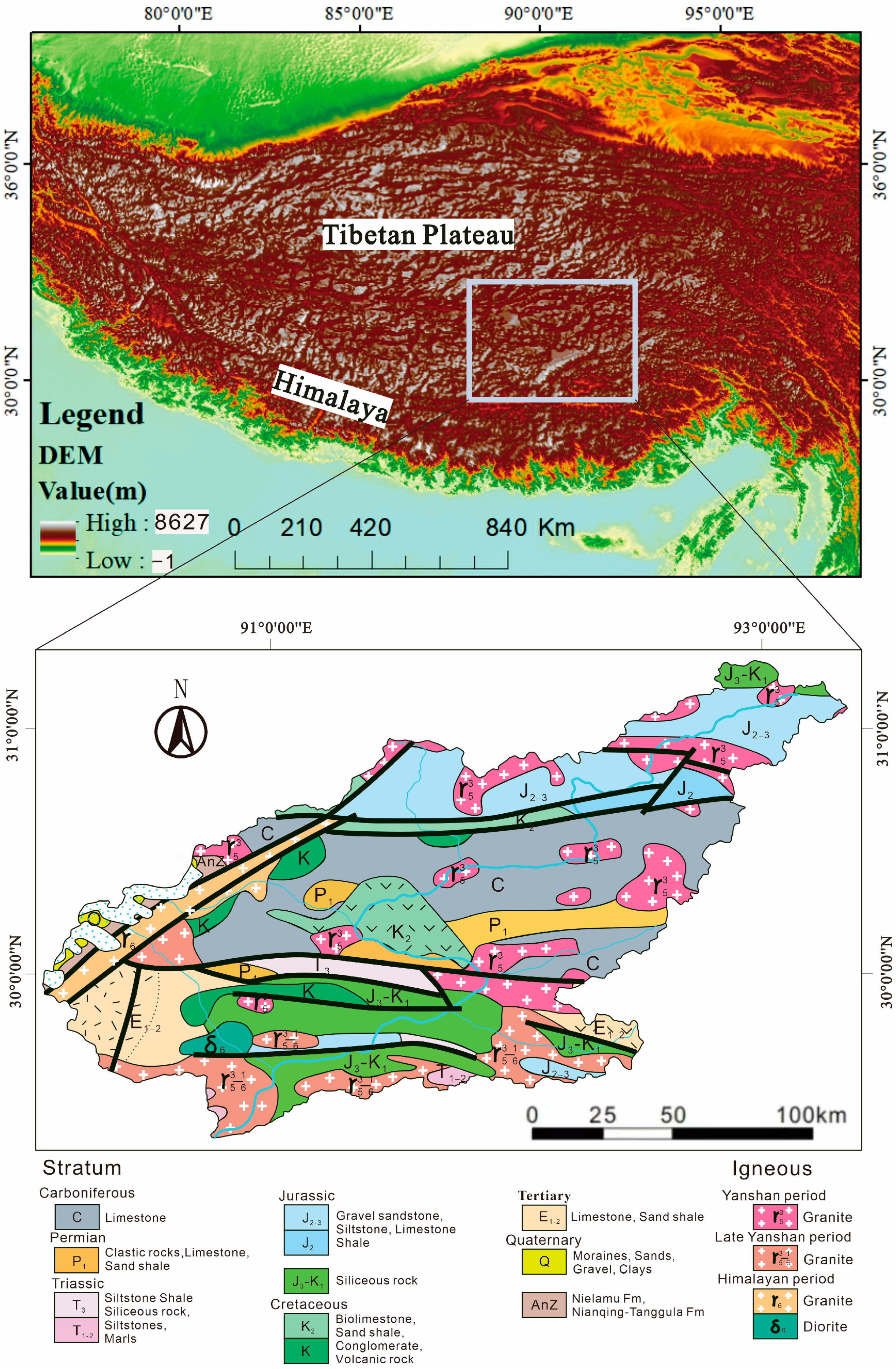
2.1. Study Area

The Lhasa River is located on the left bank of the middle reaches of the Yarlung Tsangpo River Basin in the Tibet Autonomous Region, originating in the Nyenchen Tanglha Mountain Range, with a total river length of 568 km (Figure 1). The main tributaries include Sangqu, Wululongqu, Xuerongzangbu, Mozhumaqu, and Duilongqu. The Lhasa River basin is characterized by a monsoon climate with distinct wet and dry seasons, which are from May to October and from November to April, respectively. River water is sourced mainly from precipitation, snow-melt water, and groundwater. The average annual precipitation in the Lhasa River basin is about 550 mm, mainly from June to September (accounting for 83.0% of the annual precipitation), decreasing from north to south. The average annual temperature is −1.28 °C, with the highest in June (12.4 °C) and the lowest in January (−5.7 °C), decreasing from south to north. The total annual runoff volume is 9.08 × 10⁹ m3, with a mean annual discharge of 287 m3/s at the Lhasa stations, and about 90% of the mean annual river discharge occurs during the warm season, which belongs to the snowmelt and rainfall type of river. The size of the runoff is mainly controlled by the precipitation, and the evaporation is large. The average altitude of the basin is above 3600 m, and the terrain is generally high in the northeast and low in the southwest. The climatic characteristics of the basin are cold and dry, with a large daily temperature difference and a small annual temperature difference. The headwaters and upstream areas of the Lhasa River are characterized by high altitudes, flat terrain, and the presence of plateau meadows. These areas are primarily used for animal husbandry and are sparsely populated. In the middle reaches of the Lhasa River, at an altitude of about 4000 m, shrubs begin to appear and are distributed along the valley area, but the vegetation of the mountains on both sides is still dominated by grassland. The lower reaches have open and flat river valleys, where agriculture is mainly developed, along with industrial and commercial activities [18].
The stratigraphic distribution in the basin is consistent with the strike of the fault zone, and there are all the strata from the Carboniferous to the Quaternary, with the Jurassic and Carboniferous dominating in the river section above Punto and the Cretaceous dominating below Punto (Figure 1). The thickness of the strata mostly exceeds 3000 m. The geological development history, sedimentation, metamorphism, and magmatic activity of each stratum varies greatly. Petrographic variations are complex, with greywacke and sand shale present in most of the strata, and moderately acidic volcaniclastic clasts prevalent in all strata in the middle and lower reaches of the river. Acidic–medium acidic rocks are widely exposed and distributed over a large area, mainly Yanshanian and late Yanshanian granite.

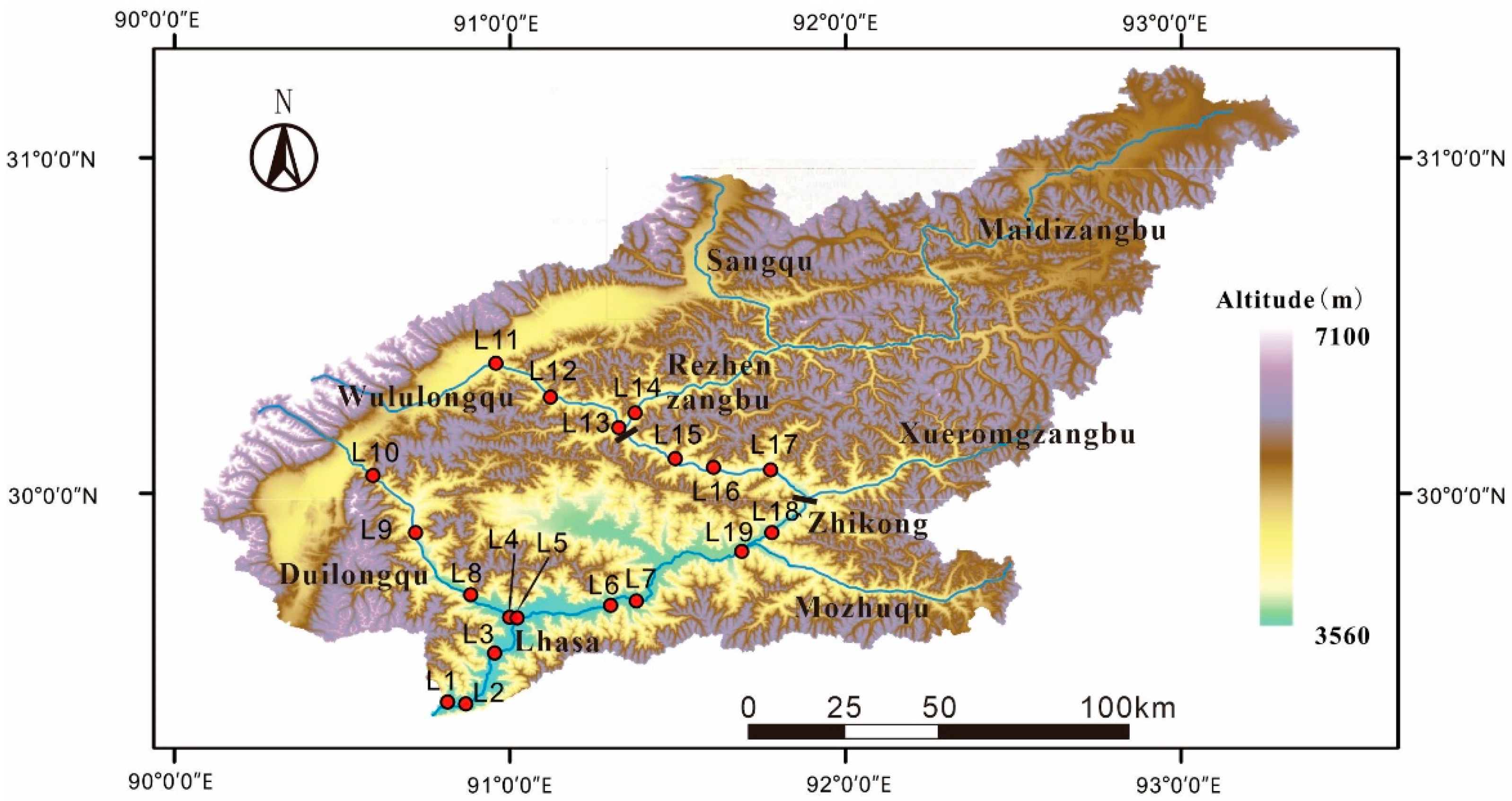
2.2. Sample Collection

In this study, a total of 19 sampling sites were set up in the main stream of the Lhasa River and two tributaries, Duilongqu and Wululongqu (Figure 2), of which 5 sites were in the middle reaches of the main stream and 8 sites were in the lower reaches. The six sampling sites in the tributaries of the Lhasa River included 2 in Wululongqu and 4 in Duilongqu. Surface sediment samples were collected, mixed well, and then placed in polythene bags cleaned with ultrapure water. For each sample, three 15 cm × 15 cm bank sampling points were randomly selected, and more than 1000 g samples were collected from a depth of 5–10 cm at each sampling point. Then, the samples from the three sampling points were well mixed into one sample (more than 3000 g) in the laboratory.

2.3. Grain Size Analysis

The grain size of the river sediment was tested on a Malvern Mastersizer 2000 (Malvern Panalytical, Malvern, UK) Laser instrument at the Institute of Surficial Geochemistry, Nanjing University. Each sample was measured three times, and the repeated measurement error was less than 3%. Based on the grain size data, the percentage content of different grain sizes of clay (<4 μm), silt (4~63 μm), sand (>63 μm~2000 μm), and gravel (>2000 μm) were counted, and the grain size parameters were calculated according to the method proposed by Folk and Ward [22], including the average particle size Mz (unit Φ), the sorting coefficient δ, the skewness SK, and the kurtosis coefficient KG.

2.4. Mineral Analysis

The mineralogy of the bulk samples (removing gravel) was determined by X-ray diffractometer. The instrumental test conditions were Cu target, voltage 40 kV, current 40 mA, step width 0.02°2θ, and scanning range of 3°~65°2θ.
The clay fraction was separated from the bulk samples based on Stokes’ Law, suspended in deionized water, and allowed to dry on glass slides to form oriented aggregates. Before XRD analysis, the clay fraction was dried naturally, saturated with ethylene glycol at 60 °C in ethylene glycol (EG) vapor for 12 h, heated at 550 °C for 2 h, and heated with 3 mol/L HCl at 80 °C for two hours. The oriented slices were then subjected to testing under the conditions of Cu target, voltage 40 kV, current 40 mA, and scanning range of 3°~36°2θ with a step width of 0.02°2θ. Semi-quantitative calculations of the clay minerals were mainly based on the areas of the X-ray diffraction peaks obtained under ethylene glycol treatment, multiplied by the weighting coefficients given by Biscaye [23].

2.5. Major Elements Analysis

The samples were soaked in 0.5 mol/L acetic acid for 24 h to remove the carbonate minerals, and then, X-ray fluorescence spectrometry (XRF) was used to determine the Major elements content of the sediments [24]. The 0.6 g sample was mixed with 6.6 g of the fluxing agent Li tetraborate and Li metaborate (Li2B4O7/LiBO2 = 67/33), and then, the mixed sample was added to a 120 mg/L LiBr flux in a platinum crucible before being measured by an X-ray fluorescence spectrometer. The content of major elements was expressed as oxide content, and the absolute errors were ± 0.5% and ± 0.2% for Si and Al, respectively. The relative errors for the other elements were less than 10%.

3. Results

3.1. Grain Size Composition

The results of the sediment grain size are shown in Table 1. The average content of sand is the highest, reaching 65.45%, which is mainly distributed in the middle reaches of Wululongqu, a tributary of the Lhasa River, and in the upper reaches of the Lhasa River. This is followed by silt and gravel, with an average content of 23.64% and 7.00%, respectively. The clay content is the lowest, only 3.91%. The average grain size (Mz), sorting coefficient (δ), skewness (SK), and peak state (KG) are the indicators of the mean, uniformity, and concentration of the sediments [25]. The mean grain size of sediments mainly ranges from –1.17 to 5.29 φ and is dominated by sand and silt (Table 1, Figure 3). Samples L13, L12, and L8 contain gravel, with L18 having the highest gravel content. Sorting coefficients range from about 0.50 to 2.99, with poor sorting, especially near the tributaries joining the mainstem. Sediments located upstream of Wululongqu (L11) have the highest sand content and the lowest silt content. The skewness coefficients mainly range from –0.11 to 0.60, with most of them showing positive and very positive skewness, indicating that most of the sediments are fine-grained. The kurtosis coefficients range from 0.80 to 3.70, with a mean value of 1.35. The distribution of kurtosis coefficients in the basin is heterogeneous, with wide or medium kurtosis near the estuary and medium or narrow kurtosis in the rest reach of the river (Figure 3).

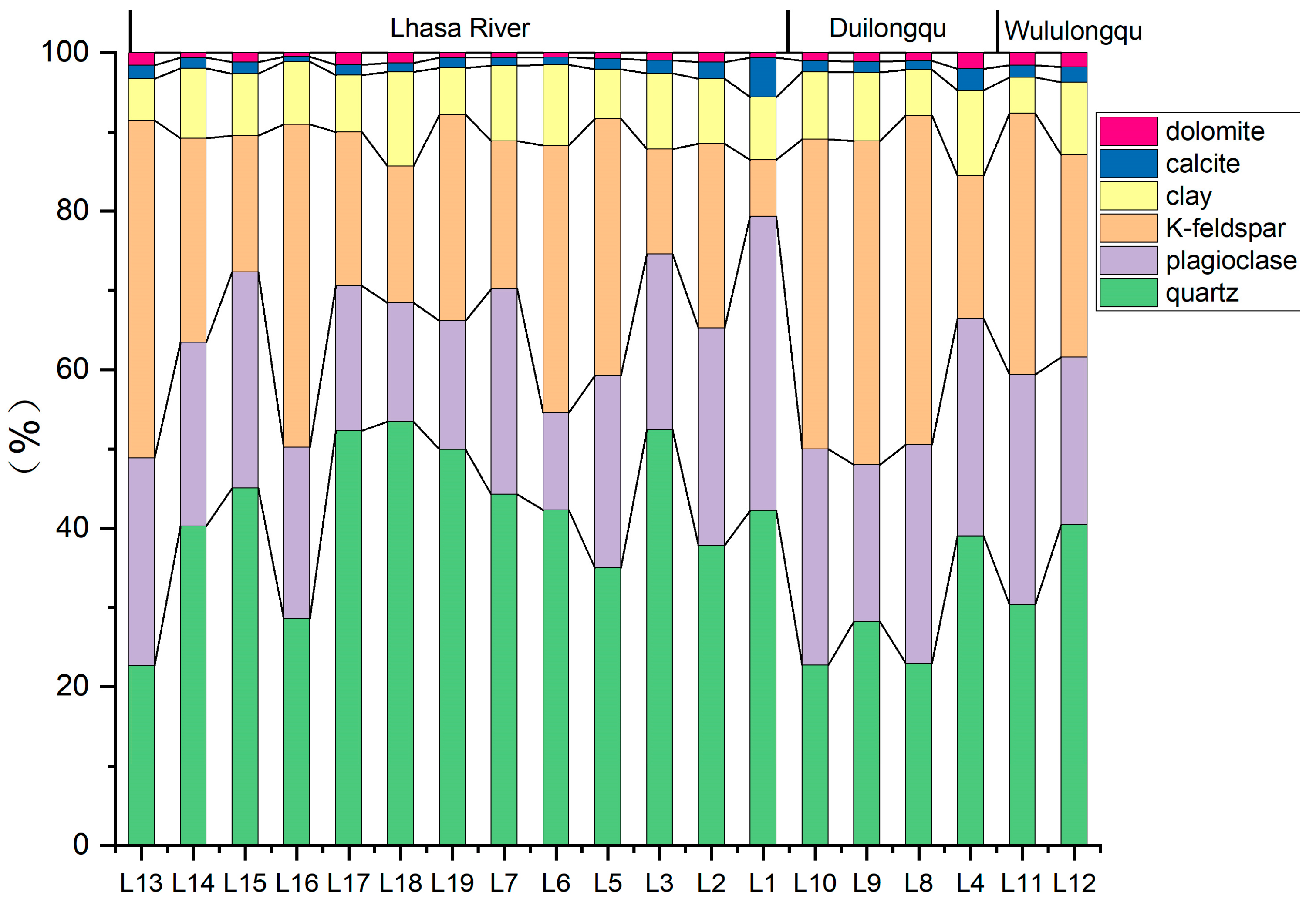
3.2. Mineral Composition

3.2.1. Mineralogy

Quartz and feldspar are the dominant minerals in the Lhasa River sediments. Clay minerals and carbonate minerals are minor components (Figure 4). Quartz, with an average content of 38.42%, is the most abundant mineral in the Lhasa River sediments, with L18 having the highest quartz content of 53.43%, which may have been influenced by the large outcrops of granite in the surrounding area (Figure 4). In addition, the feldspar content is also high, including plagioclase with an average value of 23.64%, with the highest distribution at the Yarlung Tsangpo River confluence (L1), where the content is as high as 37.11% (Figure 4). Potassium feldspar averages 27.11%, with the highest value of 42.57% occurring near L13. The feldspar content increases from the Zhikong (L17) to the Duilongdeqing section (L6), which may be related to the contribution of the Xuelongzangbu sediments (Figure 4). The carbonate mineral content in the Lhasa River basin is very low, with average contents of calcite and dolomite at 1.64 percent and 1.10 percent, respectively (Figure 4).

3.2.2. Clay Mineral Composition

Clay minerals were identified according to Mao et al. [24] by discriminating the basal diffraction peak positions of the (001) series facets of various clay minerals in the X-diffraction patterns of naturally air-dried and treated (ethylene glycol saturated, HCl treated, and heated at 550 °C). As shown in Figure 5, the 10 Å peak of illite was indicated by its unchanged position after ethylene glycol saturation, hydrochloric acid treatment, and heating at 550 °C. The characteristic 7 Å peak of kaolinite disappeared after heating at 550 °C but not after HCl treatment, indicating the presence of kaolinite. The presence of a broad peak of 12–15 Å for smectite, which increased to 17 Å (lower intensity) after saturation with ethylene glycol, indicated the presence of a small amount of smectite. The sample contains chlorite as indicated by the primary diffraction peak at 14 Å (001) and the tertiary diffraction peak at 4.7 Å (003), which disappeared after hydrochloric acid treatment. Its diffraction peak at 14 Å remained unchanged after ethylene glycol saturation but shifted to 13.8 Å after being heated at 550 °C. From the above, it can be seen that the clay minerals in the Lhasa River include illite, smectite, chlorite, and kaolinite.
As can be seen in Figure 6, the Lhasa River basin has the highest illite content with an average of 83.3%. Chlorite is slightly more abundant than kaolinite, with an average content of 8.5% and 7.5%, respectively. In addition, the chlorite content in the main stream was significantly higher than that in the two tributaries. Smectite is the least abundant of the clay minerals, with less than 1% of smectite in most of the samples (Figure 6).

3.2.3. Major-Element Compositions

The major element composition is often used to quantify physical and chemical weathering, reflecting the mineral composition of the source area [26]. The highest SiO2 content was found in the sediments, with a mean value of 70.42%, and little difference between the mainstem and tributaries (Table 2). The content of sediment Al2O3 ranged from 10.91% to 17.96%, with an average of 13.89%. Fe2O3 content was lower, ranging from 2.29% to 8.05%, with the content in the main stream significantly higher than that in the two tributaries. The content of K2O ranged from 2.89% to 5.33%, and the content of Na2O ranged from 1.8% to 3.75%. The content of CaO and MgO was lower, being 0.75%~2.48% and 0.62%~2.33%, respectively (Table 2).

4. Discussion

4.1. Sedimentary Characteristics of the Lhasa River

The Lhasa River sediments are poorly sorted, have wide kurtosis, and their skewness is dominated by positive skewness, with obvious characteristics of river sand deposition. (Figure 3). The Lhasa River mainstem and tributaries are located near the Yarlung Tsangpo Suture Zone, which has undergone multiple phases of sedimentary-tectonic evolution in history [12]. The fragmentation of source rocks by strong tectonic movements and the hydrodynamic conditions that vary with the river gradient make the sediments of the river characterized by heterogeneous grain size. Grain size composition and grain size parameters affected by the depositional environment can reflect the local hydrodynamic characteristics, and a large mean grain size value (small φ) generally reflects strong hydrodynamic conditions [28]. As shown in Figure 2 and Figure 3, the hydrodynamics of the Lhasa River is generally strong, which is affected by the change of slope drop, showing a trend of becoming weaker from upstream to downstream. The downstream of the Lhasa River, especially in the estuary, has the flattest terrain, the gentlest slope drop, and the weakest hydrodynamic conditions.
The SiO2 to Al2O3 ratio is commonly used to reflect the amount of quartz, clay, and feldspar in sedimentary rocks [29]. Quartz is readily retained during weathering and sorting, and a high SiO2/Al2O3 ratio in sedimentary rocks indicates that the maturity of the sedimentary rock composition is also high. Generally, unaltered igneous rocks from basic to acidic have a SiO2/Al2O3 ratio of 3 to 5, while clastic sedimentary rocks are usually greater than this value due to quartz enrichment, usually greater than 5 [30]. The SiO2/Al2O3 ratios of the Lhasa River sediment samples ranged from 3.5 to 7.0, with an average value of 5.1. As can be seen in Figure 4, the main minerals of the Lhasa River sediments are quartz and feldspar, and the sum of the two accounts for more than 80% of the total minerals. Quartz and potassium feldspar are the main products of granite weathering, and plagioclase feldspar is the main mineral in granitic amphibolite. Therefore, the enrichment of quartz and feldspar is related to the sand shale, intermediate-acidic volcaniclastic clasts, and magmatic rocks that are widely distributed in the Lhasa River watershed (Figure 1). Furthermore, quartz content increases in the lower reach of the Lhasa River sediments, while feldspar content decreases significantly (Figure 4). Because of the sediment grain size decreasing, the fine-grained feldspar is more susceptible to weathering, leading to a reduction in its content, while the more stable quartz is preserved.
The Fe2O3/K2O ratio is a measure of the stability of Fe- or K-bearing minerals, reflecting the proto-biomass content of the magmatic rocks, which can be shown by plotting Log(Fe2O3/K2O) against Log(SiO2/Al2O3) [31]. Figure 7 shows that most of the Lhasa River mainstem sediments fall in the hard sandstone region, and the tributary points fall at the junction of feldspathic quartz sandstone and hard sandstone. The hard sandstone is a graywacke with a matrix composed of mainly mica and clay minerals. The main components of the graywacke are orthoclase and quartz, and most of the graywacke was formed in the region of the orogenic belt [31,32]. As shown in Figure 4 and Figure 7, the main components of the Lhasa River sediments are quartz and feldspar, which have low to medium maturity [33]. The sediment maturity of the Lhasa River is similar to the maturity of the Yarlung Tsangpo River mainstem sediments [34]. Low Fe2O3/K2O values in the Lhasa River sediments indicate that Fe-Mg minerals contributed less to the sediments. But Fe2O3 content in the main stream was significantly higher than that in the two tributaries, which may be influenced by Fe-Mg minerals such as chlorite. Clay minerals analysis shows that the chlorite content in the main stream was significantly higher than that in the two tributaries (Figure 6). Meanwhile, the Fe2O3/K2O of the tributaries sediments is lower, showing the difference in lithology of the source area (Figure 1 and Figure 7). Lithology varies greatly from the upper to low reach of the Lhasa River catchment. Potassic and ultra-potassic volcanic rocks are distributed in the western part of the Lhasa River basin [35], and their eroded detritus probably contributed to the surface sediments of the Duilongqu and Wululongqu. Based on the comprehensive characteristics of sediment grain size, minerals, and elements, the fluvial sediments in the main stream of the Lhasa River are mainly derived from granite and granodiorite exfoliation products.

4.2. Weathering Characteristics and Influencing Factors

The chemical index of alteration (CIA) is widely used to estimate the degree of chemical weathering in the sediments [36], and its formula is as follows:
CIA = [Al2O3/(Al2O3 + CaO* + Na2O + K2O)] × 100
where the mass percentage of each elemental oxide is expressed as a molar fraction, and CaO* indicates the CaO content of the silicate fraction. A higher chemical index of alteration (CIA) indicates stronger weathering and erosion. Generally, CIA values between 50 and 65 reflect weak chemical weathering in cold and dry climates; CIA between 65 and 85 reflect moderate chemical weathering in warm and humid conditions; and CIA between 85 and 100 reflect strong chemical weathering in hot and humid tropical and subtropical conditions [37].
The CIA values of sediments from the main stream of the Lhasa River varied between 51 and 63, with a mean value of 57.57 (Table 2). The tributary sediments had lower CIA values, with a mean value of 52.19 for Duilongqu and 50.99 for Wululongqu, respectively. The CIA values reflect that the Lhasa River basin experienced weaker chemical weathering under the cold and dry climatic conditions at a high altitude. The chemical weathering process is divided into three stages: early removal of Ca and Na, middle removal of K, and late removal of Si [38]. Ca occurs mainly in plagioclase and pyroxene, which are easily weathered and suffer strong leaching during the initial stage of chemical weathering; Na is present in minerals such as feldspar (mainly plagioclase feldspar) and mica and is lost during weathering along with the decomposition of the minerals; K is the main alkali metal element contained in minerals such as potassium feldspar, mica, and illite, which is hardly leached out during the weathering of potassium feldspar and mica into illite and is easily adsorbed by clay minerals [32]. The degree of chemical weathering is usually represented using the A-CN-K diagram (Figure 8), where A is for Al2O3, CN for CaO* + Na2O, and K for K2O. As shown in Figure 8, samples from the Lhasa River and its tributaries generally show a trend parallel to the A-CN axis but do not reach the A-K line. This suggests that the chemical weathering of the Lhasa River sediments is in the plagioclase weathering stage of Na and Ca removal but not in the potassium feldspar weathering stage, indicating that the parent rock type is feldspathic quartz rock. This is also consistent with the widespread distribution of acidic–moderately acidic magmatic rocks in the Lhasa River basin.

4.3. Weathering Control on Clay Mineral

Changes in the composition of clay minerals are important indicators of the intensity of chemical weathering and are mainly influenced by climatic and geological conditions. Illite and chlorite are products of the physical weathering of low metamorphic and abyssal rocks and are weakly affected by chemical weathering [41]. In cold, low rainfall and weakly alkaline environments, loss of potassium from minerals such as mica and feldspar can also form illite. Chlorite is mainly found in areas where chemical weathering is inhibited due to its extreme susceptibility to hydrolysis. On the contrary, kaolinite is formed by feldspar, mica, pyroxene, and other minerals subjected to intense chemical weathering in hot and humid climatic conditions and acidic environments [42]. The magmatic rocks in the Lhasa River basin are widely distributed, with acidic–medium acidic rocks exposed throughout the region and distributed over a large area, mainly Yanshanian and Late Yanshanian granites (Figure 1). In the weak weathering stage, the main products of granite weathering are sericite and chlorite, and illite and chlorite are mostly produced by the fragmentation and disintegration of the parent rock [11,42]. The clay mineral composition of the mainstem and tributaries of the Lhasa River basin is extremely similar. Acidic–medium acidic magmatic rocks are widely exposed and distributed over a large area in the Lhasa River basin. Therefore, the high illite and chlorite content indicates that physical weathering dominates in the Lhasa River basin and experiences limited chemical weathering intensities (Figure 6). Limited precipitation and the cold climate are restrictive factors for chemical weathering in the Lhasa River basin. Segall et al. [43] found that the high illite content in the sediments of the Yarlung Tsangpo and Ganges rivers was controlled by strong neotectonic activity and weathering of muscovite in their source areas, reflecting a high rate of physical weathering in the Yarlung Tsangpo and Ganges rivers, and this is consistent with our research.
Because clay minerals in sediments are controlled by lithology, climate, vegetation, and other factors, the composition of clay minerals varies greatly in different regions (Figure 9). The Lhasa River and the Yarlung Tsangpo-Brahmaputra River have similar clay mineral compositions, i.e., they are mainly composed of illite and chlorite with a content of >80%. In contrast, the lower reaches of the Yangtze River and the Yellow River have lower illite and chlorite contents, and the lower reaches of the Pearl River have even lower contents, indicating the characteristics of the change in clay mineral composition from dry and cold to hot and humid climatic conditions (Figure 9). The clay mineral composition of the Lhasa River is also related to the mechanical erosion of granite weathering under strong physical denudation and weak chemical weathering conditions [44].
The chemical index (CI) and crystallinity (IC) of illite can be used to indicate the degree of chemical weathering. When the CI value of illite is >0.5, it is aluminium-rich illite, which is the result of strong hydrolysis. If the ratio is <0.5, it indicates that the illite is Fe-Mg-rich illite, which is the result of physical weathering. In general, high values of illite crystallinity indicate highly degraded illite, and low values indicate relatively fresh illite [25]. The CI of illite in the Lhasa River mainstem ranged from 0.12 to 0.32, with a mean value of 0.21, and the IC of illite ranged from 0.24 to 0.54, with a mean value of 0.44 (Figure 10). The illite chemical index of the Lhasa River sediments was generally low, all less than 0.4, indicating that the sediments were mainly iron-rich magnesium illite, which underwent strong physical weathering.
The chemical index of illite is significantly higher in the Yangtze and Pearl River Basins than in the Lhasa River because eastern China has a hotter and more humid environment, which is favorable for chemical weathering [25]. The Ganges and Brahmaputra Rivers’ illite chemical indices and crystallinity are similar to those of the Lhasa River (Figure 10). These two rivers are located in the tectonically active Himalayan region with strong physical weathering and limited chemical weathering, which is similar to the Lhasa River [47]. As shown in Figure 10, the Mekong and Red Rivers have higher illite chemical indices than the Lhasa River. Liu et al. [42] concluded that the Red and Mekong Rivers’ illite chemical indices are a better indicator of the weathering of their sediments, which aligns with the results of this paper.

5. Conclusions

In this paper, the grain size and the mineral and geochemical characteristics of the Lhasa River sediments were analyzed, and the main conclusions obtained are as follows:
(1)
The average grain size of the Lhasa River sediments is coarse, dominated by sand, followed by silt, with low clay content and a small amount of gravel. Sediment sorting is poor, with mostly positive skewness and wide kurtosis. The content of silt and clay in the lower reaches of the Lhasa River is higher than that in the middle reaches, and the hydrodynamic conditions are weaker. The hydrodynamic conditions in the middle reaches are stronger than those in the lower reaches due to the influence of topographic changes.
(2)
Quartz and feldspar are the dominant minerals in the Lhasa River sediments, of which the quartz content is the highest (38.4% on average), followed by potassium feldspar (27.11%) and plagioclase feldspar (23.64%), and clay minerals and carbonate minerals being less abundant. The Lhasa River sediments show low to moderate maturity, which correlates with weathering and denudation of sand shale, moderately acidic volcaniclastic clasts, and magmatic rocks that are widespread in the watershed.
(3)
The Lhasa River has low CIA values, ranging from 49.03 to 62.66, indicating a low degree of chemical weathering. Weathering in the Lhasa River basin is influenced by the dry and cold climate, and the large exposure of granite with strong physical weathering also contributes to the low chemical weathering in the basin.
(4)
The Lhasa River sediments have the highest content of the clay mineral illite (83.3% on average), slightly higher chlorite content than kaolinite, and very low smectite content.
The high illite content indicates that the Lhasa River basin is dominated by physical weathering. Meanwhile, the chemical indices of illite are low, all less than 0.4, indicating that the sediments have undergone strong physical weathering.

Author Contributions

H.Z.: conceptualization, methodology, writing—review and editing. T.L.: conceptualization, methodology, writing—review and editing. C.M.: methodology, writing—original draft, review, and editing. Z.S.: formal analysis, writing—original draft. W.R.: investigation, writing—review and editing. All authors have read and agreed to the published version of the manuscript.

Funding

This research was funded by the Second Tibetan Plateau Scientific Expedition and Research Program (STEP) (Grant No. 2022QZKK0202) and the Natural Science Foundation of Jiangsu Province (Grant No. BK20231467).

Data Availability Statement

The original contributions presented in this study are included in the article. Further inquiries can be directed to the corresponding authors.

Acknowledgments

The authors would like to thank Hongbing Tan for his fruitful discussions.

Conflicts of Interest

The authors declare no conflicts of interest.

References

  1. Ruddiman, W.F. (Ed.) Tectonic Uplift and Climatic Change; Plenum Press: New York, NY, USA, 1997; pp. 1–535. [Google Scholar]
  2. Wang, E.; Chen, L.; Chen, Z. Tectonic and climatic element-contrlled evolution of the Yalungzangbu River in southern tibet. Quat. Sci. 2002, 22, 365–373. [Google Scholar]
  3. Clift, P.D. Controls on the erosion of Cenozoic Asia and the flux of clastic sediment to the ocean. Earth Planet. Sci. Lett. 2006, 241, 571–580. [Google Scholar] [CrossRef]
  4. Ferraro, A.; Siciliano, A.; Spampinato, M.; Morello, R.; Trancone, G.; Race, M.; Guida, M.; Fabbricino, M.; Spasiano, D.; Fratino, U. A multi-disciplinary approach based on chemical characterization of foreshore sediments, ecotoxicity assessment and statistical analyses for environmental monitoring of marine-coastal areas. Mar. Environ. Res. 2024, 202, 106780. [Google Scholar] [CrossRef] [PubMed]
  5. Whipple, K.X. Bedrock rivers and the geomorphology of active orogens. Annu. Rev. Earth Planet. Sci. 2004, 32, 151–185. [Google Scholar] [CrossRef]
  6. Borges, J.B.; Huh, Y.; Moon, S.; Noh, H. Provenance and weathering control on river bed sediments of the eastern Tibetan Plateau and the Russian Far East. Chem. Geol. 2008, 254, 52–72. [Google Scholar] [CrossRef]
  7. Clift, P.D.; Hodges, K.V.; Heslop, D.; Hannigan, R.; Van Long, H.; Calves, G. Correlation of himalayan exhumation rates and asian monsoon intensity. Nat. Geosci. 2008, 1, 875–880. [Google Scholar] [CrossRef]
  8. van der Beek, P.; Litty, C.; Baudin, M.; Mercier, J.; Robert, X.; Hardwick, E. Contrasting tectonically driven exhumation and incision patterns, western versus central Nepal Himalaya. Geology 2016, 44, 327–330. [Google Scholar] [CrossRef]
  9. Hren, M.T.; Chamberlain, C.P.; Hilley, G.E.; Blisniuk, P.M.; Bookhagen, B. Major ion chemistry of the Yarlung Tsangpo–Brahmaputra river: Chemical weathering, erosion, and CO2 consumption in the southern Tibetan plateau and eastern syntaxis of the Himalaya. Geochim. Et. Cosmochim. Acta 2007, 71, 2907–2935. [Google Scholar] [CrossRef]
  10. Kumar, S.; Luo, C.; Rahman, A.; Thilakanayaka, V.; Khan, H.R.; Liu, J.; Islam, G.A. Modern alluvial pollen distribution in Ganges–Brahmaputra–Meghna (GBM) floodplain and its paleoenvironmental significance. Rev. Palaeobot. Palynol. 2019, 267, 1–16. [Google Scholar] [CrossRef]
  11. Yu, Z.; Yan, N.; Wu, G.; Xu, T.; Li, F. Chemical weathering in the upstream and midstream reaches of the Yarlung Tsangpo basin, southern Tibetan Plateau. Chem. Geol. 2021, 559, 119906. [Google Scholar] [CrossRef]
  12. Leeder, M.R. Tectonic sedimentology: Sediment systems deciphering global to local tectonics. Sedimentology 2011, 58, 2–56. [Google Scholar] [CrossRef]
  13. Zhang, W.; Wu, J.; Zhan, S.; Pan, B.; Cai, Y. Environmental geochemical characteristics and the provenance of sediments in the catchment of lower reach of Yarlung Tsangpo River, southeast Tibetan Plateau. Catena 2021, 200, 105150. [Google Scholar] [CrossRef]
  14. Li, C.; Kang, S.; Zhang, Q.; Wang, F. Rare earth elements in the surface sediments of the Yarlung Tsangbo (Upper Brahmaputra River) sediments, southern Tibetan Plateau. Quat. Int. 2009, 208, 151–157. [Google Scholar] [CrossRef]
  15. Hasan, A.M.; Hossain, I.; Rahman, M.A.; Pownceby, M.I.; Biswas, P.K.; Zaman, M.N. Signature of Himalayan orogenic features in Brahmaputra River sediments, Bangladesh: Evidence from single-grain heavy mineral chemistry. Geochemistry 2022, 82, 125897. [Google Scholar] [CrossRef]
  16. Su, F.; Zhang, L.; Ou, T.; Chen, D.; Yao, T.; Tong, K.; Qi, Y. Hydrological response to future climate changes for the major upstream river basins in the Tibetan Plateau. Glob. Planet. Change 2016, 136, 82–95. [Google Scholar] [CrossRef]
  17. Cuo, L.; Zhang, Y.; Zhu, F.; Liang, L. Characteristics and changes of streamflow on the Tibetan Plateau: A review. J. Hydrol. Reg. Stud. 2014, 2, 49–68. [Google Scholar] [CrossRef]
  18. Zhang, J.; Xu, J.; Tan, X.; Zhang, Q. Nitrogen loadings affect trophic structure in stream food webs on the Tibetan Plateau, China. Sci. Total Environ. 2022, 844, 157018. [Google Scholar] [CrossRef]
  19. Ning, A.; Liu, T.; Yin, G.; Liu, F. Study on the water environment and composition of Lhasa River. Sci. China Ser. E Technol. Sci. 2001, 44, 96–100. [Google Scholar] [CrossRef]
  20. Li, M.; Sun, X.; Li, S.; Wang, J.; Lu, Z.; Zhang, Q. Hydrochemistry dynamics in a glacierized headwater catchment of Lhasa River, Tibetan Plateau. Sci. Total Environ. 2024, 919, 170810. [Google Scholar]
  21. Mao, G.; Duan, X.; Niu, Z.; Xu, J.; Xiao, X.; Huang, X.; Chen, H.; Mehr, F.; Moti, R.; Qiao, Z. Application of source sink theory and MCR model to assess hydrochemical change risk in Lhasa River basin, Tibet, China. Environ. Impact Assess. Rev. 2023, 101, 107124. [Google Scholar] [CrossRef]
  22. Folk, R.L.; Ward, W.C. Brazos River Bar: A Study in the Significance of Grain Size Parameters. J. Sediment. Res. 1957, 27, 3–26. [Google Scholar] [CrossRef]
  23. Biscaye, P.E. Mineralogy and sedimentation of recent deep-sea clay in the Atlantic Ocean and adjacent seas and oceans. Geol. Soc. Am. Bull. 1965, 76, 803–832. [Google Scholar] [CrossRef]
  24. Mao, C.; Chen, J.; Yuan, X.; Yang, Z.; Balsam, W.; Ji, J. Seasonal variation in the mineralogy of the suspended particulate matter of the lower Changjiang river at Nanjing, China. Clays Clay Miner. 2010, 58, 691–706. [Google Scholar] [CrossRef]
  25. Roux JP, L.; Rojas, E.M. Sediment transport patterns determined from grain size parameters: Overview and state of the art. Sediment. Geol. 2007, 202, 473–488. [Google Scholar] [CrossRef]
  26. Roddaz, M.; Viers, J.; Brusset, S.; Baby, P.; Boucayrand, C.; Hérail, G. Controls on weathering and provenance in the Amazonian foreland basin: Insights from major and trace element geochemistry of Neogene Amazonian sediments. Chem. Geol. 2006, 226, 31–65. [Google Scholar] [CrossRef]
  27. Taylor, S.R.; Mclennan, S.M. The continental crust: Its composition and evolution. J. Geol. 1985, 94, 57–72. [Google Scholar]
  28. Yang, S.L. Sedimentation on a growing intertidal island in the Yangtze River mouth. Estuar. Coast. Shelf Sci. 1999, 49, 401–410. [Google Scholar] [CrossRef]
  29. Potter, P. Petrology and Chemistry of Modern Big River Sands. J. Geol. 1978, 86, 423–449. [Google Scholar] [CrossRef]
  30. Zhang, K.-J.; Xia, B.-D.; Wang, G.-M.; Li, Y.-T.; Ye, H.-F. Early Cretaceous stratigraphy, depositional environments, sandstone provenance, and tectonic setting of central Tibet, western China. Geol. Soc. Am. Bull. 2004, 116, 1202. [Google Scholar] [CrossRef]
  31. Herron, M.M. Geochemical classification of terrigenous sands and shales from core or log data. J. Sediment. Res. 1988, 58, 820–829. [Google Scholar]
  32. Wu, W.; Zheng, H.; Xu, S.; Yang, J.; Yin, H. Geochemistry and provenance of bed sediments of the large rivers in the Tibetan Plateau and Himalayan region. Int. J. Earth Sci. 2012, 101, 1357–1370. [Google Scholar] [CrossRef]
  33. Hossain, H.M.Z. Major, trace, and REE geochemistry of the Meghna River sediments, Bangladesh: Constraints on weathering and provenance. Geol. J. 2020, 55, 3321–3343. [Google Scholar] [CrossRef]
  34. Huyan, Y.Y.; Yao, W.S. Geochemical comparisons of weathering, provenance and tectonics in the fluvial sediments from Yarlung Zangbo to Brahmaputra River. Catena 2022, 210, 105944. [Google Scholar] [CrossRef]
  35. Gao, Y.; Yang, Z.; Hou, Z.; Wei, R.; Meng, X.; Tian, S. Eocene potassic and ultrapotassic volcanism in south Tibet: New constraints on mantle source characteristics and geodynamic processes. Lithos 2010, 117, 20–32. [Google Scholar] [CrossRef]
  36. Yang, S.; Jung, H.-S.; Li, C. Two unique weathering regimes in the Changjiang and Huanghe drainage basins: Geochemical evidence from river sediments. Sediment. Geol. 2004, 164, 19–34. [Google Scholar] [CrossRef]
  37. Nesbitt, H.W.; Young, G.M. Early Proterozoic climates and plate motions inferred from major element chemistry of lutites. Nature 1982, 299, 715–717. [Google Scholar] [CrossRef]
  38. Nesbitt, H.W.; Fedo, C.M.; Young, G.M. Quartz and feldspar stability, steady and non-steady state weathering and petrogenesis of siliciclastic sands and muds. J. Geol. 1997, 105, 173–191. [Google Scholar] [CrossRef]
  39. Galy, A.; France-Lanord, C. Higher erosion rates in the Himalaya: Geochemical constraints on riverine fluxes. Geology 2001, 29, 23–26. [Google Scholar] [CrossRef]
  40. Chang, H.Q.; Fu, Y.L.; Lin, X.; Zhang, M.; Meng, G. Spatial distribution and controlling factors of chemical weathering intensity in drainage basins: A case study in the Yangtze River Basin and Pearl River Basin. Adv. Earth Sci. 2019, 34, 93–102. (In Chinese) [Google Scholar]
  41. Li, Y.; Clift, P.D.; Murray, R.W.; Exnicios, E.; Ireland, T.; Böning, P. Asian summer monsoon influence on chemical weathering and sediment provenance determined by clay mineral analysis from the Indus Submarine Canyon. Quat. Res. 2019, 93, 23–39. [Google Scholar] [CrossRef]
  42. Liu, Z.; Colin, C.; Huang, W.; Le, K.P.; Tong, S.; Chen, Z.; Trentesaux, A. Climatic and tectonic controls on weathering in South China and Indochina Peninsu-la: Clay mineralogical and geochemical investigations from the Pearl, Red, and Mekong drainage basins. Geochemistry. Geophys. Geosystems 2007, 8, Q05005. [Google Scholar]
  43. Segall, M.P.; Kuehl, S.A. Sedimentary processes on the Bengal continental shelf as revealed by clay-size mineralogy. Cont. Shelf Res. 1992, 12, 517–541. [Google Scholar] [CrossRef]
  44. David, C.H.; Steven, A.K.; Steven, L.G. Mineralogy of the Ganges and Brahmaputra Rivers: Implications for river switching and Late Quaternary climate change. Sediment. Geol. 2003, 155, 343–359. [Google Scholar]
  45. Yang, Z.S. Mineralogical assemblages and chemical characteristics of clays from sediments of the Huanghe, Changjiang, Zhujiang Rivers and their relationship to the climate environment in their sediment source areas. Oceanol. Et. Limnol. Sin. 1988, 19, 336–346. (In Chinese) [Google Scholar]
  46. He, M.; Zheng, H.; Huang, X.; Jia, J.; Li, L. Yangtze River sediments from source to sink traced with clay mineralogy. J. Asian Earth Sci. 2013, 69, 60–69. [Google Scholar] [CrossRef]
  47. Khan, M.H.R.; Liu, J.; Liu, S.; Cao, L.; Rehman, A.; Seddique, A.A. Clay mineral compositions in surface sediments of the Ganges-Brahmaputra-Meghna river system of Bengal Basin, Bangladesh. Mar. Geol. 2019, 412, 27–36. [Google Scholar] [CrossRef]
Figure 1. Geological and stratigraphic distribution map of the Lhasa River basin.
Water 17 00581 g001
Figure 2. Distribution of sampling sites in the Lhasa River basin.
Water 17 00581 g002
Figure 3. The variations of grain size parameters in the Lhasa River sediments, (a) mean grain size and sorting coefficient, (b) skewness and kurtosis coefficients.
Water 17 00581 g003
Figure 4. Spatial variation of sediment mineral composition in the Lhasa River.
Water 17 00581 g004
Figure 5. X-ray diffraction pattern of clay minerals in the Lhasa River sediments (selected sample L6).
Water 17 00581 g005
Figure 6. Variation of clay minerals in tributary sediments of the Lhasa River basin. (S = smectite, I = illite, K = kaolinite, C = chlorite).
Water 17 00581 g006
Figure 7. Log (SiO2/Al2O3) projection of Log (SiO2/Al2O3) from sediments of the Lhasa River and its tributaries.
Water 17 00581 g007
Figure 8. Ternary diagram of sediment A-CN-K in the Lhasa River basin. Data sources: Lower Yellow River and Lower Yangtze River from Yang et al. [35], Brahmaputra and Ganges from Galy and France-Lanord [39], Jinsha River from Wu et al. [32], Pearl River from Chang Haiqin et al. [40].
Water 17 00581 g008
Figure 9. Ternary diagram of clay minerals in the Asian river sediments. Data for the Yangtze, Yellow, and Pearl Rivers are from Yang Zuosheng et al. [45], data for the Yarlung Tsangpo River are quoted from He et al. [46], and data for the Brahmaputra and Ganges Rivers are quoted from Khan et al. [47].
Water 17 00581 g009
Figure 10. Illite chemical index and crystallinity scatter plot of Lhasa River and some Asian rivers. Data for the Yangtze River are from He et al. [46], for the Ganges and Brahmaputra from Khan et al. [47], and for the Pearl, Mekong, and Red Rivers from Liu et al. [42].
Water 17 00581 g010
Table 1. Descriptive statistics of the Lhasa River sediment grain sizes.
Sample Type Gravel (%)Sand (%)Silt (%)Clay (%)
Max81.5199.6259.9110.97
Mean7.0065.4523.643.91
Min0.0017.790.000.00
Grain size parameters Mean grain size (Φ)Sorting coefficient (δ)Skewness (SK)Kurtosis (KG)
Max5.292.990.603.70
Mean2.841.640.271.35
Min−1.170.50−0.110.80
Table 2. Major element contents of the Lhasa River basin sediments (%).
SampleAL2O3CaOFe2O3K2OMgOMnONa2OP2O5SiO2TiO2Al2O3/SiO2CIA
L115.521.254.343.371.630.062.020.1466.630.644.362.66
L213.681.683.523.461.100.062.950.1670.270.595.153.94
L310.911.272.893.121.030.062.270.0876.450.457.053.64
L414.261.693.343.781.310.062.860.0570.820.505.054.57
L513.211.802.723.480.810.053.160.1572.610.505.451.86
L613.141.283.613.231.190.052.010.1371.620.565.458.96
L713.541.345.612.891.420.101.800.1270.130.745.261.33
L814.571.522.893.800.790.053.400.0970.520.414.953.86
L913.361.832.783.721.040.053.220.1172.150.425.451.32
L1013.962.113.254.120.750.093.770.2670.170.585.049.03
L1113.892.242.294.240.620.053.460.1071.910.325.149.16
L1214.212.183.263.690.960.072.870.2070.800.515.052.81
L1317.962.144.244.241.840.113.750.1263.000.613.555.04
L1413.501.073.913.891.210.061.860.0972.030.575.359.38
L1516.451.188.055.331.920.112.510.0861.830.703.757.70
L1612.861.213.413.660.980.061.960.0973.000.555.757.79
L1712.690.753.833.751.110.062.010.0673.720.435.859.22
L1813.181.365.923.022.330.292.400.0768.940.565.257.58
L1913.010.925.283.291.540.082.240.0571.320.585.559.30
mean13.811.733.633.711.170.093.030.1270.80.485.162.70
UCC15.43.595.042.802.480.103.270.1566.60.64
Note: UCC data from Taylor and McLennan [27].
Disclaimer/Publisher’s Note: The statements, opinions and data contained in all publications are solely those of the individual author(s) and contributor(s) and not of MDPI and/or the editor(s). MDPI and/or the editor(s) disclaim responsibility for any injury to people or property resulting from any ideas, methods, instructions or products referred to in the content.

