
Mapping Groundwater-Dependent Vegetation Zones: Application of GIS and Multicriteria Analysis with Field Validation


Abstract
1. Introduction
2. Materials and Methods
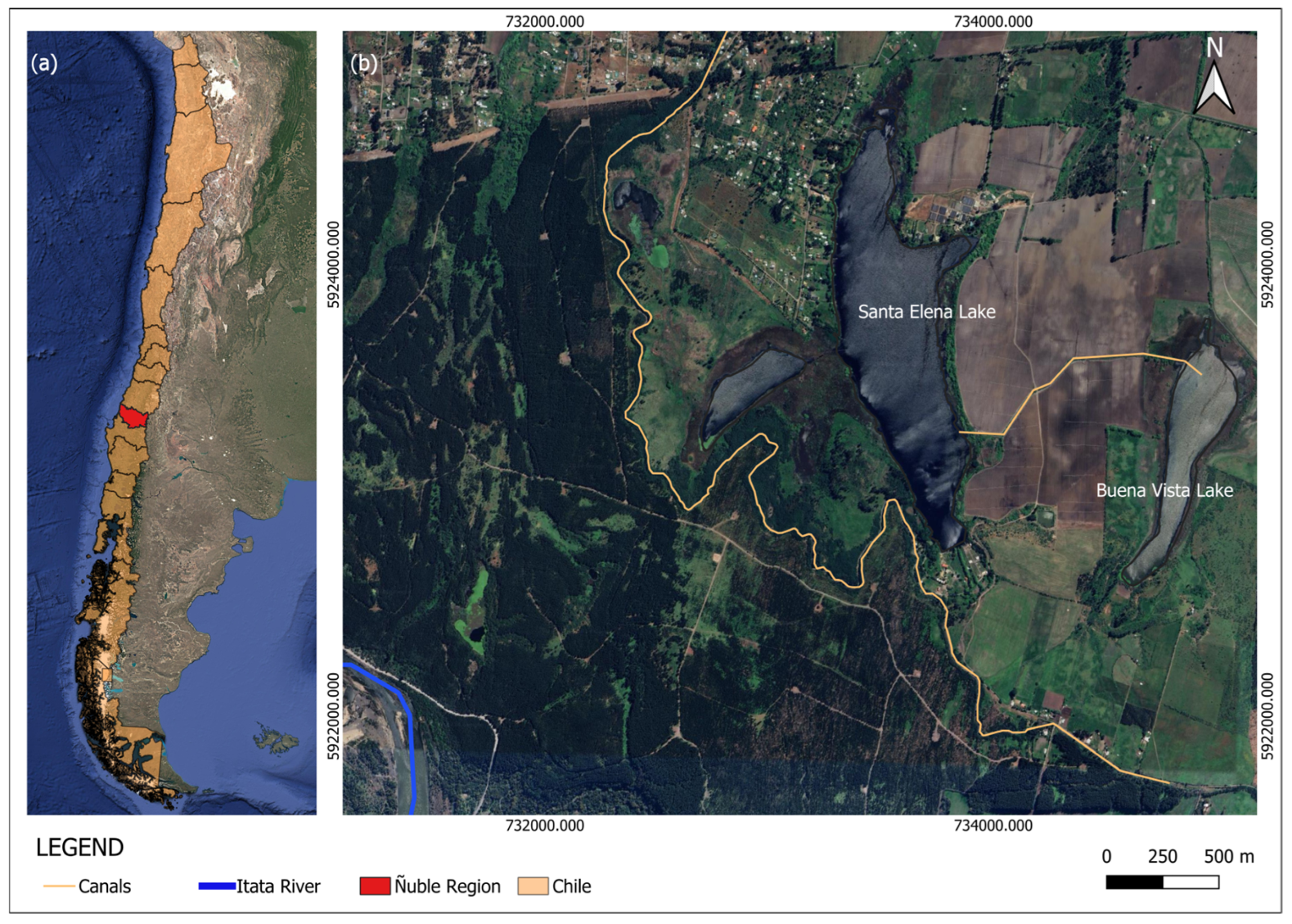
2.1. Study Area
2.2. Methods
2.2.1. Background Review
2.2.2. GIS Data Layers
2.2.3. Multicriteria Analysis

| Parameter | Potential Scale | Class | Range | References |
|---|---|---|---|---|
| NDVI | Low | −0.09–0.28 | 1 | [35,36,40,41,42] |
| Medium | 0.285–0.345 | 2 | ||
| High | 0.345–0.55 | 3 | ||
| TWI | Low | −0.51–4 | 1 | [30,43,44] |
| Medium | 4–5.5 | 2 | ||
| High | 5.5–7.2 | 3 | ||
| Land use/cover | Low | Lake, reservoirs, ponds | 1 | [45,46,47,48,49] |
| Plantations | ||||
| Freshwater bodies | ||||
| Medium | Mixed forest | 2 | ||
| Grasslands | ||||
| High | Native forest | 3 | ||
| Shrubland | ||||
| Arborescent shrubland | ||||
| Grassland-shrubland | ||||
| Meadows | ||||
| Depth range | Low | 25–50 m | 1 | [50,51,52] |
| Medium | 10–25 m | 2 | ||
| High | 5–10 m | 3 | ||
| 0–5 m | ||||
| Geology | Low | Undifferentiated tonalites and granodiorites | 1 | [19,53] |
| Medium | Valley sediment | 2 | ||
| High | Gravel and sand | 3 | ||
| Sandstone and siltstone |
2.2.4. Mapping of Zones with High Groundwater Influence and Vegetation
2.2.5. Validation
3. Results and Discussion
3.1. SIG Layers
3.1.1. Geomorphology
3.1.2. Geology
3.1.3. Land Use/Cover
3.1.4. Static Water Level Range
3.1.5. TWI
3.1.6. NDVI
3.2. Vegetation Mapping
3.3. Validation
4. Conclusions
Supplementary Materials
Author Contributions
Funding
Data Availability Statement
Acknowledgments
Conflicts of Interest
References
- Junk, W.J.; An, S.; Finlayson, C.M.; Gopal, B.; Květ, J.; Mitchell, S.A.; Mitsch, W.J.; Robarts, R.D. EFFECTS OF CLIMATE CHANGE ON WETLANDS Current state of knowledge regarding the world’s wetlands and their future under global climate change: A synthesis. Aquat. Sci. 2013, 75, 151–167. [Google Scholar] [CrossRef]
- Ramsar, S.D. Manual de la Convención de Ramsar: Guía a la Convención sobre los Humedales; Secretaría de la Convención de Ramsar: Gland, Switzerland, 2006; 96p. [Google Scholar]
- Ramsar. 12a Reunión de la Conferencia de las Partes. Available online: https://www.ramsar.org/es/evento/12a-reunion-de-la-conferencia-de-las-partes (accessed on 27 April 2024).
- De la Hera, À.; Gurrieri, J.; Puri, S.; Custodio, E.; Manzano, M. Ecohydrology and hydrogeological processes: Groundwater–ecosystem interactions with special emphasis on abiotic processes. Ecohydrol. Hydrobiol. 2016, 16, 99–105. [Google Scholar] [CrossRef]
- Naumburg, E.; Mata-Gonzalez, R.; Hunter, R.G.; Mclendon, T.; Martin, D.W. Phreatophytic Vegetation and Groundwater Fluctuations: A Review of Current Research and Application of Ecosystem Response Modeling with an Emphasis on Great Basin Vegetation. Environ. Manag. 2005, 35, 726–740. [Google Scholar] [CrossRef] [PubMed]
- Aslam, R.A.; Shrestha, S.; Pandey, V.P. Groundwater vulnerability to climate change: A review of the assessment methodology. Sci. Total Environ. 2018, 612, 853–875. [Google Scholar] [CrossRef]
- Howard, J.; Merrifield, M. Mapping Groundwater Dependent Ecosystems in California. PLoS ONE 2010, 5, e11249. [Google Scholar] [CrossRef]
- El-Hokayem, L.; De Vita, P.; Usman, M.; Link, A.; Conrad, C. Mapping potentially groundwater-dependent vegetation in the Mediterranean biome using global geodata targeting site conditions and vegetation characteristics. Sci. Total. Environ. 2023, 898, 166397. [Google Scholar] [CrossRef]
- Kløve, B.; Ala-Aho, P.; Bertrand, G.; Gurdak, J.J.; Kupfersberger, H.; Kværner, J.; Muotka, T.; Mykrä, H.; Preda, E.; Rossi, P.; et al. Climate change impacts on groundwater and dependent ecosystems. J. Hydrol. 2014, 518, 250–266. [Google Scholar] [CrossRef]
- Hoyos, C.P.; Krakauer, N.Y.; Khanbilvardi, R.; Armstrong, R.A. A review of advances in the identification and characterization of groundwater dependent ecosystems using geospatial technologies. Geosciences 2016, 6, 17. [Google Scholar] [CrossRef]
- Hernandez, J.O. Ecophysiological effects of groundwater drawdown on phreatophytes: Research trends during the last three decades. Land 2022, 11, 2061. [Google Scholar] [CrossRef]
- Ministry of the Environment of Chile, United Nations Development Program (PNUD) and Global Environment Facility (GEF). National Biodiversity Strategy (2017–2030). Available online: https://estrategia-aves.mma.gob.cl/wp-content/uploads/2023/03/MMA_2017_Estrategia_Nacional_Biodiversidad_2017-2030.pdf (accessed on 3 May 2024).
- Bergamini, K.; Martínez, C.; Mollenhauer, K.; Pérez, C.; Hernández, J.; Gutiérrez, P. Toolkit para la gestión y conservación de humedales. Una propuesta de fortalecimiento a su actual institucionalidad. In Propuestas para Chile; Concurso de Políticas Públicas UC: Santiago, Chile, 2019; pp. 255–288. [Google Scholar]
- Ministerio del Medio Ambiente. Ministerio del Medio Ambiente. Plan Nacional de Protección de Humedales 2018–2022. 2018. Available online: https://mma.gob.cl/wp-content/uploads/2018/11/Plan_humedales_Baja_confrase_VERSION-DEFINITIVA.pdf (accessed on 26 September 2024).
- Orellana, F.; Verma, P.; Loheide, S.P.; Daly, E. Monitoring and modeling water-vegetation interactions in groundwater-dependent ecosystems. Rev. Geophys. 2012, 50, 3003. [Google Scholar] [CrossRef]
- Coruhlu, Y.E.; Baser, V.; Yildiz, O. Object-based geographical data model for determination of the cemetery sites using SWOT and AHP integration. Surv. Rev. 2021, 53, 108–121. [Google Scholar] [CrossRef]
- Erostate, M.; Huneau, F.; Garel, E.; Ghiotti, S.; Vystavna, Y.; Garrido, M.; Pasqualini, V. Groundwater dependent ecosystems in coastal Mediterranean regions: Characterization, challenges and management for their protection. Water Res. 2020, 172, 115461. [Google Scholar] [CrossRef] [PubMed]
- Meinzer, E. Plants as Indicators of Ground Water; US Government Printing Office: Washington, DC, USA, 1927.
- Jones, C.; Stanton, D.; Hamer, N.; Denner, S.; Singh, K.; Flook, S.; Dyring, M. Field investigation of potential terrestrial groundwater-dependent ecosystems within Australia’s Great Artesian Basin. Hydrogeol. J. 2020, 28, 237–261. [Google Scholar] [CrossRef]
- Naghibi, S.A.; Dashtpagerdi, M.M. Evaluation of four supervised learning methods for groundwater spring potential mapping in Khalkhal region (Iran) using GIS-based features. Hydrogeol. J. 2017, 25, 169–189. [Google Scholar] [CrossRef]
- Ozdemir, A. GIS-based groundwater spring potential mapping in the Sultan Mountains (Konya, Turkey) using frequency ratio, weights of evidence and logistic regression methods and their comparison. J. Hydrol. 2011, 411, 290–308. [Google Scholar] [CrossRef]
- Sener, E.; Davraz, A. Assessment of groundwater vulnerability based on a modified DRASTIC model, GIS and an analytic hierarchy process (AHP) method: The case of Egirdir Lake basin (Isparta, Turkey). Hydrogeol. J. 2013, 21, 701–714. [Google Scholar] [CrossRef]
- Duran-Llacer, I.; Arumí, J.L.; Arriagada, L.; Aguayo, M.; Rojas, O.; González-Rodríguez, L.; Rodríguez-López, L.; Martínez-Retureta, R.; Oyarzún, R.; Singh, S.K. A new method to map groundwater-dependent ecosystem zones in semi-arid environments: A case study in Chile. Sci. Total Environ. 2022, 816, 151528. [Google Scholar] [CrossRef]
- Elgueta, S.; Rubio, X. Estratigrafia del Terciario del Sector Occidental de la Depression Central Entre los 37° y 38°S; Servicio Nacional Geol. Mineria: Santiago, Chile, 1991; pp. 723–727. [Google Scholar]
- Santibáñez, Q.; Fernando. Atlas Agroclimático de Chile. Estado Actual y Tendencias del Clima. Tomo VI: Regiones de Aysén y Magallanes, Santiago. 2017. Available online: http://www.agrimed.cl/atlas/tomo4.html (accessed on 17 June 2024).
- González-Acuña, D.; Benavente, C.; Figueroa, R. Avifauna de la Laguna Santa Elena, Región de Biobío. Boletín Chil. De Ornitol. 2004, 10, 13–18. [Google Scholar]
- Miraki, S.; Zanganeh, S.H.; Chapi, K.; Singh, V.P.; Shirzadi, A.; Shahabi, H.; Pham, B.T. Mapping Groundwater Potential Using a Novel Hybrid Intelligence Approach. Water Resour. Manag. 2019, 33, 281–302. [Google Scholar] [CrossRef]
- Pal, S.; Kundu, S.; Mahato, S. Groundwater potential zones for sustainable management plans in a river basin of India and Bangladesh. J. Clean. Prod. 2020, 257, 120311. [Google Scholar] [CrossRef]
- Mallick, J.; Khan, R.A.; Ahmed, M.; Alqadhi, S.D.; Alsubih, M.; Falqi, I.; Hasan, M.A. Modeling Groundwater Potential Zone in a Semi-Arid Region of Aseer Using Fuzzy-AHP and Geoinformation Techniques. Water 2019, 11, 2656. [Google Scholar] [CrossRef]
- Qadir, J.; Bhat, M.S.; Alam, A.; Rashid, I. Mapping groundwater potential zones using remote sensing and GIS approach in Jammu Himalaya, Jammu and Kashmir. GeoJournal 2020, 85, 487–504. [Google Scholar] [CrossRef]
- Beven, K.J.; Kirkby, M.J. A physically based, variable contributing area model of basin hydrology/Un modèle à base physique de zone d’appel variable de l’hydrologie du bassin versant. Hydrol. Sci. J. 1979, 24, 43–69. [Google Scholar] [CrossRef]
- O’Loughlin, E.M. Prediction of Surface Saturation Zones in Natural Catchments by Topographic Analysis. Water Resour. Res. 1986, 22, 794–804. [Google Scholar] [CrossRef]
- Rodríguez-López, L.; Duran-Llacer, I.; González-Rodríguez, L.; Abarca-Del-Rio, R.; Cárdenas, R.; Parra, O.; Martínez-Retureta, R.; Urrutia, R. Spectral analysis using LANDSAT images to monitor the chlorophyll-a concentration in Lake Laja in Chile. Ecol. Inform. 2020, 60, 101183. [Google Scholar] [CrossRef]
- Szabó, S.; Elemér, L.; Kovács, Z.; Püspöki, Z.; Kertész, A.; Singh, S.K.; Balázs, B. NDVI dynamics as reflected in climatic variables: Spatial and temporal trends–a case study of Hungary. GIsci. Remote Sens. 2019, 56, 624–644. [Google Scholar] [CrossRef]
- Huntington, J.; McGwire, K.; Morton, C.; Snyder, K.; Peterson, S.; Erickson, T.; Niswonger, R.; Carroll, R.; Smith, G.; Allen, R. Assessing the role of climate and resource management on groundwater dependent ecosystem changes in arid environments with the Landsat archive. Remote. Sens. Environ. 2016, 185, 186–197. [Google Scholar] [CrossRef]
- Barron, O.V.; Emelyanova, I.; Van Niel, T.G.; Pollock, D.; Hodgson, G. Mapping groundwater-dependent ecosystems using remote sensing measures of vegetation and moisture dynamics. Hydrol. Process. 2014, 28, 372–385. [Google Scholar] [CrossRef]
- Doody, T.M.; Barron, O.V.; Dowsley, K.; Emelyanova, I.; Fawcett, J.; Overton, I.C.; Pritchard, J.L.; Van Dijk, A.I.; Warren, G. Continental mapping of groundwater dependent ecosystems: A methodological framework to integrate diverse data and expert opinion. J. Hydrol. Reg. Stud. 2017, 10, 61–81. [Google Scholar] [CrossRef]
- Molero, E.; Grindla, A.L.; Asensio, J.J. Escenarios de aptitud y modelización cartográfica del crecimiento urbano mediante técnicas de evaluación multicriterio. GeoFocus Int. Rev. Geogr. Inf. Sci. Technol. 2007, 7, 120–147. [Google Scholar]
- de Cos Guerra, O.; Martín Latorre, E. Evaluación Multicriterio y Delimitación de Espacios Funcionales: Aplicación SIG para la Definición de Mapas Comarcales. 2007. Available online: https://repositorio.unican.es/xmlui/bitstream/handle/10902/4380/SIG%20y%20evaluaci%c3%b3n%20multicriterio%20propuesta%20metodol%c3%b3gica.pdf?sequence=6&isAllowed=y (accessed on 18 August 2024).
- Ortiz, M.; Morales, L.; Silva, P.; Acevedo, E. Estimación del nivel freático a partir del NDVI Landsat en la Pampa del Tamarugal (Chile). Rev. De Teledetección 2012, 37, 42–50. [Google Scholar]
- Eamus, D.; Fu, B.; Springer, A.E.; Stevens, L.E. Groundwater dependent ecosystems: Classification, identification techniques and threats. In Integrated Groundwater Management: Concepts, Approaches and Challenges; Springer: Berlin/Heidelberg, Germany, 2016; pp. 313–346. [Google Scholar]
- Gou, S.; Gonzales, S.; Miller, G.R. Mapping Potential Groundwater-Dependent Ecosystems for Sustainable Management. Groundwater 2014, 53, 99–110. [Google Scholar] [CrossRef] [PubMed]
- Muñoz, N.A.C. Método Para la Caracterización de las Formas del Terreno en Zonas de Montaña Utilizando Modelos Digitales de Elevación. Caso: Departamento del Cauca. Universidad Nacional de Colombia. [Online]. 2013. Available online: https://repositorio.unal.edu.co/handle/unal/21209 (accessed on 18 August 2024).
- PArulbalaji; Padmalal, D.; Sreelash, K. GIS and AHP Techniques Based Delineation of Groundwater Potential Zones: A case study from Southern Western Ghats, India. Sci. Rep. 2019, 9, 2082. [Google Scholar] [CrossRef]
- Nosetto, M.D.; Jobbágy, E.G.; Paruelo, J.M. Land-use change and water losses: The case of grassland afforestation across a soil textural gradient in central Argentina. Glob. Change Biol. 2005, 11, 1101–1117. [Google Scholar] [CrossRef]
- Le Maitre, D.C.; Scott, D.F.; Colvin, C. Review of information on interactions between vegetation and groundwater. Water 1999, 25, 137–152. [Google Scholar]
- Jobbágy, E.G.; Jackson, R.B. Groundwater use and salinization with grassland afforestation. Glob. Change Biol. 2004, 10, 1299–1312. [Google Scholar] [CrossRef]
- Scanlon, B.R.; Jolly, I.; Sophocleous, M.; Zhang, L. Global impacts of conversions from natural to agricultural ecosystems on water resources: Quantity versus quality. Water Resour. Res. 2007, 43, 2–12. [Google Scholar] [CrossRef]
- Inzunza, E.H. Cambios en los Niveles de Aguas Subterráneas y su Efecto Sobre la Zona no Saturada y la Vegetación. Enfoque conceptual y numérico. 2014 Henseleit Inzunza, E. Cambios en los Niveles de Aguas Subterráneas y su Efecto Sobre la zona no Saturada y la Vegetación. Enfoque Conceptual y Numérico. 2014. Available online: https://repositorio.uchile.cl/handle/2250/115577 (accessed on 3 February 2025).
- Mould, D.J.; Frahm, E.; Salzmann, T.; Miegel, K.; Acreman, M.C. Acreman. Evaluating the use of diurnal groundwater fluctuations for estimating evapotranspiration in wetland environments: Case studies in southeast England and northeast Germany. Ecohydrology 2010, 3, 294–305. [Google Scholar] [CrossRef]
- Martinet, M.C.; Vivoni, E.R.; Cleverly, J.R.; Thibault, J.R.; Schuetz, J.F.; Dahm, C.N. On groundwater fluctuations, evapotranspiration, and understory removal in riparian corridors. Water Resour. Res. 2009, 45, 6–9. [Google Scholar] [CrossRef]
- Butler, J.J.; Kluitenberg, G.J.; Whittemore, D.O.; Loheide, S.P.; Jin, W.; Billinger, M.A.; Zhan, X. A field investigation of phreatophyte-induced fluctuations in the water table. Water Resour. Res. 2007, 43, 6–12. [Google Scholar] [CrossRef]
- Dresel, P.E.; White, M.; Zydor, H.; Griffioen, P.; Clark, R.; Reid, M. Development of a Method to Map Sensitivity of Groundwater Dependent Ecosystems in Victoria; Department of Primary Industries: Melbourne, Australia, 2010. [Google Scholar]
- Vera, P.G. Combinación lineal de capas ráster con QGIS. 2016. Available online: https://www.researchgate.net/profile/Pedro-Galindo-Vera/publication/301220759_Combinacion_lineal_de_capas_rater_con_QGIS/links/570d1f2d08ae3199889bb36d/Combinacion-lineal-de-capas-raster-con-QGIS.pdf (accessed on 30 August 2024).
- Sutherland, W.J. Ecological Census Techniques: A Handbook; Cambridge University Press: Cambridge, UK, 2006. [Google Scholar]
- Aquaterra. Estudio Hidrogeológico Cuencas Bío Bío e Itata. Cuenca Itata. Tomo 1: Informe Final. 1 December 2011. Available online: https://repositoriodirplan.mop.gob.cl/biblioteca/handle/20.500.12140/25823 (accessed on 28 September 2024).
- Anavalón Cabrera, A. Evolución tectonosedimentaria de los depósitos plio-pleistocenos del valle central de Chile, entre los 36° 50’ S y 38° 50’ S. 2018. Available online: https://repositorio.sernageomin.cl/handle/0104/25674 (accessed on 2 September 2024).
- Klausmeyer, K.; Howard, J.; Keeler-Wolf, T.; Davis-Fadtke, K.; Hull, R.; Lyons, A. Mapping Indicators of Groundwater Dependent Ecosystems in California: Methods Report; The Nature Conservancy: San Francisco, CA, USA, 2018. [Google Scholar]
- Ahumada, M.; Faúndez, L. Guía Descriptiva de los Sistemas Vegetacionales Azonales Hídricos Terrestres de la Ecorregión Altiplánica; Servicio Agrícola y Ganadero: Santiago, Chile, 2009. [Google Scholar]
- Martínez-Santos, P.; Díaz-Alcaide, S.; De la Hera-Portillo, A.; Gómez-Escalonilla, V. Mapping groundwater-dependent ecosystems by means of multi-layer supervised classification. J. Hydrol. 2021, 603, 126873. [Google Scholar] [CrossRef]
- El Concepto-Herramienta de la Seguridad Territorial y la Gestión de Humedales | Biodiversidad en la Práctica. Available online: https://revistas.humboldt.org.co/index.php/BEP/article/view/453 (accessed on 29 January 2025).
- Cámara Artigas, R.; Rodrigues de Viana, E.; Díaz del Olmo, F. Cartografía del Manglar de la Desembocadura del río Paraiba (Estado de Paraiba, Brasil) Como Instrumento Para la Gestión de Humedales Tropicales: Aplicación de Técnicas de Teledetección en Imágenes QuickBird y Landsat. In Biogeografía: Una Ciencia para la Conservación del Medio: (VI Congreso Español de Biogeografía, Alicante, 2010); Dialnet: La Rioja, Spain, 2010; pp. 425–433. ISBN 978-84-933457-1-6. Available online: https://dialnet.unirioja.es/servlet/articulo?codigo=3333673 (accessed on 29 January 2025).


| Name | Source | Information |
|---|---|---|
| Alaska Satellite Facility (ASF) | https://search.asf.alaska.edu/#/ | Digital elevation model (DEM) |
| National Geology and Mining Service (SERNAGEOMIN) | https://www.sernageomin.cl | Geology |
| National Forestry Corporation (CONAF) | https://www.conaf.cl/ | Land use/cover |
| General Water Directorate (DGA) | https://dga.mop.gob.cl/ | Static water level data |
| United States Geological Survey (USGS) | https://earthexplorer.usgs.gov/ | Satellite images for the calculation of spectral indices |
| Ministry of the Environment | www.mma.gob.cl | Environmental legislation and regulations for wetland protection |
| The Convention on Wetlands | www.ramsar.org | Information on wetlands in Chile |
| Scopus | https://www.scopus.com | Review of scientific articles on mapping of potential groundwater zones and conceptual aspects of vegetation in wetlands. Selection of geospatial parameters predictive of the presence of groundwater and vegetation |
| Web of Science | https://www.webofscience.com | |
| Google Scholar | https://scholar.google.com |
| Scientific Name | Common Name | Classification |
|---|---|---|
| Salix viminalis L. | Basket willow | Phreatophyte |
| Salix alba L. | White willow | |
| Salix babylonica L. | Weeping willow | |
| Populus nigra L. | Black poplar | |
| Peumus boldus Molina | Boldo | |
| Quillaja saponaria Molina | Soapbark | |
| Typha domingensis | Cattail | |
| Poaceae | Grasses | |
| Juncus articulatus | Rush | |
| Acacia dealbata | Silver wattle | Invasive |
| Rubus ulmifolius | Elmleaf blackberry | |
| Rosa eglanteria | Sweetbriar | |
| Acacia caven | Espino | |
| Pinus radiata | Pine | Forestry |
Disclaimer/Publisher’s Note: The statements, opinions and data contained in all publications are solely those of the individual author(s) and contributor(s) and not of MDPI and/or the editor(s). MDPI and/or the editor(s) disclaim responsibility for any injury to people or property resulting from any ideas, methods, instructions or products referred to in the content. |
© 2025 by the authors. Licensee MDPI, Basel, Switzerland. This article is an open access article distributed under the terms and conditions of the Creative Commons Attribution (CC BY) license (https://creativecommons.org/licenses/by/4.0/).
Share and Cite
Rodríguez, O.A.; Arumí, J.L.; Urrutia, R. Mapping Groundwater-Dependent Vegetation Zones: Application of GIS and Multicriteria Analysis with Field Validation. Water 2025, 17, 534. https://doi.org/10.3390/w17040534
Rodríguez OA, Arumí JL, Urrutia R. Mapping Groundwater-Dependent Vegetation Zones: Application of GIS and Multicriteria Analysis with Field Validation. Water. 2025; 17(4):534. https://doi.org/10.3390/w17040534
Chicago/Turabian StyleRodríguez, Osmel Abreu, José Luis Arumí, and Roberto Urrutia. 2025. "Mapping Groundwater-Dependent Vegetation Zones: Application of GIS and Multicriteria Analysis with Field Validation" Water 17, no. 4: 534. https://doi.org/10.3390/w17040534
APA StyleRodríguez, O. A., Arumí, J. L., & Urrutia, R. (2025). Mapping Groundwater-Dependent Vegetation Zones: Application of GIS and Multicriteria Analysis with Field Validation. Water, 17(4), 534. https://doi.org/10.3390/w17040534