Article

Effects of Climate Change on the Estimation of Extreme Sea Levels in the Ayeyarwady Sea of Myanmar by Monte Carlo

Department of Port, Waterway and Coastal Engineering, School of Transportation, Southeast University, Nanjing 211189, China
*
Author to whom correspondence should be addressed.
Water 2025, 17(3), 429; https://doi.org/10.3390/w17030429
Submission received: 25 December 2024 / Revised: 25 January 2025 / Accepted: 27 January 2025 / Published: 4 February 2025
(This article belongs to the Section Oceans and Coastal Zones)

Abstract

:
Comprehensive understanding and prediction of storm surge are vital for coastal hazard mitigation and prevention. To estimate extreme sea levels in the Ayeyarwady Sea of Myanmar, where long-term tidal data are unavailable, a hydrodynamic model capable of simulating storm surge, along with the Monte Carlo method for generating synthetic cyclones, was utilized. The effectiveness of this modeling approach in the Ayeyarwady seas was confirmed through validation against tidal levels and storm surges. After analyzing 17 selected historical cyclones, a synthetic cyclone history comprising 354 events was developed. Simulations driven by the generated cyclones were subsequently conducted. Based on the simulation results, the 50-year, 100-year, 200-year, and 1000-year sea levels at the research station were estimated to be 4.43 m, 4.83 m, 6.06 m, and 7.24 m, respectively. With a 10% intensification of cyclones and a sea level rise of 310 mm, these four vital parameters were predicted to be 5.03 m, 5.48 m, 6.95 m, and 8.43 m. The results of this study confirmed the significant effects of cyclone intensification and sea level rise. Moreover, the results provide valuable scientific insights for flood management and engineering design in the Ayeyarwady Sea of Myanmar.

1. Introduction

Storm surge caused by tropical cyclones is among the most destructive ocean disasters [1,2]. Several coastal countries, including Myanmar, India, Bangladesh, Pakistan, and Sri Lanka, experience storm surge disasters annually [3]. Over the past two centuries, an estimated 2.6 million individuals have lost their lives in extreme surge events [4]. A notable example is the Bhola cyclone in 1970, which generated a 9.1 m storm surge in Bangladesh and resulted in approximately 300,000 fatalities [5]. Similarly, in May 2008, Cyclone Nargis struck the Ayeyarwady Delta in Myanmar, causing the nation’s most devastating natural disaster. The cyclone not only claimed over 80,000 lives but also severely impacted the livelihoods of more than 7 million people [6]. Large-scale construction of coastal reclamation, road networks, and other infrastructure, along with rapid economic development, has increasingly concentrated populations in coastal regions. This trend reduces local resilience against storm surge events and heightens community vulnerability. In recent years, such disasters have consistently caused substantial harm to communities worldwide. As noted in the 2018 China Marine Disaster Bulletin, the storm surge triggered by Cyclone Mangkhut, which made landfall in China that year, caused direct economic losses of 24.57 billion yuan. Therefore, accurate and timely numerical forecasting of storm surges is critical for the construction and safety of coastal projects and is essential for disaster prevention and mitigation.
The growing impact of climate change has led to a marked change in the frequency of extremely high sea levels at ports, posing significant risks to the safety and functionality of existing coastal projects. In the context of global climate change, the risk of storm surges has notably increased. Feng Aiqing’s 2016 study [7] examined the increasing frequency of storm surge events in southeastern coastal regions of China and analyzed their hazards, vulnerabilities, and climate change impacts. In Europe, Bevacqua projected that compound flooding in European coastal regions is likely to worsen due to sea-level rise (SLR) and increased precipitation, particularly in the Mediterranean and northern Europe [8]. In Australia, Zheng Feifei identified a significant correlation between extreme rainfall and storm surges along the coastline, with regional and seasonal variations [9]. Wu Wenyan further demonstrated that the El Niño Southern Oscillation (ENSO) significantly influences this correlation, thereby increasing the risk of coastal flooding [10]. Additionally, Rehana reported a 46% rise in the risk of extremely low water quality in the Tunga–Bhadra River due to rising temperatures and reduced flow [11].
Concurrently, there is a pressing need to improve future coastal project design standards. Rising sea levels are expected to raise the engineering design baseline, while the increased frequency and intensity of extreme weather events, such as heavy rainfall, droughts, cyclones, and storm surges, will elevate design tide levels and increase wave heights for these designs. Given the high costs, substantial investments, and stringent safety requirements associated with coastal projects, it is crucial to incorporate climate change considerations into construction and safety standards. In the context of global warming, annual sea level rises are coupled with increasing intensity of storm surges making landfall in Southeast Asia. Consequently, direct economic losses caused by cyclones and storm surges are steadily increasing, highlighting the urgent need for innovative disaster prevention and mitigation strategies in coastal areas [12]. This escalating threat has driven researchers to develop accurate and timely prediction models, providing crucial insights to guide the design of coastal projects aimed at mitigating disasters in vulnerable regions.
Predicting extreme sea levels for various recurrence periods is crucial for effective port planning and design, necessitating extensive research in this area. Approaches to predicting these levels can be broadly classified into frequency analysis methods and numerical simulation methods. Frequency analysis methods are notable for their low computational requirements and ease of validation using long-term data. When such data are available, the Federal Emergency Management Agency (FEMA) endorses this method [13]. Common frequency analysis techniques include two-parameter models such as Gumbel, Weibull, and Lognormal, as well as the advanced three-parameter Generalized Extreme Value (GEV) method. For coastal waters in the Pacific, FEMA advocates the GEV model, which integrates Weibull, Gumbel, and Frechet distributions. Studies have shown that the GEV model has been successfully applied along the Pacific coast and in the northeastern United States [14]. Additionally, research conducted at Wusong Station in China has demonstrated the superior performance of the GEV model over other traditional approaches, including Gumbel, Weibull, and Lognormal models [15].
Frequency analysis methods based on well-known empirical distributions are relatively simple and indeed widely applied when long-period datasets of annual maximum sea level are available. However, tide gage stations with enough measured records of annual sea levels are seriously inadequate, especially in several developing countries. Application of the frequency analysis methods is limited by insufficient measured datasets. Shorter-term datasets may result in prediction errors of the extreme sea levels following the frequency analysis method.
For situations that lack sufficient long-term observational datasets, numerical simulation methods can be employed. The method of numerical analysis has been effectively employed in previous research on predicting extreme sea levels in locations such as Bohai Bay [16] and Sri Lanka [17]. This study also addresses the challenge of predicting extreme sea levels in the absence of extensive historical sea level datasets by exploring numerical simulation methods. These methods employ meteorological and astronomical tide data, alongside other relevant driving factors with accurate historical records, as input parameters for hydrodynamic simulations. This approach enables hydrodynamic models to integrate meteorological statistical data with unknown sea levels, facilitating the prediction of extreme sea levels based on meteorological factors. For statistical analysis of meteorological factors, such as wind, pressure, and cyclone path data, the Empirical Simulation Technique (EST) [18], the Joint Probability Method (JPM) [19], and Monte Carlo [20] are commonly utilized. These methods are endorsed by FEMA for scenarios where long-term tidal data are unavailable. The EST method, which relies entirely on historical cyclone data from the study area, shares similar sampling error limitations with frequency analysis methods. The JPM [21] considers all possible combinations of cyclone parameters for the study area and assigns occurrence probabilities as weights to each combination. The occurrence rate of each simulated storm, generated in this manner, reflects the overall storm occurrence frequency within the study region.
Conversely, the Monte Carlo method stochastically assigns cyclone parameters using cumulative probability distribution functions and is particularly effective in addressing astronomical tide-related challenges. Compared to alternative approaches, the Monte Carlo method offers a distinct advantage as it does not necessitate the discretization of probability distributions, thereby enhancing its accuracy when addressing continuous distributions [22]. Contrary to alternative approaches, the Monte Carlo method does not necessitate the discretization of probability distributions, thereby enhancing its accuracy when handling continuous distributions. Furthermore, the Monte Carlo method proves particularly beneficial in scenarios characterized by limited data availability. Wang et al. [20] utilized this technique in Florida to forecast extremely high sea levels during storm surges for specific recurrence intervals. In Colombo, Sri Lanka, the historical hydrological data were insufficient for traditional frequency analysis to accurately predict extreme sea levels. To address this, an integrated ADIRC and SWAN hydrodynamic model was combined with a Monte Carlo model to forecast these extreme sea levels. This study’s estimates for the 50-, 100-, and 200-year return periods of extremely high sea levels are recommended for engineering design and planning purposes [17]. This methodology remains relevant today, especially when addressing astronomical tides.
Existing research has recognized the critical role played by climate change and the effectiveness of the Monte Carlo method. However, the effects of climate change on the extreme sea level estimation by Monte Carlo have not been fully examined. Meanwhile, the application of the Monte Carlo method in estimating extreme sea levels is still insufficient in Myanmar. This study focuses on the engineering and coastal waters of the LNG gas-fired power station project in Ayeyarwady Province, Myanmar. Due to the absence of long-term observed sea level data in the study area, it may be unreliable to predict extreme sea levels using frequency analysis methods. To address this, a numerical simulation study of potential cyclone storm surges is conducted, utilizing a combination of a random statistical model and a hydrodynamic model. In this investigation, the difficulty of estimating extreme sea levels without measured long-period data is overcome in the Ayeyarwady Sea of Myanmar. Estimation results offer a quantitative perspective on the effects of climate change on the Monte Carlo results, confirm the significant effects of cyclone intensification and sea level rise, and provide key insights for flood management and engineering design in the Ayeyarwady Sea of Myanmar.

2. Study Area

The LNG gas-fired power station project located in the Ayeyarwady Region of Myanmar and its surrounding coastal waters are the focus of this study. The Ayeyarwady Region, located in southwestern Myanmar, is one of the nation’s most densely populated, agriculturally prosperous, and navigationally crucial regions. This region is characterized by its distinctive geographical position and abundant natural resources, notably including the Ayeyarwady Delta and the Rakhine Mountain range, which extends into the northwest. It borders the Magway Region to the north, the Bago Region to the east, and the Andaman Sea to the south and southeast, thus serving as a crucial link between Myanmar’s interior and the ocean. Notably, parts of the Ayeyarwady Region directly overlook the Bay of Bengal, emphasizing its strategic importance. The region is renowned as a primary rice production hub and a key fishery zone in Myanmar, and it also contains valuable mineral resources, including oil and natural gas. The location of the study site is shown in Figure 1.
The Ayeyarwady Region, a critical economic zone in Myanmar, has been facing the impacts of monsoons and tropical cyclones in recent years. Initially, the heavy rainfall and strong winds associated with these weather phenomena can trigger flooding, severely disrupting local agriculture. For example, Cyclone Komen in the Bay of Bengal caused Myanmar to experience its most extensive flood in nearly four decades in 2015. The disaster affected over 530,000 hectares of farmland and aquaculture areas, resulting in widespread farmland destruction, crop failure, and significant disruptions to the lives and food security of residents [23]. Furthermore, storm surges induced by tropical cyclones can devastate coastal regions, including infrastructure and residential areas. Historical data show that the Ayeyarwady Delta was severely impacted by the Category 4 storm surge “Nargis” in 2008, leading to over 138,000 fatalities [24]. In addition, Cyclone Mocha, which made landfall in Myanmar in 2023, caused significant infrastructural damage and loss of life in Rakhine State and the Ayeyarwady Region.
These events highlight the vulnerability of the Ayeyarwady Region’s economic activities and ecosystems to extreme sea level fluctuations. Scientific forecasting and effective early warning systems can reduce disaster losses, protect residents’ lives and property, and provide strategic guidance for the region’s sustainable development. Therefore, it is essential to improve our understanding of extreme sea level fluctuations and conduct related predictive studies. The coastline of the Ayeyarwady Region is highly indented, with numerous offshore islands, and its complex hydrogeological conditions contribute to a highly intricate terrain and hydrodynamic processes in the region’s coastal waters [25].
In the study area, hydrometric observations show that a semidiurnal tide, with an average range of 1.52 m, predominates the engineering sea region. The interaction between spring tides and storm surges requires particular attention. The design and planning of the wharf for the LNG gas-fired power plant project in Myanmar’s Ayeyarwady Region must take extremely high sea levels at various recurrence intervals into account [26]. Given the limited historical sea level data, traditional frequency analysis is inadequate for predicting these extreme levels. In such cases, numerical simulation methods provide a viable alternative. Hydrodynamic models can link existing meteorological data with uncharted sea level data, enabling predictions of extreme sea levels based on meteorological parameters [27]. In this study, the Monte Carlo simulation method was adopted, and two typical cyclones that have had a significant impact on Myanmar and the areas near the project site in recent years, namely ‘the 1992 Sandoway Cyclone’ and’ the 1994 Sittwe Cyclone’, were selected as representative cyclones for research.

3. Numerical Methods

3.1. Description of Hydrodynamic Model

Currently, there is a wide range of numerical modeling software available for marine, coastal, and estuarine modeling. The performance of the commonly used hydrodynamic modeling packages of Delft3D (5.00.00) and MIKE 21 FM has been compared based on the results of hydrodynamic conditions predicted at Port Western Australia [28]. The results of the sea levels and tidal currents indicate that all of the models show comparable levels of calibration relative to the measured water level data, with a generally good agreement over the 29-day simulation. However, the Delft3D model exhibits superior prediction accuracy [29,30].
This study utilized the Delft3D model, a tool designed by the Dutch DELFT Hydraulics Research Institute. It is adept at executing two-dimensional hydrodynamic calculations in marine, coastal, and estuarine environments. Notably, the model exhibits robust performance when addressing the boundaries of intricate regions. Consequently, it has gained significant traction for examining tidal currents and storm surges in numerous nearshore marine locales. The Delft3D model is extensively applied internationally, such as in the Netherlands, Poland, Germany, Australia, and the United States, especially the latter, which has a long history of usage [14,17,28,31]. In the Hong Kong region of China, the Delft3D system has been used since the mid-1970s and has become a standard product of the Hong Kong Environmental Protection Department. Since the mid-1980s, Delft3D has also seen increasing applications in mainland China, such as at the mouth of the Yangtze River, Hangzhou Bay, Bohai Bay, Tai Lake, and Dian Lake [15,16].
As the core component of the Delft3D suite, the Delft3D-FLOW module adopts a coordinate as follows:
σ = z ζ d + ζ = z ζ H
where z is the vertical coordinate in physical space; z is 0 at the reference horizontal plane and at the riverbed. d is the water depth below the reference horizontal plane ( z = 0 ), ς   is the water depth above the reference horizontal plane, and H represents the total water depth.
The continuity equation relevant to two-dimensional water flow, along with the momentum equations in orthogonal curvilinear coordinates, are given below.
ς t + 1 G ξ ξ G η η d + ς U G η η ξ + 1 G ξ ξ G η η d + ς V G ξ ξ η = d + ς Q
u t + u G ξ ξ u ξ + v G η η u η + w d + ς u σ v 2 G ξ ξ G η η G η η ξ + u v G ξ ξ G η η G ξ ξ η f v = 1 ρ 0 G ξ ξ P ξ + F ξ + 1 ( d + ς ) 2 σ ( ν v v σ ) + M ξ
v t + u G ξ ξ v ξ + v G η η v η + w d + ς v σ + u v G ξ ξ G η η G η η ξ u 2 G ξ ξ G η η G ξ ξ η + f u = 1 ρ 0 G η η P η + F η + 1 ( d + ς ) 2 σ ( ν v v σ ) + M η
where t represents time; U and V denote the depth-averaged horizontal velocities in the ξ and η directions;   G ξ ξ and G η η   a r e the coordinate conversion factors in the ξ and η directions; ϕ is the Earth’s latitude; R   is the Earth’s radius; u ,   v ,   a n d w   denote the flow velocities in the ξ , η , and σ directions, respectively; f is the Coriolis parameter;   Ω is the Earth’s angular rotational velocity; ρ 0 is the reference water density; P ξ and P η represent the pressure gradients in the ξ and η directions; and v v is vertical eddy viscosity.
The hydrodynamic module of the Delft3D model is based on the Navier–Stokes equations. These equations are solved using shallow water assumptions and the Boussinesq approximation, resolving the Navier–Stokes equations for incompressible fluids. In the absence of vertical acceleration, the vertical momentum equation simplifies to the hydrostatic pressure equation. The three-dimensional model’s vertical flow velocities are derived from the continuity equation.

3.2. Description of Cyclone Model

To generate the transition wind and pressure field for hydrodynamic simulations during cyclone scenarios, the empirical wind field described by Jelesnianski was utilized [32,33]. The simulation scheme, combining the atmospheric pressure distribution model with the wind speed model, is commonly known as the Jele model [34]. The specific formulas for both atmospheric pressure and wind fields are detailed below:
When 0 r < R :
P a = P 0 + 1 4 r R 3 P P 0
W x = V d x r r + R W R r R 3 2 x x 0 s i n θ + y y 0 c o s θ
W y = V d y r r + R + W R r R 3 2 x x 0 c o s θ y y 0 s i n θ
When R r < :
P a = P 0 + 1 3 R 4 r P P 0
W x = V d x R r + R W R R r β x x 0 s i n θ + y y 0 c o s θ
W y = V d y R r + R + W R R r β x x 0 c o s θ y y 0 s i n θ
where r is the distance from the station to the cyclone center; R is the radius of maximum winds; P a is the pressure at a radial distance r from cyclone center; P is the ambient or environmental pressure; P 0 is the cyclone central pressure; β is the attenuation coefficient; V d x   and V d y are the cyclone forward speeds in the x and y directions; W R is the wind speed at the radius of maximum winds; θ is the angle of incidence; and W x and W y are the composite wind speeds in the x and y directions. Within this study, the key parameters are assigned the following values: P is equated to 1026.0 hPa, β is given a value of 0.5, and θ is set at 20°. The radius of the Earth, which is assumed to be 6371 km, is also used in calculating the speed of movement of the cyclone center.

3.3. Hydrodynamic Model Configuration

The orthogonal grid system was adopted in the Delft3D model, and a fully implicit finite difference scheme in space was utilized. The water depth at each grid node is calculated as a weighted average of the depths from several surrounding scattered points. To accurately simulate the storm surge resulting from a cyclone, the offshore open boundary in the numerical simulation of the storm surge must be positioned sufficiently far from the study area. This boundary is defined using sea-level time series obtained from the harmonic analysis module of the ADCIRC model. The model’s bathymetric data are based on topographical data and CAD drawings from the project documentation. Generating model grid and bathymetry are illustrated in Figure 2.
The model’s northern and eastern boundaries follow the mainland coastline, with the southern boundary at 8.0° North latitude and the western boundary at 85° East longitude, forming the offshore boundary. Such an expansive computational grid is designed to simulate the cyclone’s impact, focusing on storm surge variations as the cyclone transitions from open sea to coast, makes landfall, and moves inland. To closely replicate the actual conditions of the engineering site, the model grid was refined locally, encompassing 362,320 grid points. The grid is relatively coarse offshore, with a resolution of approximately 3.6 km, but becomes denser near the engineering site, with a resolution of 1 km. Due to the broad computational range spanning multiple latitudes and longitudes, the numerical simulation domain exhibits pronounced spherical characteristics. As a result, the model accounts for Earth’s curvature and map projection, employing a spherical coordinate system.
For the established hydrodynamic model grid, time series of atmospheric pressure and wind speed at each computed grid point were calculated following the cyclone model. The obtained cyclone wind and pressure field was then utilized as meteorological forcing for hydrodynamic simulations. The above procedure offers a solution to simulate storm tide during a cyclone event.

3.4. Hydrodynamic Model Validation

3.4.1. Tidal Level Validation

The temporary tidal station T1 (Figure 1), situated in the engineering water area, has a discrimination value of 0.274, categorizing it as a regular semi-diurnal tide. The tidal regime in this area is relatively consistent, with two high tides and two low tides occurring daily. However, a significant disparity in the duration of day and night tides is observed. The highest and lowest tidal levels recorded at station T1 were −155 cm and −404 cm, respectively, with an average tidal level of −282 cm. During the tidal observation period, the maximum tidal range at station T1 was 250 cm, the minimum was 35 cm, and the average tidal range was 152 cm. The average duration of the flood tide was 6 h and 14 min, while the average duration of the ebb tide was 6 h and 12 min.
A one-month dataset from the temporary tidal station T1 was utilized to validate simulated tidal levels. Figure 3 presents the tidal validation chart for station T1, covering the period from 00:00 on 5 March 2017 to 23:00 on 3 April 2017. The figure indicates a maximum tidal level error of 0.05 m and a minimum error of 0.014 m, both of which fall within acceptable specification standards.
Currently, only one month of tide level observation data from the temporary tide gauge station T1 in the project area is available. Although comprehensive one-year or multi-year measured tide level data are required to determine the design high sea level and design low sea level, such long measurements are unavailable. Given the limited data, this study utilizes the well-validated Delft3D model to reconcile and estimate tidal sea levels, projecting them for the entire year in the project area. This projection is subsequently used to establish the design of sea level parameters for the project area. The calculated mean sea level in the study area is 1.50 m, with a design high sea level of 2.58 m and a design low sea level of 0.45 m, based on the local low water surface (LWS) of the high tide as the reference datum.

3.4.2. Storm Surge Validation

To validate the cyclonic wind field model, two cyclones associated with severe storm surges in 1992 and 1994 were chosen for validation. These are the 1992 Sandoway Cyclone and the 1994 Sittwe Cyclone. The tracks of these two cyclones were illustrated in Figure 4. The wind and pressure fields were calculated using the formulas outlined in the previous section, which have demonstrated effectiveness in simulating cyclones in Myanmar and the surrounding waters. The accuracy of the cyclone model can be directly examined by comparing the computed pressure and wind speed with available measurements. When the measured pressure and wind speed are unavailable, the model can be indirectly evaluated by validating the storm surge forced by the cyclone model. In terms of the present investigation, due to the absence of regional meteorological data, direct validation of the time series of wind and pressure fields for the cyclones has difficulties. Therefore, this study utilized observed storm surge data from measurement stations in Myanmar’s maritime regions to indirectly validate the cyclone model. These data were obtained from Unisys Weather Information Systems.
The observed data revealed that during the 1992 Sandoway Cyclone, the maximum storm surge at the Sandoway and Gwa stations reached 1.4 m and 0.7 m, respectively. Similarly, during the 1994 Sittwe Cyclone, the maximum storm surge at the Sittwe and Sandoway stations reached 3.7 m and 0.8 m, respectively. By applying the wind and pressure field from these cyclones to the Delft3D-FLOW numerical model, the resulting storm surges were computed, assuming an ocean open boundary at a sea level of 0. Table 1 provides a comparison between the simulated surge data from the cyclone field model and the observed surge data. The results demonstrate strong agreement between the simulated surge data and the observations from Unisys Weather Information Systems. The close alignment between the simulated results and the observed values validates the suitability of the storm surge model for simulating storm surges in this maritime region and highlights its potential for future cyclone-induced storm surge studies.

4. Implementation of the Monte Carlo Approach

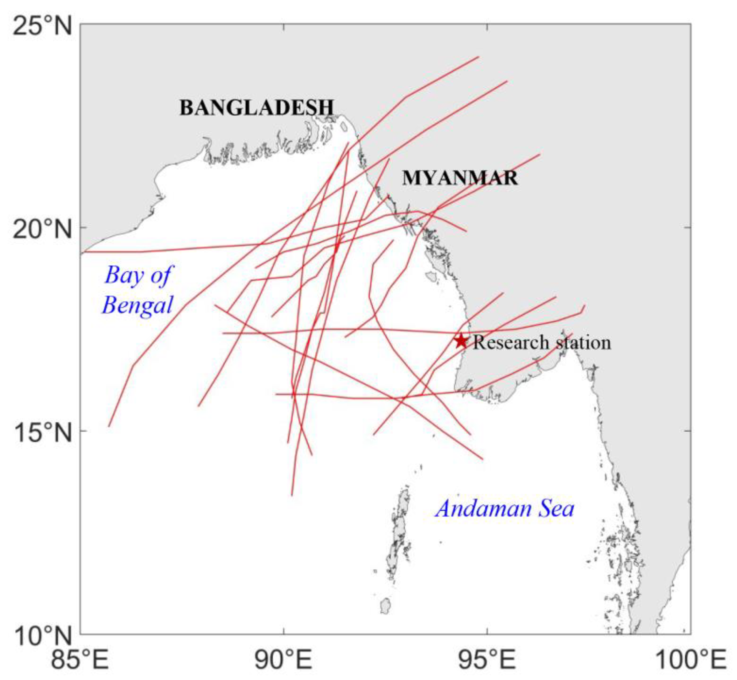
4.1. Selection of Historical Typical Cyclones

A historical cyclone data processing technique referred to as the “circular simulation method.” was adopted by FEMA. This method identifies all cyclones that have passed through a circular area centered on the simulation site, defined by a specific radius, within a specified timeframe. These identified cyclones serve as the foundation for this study.
The method focuses on cyclones within a 200 km radius of the engineering point, with central minimum pressure at the landfall point ranging from 0 to 980 hPa. An analysis of historical cyclone data revealed that 17 cyclones meeting these criteria were identified as typical for this study between 1963 and 2010. Each cyclone is referenced with its landfall point as point 6, with data from nine cyclone points, spaced six hours apart before and after landfall, analyzed. These tracks were presented in Figure 5, with the study area denoted by a pentagram.
Notably, Cyclone Nargis in 2008 was the most severe recent cyclone, devastating Myanmar with a peak wind speed of 59.2 m/s and a central pressure of 962 hPa. The most impactful cyclone in the study area occurred in 1982, with a maximum wind speed of 61.7 m/s and a storm surge of up to 4 m near GWA, less than 40 km from the LNG power plant study site. The selected typical cyclones can be characterized by the following parameters: Δ p   (central pressure),   R (radius of maximum wind), V F (forward speed),   θ (translation direction), and Y F (landfall or alongshore characteristics).

4.2. Generation of Synthetic Cyclone Tracks

Cyclone parameters, including Δ p (central pressure),   R (radius of maximum winds), V F (forward speed), θ   (translation direction), and Y F (landfall or alongshore characteristics), are mutually independent. The Monte Carlo random model is employed to generate these parameters, with the assumption that the cumulative probability distribution of each parameter follows a uniform distribution in the range [0,1]. By utilizing the random values generated by the model within the range [0,1] and the empirical cyclone data that defines the probability distribution of each parameter, the stochastic values of cyclone parameters can be derived. For instance, if the range of cyclone central pressure is [970 hPa, 996 hPa], following a normal distribution with a mean of 975 hPa and a standard deviation of 20 hPa, and the cumulative probability generated by the Monte Carlo simulation is 0.67, the corresponding cyclone central pressure is 983.8 hPa, as determined by the standard normal distribution. The random generation process for other parameters, such as R , V F , θ , and Y F , follows a similar approach. By integrating the Monte Carlo random model [35] with the probabilistic distribution functions of cyclone parameters, a series of simulated cyclone datasets can be generated for further research.
The Monte Carlo simulation technique is utilized to predict extreme sea levels influenced by storm surges, generating data for cyclones that may potentially occur over the course of a millennium. The simulation model is based on data from 17 representative cyclones that occurred between 1963 and 2010, with their tracks illustrated in Figure 5. As a result, the number of simulated cyclones over a span of 200 years can be calculated as n = 17⁄48 × 1000 ≈ 354. By simulating the parameters of these 354 potential cyclones, the required simulated cyclone data can be generated. The trajectories of these 354 simulated cyclones are shown in Figure 6.

5. Extreme Sea Levels in Myanmar’s Ayeyarwady Seas

5.1. Extreme Sea Level Estimation Under No Climate Change Influence

By analyzing cyclone statistical data, extremely high and low sea levels for a specified return period can be predicted by ranking the maximum and minimum values derived from the sea level time series. The 354 highest sea level values were ranked in descending order. Notably, the peak value in the sequence of maximum sea levels at the research site reached a height of 7.24 m relative to the Low Water Springs (LWS). The return period, denoted as TR, for the ranked tides can be estimated using the formula T R = 1000 M . Here, M represents the rank of the maximum storm tide, and TR denotes the return period.
For instance, this corresponds to the maximum value among the 354 extreme sea levels. The return period for this maximum sea level is subsequently calculated as TR1 = 1000/1 = 1000 years. Using this as a reference, the return periods corresponding to extremely high sea levels can be plotted, as shown in Figure 7, from which the extreme sea level values for any given return period can be determined. The highest sea levels ranked 1st, 5th, 10th, and 20th correspond to extremely high sea levels with return periods of 1000, 200, 100, and 50 years, respectively. Estimated these values are 7.24 m, 6.06 m, 4.83 m, and 4.43 m, respectively. The extremely low sea levels for different return periods are processed in the same manner, and their corresponding return periods are shown in Figure 7. The predicted extremely high and low sea levels for these return periods are provided in Table 2. Estimated 1000-year, 200-year, 100-year, and 50-year annual minimum sea levels are −2.19 m, −1.23 m, −0.52 m, and −0.24 m, respectively.

5.2. Extreme Sea Level Estimation Under Climate Change Influence

Based on predictions of extreme sea levels for different return periods, it is necessary to take the impact of climate change into consideration. The IPCC has provided a range of predictions for sea-level rise due to climate change, ranging from 90 mm to 700 mm over 75 years, with a median value of 380 mm over the same period. In this study, a 10% increase in cyclone intensity is considered as the influence of cyclone intensification on the study area, and a sea-level rise of 310 mm over 50 years is selected. For safety considerations, the predicted extremely high sea levels are adjusted to account for both cyclone intensification and sea-level rise over 50 years, while the predicted extremely low sea levels are adjusted only for the influence of cyclone intensification. The variation in storm surge for different return periods in the study area is presented in Table 3. Under the influence of cyclone intensification, an estimated 1000-year storm surge increases from 4.66 m to 5.54 m, while the 100-year storm surge increases from 2.25 m to 2.59 m.
The results of the extreme sea level calculations are presented in Table 4 and Table 5. Taking into account the impact of cyclone intensification and the predicted 50-year sea-level rise, the predicted extremely high sea levels at the research station for the 50-year, 100-year, 200-year, and 1000-year return periods are 5.03 m, 5.48 m, 6.95 m, and 8.43 m, respectively. Under the influence of cyclone intensification, the 1000-year, 200-year, 100-year, and 50-year annual maximum sea levels increase by 0.88 m, 0.58 m, 0.34 m, and 0.29 m, respectively. Under cyclone intensification and sea level rise scenarios, the increases of 1000-year, 200-year, 100-year, and 50-year annual maximum sea levels are 1.19 m, 0.89 m, 0.65 m, and 0.6 m, respectively. The predicted extremely low sea levels in the study area with only cyclone intensification for the 50-year, 100-year, 200-year, and 1000-year return periods are −0.49 m, −0.72 m, −1.59 m, and −2.73 m, respectively. The differences due to cyclone intensification are −0.25 m, −0.2 m, −0.36 m, and −0.54 m for the 50-year, 100-year, 200-year, and 1000-year return periods.

6. Conclusions

This study presents an approach for simulating and assessing the impacts of severe cyclonic storms and storm surges on critical engineering zones in Myanmar’s coastal regions, despite the lack of long-term tidal data. By integrating the Monte Carlo stochastic model with the Delft3D-FLOW hydrodynamic model, data limitations were overcome and essential hydrological parameters for engineering design in the study area were provided. The calculated average sea level is 1.50 m, the designed high sea level is 2.58 m, and the designed low sea level is 0.45 m. For return periods of 50, 100, 200, and 1000 years, the predicted extremely high sea levels are 4.43 m, 4.83 m, 6.06 m, and 7.24 m, respectively, while the extremely low sea levels are −0.24 m, −0.52 m, −1.23 m, and −2.19 m. Cyclone intensification and sea level rise have significant influences on the extreme sea levels. Under the cyclone intensification of 10% and sea level rise of 310 mm, the 1000-year, 200-year, 100-year, and 50-year annual maximum sea levels reach 8.43 m, 6.95 m, 5.48 m, and 5.03 m. As for the extremely low sea level, the differences due to cyclone intensification are −0.25 m, −0.2 m, −0.36 m, and −0.54 m for the 50-year, 100-year, 200-year, and 1000-year return periods.
Estimation results provide valuable hydrological parameters for engineering design in the Ayeyarwady Sea of Myanmar. These results provide essential basic data that drives safe and sustainable coastal infrastructure, such as the LNG gas-fired power station. By incorporating these estimates, engineers can design structures that not only meet current hydrological conditions but also anticipate future changes, particularly those driven by climate change.
Nevertheless, the present study was still subject to several limitations. The accuracy of the Delft3D model was examined by validating tidal levels from a temporary tide gauge station and storm surge data from measurement stations in Myanmar’s maritime regions. The reliability of hydrodynamic simulations performed with the Delft3D model is restricted by limited measurements. Sufficient validation based on longer measurements at more stations is bound to increase the reliability of the hydrodynamic model. Future studies should focus on expanding the collection of long-term tidal data, particularly in critical coastal areas, to improve model reliability. The lack of detailed wind speed and sea level observations during storm surges limits the validation and refinement of cyclone models, introducing uncertainty into surge predictions. Therefore, future research should concentrate on acquiring more real-time wind and sea level data to optimize cyclone models and reduce prediction uncertainties. In future planning, enhancing long-term observational networks in coastal areas should be prioritized to improve the accuracy of disaster mitigation and early warning systems. Additionally, further refinement of hydrological models, accounting for the effects of climate change and sea-level rise, along with the use of advanced numerical simulation techniques, will be crucial for enhancing predictive capabilities and better informing disaster management strategies.

Author Contributions

Conceptualization, K.Y. and S.X.; methodology, K.Y. and S.X.; software, S.L.; validation, S.L.; formal analysis, L.H. and S.L.; investigation, L.H. and S.L.; resources, S.X.; data curation, S.L.; writing—original draft preparation, L.H.; writing—review and editing, K.Y.; visualization, K.Y.; supervision, S.X.; project administration, S.X.; funding acquisition, S.X. and K.Y. All authors have read and agreed to the published version of the manuscript.

Funding

This research was funded by the National Natural Science Foundation of China, grant number 52271266, 52471274.

Data Availability Statement

The data presented in this study are available upon request from the corresponding author.

Conflicts of Interest

The authors declare no conflicts of interest.

References

  1. Smith, A.B.; Katz, R.W. US billion-dollar weather and climate disasters: Data sources, trends, accuracy and biases. Nat. Hazards 2013, 67, 387–410. [Google Scholar] [CrossRef]
  2. Dube, S.K.; Jain, I.; Rao, A.D.; Murty, T.S. Storm surge modelling for the Bay of Bengal and Arabian Sea. Nat. Hazards 2009, 51, 3–27. [Google Scholar] [CrossRef]
  3. Karim, M.F.; Mimura, N. Impacts of climate change and sea-level rise on cyclonic storm surge floods in Bangladesh. Glob. Environ. Change 2008, 18, 490–500. [Google Scholar] [CrossRef]
  4. Nicholls, R. Storm Surges in Coastal Areas; World Bank: Washington, DC, USA, 2006. [Google Scholar]
  5. Frank, N.L.; Husain, S.A. The deadliest tropical cyclone in history? Bull. Am. Meteorol. Soc. 1971, 52, 438–445. [Google Scholar] [CrossRef]
  6. Dasgupta, S.; Laplante, B.; Murray, S.; Wheeler, D. Climate Change and the Future Impacts of Storm-Surge Disasters in Developing Countries. SSRN Electron. J. 2009, 1–22. [Google Scholar] [CrossRef]
  7. Feng, A.Q.; Gao, J.B.; Wu, S.H.; Liu, Y.H.; He, X.J. A review of storm surge disaster risk research and adaptation in China under climate change. Prog. Geogr. 2016, 35, 1411–1419. [Google Scholar] [CrossRef]
  8. Bevacqua, E.; Maraun, D.; Vousdoukas, M.I.; Voukouvalas, E.; Vrac, M.; Mentaschi, L.; Widmann, M. Higher probability of compound flooding from precipitation and storm surge in Europe under anthropogenic climate change. Sci. Adv. 2019, 5, eaaw5531. [Google Scholar] [CrossRef]
  9. Zheng, F.; Westra, S.; Sisson, S.A. Quantifying the dependence between extreme rainfall and storm surge in the coastal zone. J. Hydrol. 2013, 505, 172–187. [Google Scholar] [CrossRef]
  10. Wu, W.; Leonard, M. Impact of ENSO on dependence between extreme rainfall and storm surge. Environ. Res. Lett. 2019, 14, 124043. [Google Scholar] [CrossRef]
  11. Rehana, S.; Dhanya, C.T. Modeling of extreme risk in river water quality under climate change. J. Water Clim. Change 2018, 9, jwc2018024. [Google Scholar] [CrossRef]
  12. Roy, K.; Gain, A.K.; Mallick, B.; Vogt, J. Social, hydro-ecological and climatic change in the southwest coastal region of Bangladesh. Reg. Environ. Change 2017, 17, 1895–1906. [Google Scholar] [CrossRef]
  13. Wallace, E.E.; MacArthur, R.C.; Chowdhury, S.; Sakumoto, L.K. FEMA Coastal Flood Hazard Analysis and Mapping Guidelines for the Pacific Coast; ASCE Library: Reston, VR, USA, 2012; pp. 247–256. [Google Scholar] [CrossRef]
  14. Xu, S.; Huang, W. Frequency analysis for predicting 1% annual maximum water levels along Florida coast, US. Hydrol. Process. 2008, 22, 4507–4518. [Google Scholar] [CrossRef]
  15. Xu, S.; Huang, W. Estimating extreme water levels with long-term data by GEV distribution at Wusong station near Shanghai city in Yangtze Estuary. Ocean Eng. 2011, 38, 468–478. [Google Scholar] [CrossRef]
  16. Wang, F.; Liu, X.; Li, Y.; Yu, H.; Wen, M.; Hu, Y. Risk assessment of coastal flooding disaster by storm surge based on Elevation-Area method and hydrodynamic models: Taking Bohai Bay as an example. China Geol. 2024, 7, 494–504. [Google Scholar] [CrossRef]
  17. Xu, S.; Huang, W.; Zhang, G.; Gao, F.; Li, X. Integrating Monte Carlo and hydrodynamic models for estimating extreme water levels by storm surge in Colombo, Sri Lanka. Nat. Hazards 2014, 71, 703–721. [Google Scholar] [CrossRef]
  18. Scheffner, N.W.; Borgman, L.E.; Mark, D.J. Empirical simulation technique based storm surge frequency analyses. J. Waterw. Port Coast. Ocean Eng. 1996, 122, 93–101. [Google Scholar] [CrossRef]
  19. Myers, V.A. Joint Probability Method of tide Frequency Analysis Applied to Atlantic City and Long Beach Island, N.J.; Rutgers University Libraries: New Brunswick, NJ, USA, 1970. [Google Scholar]
  20. Wang, S.; Manausa, M.E.; Dean, R.; Walton, T. Combined Total Storm Tide Frequency Restudy for Gulf County, Florida; Florida State University: Tallahassee, FL, USA, 2007. [Google Scholar]
  21. Toro, G.R.; Resio, D.T.; Divoky, D.; Niedoroda, A.W.; Reed, C. Efficient joint-probability methods for hurricane surge frequency analysis. Ocean Eng. 2010, 37, 125–134. [Google Scholar] [CrossRef]
  22. Yu, S.; Wu, W.; Naess, A. Extreme value prediction with modified Enhanced Monte Carlo method based on tail index correction. J. Sea Res. 2023, 192, 102354. [Google Scholar] [CrossRef]
  23. Hussain, M.; Tajima, Y. Numerical investigation of surge–tide interactions in the Bay of Bengal along the Bangladesh coast. Nat. Hazards 2017, 86, 669–694. [Google Scholar] [CrossRef]
  24. Seeger, K.; Peffeköver, A.; Minderhoud, P.S.J.; Vogel, A.; Brückner, H.; Kraas, F.; Oo, N.W.; Brill, D. Evaluating flood hazards in data-sparse coastal lowlands: Highlighting the Ayeyarwady Delta (Myanmar). Environ. Res. Lett. 2024, 19, 084007. [Google Scholar] [CrossRef]
  25. Gayathri, R.; Bhaskaran, P.K.; Sen, D. Numerical Study on Storm Surge and Associated Coastal Inundation for 2009 AILA Cyclone in the Head Bay of Bengal. Aquat. Procedia 2015, 4, 404–411. [Google Scholar] [CrossRef]
  26. Russell, L.R. Probability Distributions for Hurricane Effects. ASCE Waterw. 1971, 97, 139–154. [Google Scholar] [CrossRef]
  27. Sheppard, D.; Slinn, D.; Hagen, S. Design Hurricane Storm Surge Pilot Study; ACM: New York, NY, USA, 2006. [Google Scholar]
  28. Symonds, A.M.; Vijverberg, T.; Post, S.; Van Der Spek, B.-J.; Henrotte, J.; Sokolewicz, M. Comparison between mike 21 fm, delft3d and delft3d fm flow models of western port bay, australia. Coast. Eng. Proc. 2017, 11, 1–12. [Google Scholar] [CrossRef]
  29. Putzu, S.; Enrile, F.; Besio, G.; Cucco, A.; Cutroneo, L.; Capello, M.; Stocchino, A. A Reasoned Comparison between Two Hydrodynamic Models: Delft3D-Flow and ROMS (Regional Oceanic Modelling System). J. Mar. Sci. Eng. 2019, 7, 464. [Google Scholar] [CrossRef]
  30. Kulikov, M.E.; Arkhipkin, V.S.; Medvedev, I.P.; Kovachev, S.A.; Krylov, A.A. Numerical Modeling of Extreme Sea Levels on the Laptev Sea Coast. Geosciences 2024, 14, 245. [Google Scholar] [CrossRef]
  31. Narulita, N.A.; Wiyono, R.U.A.; Halik, G.; Pratama, M. Tsunami—Tides Interaction of the South Coast of Jember Using Delft3D-Flow. J. Tek. Pengair. 2023, 14, 143–152. [Google Scholar] [CrossRef]
  32. Panigrahi, J.K.; Umesh, P.A.; Padhy, C.P.; Swain, J. Nearshore propagation of cyclonic waves. Nat. Hazards 2012, 60, 605–622. [Google Scholar] [CrossRef]
  33. Panigrahi, J.K.; Tripathy, J.K.; Murty, A.S.N. Extremity analysis of storm surge for fixing safe design water level. Nat. Hazards 2011, 56, 347–358. [Google Scholar] [CrossRef]
  34. Jelesnianski, C.P. A numerical calculation of storm tides induced by a tropical storm impinging on a continental shelf. Mon. Weather Rev. 1965, 93, 343–358. [Google Scholar] [CrossRef]
  35. Yasui, H.; Ohkuma, T.; Marukawa, H.; Katagiri, J. Study on evaluation time in typhoon simulation based on Monte Carlo method. J. Wind Eng. Ind. Aerodyn. 2002, 90, 1529–1540. [Google Scholar] [CrossRef]
Figure 1. Map of the study area and its adjacent coastal regions.
Water 17 00429 g001
Figure 2. Illustration of the model grid (a) and bathymetr (b).
Water 17 00429 g002
Figure 3. Comparison between observed and simulated sea levels from 00:00 on 5 March 2017, to 23:00 on 3 April 2017, at the temporary tidal station T1.
Water 17 00429 g003
Figure 4. Tracks of the 1992 Sandoway Cyclone and the 1994 Sittwe Cyclone.
Water 17 00429 g004
Figure 5. Map of the historical cyclone tracks.
Water 17 00429 g005
Figure 6. Illustration of the Monte Carlo procedure (a) and generated synthetic cyclone tracks (b).
Water 17 00429 g006
Figure 7. Estimated annual maximum and minimum sea levels under different return periods (Datum: LWS).
Water 17 00429 g007
Table 1. Comparison of observed and simulated storm surges for two cyclones.
CycloneSpecific SiteMaximum SurgeValue
1992 Sandoway CycloneSandowayMeasured1.4 m
Simulated 1.48 m
GwaMeasured0.7 m
Simulated0.73 m
1994 Sittwe CycloneSittweMeasured 3.7 m
Simulated3.76 m
SandowayMeasured0.8 m
Simulated0.83 m
Table 2. Estimated extreme sea levels at the research station (Datum: LWS).
Return Period (Year)Extremely High Sea Level (m)Extremely Low Sea Level (m)
504.43−0.24
1004.83−0.52
2006.06−1.23
10007.24−2.19
Table 3. Calculated storm surge elevations and depressions under different return periods.
Return Period (Year)Storm Surge (m)Storm Surge with Cyclone Intensification (m)
501.852.14
1002.252.59
2003.484.06
10004.665.54
Table 4. Estimated extreme sea levels at the research station with climate change influence (Datum: LWS).
Return Period (Year)Extremely High Sea Level with Cyclone Intensification (m)Extremely High Sea Level with Cyclone Intensification and Sea Level Rise (m)
504.725.03
1005.175.48
2006.646.95
10008.128.43
Table 5. Predicted extremely low sea levels at the research station with climate change influence (Datum: LWS).
Return Period (Year)Extremely Low Sea Level with Cyclone Intensification (m)
50−0.49
100−0.72
200−1.59
1000−2.73
Disclaimer/Publisher’s Note: The statements, opinions and data contained in all publications are solely those of the individual author(s) and contributor(s) and not of MDPI and/or the editor(s). MDPI and/or the editor(s) disclaim responsibility for any injury to people or property resulting from any ideas, methods, instructions or products referred to in the content.

