Article

Impacts of Changing Temperatures on the Water Budget in the Great Salt Lake Basin

1
Department of Plants, Soils & Climate, Utah State University, Logan, UT 84322, USA
2
Utah Water Research Laboratory, Utah State University, Logan, UT 84321, USA
3
Department of Watershed Sciences, Utah State University, Logan, UT 84322, USA
4
Ecology Center, Utah State University, Logan, UT 84322, USA
*
Authors to whom correspondence should be addressed.
Water 2025, 17(3), 420; https://doi.org/10.3390/w17030420
Submission received: 18 December 2024 / Revised: 23 January 2025 / Accepted: 30 January 2025 / Published: 2 February 2025

Abstract

:
Quantifying the water budget in the Great Salt Lake (GSL) basin is a nontrivial task, especially under a changing climate that contributes to increasing temperatures and a shift towards more rainfall and less snowfall. This study examines the potential impacts of temperature thresholds on the water budget in the GSL, emphasizing the influence on snowmelt, evapotranspiration (ET), and runoff under varying climate warming scenarios. Current hydrological models such as the Variable Infiltration Capacity (VIC) model use a universal temperature threshold to partition snowfall and rainfall across different regions. Previous studies have argued that there is a wide range of thresholds for partitioning rainfall and snowfall across the globe. However, there is a clear knowledge gap in quantifying water budget components in the Great Salt Lake (GSL) basin corresponding to varying temperature thresholds for separating rainfall and snowfall under the present and future climates. To address this gap, the study applied temperature thresholds derived from observation-based data available from National Center for Environmental Prediction (NCEP) to the VIC model. We also performed a suite of hydrological experiments to quantify the water budget of the Great Salt Lake basin by perturbing temperature thresholds and climate forcing. The results indicate that higher temperature thresholds contribute to earlier snowmelt, reduced snowpack, and lower peak runoff values in the early spring that are likely due to increased ET before peak runoff periods. The results show that the GSL undergoes higher snow water equivalent (SWE) values during cold seasons due to snow accumulation and lower values during warm seasons as increased temperatures intensify ET. Projected climate warming may result in further reductions in SWE (~71%), increased atmospheric water demand, and significant impacts on water availability (i.e., runoff reduced by ~20%) in the GSL basin. These findings underscore the potential challenges that rising temperatures pose to regional water availability.

1. Introduction

Quantifying and understanding the water balance in the Great Salt Lake (GSL) basin is crucial for water management, especially under a changing climate, as snowmelt and temperature-driven processes play important roles in quantifying water availability. Temperature projections suggest that warming trends are likely to persist and potentially intensify [1]. Typically, Utah experiences an increasing temperature trend and this is mostly significant in the GSL [2,3]. The GSL is a large terminal lake located in northern Utah in the United States. It relies primarily on evaporation as its outflow, which contributes to its high salinity, and it receives inflows from snow-fed tributaries such as the Bear, Weber, and Jordan rivers. Most regional climate models have predicted that average temperatures in Utah could rise by 3–6 °C by the 2060s and by 4–10 °C at the end of this century [4]. The role of warming temperatures in influencing hydrological systems suggest that higher temperatures will exacerbate the effects of streamflow reduction in various regions [5]. Temperature significantly influences runoff and other hydrological factors linked to snow processes and thus the snow water equivalent (SWE), primarily due to a tendency towards the earlier initiation of both snowmelt and the peak of streamflow [6]. The GSL watershed is snowmelt-dominated, indicating that the volume of water that translates into streamflow depends on the amount of water stored in snowpacks, typically referred to as SWE [7], and the soil properties of the watershed such as infiltration capacity and saturation rate [8]. The amount of precipitation and the structure of the snowpack also control the melting rate of snowpacks; thus, how quickly water runs out of a snowpack, and this is an important factor when modeling snowmelt runoff [9]. Snowmelt is strongly driven by the relationships between temperature, precipitation, and soil moisture, which contribute to the complexity of modeling these hydrological factors [10,11]. In addition, energy fluxes such as electromagnetic radiation in the form of shortwave and longwave radiation, turbulent heat fluxes due to sensible temperature gradients between the air and/or soil and the snowpack, and latent heat fluxes within the snowpack and from state changes such as freezing or sublimation play important roles in the melting rate of snowpacks [12,13]. For instance, Beaton et al. (2024) discuss how these heat fluxes, associated with increasing temperatures, influence runoff processes in snow-dominated regions like the GSL basin [14].
In the context of climate change, rising air temperatures will affect the timing of snowmelt and therefore the quantity of runoff by altering the total amount of precipitation, heat fluxes into the snowpack, and the longwave radiative transfers of heat from the atmosphere [15]. Nevertheless, climate change contributes to increasing temperatures and a shift towards more rainfall and less snowfall in terms of precipitation phases [16,17]. This shift poses challenges to accurately predicting water availability in snow-dependent basins [18]. The western U.S. watershed is further complicated by complex topography, limited precipitation observations, and extensive water management. Thomas et al. (2024) emphasize the need for more region-specific models to better capture local variations in precipitation [19]. Current hydrological models like the Variable Infiltration Capacity (VIC) model use a constant temperature threshold of 0.5 °C across different regions to separate snowfall and rainfall when inferring the water balance [20]. This temperature threshold is defined as the critical temperature at which precipitation occurs as rainfall or snowfall [21]. Specifically, a threshold of 0.5 °C indicates that precipitation is considered as snowfall when temperatures fall below 0.5 °C and as rainfall when temperatures exceed this threshold. However, previous studies have argued that there is a wide range of temperature thresholds for separating rainfall and snowfall [21,22]. There is a clear knowledge gap in understanding whether, to what extent, and how a universal temperature threshold for separating rainfall and snowfall would affect the quantification of water budget and water quantity in the Great Salt Lake watershed.
Water elevation in the GSL is sensitive to increases in temperatures due to the changes in streamflow, precipitation, and evaporation. The average streamflow into the GSL has been reduced over the years. Thus, during 2005–2010, it was close to 25% less than the average during 1950–2010 [3]. Similarly, using a longer time period of analysis (1850–2013), this decline was 39% and this was due to agriculture and other human water uses, reducing the lake elevation by 3.6 m [3,23,24]. The declining water elevation of the GSL has serious monetary costs for mineral extraction and brine shrimp production, though it is not limited by the challenges of aggregated diversions and return flows [25].
It also has implications on the ecological communities the lake supports (i.e., its surrounding wetlands) and poses health hazards resulting from toxic dust storms originating from the exposed lakebed [26]. Due to the above reasons, this study will employ a hydrological model (refer to Methods) to examine the effects of different temperature thresholds on the water budget/balance (i.e., precipitation, runoff, evapotranspiration, and water storage) and to predict the future water budget response to changing temperatures within the Great Salt Lake basin (Figure 1). The remainder of the report is organized as follows. Section 2 describes in detail the data and methods used for this study while Section 3 represents the results and discussion. Lastly, Section 4 summarizes the conclusions of the study.

2. Study Area, Data and Methods
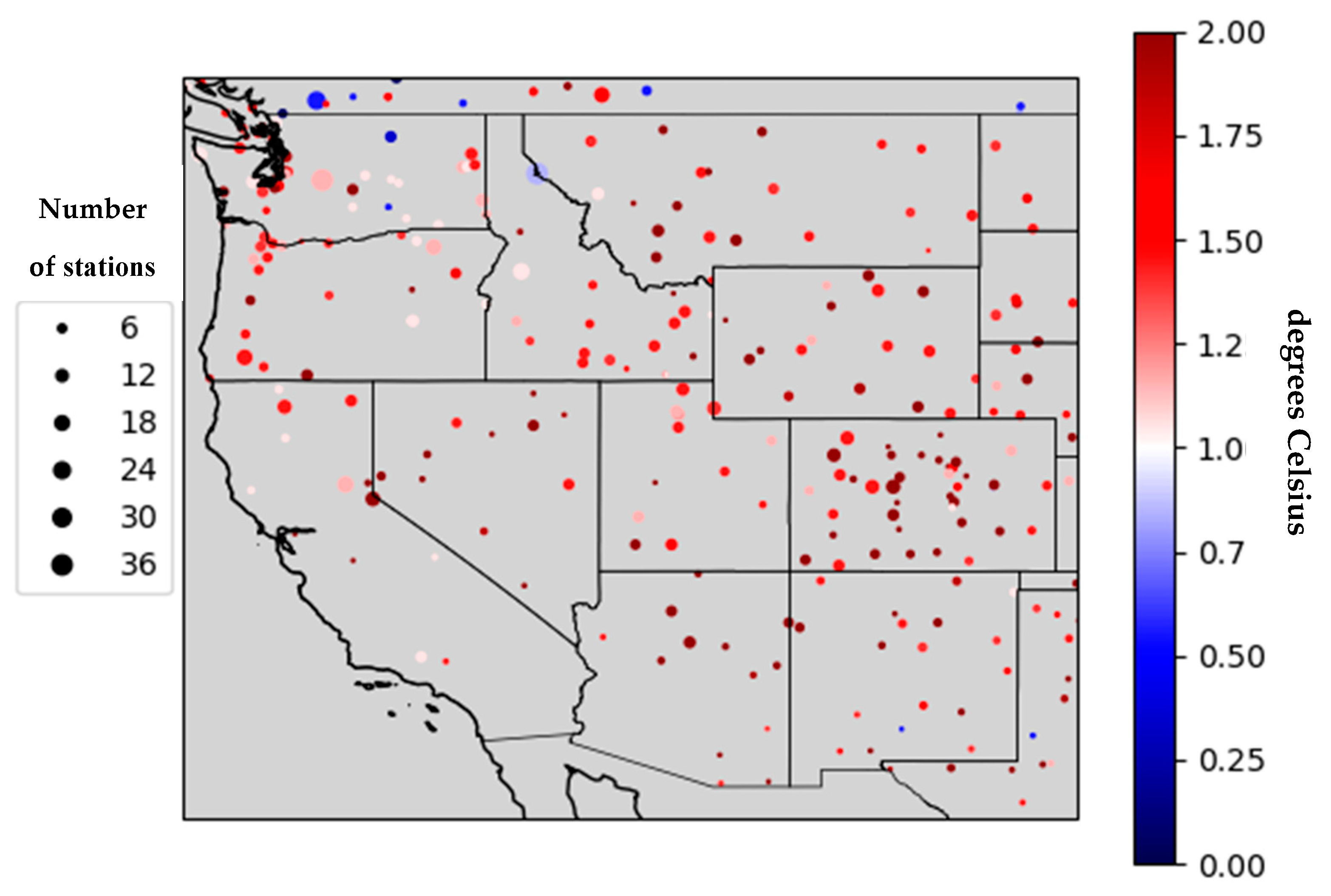
2.1. Study Area

The Great Salt Lake (GSL) is the fourth largest perennial and terminal lake in the world, located in northern Utah in the United States. It is a shallow (i.e., 4–6 m) and large (i.e., 3000–6000 km2) lake with a salinity in the range of 5–28% [27]. The GSL’s only outflow is evaporation, which changes with lake’s area, volume, and salinity, while its inflows are streamflow, precipitation (i.e., occurring mainly as snow in winter), and groundwater. The GSL watershed (i.e., 39.5° N to 43.5° N and −110.5° W to −113.5° W) merges parts of northern Utah, southern Idaho, and western Wyoming, resulting in an area of 53,264 km2, approximately with its basin’s topography ranging from 1224 m to 3865 m (Figure 1). A study conducted over the period 1847–2015 established that the main GSL snow-fed tributaries that emerge from mountains to the northeast, east, and southeast of the lake, are the Bear River (~58% of contribution), the Jordan River (~22%), the Weber River (~15%), and other small tributaries (~5%) [27]. However, it is important to note that these percentages may vary depending on the period of record and specific data sources. For instance, the surface water inflow for the GSL over the period 1987–1998 was distributed as follows: Bear River 55%, Jordan River 26%, Weber River 12%, and others 7% [28]. The GSL is divided into northern and southern arms because of the construction of the Union Pacific Railroad causeway [25]. The southern arm (i.e., Gilbert Bay) hosts brine shrimps, brine flies, and other hardy creatures, while the highly saline northern arm (i.e., Gunnison Bay) allows salt-tolerant populations of bacteria and a red-pigmented alga, resulting in a two-colored lake [28]. Daily discharge from the main tributaries of the Great Salt Lake (i.e., the Bear, Weber, and Jordon rivers) for the 2020 to 2023 water years is shown in Figure 1, highlighting the dominant contribution of the Bear River.

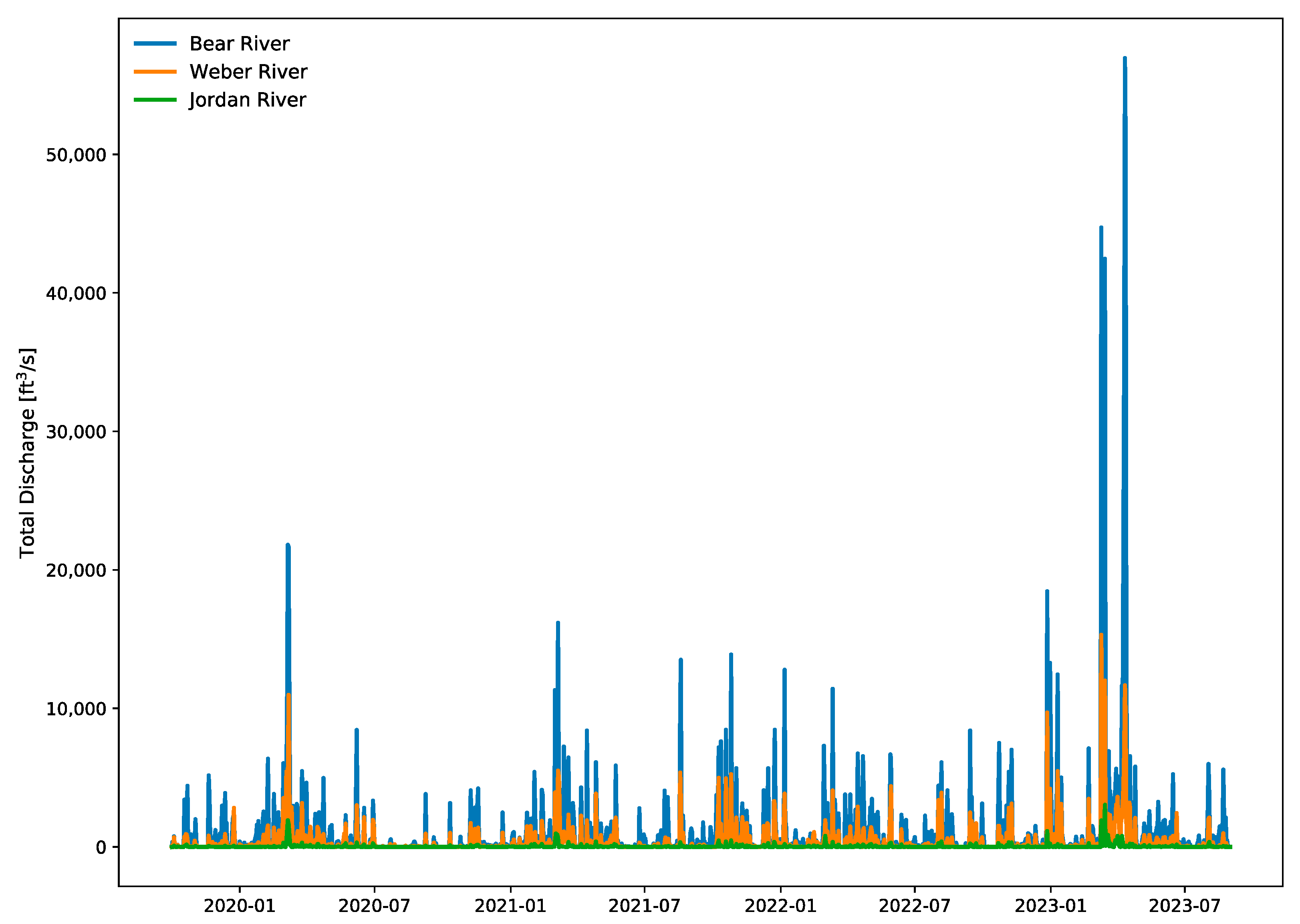
2.2. Data and Methods

The National Center for Environmental Prediction (NCEP) Automated Data Processing (ADP) Operational Global Surface Observational Weather dataset (DS464.0) hosted by NCEP (https://cmr.earthdata.nasa.gov/search/concepts/C1214053452-SCIOPS.html, accessed on 1 May 2024) provided 16,846,545 rainfall, snowfall, and surface air temperature observations from 1978 to 2007 [21,29]. Here, we use a machine learning-based decision tree method for deriving temperature thresholds that optimally separates rainfall and snowfall [30]. This allows us to unravel connections between variables in a different way from traditional statistical techniques. Unlike linear regression or other statistical models, decision trees handle non-linear relationships effectively, enabling more accurate predictions in complex datasets [31]. The method’s ability to handle both numerical and categorical data, as well as its robustness to outliers and missing values, allows for improved data utilization in decision-making processes [32]. This novelty in combining multiple trees into one robust model improves the stability and performance of predictions, providing superior insights compared to traditional methods [33,34].
Additionally, hydrology models can simulate water and energy balances across land surfaces over time. Specifically, the Variable Infiltration Capacity (VIC) hydrology model simulates various components of the water cycle, including evapotranspiration (ET), soil moisture, snow water equivalent (SWE), and runoff [35]. This model simulates complex land processes that occur in hydrological landscapes such as the Great Salt Lake (GSL). Meteorological variables, including precipitation, wind speed, vapor pressure, air temperature, surface pressure, incoming longwave, and shortwave radiation at the sub-daily timescale, are required to force the hydrology model. These variables were obtained from the European Centre for Medium-Range Weather Forecasts (ECMWF) Reanalysis Version 5 (ERA5; https://cds.climate.copernicus.eu/datasets, accessed on 1 May 2024) [36], spanning the water years from 2020 to 2023 (i.e., October–September), with a spatial resolution of 0.125° × 0.125° [37].
To test the effects temperature thresholds (i.e., the minimum temperature for rainfall and maximum temperature for snowfall) on the water budget (i.e., precipitation, runoff, evapotranspiration, snow water equivalent, and water storage), we enhanced the model’s functionality by adjusting its temperature thresholds by random increments of 2 °C, 3 °C, and 5 °C. Note that the default temperature threshold in the VIC model was 0.5 °C. The potential effects of climate warming on water budgeting in the GSL watershed were also examined by adding 2 °C, 3 °C, and 5 °C to the original temperature, forcing data derived from ERA5. Note that the water budget/balance framework [38] is described as:
P ET = d S d t + R + R 1
where P represents precipitation; ET is the evapotranspiration; d S d t represents the change in water storage; R is the runoff, and R1 represents the other residuals such as groundwater.

3. Results and Discussion

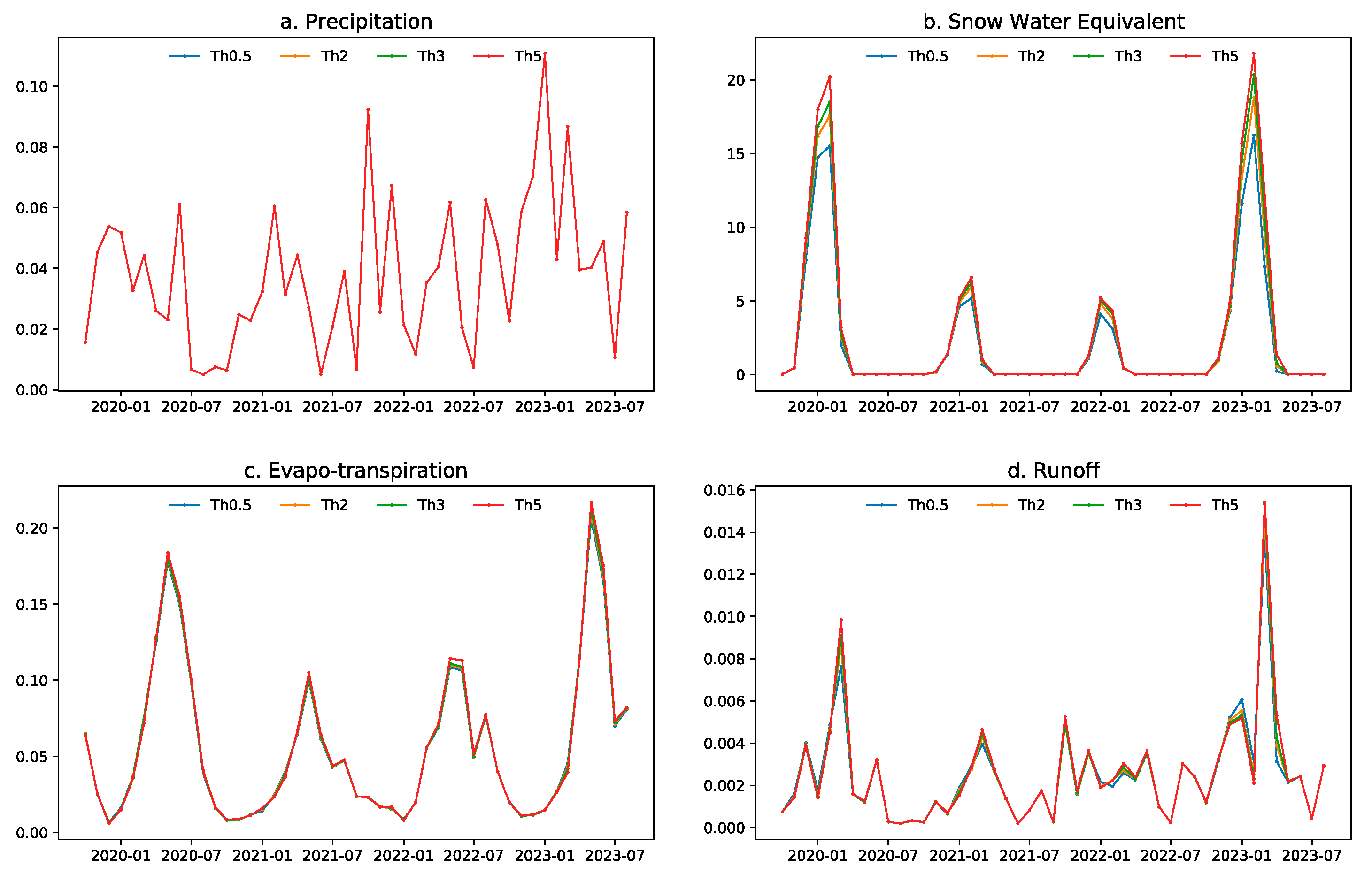
3.1. Various Temperature Thresholds

A key variable of the water balance is precipitation influenced by atmospheric variables such as relative humidity, pressure, and wind, all of which are linked to temperature [39]. As temperature increases, the water holding capacity of the air increases, mainly affecting extreme precipitation events as described by the Clausius–Clapeyron (CC) relationship [40]. This has been documented on a global scale with significant projected increases in yearly precipitation extremes; however, many studies have found that coherence with CC scaling differs across regions, time scales, and seasons [41]. While mean precipitation projections vary across regions, the temperature threshold for partitioning rainfall and snowfall remains unknown in the western U.S. Hydrology models such as the Variable Infiltration Capacity (VIC) model use 0.5 °C as a default and universal temperature threshold for separating rainfall and snowfall. However, by applying the decision tree method (refer to Methods), we found that there is a large spatial heterogeneity in the thresholds for rainfall–snowfall partitioning across the western U.S. (Figure 2). The lower temperature thresholds in the northwest suggest that colder conditions are required for the occurrence of snowfall and vice versa [21,42].
Specifically, we observe temperature thresholds close to 2 °C in the Great Salt Lake (GSL) basin (Figure 2), indicating that snowfall can occur when the temperature is below 2 °C in the region (see Figure 1). This suggests that traditional models such as VIC underestimate the complexity of water availability and climate variability in most regions [43]. We also tested the effects of various temperature thresholds (i.e., 0.5 °C, 2 °C, 3 °C, and 5 °C) on water budgeting (i.e., precipitation, runoff, evapotranspiration, and snow water equivalent) across the GSL basin. The results show that there are noticeable changes in runoff, which primarily contributes to the inflow of the GSL. For instance, a higher temperature threshold results in a higher peak runoff during the spring of 2020 and 2023 (Figure 3d) compared to 2021/2022 when there was a severe drought [20]. This is because in dry years runoff is low partly because much of the precipitation infiltrates or evaporates instead of running off a watershed as in wet years [44]. The increased runoff may be linked to a lower evapotranspiration prior to the peak runoff (Figure 3c). Additionally, snow water equivalent (SWE) exhibits a strong consistency with runoff (Figure 3b,d). Specifically, a higher temperature threshold for precipitation partitioning leads to a higher amount of snow water equivalent and runoff (Figure 3a).
Figure 4 describes the key components of the water budget equation (refer to Equation [1] in Methods): precipitation minus evapotranspiration (P-E), along with runoff plus the changes in soil water storage (R + dS/dt). The results indicate that P-E is consistent with the sum of runoff and water storage. There are remarkable seasonal changes in P-E, with positive values during cold seasons and negative values during warm seasons, due partly to the responses of evapotranspiration to temperatures (Figure 4a). Specifically, cold/warm temperatures drive less/more evapotranspiration. The above results suggest that changing temperature thresholds can affect the water budget in the GSL watershed, especially during the spring melt season. Note that the GSL’s water storage increases during winter and spring (i.e., November–June) and decreases during summer (i.e., July–October), as shown in Figure 4.

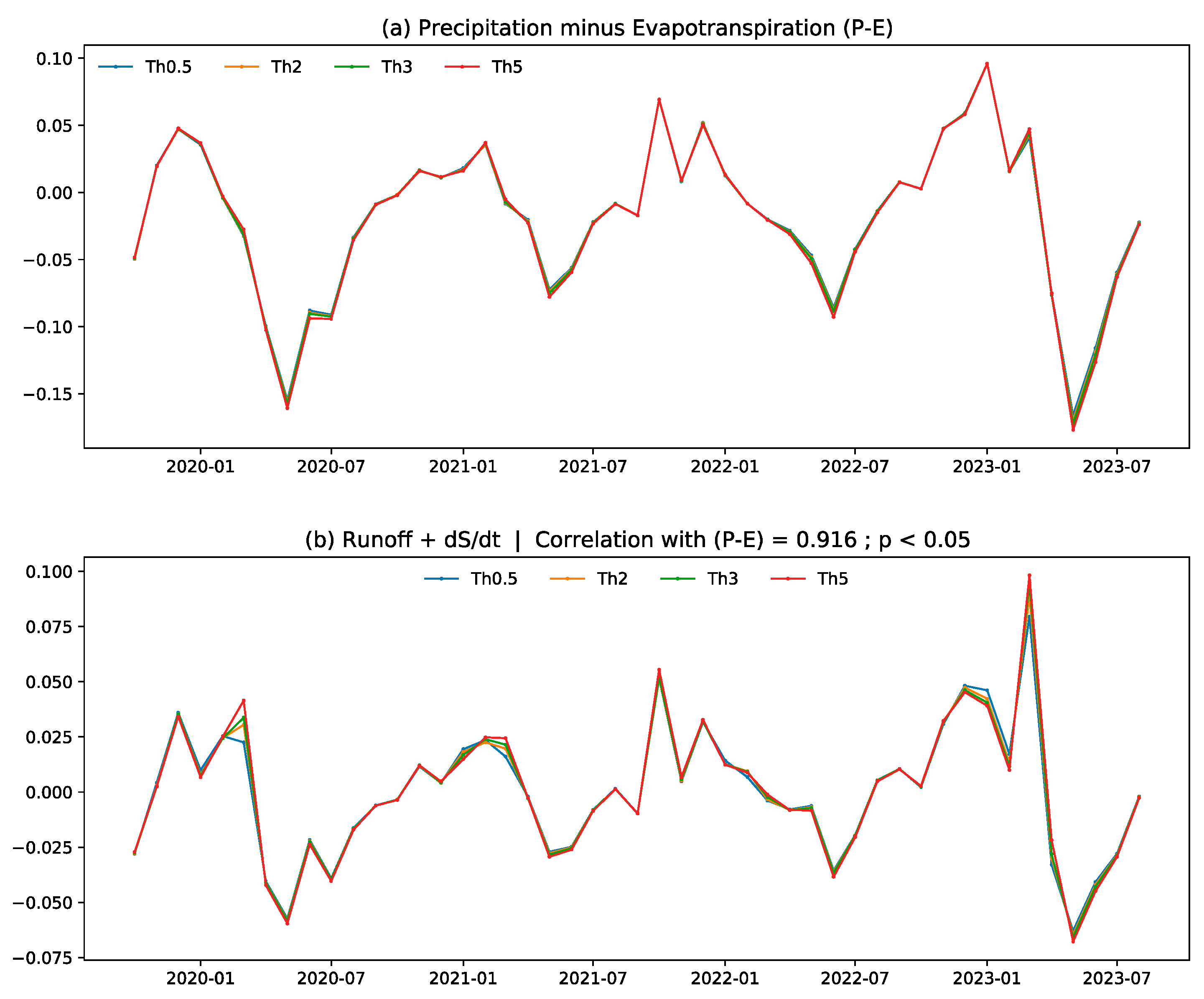
3.2. Effects of Temperature Warming

Temperature influences rain–snow partitioning and the evolution of the snowpack [22]. For instance, warmer temperatures tend to initiate earlier snowmelts and peak streamflow [6,7] and cause slower snowmelt rates due to the available energy during the melting season [45]. Projections indicate that the snowpack will decrease and evapotranspiration will increase due to earlier snowmelt by 2040 [3]. Furthermore, moderate and high emissions scenarios predict a slight reduction in the snowpack and an increase in drought frequency by 2100 [23,46]. Here, we evaluated the effects of future climate warming scenarios on the water budget in the GSL watershed using a hydrology model. Specifically, we modified the temperature forcing of the VIC model by adding 0 °C, 2 °C, 3 °C, and 5 °C to the original air temperature.
We observed that evapotranspiration (ET) increases with rising temperatures during the colder months (Figure 5a,c) when temperature-driven evaporation is limited by available moisture in snowpacks; thus, a low SWE (Figure 5b). As temperatures rise in spring and summer, ET rates generally continue to increase due to enhanced evaporation from both soil and plant surfaces. However, in late spring to early summer, ET decreases as the SWE diminishes (Figure 5b,c). Notably, runoff peaks in early spring, while ET reaches peaks later during late spring and early summer. As temperature increases, the peak runoff diminishes in early spring (Figure 5d), potentially due to excessive evapotranspiration prior to the peak runoff. The decreased runoff (~20%) is also reflected in a reduction in SWE (~71%) as temperature rises (Figure 5).
Overall, P-E is consistent with the sum of runoff and water storage with a significant correlation of 0.916 across all four VIC experiments. Temperature can enhance P-E during the cold season but reduces it during the warm season over the 2020–2023 water years (Figure 6a). During cold months, increased temperatures might reduce evapotranspiration due to frozen or snow-covered ground, leading to a higher P-E [47]. In contrast, during warm months, higher temperatures accelerate evapotranspiration and reduce snowpack, which depletes available water, thereby reducing P-E. Peak runoff and water storage peak in early spring, with low temperatures showing higher peaks (Figure 6b)—this may be tied to the shift towards an earlier snowmelt runoff due to increased temperatures [48]. Moreover, the projected climate based on LOCA2 by 2100 shows that surface air temperatures around the GSL basin could increase, resulting in a decline in the GSL water level due to reduced precipitation (Figure 7) and higher evaporation rates [3].

4. Conclusions

The responses of water availability to a warmer climate have strong implications for water resource management and planning because temperatures might modulate the water budget by affecting snowpack, evapotranspiration, precipitation amount, and rainfall–snowfall partitioning. Here, we have examined the potential impacts of temperature thresholds on the water budget in the GSL basin. This study has highlighted the significant influence of different temperature thresholds for partitioning rainfall and snowfall and warming on the water budget dynamics under different climate scenarios in the Great Salt Lake (GSL) basin by combining machine learning processes (i.e., decision tree methods), observations, and hydrology model simulations (i.e., VIC). In the Great Salt Lake (GSL) basin, the temperature threshold for rainfall–snowfall partitioning has been found to be close to 2 °C, which is higher than values in the Pacific Northwest. Our experiments have also demonstrated that higher temperature thresholds lead to a higher snow water equivalent (SWE) and peak spring runoff. This study further reveals that the temperature threshold for rain-to-snow separation varies significantly across different regions in the western U.S., ranging between 0 °C and 2 °C (refer to Figure 2). In contrast, hydrology models such as the Variable Infiltration Capacity (VIC) model assumed a fixed threshold of 0.5 °C, which may have overlooked this regional variability [21]. Recognizing this spatial heterogeneity is crucial for improving hydrological models and better predicting snowmelt-driven runoff under future climate warming [49]. Furthermore, warmer temperatures induce earlier snowmelt, leading to reduced SWE and a shift in runoff timing, especially in spring. Increased temperatures (e.g., 5 °C) enhance higher evapotranspiration (ET) during colder months, while high evaporation rates in warmer months deplete water storage.
Previous studies have also noted that snowpack dynamics in the GSL region are increasingly sensitive to warming [50] and could lead to substantial shifts in seasonal water availability, affecting both human and ecological water needs [51]. Meanwhile, precipitation minus evapotranspiration (P-E) rises in colder seasons due to increased snowfall but reduces in warmer seasons as warm temperatures enhance ET and diminish snowpacks. Note that this study adds temperature warming (e.g., 2–5 °C) to climate forcing without considering precipitation changes. This is because the future changes in precipitation corresponding to anthropogenic forcing are very uncertain [52]. Consistent with previous studies, anthropogenic forcing influences snowpack and streamflow patterns, highlighting the need for adaptive water management to mitigate future water shortages [53,54]. These results emphasize the importance of adaptive water management strategies to address temperature-driven changes in the water budget, ensuring the long-term resilience of the GSL and its surrounding ecosystems. This study also provides valuable insights for water managers to effectively allocate resources across sectors such as agriculture, drinking water, and industrial applications. Nevertheless, future work will focus on the impacts of projected precipitation changes to better understand the combined effects of warming and precipitation variability on water availability in the Great Salt Lake basin, with a particular emphasis on their implications for water resource management.

Author Contributions

Conceptualization, W.Z.; methodology and software, G.A., J.O., R.M., S.P.C., S.K., K.O.D., D.D., B.D., K.O.D., C.R. and W.Z.; validation, G.A. and W.Z.; formal analysis, G.A., J.O., R.M., S.P.C., S.K., K.O.D., K.O.D. and C.R.; investigation, G.A. and W.Z.; resources, W.Z.; writing—original draft preparation, G.A., J.O., R.M., S.P.C., S.K., K.O.D., D.D., B.D., K.O.D. and C.R.; writing—review and editing, G.A., J.O., R.M., S.P.C., S.K., K.O.D., D.D., B.D., K.O.D. and C.R.; visualization, G.A. and C.R.; supervision, W.Z.; project administration, W.Z.; funding acquisition, W.Z. All authors have read and agreed to the published version of the manuscript.

Funding

This research was partially supported by UAES Extension Water Initiative Grant, UAES hatch project, the U.S. Geological Survey under Grant No. G21AP10623 and Grant No. G24AP00051-00 through the Utah Center for Water Resources Research at the Utah Water Research Laboratory, and Bureau of Reclamation (R22AP00220 and R24AP00321). Funding for this project was partially provided by the National Oceanic and Atmospheric Administration (NOAA), awarded to the Cooperative Institute for Research on Hydrology (CIROH) through the NOAA Cooperative Agreement with The University of Alabama, NA22NWS4320003.

Data Availability Statement

Rainfall, snowfall, and surface air temperature datasets were obtained from the National Center for Environmental Prediction (NCEP) Automated Data Processing (ADP) Operational Global Surface Observational Weather dataset (DS464.0) hosted by NCEP (https://cmr.earthdata.nasa.gov/search/concepts/C1214053452-SCIOPS.html). Hourly meteorological variables such as precipitation, wind speed, vapor pressure, air temperature, surface pressure, incoming longwave, and shortwave radiation were also obtained from the European Centre for Medium-Range Weather Forecasts (ECMWF) Reanalysis Version 5 (ERA5; https://cds.climate.copernicus.eu/datasets).

Acknowledgments

We would like to thank the three reviewers for insightful comments.

Conflicts of Interest

The authors declare no conflicts of interest.

References

  1. Dettinger, M.; Udall, B.; Georgakakos, A. Western water and climate change. Ecol. Appl. 2015, 25, 2069–2093. [Google Scholar] [CrossRef] [PubMed]
  2. dos Santos, C.A.C.; Neale, C.M.U.; Rao, T.V.R.; da Silva, B.B. Trends in indices for extremes in daily temperature and precipitation over Utah, USA. Int. J. Climatol. 2011, 31, 1813–1822. [Google Scholar] [CrossRef]
  3. Mohammed, I.N.; Tarboton, D.G. An examination of the sensitivity of the Great Salt Lake to changes in inputs. Water Resour. Res. 2012, 48. [Google Scholar] [CrossRef]
  4. Khatri, K.; Strong, C. Climate Change, Water Resources, and Potential Adaptation Strategies in Utah; Division of Water Resources, Utah Department of Natural: Salt Lake City, UT, USA, 2020.
  5. Uwamahoro, S.; Liu, T.; Nzabarinda, V.; Li, Z.Y.; Umugwaneza, A.; Maniraho, A.P.; Kayumba, P.M.; Gulakhmadov, A.; Anming, B.; Abdullaev, F. Climatic and anthropogenic impacts on the water balance of Issyk-Kul Lake through its main catchments. Front. Water 2024, 6. [Google Scholar] [CrossRef]
  6. Adam, J.C.; Hamlet, A.F.; Lettenmaier, D.P. Implications of global climate change for snowmelt hydrology in the twenty-first century. Hydrol. Process. 2009, 23, 962–972. [Google Scholar] [CrossRef]
  7. Barnhart, T.B.; Molotch, N.P.; Livneh, B.; Harpold, A.A.; Knowles, J.F.; Schneider, D. Snowmelt rate dictates streamflow. Geophys. Res. Lett. 2016, 43, 8006–8016. [Google Scholar] [CrossRef]
  8. Dunne, T.; Black, R.D. Runoff Processes during Snowmelt. Water Resour. Res. 1971, 7, 1160–1172. [Google Scholar] [CrossRef]
  9. Tarboton, D.G.; Luce, C.H. Utah Energy Balance Snow Accumulation and Melt Model (UEB); Utah Water Research Laboratory: Logan, UT, USA, 1997. [Google Scholar]
  10. Aydin, M.C.; Gelberi, G.; Ulu, A.E. Investigation of recent level changes in Lake Van using water balance, LSTM and ANN approaches. Appl. Water Sci. 2024, 14, 41. [Google Scholar] [CrossRef]
  11. Zaerpour, M.; Hatami, S.; Ballarin, A.S.; Knoben, W.J.M.; Papalexiou, S.M.; Pietroniro, A.; Clark, M.P. Impacts of agriculture and snow dynamics on catchment water balance in the U.S. and Great Britain. Commun. Earth Environ. 2024, 5, 733. [Google Scholar] [CrossRef] [PubMed]
  12. DeWalle, D.R.; Rango, A. Principles of Snow Hydrology; Cambridge University Press: Cambridge, UK, 2008. [Google Scholar]
  13. Armstrong, R.L.; Brun, E. Snow and Climate: Physical Processes, Surface Energy Exchange and Modeling; Cambridge University Press: Cambridge, UK, 2008. [Google Scholar]
  14. Beaton, A.D.; Han, M.; Tolson, B.A.; Buttle, J.M.; Metcalfe, R.A. Assessing the impact of distributed snow water equivalent calibration and assimilation of Copernicus snow water equivalent on modelled snow and streamflow performance. Hydrol. Process. 2024, 38, e15075. [Google Scholar] [CrossRef]
  15. Javadinejad, S.; Dara, R.; Jafary, F. Climate Change Scenarios and Effects on Snow-Melt Runoff. Civ. Eng. J. 2020, 6, 1715–1725. [Google Scholar] [CrossRef]
  16. Wright, T.E.; Stuivenvolt-Allen, J.; Affram, G.; Hasan, N.A.; Ratterman, C.; Zhang, W. Responses of Extreme Discharge to Changes in Surface-Air and Dewpoint Temperatures in Utah: Seasonality and Mechanisms. Water 2023, 15, 688. [Google Scholar] [CrossRef]
  17. Zhang, W. The dry and hot American Southwest under the present and future climates. Atmos. Ocean. Sci. Lett. 2023, 16, 100340. [Google Scholar] [CrossRef]
  18. Sinyukovich, V.N.; Georgiadi, A.G.; Groisman, P.Y.; Borodin, O.O.; Aslamov, I.A. The Variation in the Water Level of Lake Baikal and Its Relationship with the Inflow and Outflow. Water 2024, 16, 560. [Google Scholar] [CrossRef]
  19. Thomas, S.; Lucius, M.A.; Kim, J.-Y.; Everham, E.M.; Dettmar, D.L.; Missimer, T.M. Water Budget for Lake Trafford, a Natural Subtropical Lake in South Florida: An Example of Enhanced Groundwater Influx in a Subtropical Lake Subsequent to Organic Sediment Dredging. Water 2024, 16, 1188. [Google Scholar] [CrossRef]
  20. Affram, G.; Zhang, W.; Hipps, L.; Ratterman, C. Characterizing the development and drivers of 2021 Western US drought. Environ. Res. Lett. 2023, 18, 044040. [Google Scholar] [CrossRef]
  21. Jennings, K.S.; Winchell, T.S.; Livneh, B.; Molotch, N.P. Spatial variation of the rain–snow temperature threshold across the Northern Hemisphere. Nat. Commun. 2018, 9, 1148. [Google Scholar] [CrossRef]
  22. Harpold, A.A.; Kaplan, M.L.; Klos, P.Z.; Link, T.; McNamara, J.P.; Rajagopal, S.; Schumer, R.; Steele, C.M. Rain or snow: Hydrologic processes, observations, prediction, and research needs. Hydrol. Earth Syst. Sci. 2017, 21, 1–22. [Google Scholar] [CrossRef]
  23. McDonald, G. Great Salt Lake Biology A Terminal Lake in a Time of Change. The Rozel Point Tar Seeps and Their Impact on the Local Biology at Great Salt Lake, Utah. 1 January 2020. Available online: https://www.academia.edu/43948143/Great_Salt_Lake_Biology_A_Terminal_Lake_in_a_Time_of_Change (accessed on 6 November 2024).
  24. Wine, M.L.; Null, S.E.; DeRose, R.J.; Wurtsbaugh, W.A. Climatization—Negligent Attribution of Great Salt Lake Desiccation: A Comment on Meng (2019). Climate 2019, 7, 67. [Google Scholar] [CrossRef]
  25. Merck, M.; Tarboton, D.G. Evaluating Variations in Great Salt Lake Inflow to Infer Human Consumptive Water Use, A Volume Reconstruction Approach. Available online: https://www.authorea.com/users/720996/articles/705972-evaluating-variations-in-great-salt-lake-inflow-to-infer-human-consumptive-water-use-a-volume-reconstruction-approach (accessed on 19 January 2025).
  26. Seltenrich, N. A Terminal Case? Shrinking Inland Seas Expose Salty Particulates and More. Environ. Health Perspect. 2023, 131, 062001. [Google Scholar] [CrossRef]
  27. Wurtsbaugh, W.; Miller, C.; Null, S.; Wilcock, P.; Hahnenberger, M.; Howe, F. Impacts of Water Development on Great Salt Lake and the Wasatch Front. Watershed Sciences Faculty Publications. 24 February 2016. Available online: https://digitalcommons.usu.edu/wats_facpub/875 (accessed on 6 November 2024). [CrossRef]
  28. Loving, B.L.; Waddell, K.M.; Miller, C.W. Water and Salt Balance of Great Salt Lake, Utah, and Simulation of Water and Salt Movement Through the Causeway, 1987–1998. U.S. Geological Survey; 2000. Report No.: 2000-4221. Available online: https://pubs.usgs.gov/publication/wri004221 (accessed on 6 November 2024). [CrossRef]
  29. Xu, H.; Duan, Y.; Li, Y.; Wang, H. Indirect Effects of Binary Typhoons on an Extreme Rainfall Event in Henan Province, China From 19 to 21 July 2021: 2. Numerical Study. J. Geophys. Res. Atmos. 2022, 127, e2021JD036083. [Google Scholar] [CrossRef]
  30. Friedl, M.A.; Brodley, C.E. Decision tree classification of land cover from remotely sensed data. Remote Sens. Environ. 1997, 61, 399–409. [Google Scholar] [CrossRef]
  31. Liaw, A.; Wiener, M. Classification and Regression by randomForest. R News 2002, 2, 18–22. [Google Scholar]
  32. Hastie, T.; Tibshirani, R.; Friedman, J. The Elements of Statistical Learning; Springer Series in Statistics; Springer: New York, NY, USA, 2009; Available online: http://link.springer.com/10.1007/978-0-387-84858-7 (accessed on 6 November 2024). [CrossRef]
  33. Breiman, L. Random Forests. Mach. Learn. 2001, 45, 5–32. [Google Scholar] [CrossRef]
  34. Chen, T.; Guestrin, C. XGBoost: A Scalable Tree Boosting System. In Proceedings of the 22nd ACM SIGKDD International Conference on Knowledge Discovery and Data Mining, KDD’16, San Francisco, CA, USA, 13–17 August 2016; Association for Computing Machinery: New York, NY, USA, 2016; pp. 785–794. Available online: https://dl.acm.org/doi/10.1145/2939672.2939785 (accessed on 6 November 2024). [CrossRef]
  35. Wi, S.; Ray, P.; Demaria, E.M.C.; Steinschneider, S.; Brown, C. A user-friendly software package for VIC hydrologic model development. Environ. Model. Softw. 2017, 98, 35–53. [Google Scholar] [CrossRef]
  36. Hersbach, H.; Bell, B.; Berrisford, P.; Hirahara, S.; Horányi, A.; Muñoz-Sabater, J.; Nicolas, J.; Peubey, C.; Radu, R.; Schepers, D.; et al. The ERA5 global reanalysis. Q. J. R. Meteorol. Soc. 2020, 146, 1999–2049. [Google Scholar] [CrossRef]
  37. Bell, B.; Hersbach, H.; Simmons, A.; Berrisford, P.; Dahlgren, P.; Horányi, A.; Muñoz-Sabater, J.; Nicolas, J.; Radu, R.; Schepers, D.; et al. The ERA5 global reanalysis: Preliminary extension to 1950. Q. J. R. Meteorol. Soc. 2021, 147, 4186–4227. [Google Scholar] [CrossRef]
  38. Ault, T.R. On the essentials of drought in a changing climate. Science 2020, 368, 256–260. [Google Scholar] [CrossRef]
  39. Gyasi-Agyei, Y. Evaluation of the effects of temperature changes on fine timescale rainfall. Water Resour. Res. 2013, 49, 4379–4398. [Google Scholar] [CrossRef]
  40. Trenberth, K.E. Conceptual Framework for Changes of Extremes of the Hydrological Cycle with Climate Change. Clim. Change 1999, 42, 327–339. [Google Scholar] [CrossRef]
  41. Berg, P.; Haerter, J.O.; Thejll, P.; Piani, C.; Hagemann, S.; Christensen, J.H. Seasonal characteristics of the relationship between daily precipitation intensity and surface temperature. J. Geophys. Res. Atmos. 2009, 114. [Google Scholar] [CrossRef]
  42. Nolin, A.W.; Daly, C. Mapping “At Risk” Snow in the Pacific Northwest. 1 October 2006. Available online: https://journals.ametsoc.org/view/journals/hydr/7/5/jhm543_1.xml (accessed on 2 December 2024). [CrossRef]
  43. Sowby, R.B. Utah Is Not the Second-Driest State: A Lesson in Questioning Persistent Assumptions about Hydrology. J. Hydrol. Eng. 2024, 29, 02523001. [Google Scholar] [CrossRef]
  44. Tian, W.; Liu, X.; Liu, C.; Bai, P. Investigation and simulations of changes in the relationship of precipitation-runoff in drought years. J. Hydrol. 2018, 565, 95–105. [Google Scholar] [CrossRef]
  45. Musselman, K.N.; Clark, M.P.; Liu, C.; Ikeda, K.; Rasmussen, R. Slower snowmelt in a warmer world. Nat. Clim. Change 2017, 7, 214–219. [Google Scholar] [CrossRef]
  46. Cook, B.I.; Mankin, J.S.; Anchukaitis, K.J. Climate Change and Drought: From Past to Future. Curr. Clim. Change Rep. 2018, 4, 164–179. [Google Scholar] [CrossRef]
  47. Rush, M.J.; Rajaram, H. Influence of Snowpack Cold Content on Seasonally Frozen Ground and Its Hydrologic Consequences: A Case Study From Niwot Ridge, CO. Water Resour. Res. 2022, 58, e2021WR031911. [Google Scholar] [CrossRef]
  48. McCabe, G.J.; Clark, M.P. Trends and Variability in Snowmelt Runoff in the Western United States. 1 August 2005. Available online: https://journals.ametsoc.org/view/journals/hydr/6/4/jhm428_1.xml (accessed on 12 November 2024). [CrossRef]
  49. Rhoades, A.M.; Jones, A.D.; Ullrich, P.A. The Changing Character of the California Sierra Nevada as a Natural Reservoir. Geophys. Res. Lett. 2018, 45, 13008–13019. [Google Scholar] [CrossRef]
  50. Khatri, K.B.; Strong, C.; Kochanski, A.K.; Burian, S.; Miller, C.; Hasenyager, C. Water Resources Criticality Due to Future Climate Change and Population Growth: Case of River Basins in Utah, USA. J. Water Resour. Plan. Manag. 2018, 144, 04018041. [Google Scholar] [CrossRef]
  51. EPA. Snowpack Change in the Western United States. ArcGIS StoryMaps. 17 January 2025. Available online: https://storymaps.arcgis.com/stories/65e98242e6a74c0db0932b1e2abe7051 (accessed on 20 January 2025).
  52. Pierce, D.W.; Cayan, D.R.; Feldman, D.R.; Risser, M.D. Future Increases in North American Extreme Precipitation in CMIP6 Downscaled with LOCA. 1 June 2023. Available online: https://journals.ametsoc.org/view/journals/hydr/24/5/JHM-D-22-0194.1.xml (accessed on 12 November 2024). [CrossRef]
  53. Barnett, T.P.; Adam, J.C.; Lettenmaier, D.P. Potential impacts of a warming climate on water availability in snow-dominated regions. Nature 2005, 438, 303–309. [Google Scholar] [CrossRef]
  54. Gillies, R.R.; Wang, S.-Y.; Booth, M.R. Observational and Synoptic Analyses of the Winter Precipitation Regime Change over Utah. 1 July 2012. Available online: https://journals.ametsoc.org/view/journals/clim/25/13/jcli-d-11-00084.1.xml (accessed on 20 January 2025). [CrossRef]
Figure 1. Daily total discharge from the main tributaries of the Great Salt Lake (i.e., the Bear, Weber, and Jordan rivers) for the 2020 to 2023 water years (see Methods in Section 2.2).
Water 17 00420 g001
Figure 2. The spatial distribution of temperature thresholds across the western U.S. for partitioning rainfall and snowfall derived by the decision tree method (refer to Methods). The size of the dots represents the number of observations/stations in thousands, while the color represents their various temperature thresholds.
Water 17 00420 g002
Figure 3. Monthly (a) precipitation, (b) snow water equivalent, (c) evapotranspiration, and (d) runoff across the Great Salt Lake basin simulated by VIC experiments in which four temperature thresholds (i.e., 0 °C, 2 °C, 3 °C, and 5 °C) were tested for the 2020 to 2023 water years (see Methods).
Water 17 00420 g003
Figure 4. Monthly (a) precipitation minus evapotranspiration (P − E) and (b) runoff + changes in water storage (dS/dt) simulated by VIC according to each temperature threshold during the water years from 2020 to 2023 across the Great Salt Lake basin. The top inscriptions represent the correlation between [P − E] and [Runoff + dS/dt] as well as its p-value.
Water 17 00420 g004
Figure 5. Monthly (a) air temperature, (b) snow water equivalent, (c) evapotranspiration, and (d) runoff across the Great Salt Lake basin simulated by the VIC model, where the original temperature forcing was increased by 0 °C, 2 °C, 3 °C, and 5 °C for the 2020 to 2023 water years (see Methods).
Water 17 00420 g005
Figure 6. Monthly (a) precipitation minus evapotranspiration (P − E) and (b) runoff + changes in water storage (dS/dt) simulated by the VIC model according to each temperature scenario during the water years from 2020 to 2023 across the Great Salt Lake watershed. The top inscriptions represent the correlation between [P − E] and [Runoff + dS/dt] as well as its p-value.
Water 17 00420 g006
Figure 7. Spatial map of historical (i.e., 1979–2020) and future (i.e., 2075–2100) (a) temperature and (b) precipitation composites across the Great Salt Lake watershed.
Water 17 00420 g007
Disclaimer/Publisher’s Note: The statements, opinions and data contained in all publications are solely those of the individual author(s) and contributor(s) and not of MDPI and/or the editor(s). MDPI and/or the editor(s) disclaim responsibility for any injury to people or property resulting from any ideas, methods, instructions or products referred to in the content.

