Article

Revitalization of Trakošćan Lake—Preliminary Analyses of the Sediment with the Possibility of Its Reuse in the Environment

Department of Water Management, Faculty of Geotechnical Engineering, University of Zagreb, Hallerova aleja 7, 42000 Varaždin, Croatia
*
Author to whom correspondence should be addressed.
Water 2025, 17(21), 3055; https://doi.org/10.3390/w17213055 (registering DOI)
Submission received: 12 September 2025 / Revised: 15 October 2025 / Accepted: 15 October 2025 / Published: 24 October 2025
(This article belongs to the Section Water Erosion and Sediment Transport)

Abstract

Trakošćan Lake is an artificial lake created in the mid-19th century for aesthetic and economic purposes. The area around the lake has been protected as park forest. Recently, the lake has become the most famous example of eutrophication in Croatia, as by 2022, a significant amount of sediment had accumulated in it. Therefore, the lake was drained that same year, followed by mechanical removal of the sediment. The total amount of sediment removed was 204,000 m3. After the removal work, a particularly important question arose of what to do with such a large amount of sediment. The objective of this research was to gain specific insight into the chemical composition of the sediment with the aim of its possible use in agricultural production for increasing the quality of arable land. A comprehensive qualitative geochemical and agrochemical analysis of the sediment composition was carried out for the first time, including indicators of the pH value, amount of organic matter and carbon, total nitrogen, available phosphorus and potassium, amount of carbonates, and the presence of metals, metalloids, and non-metals, of which As, Cd, Hg, and Pb are toxic. Electrochemical, spectrophotometric, and titration methods were used, along with three atomic absorption spectrometry techniques. The results of the analyses were interpreted in comparison with the natural substrate, as well as with the current regulations for agricultural land in the Republic of Croatia. According to this, sediment is not harmful for the environment.

1. Introduction

Aging, or eutrophication, is a natural process occurring in natural and artificial lakes. However, due to various environmental changes in ecosystems related to climate change and anthropogenic influences, the process of eutrophication of aquatic ecosystems can be significantly accelerated. In this process, algae and other aquatic plant species grow intensively, the amount of oxygen in water body decreases, animal species gradually become supplanted and extinct, and the aquatic lake ecosystems change colour to dark green and brown, gradually turning into swamps [1].
Dams represent significant human modifications to fluvial environments, intercepting an estimated 25–30% of the global riverine sediment load, worldwide [2]. In addition to the larger reservoirs, thousands of smaller reservoirs, flood control ponds, irrigation ponds, farm ponds, and other man-made water bodies exist throughout Europe. All these dams and ponds experience sediment deposition; however, the intensity of the sediment deposition process varies tremendously from one reservoir to the other. Sedimentation may be problematic but not important enough to measure it accurately. If it is measured, often only sediment volumes are reported, which is important for managing the reservoir, but this is not enough for calculating the sediment yield [3,4,5].
Over the years, large amounts of sediment are deposited in natural and artificial lakes created by damming river and stream beds, which are washed from the basin. The consequences of sedimentation include, among others, silting of the reservoir, more difficult passage of ice during the winter, and the accumulation of contaminants in the reservoir beds [6]. As a result of catchment erosion, all contamination generated in the corresponding basin areas accumulates in the sediment. There has been an increasing amount of research on these problems in past years, especially in the Netherlands and Italy [7,8,9,10]. The contaminants that dominate in sediment are phosphorus and heavy metals, and the largest causes of contamination are traffic and agriculture [11]. Concentrations vary depending on the hydrological and hydrographic characteristics of the basin (duration and intensity of precipitation, the occurrence of high waters and connection with the rest of the hydrographic network, as well as the contamination conditions in it), local geographical conditions, and others. Sediments in water bodies with an elevated content of heavy metals can have an adverse impact on the quality and usability of water in channels and reservoirs, as well as on the state of the environment, especially agricultural areas where it can be spread [12,13], and attention should be paid to it during sediment disposal [14].
Lake Trakošćan is located next to the famous Trakošćan Castle, in northern Croatia, right next to the border with the Republic of Slovenia. For more than 60 years, sediment has been accumulating in the lake, reducing the volume of the lake for receiving large amounts of water in the Bednja River basin, causing damage to flora and fauna, disrupting the quality and quantity of water in the lake, and creating challenges for tourism development projects.
When first formed, the lake had a functioning sediment removal system, where during fall, the lake was drained, and the winter period was used to clean the mud and sludge and refill the lake with water. The aim was to remove the deposited sediment from the lake and use low winter temperatures to freeze it for easier cleaning. At that time, the locals used the excavated sediment on their agricultural plots for improvement of the soil quality. However, the system was neglected over the years, and the lake filled with considerable amounts of sediment and debris [4]. Realising the importance of the preserving the Trakošćan lake, revitalisation works were recently carried out. Therefore, the lake was drained in November 2021 to clean the sediment from it. During the process, the fish were moved to other locations. In 2022, work on sediment excavation began to improve the lake’s ecological condition, and the projected depth of the lake was recovered.
In just over two years since the start of sediment extraction and lake restoration work, almost 204,656 m3 of sediment has been extracted from the area of Trakošćan lake. Geodetic measurements determined the volume of the loose state of the landfill to be around 238,000 m3, which is approximately the calculation of the volume of excavated sediment with a looseness coefficient of 1.2. The estimated total costs for the lake cleaning work amounted to EUR 4,869,131.07, with eligible costs of EUR 3,895,304.86 defined in the Grant Agreement [15]. Immediately before the start of the work and during the sediment extraction, the issue of its disposal arose, since river or lake sediment in the Republic of Croatia is treated as waste if it is moved from the place of its origin [16]. Its direct disposal into the environment, without prior treatment is prohibited, which increases the cost of the entire procedure.
Since the lake itself is located in a protected park forest, declared as such in 1955 [17], where there are no sources of contamination or any harmful effects on the lake basin itself, the assumption was that the sediment deposited at the bottom of the lake was actually harmless and even beneficial to the environment. Over the last few decades, there has been an increasing recognition that dredged sediment is a resource that should be used beneficially for human development activities and/or enhancement of ecological habitats [18]. Therefore, the objective of this research was to provide a detailed insight into the chemical composition of the lake sediment with the purpose of its possible use in agricultural production as a possible supplement to increase the quality of arable land, as it was the common practice decades ago. For this reason, an extensive qualitative geochemical and agrochemical analysis of the composition of the sediment deposited during the last sixty years was conducted for the first time. The obtained values were compared with the values of potentially toxic elements, i.e., MAC of metals and metalloids, regulated by the Ordinance on the Protection of Agricultural Land in the Republic of Croatia [19].

2. Study Area

Trakošćan Lake is located in the municipality of Bednja, Varaždin County, approximately 30 km west of the city of Varaždin and about 50 km north of the capital city Zagreb, near the Slovenian border (Figure 1). The lake was created between 1853 and 1862 through the construction of a dam on the Čemernica stream, as part of the park forest and the planned Trakošćan Nature Park, at the junction of the Macelj, Ravna Gora, and Strahinjčica mountains. It is a shallow artificial lake, covering an area of approximately 17 hectares, with a length of about 1.5 km [20]. Trakošćan Lake is recognised both as an important landscape feature complementing Trakošćan Castle and as a site historically used for fish farming.

2.1. Hydrology Characteristics

Trakošćan Lake was formed by the damming of the torrential stream Čemernica, while additional inflow is provided by several smaller non-perennial streams that typically dry up during the summer months. The topographic catchment area covers about 10.7 km2. The reservoir itself extends for approximately 1.5 km in length, with a surface area of 0.17 km2, an average depth of 2.5 m, and an estimated total volume of 392,000 m3, according to hydrotechnical surveys conducted in 1961 [21]. The lake drains towards the Bednja River and is situated at an elevation of around 240 m a.s.l. It is surrounded by relatively low hills, none exceeding an elevation of 400 m a.s.l., including Mali and Veliki Skrnik to the north (344 and 377 m a.s.l.) and Bukov Peak to the south (360 m a.s.l.). Despite the moderate elevation range, the landscape is characterised by steep ridges and ravines that support specific forest vegetation [5].
In 1981, a project was undertaken to regulate the southern torrents of the lake, addressing nine streams with a combined length of 3.25 km. Subsequent work between 1991 and 1994 included the reconstruction of the castle complex, accommodation, and catering facilities located beneath the castle, as well as the expansion and reopening of the Trakošćan hotel [4]. Nevertheless, the lake itself remained largely unmaintained. Of the northern inflows, only Jurin Creek was developed and leased for fish farming, though accessibility was limited due to an unpaved road prone to erosion by torrents on the steep slopes. Other northern tributaries were left entirely unmanaged and remained difficult to reach.
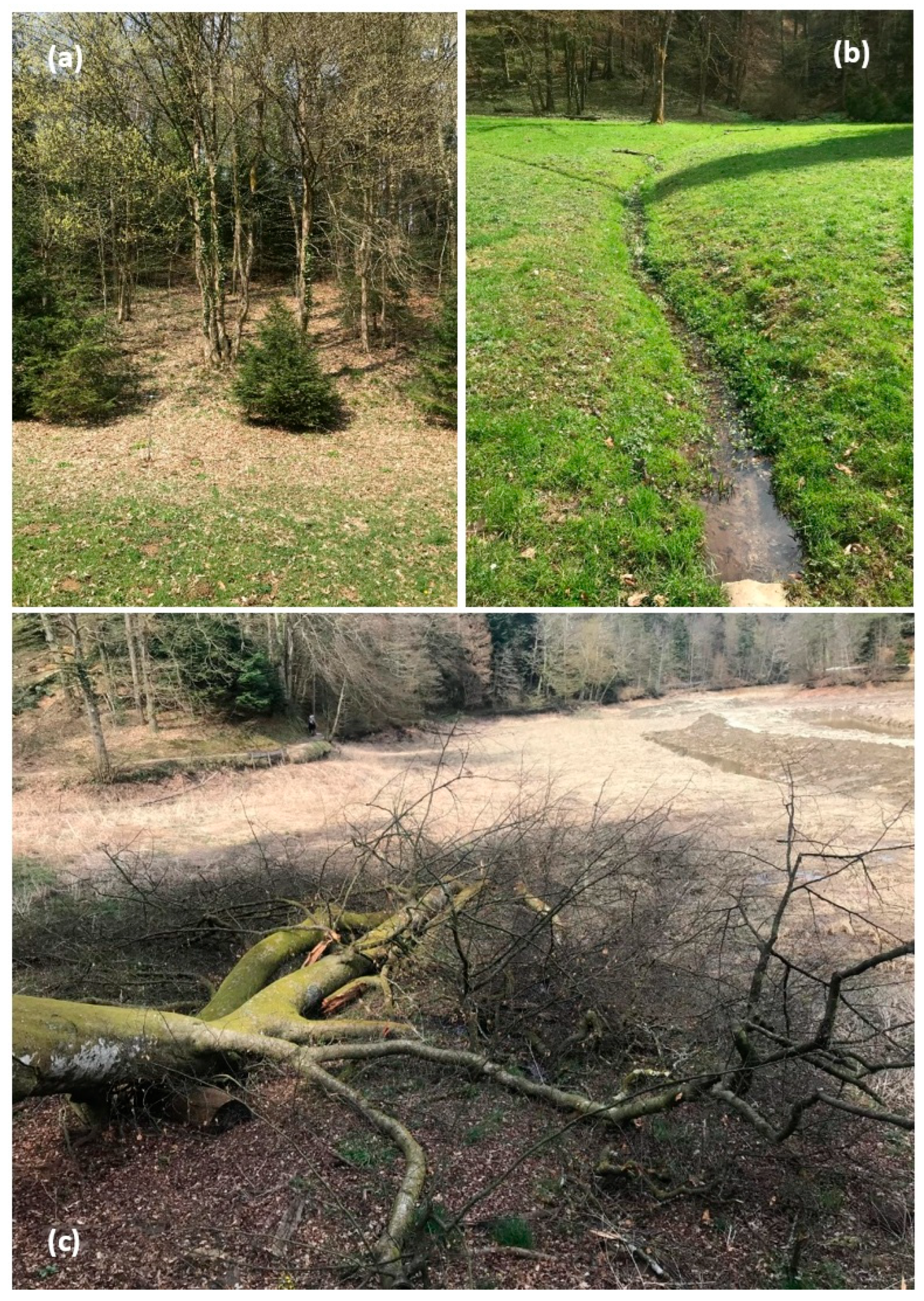
Further studies were later carried out to assess the lake’s condition. A comprehensive survey in 2007 evaluated the water quality and proposed measures for ecological restoration [22]. In 2019, additional investigations of the sediment thickness, composition, and water chemistry revealed sediment layers ranging in thickness from 1.4 to 2.7 m, corresponding to a total volume of 238,095 m3. The accumulated material was predominantly organic clay rich in plant residues (Figure 2), emitting a strong odour and containing some sand. As a consequence, the effective volume of the lake had been reduced by approximately 60% compared to its original capacity [4].

2.2. Geology of the Trakošćan Lake Catchment

The lake itself is located on alluvial deposits, which cover impermeable deposits of Lower Miocene age (M12 in Figure 3), as part of the Maceljska Formation, which according to Aničić and Juriša (1985) [23] corresponds to sandstone and clay deposits of predominantly silicate composition. In the Interpreter of the Basic Geological Map of Yugoslavia, Republic of Croatia, Rogatec M1:100,000, this formation is divided into the Vučji Jarek segment, which is made up of fine-grained glauconite sandstones, and the Čemernica segment, which consists of sandstone deposits of mainly tidal origin with glauconite and marl deposits [23,24] (Figure 3). The deposits are about 300 to 350 m thick.

3. Methods and Techniques of Analysis

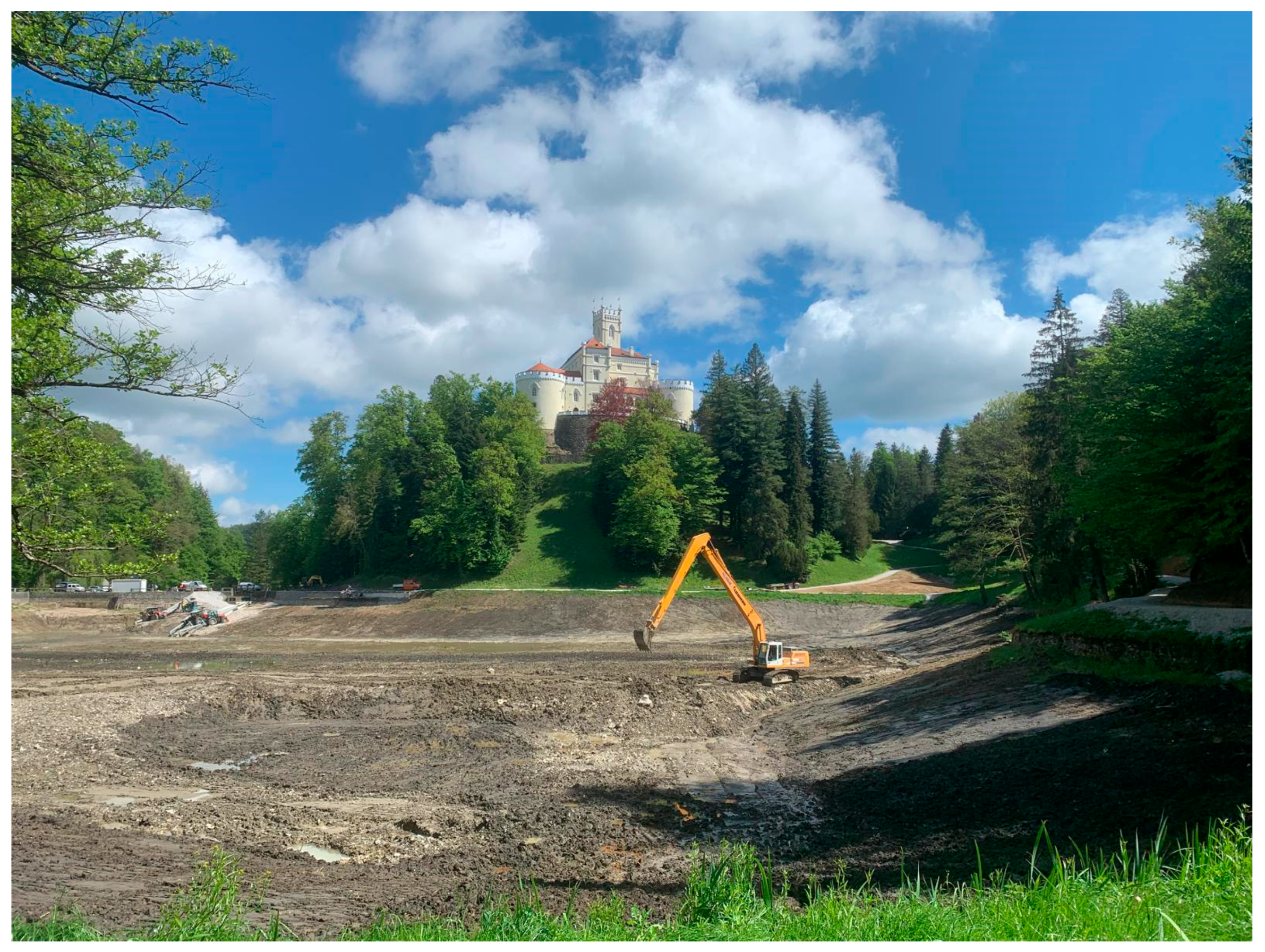
After the sediment was removed from the lake (Figure 4), it was temporarily deposited in nearby forest areas with the aim of determining its composition and a plan for its permanent disposal. Therefore, the goal of this research was to get a concrete insight into the chemical composition of the sediment with the purpose of its eventual use in agricultural production as a possible supplement to increase the quality of arable land. For this reason, an extensive qualitative geochemical and agrochemical analysis of the sediment composition was conducted for the first time, which includes indicators of the pH values, the amount of organic matter and carbon, total nitrogen, available phosphorus and potassium, the amount of carbonates, and the presence of metals, metalloids, and non-metals, of which certain elements such as As, Cd, Hg, and Pb are toxic. Electrochemical, spectrophotometric, and titration methods were used along with three techniques of atomic absorption spectrometry, namely: flame atomic absorption spectroscopy (FAAS), graphite furnace atomic absorption spectroscopy (GFAAS), and flow injection hydride generation atomic absorption spectrometry (FIAS).

3.1. Sampling and Laboratory Preparation of Lake Sediment

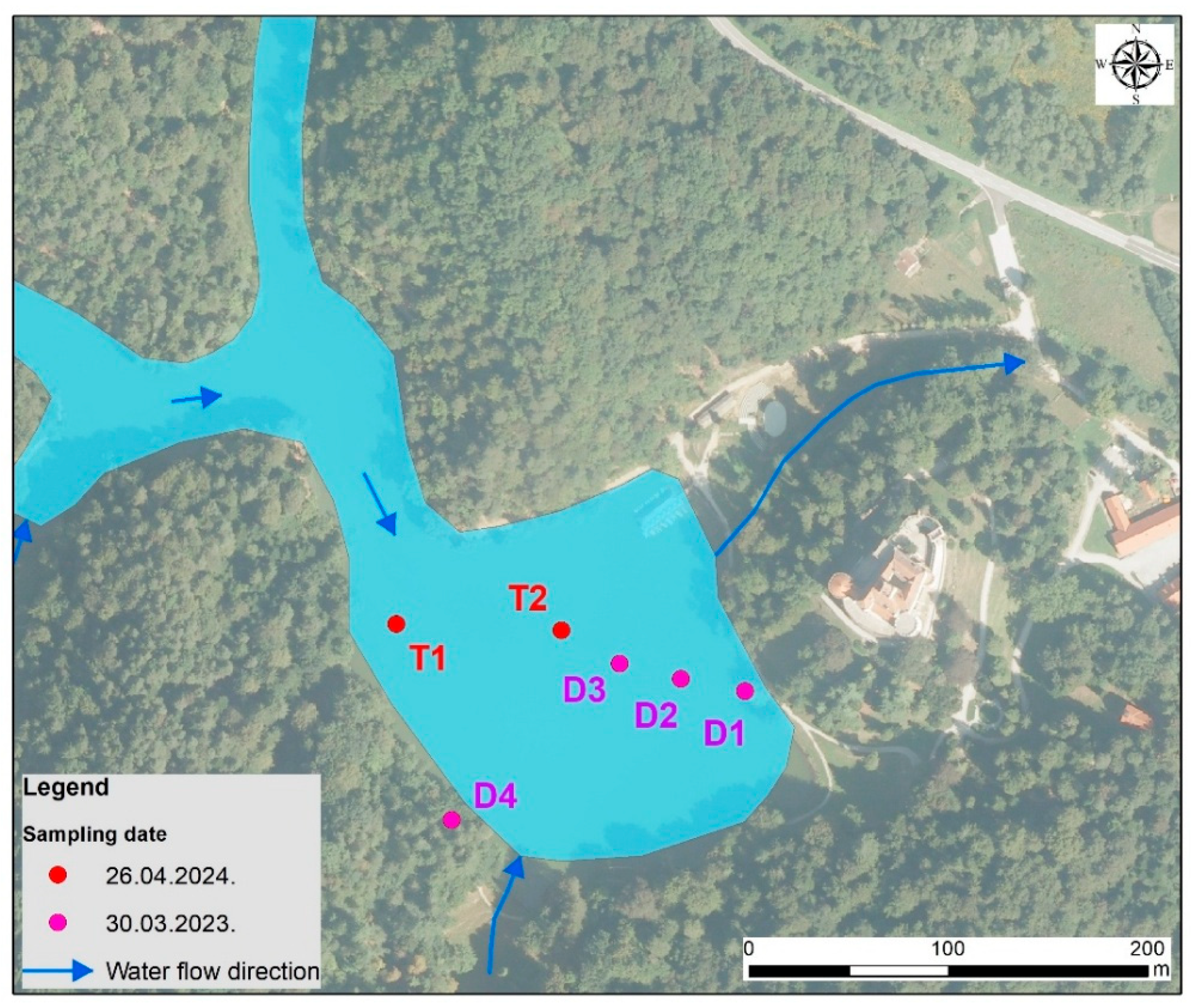
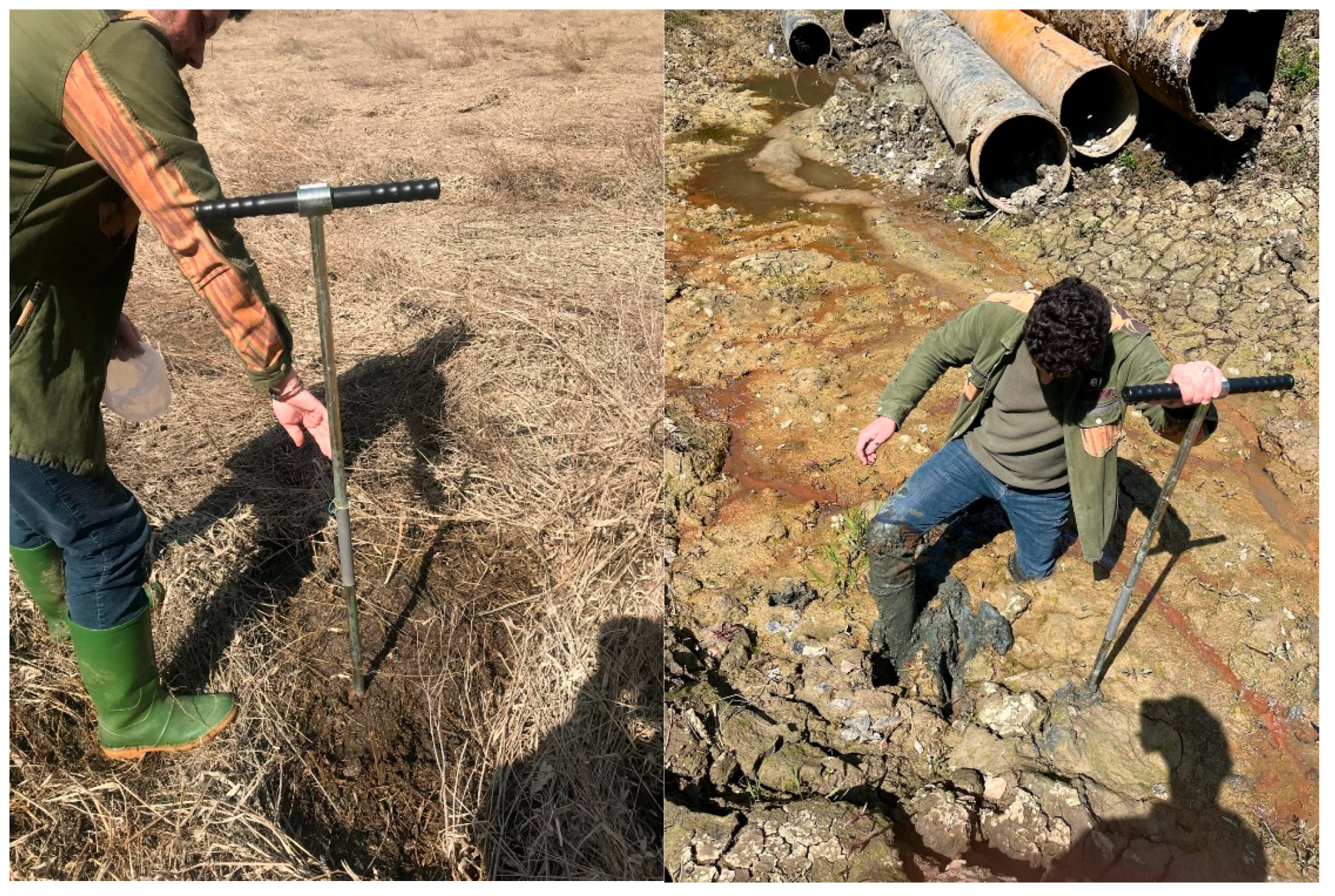
The lake sediment samples were first taken on 30 March 2023, when Lake Trakošćan was drained, and then on 26 April 2024. when the sediment was removed (Figure 5). During the first sampling, the surface layer of the lake sediment was sampled at three location point (D1–D3) with three different depths, from 0 to 20 cm, from 20 to 40 cm, and from 40 to 60 cm, while the fourth location point was the soil along the edge of the forest (D4) as shown in Figure 6. During the second sampling, the lake sediment was sampled from the surface of the undisturbed part of the lake (T1) and from the bottom at a depth of four meters (T2) where all sediment was removed (Figure 6). Upon arrival at the laboratory, the sediment was transferred to plastic trays for air drying at room temperature. It was then ground in an agate mill and sieved through a stainless-steel sieve with a mesh size of 2 mm.

3.2. Laboratory Sediment Analyses

A certain amount of sediment samples was weighed into Teflon vessels for microwave digestion on an analytical electronic KERN balance (Kern & Sohn, Balingen-Frommern, Germany). Each sample was poured with 20 mL of aqua regia and a mixture of hydrochloric acid 34 to 37% (for trace analysis) and nitric acid 67 to 69% (for trace analysis) in a ratio of 3:1. The reagent blank was prepared in the same way. The samples in the Teflon vessels were properly closed and placed in the Speedwave XPERT microwave digestion system manufactured by Berghof, Eningen, Germany. After digestion, the samples in the vessels were left to cool and then filtered through a 90 mm Munktell blue ribbon filter and glass rapid filtration funnels into labelled 100 mL volumetric flasks. The remaining sediment in the vessels and on the filter paper was washed with deionised water, which was used to fill up the volumetric flasks to the mark after filtration. Ultrapure water, with a conductivity of 0.05 µS/cm, was obtained using a Millipore Direct-Q 3 UV device (Millipore, Molsheim, France).
Acid eluates of lake sediment samples were analysed using an AAnalyst 800 atomic absorption spectrometer manufactured by PerkinElmer, Shelton, CT, USA. The concentration of the following elements was determined: Cu, Cr, Zn, Mn, Fe, Mg, Ca, Na, K, Ag, In, Au, Pd, Pt, As, Se, Cd, Pb, Ni, Co, and Hg. Three different techniques were used: the elements Cu, Cr, Zn, Mn, Fe, Mg, Ca, Na, K, Ag, In, Au, Pd, and Pt were determined by the flame technique (FAAS), As, Se, Cd, Pb, Ni, and Co were determined by the graphite furnace technique (GFAAS), and Hg was determined by the hydride technique (FIAS). In the flame technique, compressed air was used as the oxidant, and acetylene 2.6 was used as the carrier gas. In the graphite technique, argon 5.0 was used, and the same was used for the hydride technique.
Standard solutions of precisely determined concentrations required for the calibration of the AAS device were prepared from certified reference standards Inorganic Ventures (Christiansburg, VA, USA) and PerkinElmer Pure concentrations of 1000 mg/L. When calibrating the device with a blank test, the reagent blank value was also loaded. For the analyses with the graphite furnace, matrix modifier solutions of Mg (Mg (NO3)2) 10,000 mg/L, NH4H2PO4 10%, and Pd solution (Pd (NO3)2 in 15% HNO3) 10,000 mg/L from PerkinElmer Pure were used. For the graphite method, the autosampler was rinsed with a 0.2% nitric acid solution prepared from 60% ultrapure nitric acid from Meck. For the analyses using the hydride technique, a 0.2% NaBH4 solution prepared from p.a. sodium borohydride and a 3% HCl solution prepared from 60% ultrapure hydrochloric acid from Merck were used.
The values of the results obtained with the atomic absorption spectrometer are expressed in mg/L (ppm) or µg/L (ppb). Given the weights of individual samples, the values obtained were converted to mg/kg of dry matter.
The pH value in water and in a 1M potassium chloride solution was determined on lake sediment samples using a Sension156 multimeter manufactured by HACH (Loveland, CO, USA), which was previously calibrated to the IUPAC standards of the same manufacturer of 4005 and 7000 pH units. The percentage of organic matter in the form of humus was also determined using the dichromate method. The humus concentration was measured using a HACH DR 5000 spectrophotometer (Hach Lange GmbH, Düsseldorf, Germany) at a wavelength of 585 nm. The amount of available phosphorus was determined using the blue phospho-molybdenum method with the same device at a wavelength of 680 nm. The amount of available potassium was determined using a PerkinElmer AAS using the flame emission technique. The results of the concentrations of plant-available phosphorus and potassium are expressed in mg/100 g. The percentage of carbonate in the sediment was determined by volumetric measurement using a Scheibler calcimeter. The amount of total nitrogen expressed in percentages was determined using the adapted Kjeldahl method on the KjelROC OPSIS Liquid Line device (Furulud, Sweden).

3.3. Statistical Analysis

All measured values were organised in Excel tables (Table 1 and Table 2, which are presented in full in the Results section), where basic statistical processing was performed (mean, median, minimum, and maximum values in sediment samples were calculated) in order to recognise the natural distribution, to more easily recognise significant deviations, and to make comparisons with the natural soil outside the lake (D4). This was also necessary for the purpose of comparing the measured values with the location-dependent mean values of the areas presented within the Geochemical Atlas of the Republic of Croatia [25] (which is presented in detail in the Discussion section).
R mode cluster analysis was used to process the results. It is a hierarchical technique that obtains the degree of similarity between individual variables from the correlation matrix. The result is most often displayed in the form of a dendrogram. R-mode cluster analysis is very often applied in the geosciences mainly for evaluation of origin of particular elements or compounds or/and their mutual geochemical affinity. If the variance–covariance matrix is used, the pair of variables with the largest positive covariance is selected as the most similar. If the matrix of correlation coefficients is used, the most similar pair are those with the largest positive correlation coefficient. Different clusters are expected if different measures of similarity are used in the analyses, origin, or affinity of natural or anthropogenic sources, or both. For our purpose, we used the second approach with the Ward method and Pearson r distribution, because this approach allows correlation between large and small quantities of particular compounds as variables in samples [26].

4. Results

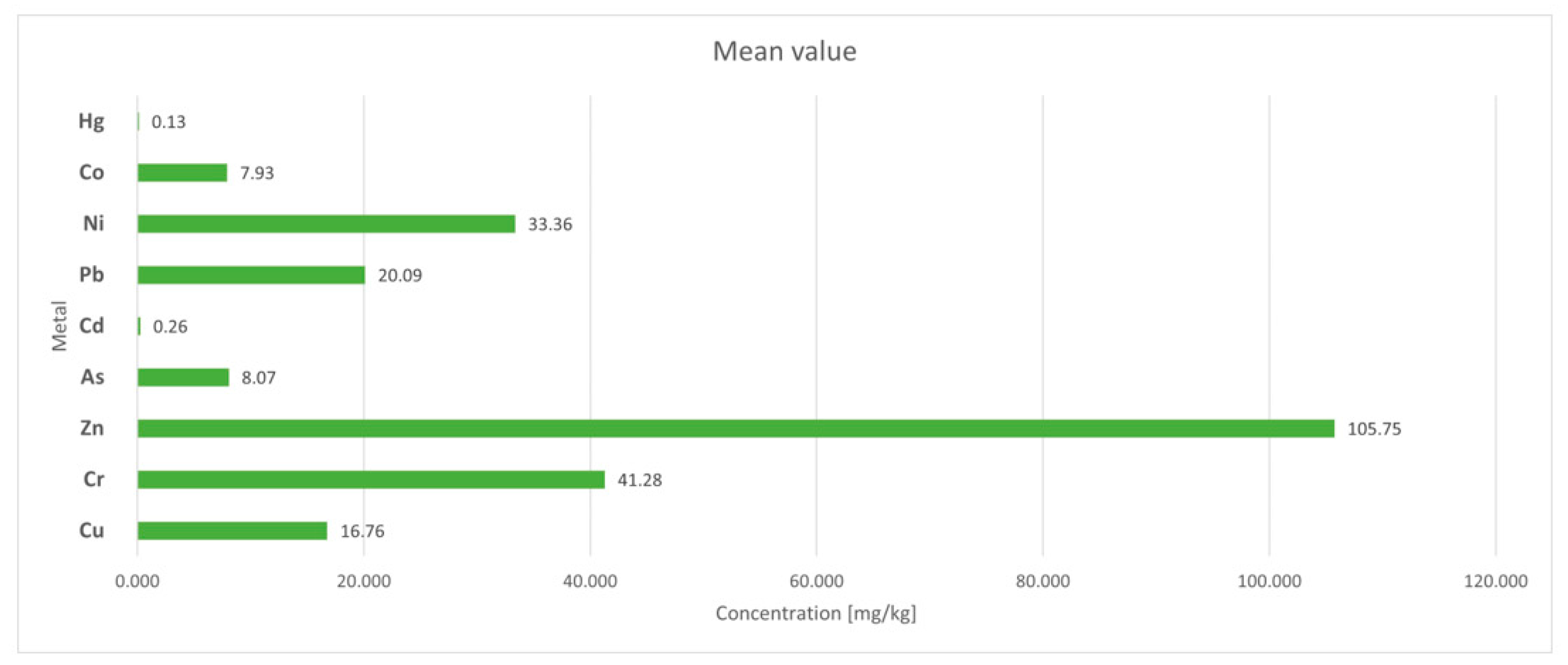
The results of geochemical and agrochemical analyses of the sediments of Trakošćan lake are presented in Table 1 and Table 2. In addition, the results of analyses of metals and metalloids in the lake sediment, as regulated by the Ordinance NN 71/2019 [19], are graphically presented in Figure 7.

5. Discussion

Based on the obtained results of the elemental composition and other indicators, humus, nutrients, and carbonates, the content of the discussion will address the distribution of individual parameters according to the depth of the lake sediment, the origin of the sediment, and its quality with regard to its utility value in agriculture and forestry. The pH value indicates a weakly acidic environment, which is a consequence of the decomposition of organic matter debris and the production of humic and probably carbonate acids. Additional studies and analyses should be undertaken to explain which scenario prevails. According to the surrounding lithology and soil characteristics, the present silicate minerals, mostly anions produced by hydrolysis of secondary minerals—clays originated from soils, and poorly soluble carbonates such as dolomite have insufficient acids neutralisation capability.

5.1. Distribution of Compounds and Elements Along the Depth of Sediments

At location T1, there is a higher content of organic components (humus, Corg, Ntot) in comparison with location T2, and the content of the carbonate component (CaCO3) is negligible in both locations (Figure 8). The dominant contents are the macrocomponents Mg, K, and Ca, while the Na content is negligible. The origin of the mentioned elements is related to the terrigenous contribution of soil leaching, which in its composition contains predominantly silicate minerals with a probably smaller contribution of poorly soluble carbonates. The shallower part of the sediment has a slightly higher content of Hg, Cd, As, Pb, Ni, Co, Cr, and Cu, unlike the deepest part where the Zn content is highest.
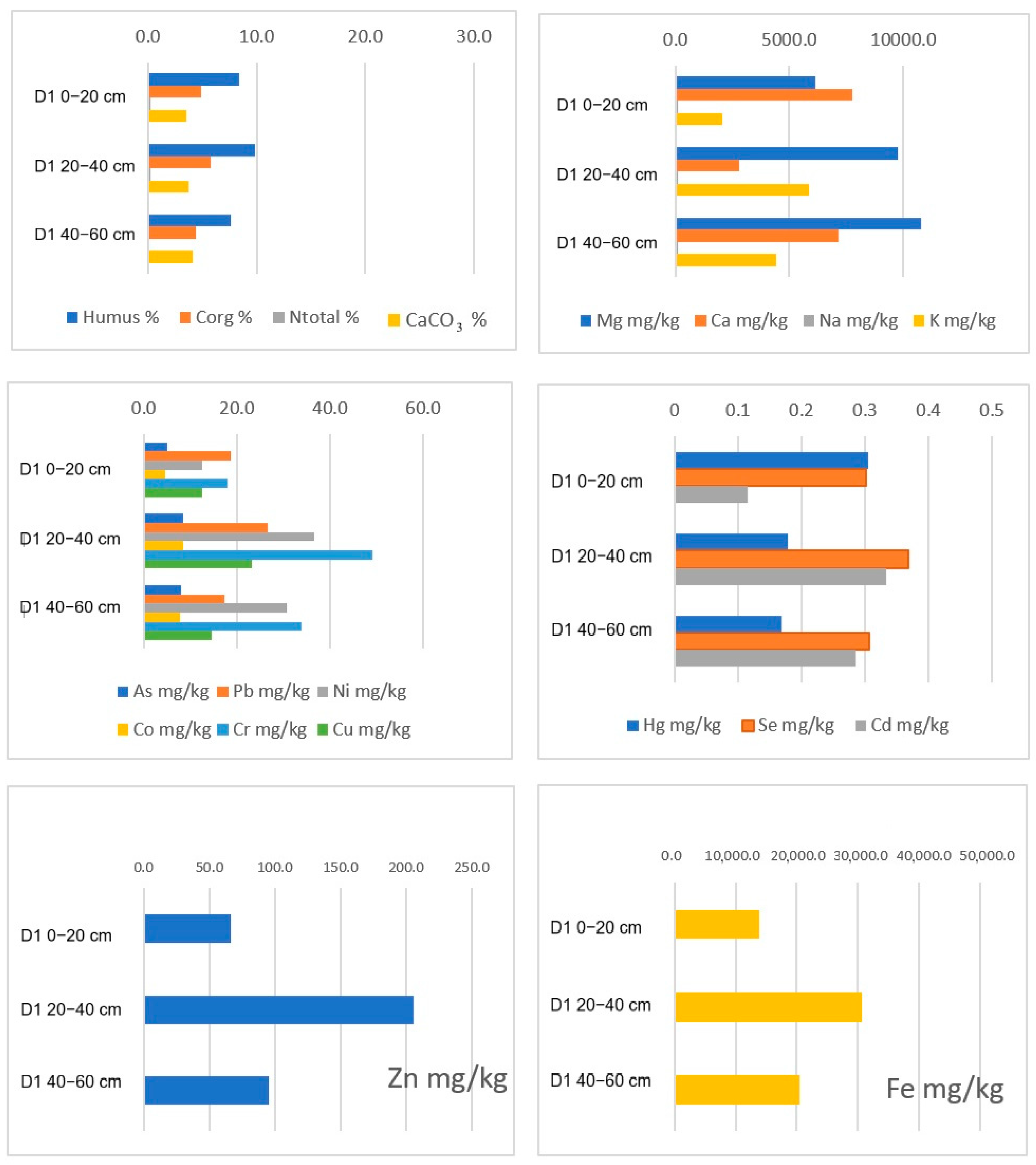
Location D1 is characterised by a similar distribution of parameters of organic origin, with the carbonate content being uniform (Figure 9). Along the profile, Mg, Ca, and K dominate, with the Mg and Ca content being highest in the shallowest part and K, most heavy metals, and Se in the central part of the profile. The exception is As, whose content gradually increases with depth.
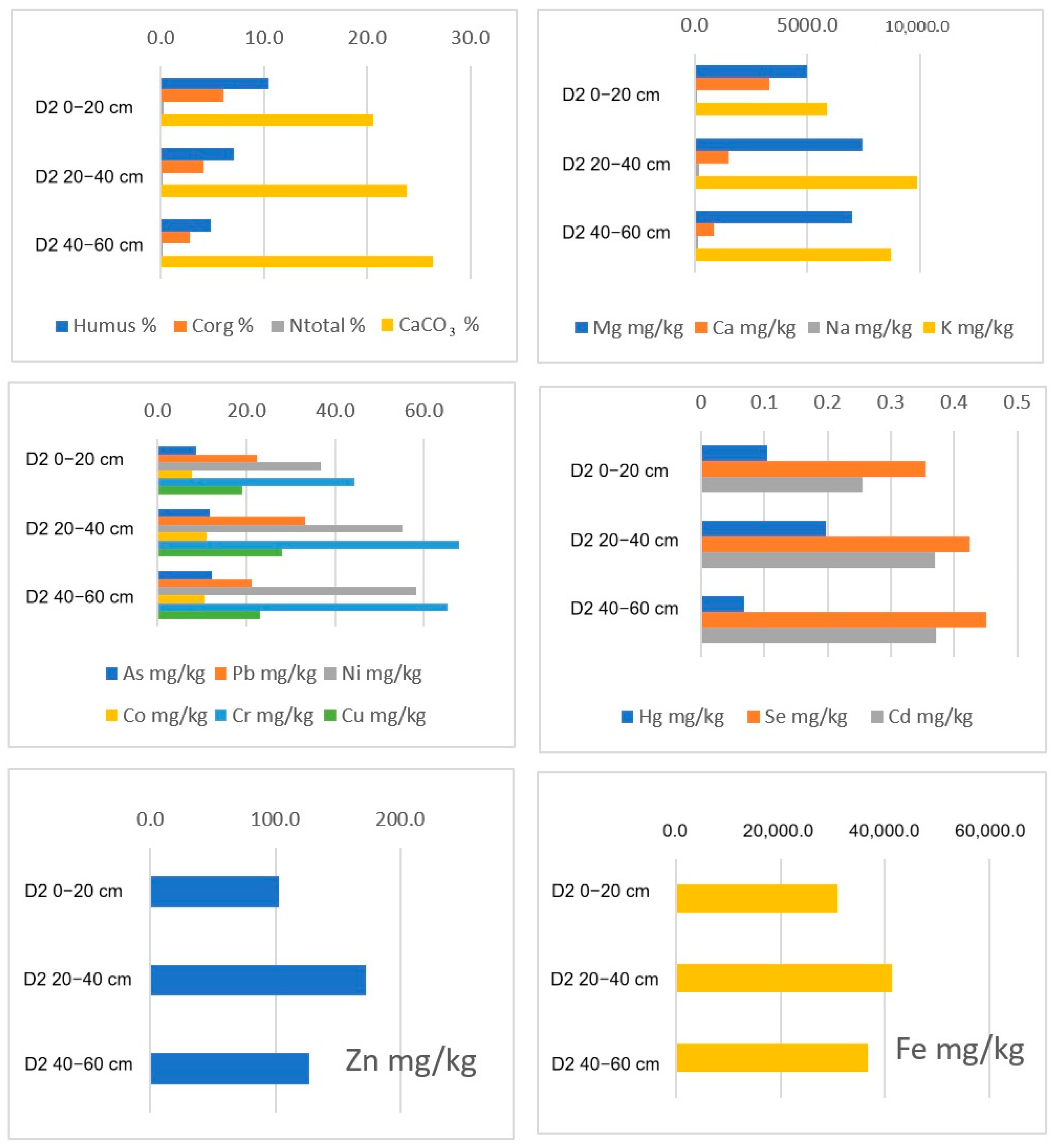
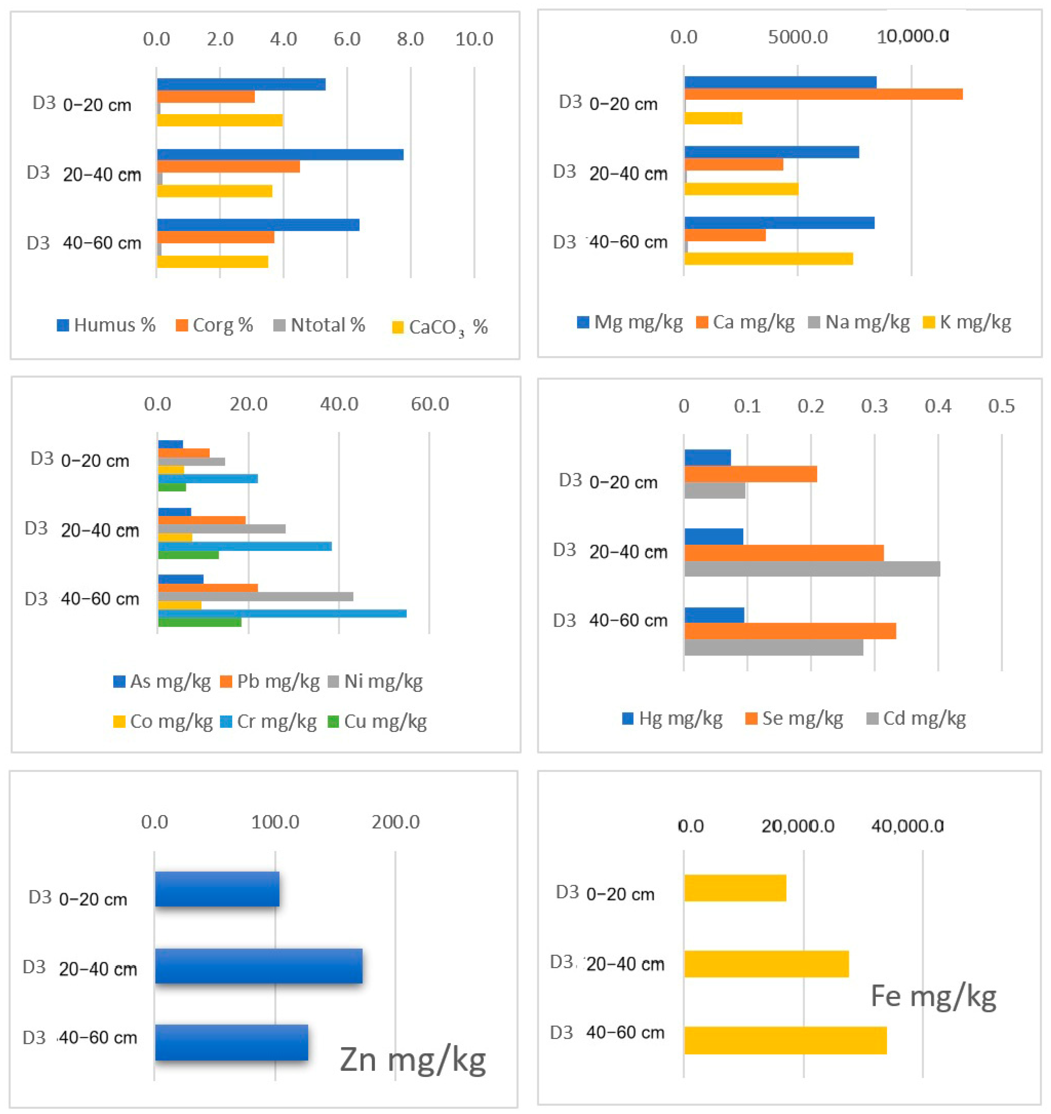
Considering the distribution of the measured parameters by depth at location D2 (Figure 10), a similar distribution of the content of organic components (humus, Corg) is repeated, except that the content of carbonate and total nitrogen is negligible. The content of As, Se, and heavy metals is highest in the central depth of 20 to 40 cm, including Zn and Fe. At location D3, the carbonate content slightly decreases with depth, and in the surface part, there is a higher concentration of Ca and Mg, while K has a lower concentration in the shallow part of sediment (Figure 11). The content of elements follows a trend of increasing element content with depth, while the content of Zn and Cd is highest in the central part of the profile.

5.2. Origin of Compounds and Elements

The origin of sediment compounds and elements and their mutual affinity are shown in the dendrogram (Figure 12). Within the dendrogram, two clusters are separated, lithogeochemical and geochemical, which represent the composition and probable anthropogenic contributions of the inflow area of Trakošćan Lake, rocks and organic detritus belonging to the forest area and park forest around Trakošćan Castle.
In the lithogeochemical cluster, two subclusters are distinguished, inorganic and organic. The inorganic cluster includes the pH value, calcium, magnesium, percentage of carbonates, phosphorus in the form of P2O5 (phosphorous pentoxide), and mercury. The organic cluster includes the percentage of humus, organic carbon, and total nitrogen. We can conclude that the origin of the mentioned components is the result of the weathering of rocks in the inflow area as well as the decomposition of organic matter from forest areas.
In the geochemical cluster, there are three subclusters in addition to K2O. The first is related to K2O and consists of Mn, Pb, and Co. The second is related to sodium and potassium and gathers Fe, Cr, Ni, As, Zn, Cd, and Cu. Here, it is possible to separate the elements Fe, Cr, Ni, and As and especially the three elements Zn, Cd, and Cu. The third cluster consists of Au, Pd, and Se. The concentrations of elements included in the cluster analysis are within the ranges for soils interpreted in the Geochemical Atlas of the considered area. Since the concentration of Zn in some samples exceeds the allowable values for agricultural lands, it is probably partly of anthropogenic origin. For other elements, anthropogenic influence cannot be excluded either, but to a lesser extent. All of the above clusters are the result of the washing of soil particles with silty and clay components from the immediate surface around the lake with possible anthropogenic input. Anthropogenic input can refer to various sources such as metal objects that gradually corrode or, for example, the mineral fertilisation of grassy areas, ornamental shrubs, and flower beds in the park surrounding Trakošćan Castle and the lake. The biological component should not be neglected here, since the lake was used as a fishpond and was often covered with algae. The remains of dead fish could also have contributed to the increase in certain indicators such as P2O5, As, Se, Hg, Zn, etc. The existence of multiple sub-clusters in the geochemical cluster is likely a consequence of the geochemical affinity of individual elements towards incorporation into individual secondary clay minerals, oxide, and sulphide amorphous formations, depending on the aeration of individual parts of the sediment, and the organic fraction of the sediment—humus. Since qualitative and semiquantitative X-ray diffraction analysis was not performed on the studied samples, a detailed interpretation is not reliable.

5.3. Sediment Quality

The mean pH value of the sediment in the water eluate is 6.46, and in a 1 M potassium chloride solution it is 6.16, which would classify it as almost neutral, or slightly acidic, according to the soil classification [27]. The mean percentage of humus in the sediment is 7.66%, which indicates that the sediment is highly supplied with humus, while the calculated amount of organic carbon is 4.44%. The mean amount of total nitrogen in the sediment is 0.17%, which is a good supply according to the aforementioned classification. The sediment contains phosphorus in the form of P2O5 at a concentration of 18.27 mg/100 g, which is also a good supply. Potassium in the form of K2O in the sediment is at a concentration of 19.43 mg/100 g, which is also a good supply for plants. The carbonate content is 2.59% on average (Table 1).
In order to interpret the results of the determination of metals and metalloids in the lake sediment (Table 2), it is necessary to compare them with the results from the Geochemical Atlas of the Republic of Croatia for the soils of central Croatia [25], for those elements that are available in the atlas (Table 3). Thus, the mean As concentration falls within the range and median value provided by the atlas. The concentration of Ca is in the range of the atlas values and below the median. The Cd concentration in the sediment is also in the range given by the atlas and corresponds to a median value. The concentration of Co also corresponds to the natural range but is slightly lower than the median, and the same is true for the concentrations of Cr and Cu in the sediment. Furthermore, the concentration of Fe is in the range of atlas values and close to its median. The sediment contains Hg in a concentration that corresponds to the Geochemical Atlas range. The concentration of K is also within the value of the given range but much lower than the median value. Mg is also in the concentration range provided by the atlas and is very close to the median. The value of Mn is in the natural range, although it is much lower than the median value. The concentration of Na is ten times below the lower limit of the atlas range. The mean concentration of Ni in the lake sediment is within the range provided and exactly corresponds to the median. Pb is in an amount that also corresponds to the range, but it is slightly lower than the median value. The last element that we can compare with the values from the Geochemical Atlas of the Republic of Croatia is Zn, and its concentration is in the given range for that metal although it is higher than the median value.
There are certain metals and metalloids prescribed by the Ordinance on the Protection of Agricultural Land from Contamination [19] (Table 4), and they are all present in certain concentrations in the lake sediment. Their concentrations were compared with the maximum allowable concentration (MAC) from the aforementioned ordinance.
Thus, Cu has an average of 16.760 mg/kg of total dry matter, Cr has 41.283 mg/kg d.w., Zn 105.754 mg/kg d.w., As 8.073 mg/kg d.w., Cd 0.260 mg/kg d.w., Pb 20.089 mg/kg d.w., Ni 33.359 mg/kg d.w., Co 7.927 mg/kg d.w., and Hg 0.125 mg/kg d.w. (Table 2). The concentrations of the prescribed metals and metalloids in the samples, according to the mean values from individual points and depending on the pH value of the sediment, do not exceed that maximum permitted by the regulations, which makes this sediment, according to the cited regulations, uncontaminated by these heavy and toxic metals.
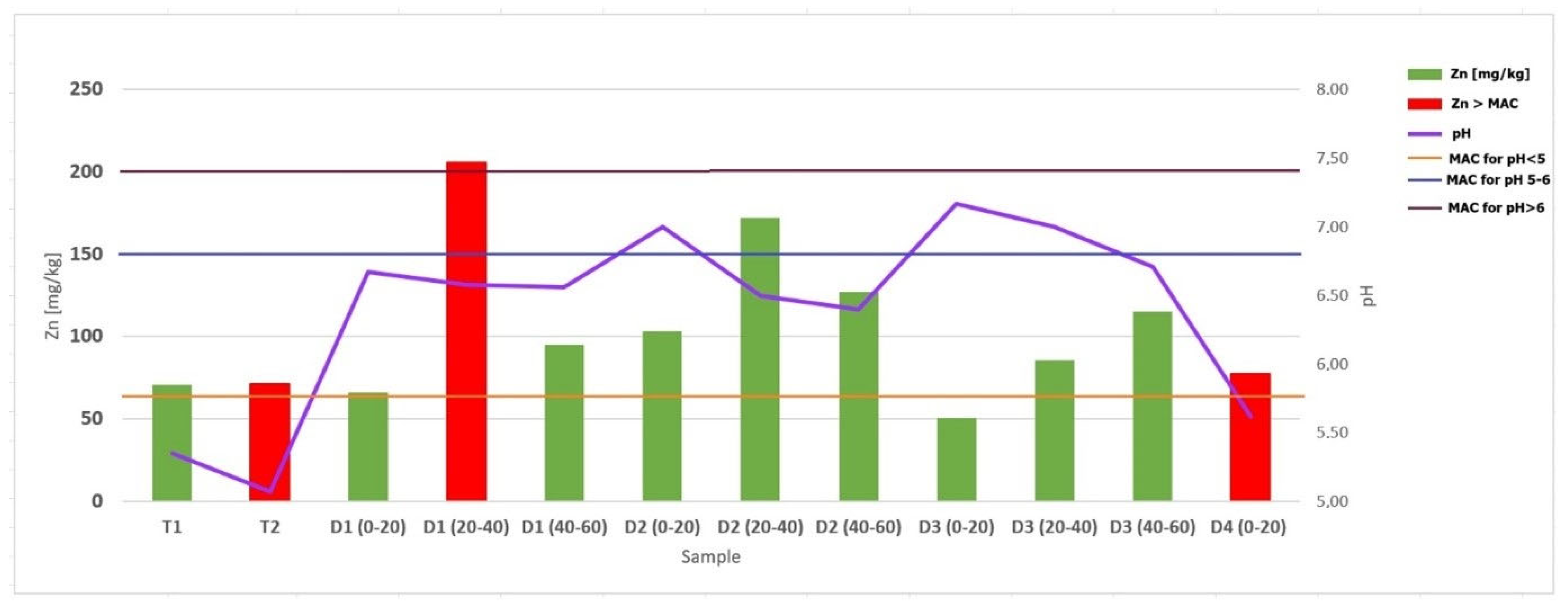
The value for Zn is interesting, which, in samples T2, D1 20–40 cm and D4, exceeds the maximum allowable concentration prescribed by the regulation (Figure 13), but the mean value of this element in the compound sediment samples is still below the prescribed maximum allowable concentration.

6. Conclusions

The implementation of the Trakošćan lake cleaning project significantly increased the volume of the reservoir for water intake by 500,000 m3, thus extending the life of the lake, i.e., slowing down the natural aging process of the aquatic ecosystem (eutrophication) and lake overgrowth. In this way, a positive impact on the biodiversity of the lake, the local community, visitors and tourists, and local associations is ensured. In addition, it contributes to improving the protection system against the harmful effects of water and reducing the risk of floods. After the revitalisation of the Trakošćan lake in early March 2025, the restoration of the fish stock began by returning indigenous species such as carp, and in the future, probably also perch and tench. This is crucial for maintaining biodiversity and creating a balance with sustainable fishing, and the return of other plant and animal species of the lake and the coast is expected.
The results of the analysis showed that the sediment has a slightly acidic character, is highly supplied with organic matter, is well supplied with nitrogen, phosphorus, and potassium, and contains carbonates. By comparing the mean values of the measured concentrations determined by the Ordinance on the Protection of Agricultural Land from Contamination for regulated elements, it is evident that they are below the maximum allowable concentrations, which means that the sediment of Trakošćan lake is not contaminated with these metals and metalloids. The mean values of the elements determined here compared with those provided by the Geochemical Atlas of the Republic of Croatia for soils indicate that the concentrations of the determined elements correspond to the natural range, except for the concentration of Hg, which is lower than the lowest limit for this metal in the soils of central Croatia.
The aim of this research was to provide evidence that the sediment from Trakošćan lake is of natural origin, thus harmless to the environment and suitable for disposal on agricultural land and, as such, represents a valuable resource, not waste. The results of the analysis lead to the conclusion that the sediment from Trakošćan lake will not have negative effects on the environment and soil on which it can be disposed, since the elements analysed do not exceed MAC. According to the analysed indicators, this lake sediment does not pose a chemical threat of contamination of the environment in which it is located. Analyses have also shown that the sediment can be used as a natural additive to arable soil with the purpose of improving its quality and increasing the yield of field crops, since it contains a good amount of nutrients that are present in a form accessible to plants and by which the sediment can enrich agricultural soil.

Author Contributions

S.Z.—sampling, preparation and laboratory analysis of the sediment, materials and methods, obtaining the results, preparing the tables, discussion on sediment quality; S.K.—geology and geochemistry in study area, geochemical and statistical interpretation of the results, graphical presentation of the results; D.O.—introduction, description of the study area and hydrology, conclusion; J.L.—introduction, geology of the study area, maps, graphical presentation of the results. All authors have read and agreed to the published version of the manuscript.

Funding

This research received no external funding.

Data Availability Statement

The original contributions presented in this study are included in the article. Further inquiries can be directed to the corresponding author.

Conflicts of Interest

The authors declare that there are no conflicts of interest.

References

  1. Pannard, A.; Souchu, P.; Chauvin, C.; Delabuis, M.; Gascuel-Odoux, C.; Jeppesen, E.; Gross, E.M. Why are there so many definitions of eutrophication? Ecol. Monogr. 2024, 94, e1616. [Google Scholar] [CrossRef]
  2. Vorosmarty, C.J.; Meybeck, M.; Fekete, B.; Sharma, K.; Green, P.; Syvitski, J.P.M. Anthropogenic sediment retention: Major global impact from registered river impoundments. Glob. Planet. Change 2003, 39, 169–190. [Google Scholar] [CrossRef]
  3. Verstraeten, G.; Bazzoffi, P.; Lajczak, A.; Rãdoane, M.; Rey, F.; Poesen, J.; de Vente, J.; Reservoir and Pond Sedimentation in Europe; Physical and Regional Geography Research Group; Katholieke Universiteit Leuven. Soil Erosion in Europe; Boardman, J., Poesen, J., Eds.; John Wiley & Sons: Hoboken, NJ, USA, 2006. [Google Scholar]
  4. Oskoruš, D.; Leskovar, K.; Pavlić, K. Parametric methods for assessing the production of suspended sediment and its deposition in artificial lakes—An example of Lake Trakošćan, Croatia. In Proceedings of the EGU General Assembly 2023, Vienna, Austria, 24–28 April 2023; p. EGU23-13546. [Google Scholar] [CrossRef]
  5. Oskoruš, D.; Leskovar, K.; Pavlić, K.; Tošić, I. Assessing the long-term production of suspended sediment and the climate changes impact on its deposition in artificial lakes–a case study of Lake Trakošćan, Croatia. Climate 2023, 11, 167. [Google Scholar] [CrossRef]
  6. Magnuszewski, A.; Moran, S.; Yu, G. Modelling lowland reservoir sedimentation conditions and the potential environmental consequences of dam removal: Wloclawek Reservoir, Vistula River, Poland. In Sediment Dynamics for a Changing Future, Proceedings of the ICCE Symposium Held at Warsaw University of Life Sciences—SGGW, Warsaw, Poland, 14–18 June 2010; IAHS Publ.: Oxford, UK, 2010; p. 337. [Google Scholar]
  7. Kelderman, P.; Yang, X.; Drossaert, W.M.E. Sediment pollution with respect to heavy metals and organic micropollutants in the city canals of Delft (The Netherlands)—Assessment of a data base of 188 sediment stations. In E-Water; Official Publication of the European Water Association (EWA): Hennef, Germany, 2005. [Google Scholar]
  8. Kelderman, P.; Drossaert, W.M.E.; Zhang, M.; Galione, L.S.; Okonkwo, L.C.; Clarisse, I.A. Pollution assessment of the canal sediments in the city of Delft (the Netherlands). Water Res. 2000, 34, 936–944. [Google Scholar] [CrossRef]
  9. Lawrence, P.; Atkinson, E. Deposition of fine sediments in irrigation canals. Irrig. Drain. Syst. 1998, 12, 371–385. [Google Scholar] [CrossRef]
  10. Maggi, I.; Maraga, F.; Ottone, C. Erosive rains related to in-channel sediment delivery in a small Alpine basin (North-Western Italy). In Proceedings of the 9th Conference of the European Network of Experimental and Representative Basins (ERB), Demänovská Dolina, Slovakia, 25–28 September 2002; pp. 91–99. [Google Scholar]
  11. Smith, V.H.; Tilman, G.D.; Nekola, J.C. Eutrophication: Impacts of excess nutrient inputs on freshwater, marine, and terrestrial ecosystems. Environ. Pollut. 1999, 100, 179–196. [Google Scholar] [CrossRef] [PubMed]
  12. Savić, R.; Pantelić, S.; Belić, A.; Belić, S. Teški metali u sedimentima melioracionih kanala. Zb. Rad. Građevinskog Fak. 2005, 14, 260–265. [Google Scholar]
  13. Savić, R.; Josimov-Dunđerski, J.; Belić, A.; Ondrašek, G.; Letić, L.; Nikolić, V. Monitoring Kvalitata Vode i Sedimenta Manjih Vodotoka u Vojvodini—Primjer Vodotoka Tatarnica. 2025. Available online: http://doisrpska.nub.rs/index.php/agroznanje/article/viewFile/2293/2202 (accessed on 29 August 2025).
  14. Leko-Kos, M. Nastanak i Pokretljivost Sedimenta Onečišćenog Teškim Metalima u Melioracijskim Kanalima Ravničarskih Područja. Ph.D. Thesis, Sveučilište Josipa Jurja Strossmayera u Osijeku, Građevinski i arhitektonski fakultet Osijek, Osijek, Croatia, 2019. [Google Scholar]
  15. Hrvatske Vode. Jezero Trakošćan Zapunjeno Vodom. Available online: https://www.voda.hr/hr/novost/jezero-trakoscan-zapunjeno-vodom (accessed on 8 September 2025).
  16. Zakon o Gospodarenju Otpadom, NN 84/2021, 142/2023. Available online: https://www.zakon.hr/z/2848/zakon-o-gospodarenju-otpadom (accessed on 8 September 2025).
  17. Javna Ustanova “Priroda Varaždinske Županije”. Trakošćan. Available online: https://priroda-vz.hr/podrucja/trakoscan/ (accessed on 10 September 2025).
  18. Lemière, B.; Gebert, J.; Wijdeveld, A. The CE white paper. In Proceedings of the SedNet WG Circular Economy WGCE7, Delft, The Netherlands, 5 July 2022. [Google Scholar]
  19. Ministarstvo Poljoprivrede. Pravilnik o Zaštiti Poljoprivrednog Zemljišta od Onečišćenja NN 71/2019. Available online: https://narodne-novine.nn.hr/clanci/sluzbeni/2019_07_71_1507.html (accessed on 8 September 2025).
  20. Tanocki, Z.; Crljenko, I. Jezera Hrvatske; Školska knjiga: Zagreb, Hrvatska, 2011. [Google Scholar]
  21. Geokon-Zagreb, d.d. Geotechnical Study of a Survey of the Thickness and Composition of Sediment and Water Quality in Lake Trakošćan; Geokon-Zagreb d.d.: Zagreb, Croatia, 2019. [Google Scholar]
  22. Kerovec, M. Studija Utvrđivanja Stanja Vode u Jezeru Trakošćan sa Programom Mjera za Njegovu Sanaciju i Revitalizaciju; Studeni: Zagreb, Croatia, 2007. [Google Scholar]
  23. Aničić, B.; Juriša, M. Osnovna Geološka Karta SFRJ 1:100 000—Tumač List Rogatec L 33 68; Geološki Zavod: Ljubljana, Slovenia, 1985. [Google Scholar]
  24. Avanić, R.; Pavelić, D.; Pecskay, Z.; Miknić, M.; Tibljaš, D.; Wacha, L. Tidal deposits in the Early Miocene Central Parathethys: The Vučji Jarek and Čemernica members of the Macelj formation (NW Croatia). Geol. Croat. 2021, 74, 41–56. [Google Scholar] [CrossRef]
  25. Halamić, J.; Miko, S. Geokemijski atlas Republike Hrvatske; Hrvatski Geološki Institut: Zagreb, Hrvatska, 2009. [Google Scholar]
  26. Statistica; Software Version 7; StatSoft: Tulsa, OK, USA, 2005.
  27. Ćosić, T.; Čoga, L.; Pavlović, I.; Patek, M.; Slunjski, S. Materijali za Vježbe iz Ishrane Bilja; Zavod za ishranu bilja, Agronomski fakultet Sveučilišta u Zagrebu: Zagreb, Hrvatska, 2007. [Google Scholar]
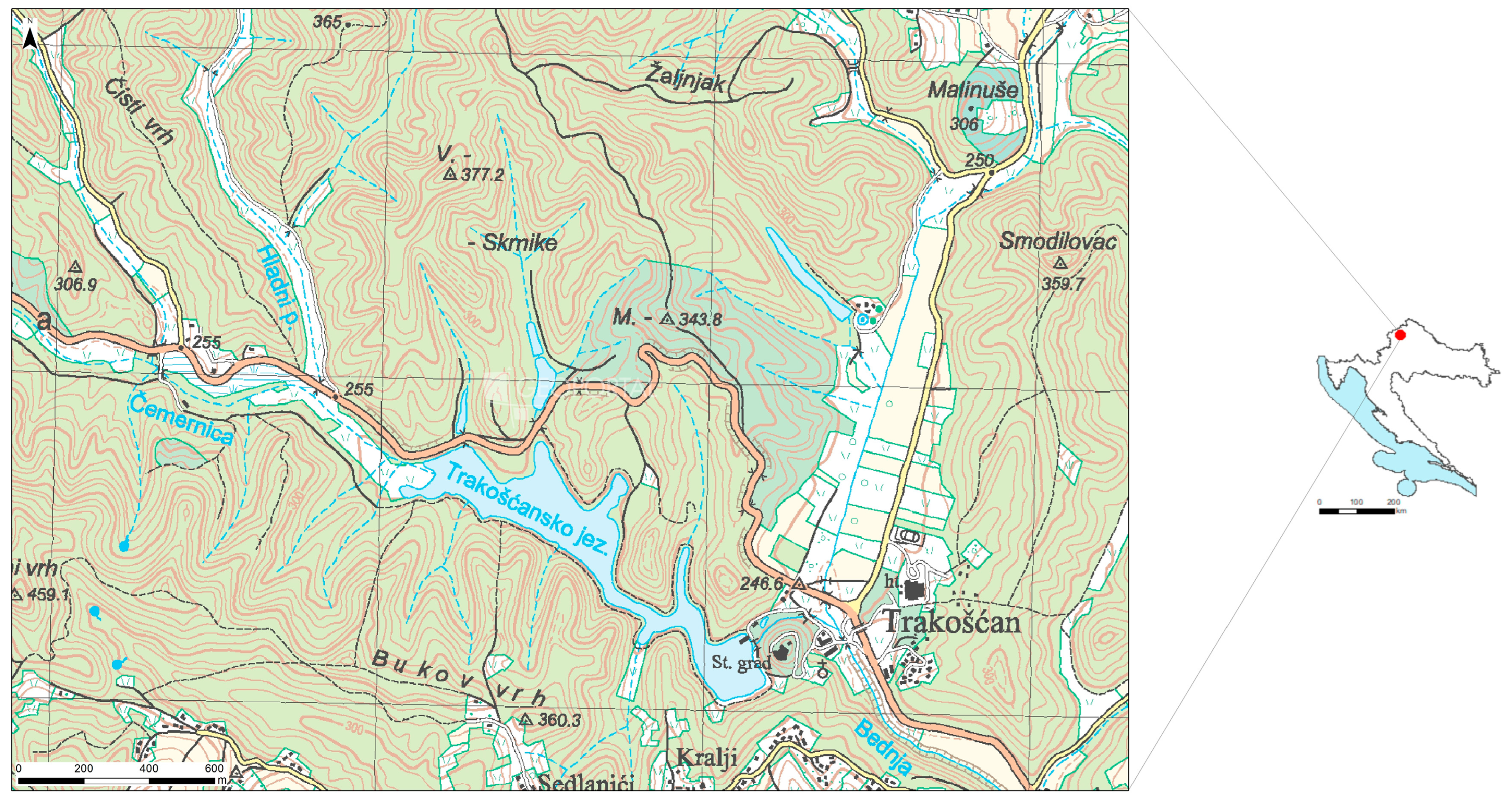
Figure 1. Location of the Trakošćan lake on the topographic map of the Republic of Croatia.
Water 17 03055 g001
Figure 2. Entry of biological material and water into the lake Trakošćan: (a) forest leaves, (b) stream carrying material, and (c) a tree fell directly into the lake.
Water 17 03055 g002
Figure 3. Excerpt from the Basic Geological Map Republic of Croatia 1:100,000 showing the location of Lake Trakošćan [23].
Water 17 03055 g003
Figure 4. The drained Trakošćan Lake with dredging works next to Trakošćan Castle, April 2024.
Water 17 03055 g004
Figure 5. Spatial representation of sampling points in Trakošćan lake.
Water 17 03055 g005
Figure 6. Sampling of lake sediment from different depths in March 2023 (left) and sampling of lake sediment from different depths in April 2024 (right).
Water 17 03055 g006
Figure 7. Graphical representation of the concentration of metals included in Ordinance NN 71/2019.
Water 17 03055 g007
Figure 8. Distribution of elements, humus, organic carbon, total nitrogen, and CaCO3 along the depth of locations T1 and T2.
Water 17 03055 g008
Figure 9. Distribution of elements, humus, organic carbon, total nitrogen and CaCO3 along the depth of location D1.
Water 17 03055 g009
Figure 10. Distribution of elements, humus, organic carbon, total nitrogen, and CaCO3 along the depth of location D2.
Water 17 03055 g010
Figure 11. Distribution of elements, humus, organic carbon, total nitrogen, and CaCO3 along the depth of location D3.
Water 17 03055 g011
Figure 12. Dendrogram of geochemical origin and affinity of particular compounds and elements in lake sediments.
Water 17 03055 g012
Figure 13. Concentration of zinc in different sediment depths related to the pH value and maximum allowable concentration.
Water 17 03055 g013
Table 1. Results of pH value and potential nutrient analyses in lake sediment.
TRAKOŠĆAN LAKEpH (KCl)pH (Water)Humus %Corg %Total N %P2O5 mg/100 gK2O mg/100gCaCO3 %
T1 26.04.24. surface5.105.3513.677.930.233.058.360.34
T2 26.04.24. bottom on 4 m4.295.072.851.650.0930.4811.700.33
D1 0–20 30.03.23.6.466.678.434.890.2245.5612.603.51
D1 20–406.416.589.875.720.2416.9623.023.75
D1 40–606.386.567.634.430.1522.3013.464.08
D2 0–206.627.0010.446.060.2511.8320.612.72
D2 20–406.136.507.064.090.1711.7323.881.47
D2 40–606.146.404.802.780.1315.9726.341.14
D3 0–206.997.175.333.090.1213.1610.843.97
D3 20–406.717.007.784.510.1713.4015.083.64
D3 40–606.576.716.393.710.1416.4920.063.50
D4 0–20 (near forest)4.885.624.822.800.142.6927.760.38
Mean value without D46.166.467.664.440.1718.2719.432.59
Median without D46.416.587.634.430.1715.9715.083.50
min. value4.295.072.851.650.093.058.360.33
max. value6.997.1713.677.930.2545.5626.344.08
Table 2. Results of analyses of metals, metalloids, and potentially toxic elements in lake sediment with the maximum allowable concentration marked in red.
TRAKOŠĆAN LAKECu [mg/kg]Cr [mg/kg]Zn [mg/kg]Mn [mg/kg]Fe
[mg/kg]
Mg [mg/kg]Ca
[mg/kg]
Na [mg/kg]K
[mg/kg]
Ag [mg/kg]In [mg/kg]
T1 26.04.24. surface15.02331.17470.892236.62021,910.803708.92846.948110.613056.338<DL<DL
T2 26.04.24. bottom on 4 m10.72828.73871.408194.17521,286.413466.02238.3562.9131980.583<DL<DL
D1 0–20 30.03.23.12.50017.96366.389322.68513,898.156157.417768.51986.0652069.444<DL<DL
D1 20–4023.17149.073205.756411.22030,575.619780.492809.756118.5375853.659<DL<DL
D1 40–6014.59733.93494.834309.47920,412.3210,758.297137.44189.14436.019<DL<DL
D2 0–2018.98644.378103.134417.51230,967.745000.003321.659112.9035852.535<DL<DL
D2 20–4027.95967.959172.194477.55141,377.557448.981484.694218.3679852.041<DL<DL
D2 40–6023.00065.286127.143488.09536,752.386976.19858.095158.5718714.286<DL<DL
D3 0–206.30822.20550.872293.33317,061.548435.9012,225.64193.592564.103<DL<DL
D3 20–4013.49338.37385.598376.07727,645.937703.354344.498100.9575019.139<DL<DL
D3 40–6018.59355.025115.075411.55833,984.928366.833582.915153.7697432.161<DL<DL
D4 0–20 (near forest)10.56736.59877.474446.90721,546.395051.55476.289121.0313726.804<DL<DL
Mean value without D416.76041.283105.754358.02826,897.587072.944056.229118.6715166.392<DL<DL
Median without D415.0238.3794.83376.0827,645.937448.983321.66110.615019.14<DL<DL
min. value6.3117.9650.87194.1813,898.153466.02238.3562.911980.58<DL<DL
max. value27.9667.96205.76488.1041,377.5510,758.2912,225.64218.379852.04<DL<DL
TRAKOŠĆAN LAKEAu [mg/kg]Pd [mg/kg]Pt [mg/kg]As [mg/kg]Se [mg/kg]Cd [mg/kg]Pb [mg/kg]Ni [mg/kg]Co [mg/kg]Hg [mg/kg]
T1 26.04.24. surface8.1224.601<DL8.120.3610.20618.01525.0706.5510.078
T2 26.04.24. bottom on 4 m7.1845.485<DL3.5480.3450.13710.42825.8017.3850.017
D1 0–20 30.03.23.5.0934.444<DL5.0820.3010.11518.76512.5324.5190.305
D1 20–4011.9516.098<DL8.3790.3690.33426.67936.4988.5290.179
D1 40–606.5884.976<DL8.1030.3060.28517.33330.7637.8310.169
D2 0–207.7424.654<DL8.5880.3540.25622.24136.6967.6010.104
D2 20–4010.5616.531<DL11.8150.4250.36933.32855.20410.9970.198
D2 40–609.5245.714<DL12.1320.4510.37121.21658.33310.6070.068
D3 0–201.8462.923<DL5.5320.2100.09711.47314.7905.910.074
D3 20–405.4073.684<DL7.3670.3140.40319.37428.1827.6380.093
D3 40–607.8392.864<DL10.1340.3340.28222.12743.0759.630.095
D4 0–20 (near forest)0.8251.340<DL7.6370.2450.14418.60429.8818.2860.006
Mean value without D47.4424.725<DL8.0730.3430.26020.08933.3597.9270.125
Median without D47.744.65-8.120.350.2819.3730.767.640.10
min. value1.852.860.003.550.210.1010.4312.534.520.02
max. value11.956.530.0012.130.450.4033.3358.3311.000.31
Table 3. Comparison of the analytical results with values from the Geochemical Atlas.
ElementSediment Concentration [mg/kg] d.w.Geochem. Atlas Range [mg/kg] [%]Median
[mg/kg] [%]
As8.0731.8–59 mg/kg8.4 mg/kg
Ca4056.2290.07–26.79%0.52%
Cd0.2600.2–9.4 mg/kg0.2 mg/kg
Co7.9273–36 mg/kg11 mg/kg
Cr41.28328–524 mg/kg74 mg/kg
Cu16.7603–248 mg/kg19 mg/kg
Fe26,897.580.6–6.94%2.96%
Hg0.1250.005–4.535 mg/kg0.05 mg/kg
K5166.3920.33–3.28%1.6%
Mg7072.940.23–7.52%0.67%
Mn358.028131–5619 mg/kg551 mg/kg
Na118.6710.11–3.21%0.79%
Ni33.35912–427 mg/kg33 mg/kg
Pb20.08914–217 mg/kg27 mg/kg
Zn105.75428–477 mg/kg73 mg/kg
Table 4. Maximum allowable concentrations of certain metals for agricultural land in Croatia.
Element mg/kgpH Value
<55–6>6
Cd11.52
Cr4080120
Cu6090120
Hg0.511.5
Ni305075
Pb50100150
Zn60150200
As152530
Co305060
Disclaimer/Publisher’s Note: The statements, opinions and data contained in all publications are solely those of the individual author(s) and contributor(s) and not of MDPI and/or the editor(s). MDPI and/or the editor(s) disclaim responsibility for any injury to people or property resulting from any ideas, methods, instructions or products referred to in the content.