


Past and Future Storm-Driven Changes to a Dynamic Sandy Barrier System: Outer Cape Cod, Massachusetts

 , ,
, ,  , , , , , and
Abstract
1. Introduction
1.1. Background Information
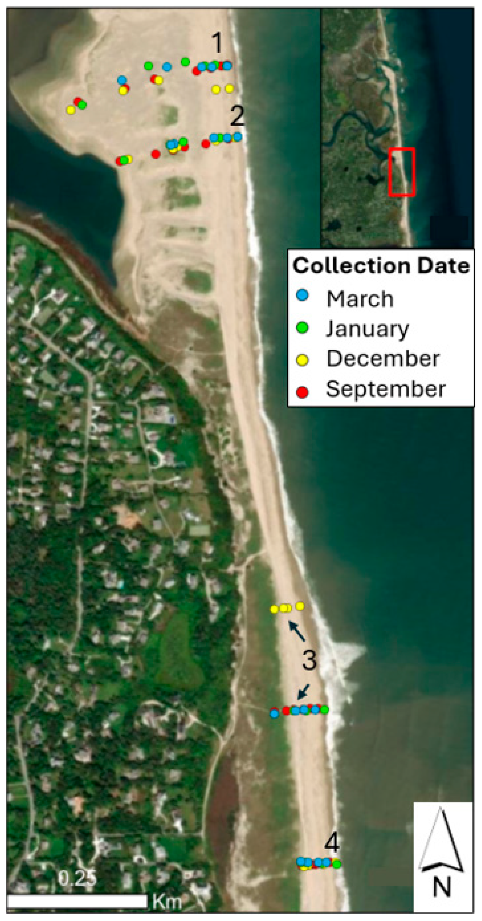
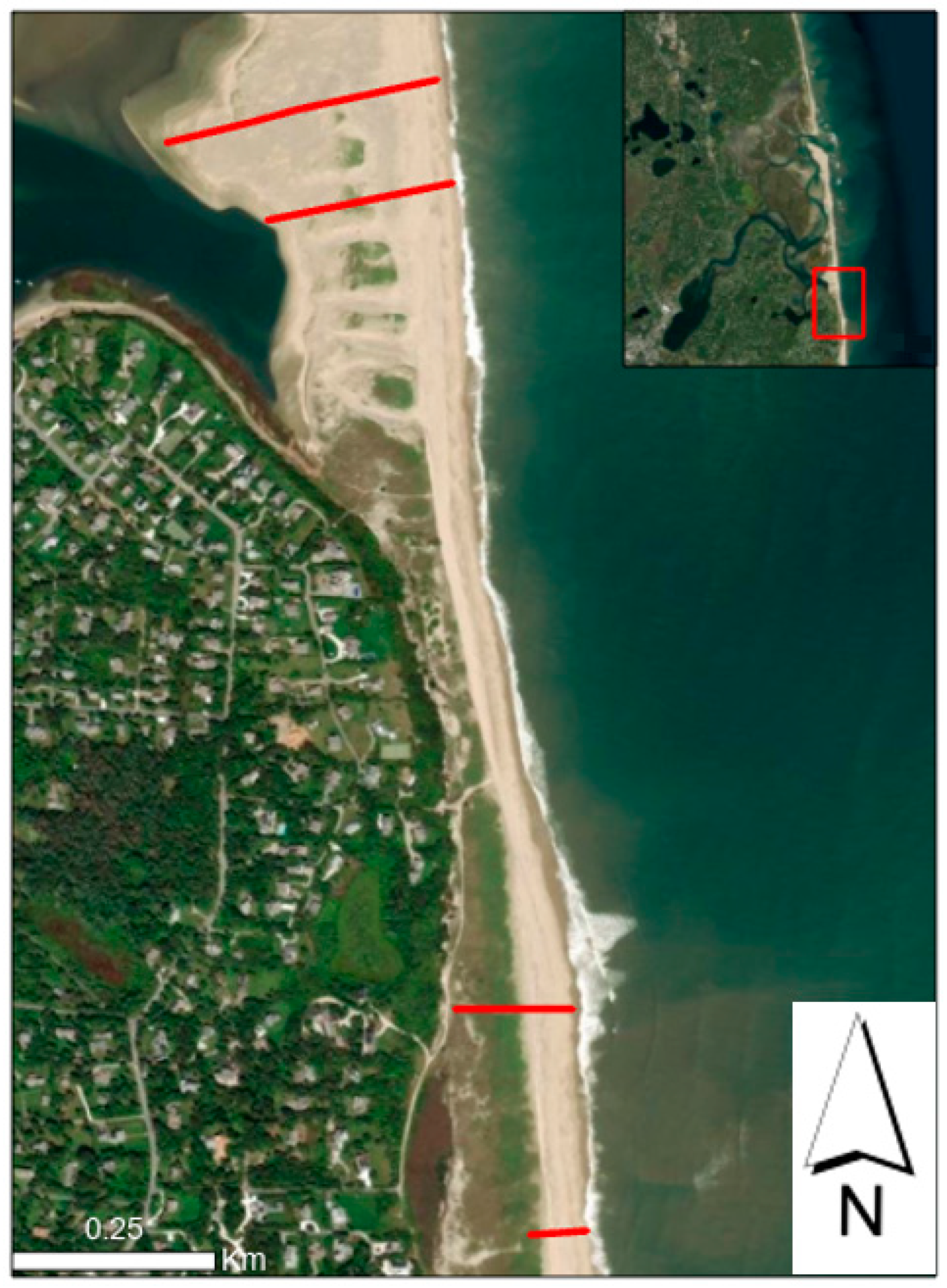
1.2. Study Area
2. Materials and Methods
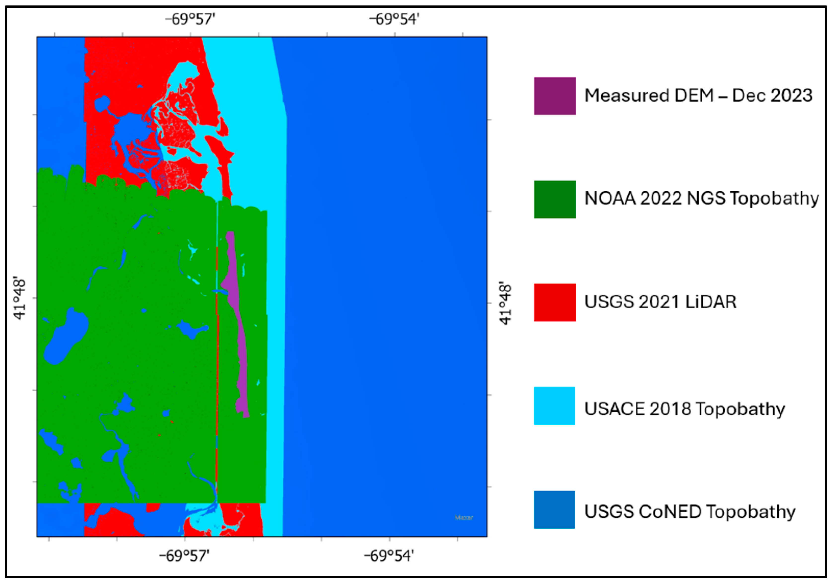
2.1. Historical Data
2.2. Data Collection and Processing
2.2.1. Mapping
2.2.2. Producing DEMs from Drone Imagery
2.2.3. Ground Surveys
2.3. XBeach Modeling
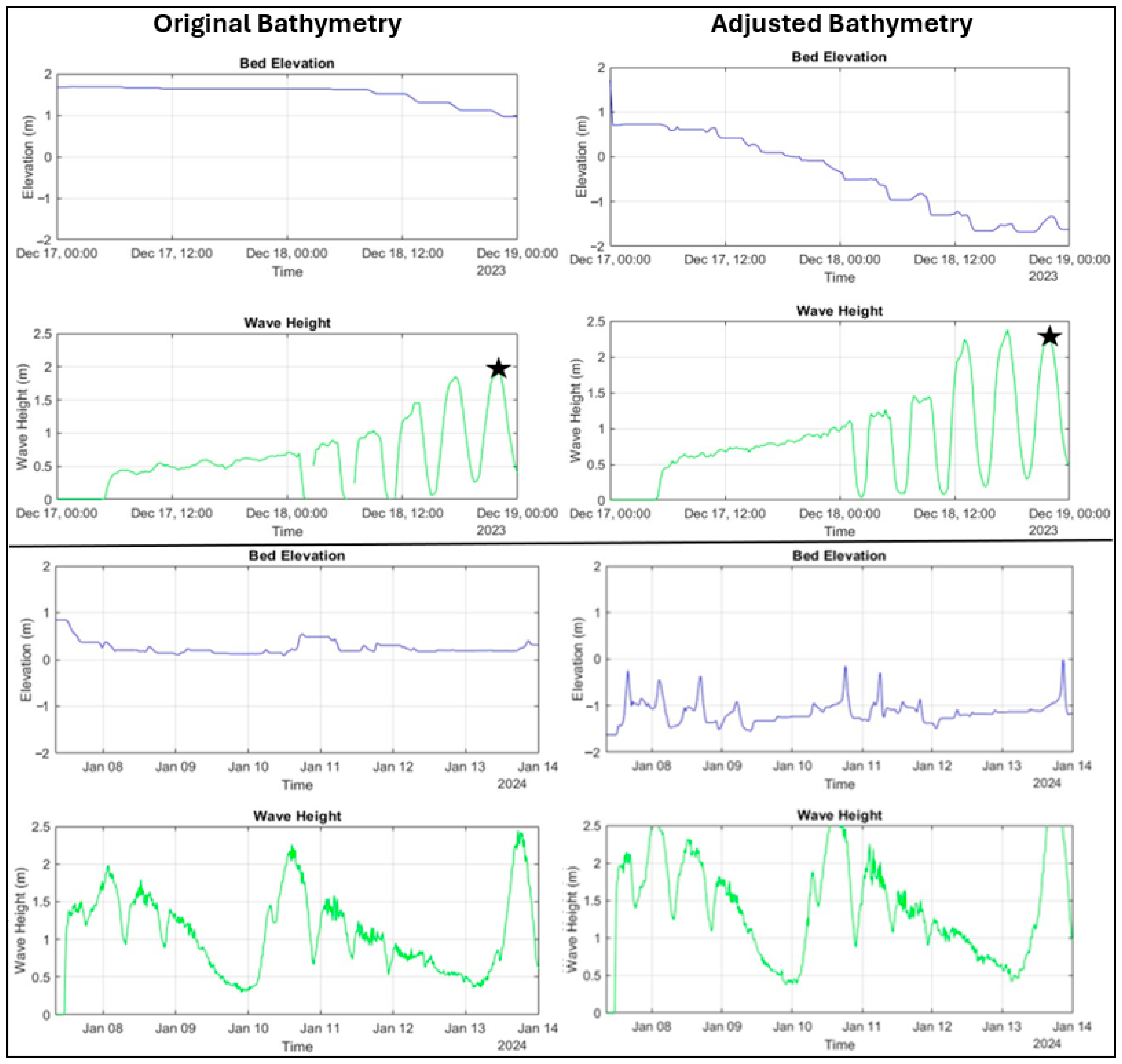
2.3.1. Model Setup and Calibration
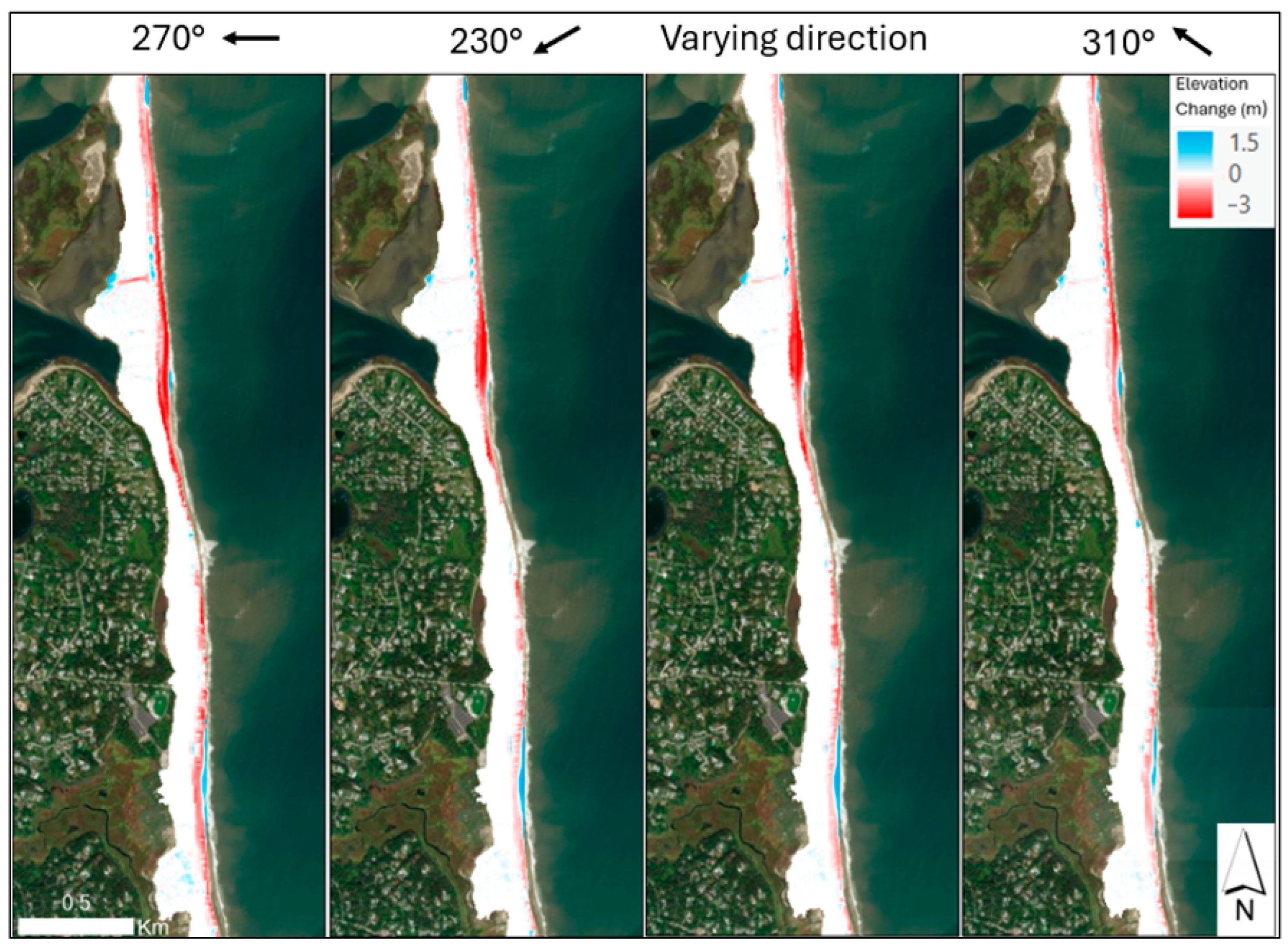
2.3.2. Modeling the Influence of Wave Direction and Bathymetry on Subaerial Erosion
2.3.3. Modeling the Effects of Sea-Level Rise on Storm Impacts
2.3.4. Model Limitations
3. Results
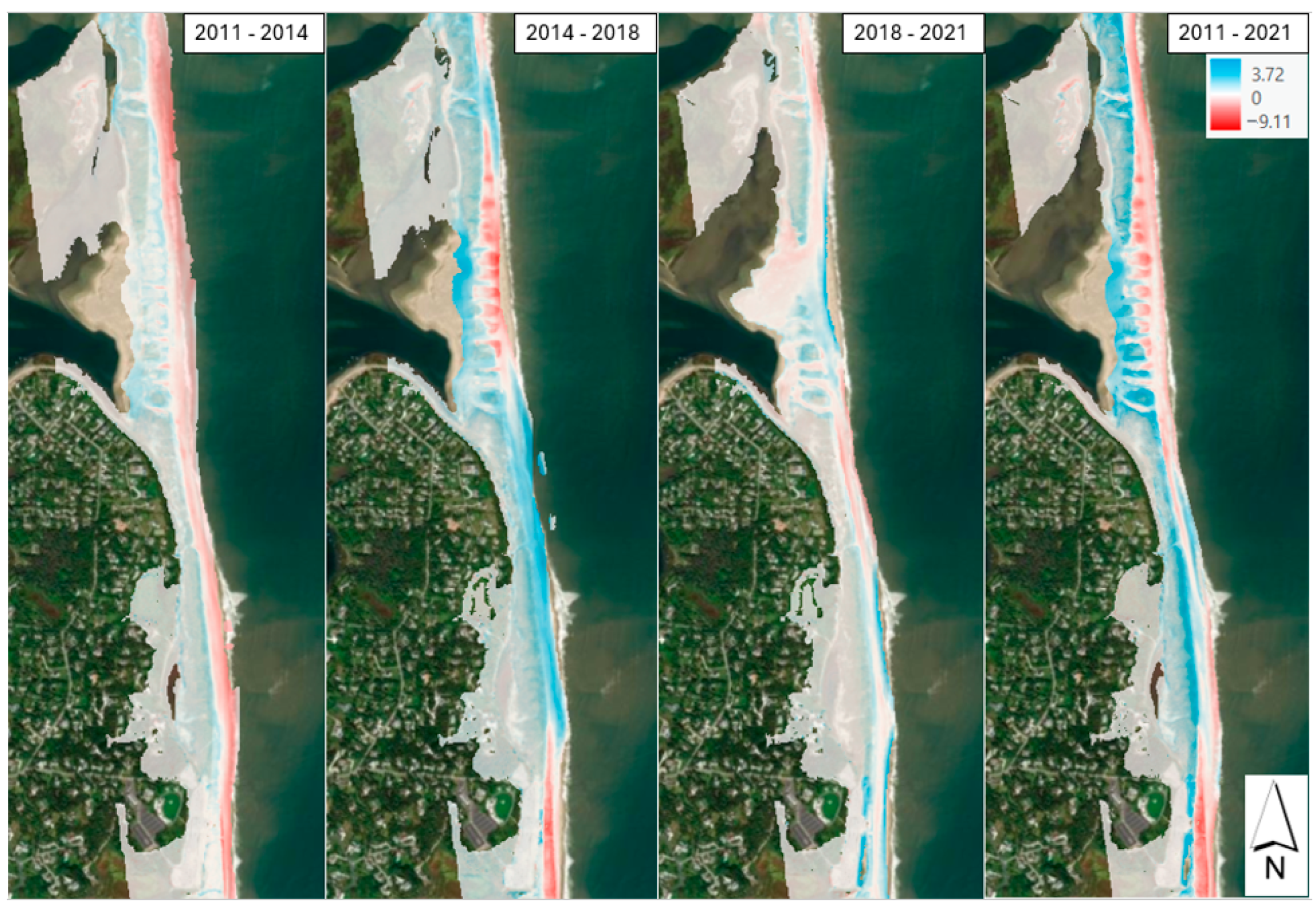
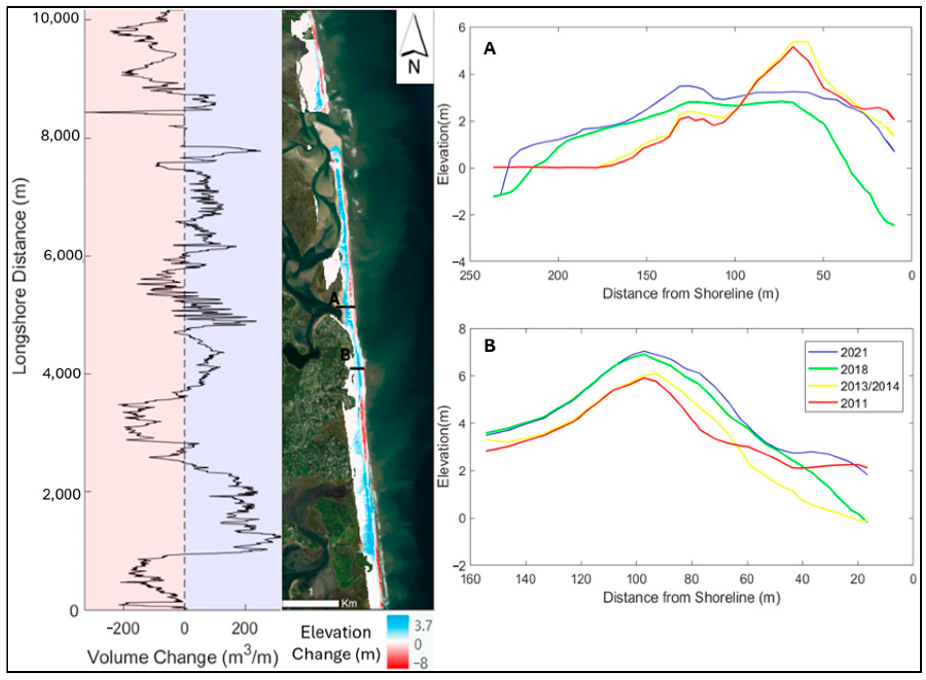
3.1. Long-Term Morphological Changes
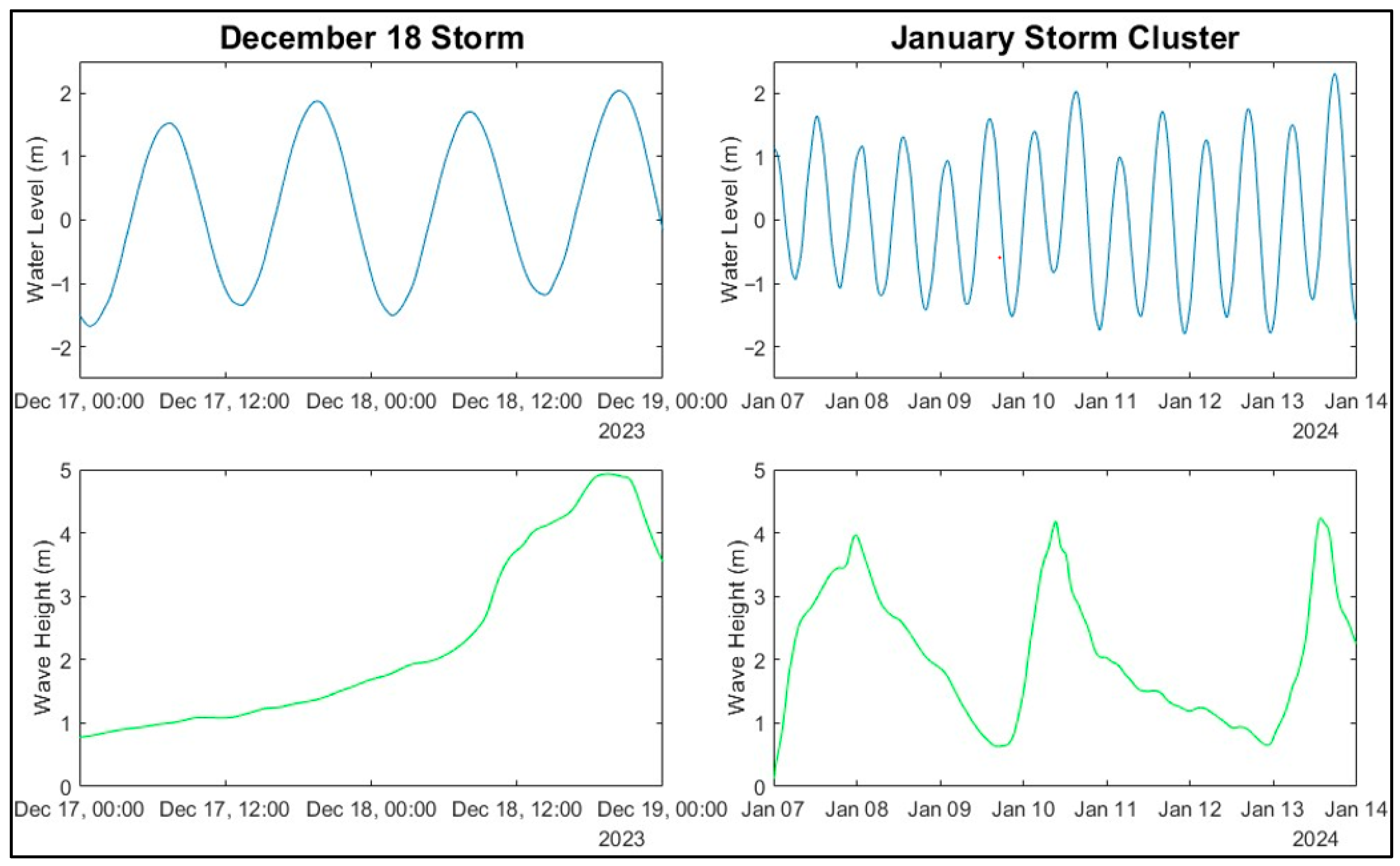
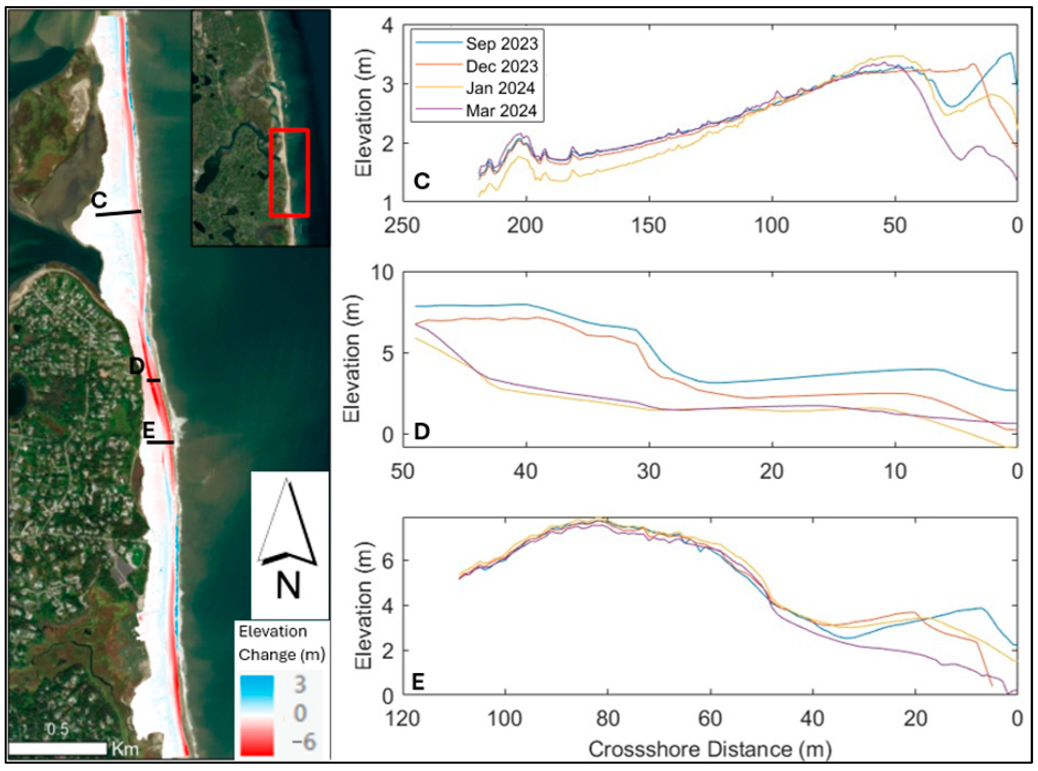
3.2. Winter 2023/24 Beach Evolution
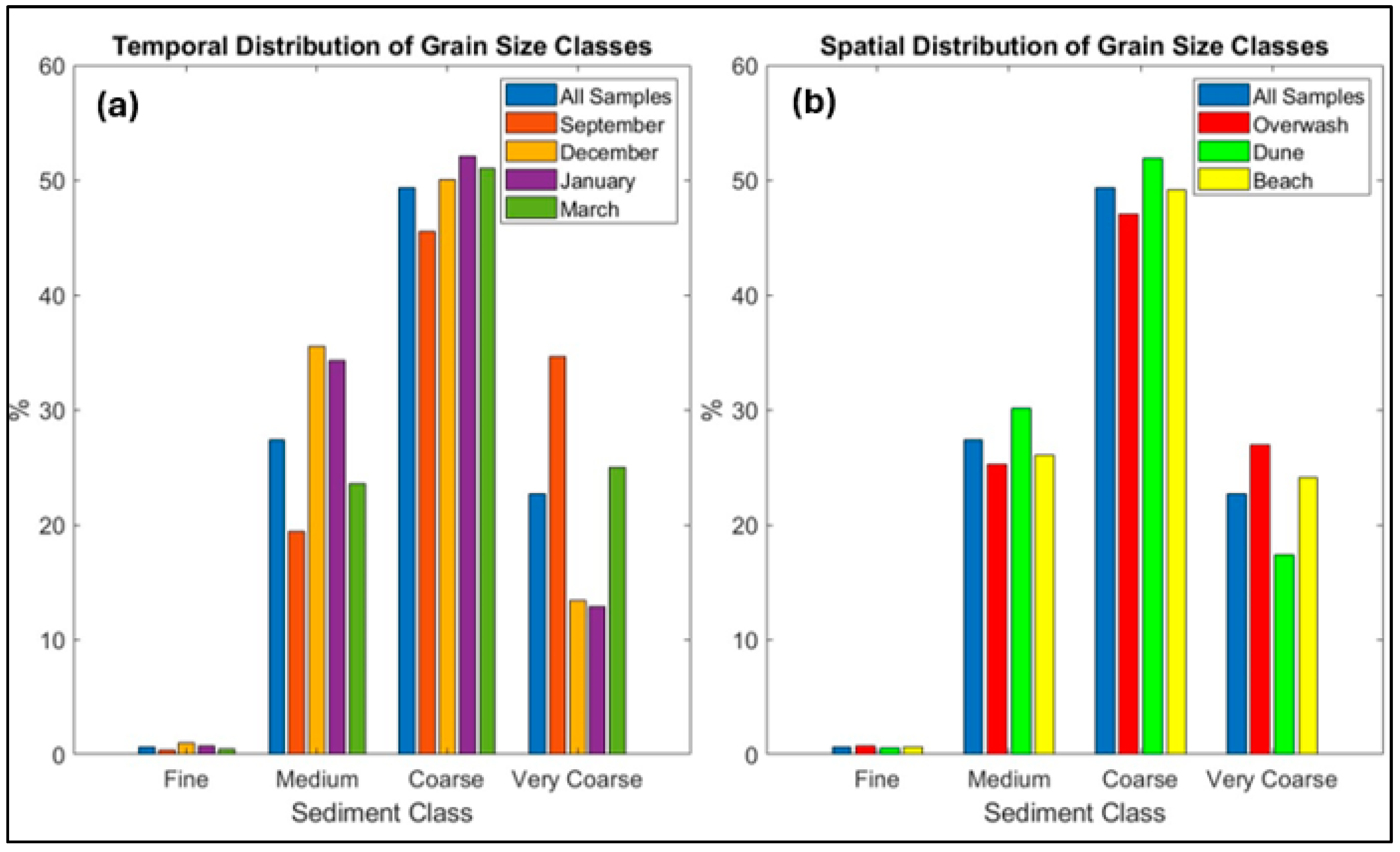
3.3. Sediment Composition
3.4. Modeling Results
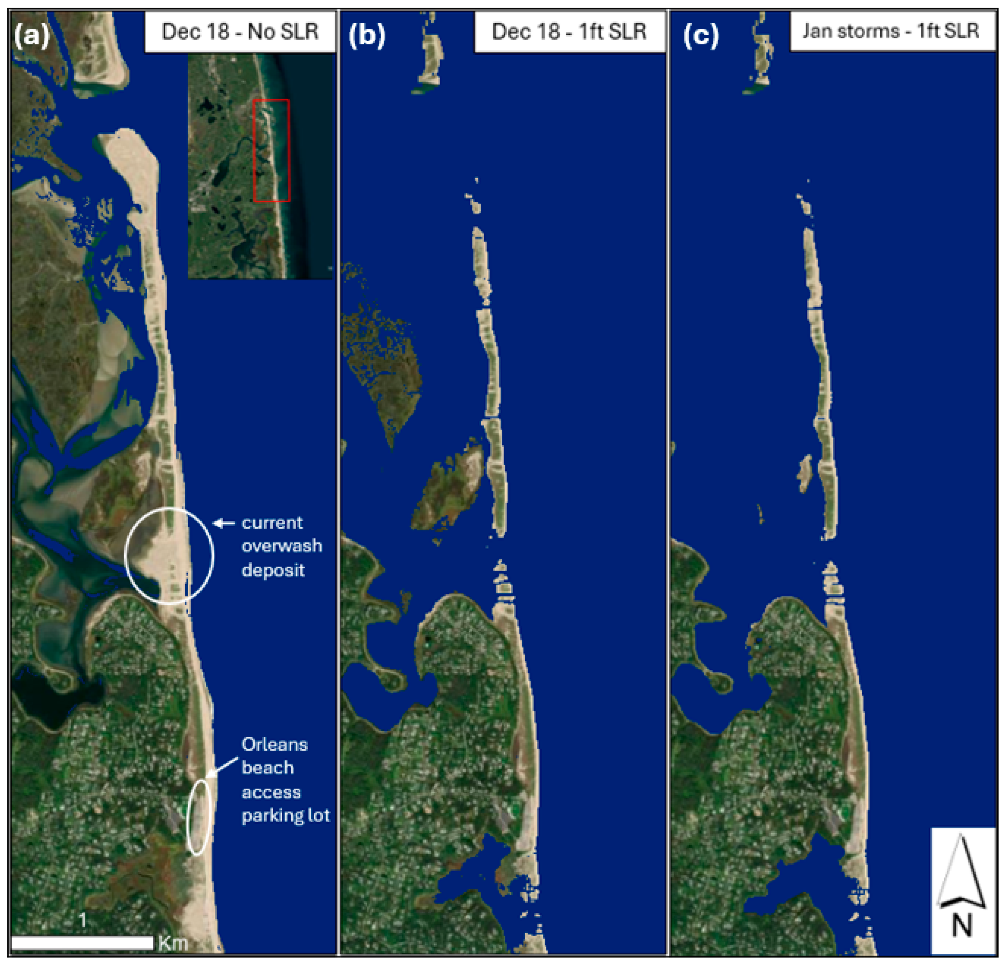
Sea-Level Rise Simulations
4. Discussion
4.1. Storm-Driven Beach System Evolution
4.1.1. Historical Storm Impacts (2011–2021)
4.1.2. Impacts of Successive Winter Storms
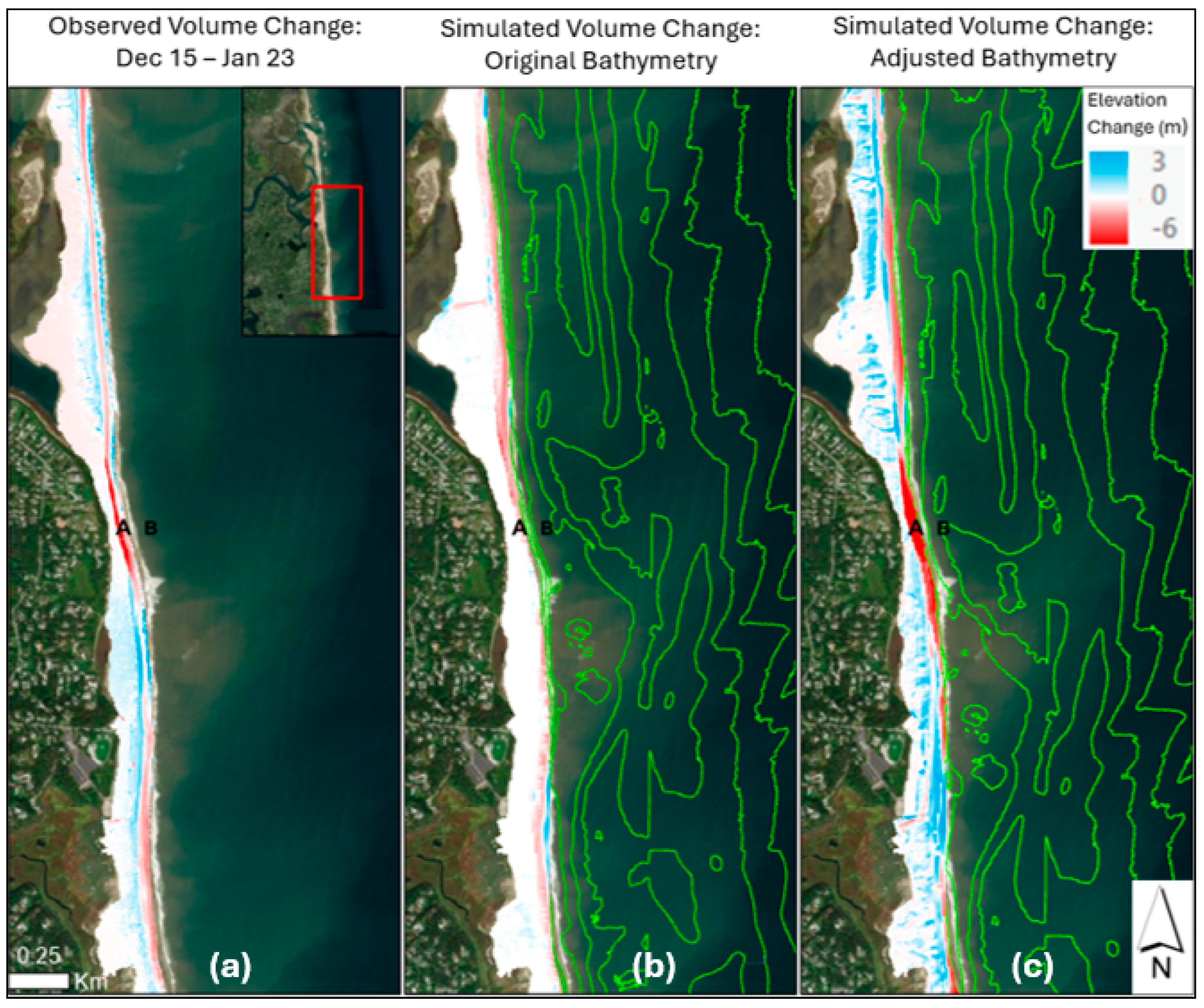
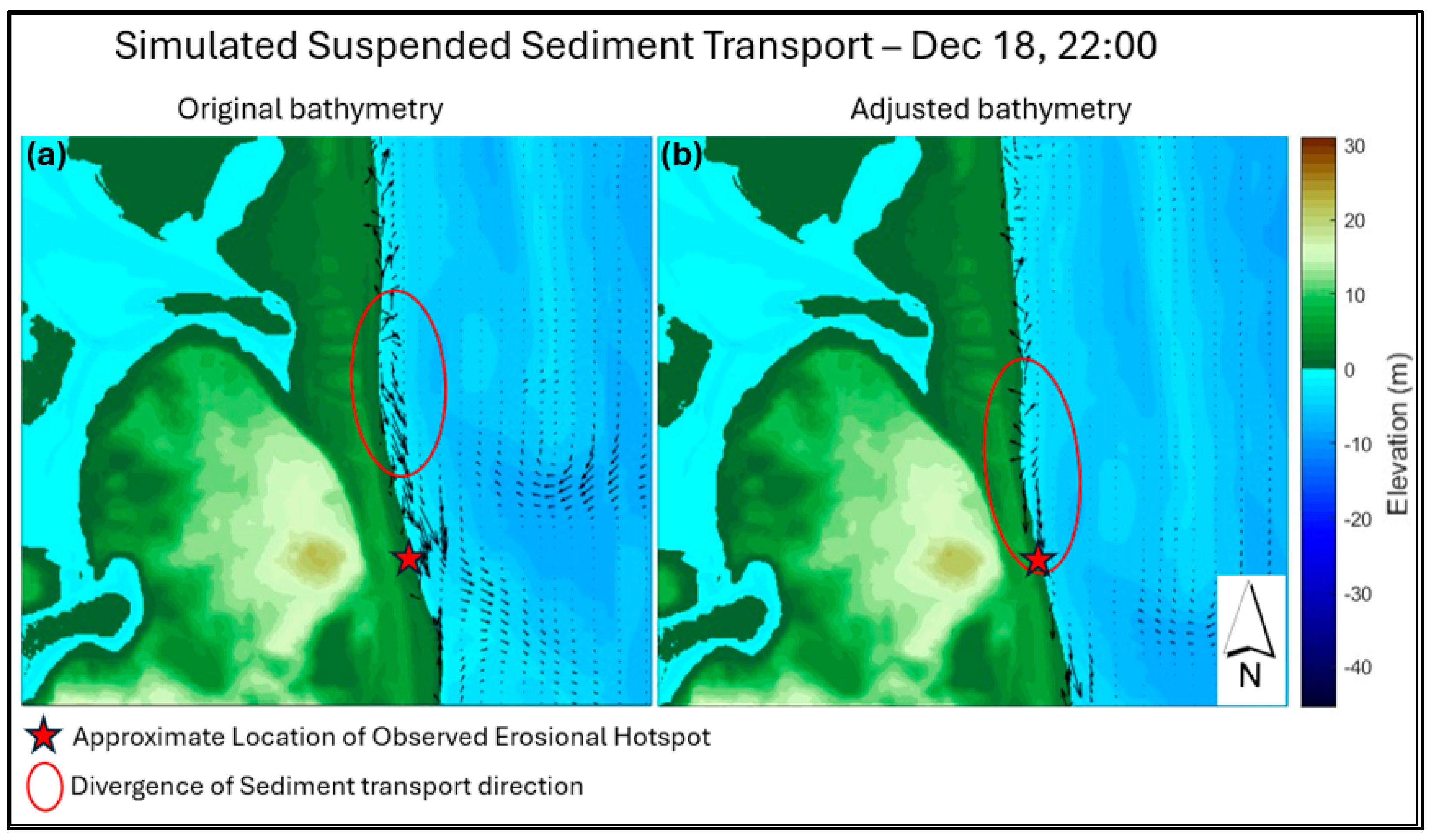
4.2. Controls on the Observed Erosion
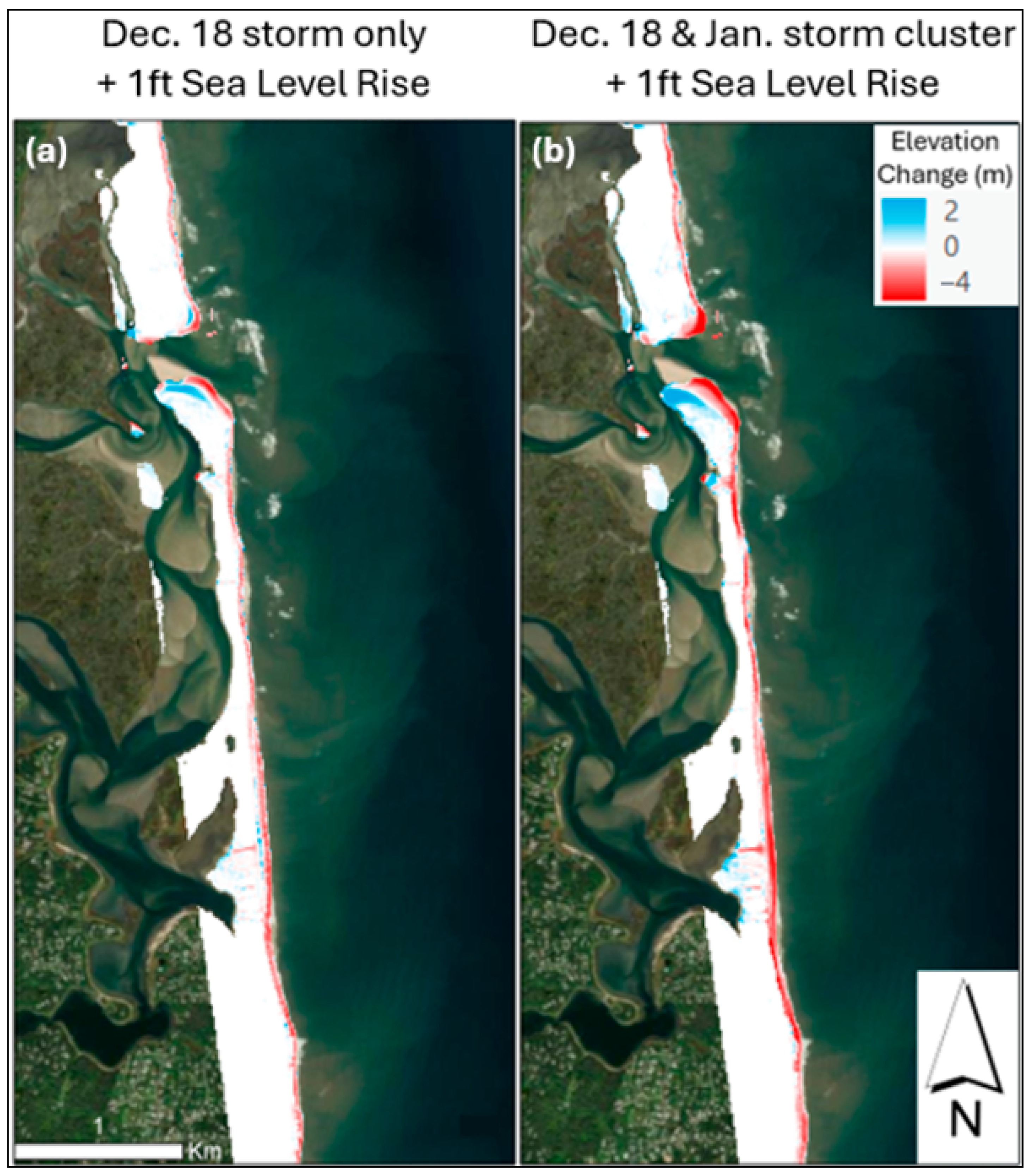
4.3. Storm-Impacts with Sea-Level Rise (SLR)
5. Conclusions
- Evolution of the geomorphology of Nauset Beach was spatially and temporally variable, with the largest changes occurring during storms. Over the past decade, the seaward portions of the beach have generally eroded, while landward portions of the system have accreted, suggesting landward migration, as has been observed in other barrier systems.
- During the winter of 2023–2024, the system experienced significant beach and dune erosion. During this period, the greatest changes to the beach were observed between 15 December and 23 January, and were primarily caused by the cumulative impacts of storms on 18 December, and 7, 10, and 13 January. These storms caused variable amounts of erosion and accretion alongshore, and an erosional hotspot, which have been observed in numerous barrier systems driven by a variety of anthropogenic and natural factors, was identified just south of the spit near Nauset Heights, Orleans.
- Results from XBeach modeling indicated that the location of the erosional hotspot between December and January was largely influenced by the nearshore sandbar configuration. The model scenarios demonstrated how a break in the sandbar increased wave energy and sediment flux near the section of beach that was most severely eroded, and wave direction could not account for the southerly displacement of the erosion hotspot. Dune erosion was augmented in an area with a narrower beach face, which was also likely driven by the influence of the nearshore bathymetry on wave energy and sediment transport.
- Modeling results indicated that with 0.3 m (1 ft) of SLR, the study area would experience increased erosion during storms as well as more frequent overwash and inundation events. As dune overtopping and breaching become more common in response to higher sea levels, consecutive storms, even of moderate intensity, pose a significant risk of breaching and inlet formation. This research can be used to inform local management as well as dynamics of barrier systems globally.
Author Contributions
Funding
Data Availability Statement
Acknowledgments
Conflicts of Interest
Appendix A
XBeach Model Calibration

| Simulation # | Facua (γua) | Beta (β) | ΔV (m3/m) | ESS |
|---|---|---|---|---|
| 1 | 0.24 | 0.06 | −29.88 | 0.702 |
| 2 | 0.24 | 0.07 | −24.06 | 0.708 |
| 3 | 0.24 | 0.08 | −14.75 | 0.714 |
| 4 | 0.22 | 0.07 | −29.52 | 0.704 |
| 5 | 0.22 | 0.1 | −25.08 | 0.711 |
Appendix B
Appendix B.1. Grain Size Distributions
| Collection Date | Mean D10 (µm) | Mean D50 (µm) | Mean D90 (µm) |
|---|---|---|---|
| 6 September 2023 | 553.2 | 954.8 | 1719.3 |
| 15 December 2023 * | 436.2 | 703.7 | 1209.3 |
| 23 January 2024 | 443.3 | 713.8 | 1188.4 |
| 14 March 2024 | 486.0 | 833.3 | 1505.8 |
| Transect # | Mean D10 (µm) | Mean D50 (µm) | Mean D90 (µm) |
|---|---|---|---|
| 1 (Overwash fan) | 452.0 | 784.7 | 1479.4 |
| 2 (Overwash fan) | 424.4 | 684.5 | 1185.4 |
| 3 (Hotspot) | 443.2 | 693.1 | 1140.7 |
| 4 (South of Hotspot) | 424.4 | 637.2 | 970.1 |
Appendix B.2. Additional Figures
References
- McGranahan, G.; Balk, D.; Anderson, B. The Rising Tide: Assessing the Risks of Climate Change and Human Settlements in Low Elevation Coastal Zones. Environ. Urban. 2007, 19, 17–37. [Google Scholar] [CrossRef]
- Crossett, K.; Ache, B.; Pacheco, P.; Haber, K. National Coastal Population Report Population Trends from 1970 to 2020. NOAA’s State of the Coast. 2013. Available online: https://aambpublicoceanservice.blob.core.windows.net/oceanserviceprod/facts/coastal-population-report.pdf (accessed on 14 July 2024).
- Church, J.A.; White, N.J. Sea-Level Rise from the Late 19th to the Early 21st Century. Surv. Geophys. 2011, 32, 585–602. [Google Scholar] [CrossRef]
- Kopp, R.E.; Kemp, A.C.; Bittermann, K.; Horton, B.P.; Donnelly, J.P.; Gehrels, W.R.; Hay, C.C.; Mitrovica, J.X.; Morrow, E.D.; Rahmstorf, S. Temperature-Driven Global Sea-Level Variability in the Common Era. Proc. Natl. Acad. Sci. USA 2016, 113, 1434–1441. [Google Scholar] [CrossRef] [PubMed]
- Sweet, W.V.; Hamlington, B.D.; Kopp, R.E.; Weaver, C.P.; Barnard, P.L.; Bekaert, D.; Brooks, W.; Craghan, M.; Dusek, G.; Frederikse, T.; et al. Global and Regional Sea Level Rise Scenarios for the United States: Updated Mean Projections and Extreme Water Level Probabilities Along U.S. Coastlines; NOAA Technical Report NOS 01; National Oceanic and Atmospheric Administration, National Ocean Service: Silver Spring, MD, USA, 2022. [Google Scholar]
- FitzGerald, D.M.; Fenster, M.S.; Argow, B.A.; Buynevich, I.V. Coastal Impacts Due to Sea-Level Rise. Annu. Rev. Earth Planet. Sci. 2008, 36, 601–647. [Google Scholar] [CrossRef]
- Goslin, J.; Clemmensen, L.B. Proxy Records of Holocene Storm Events in Coastal Barrier Systems: Storm-Wave Induced Markers. Quat. Sci. Rev. 2017, 174, 80–119. [Google Scholar] [CrossRef]
- Otvos, E.G. Coastal Barriers-Fresh Look at Origins, Nomenclature and Classification Issues. Geomorphology 2020, 355, 107000. [Google Scholar] [CrossRef]
- Luijendijk, A.; Hagenaars, G.; Ranasinghe, R.; Baart, F.; Donchyts, G.; Aarninkhof, S. The State of the World’s Beaches. Sci. Rep. 2018, 8, 6641. [Google Scholar] [CrossRef] [PubMed]
- Pilkey, O.H.; Cooper, J.A.G.; Lewis, D.A. Global Distribution and Geomorphology of Fetch-Limited Barrier Islands. J. Coast. Res. 2009, 254, 819–837. [Google Scholar] [CrossRef]
- Elliff, C.I.; Kikuchi, R.K.P. The Ecosystem Service Approach and Its Application as a Tool for Integrated Coastal Management. Nat. Conserv. 2015, 13, 105–111. [Google Scholar] [CrossRef]
- Millennium Ecosystem Assessment (Program) (Ed.) Ecosystems and Human Well-Being: Wetlands and Water Synthesis: A Report of the Millennium Ecosystem Assessment; World Resources Institute: Washington, DC, USA, 2005; ISBN 978-1-56973-597-8. [Google Scholar]
- Barbier, E.B.; Hacker, S.D.; Kennedy, C.; Koch, E.W.; Stier, A.C.; Silliman, B.R. The Value of Estuarine and Coastal Ecosystem Services. Ecol. Monogr. 2011, 81, 169–193. [Google Scholar] [CrossRef]
- Kildow, J.T.; Colgan, C.S.; Johnson, P.; Scorse, J.D.; Farnum, M.G. State of the U.S. Ocean and Coastal Economies—2016 Update; Middlebury Institute of International Studies at Monterey: Monterey, CA, USA, 2016; p. 31. [Google Scholar]
- Pilkey, O.H.; Cooper, J.A.G. Are Natural Beaches Facing Extinction? J. Coast. Res. 2014, 70, 431–436. [Google Scholar] [CrossRef]
- Rogers, L.J.; Moore, L.J.; Goldstein, E.B.; Hein, C.J.; Lorenzo-Trueba, J.; Ashton, A.D. Anthropogenic Controls on Overwash Deposition: Evidence and Consequences. J. Geophys. Res. Earth Surf. 2015, 120, 2609–2624. [Google Scholar] [CrossRef]
- Leatherman, S.P. Barrier Dune Systems: A Reassessment. Sediment. Geol. 1979, 24, 1–16. [Google Scholar] [CrossRef]
- Sallenger, A.H. Storm Impact Scale for Barrier Islands. J. Coast. Res. 2000, 16, 7. [Google Scholar]
- Masselink, G.; Van Heteren, S. Response of Wave-Dominated and Mixed-Energy Barriers to Storms. Mar. Geol. 2014, 352, 321–347. [Google Scholar] [CrossRef]
- Lorenzo-Trueba, J.; Ashton, A.D. Rollover, Drowning, and Discontinuous Retreat: Distinct Modes of Barrier Response to Sea-level Rise Arising from a Simple Morphodynamic Model. JGR Earth Surf. 2014, 119, 779–801. [Google Scholar] [CrossRef]
- Passeri, D.L.; Dalyander, P.S.; Long, J.W.; Mickey, R.C.; Jenkins, R.L.; Thompson, D.M.; Plant, N.G.; Godsey, E.S.; Gonzalez, V.M. The Roles of Storminess and Sea Level Rise in Decadal Barrier Island Evolution. Geophys. Res. Lett. 2020, 47, e2020GL089370. [Google Scholar] [CrossRef]
- Conery, I.; Walsh, J.P.; Reide Corbett, D. Hurricane Overwash and Decadal-Scale Evolution of a Narrowing Barrier Island, Ocracoke Island, NC. Estuaries Coasts 2018, 41, 1626–1642. [Google Scholar] [CrossRef]
- Donnelly, C.; Kraus, N.C.; Larson, M. Coastal Overwash: Part 1, Overview of Processes. 2004. Available online: https://apps.dtic.mil/sti/tr/pdf/ADA602107.pdf (accessed on 14 July 2024).
- Kraus, N.C.; Militello, A.; Todoroff, G. Barrier Breaching Processes and Barrier Spit Breach, Stone Lagoon, California. 2002. Available online: https://apps.dtic.mil/sti/tr/pdf/ADA483417.pdf (accessed on 14 July 2024).
- McCall, R.T.; Van Thiel De Vries, J.S.M.; Plant, N.G.; Van Dongeren, A.R.; Roelvink, J.A.; Thompson, D.M.; Reniers, A.J.H.M. Two-Dimensional Time Dependent Hurricane Overwash and Erosion Modeling at Santa Rosa Island. Coast. Eng. 2010, 57, 668–683. [Google Scholar] [CrossRef]
- McCall, R.; Masselink, G.; Poate, T.; Bradbury, A.; Russell, P.; Davidson, M. Predicting Overwash on Gravel Barriers. J. Coast. Res. 2013, 165, 1473–1478. [Google Scholar] [CrossRef]
- Plomaritis, T.A.; Ferreira, Ó.; Costas, S. Regional Assessment of Storm Related Overwash and Breaching Hazards on Coastal Barriers. Coast. Eng. 2018, 134, 124–133. [Google Scholar] [CrossRef]
- Roelvink, D.; Reniers, A.; Van Dongeren, A.; Van Thiel De Vries, J.; McCall, R.; Lescinski, J. Modelling Storm Impacts on Beaches, Dunes and Barrier Islands. Coast. Eng. 2009, 56, 1133–1152. [Google Scholar] [CrossRef]
- Stockdon, H.F.; Sallenger, A.H.; Holman, R.A.; Howd, P.A. A Simple Model for the Spatially-Variable Coastal Response to Hurricanes. Mar. Geol. 2007, 238, 1–20. [Google Scholar] [CrossRef]
- Schambach, L.; Grilli, A.R.; Grilli, S.T.; Hashemi, M.R.; King, J.W. Assessing the Impact of Extreme Storms on Barrier Beaches along the Atlantic Coastline: Application to the Southern Rhode Island Coast. Coast. Eng. 2018, 133, 26–42. [Google Scholar] [CrossRef]
- Schuh, E.; Grilli, A.R.; Groetsch, F.; Grilli, S.T.; Crowley, D.; Ginis, I.; Stempel, P. Assessing the morphodynamic response of a New England beach-barrier system to an artificial reef. Coast. Eng. 2023, 184, 104355. [Google Scholar] [CrossRef]
- Grilli, A.R.; Westcott, G.; Grilli, S.; Spaulding, M.L.; Shi, F. and J.T. Kirby. Assessing coastal risk from extreme storms with a phase resolving wave model: Case Study of Narragansett, RI, USA. Coast. Eng. 2020, 160, 103735. [Google Scholar] [CrossRef]
- Grilli, A.R.; Spaulding, M.L.; Oakley, B.A.; Damon, C. Mapping the coastal risk for the next century, including sea level rise and changes in the coastline: Application to Charlestown RI, USA. Nat. Hazards 2017, 88, 389–414. [Google Scholar] [CrossRef]
- Kraus, N.C.; Galgano, F.A. Beach Erosional Hot Spots: Types, Causes, and Solutions. 2001. Available online: https://apps.dtic.mil/sti/tr/pdf/ADA588792.pdf (accessed on 14 July 2024).
- McNinch, J.E. Geologic Control in the Nearshore: Shore-Oblique Sandbars and Shoreline Erosional Hotspots, Mid-Atlantic Bight, USA. Mar. Geol. 2004, 211, 121–141. [Google Scholar] [CrossRef]
- Mulligan, R.P.; Gomes, E.R.; Miselis, J.L.; McNinch, J.E. Non-Hydrostatic Numerical Modelling of Nearshore Wave Transformation over Shore-Oblique Sandbars. Estuar. Coast. Shelf Sci. 2019, 219, 151–160. [Google Scholar] [CrossRef]
- Stive, M.J.F.; Guillen, J.; Capobianco, M. Bar Migration and Duneface Oscillation on Decadal Scales. In Proceedings of the Coastal Engineering 1996; American Society of Civil Engineers: Orlando, FL, USA, 1997; pp. 2884–2896. [Google Scholar]
- List, J.H.; Farris, A.S.; Sullivan, C. Reversing Storm Hotspots on Sandy Beaches: Spatial and Temporal Characteristics. Mar. Geol. 2006, 226, 261–279. [Google Scholar] [CrossRef]
- Joyce, K.E.; Belliss, S.E.; Samsonov, S.V.; McNeill, S.J.; Glassey, P.J. A Review of the Status of Satellite Remote Sensing and Image Processing Techniques for Mapping Natural Hazards and Disasters. Prog. Phys. Geogr. Earth Environ. 2009, 33, 183–207. [Google Scholar] [CrossRef]
- Moore, L.J. Shoreline Mapping Techniques. J. Coast. Res. 2024, 16, 111–124. [Google Scholar]
- Giordan, D.; Manconi, A.; Remondino, F.; Nex, F. Use of Unmanned Aerial Vehicles in Monitoring Application and Management of Natural Hazards. Geomat. Nat. Hazards Risk 2017, 8, 1–4. [Google Scholar] [CrossRef]
- Caroti, G.; Piemonte, A.; Pieracci, Y. Low-Altitude UAV-Borne Remote Sensing in Dunes Environment: Shoreline Monitoring and Coastal Resilience. In Computational Science and Its Applications–ICCSA 2018; Gervasi, O., Murgante, B., Misra, S., Stankova, E., Torre, C.M., Rocha, A.M.A.C., Taniar, D., Apduhan, B.O., Tarantino, E., Ryu, Y., Eds.; Lecture Notes in Computer Science; Springer International Publishing: Cham, Switzerland, 2018; Volume 10964, pp. 281–293. ISBN 978-3-319-95173-7. [Google Scholar]
- Westoby, M.J.; Brasington, J.; Glasser, N.F.; Hambrey, M.J.; Reynolds, J.M. ‘Structure-from-Motion’ Photogrammetry: A Low-Cost, Effective Tool for Geoscience Applications. Geomorphology 2012, 179, 300–314. [Google Scholar] [CrossRef]
- Mancini, F.; Dubbini, M.; Gattelli, M.; Stecchi, F.; Fabbri, S.; Gabbianelli, G. Using Unmanned Aerial Vehicles (UAV) for High-Resolution Reconstruction of Topography: The Structure from Motion Approach on Coastal Environments. Remote Sens. 2013, 5, 6880–6898. [Google Scholar] [CrossRef]
- Beckman, J.N.; Long, J.W.; Hawkes, A.D.; Leonard, L.A.; Ghoneim, E. Investigating Controls on Barrier Island Overwash and Evolution during Extreme Storms. Water 2021, 13, 2829. [Google Scholar] [CrossRef]
- Nederhoff, K.; Lodder, Q.; Boers, M.; Bieman, J.; Miller, J. Modelling the Effects of Hard Structures on Dune Erosion and Overwash-a Case Study of the Impact of Hurricane Sandy on the New Jersey Coast. 2015. Available online: https://www.researchgate.net/publication/311934611_Modeling_the_effects_of_hard_structures_on_dune_erosion_and_overwash (accessed on 14 July 2024).
- Giese, G.S.; Borrelli, M.; Mague, S.T. Tidal Inlet Evolution and Impacts of Anthropogenic Alteration: An Example from Nauset Beach and Pleasant Bay, Cape Cod, Massachusetts. Northeast. Nat. 2020, 27, 1. [Google Scholar] [CrossRef]
- Borrelli, M.; Boothroyd, J.C. Calculating Rates of Shoreline Change in a Coastal Embayment with Fringing Salt Marsh Using the “Marshline”, a Proxy-Based Shoreline Indicator. Northeast. Nat. 2020, 27, 132. [Google Scholar] [CrossRef]
- Redfield, A.C. Ontogeny of a Salt Marsh Estuary. Science 1965, 147, 50–55. [Google Scholar] [CrossRef] [PubMed]
- Redfield, A.C. Development of a New England Salt Marsh. Ecol. Monogr. 1972, 42, 201–237. [Google Scholar] [CrossRef]
- Data Cape Cod. Available online: https://datacapecod.org/pf/barnstable-county-year-round-population/ (accessed on 14 July 2024).
- Hotchkiss, E.; Kandt, A.; Holm, A.; McKean, L.; Norton, S. Resilience Assessment: Cape Cod National Seashore; NREL/TP-7A40-79171; National Renewable Energy Laboratory: Golden, CO, USA, 2021. [Google Scholar]
- Borrelli, M.; Giese, G.; Mague, S.T.; Smith, T.; Mittermayr, A.; Legare, B.J.; Solazzo, D. Potential Impacts to the Nau-set Barrier from the Proposed Dredging and Disposal in Nauset Harbor; Coastal Processes and Ecosystems Laboratory, Center for Coastal Studies: Provincetown, MA, USA, 2019. [Google Scholar] [CrossRef]
- Giese, G.S.; Adams, M.B.; Rogers, S.S.; Lawrence Dingman, S.; Borrelli, M.; Smith, T.L. Coastal Sediment Transport on Outer Cape Cod, Massachusetts: Observation And Theory. In The Proceedings of the Coastal Sediments 2011; World Scientific Publishing Company: Miami, Florida, USA, 2011; pp. 2353–2365. [Google Scholar]
- Bartlett, M.K.; Henderson, R.E.; Farris, A.; Himmelstoss, E. Massachusetts Shoreline Change Project, 2021 Update: A GIS Compilation of Shoreline Change Rates Calculated Using Digital Shoreline Analysis System Version 5.1, With Supplementary Intersects and Baselines for Massachusetts; Woods Hole Coastal and Marine Science Center: Woods Hole, MA, USA, 2021. [Google Scholar]
- Aubrey, D.G.; Speer, P.E. Updrift Migration of Tidal Inlets. J. Geol. 1984, 92, 531–545. [Google Scholar] [CrossRef]
- Woods Hole Group. Nauset Estuary Dredging Feasibility Assessment; Prepared for the town of Orleans by Woods Hole Group. 2016. Available online: https://town.orleans.ma.us/DocumentCenter/View/6533/Nauset-Estuary-Dredging-Feasibility-Assessment---WHG-Feb-2016 (accessed on 14 July 2024).
- NOAA: Data Access Viewer. Available online: https://coast.noaa.gov/dataviewer/#/lidar/search/ (accessed on 5 September 2024).
- Pix4D Documentation|PIX4Dmapper. Available online: https://support.pix4d.com/hc/pix4dmapper#manual (accessed on 5 September 2024).
- National Geodetic Survey, 2024: 2022 NOAA NGS Topobathy Lidar: Chatham Bay to Monomoy Point, MA. Available online: https://coast.noaa.gov/dataviewer/#/lidar/search/-7804526.336029637,5124338.376238216,-7778598.881106198,5153200.977591176 (accessed on 14 July 2024).
- OCM Partners, 2024: 2021 USGS Lidar: Central Eastern Massachusetts. Available online: https://coast.noaa.gov/dataviewer/#/lidar/search/-7804526.336029637,5124338.376238216,-7778598.881106198,5153200.977591176 (accessed on 14 July 2024).
- OCM Partners, 2024: 2018 USACE NCMP Topobathy LiDAR DEM: East Coast (CT, MA, ME, NC, NH, RI, SC). Available online: https://coast.noaa.gov/dataviewer/#/lidar/search/-7804526.336029637,5124338.376238216,-7778598.881106198,5153200.977591176 (accessed on 14 July 2024).
- OCM Partners, 2024: 1887–2016 USGS CoNED Topobathy DEM (Compiled 2016): New England. Available online: https://coast.noaa.gov/dataviewer/#/lidar/search/-7804526.336029637,5124338.376238216,-7778598.881106198,5153200.977591176 (accessed on 14 July 2024).
- Office for Coastal Management, 2024: 2020–2023 CCAP Version 2 Impervious Cover. Available online: https://coast.noaa.gov/dataviewer/#/landcover/search/-7791837.789334295,5123421.131898793,-7780708.559882113,5138830.834934946 (accessed on 14 July 2024).
- Office for Coastal Management, 2024: C-CAP Land Cover, Massachusetts. 2016. Available online: https://coast.noaa.gov/dataviewer/#/landcover/search/-7791837.789334295,5123421.131898793,-7780708.559882113,5138830.834934946 (accessed on 14 July 2024).
- Dietrich, J.C.; Westerink, J.J.; Kennedy, A.B.; Smith, J.M.; Jensen, R.E.; Zijlema, M.; Holthuijsen, L.H.; Dawson, C.; Luettich, R.A.; Powell, M.D.; et al. Hurricane Gustav (2008) Waves and Storm Surge: Hindcast, Synoptic Analysis, and Validation in Southern Louisiana. Mon. Weather Rev. 2011, 139, 2488–2522. [Google Scholar] [CrossRef]
- Dee, D.P.; Uppala, S.M.; Simmons, A.J.; Berrisford, P.; Poli, P.; Kobayashi, S.; Andrae, U.; Balmaseda, M.A.; Balsamo, G.; Bauer, P.; et al. The ERA-Interim Reanalysis: Configuration and Performance of the Data Assimilation System. Q. J. R. Meteorol. Soc. 2011, 137, 553–597. [Google Scholar] [CrossRef]
- National Weather Service Coastal Storm: December 17–18, 2023. Available online: https://www.weather.gov/ilm/Dec2023CoastalStorm (accessed on 16 July 2024).
- National Data Buoy Center Buoy Data from Station 44018. Available online: https://www.ndbc.noaa.gov/station_history.php?station=44018 (accessed on 16 July 2024).
- January 2024 National Climate Report | National Centers for Environmental Information (NCEI). Available online: https://www.ncei.noaa.gov/access/monitoring/monthly-report/national/202401 (accessed on 16 July 2024).
- Zhang, K.; Douglas, B.C.; Leatherman, S.P. Twentieth-Century Storm Activity along the U.S. East Coast. J. Clim. 2000, 13, 1748–1761. [Google Scholar] [CrossRef]
- Ostiguy, L.J.; Sargent, T.C.; Izbicki, B.J.; Bent, G.C. High-Water Marks from Hurricane Sandy for Coastal Areas of Connecticut, Rhode Island, and Massachusetts, October 2012; U.S. Geological Survey Data Series 1094; U.S. Geological Survey: Reston, VA, USA, 2018; 16p. [Google Scholar] [CrossRef]
- Massey, A.J.; Verdi, R.J. Storm Tide Monitoring During the Blizzard of January 26–28, 2015, in Eastern Massachusetts; U.S. Geological Survey: Reston, VA, USA, 2015. [Google Scholar]
- Bent, G.C.; Taylor, N.J. Total Water Level Data from the January and March 2018 Nor’easters for Coastal Areas of New England; Open-File Report 2020–5048; U.S. Geological Survey Scientific Investigations Report: Reston, VA, USA, 2022; 47p. [Google Scholar] [CrossRef]
- Birchler, J.J.; Stockdon, H.F.; Doran, K.S.; Thompson, D.M. National Assessment of Hurricane-Induced Coastal Erosion Hazards—Northeast Atlantic Coast; Open-File Report 2014–1243; U.S. Geological Survey: Reston, VA, USA, 2014; 34p. [Google Scholar] [CrossRef]
- Global Catastrophe Recap-May 2018. Available online: https://www.actuarialpost.co.uk/downloads/cat_1/Aon-ab-analytics-if-may-global-recap.pdf (accessed on 16 July 2024).
- Bullard, J.E.; Ackerley, D.; Millett, J.; Chandler, J.H.; Montreuil, A.-L. Post-Storm Geomorphic Recovery and Resilience of a Prograding Coastal Dune System. Environ. Res. Commun. 2019, 1, 011004. [Google Scholar] [CrossRef]
- Leatherman, S.P.; Zaremba, R.E. Overwash and Aeolian Processes on A U.S. Northeast Coast Barrier. Sediment. Geol. 1987, 52, 183–206. [Google Scholar] [CrossRef]
- Castelle, B.; Bujan, S.; Ferreira, S.; Dodet, G. Foredune Morphological Changes and Beach Recovery from the Extreme 2013/2014 Winter at a High-Energy Sandy Coast. Mar. Geol. 2017, 385, 41–55. [Google Scholar] [CrossRef]
- Houser, C.; Wernette, P.; Rentschlar, E.; Jones, H.; Hammond, B.; Trimble, S. Post-Storm Beach and Dune Recovery: Implications for Barrier Island Resilience. Geomorphology 2015, 234, 54–63. [Google Scholar] [CrossRef]
- USGS Open-File Report 2010-1118: National Assessment of Shoreline Change: Historical Shoreline Change Along the New England and Mid-Atlantic Coasts. Available online: https://pubs.usgs.gov/of/2010/1118/ (accessed on 11 September 2024).
- Heaslip, S. Saturday Storm Brings Rain, Wind and Coastal Flooding to Cape Cod. Available online: https://www.capecodtimes.com/picture-gallery/news/2024/01/13/third-storm-of-the-week-brings-rainwind-and-flooding-to-cape-cod/72216811007/ (accessed on 11 September 2024).
- McCarron, H. Cape Cod, Nantucket Clock State’s Highest Wind Gusts in Storm. Thousands Without Power. Available online: https://www.capecodtimes.com/story/weather/2023/12/18/cape-cod-wind-storm-eversource-power-outages-rain-weather/71963474007/ (accessed on 11 September 2024).
- Cohn, N.; Brodie, K.L.; Johnson, B.; Palmsten, M.L. Hotspot Dune Erosion on an Intermediate Beach. Coast. Eng. 2021, 170, 103998. [Google Scholar] [CrossRef]
- Schupp, C.A.; McNinch, J.E.; List, J.H. Nearshore Shore-Oblique Bars, Gravel Outcrops, and Their Correlation to Shoreline Change. Mar. Geol. 2006, 233, 63–79. [Google Scholar] [CrossRef]
- Gallagher, E.L.; MacMahan, J.; Reniers, A.J.H.M.; Brown, J.; Thornton, E.B. Grain Size Variability on a Rip-Channeled Beach. Mar. Geol. 2011, 287, 43–53. [Google Scholar] [CrossRef]
- Stive, M.J.F.; Aarninkhof, S.G.J.; Hamm, L.; Hanson, H.; Larson, M.; Wijnberg, K.M.; Nicholls, R.J.; Capobianco, M. Variability of Shore and Shoreline Evolution. Coast. Eng. 2002, 47, 211–235. [Google Scholar] [CrossRef]
- Maa, J.P.-Y.; Hobbs, C.H. Physical Impact of Waves on Adjacent Coasts Resulting from Dredging at Sand-bridge Shoal, Virginia. J. Coast. Res. 1998, 14, 525–536. [Google Scholar]
- Cheng, J.; Wang, P. Factors Controlling Storm-Induced Morphology Changes at an Erosional Hot Spot on a Nourished Beach, Sand Key Barrier Island, West-Central Florida. J. Coast. Res. 2022, 38, 750–765. [Google Scholar] [CrossRef]
- Richmond, B.M.; Sallenger, A.H. Cross-Shore Transport of Bimodal Sands. In Proceedings of the Nineteenth Coastal Engineering Conference, Houston, TX, USA, 3–7 September 1984; ASCE: New York, NY, USA, 1985. [Google Scholar]
- Harrington, D.J. Past and Future Storm-Driven Changes to a Dynamic Sandy Barrier System: Outer Cape Cod, MA. Master’s Thesis, University of Rhode Island, Kingston, RI, USA, 2024. [Google Scholar]
- Gao, J. Bathymetric Mapping by Means of Remote Sensing: Methods, Accuracy and Limitations. Prog. Phys. Geogr. Earth Environ. 2009, 33, 103–116. [Google Scholar] [CrossRef]
- Dugan, J.P.; Morris, W.D.; Vierra, K.C.; Piotrowski, C.C.; Farruggia, G.J. Jetski-Based Nearshore Bathymetric and Current Survey System. J. Coast. Res. 2001, 17, 900–908. [Google Scholar]
- Kimball, P.; Bailey, J.; Das, S.; Geyer, R.; Harrison, T.; Kunz, C.; Manganini, K.; Mankoff, K.; Samuelson, K.; Sayre-McCord, T.; et al. The WHOI Jetyak: An Autonomous Surface Vehicle for Oceanographic Research in Shallow or Dangerous Waters. In Proceedings of the 2014 IEEE/OES Autonomous Underwater Vehicles (AUV), Oxford, MS, USA, 6–9 October 2014. [Google Scholar]
- Holman, R.; Haller, M.C. Remote Sensing of the Nearshore. Annu. Rev. Mar. Sci. 2013, 5, 95–113. [Google Scholar] [CrossRef] [PubMed]
- Bergsma, E.W.J.; Almar, R. Video-Based Depth Inversion Techniques, a Method Comparison with Synthetic Cases. Coast. Eng. 2018, 138, 199–209. [Google Scholar] [CrossRef]
- Lange, A.M.Z.; Fiedler, J.W.; Merrifield, M.A.; Guza, R.T. UAV Video-Based Estimates of Nearshore Bathymetry. Coast. Eng. 2023, 185, 104375. [Google Scholar] [CrossRef]
- Almar, R.; Bergsma, E.W.J.; Brodie, K.L.; Bak, A.S.; Artigues, S.; Lemai-Chenevier, S.; Cesbron, G.; Delvit, J.-M. Coastal Topo-Bathymetry from a Single-Pass Satellite Video: Insights in Space-Videos for Coastal Monitoring at Duck Beach (NC, USA). Remote Sens. 2022, 14, 1529. [Google Scholar] [CrossRef]
- Horton, B.P.; Rahmstorf, S.; Engelhart, S.E.; Kemp, A.C. Expert Assessment of Sea-Level Rise by AD 2100 and AD 2300. Quat. Sci. Rev. 2014, 84, 1–6. [Google Scholar] [CrossRef]
- D’Anna, M.; Idier, D.; Castelle, B.; Vitousek, S.; Le Cozannet, G. Reinterpreting the Bruun Rule in the Context of Equilibrium Shoreline Models. JMSE 2021, 9, 974. [Google Scholar] [CrossRef]
- Gastineau, G.; Soden, B.J. Model Projected Changes of Extreme Wind Events in Response to Global Warming. Geophys. Res. Lett. 2009, 36, L10810. [Google Scholar] [CrossRef]
- Stephens, G. Storminess in a Warming World. Nat. Clim Change 2011, 1, 252–253. [Google Scholar] [CrossRef]
- De Vet, P.L.M. Modelling Sediment Transport and Morphology during Overwash and Breaching Events. Master’s Thesis, Delft University of Technology, Delft, The Netherlands, 2014. [Google Scholar]
- Lee, G.; Nicholls, R.J.; Birkemeier, W.A. Storm-Driven Variability of the Beach-Nearshore Profile at Duck, North Carolina, USA, 1981–1991. Mar. Geol. 1998, 148, 163–177. [Google Scholar] [CrossRef]
- Morton, R.A. Factors Controlling Storm Impacts on Coastal Barriers and Beaches: A Preliminary Basis for near Real-Time Forecasting. J. Coast. Res. 2002, 18, 486–501. [Google Scholar]
- Fenster, M.S.; Dominguez, R. Quantifying Coastal Storm Impacts Using a New Cumulative Storm Impact Index (CSII) Model: Application Along the Virginia Coast, USA. JGR Earth Surf. 2022, 127, e2022JF006641. [Google Scholar] [CrossRef]


| 2011–2014 | 2014–2018 | 2018–2021 | 2011–2021 | |
|---|---|---|---|---|
| Erosion (m3/m) | −86.4 | −42.6 | −44.9 | −86.6 |
| Accretion (m3/m) | 32.9 | 91.9 | 37.3 | 97.6 |
| Total volume change (m3/m) | −53.5 | 49.4 | −7.5 | 11.0 |
| Rate of Change (m3/m/yr) | −17.8 | 12.4 | −2.5 | 1.1 |
| Dune volume change (m3/m) | −33.7 | −6.6 | −5.1 | −31.8 |
| Sep–Dec | Dec–Jan | Jan–Mar | Sep–Mar | |
|---|---|---|---|---|
| Erosion (m3/m) | −23.4 | −38.1 | −34.0 | −64.2 |
| Accretion (m3/m) | 13.0 | 15.8 | 15.9 | 19.3 |
| Net Volume Change (m3/m) | −10.4 | −22.3 | −18.0 | −44.9 |
| Rate of erosion (m3/m/yr) ** | −37.8 | −208.5 | −129.0 | −86.2 |
| Volume Change at Hotspot (m3/m) * | −57.0 | −103.8 | 16.3 | −144.5 |
| Sample Subset | n | Overwash | Dune | Beach |
|---|---|---|---|---|
| 6 September 2023 | 26 | 939.5 | 844.8 | 1027.3 |
| 15 December 2023 | 18 | 783.0 | 633.5 | 680.5 |
| 23 January 2024 | 19 | 737.6 | 693.3 | 696.2 |
| 14 March 2024 | 18 | 896.5 | 796.4 | 830.9 |
| All Samples | 81 | 847.3 | 756.0 | 838.3 |
| Erosion (m3/m) | Accretion (m3/m) | Total Change (m3/m) | |
|---|---|---|---|
| Observation | −38.1 | 15.77 | −22.3 |
| Simulation | −26.7 | 2.70 | −24.1 |
Disclaimer/Publisher’s Note: The statements, opinions and data contained in all publications are solely those of the individual author(s) and contributor(s) and not of MDPI and/or the editor(s). MDPI and/or the editor(s) disclaim responsibility for any injury to people or property resulting from any ideas, methods, instructions or products referred to in the content. |
© 2025 by the authors. Licensee MDPI, Basel, Switzerland. This article is an open access article distributed under the terms and conditions of the Creative Commons Attribution (CC BY) license (https://creativecommons.org/licenses/by/4.0/).
Share and Cite
Harrington, D.J.; Walsh, J.P.; Grilli, A.R.; Ginis, I.; Crowley, D.; Grilli, S.T.; Damon, C.; Duhaime, R.; Stempel, P.; Rubinoff, P. Past and Future Storm-Driven Changes to a Dynamic Sandy Barrier System: Outer Cape Cod, Massachusetts. Water 2025, 17, 245. https://doi.org/10.3390/w17020245
Harrington DJ, Walsh JP, Grilli AR, Ginis I, Crowley D, Grilli ST, Damon C, Duhaime R, Stempel P, Rubinoff P. Past and Future Storm-Driven Changes to a Dynamic Sandy Barrier System: Outer Cape Cod, Massachusetts. Water. 2025; 17(2):245. https://doi.org/10.3390/w17020245
Chicago/Turabian StyleHarrington, Daniel J., John P. Walsh, Annette R. Grilli, Isaac Ginis, Deborah Crowley, Stephan T. Grilli, Christopher Damon, Roland Duhaime, Peter Stempel, and Pam Rubinoff. 2025. "Past and Future Storm-Driven Changes to a Dynamic Sandy Barrier System: Outer Cape Cod, Massachusetts" Water 17, no. 2: 245. https://doi.org/10.3390/w17020245
APA StyleHarrington, D. J., Walsh, J. P., Grilli, A. R., Ginis, I., Crowley, D., Grilli, S. T., Damon, C., Duhaime, R., Stempel, P., & Rubinoff, P. (2025). Past and Future Storm-Driven Changes to a Dynamic Sandy Barrier System: Outer Cape Cod, Massachusetts. Water, 17(2), 245. https://doi.org/10.3390/w17020245