Article

Role of Landslides and Lithology in Within-Year Variability of Stream Runoff in Small Forested Catchments in the Outer (Flysh) Carpathians in Poland

Institute of Geography and Spatial Management, Jagiellonian University in Kraków, ul. Gronostajowa 7, 30-387 Kraków, Poland
Water 2025, 17(2), 190; https://doi.org/10.3390/w17020190
Submission received: 11 October 2024 / Revised: 5 December 2024 / Accepted: 10 January 2025 / Published: 12 January 2025
(This article belongs to the Section Hydrology)

Abstract

:
The aim of this research was to recognize the role of landslides and lithology in determining the within-year variability of stream runoff in small forested catchments. The research was conducted in 2022 in three areas located in the Outer Carpathians (Poland). In each of three areas, two small catchments were selected: a catchment with landslides and a control catchment. The presence of landslides increases the within-year variability of stream runoff: the degree of increase depends on the lithology of the catchment and the properties of landslides. These two factors determine the water storage capacity of the catchments. The greatest variability in stream runoff occurs in the catchment where impermeable shale dominates in lithology and landslides are numerous but relatively small. Smaller differences occur in the catchment mainly formed of thin-bedded sandstone, where there is one medium-sized landslide covering about 30% of the catchment area. The smallest differences occur in the catchment formed mainly of thick-bedded sandstone, where the entire landslide catchment is found within one large landslide. The size of landslides determines their depth, and consequently, the depth of landslide fissures: the deeper the system of landslide fissures, the longer the water transit time, and the greater the catchment storage capacity.

1. Introduction

Landslides in the Outer (Flysh) Carpathians in Poland are a common occurrence [1]. This is facilitated by the unique lithology of this part of the Carpathians, consisting of interlayered sandstone, conglomerates, mudstone, and shale, and a mountain climate characterized by high and intensive rainfall, as well as numerous seismic shocks [2]. In the Polish Carpathians, which occupy about 6% of the country’s total area, more than 95% of all landslides in Poland occur [3]. At the end of the 1990s, the number of landslides in the Polish Carpathians was estimated at 20,000 [4], and after a catastrophic rainfall event in May 2010, their number exceeded 50,000 [3]. It should be expected that the number of landslides in the Carpathians will continue to increase along with a gradual increase in the intensity and frequency of wet extremes caused by global climate warming [5].
There exist many research works on landslide triggers. Much attention is devoted to their underlying geology [6,7], tectonics [8,9], and seismic shaking [10,11,12,13]. Relatively well-known are the relationships between the amount and intensity of precipitation and landslide frequency—so-called precipitation thresholds triggering landslides (e.g., [14,15,16,17]). According to Bogaard and Greco [18], hydrologic processes occurring across hillslopes influence the behavior and triggering of landslides, and vice versa: landslides influence hydrologic processes on hillslopes.
Although there are many studies on landslide triggers, very little attention is devoted to the hydrologic effects of their occurrence [19]. Some information on this subject can be obtained from studies on the effect of groundwater circulation within the landslide body upon landslide activation (e.g., [20,21]). Binet et al. [22] indicate the important role of sliding surfaces in the fast drainage of groundwater from landslide bodies during dry periods and, consequently, in the stability of landslides. An interesting example of a complex cascading groundwater system found within landslides in the French Alps was shown by Van Asch et al. [23,24]. They show that the permeable colluvial cover plays a crucial role in the storage time of water in the area. Rainwater is stored in the form of a perched groundwater table in the permeable colluvial top layer. This perched water table supplies water to fissures connected with the sliding surface. A continuous supply of water from the perched water table increases baseflow during dry periods. Many authors, such as Van Asch and Buma [25], Uchida et al. [26], de Montety et al. [27], Bièvre et al. [28], Garel et al. [29], and van der Spek et al. [30], emphasize the significant role of preferential flow via a system of fissures and macropores in supplying groundwater in landslides during rainfall events. However, Krzeminska et al. [31] point out that the fissures must form a connected system to give outflow from the landslide; the presence of an unconnected fissure system increases the storage capacity of the landslide but does not generate outflow. One of the hydrologic effects of landslides described in the literature is the emergence of wetlands and permanent or periodic lakes [1,32,33,34,35]. There are many indications and speculations that landslides modify water flow pathways during rainfall and snowmelt events, as well as during low-flow periods. These may result in changes in the volume and dynamics of stream runoff from catchments. However, according to Van Asch et al. [24] and Malet et al. [36], different types of landslides exhibit different hydrologic responses to precipitation.
The purpose of this research was to understand the role of landslides and lithology in determining the variability of stream runoff in small forested mountain catchments throughout the year. This study aims to answer the following two questions:
(1)
Do landslides decrease or increase the variability of stream runoff throughout the year?
(2)
What is the role of catchment lithology and landslide properties in determining stream runoff variability?

2. Study Area

This research was conducted in three study areas located in the Outer Carpathians, Poland (Figure 1). In each of these three areas, two small (area <1.2 km2) forested catchments located close to each other were selected: a catchment with landslides and a control catchment without landslides or almost no landslides. All the studied catchments are composed of sedimentary rocks, known as flysch formations, which consist of interlayered sandstone, shale, conglomerate, and mudstone. They are located within two tectonic units, called nappes, which differ slightly in lithology. The Mały Beskid Mts. belong to the Silesian Nappe, while the Pasmo Polic Range (Żywiec-Orawa Beskid Mts.) and Pasmo Lubonia Range (Wyspowy Beskid Mts.) belong to the Magura Nappe [37,38]. The selected research areas are among the most susceptible to landslides in the Polish Carpathians [39]. All the studied catchments are covered with both deciduous and coniferous forest, dominated by beech (Fagus sylvatica L.), fir (Abies alba L.), and spruce (Picea abies L.). The organic O horizon with a depth of 5–10 cm has developed beneath the forests of all the studied catchments.
In the Mały Beskid Mts., research was conducted in the catchment of an unnamed stream—a left-bank tributary of the Łękawka Duża stream (landslide catchment—symbol MB-L) and in the catchment of the Łękawka Mała stream (non-landslide catchment—symbol MB) (Figure 1). The MB-L catchment is smaller than the MB catchment, with areas of 0.75 and 1.12 km2, respectively (Table 1). Both catchments have similar lithology, mainly consisting of medium- and thin-bedded sandstone, as well as shale and conglomerates [40]. The upper part of the MB-L catchment area is occupied by a landslide with an area of approximately 0.25 km2, which covers nearly 30% of the catchment area. According to Larsen et al. [41] and Guzetti et al. [42], there is a positive correlation between landslide area and landslide depth. Using empirical formulas proposed by Hovius et al. [43] and Meier et al. [44] to calculate landslide depths based on their surface area, the depth of the landslide in the upper part of the MB-L catchment is estimated to be 23 and 27 m, respectively (Figure 2). Above the main scarp of the landslide, which is about a dozen or so meters high, there is a distinct top trench. The colluvial deposits consist of clay with sandstone fragments (field observations). There are several small landslides on the eastern slope of the catchment area (Figure 1).
In the Pasmo Polic Range, research was conducted in the catchment of the Kamycki stream (landslide catchment—symbol PP-L) and in the catchment of an unnamed stream—a left-bank tributary of the Kamycki stream (non-landslide catchment—symbol PP) (Figure 1). Both catchments have an area of about 1 km2 (Table 1). The PP-L catchment has a slightly steeper average slope inclination than the PP catchment. Both catchments are mainly composed of thick-bedded sandstone and shale. The PP-L catchment is located within a large landslide area, with a total area of 1.63 km2 extending beyond the catchment area [45]. The size of this landslide indicates its great depth, estimated to be 64 and 66 m, according to formulas proposed by Hovius et al. [43] and Meier et al. [44], respectively (Figure 2). It is a compound type of landslide (rotational and translational sliding) formed probably in the late Pleistocene, characterized by a 20 m main scarp and a series of minor scarps, as well as colluvial swells [46]. The landslide was formed in strongly fractured thick-bedded sandstone with numerous rock segments separated by fissures that form up to several-meter-deep trenches on the surface [34]. The colluvial deposits consist of clay with sandstone and conglomerate fragments such as debris and blocks [47].
In the Pasmo Lubonia Range, research was conducted in the catchment of the Śmietanowy Potok stream (landslide catchment—symbol PL-L) and in the catchment of the Potok Krasula stream (non-landslide catchment—symbol PL) (Figure 1). Both catchments have similar areas, approximately 1 km2, and similar slope inclination (Table 1). While both catchments are composed of flysch formations, they differ in lithology. The upper part of the PL-L catchment is composed of thick-bedded sandstone with interbedded shale and conglomerates, the middle part is composed of thin-bedded sandstone and shale, and the lower part consists of clayey shale [48]. In the upper and middle parts of the PL-L catchment, there is a large landslide zone consisting of several landslides ranging in size from 0.01 to approximately 0.07 km2 [45]. Some of these landslides have several scarps, indicating a multi-stage development and rotational origin [49]. The colluvial deposits of landslides consist of clay, sand, rock debris, and blocks. In the lower part of the catchment, composed of shales, numerous very small (<0.01 km2) rotational or translational landslides occur [45]. Using empirical formulas to calculate landslide depths based on their surface area, proposed by Hovius et al. [43] and Meier et al. [44], the depths of landslides in the upper part of the PL-L catchment can be estimated from a few to a dozen or so meters (Figure 2), while the depths of landslides in the lower part of the catchment reach only a few meters. The landslides in the PP-L catchment are associated with tectonic dislocations (strike-slip faults) oriented approximately in the N-S direction. In contrast to the complex lithology of the PL-L catchment, the PL catchment is more homogeneous, consisting of thick-bedded sandstone with interbedded shale and conglomerates [48].

3. Methods

Hydrologic measurements were conducted from 1 January to 31 December 2022, consisting of stream water level measurements (every 10 min) using pressure-based water level loggers (HOBO U20L-04, Onset, USA, MA) in three streams draining landslide catchments (PL-L, PP-L, and MB-L) and three streams draining control, non-landslide catchments (PL, PP, and MB) in the Outer Carpathians, Poland. Systematic discharge measurements (every two weeks), as well as several additional discharge measurements during high-flow periods, were performed to produce discharge curves for the studied streams. At the outlet of each catchment, a weir and a staff gauge was installed; the weirs allowed for volumetric discharge measurements, while the staff gauges were used for the verification of automatic stream water level measurements (Figure 3). In the case of high flows (above 30 L/s), stream discharge was measured using a Valeport Electromagnetic Flow Meter (Model 801). Continuous (every 10 min) discharge records for six streams were obtained based on resulting discharge curves and automatic stream water levels. To compare stream runoff from catchments with slightly different surface areas, specific runoff (L/s/km2) was computed. Due to the specific runoff values in the studied streams did not follow a normal distribution statistics measures of position such as the median, quartiles (p25% and p75%), and deciles (p10% and p90%), and non-parametric quartile coefficients of variation were used for the analysis of specific runoff variability. Air temperature and atmospheric precipitation were obtained from the Ślemień, Leskowiec, Zawoja, Maków Podhalański, Jasionów, Mszana Dolna, and Krzeczów meteorologic stations operated by the Institute of Meteorology and Water Management of the National Research Institute in Poland (IMGW). The runoff coefficients were calculated as the ratio of the runoff depths [mm] to the precipitation totals [mm]. To calculate the average annual precipitation in the catchments, precipitation gradients between two meteorological stations located near the studied catchments were used. For the PL and PL-L catchments, the stations were Mszana Dolna and Jasionów, for the PP and PP-L catchments, Maków Podhalański and Zawoja, and for the MB and MB-L catchments, Ślemień and Leskowiec. The average annual precipitation in each catchment was assumed to correspond to the annual precipitation at the median elevation of the catchment. Statistical analyses were performed using Excel and Statistica 13.3, while graphical data presentation was performed using CorelDRAW X6. Catchment areas and elevations were computed based on a 1 m × 1 m DEM, while catchment slopes were computed based on a 20 m × 20 m DEM.

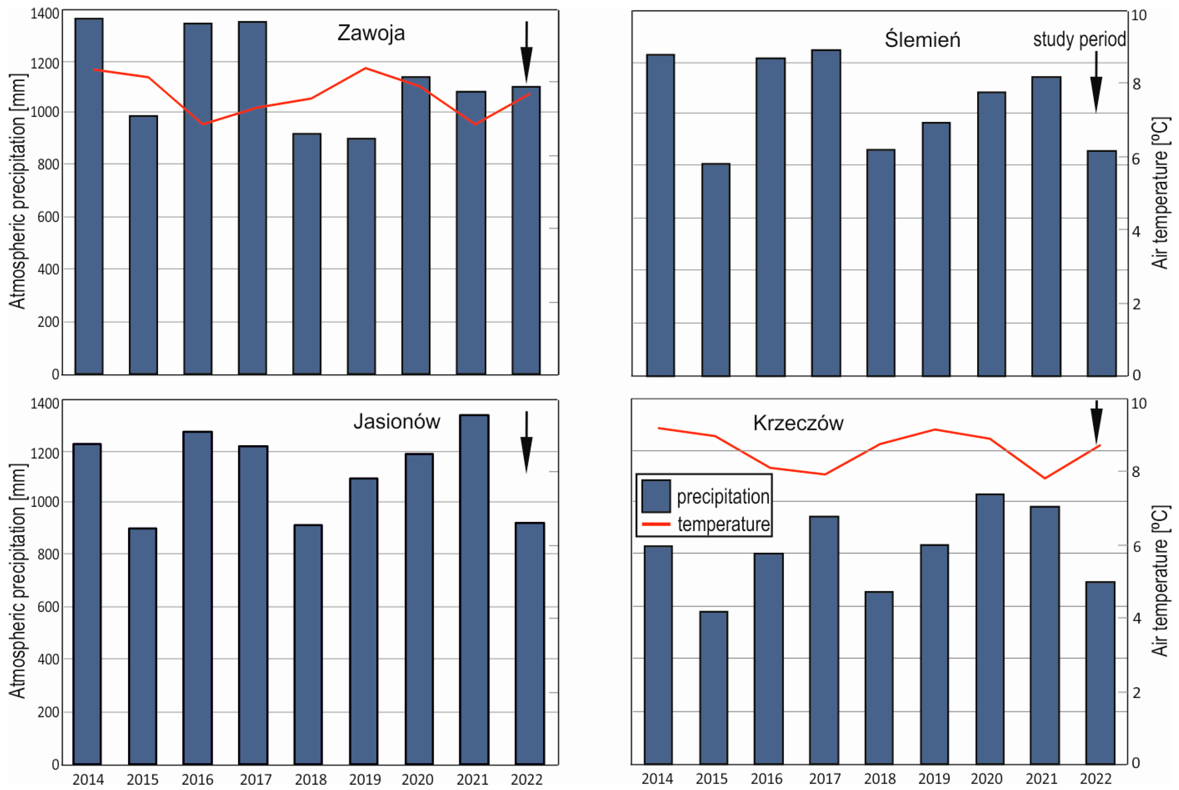
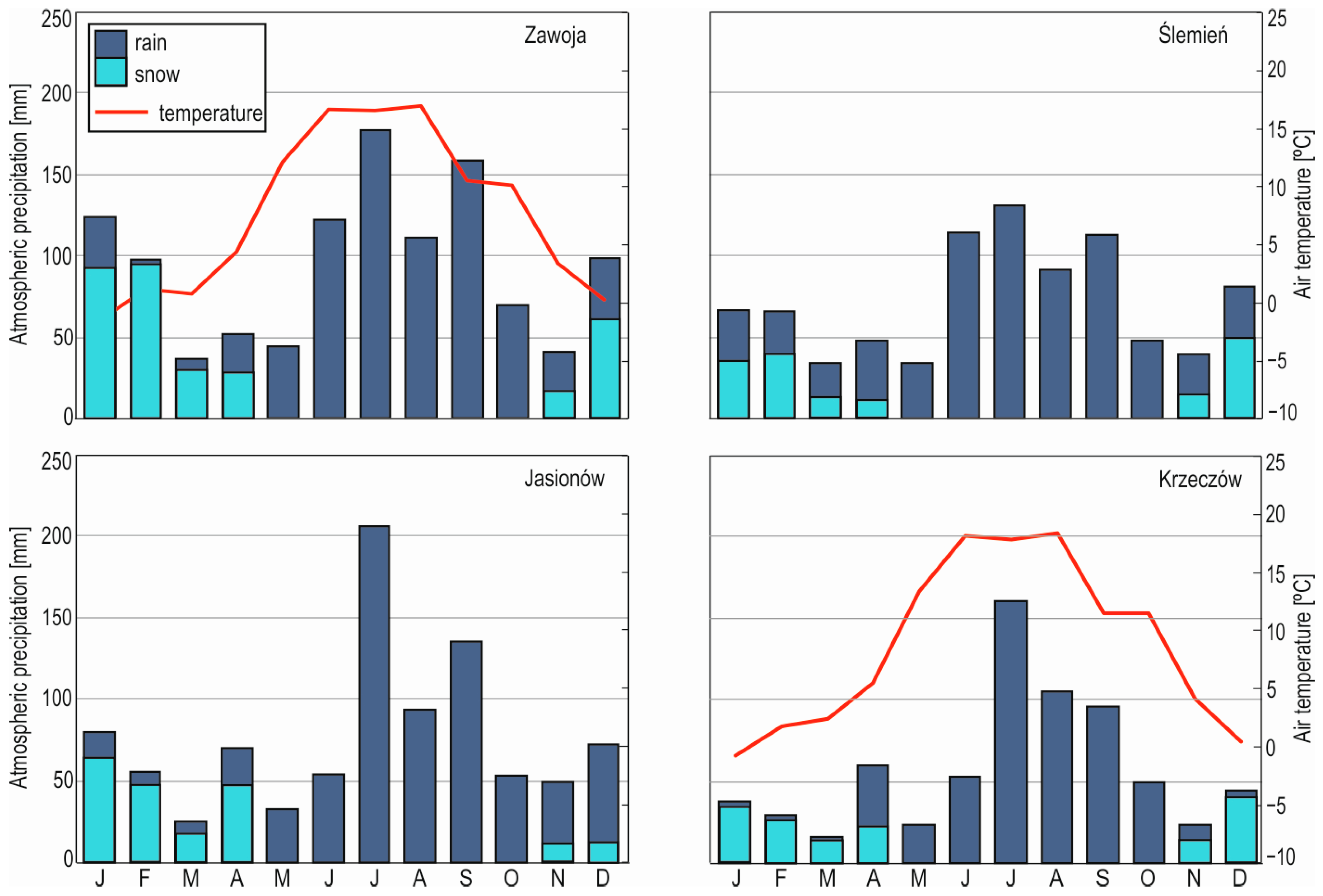
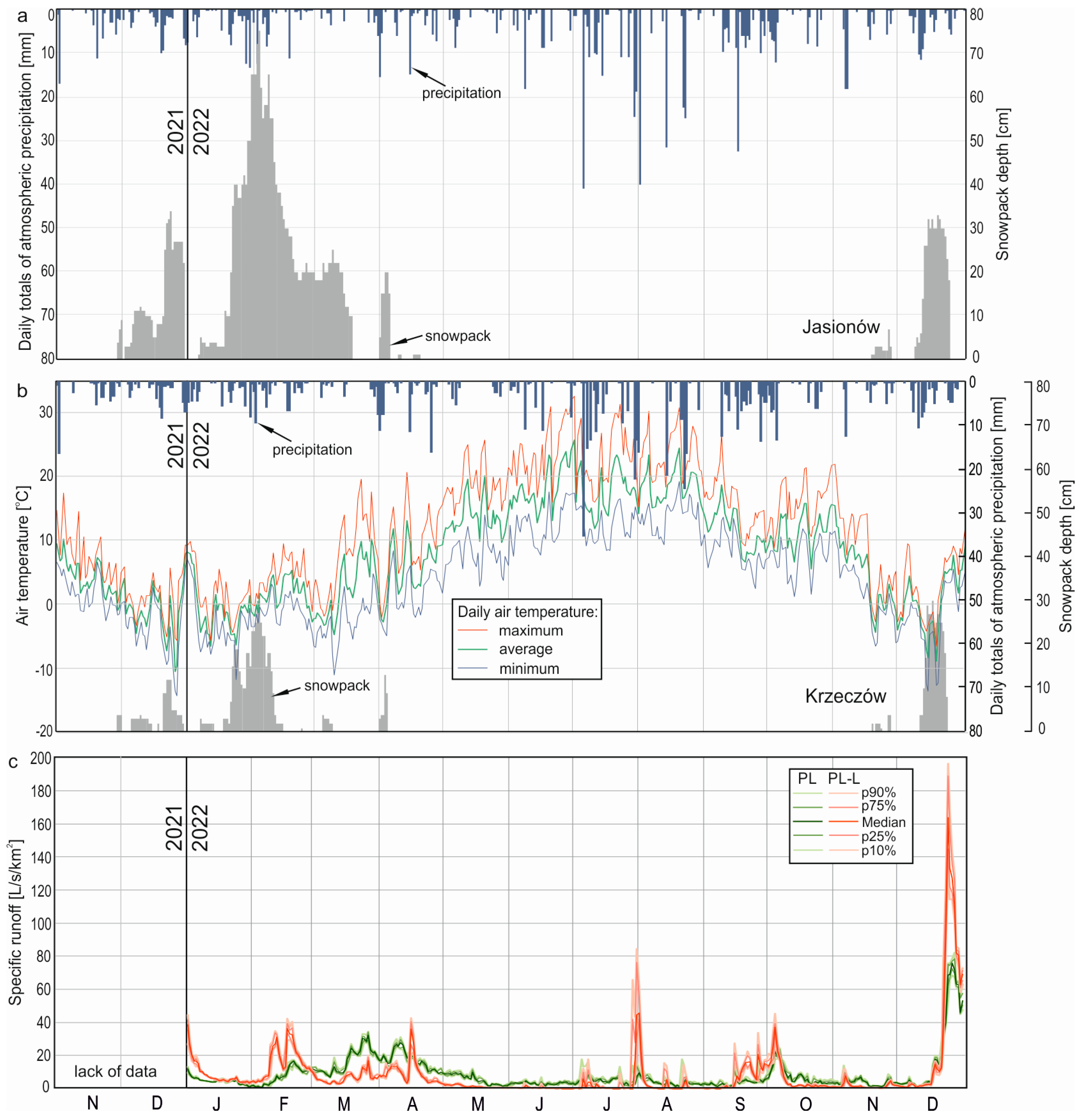
The Hydro-Meteorologic Background of the Study Period

The year 2022 was characterized by lower atmospheric precipitation and higher average annual air temperature compared to the average from 2014 to 2022, as data from the IMGW stations located near the three study areas have shown: in Ślemień near the catchments in the Mały Beskid Mts., in Zawoja near the catchments in the Pasmo Polic Range, and in Jasionów and Krzeczów near the catchments in the Pasmo Lubonia Range (see Figure 1, Figure 4). Higher precipitation occurred in the warmer half of the year (April–September) than in the colder half of the year (October–March) in all the studied areas in 2022, with the highest precipitation in July and the lowest in March (Figure 5). In the colder half of the year, most of the precipitation fell as snow, while in the warmer half of the year, it fell as rain (Figure 5). In 2022, there were two mid-winter snowmelt events, in February and December, and one spring snowmelt event in March and April. In the summer months (June–August), there were several storm rainfall events, and in the autumn months (September–October), there was a long-lasting rainfall event associated with the passage of atmospheric fronts.
In 2022, the average specific runoff was higher in streams draining the Pasmo Polic Range (PP, PP-L), where it ranged from about 12 to 14.5 L/s/km2, than in streams draining the Pasmo Lubonia Range (PL, PL-L) and Mały Beskid Mts. (MB, MB-L), where it ranged from about 8 to 9.5 L/s/km2 (Table 2). The higher specific runoff in the PP and PP-L catchments was associated with higher precipitation—these catchments are located at higher elevations than the other studied catchments (Table 1). However, the specific runoff obtained for the catchments of PP and PP-L in 2022 is still very low compared to the results obtained earlier in this area by other authors. For example, Franczak et al. [50] obtained average specific runoff values of 29.8 and 24.6 L/s/km2 for 2012 and 2013, respectively, in the nearby Kiczorka catchment. Such large differences in specific runoff can be explained partly by the slightly higher elevation of the Kiczorka catchment relative to the PP and PP-L catchments, and consequently higher water inflow to the catchment due to higher amounts of precipitation, and partly by extremely low precipitation and high air temperature values noted in 2022, resulting in large water losses from catchments due to evaporation. Such weather conditions in 2022 resulted in very low runoff coefficients in all catchments, ranging from 28% to 34% (Table 2). The runoff coefficient was slightly lower in the landslide catchment (PL-L) than in the non-landslide catchment (PL) in the Pasmo Lubonia Range, while in the Mały Beskid Mts. and the Pasmo Polic Range, runoff coefficients were higher in the landslide catchments (MB-L and PP-L) than in the non-landslide catchments (MB and PP).

4. Results

4.1. Statistical Characteristics of Specific Runoff in 2022: Landslide Catchments vs. Non-Landslide Catchments

Landslide catchments in the Pasmo Lubonia Range (PL-L) and the Mały Beskid Mts. (MB-L) exhibited a higher share of low specific runoff (<5 L/s/km2) and high specific runoff (>30 L/s/km2) compared to non-landslide PL and MB catchments (Figure 6). The most distinct differences between landslide and non-landslide catchments were observed for a very low specific runoff range, as cumulative frequency curves of specific runoff show (Figure 6). For example, in the Pasmo Lubonia Range, the share of specific runoff below 2.5 L/s/km2 in the PL-L catchment was 50%, while in the PL catchment, it was only 17%. As specific runoff increased, the share of a given specific runoff with lower values (cumulative frequency of specific runoff values) became more similar in the landslide catchment and non-landslide catchment. For instance, the share of specific runoff below 5 L/s/km2 in the PL-L catchment was 65%, while in the PL catchment it was 51%. A greater share of cumulative frequency of a given specific runoff in the PL-L catchment compared to the PL catchment persisted until a specific runoff of 21 L/s/km2 was reached. Above 21 L/s/km2, the cumulative frequency (%) of a given specific runoff was greater in the PL-L catchment than in the PL catchment. In the PL-L catchment, 5% of specific runoff values exceeded 30 L/s/km2, reaching nearly 200 L/s/km2, while in the PL catchment, only 3% of specific runoff exceeded 30 L/s/km2, reaching only 80 L/s/km2.
In the studied catchments of the Mały Beskid Mts., the difference between the share of low and high specific runoff in the studied landslide (MB-L) and non-landslide (MB) catchments was smaller than in the catchments in the Pasmo Lubonia Range (Figure 6). The share of very low specific runoff, below 2.5 L/s/km2, was 29% in the MB-L catchment and 14% in the MB catchment. This difference in the cumulative frequency of a given specific runoff decreased with increasing specific runoff, similar to that observed in the catchments of the Pasmo Lubonia Range (Figure 6). For example, the share of specific runoff values below 5 L/s/km2 for the MB-L catchment was 49%, compared to 39% for the MB catchment. This difference gradually decreased up to a specific runoff of approximately 7.5 L/s/km2. Above 7.5 L/s/km2, the cumulative frequency of a given specific runoff was greater in the MB-L catchment than in the MB catchment. For instance, in the MB-L catchment, 5% of specific runoff exceeded 30 L/s/km2, while in the MB catchment, only 1.5% did.
The situation was different in the studied catchments of the Pasmo Polic Range, where the predominance of very low discharge in the landslide catchment (PP-L) compared to the non-landslide catchment (PP) was negligible. In these catchments, where specific runoff was generally higher than in the catchments of the Pasmo Lubonia Range and the Mały Beskid Mts., since they never fell below 2.4 L/s/km2, the share of low specific runoff equalized very quickly, at a specific runoff of approximately 4.5 L/s/km2 (Figure 6). Above this specific runoff, in the range of 4–60 L/s/km2, the share of higher specific runoff was greater in the PP-L catchment than in the PP catchment, and in the range above 60 L/s/km2, the PP-L catchment again had a greater share of lower specific runoff.

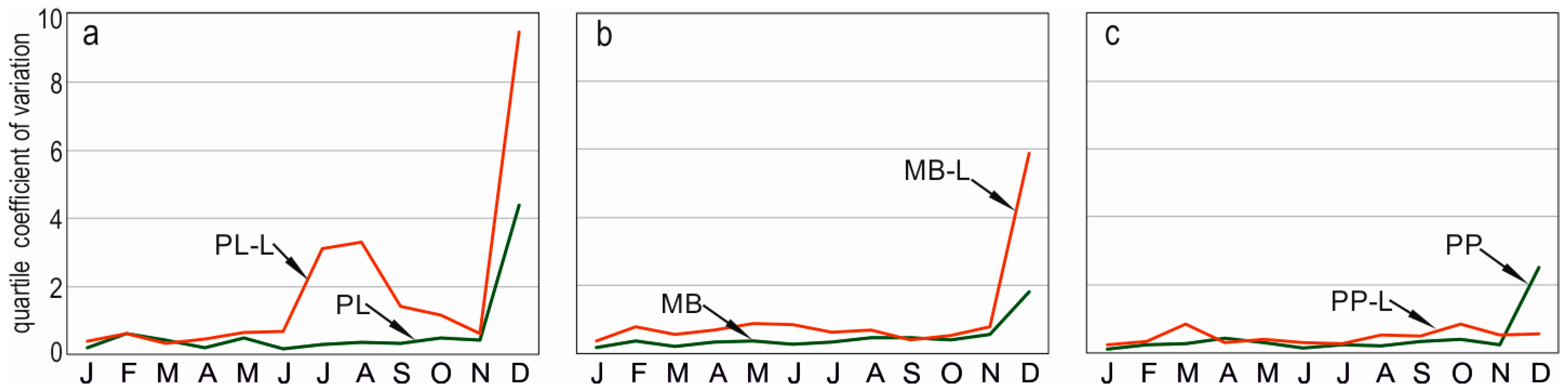
4.2. Specific Runoff Variability Throughout the Year: Landslide Catchments vs. Non-Landslide Catchments

Annual and monthly variability in specific runoff in 2022 was in most cases greater in landslide catchments than in non-landslide catchments in all the studied areas, as the quartile coefficients of variation (Table 2, Figure 7), as well as the quartile and decile ranges (Figure 8), show. However, differences in daily variation in specific runoff occurred between the studied areas, as shown by daily quartile coefficients of variation (Figure 9). The above values for the Pasmo Lubonia Range and Mały Beskid Mts. were generally higher in landslide catchments (PL-L and MB-L) than in non-landslide catchments (PL and MB), particularly during summer storm events. The highest daily specific runoff variability was observed during this period in the PL-L stream. The situation was slightly different in the Pasmo Polic Range catchments, where the daily variability in specific runoff was sometimes lower in the landslide (PP-L) than in non-landslide (PP) catchments, especially during mid-winter snowmelt and summer rainfall events. During these times, specific runoff often reached higher values in the PP catchment than in the PP-L catchment.
Specific runoff during the mid-winter snowmelt in January, February, and December of 2022 was more dynamic in the landslide catchment (PL-L) than in the non-landslide catchment (PL) in the Pasmo Lubonia Range (Figure 10). During this type of snowmelt, specific runoff in the PL-L catchment increased and decreased more rapidly compared to the PL catchment, and reached higher values. Conversely, during spring snowmelt in March, 2022, both streams experienced a gradual increase in specific runoff with higher values in the PL catchment. After the spring snowmelt period, in April, specific runoff in the PL-L stream decreased rapidly, and during dry periods in May, it dried up. This was different in the PL catchment, where specific runoff decreased gradually after the snowmelt period. During summer rainfall events, specific runoff in the PL-L stream exhibited greater daily dynamics than in the PL stream as well. In dry periods, the PL-L stream dried up in 6% of cases throughout the year, while in the PL stream, specific runoff remained at approximately 1.5 L/s/km2 throughout the year.
In the Mały Beskid Mts., higher specific runoff was generally observed in the landslide (MB-L) versus non-landslide (MB) catchments during snowmelt periods, especially during spring snowmelt floods (Figure 11). However, in late spring/early summer (May), after the snowmelt period, specific runoff in the MB-L catchment rapidly decreased to the level of specific runoff in the MB catchment. During summer and autumn dry periods, specific runoff in the MB-L catchment was generally lower than in the MB catchment. Sometimes, during dry periods, in approximately 1% of cases throughout the year, the MB-L stream dried up, while the MB stream never dried up in 2022.
In the studied Pasmo Polic Range catchments, specific runoff during the mid-winter snowmelt in January, February, and December was slightly higher in non-landslide (PP) than in landslide (PP-L) catchments (Figure 12). Conversely, during spring snowmelt, specific runoff was distinctly higher in the PP-L catchment than in the PP catchment. Higher specific runoff in the PP-L catchment persisted until August, when it decreased to the level of specific runoff in the PP catchment. During summer, daily variability in specific runoff in the PP-L catchment was similar to that in the PP catchment, as indicated by daily quartile coefficients of variation. Some rainfall events produced less dynamic changes in specific runoff in the PP-L catchment than in the PP catchment. During dry periods in late summer and autumn, specific runoff in the PP-L catchment was slightly lower than in the PP catchment. From August to November, the PP-L catchment had almost twice as many cases of specific runoff below 5 L/s/km2 as the PP catchment, accounting for 3.9% and 6.3%, respectively. The main findings regarding differences in stream runoff variability between landslide catchments and non-landslide catchments are summarized in Table 3.

5. Discussion

The results presented herein indicate that the presence of landslides in the studied catchments affects the variability of stream runoff over the course of the year by increasing its variability. However, the degree of change in stream runoff depends on catchment lithology and landslide characteristics. This is consistent with the assertion by Krzeminska et al. [31] that hydrologic material properties and the structure of landslides strongly control the groundwater recharge of landslides. The presented research material demonstrates that these characteristics also control the water outflow from landslides. The largest differences in the variability of runoff between landslide and non-landslide catchments occur in areas where the lithology of the landslide catchment is dominated by shale, and landslides are numerous, although relatively small, ranging up to 0.7 km2 (i.e., Pasmo Lubonia Range). Smaller differences in runoff variability occur in areas where thin-bedded sandstone is predominant, and one-third of the given catchment area with landslides is occupied by a single large landslide with an area of about 0.25 km2 (the Mały Beskid Mts.). The smallest differences in runoff variability occur in areas formed of thick-bedded sandstone (i.e., Pasmo Polic Range), where the landslide catchment is found entirely within one very large landslide area of 1.63 km2. The variability of runoff over the course of the year resulted from the water storage capacity of the catchment: the smaller the storage capacity, the greater the runoff variability in the catchment [51,52,53].
The very low water storage capacity of the landslide-affected catchment in the Pasmo Lubonia Range (PL-L) is not only due to the high share of poorly permeable shale in the lithology [48,54], but also due to the nature of local landslides. In the upper sandstone part of the PL-L catchment, there are several relatively small (up to 0.07 km2) and shallow (up to a dozen or so meters in depth) landslides [43,44,45]. Shallow landslide depths indicate the shallow occurrence of poorly permeable shale in bedrock, which forms the landslide sliding surface. The shallow depth of landslides is also associated with the shallow depth of various types of fractures, which play an important role in water circulation in landslide areas [31,55,56]. The system of shallow fractures provides an efficient pathway for the drainage of rainwater and meltwater into the landslide [30,57]. Hence, the system of shallow fractures together with a shallow occurrence of poorly permeable shale result in a shallow, and therefore rapid, water circulation pattern in PL-L catchments (Figure 13a). According to Hale et al. [58], Hale and McDonnell [59], Pfister et al. [60], and Burt et al. [61], water transit times decrease with an increase in the share of impermeable bedrock in catchments. Furthermore, the rapid hydrologic response of the landslide-affected PL-L catchment to snowmelt and rainfall indicates good hydraulic contact between fissures—according to Krzeminska et al. [31], a connected network of fissures in the landslide body results in fast preferential drainage, referred to as preferential fissure flow [55].
Very small (up to 0.005 km2 of area) and very shallow (up to a few meters of depth) landslides in the middle and lower shale parts of the PL-L catchment, however, exhibit less water storage capacity compared to those in the upper sandstone part because of lower permeability of bedrock and a shallower system of fissures. This results in a more rapid stream runoff response to mid-winter snowmelt events generated mainly in the middle and lower parts of the studied catchment than to spring snowmelt generated mainly in the upper sandstone part of the PL-L catchment. Mid-winter thaws lead to a complete disappearance of snow cover in the lower part of the catchment, unlike the upper part, due to larger air temperature increases. This is consistent with the findings by Pfister et al. [60]: the higher the bedrock permeability, the larger the water storage, and therefore the more damped the high-flow peaks.
The limited water storage capacity of the landslide catchment in the Pasmo Lubonia Range also results in rapid declines or even the cessation of runoff following the snowmelt period. The landslide PL-L catchment has an extremely low ability to store water from melting snow. Its ability to gradually supply water to the streambed is also limited. In contrast, the non-landslide PL catchment is mostly composed of thick-bedded sandstone and conglomerates and has a significant ability to store water from melting snow. This water is gradually drained after snowmelt events, leading to more stable stream runoff in late spring and summer. Snowmelt recharge of groundwater plays an important role in sustaining the baseflow of mountainous streams [62,63]. The studied landslide PL-L catchment exhibits sharp increases and decreases in runoff during summer storm events. This suggests that there is a rapid delivery of rainwater to the streambed via a system of connected shallow landslide fissures, causing a sudden increase in runoff—forest cover makes overland flow in the catchment significantly limited. When rainfall stops, runoff decreases rapidly and may cease entirely after a few rain-free days. Consequently, the landslide PL-L catchment experiences a significant proportion of very low and very high runoff ranges compared to the non-landslide PL catchment.
The water storage capacity of the landslide catchment in the Mały Beskid Mts. (MB-L) is much greater compared to that of the landslide catchment in the Pasmo Lubonia Range (PL-L) due to two main factors. One factor is lithology; the MB-L catchment consists mainly of rather strongly permeable thin-bedded sandstone, while the PL-L catchment contains a high share of poorly permeable shale. Furthermore, the nature of landslides differs between the two catchments. In the upper part of the MB-L catchment, there is one relatively large landslide with a several-times-larger surface area compared to the largest landslide found in the PL-L catchment. This larger surface area results in the landslide having a greater depth, which is estimated to be 23–27 m [43,44]. The greater the depth of the landslide, the deeper system of fissures, and hence, the greater water storage capacity of the MB-L catchment compared to the PL-L catchment (Figure 13b). However, despite the greater water storage capacity of the MB-L catchment compared to the PL-L catchment, it is still lower than in the non-landslide catchment in the Mały Beskid Mts. (MB)—water circulation in the MB-L catchment is faster compared to the non-landslide MB catchment. This is probably due to the presence of a system of connected landslide fissures accelerating water flow in the landslide catchment. In the non-landslide catchment during rainfall or snowmelt events, water infiltrates the O horizon, which is typical for forested areas, and gradually percolates into lower soil horizons. The presence of the high-water-storage-capacity O horizon in forested catchments prevents surface runoff from forming, as documented by researchers such as Hümann et al. [64] and Neris et al. [65]. In the landslide catchment, rainfall and snowmelt water also initially infiltrate the O horizon and horizons just beneath; however, the presence of fissures allows the water to drain quickly. The fissure preferential flow accelerates the movement of water in the landslide catchment compared to the slower percolation of water in the non-landslide catchment. Quick rainfall or snowmelt percolation probably results in smaller evaporation losses in landslide catchments with deep fissures than in non-landslide catchments, as indicated by the higher runoff coefficients in the MB-L and PP-L catchments (Table 2). The shallower the system of connected fissures, the shorter the water transit time, and the lower the water retention capacity. This is evident in the rate of runoff decline after the spring snowmelt period, which is faster in the MB-L catchment compared to the MB catchment, but slower compared to the PL-L catchment. Similarly, the proportion of low and high runoff ranges is higher in the MB-L catchment compared to the MB catchment, but lower compared to the PL-L catchment.
Among the three investigated landslide catchments, the PP-L catchment found in the Pasmo Polic Range exhibits the highest water storage capacity. This catchment features a large landslide (1.63 km2) formed in strongly fractured thick-bedded sandstone [34]. The size of this landslide indicates its great depth, estimated to be 64–66 m [43,44]. The high permeability of thick-bedded sandstone combined with a dense and deep system of landslide fissures result in the deep water circulation and high storage capacity of the PP-L catchment compared to the PL-L and MB-L landslide catchments (Figure 13c). This is evidenced by a distinctly slower decline in stream runoff in the PP-L catchment after a period of high snowmelt runoff compared to the PL-L and MB-L catchments: in the PP-L catchment, stream runoff reached low values as late as August, whereas in the MB-L catchment, this occurred in June, and in the PL-L catchment, it occurred as early as April. The monthly variability of runoff in the PP-L landslide catchment seems to be slightly greater than in the non-landslide PP catchment. This is primarily due to slightly faster water drainage during snowmelt months and immediately afterward in the PP-L landslide catchment compared to the studied non-landslide PP catchment. This indicates only slightly lower water storage capacity in the landslide PP-L catchment relative to the non-landslide PP catchment. However, daily runoff variability in the PP-L catchment was sometimes lower than in the PP catchment, especially during short summer rainstorm events. This requires detailed studies involving hydrogeochemical and isotopic analyses of stream water during selected rainfall events under different antecedent conditions. Buczek [35] conducted research in the nearby Gorce Mts. (Outer Carpathians) with a similar lithology to that of the Pasmo Polic Range and observed distinctly smaller stream runoff variability in the landslide catchment than in a control catchment without landslides. Buczek [35] explained this fact by the greater water storage capacity of the landslide catchment resulting from the high permeability of a strongly fractured landslide body, and the presence of numerous flat or concave forms of surface relief favoring the infiltration of rainfall and snowmelt water into the soil. Presumably, the difference in the stream runoff variation, hence water storage capacity of the catchment studied by Buczek [35], and the PP-L catchment resulted from the difference in the share of these relief forms in the studied catchment areas.
The presented study on the role of landslides in determining runoff variability in the Carpathian catchments is based on hydrometric measurements. In the future, this study should be supplemented by (1) geophysical studies (Electrical Resistivity Tomography), which would allow us to gain new information about the hydrologic properties of landslide bodies and the depth of the sliding surface, and (2) isotopic and hydrogeochemical studies that would enable us to obtain detailed information about water circulation patterns in catchments with landslides with different characteristics.

6. Conclusions

The herein presented research data demonstrate that the presence of landslides in a catchment affects the variability of stream water runoff throughout the year—it increased stream runoff variability in all three study areas, albeit to varying degrees. The degree of increased variability of stream runoff depends on catchment lithology and the properties of local landslides. The greatest variability in stream runoff occurred in a catchment where shale dominates the lithology (i.e., Pasmo Lubonia Range), and landslides are numerous but relatively small (up to 0.7 km2). Smaller differences in stream water runoff variability occurred in an area dominated by thin-bedded sandstone (i.e., Mały Beskid Mts.), where one large landslide (0.25 km2) covers approximately one third of the studied catchment area. The smallest differences occurred in an area formed mainly of thick-bedded sandstone (i.e., Pasmo Polic Range), where the landslide catchment is found entirely within one very large landslide (1.63 km2), extending beyond the catchment area. Hence, the variability of stream runoff depends on the permeability of the bedrock and the size of the landslides, which determines the depth of the sliding surface and landslide fissures. The herein described research indicates that the larger the area of a landslide, the deeper the system of interconnected landslide fissures in the catchment, and the longer the water transit time, and the greater the water storage capacity of the catchment. All of this contributes to a smaller variability of stream runoff throughout the year.

Funding

This project was funded by the National Science Centre of Poland (Project No.: DEC-2021/05/X/ST10/01138 Miniatura-5). This research has been supported by a grant from the Priority Research Area (Anthropocene) under the Strategic Programme Excellence Initiative at Jagiellonian University (Project No.: U1U/W23/NO/03.72). This publication has been supported by a grant from the Faculty Geography and Geology under the Strategic Programme Excellence Initiative at Jagiellonian University (Project No.: U1U/W23/NO/06).

Data Availability Statement

The data presented in this study are available on request from the author.

Conflicts of Interest

The author declare no competing interests.

References

  1. Alexandrowicz, Z.; Margielewski, W. Impact of mass movements on geo- and biodiversity in the Polish Outer (Flysch) Carpathians. Geomorphology 2010, 123, 290–304. [Google Scholar] [CrossRef]
  2. Margielewski, W. O strukturalnych uwarunkowaniach rozwoju głębokich osuwisk—Implikacje dla Karpat fliszowych. Prz. Geol. 2001, 49, 515–524. [Google Scholar]
  3. Chowaniec, J.; Wójcik, A. Osuwiska w Województwie Małopolskim; Państwowy Instytut Geologiczny—Państwowy Instytut Badawczy: Kraków, Poland, 2012; pp. 1–72. [Google Scholar]
  4. Rączkowski, W. Landslide hazard in the Polish flysh Carpathians. Stud. Geomorph. Carpatho-Balc. 2007, 41, 61–75. [Google Scholar]
  5. Giorgi, F.; Raffaele, F.; Coppola, E. The response of precipitation characteristics to global warming from climate projections. Earth Syst. Dynam. 2019, 10, 73–89. [Google Scholar] [CrossRef]
  6. Chen, H.; Dadson, S.; Chi, Y. Recent rainfall-induced landslides and debris flow innorthern Taiwan. Geomorphology 2006, 77, 112–125. [Google Scholar] [CrossRef]
  7. Davies, T.R.; McSaveney, M.J. The role of rock fragmentation in the motion of large landslides. Eng. Geol. 2009, 109, 67–79. [Google Scholar] [CrossRef]
  8. Carlini, M.; Chelli, A.; Vescovi, P.; Artoni, A.; Clemenzi, L.; Tellini, C.; Torelli, L. Tectonic control on the development and distribution of large landslides in the Northern Apennines (Italy). Geomorphology 2015, 253, 425–437. [Google Scholar] [CrossRef]
  9. Cui, S.; Yang, Q.; Zhu, L.; Pei, X.; Wang, S.; Liang, J. The role of tectonic discontinuities in triggering large seismic landslides. Lithosphere 2022, 7, 3196788. [Google Scholar] [CrossRef]
  10. Keefer, D.K. Landslides caused by earthquakes. Geol. Soc. Am. Bull. 1984, 95, 406–421. [Google Scholar] [CrossRef]
  11. Khazai, B.; Sitar, N. Evaluation of factors controlling earthquake-induced landslides caused by Chi-Chi earthquake and comparison with the Northridge and Loma Prieta events. Eng. Geol. 2004, 71, 79–95. [Google Scholar] [CrossRef]
  12. Dunning, S.A.; Mitchell, W.A.; Rosser, N.J.; Petley, D.N. The Hattian Bala rock avalanche and associated landslides triggered by the Kashmir Earthquake of 8 October 2005. Eng. Geol. 2007, 93, 130–144. [Google Scholar] [CrossRef]
  13. Dai, F.C.; Xu, C.; Yao, X.; Xu, L.; Tu, X.B.; Gong, Q.M. Spatial distribution of landslides triggered by the 2008 Ms 8.0 Wenchuan earthquake, China. J. Asian Earth Sci. 2011, 40, 883–895. [Google Scholar] [CrossRef]
  14. Saito, H.; Nakayama, D.; Matsuyama, H. Relationship between the initiation of a shallow landslide and rainfall intensity—Duration thresholds in Japan. Geomorphology 2010, 118, 167–175. [Google Scholar] [CrossRef]
  15. Huang, J.; Ju, N.P.; Liao, Y.J.; Liu, D.D. Determination of rainfall thresholds for shallow landslides by a probabilistic and empirical method. Nat. Hazard Earth Syst. 2015, 15, 2715–2723. [Google Scholar] [CrossRef]
  16. Larsen, M.C.; Simon, A. A rainfall intensity-duration threshold for landslides in a humid-tropical environment, Puerto Rico. Geogr. Ann. A 2017, 75, 13–23. [Google Scholar] [CrossRef]
  17. Peruccacci, S.; Brunetti, M.T.; Gariano, S.L.; Melillo, M.; Rossi, M.; Guzzetti, F. Rainfall thresholds for possible landslide occurrence in Italy. Geomorphology 2017, 290, 39–57. [Google Scholar] [CrossRef]
  18. Bogaard, T.A.; Greco, R. Landslide hydrology: From hydrology to pore pressure. WIREs Water 2016, 3, 439–459. [Google Scholar] [CrossRef]
  19. Liang, W.-L. Hydrological responses in a natural forested headwater before and after subsurface displacement. J. Hydrol. 2020, 591, 125529. [Google Scholar] [CrossRef]
  20. Iverson, R.M.; Major, J.J. Rainfall, ground-water flow, and seasonal movement at Minor Creek landslide, nordwesterrn California: Physical interpretation of empirical relations. Geol. Soc. Am. Bull. 1987, 99, 579–594. [Google Scholar] [CrossRef]
  21. Berti, M.; Simoni, A. Observation and analysis of near-surface pore-pressure measurements in clay-shales slopes. Hydrol. Process. 2012, 26, 2187–2205. [Google Scholar] [CrossRef]
  22. Binet, S.; Jomard, H.; Lebourg, T.; Guglielmi, Y.; Tric, E.; Bertrand, C.; Mudry, J. Experimental analysis of groundwater flow through a landslide slip surface using natural and artificial water chemical tracers. Hydrol. Process. 2007, 21, 3463–3472. [Google Scholar] [CrossRef]
  23. Van Asch, T.W.J.; Hendriks, M.R.; Hessel, R.; Rappange, F.E. Hydrological triggering conditions of landslides in varved clays in the French Alps. Eng. Geol. 1996, 42, 239–251. [Google Scholar] [CrossRef]
  24. Van Asch, T.W.J.; Buma, J.; van Beek, L.P.H. A view on some hydrological triggering systems in landslides. Geomorphology 1999, 30, 25–32. [Google Scholar] [CrossRef]
  25. Van Asch, T.W.J.; Buma, J. Modelling groundwater fluctuations and the frequency of movement of a landslide in the Terres Noires region of Barcelonnette (France). Earth Surf. Proc. Land. 1997, 22, 131–141. [Google Scholar] [CrossRef]
  26. Uchida, T.; Kosugi, K.; Mizuyama, T. Effects of pipe flow and bedrock groundwater on runoff generation in a steep headwater catchment in Ashiu, central Japan. Water Resour. Res. 2002, 38, 1119. [Google Scholar] [CrossRef]
  27. De Montety, V.; Marc, V.; Emblanch, C.; Malet, J.-P.; Bertrand, C.; Maquaire, O.; Bogaard, T. Identifying origin of groundwater and flow processes in complex landslides affecting black marls in southern French Alps: Insights from an hydrochemistry survey. Earth Surf. Proc. Land. 2007, 32, 32–48. [Google Scholar] [CrossRef]
  28. Bièvre, G.; Jongmans, D.; Winiarski, T.; Zumbo, V. Application of geophysical measurements for assessing the role of fissures in water infiltration within a clay landslide (Trièves area, French Alps). Hydrol. Process. 2011, 26, 2128–2142. [Google Scholar] [CrossRef]
  29. Garel, E.; Marc, V.; Ruy, S.; Cognard-Plancq, A.L.; Klotz, S.; Emblanch, C.; Simler, R. Large scale rainfall simulation to investigate infiltration processes in a small landslide under dry initial conditions: The Draix hillslope experiment. Hydrol. Process 2012, 26, 2171–2186. [Google Scholar] [CrossRef]
  30. Van der Spek, J.E.; Bogaard, T.A.; Bakker, M. Characterization of groundwater dynamics in landslides in varved clays. Hydrol. Earth Syst. Sci. 2013, 17, 2171–2183. [Google Scholar] [CrossRef]
  31. Krzeminska, D.M.; Bogaard, T.A.; Malet, J.-P.; van Beek, L.P.H. A model of hydrological and mechanical feedbacks of preferential fissure flow in a slow-moving landslide. Hydrol. Earth Syst. Sci. 2013, 17, 947–959. [Google Scholar] [CrossRef]
  32. Margielewski, W. Records of the Late Glacial–Holocene palaeoenvironmental changes in landslide forms and deposits ofthe Beskid Makowski and Beskid Wyspowy Mts. area (Polish Outer Carpathians). Folia Quat. 2006, 76, 1–149. [Google Scholar]
  33. Margielewski, W. Torfowiska osuwiskowe polskich Karpat fliszowychjako czuły indykator zmian paleośrodowiskapóźnego glacjału i holocenu. Stud. Limnol. Telmatologica 2014, 8, 37–55. [Google Scholar]
  34. Zatorski, M.; Franczak, P.; Buczek, K.; Strzyżowski, D.; Witkowski, K. Rzeźba terenu i jej współczesne przemiany. In Police: Pasmo w Cieniu Babiej Góry; Franczak, P., Ed.; Instytut Geografii i Gospodarki Przestrzennej Uniwersytetu Jagiellońskiego: Kraków, Poland, 2017; pp. 31–64. [Google Scholar]
  35. Buczek, K. Wpływ Osuwisk na Stosunki Wodne Stoku oraz Charakter Odpływu ze Zlewni na Przykładzie Gorców. Ph.D. Thesis, Instytut Geografii i Gospodarki Przestrzennej Uniwersytetu Jagiellońskiego, Kraków, Poland, 2024. [Google Scholar]
  36. Malet, J.-P.; van Asch, T.W.J.; van Beek, R.; Maquaire, O. Forecasting the behaviour of complex landslides with a spatially distributed hydrological model. Nat. Hazard Earth Syst. 2005, 5, 71–85. [Google Scholar] [CrossRef]
  37. Oszczypko, N. Budowa geologiczna. In Karpaty Polskie; Warszyńska, J., Ed.; Uniwersytet Jagielloński: Kraków, Poland, 1995; pp. 15–22. [Google Scholar]
  38. Solon, J.; Borzyszkowski, J.; Bidłasik, M.; Richling, A.; Badora, K.; Balon, J.; Brzezińska-Wójcik, T.; Chabudziński, Ł.; Dobrowolski, R.; Grzegorczyk, I.; et al. Physico-geographical mesoregions of Poland: Verification and adjustment of boundaries on the basis of contemporary spatial data. Geogr. Pol. 2018, 91, 143–170. [Google Scholar] [CrossRef]
  39. Długosz, M. Podatność stoków na osuwanie w polskich Karpatach fliszowych. Pr. Geogr. 2011, 230, 1–112. [Google Scholar]
  40. Ryłko, W.; Paul, Z. Szczegółowa Mapa Geologiczna Polski 1:50000, Arkusz Lachowice 1013. 2013. Available online: https://mapy.geoportal.gov.pl/imap/Imgp_2.html?gpmap=gp0 (accessed on 21 July 2023).
  41. Larsen, I.; Montgomery, D.; Korup, O. Landslide erosion controlled by hillslope material. Nat. Geosci. 2010, 3, 247–251. [Google Scholar] [CrossRef]
  42. Guzzetti, F.; Ardizzone, F.; Cardinali, M.; Rossi, M.; Valigi, D. Landslide volumes and landslide mobilization rates in Umbria, central Italy. Earth Planet. Sci. Lett. 2009, 279, 222–229. [Google Scholar] [CrossRef]
  43. Hovius, N.; Stark, C.P.; Allen, P.A. Sediment flux from a mountain belt derived by landslide mapping. Geology 1997, 25, 231–234. [Google Scholar] [CrossRef]
  44. Meier, C.; Jaboyedoff, M.; Derron, M.H.; Gerber, C. A method to assess the probability of thickness and volume estimates of small and shallow initial landslide ruptures based on surface area. Landslides 2020, 17, 975–982. [Google Scholar] [CrossRef]
  45. Website The Polish Geological Institute—National Research Institute. Available online: https://geoportal.pgi.gov.pl/portal/page/portal/SOPO/Wyszukaj3 (accessed on 10 July 2023).
  46. Trzepla, M. Objaśnienia do Mapy Osuwisk i Terenów Zagrożonych Ruchami Masowymi, Skala 1:10000. Gmina Bystra-Sidzina; Państwowy Instytut Geologiczny—Państwowy Instytut Badawczy: Warszawa, Poland, 2010; pp. 1–24. [Google Scholar]
  47. Książkiewicz, M. Szczegółowa Mapa Geologiczna Polski 1:50000, Arkusz Zawoja 1031. 1971. Available online: https://mapy.geoportal.gov.pl/imap/Imgp_2.html?gpmap=gp0 (accessed on 20 July 2023).
  48. Paul, Z.; Ryłko, W. Szczegółowa Mapa Geologiczna Polski 1:50000, Arkusz Rabka 1032. 1986. Available online: https://mapy.geoportal.gov.pl/imap/Imgp_2.html?gpmap=gp0 (accessed on 18 July 2023).
  49. Wojciechowski, T.; Lewandowski, J. Objaśnienia do Mapy Osuwisk i Terenów Zagrożonych Ruchami Masowymi, Gmina Rabka, Skala 1:10000; Państwowy Instytut Geologiczny—Państwowy Instytut Badawczy: Warszawa, Poland, 2010; pp. 1–33. [Google Scholar]
  50. Franczak, P.; Hudyka, M.; Buczek, K.; Górnik, M. Zróżnicowanie przestrzenne i zmienność odpływu w zlewniach fliszowych na obszarze Masywu Babiej Góry. Ann. Univ. Mariae Curie-Sklodowska Sect. B—Geogr. Geol. Mineral. Petrogr. 2015, 70, 95–116. [Google Scholar] [CrossRef]
  51. Dynowska, I. Wody. In Karpaty Polskie; Warszyńska, J., Ed.; Uniwersytet Jagielloński: Kraków, Poland, 1995; pp. 49–67. [Google Scholar]
  52. Berghuijs, W.R.; Hartmann, A.; Woods, R.A. Streamflow sensitivity to water storage changes across Europe. Geophys. Res. Lett. 2016, 43, 1980–1987. [Google Scholar] [CrossRef]
  53. Carlier, C.; Wirth, S.B.; Cochand, F.; Hunkeler, D.; Brunner, P. Geology controls streamflow dynamics. J. Hydrol. 2018, 566, 756–769. [Google Scholar] [CrossRef]
  54. Neuzil, C.E. Permeability of Clays and Shale. Annu. Rev. Earth Planet. Sci. 2019, 47, 247–273. [Google Scholar] [CrossRef]
  55. Krzeminska, D.M.; Bogaard, T.A.; van Asch, T.W.J.; van Beek, L.P.H. A conceptual model of the hydrological influence of fissures on landslide activity. Hydrol. Earth Syst. Sci. 2012, 16, 1561–1576. [Google Scholar] [CrossRef]
  56. Brönnimann, C.; Stähli, M.; Schneider, P.; Seward, L.; Springman, S.M. Bedrock exfiltration as a triggeringmechanism for shallow landslides. Water Resour. Res. 2013, 49, 5155–5167. [Google Scholar] [CrossRef]
  57. Van Woerden, J. The Role of Fissures in the Hydrology and Stability of the Hollin Hill Landslide. Master’s Thesis, Utrecht University, Utrecht, The Netherlands, 2014. [Google Scholar]
  58. Hale, V.C.; McDonnell, J.J.; Stewart, M.K.; Solomon, D.K.; Doolitte, J.; Ice, G.G.; Pack, R.T. Effect of bedrock permeability on stream base flow mean transit time scaling relationships: 2. Process study of storage and release. Water Resour. Res. 2016, 52, 1375–1397. [Google Scholar] [CrossRef]
  59. Hale, V.C.; McDonnell, J.J. Effect of bedrock permeability on stream base flow mean transit time scaling relations: 1. A multiscale catchment intercomparison. Water Resour. Res. 2016, 52, 1358–1374. [Google Scholar] [CrossRef]
  60. Pfister, L.; Martínez-Carreras, N.; Hissler, C.; Klaus, J.; Carrer, G.E.; Stewart, M.K.; McDonnell, J.J. Bedrock geology controls on catchment storage, mixing, and release: A comparative analysis of 16 nested catchments. Hydrol. Process. 2017, 31, 1828–1845. [Google Scholar] [CrossRef]
  61. Burt, E.I.; Coayla Rimachi, D.H.; Ccahuana Quispe, A.J.; Atwood, A.; West, A.J. Isotope-derived young water fractions in streamflow across the tropical Andes mountains and Amazon floodplain. Hydrol. Earth Syst. Sci. 2023, 27, 2883–2898. [Google Scholar] [CrossRef]
  62. Hood, J.L.; Hayashi, M. Characterization of snowmeltflux and groundwater storage in an alpine headwater basin. J. Hydrol. 2015, 521, 482–497. [Google Scholar] [CrossRef]
  63. Carroll, R.W.H.; Deems, J.S.; Niswonger, R.; Schumer, R.; Williams, K.H. The importance of interflow to groundwater recharge in a snowmelt-dominated headwater basin. Geophys. Res. Lett. 2019, 46, 5899–5908. [Google Scholar] [CrossRef]
  64. Hümann, M.; Schüler, G.; Müller, C.; Schneider, R.; Johst, M.; Caspari, T. Identification of runoff processes—Impact of different forest types and soil properties on soil-water interrelations and floods. J. Hydrol. 2011, 409, 637–649. [Google Scholar] [CrossRef]
  65. Neris, J.; Tejedor, M.; Rodríguez, M.; Fuentes, J.; Jiménez, C. Effect of forest floor characteristics on water repellency, infiltration, runoff and soil loss in Andisols of Tenerife (Canary Islands, Spain). Catena 2013, 108, 50–57. [Google Scholar] [CrossRef]
Figure 1. Study area. The location of three research areas (the Mały Beskid Mts., the Pasmo Polic Range, and the Pasmo Lubonia Range) in the Carpathian Mountains (a). Geological (b) and LiDAR (c) maps of the studied landslide catchments (MB-L, PP-L, and PL-L) and non-landslide catchments (MB, PP, and PL).
Water 17 00190 g001
Figure 2. Cross-sections and estimated depths of landslides in the Mały Beskid Mountains (MB-L catchment), the Pasmo Polic Range (PP-L catchment), and the Pasmo Lubonia Range (PL-L catchment). The locations of the cross-sections are shown in Figure 1.
Water 17 00190 g002
Figure 3. The weirs with two V-notches installed at the outlet of the studied streams allowed for precise volumetric discharge measurements during low-flow periods (a) and medium-flow periods, up to about 30 L/s/km2 (b). (c) The staff gauge and the tube with an automatic stream water level device (example from the PP-L catchment in the photo by J.P. Siwek).
Water 17 00190 g003
Figure 4. Annual atmospheric precipitation totals and average air temperature at Zawoja, Ślemień, Jasionów, and Krzeczów meteorologic stations in 2014–2022 (lack of air temperature data at Ślemień and Jasionów).
Water 17 00190 g004
Figure 5. Monthly atmospheric precipitation totals in the form of rain and snow, and average air temperature at Zawoja, Ślemień, Jasionów, and Krzeczów meteorologic stations in 2022 (lack of air temperature data at Ślemień and Jasionów).
Water 17 00190 g005
Figure 6. Cumulative frequencies (%) and histograms of specific runoff values in streams draining landslide (PL-L, MB-L, PP-L) and non-landslide (PL, MB, PP) catchments in the Pasmo Lubonia Range (a), the Mały Beskid Mts. (b), and the Pasmo Polic Range (c). The dashed lines indicate the specific runoff values at which the cumulative frequencies of specific runoff are the same in landslide and non-landslide catchments.
Water 17 00190 g006
Figure 7. Monthly quartile coefficient of variation in specific runoff in streams draining landslide (PL-L, MB-L, PP-L) and non-landslide (PL, MB, PP) catchments in the Pasmo Lubonia Range (a), the Mały Beskid Mts. (b), and the Pasmo Polic Range (c).
Water 17 00190 g007
Figure 8. Monthly median, quartile, and decile values of specific runoff in streams draining landslide (PL-L, MB-L, PP-L) and non-landslide (PL, MB, PP) catchments in the Pasmo Lubonia Range (a), the Mały Beskid Mts. (b), and the Pasmo Polic Range (c).
Water 17 00190 g008
Figure 9. Daily quartile coefficient of variation in specific runoff in streams draining landslide (PL-L, MB-L, PP-L) and non-landslide (PL, MB, PP) catchments in the Pasmo Lubonia Range (a), the Mały Beskid Mts. (b), and the Pasmo Polic Range (c).
Water 17 00190 g009
Figure 10. Meteorological conditions at Jasionów (a) and Krzeczów (b) meteorological stations two months before and when studied in 2022. Daily medians, quartiles, and deciles of specific runoff in streams draining landslide (PL-L) and non-landslide (PL) catchments in the Pasmo Lubonia Range (c).
Water 17 00190 g010
Figure 11. Meteorological conditions at Ślemień (a) meteorological station two months before and when studied in 2022. Daily medians, quartiles, and deciles of specific runoff in streams draining landslide (MB-L) and non-landslide (MB) catchments in the Mały Beskid Mts. (b).
Water 17 00190 g011
Figure 12. Meteorological conditions at Zawoja (a) meteorological station two months before and when studied in 2022. Daily medians, quartiles, and deciles of specific runoff in streams draining landslide (PP-L) and non-landslide (PP) catchments in the Pasmo Polic Range (b).
Water 17 00190 g012
Figure 13. Schemes of water circulation patterns in three landslide catchments of different lithologies and the properties of local landslides (conceptual models): PL-L (a), MB-L (b), and PP-L (c) catchments. Arrows show the water flow paths inside landslides.
Water 17 00190 g013
Table 1. Characteristics of studied catchments.
ParameterUnitPasmo Lubonia RangeMały Beskid Mts.Pasmo Polic Range
PLPL-LMBMB-LPPPP-L
Areakm21.011.101.120.750.921.09
ElevationMinm655499520531728742
Max91097276181811561226
Average8036846396769411010
Denivelationm255463241287428484
Average slope inclination °11.112.012.012.213.113.6
Table 2. Runoff characteristics and statistics of specific runoff in streams draining landslide (PL-L, MB-L, PP-L) and non-landslide (PL, MB, PP) catchments in three studied areas in 2022.
CharacteristicsStatisticsUnitPasmo Lubonia RangeMały Beskid Mts.Pasmo Polic Range
PLPL-LMBMB-LPPPP-L
Runoff depth mm272.3250.1248.8304.8376.6457.3
Runoff coefficient %292828342933
Specific runoffAverageL/s/km28.637.937.869.6711.8814.49
Median 4.862.546.215.137.6710.12
p25% 3.010.583.412.216.106.45
p75% 10.057.9510.4312.0812.0616.87
p10% 2.000.152.141.265.065.25
p90% 19.0417.2614.5221.4122.2631.09
Min 0.150.000.790.002.403.01
Max 84.07190.31119.87110.81145.65118.81
Max-Min 83.92190.31119.08110.81143.24115.80
p75%-p25% 7.037.377.019.885.9610.42
Quartile coefficient of variation-0.721.450.560.960.390.52
Table 3. The main findings regarding differences in stream runoff between landslide catchments (Pl_L, MB-L, and PP-L) and non-landslide catchments (PL, MB, and PP).
Runoff CharacteristicsPL-L vs. PLMB-L vs. MBPP-L vs. PP
Share of very low runoffdistinctly higherhigherslightly higher
Share of high runoffdistinctly higherhigherslightly higher
Annual and monthly runoff variationdistinctly higherhigherslightly higher
Runoff variation during spring snowmelt eventsdistinctly higherhigherhigher
Runoff variation during summer rainfall eventsdistinctly higherhigherslightly higher
Disclaimer/Publisher’s Note: The statements, opinions and data contained in all publications are solely those of the individual author(s) and contributor(s) and not of MDPI and/or the editor(s). MDPI and/or the editor(s) disclaim responsibility for any injury to people or property resulting from any ideas, methods, instructions or products referred to in the content.

