1. Introduction
The study of water resource quality and agricultural practices in rural areas is essential for ensuring environmental sustainability and community health, particularly given the intensifying agricultural pressures and the effects of climate change across Europe and globally [
1,
2]. Rural Romania faces persistent challenges related to natural resource management, fragmented agricultural holdings, and deficient infrastructure, as highlighted by numerous international and national studies [
3,
4].
Previous research has identified the heightened vulnerability of groundwater and surface waters in Transylvania to pollution from nitrates (NO
3−), pesticides, and other agriculturally derived substances, as well as the effects of excessive fertilization and unsustainable irrigation [
5,
6,
7]. Nevertheless, significant inter-communal or microregional differences remain insufficiently studied, particularly through comparative analyses based on empirical, household-level data [
8,
9]. A comparative approach is increasingly called for by European and national strategies concerning water management, food safety, and the reduction in diffuse agricultural pollution [
2,
3,
10]. Such analyses are necessary to identify both common patterns and local specificities in water use, agricultural practices, and risk perception regarding pollution, thus supporting differentiated policies and tailored interventions adapted to the realities of each community [
10].
Agricultural practices place significant pressure on water resources, both through the high consumption required for irrigation and through indirect effects on water quality. Research conducted in the Banat Plain has shown that during the growing season (April–October), water deficits are exacerbated by high temperatures and low precipitation, which limit water availability for crops [
11]. At the same time, the use of fertilizers and pesticides in intensive farming systems contributes to nutrient pollution in both surface and groundwater [
12]. Studies on Romania’s water resources have highlighted that aridity, evapotranspiration, and crop water requirements exert major pressure on water availability through the consumption of substantial volumes of green, blue, and gray water [
13,
14]. At the European level, agriculture remains the largest water consumer, accounting for over half of total water use and reaching up to 80% in southern regions [
15]. In this context, diversifying agricultural practices and improving irrigation management in river basins are essential for ensuring sustainable water use [
16].
Sur IM and collaborators investigated the quality of surface waters in the area of Baia Mare, Romania, highlighting moderate heavy metal pollution and concluding that these waters are not suitable for irrigation or human consumption [
17]. The identified heavy metal concentrations pose a significant risk to both the environment and human health [
18].
While most previous studies have relied primarily on survey data or statistical analyses, there is a clear need to complement these approaches with direct measurements of water quality, particularly in rural areas where shallow wells remain a predominant source of drinking and irrigation water. Integrating chemical analysis of groundwater with household-level information enables a more accurate assessment of environmental risks and human exposure, helping to substantiate local perceptions with objective evidence.
The last complementary study [
19], assesses groundwater quality and vulnerability in rural wells in Ceanu Mare, Romania, revealing significant nitrate, nitrite, and microbiological contamination linked to agricultural practices and inadequate infrastructure, and offers recommendations for sustainable water management in line with EU directives.
Against this background, the present article provides an original comparative analysis between two Transylvanian rural communes—Ceanu Mare (Cluj County) and Chețani (Mureș County)—based on an identical research instrument and rigorous statistical methodology. The study investigates the structure of agricultural practices, the use of water resources, fertilizers, and pesticides, as well as local perceptions of pollution and awareness of subsidies. The robust sampling (430 households in Ceanu Mare, 184 in Chețani) enables the identification of both local trends and direct comparisons, generating transferable knowledge for sustainable rural development. In addition, the study incorporates analytical assessments of household well water quality, providing quantitative data on nitrite (NO2−), nitrate (NO3−), ammonium (NH4+), and pH levels as indicators of environmental and public health risk.
2. Materials and Methods
2.1. Geographical Framework and General Characteristics of the Studied Communes
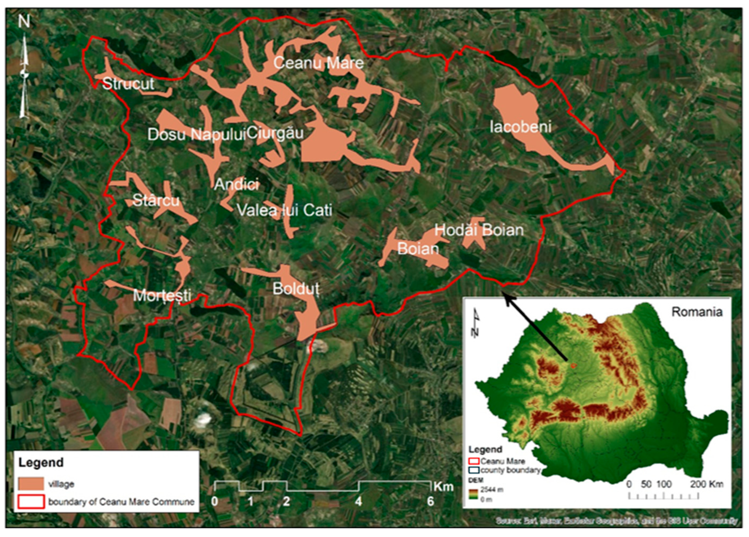
Ceanu Mare commune is located in the southeastern extremity of Cluj County, Romania, at the interface between the Subcarpathian hilly area and the Transylvanian Plain (46°37′50″ N–46°41′00″ N latitude, 23°56′45″ E–24°02′00″ E longitude) (
Figure 1). The local relief is dominated by gently rolling hills, with altitudes ranging from 350 to 430 m, intersected by temporary valleys and small watercourses. Land use displays a mixed structure, including agricultural crops, hayfields, pastures, and household gardens scattered throughout the landscape.
According to the 2021 Population and Housing Census, Ceanu Mare commune has a total population of 3333 inhabitants and 1386 households, comprising 13 villages: Ceanu Mare (the administrative center), Andici, Boian, Bolduț, Ciurgău, Dosu Napului, Fânațe, Hodăi-Boian, Iacobeni, Morțești, Stârcu, Strucut, and Valea lui Cati [
21]. In the present research, questionnaires were administered in nine of these villages, selected to ensure balanced representation according to demographic relevance, infrastructure, and geographic characteristics: Ceanu Mare, Boian, Hodăi-Boian, Iacobeni, Bolduț, Fânațe, Ștrucut, Dosu Napului, and Ciurgău.
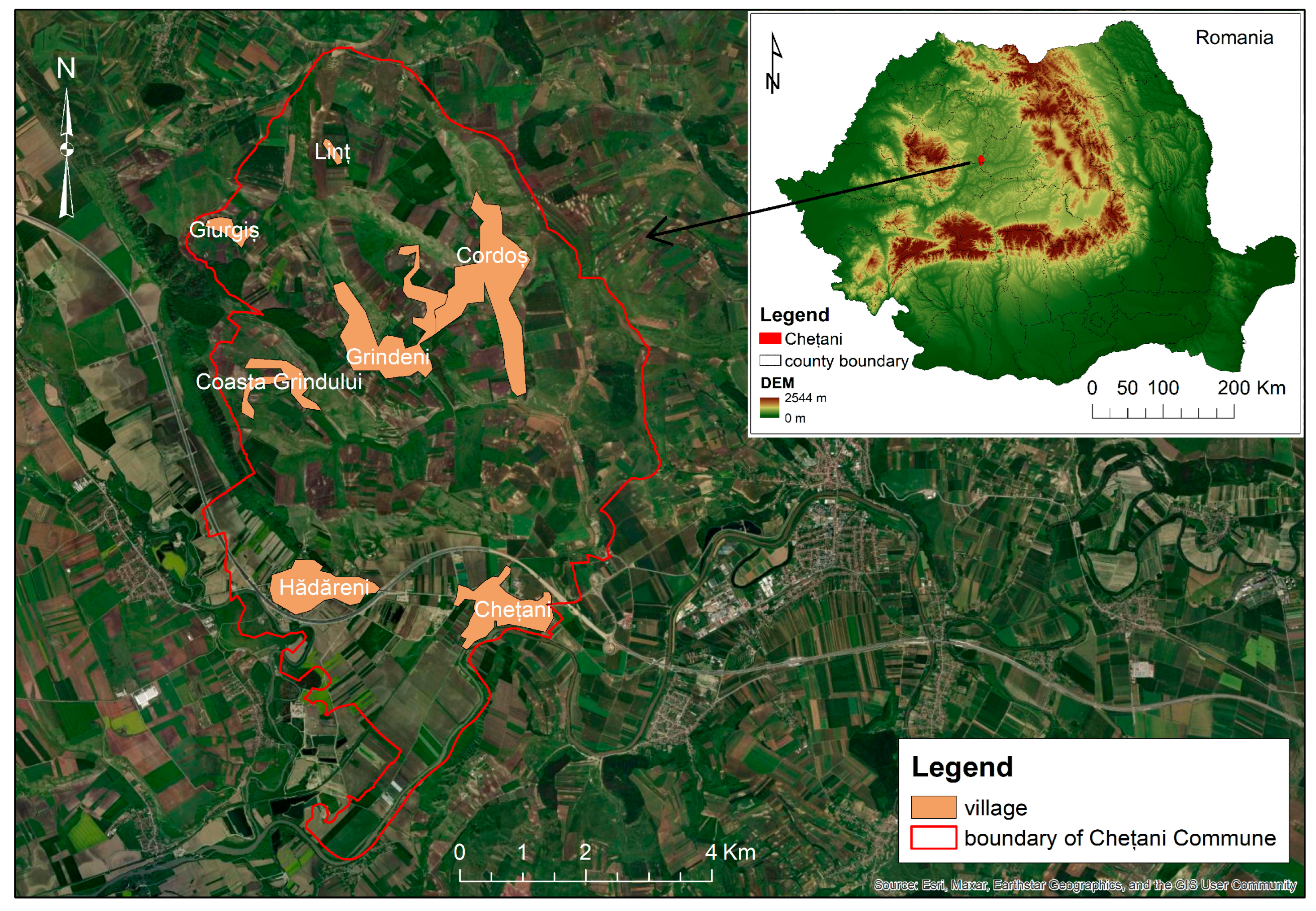
Chețani commune is situated in the southwestern part of Mureș County, Romania, on the left bank of the Mureș River, within the Transylvanian Plain (46°28′00″ N–46°31′00″ N latitude, 23°58′00″ E–24°02′00″ E longitude) (
Figure 2). The local relief is characterized by lowland plains with gentle undulations, at altitudes ranging from 250 to 270 m above sea level and is intersected by the floodplain of the Mureș River and several small tributary valleys. Land use is predominantly arable, with extensive field crops, family gardens, and meadows distributed throughout the territory, and with the presence of partially developed irrigation infrastructure.
According to the 2021 Population and Housing Census, Chețani commune has a total population of 2082 inhabitants and 913 households and comprises seven villages: Chețani (the administrative center), Coasta Grindului, Cordoș, Giurgiș, Grindeni, Hădăreni, and Linț [
21]. For the purposes of the present research, data collection and questionnaires were conducted in the main villages, selected to reflect demographic, infrastructural, and geographic representativeness: Chețani, Hădăreni, and Grindeni.
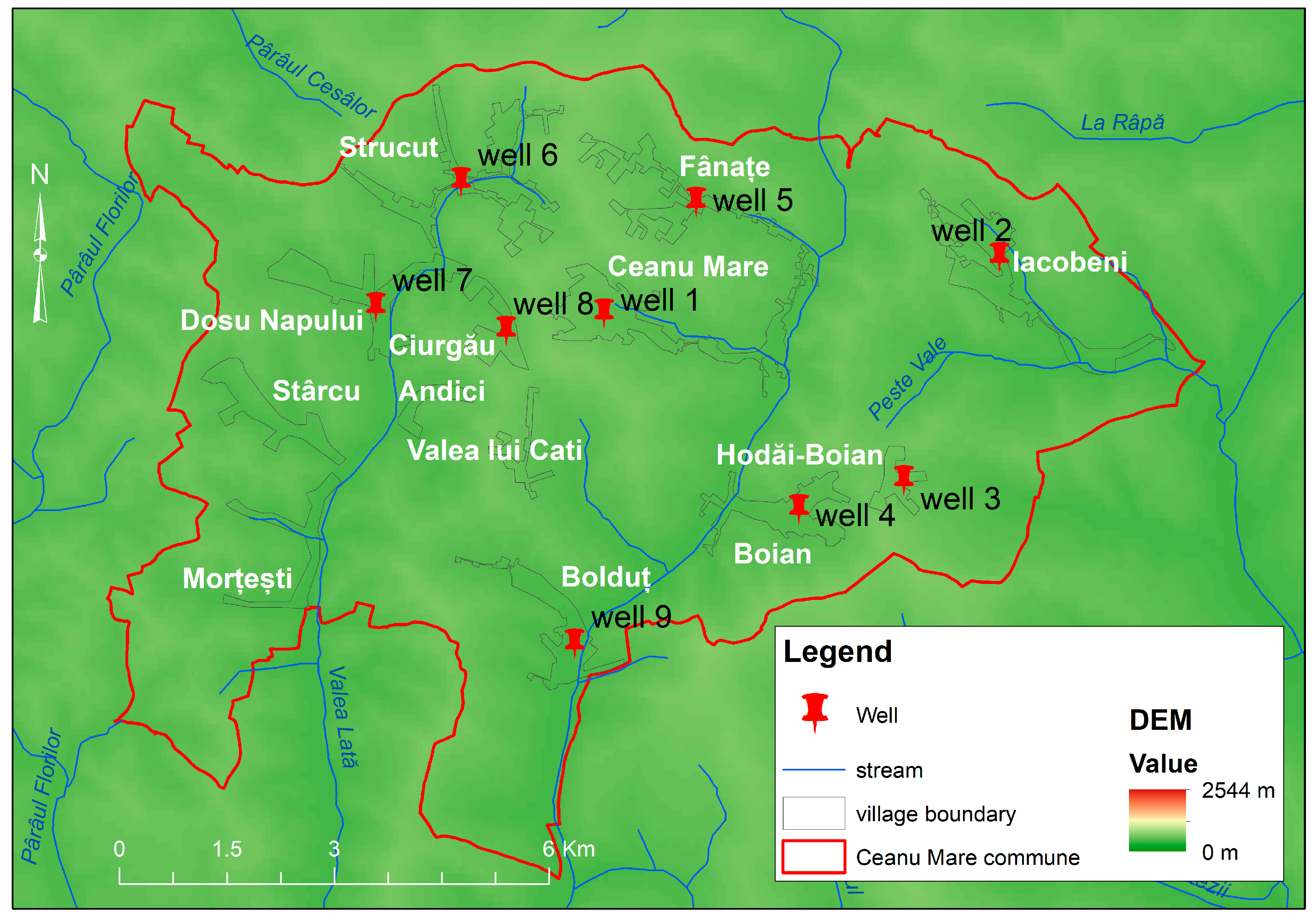
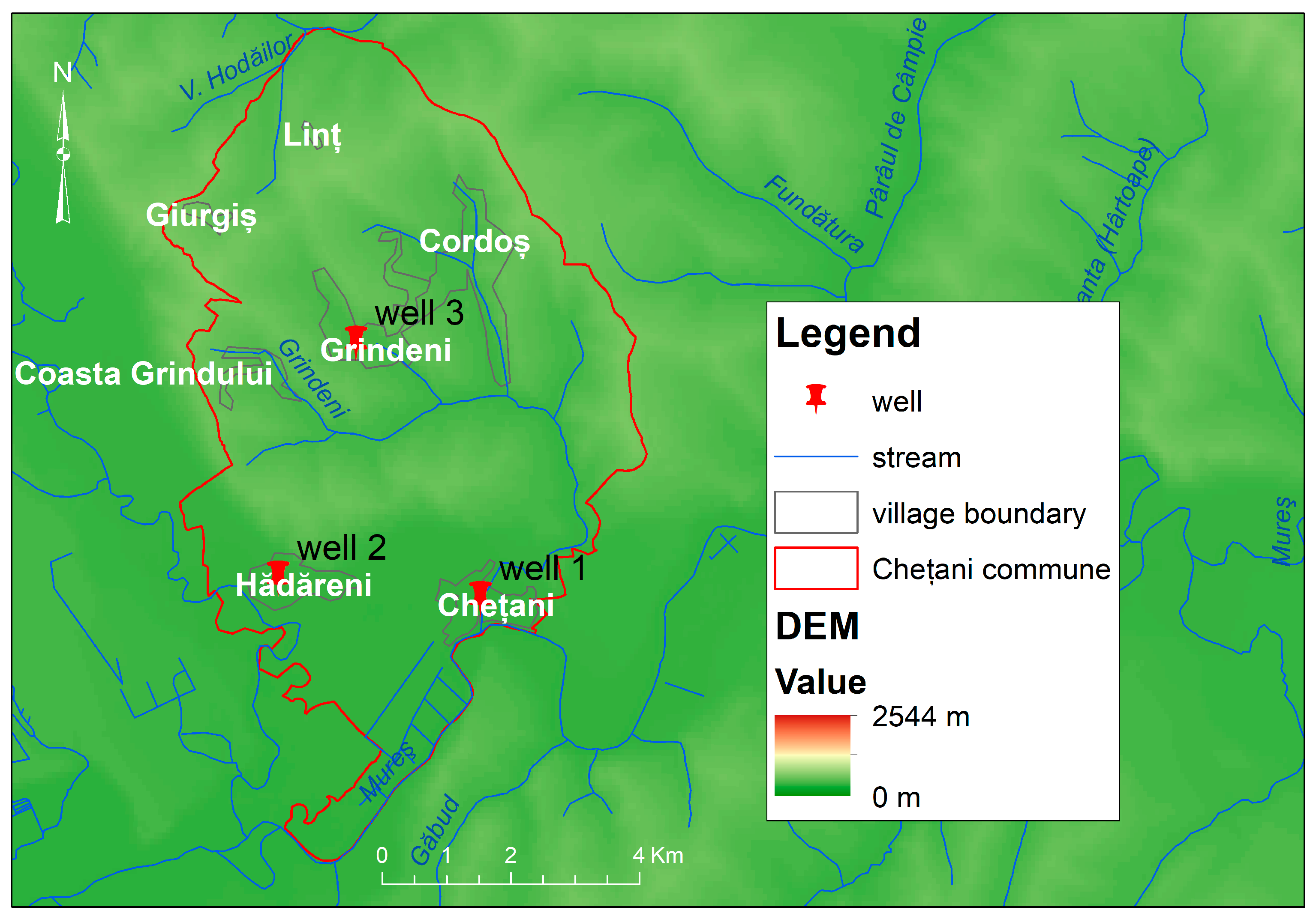
From a hydrogeological perspective, the study area overlies shallow unconfined (phreatic) aquifers developed in Quaternary deluvial–colluvial and alluvial deposits, locally perched above low-permeability Neogene marls and clays on interfluves. In the Mureș floodplain and adjacent terraces (Chețani), Holocene alluvium sustains a laterally continuous phreatic aquifer that is hydraulically connected to the river system.
Figure 3 and
Figure 4 illustrate the hydrogeological context, while
Supplementary File (Table S1) provides details on the well attributes.
The inclusion of these two communes in the analysis enables the evaluation of distinct but methodologically and socio-geographically comparable models of agriculture and natural resource management within the rural context of Transylvania.
2.2. Survey Methodology and Data Processing
A structured household questionnaire was used to collect empirical data on water management, agricultural practices, and environmental perceptions in Ceanu Mare (n = 430 households) and Chețani (n = 184 households) in June 2025. Multiple responses were allowed; percentages were shares of all households (n = 430; n = 184). The instrument was implemented in Google Forms and interviewer-administered at the household level (one response per household). No personal identifiers (names, emails, IP addresses) were collected; participation was voluntary and based on informed consent. Field staff enforced the one-household rule and verified village residence. Data were exported to CSV, stored on an encrypted drive, and analyzed in anonymized form. A short pilot preceded fieldwork to check wording and skip logic; minor layout adjustments were applied.
The questionnaire covered: (i) types of crops cultivated (multiple responses allowed); (ii) irrigated area; (iii) irrigation water sources (multiple responses allowed); (iv) fertilizer type (natural, chemical, combined, none); (v) pesticide-use frequency (annual/near-annual, occasional, none); (vi) procurement channels for agricultural supplies (multiple responses allowed); (vii) perceived pollution (soil and/or water); (viii) awareness of agricultural subsidies; and (ix) basic demographics (village, age, gender). The exact wording of all items and response options is provided in
Supplementary File S1.
Samples were constructed to reflect the demographic and socio-economic structure of each commune, and questionnaires were completed by household representatives. No post-stratification weights were applied. For statistical analysis, only variables directly relevant to the study objectives were retained and harmonized to enable rigorous comparisons between communes. Data processing relied on standard binary (presence/absence) and ordinal (frequency) recoding to produce comparative tables and figures. In particular, binary indicators were computed for perceived environmental pollution (Yes = soil or water pollution reported; No = otherwise) and for awareness of agricultural subsidies (Yes/No).
For multi-response items (e.g., crops, irrigation sources, supply channels), percentages are computed with the number of households as denominator; totals per commune may therefore exceed 100%. Percentages are not area-weighted and do not count plots.
This comparative design enables the identification of both common patterns and meaningful differences in cropping structure, fertilizer/pesticide practices, sourcing of agricultural supplies, irrigation water use, and perceptions of pollution across the two communes, with relevance for similar rural settings in Transylvania [
8,
10,
22].
2.3. Survey, Sampling and Methodology
We examined ecological associations between household fertilization patterns and groundwater indicators. For each commune, we computed the share of households using chemical fertilizers (chemical-only or chemical+natural) and natural-only fertilizers from the survey. Groundwater quality was summarized at the village level as the median and range of NO3−, NO2−, NH4+, and pH (one well per village). Where village-level survey tabulations were available, we also compared village shares of chemical vs. natural-only fertilization with the corresponding well values. This ecological approach does not imply causality but assesses concordance between reported practices and groundwater status.
The selection of wells for water-quality assessment was based on hydrogeological and methodological considerations, aiming to capture representative conditions for each rural settlement. In both Ceanu Mare and Chețani, one well was sampled per village, typically near the village center and close to the household-survey area. Most wells in these rural settings are hand-dug, shallow (~3–15 m), and tap the same superficial aquifer, developed within alluvial or sand–gravel deposits that can extend laterally for hundreds of meters. Within a village, wells tend to intercept a similar hydrostratigraphic horizon, as indicated by comparable static water levels (adjusted for land elevation) and synchronous fluctuations in response to rainfall or drought. Additionally, in karstic/doline-prone areas underlain by limestones, hydraulic connections may occur over longer distances via subsurface galleries or fractures, further supporting the assumption that a single, centrally located well can be representative of the settlement. Therefore, our design (one well per village: 9 in Ceanu Mare, 3 in Chețani) balances spatial representativeness and logistical feasibility, ensuring that sampled water reflects the quality of the aquifer most commonly used by the rural population [
23,
24].
Water was collected immediately after extraction from the selected wells into pre-cleaned containers, following best practices to avoid secondary contamination and in accordance with SR EN ISO 5667-5:2008 [
25]. Field/on-site analyses were performed on site or within ≤2 h of collection.
Analytical methods and instruments: NO
2−: portable photometric analyzer Hanna HI96708 (ferrous-sulfate colorimetry, 575 nm), compliant with SR EN ISO 26777:1993 [
26]; NO
3−: portable photometric analyzer Hanna HI96728 (cadmium reduction, 525 nm); detection range 0.0–30.0 mg/L NO
3−-N with conversion to NO
3− by factor ×4.43; method per SR EN ISO 11905-1:1998 [
27]. Both analyzers were used in accordance with manufacturer protocols [
28], ensuring traceability and analytical validity; NH
4+ (reported as mg/L NH
3-N): in situ colorimetric kits (salicylate/indophenol reaction) with a portable colorimeter, per SR EN ISO 7150-1:2001 (range 0.01–0.8 mg/L NH
3-N) [
29]; pH: portable meter Hanna HI991001 with automatic temperature compensation and two-point calibration; accuracy ±0.02 pH units [
28].
Field colorimetric methods were validated against laboratory standards, with reported accuracies of ±4% for NO
2− [
26] and ±10% for NO
3− [
27], and as specified by manufacturer/method for NH
4+ and pH [
28,
29]. Samples were handled to minimize interference from suspended solids, coloration, or chemical cross-reactivity.
Results were compared with Romanian/EU parametric values for drinking water: 0.50 mg/L NO
2−, 50 mg/L NO
3−, 0.50 mg/L NH
4+, and pH 6.5–9.5 [
30,
31].
2.4. Statistical Analysis
Analyses were descriptive. Survey variables are reported as counts (
n) and percentages (%), using the number of responding households as the denominator; totals may exceed 100% for multi-response items. No post-stratification weights were applied (see
Section 2.2). Village-level groundwater parameters (NO
2−, NO
3−, NH
4+, pH) are summarized by median and range [min–max], and compliance was evaluated against Romanian/EU parametric values (0.50 mg/L NO
2−, 50 mg/L NO
3−, 0.50 mg/L NH
4+, pH 6.5–9.5). Due to the small per-group sample sizes (9 vs. 3 wells), no inferential hypothesis testing was undertaken.
All tabulations and figures were produced in Microsoft Excel (version 365).
3. Results and Discussion
3.1. Distribution of Respondent Households by Village
The sampling was designed to ensure a homogeneous distribution of respondent households covering all relevant villages in both in Ceanu Mare and Chețani communes. This approach enabled balanced comparisons between communities with different agricultural and geographical profiles.
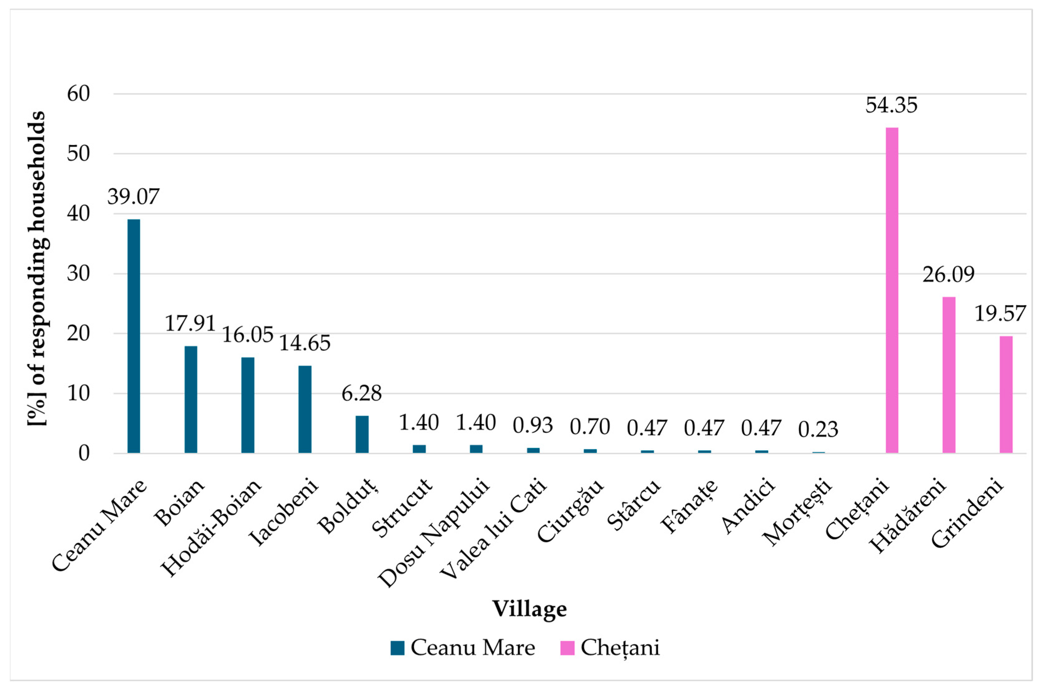
The household distribution in Ceanu Mare is more dispersed, with significant proportions of respondents in several villages, whereas in Chețani, over half of the responses are concentrated in the main village, (
Figure 5). This difference suggests a more centralized rural structure in Chețani and a more evenly distributed population in Ceanu Mare.
3.2. Structure of Main Agricultural Crops
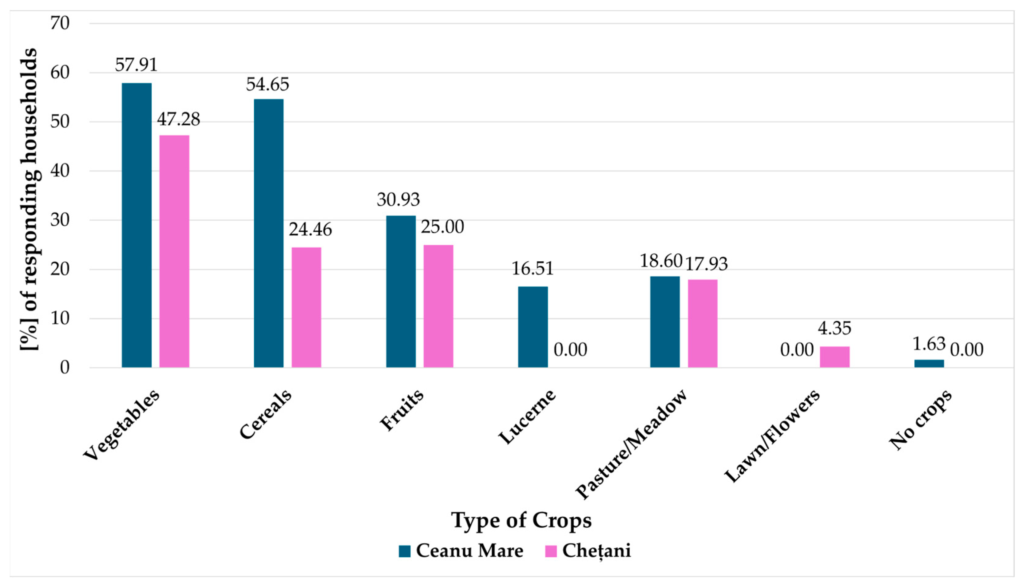
Figure 6 summarizes crop types at the household level (multiple responses allowed). We distinguish annual arable crops (vegetables, cereals), perennials (fruit trees), and forage/grass systems; lucerne (
Medicago sativa L.) is shown separately from pasture/meadow because it is a sown, N-fixing forage crop with distinct management, whereas pasture/meadow refers to permanent or semi-natural grassland.
In Ceanu Mare, larger shares of households report vegetables (57.91%) and cereals (54.65%) than in Chețani (47.28% and 24.46%, respectively). Fruit growing is likewise more frequent in Ceanu Mare (30.93% vs. 25.00%). Lucerne occurs only in Ceanu Mare (16.51% vs. 0.00%). Pasture/meadow is similar (18.60% vs. 17.93%), while lawn/flowers appear only in Chețani (4.35%). No-crops households are rare (1.63% in Ceanu Mare; 0.00% in Chețani). Overall, both communes practice mixed household agriculture, with Ceanu Mare comparatively more engaged in cereals and lucerne.
At the commune scale, Ceanu Mare reports higher household shares for the main crop groups—vegetables 57.91% vs. 47.28% and cereals 54.65% vs. 24.46% in Chețani. Fruit-growing households are likewise more frequent in Ceanu Mare (30.93% vs. 25.00%). Lucerne (Medicago sativa L.) is reported only in Ceanu Mare (16.51%). Pasture/Meadow is comparable (18.60% vs. 17.93%), while Lawn/Flowers appears only in Chețani (4.35%). These differences indicate a broader, more diversified cropping base in Ceanu Mare.
These differences likely reflect household farm structure and production aims: the higher share of cereals and the presence of lucerne (Medicago sativa L.) in Ceanu Mare are consistent with on-farm feed needs and more input-intensive field practices, whereas Chețani shows lower household engagement in cereals and a slightly narrower portfolio, possibly aligned with garden-oriented production and off-farm reliance for staple grains. (Shares are household-based, not area-weighted).
3.3. Cultivated Surface and Irrigation Methods
The extent of cultivated surface and the choice of irrigation methods are key factors influencing agricultural productivity, water use efficiency, and environmental sustainability [
32].
In both communes, most households farm small plots (<500 m2), but Ceanu Mare has a slightly higher share in this category. Chețani stands out for the predominant use of private wells for irrigation (56.5%), while Ceanu Mare relies more on rainwater collection and is marginally more connected to the public water network. A significant proportion of households in both locations do not irrigate at all, reflecting infrastructure gaps and/or low crop intensification.
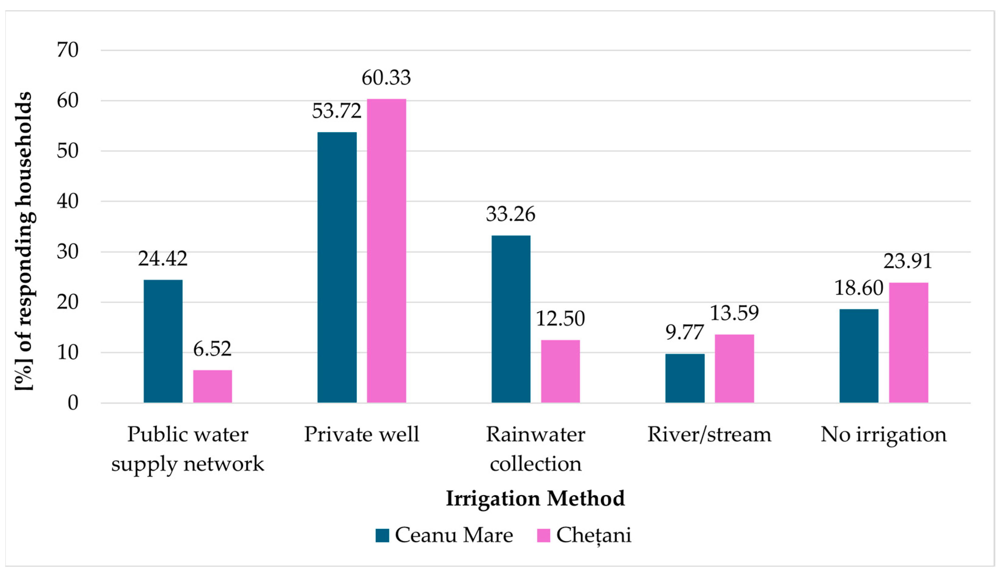
Figure 7 and
Figure 8 summarize household irrigation in Ceanu Mare and Chețani (shares of all households). Small irrigated plots (<500 m
2) are more common in Chețani (46.74%) than in Ceanu Mare (32.56%), while non-irrigating households account for 23.91% in Chețani and 18.60% in Ceanu Mare. In terms of water sources (multiple responses allowed), private wells dominate in both communes (53.72% in Ceanu Mare; 60.33% in Chețani). Rainwater harvesting is notably more prevalent in Ceanu Mare (33.26%) than in Chețani (12.50%). Use of the public water network for irrigation remains limited (24.42% vs. 6.52%), and direct abstraction from rivers/streams is minor in both localities (9.77% and 13.59%, respectively). These patterns highlight predominantly small-scale systems and a strong reliance on self-supplied water, with Ceanu Mare exhibiting a more diversified source portfolio than Chețani.
Small irrigated plots (<500 m
2) are more common in Chețani (46.74%) than in Ceanu Mare (32.56%), while non-irrigating households account for 23.91% in Chețani and 18.60% in Ceanu Mare (
Figure 7). Regarding water sources (multiple responses allowed), private wells dominate in both communes (53.72% in Ceanu Mare; 60.33% in Chețani). Rainwater harvesting is notably more prevalent in Ceanu Mare (33.26%) than in Chețani (12.50%).
Use of the public water network for irrigation remains limited (24.42% vs. 6.52%), and direct abstraction from rivers/streams is minor (9.77% and 13.59%, respectively) (
Figure 8). These patterns highlight predominantly small-scale systems and a strong reliance on self-supplied water, with Ceanu Mare exhibiting a more diversified source portfolio than Chețani.
Comparative interpretation. The dominance of private wells in Chețani aligns with its Mureș floodplain setting and shallow alluvial phreatic aquifer, whereas Ceanu Mare’s greater rainwater harvesting is consistent with hilly interfluves and more dispersed households; limited public-network irrigation and a sizable non-irrigating share reflect infrastructure constraints and small plot sizes in both communes.
3.4. Use of Fertilizers and Pesticides
Fertilizers and pesticides play a critical role in modern agriculture by enhancing crop productivity and ensuring food security. Mineral fertilizers, supply essential nutrients that support plant growth and improve yields. Pesticides are used to manage pests, diseases, and weeds, thereby reducing crop losses and maintaining the quality of agricultural output [
33,
34]. However they can also have negative impacts, particularly on the environment. Excessive or improper use of fertilizers can lead to water pollution, such as eutrophication leading to harmful algal blooms and oxygen depletion. This degrades aquatic ecosystems and affects water quality. Additionally, fertilizers can contaminate groundwater with nitrates, posing health risks to humans and animals. Over time, heavy fertilizer use can also degrade soil health, reducing its ability to retain water and nutrients [
35].
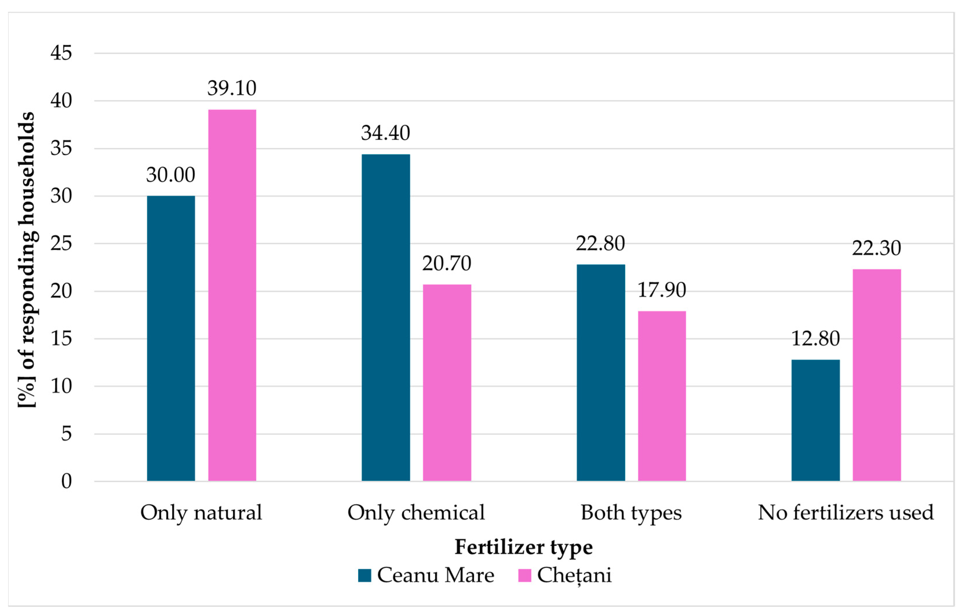
Figure 9 illustrates fertilizer use, highlighting distinct agro-environmental strategies in the two communities. Chețani shows a stronger orientation toward organic fertilization, with 39.10% of households using only natural fertilizers (vs. 30.00% in Ceanu Mare). Conversely, chemical inputs—either alone or combined with natural sources—are more prevalent in Ceanu Mare (57.20% vs. 38.60%), indicating a more input-intensive approach. The share of non-users is higher in Chețani (22.30%) than in Ceanu Mare (12.80%).
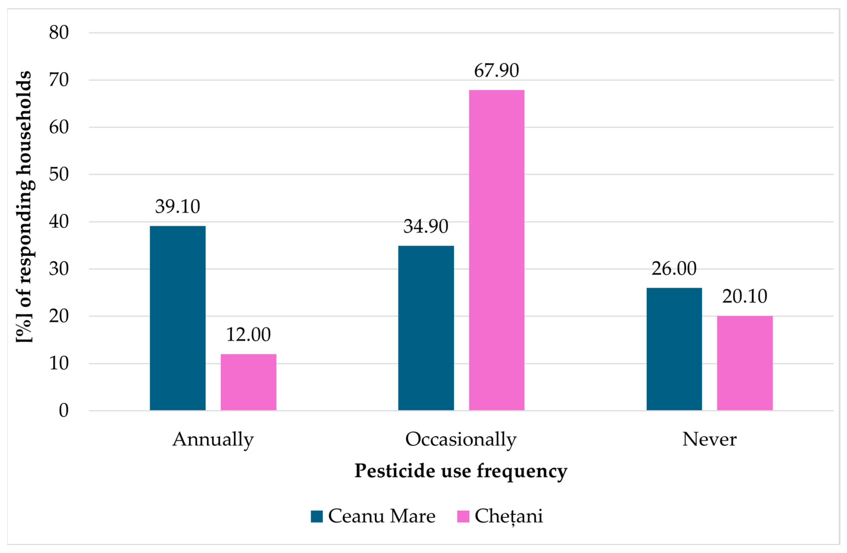
Annual pesticide application is higher in Ceanu Mare (39.10%) than in Chețani (12.00%), whereas occasional use is more widespread in Chețani (67.90% vs. 34.90%). The share of non-users is modestly higher in Ceanu Mare (26.00%) than in Chețani (20.10%) (
Figure 10). From an environmental health perspective, frequent use of pesticides can increase the risk of leaching into groundwater and accumulation in soil, while also affecting its microbial activity [
22,
36].
3.5. Inputs, Agricultural Information, and Perceptions of Pollution and Subsidies
Procurement channels for agricultural supplies differ between the two communes (
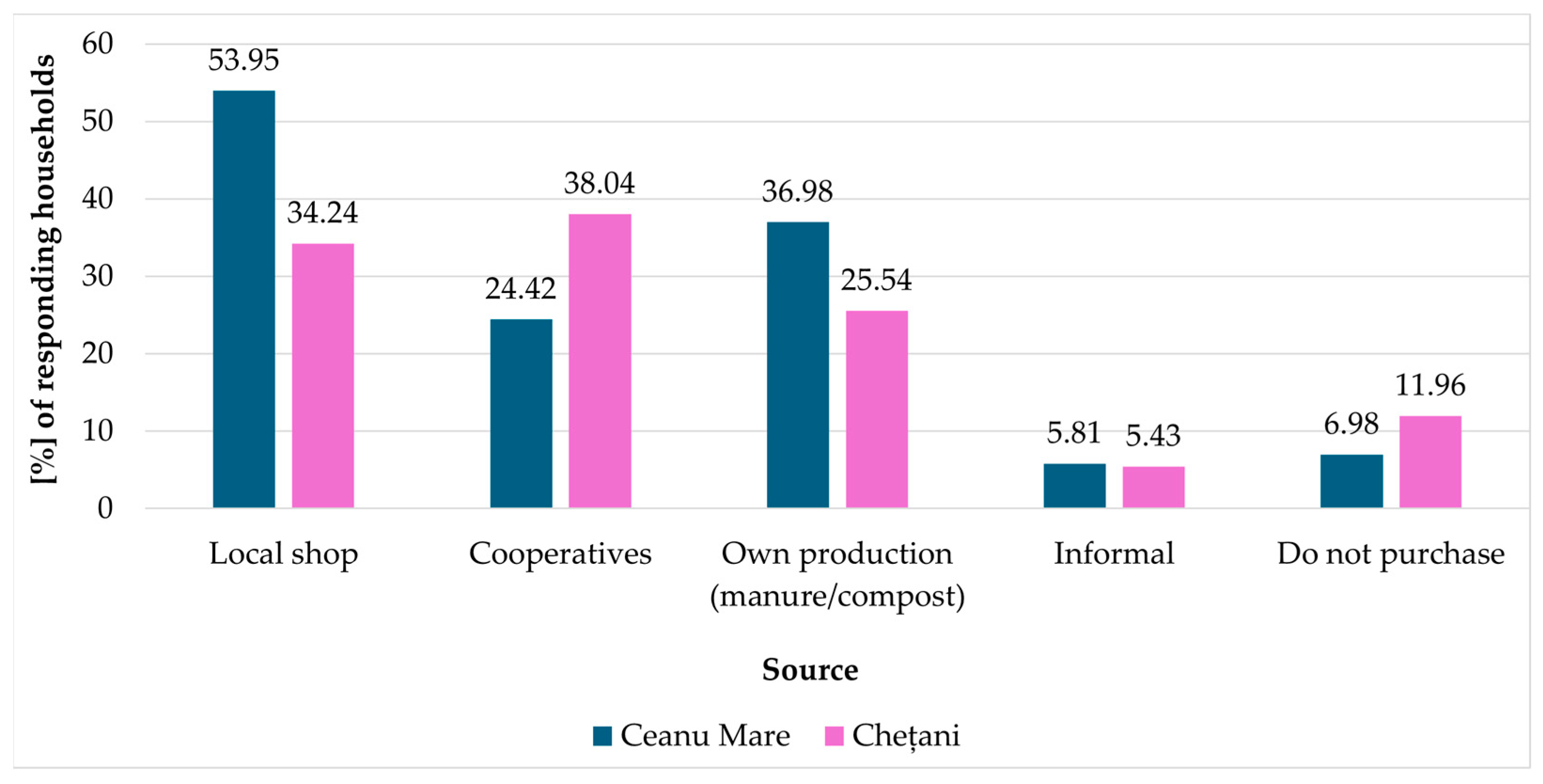
Figure 11). While local shops are the main channel in both places, they are used much more in Ceanu Mare (53.95%) than in Chețani (34.24%). Cooperative purchasing is higher in Chețani (38.04%) than in Ceanu Mare (24.42%), whereas on-farm production of supplies (manure/compost) is more frequent in Ceanu Mare (36.98% vs. 25.54%). Informal channels remain marginal, and the share that does not purchase supplies is larger in Chețani (11.96%) than in Ceanu Mare (6.98%), indicating different balances between market procurement and self-provisioning.
Households in Ceanu Mare are more likely to perceive pollution issues and to be aware of agricultural subsidies compared to those in Chețani, as is indicated in
Figure 12. This may reflect higher environmental awareness, better access to information, or distinct institutional contexts.
Perceived pollution and awareness also diverge. Perceived soil or water pollution is reported by 60.20% of households in Ceanu Mare vs. 17.40% in Chețani; awareness of agricultural subsidies is 34.00% in Ceanu Mare vs. 4.90% in Chețani, pointing to higher environmental concern and information uptake in Ceanu Mare.
As used here, perceived pollution is a binary indicator (Yes = soil or water pollution reported), and awareness of subsidies is a binary indicator (Yes = respondent aware of subsidy programs).
Predominance of local shops in both communes suggests short input chains typical of rural markets; the higher own-production share in Chețani is coherent with self-provisioning (e.g., manure, saved seed), while cooperative purchases in Ceanu Mare indicate more organized input acquisition—both patterns resonating with the crop structure.
3.6. Chemical Profile and Environmental Impact of Agrochemicals
Agrochemical practices differ between the two communes (
Figure 9 and
Figure 10): natural-only fertilizers are more frequent in Chețani (39.1%) than in Ceanu Mare (30.0%), whereas chemical inputs—alone or combined with natural sources—prevail in Ceanu Mare (57.2% vs. 38.6%). Pesticide use also differs: annual/near-annual application is higher in Ceanu Mare (39.1%) than in Chețani (12.0%), while occasional use is more widespread in Chețani (67.9% vs. 34.9%).
Mineral fertilizers most commonly reported include ammonium nitrate (NH
4NO
3), urea [CO(NH
2)
2], superphosphate [Ca(H
2PO
4)
2], and potassium chloride (KCl), typically applied alongside organic sources. After soil application, urea is hydrolyzed by urease to ammonium and then nitrified to nitrate—a mobile, leachable ion [
5,
37] following the reactions:
Natural fertilizers commonly include organic manure, compost, green manure (such as cover crops), and animal waste, which originate from livestock farms, crop residues, or dedicated cultivation of nitrogen-fixing plants [
38].
This pathway aligns with our finding of elevated yet sub-limit NO
3−. Superphosphate contributes mainly to runoff-driven eutrophication rather than leaching, while excess Cl
− from KCl can promote soil salinization and affect water quality [
39]; these parameters were not measured here, so we discuss them as risk framing only.
Respondents most often cited glyphosate (C
3H
8NO
5P), 2,4-D (C
8H
6Cl
2O
3), mancozeb (C
4H
6MnN
2S
4Zn) and copper sulfate (CuSO
4·5H
2O). Glyphosate degrades to AMPA, a persistent metabolite frequently detected in waters [
22]; 2,4-D is leachable depending on soil and moisture conditions [
36]; mancozeb forms ethylene thiourea (ETU); and repeated copper-based applications can accumulate Cu in soils and perturb microbial communities [
37]. Although we did not assay pesticide residues, the combination of annual applications (more common in Ceanu Mare) and shallow household wells increases leaching risk, supporting stewardship measures (dose calibration, timing relative to rainfall, vegetated buffer strips, and integrated pest management).
In these shallow phreatic settings, the dominant risks are nitrate leaching, runoff-driven phosphate eutrophication, and persistence/leaching of pesticide residues (notably glyphosate/AMPA and 2,4-D/ETU) frequently reported in Romanian and European rural groundwater [
4,
22,
23,
31]. The observed chemistry—NO
3− elevated yet below 50 mg/L and NO
2− near the 0.50 mg/L threshold with occasional exceedances in Ceanu Mare, while NH
4+ and pH remain within standards—is consistent with the combination of reported fertilizer/pesticide practices and the aquifer context. These findings support integrated nutrient and pesticide stewardship (dose calibration, rainfall-aware timing, vegetated buffers, IPM) and routine monitoring of household wells [
4,
39].
3.7. Household Well Water Quality
The results of groundwater analyses, NO
2−, NO
3−, NH
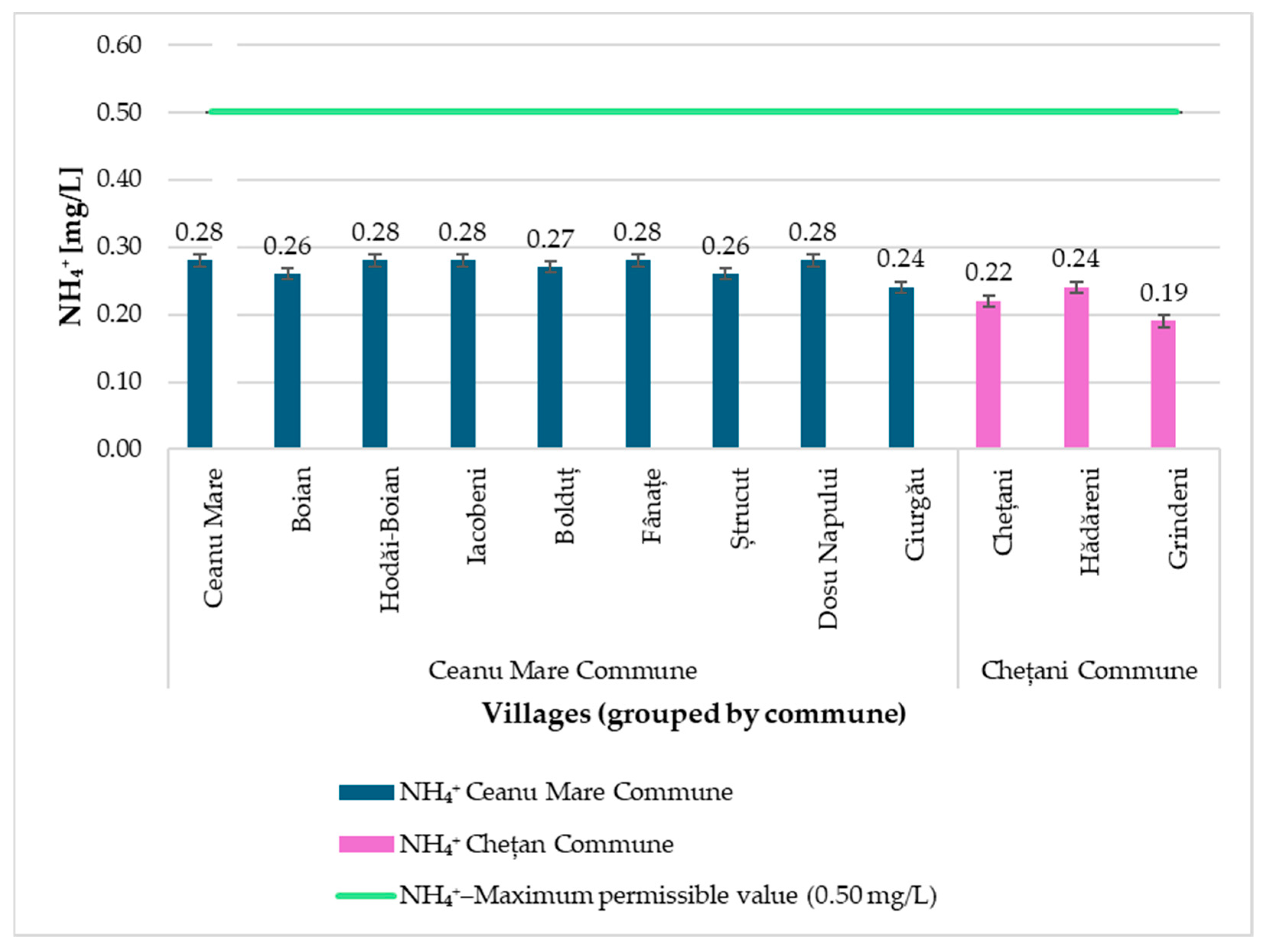
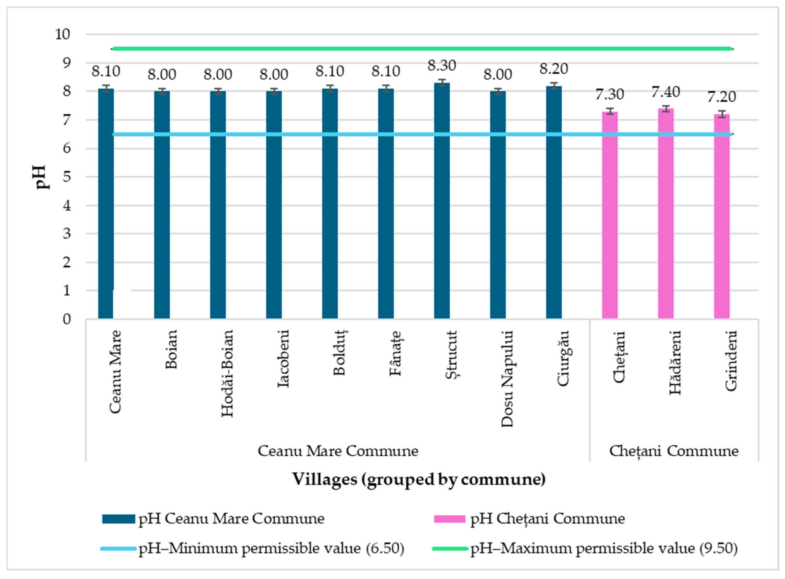
4+ and pH in household wells from Ceanu Mare and Chețani communes are presented in
Figure 13,
Figure 14,
Figure 15 and
Figure 16.
These results presented in
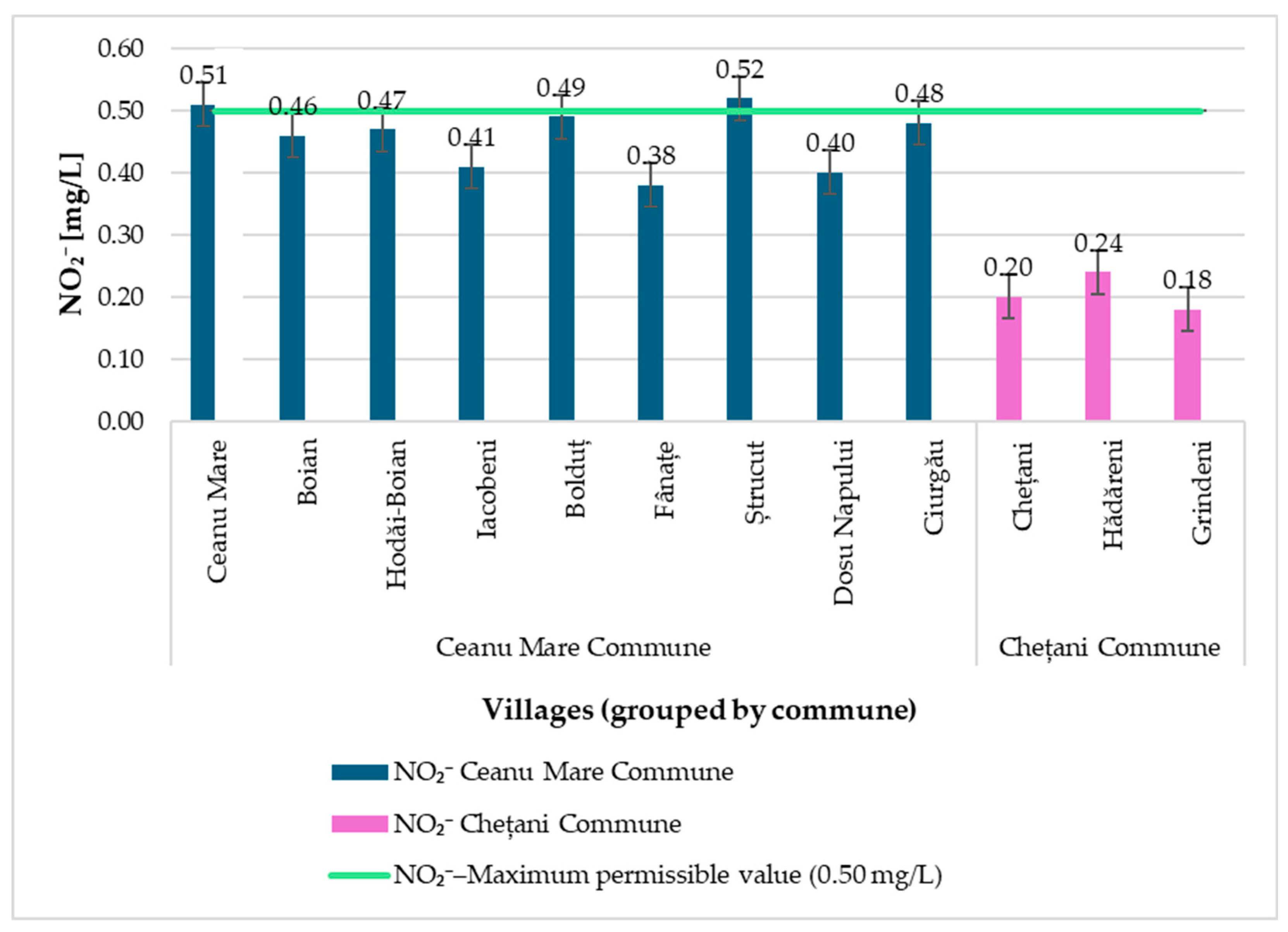
Figure 13 demonstrates that several wells in Ceanu Mare (Ceanu Mare village, Ștrucut, and to a lesser degree Boldut and Ciurgău) approach or exceed the legal limit for NO
2−, indicating recent or ongoing contamination with reduced nitrogen species. In contrast, all wells in Chețani remain well below the critical threshold.
All samples are well within permissible limits, but the higher values observed in Ceanu Mare (up to 0.28 mg/L NH4+) may signal organic input or anthropogenic pressure. In Chețani, NH4+ concentrations are lower, consistent with less intensive land use or more effective sanitation.
All wells exhibit slightly alkaline pH values, with Ceanu Mare samples trending higher (8.0–8.3), likely reflecting carbonate-rich local geology or agricultural amendments. Chețani samples display lower, yet still safe, pH values (
Figure 16).
Figure 13,
Figure 14,
Figure 15 and
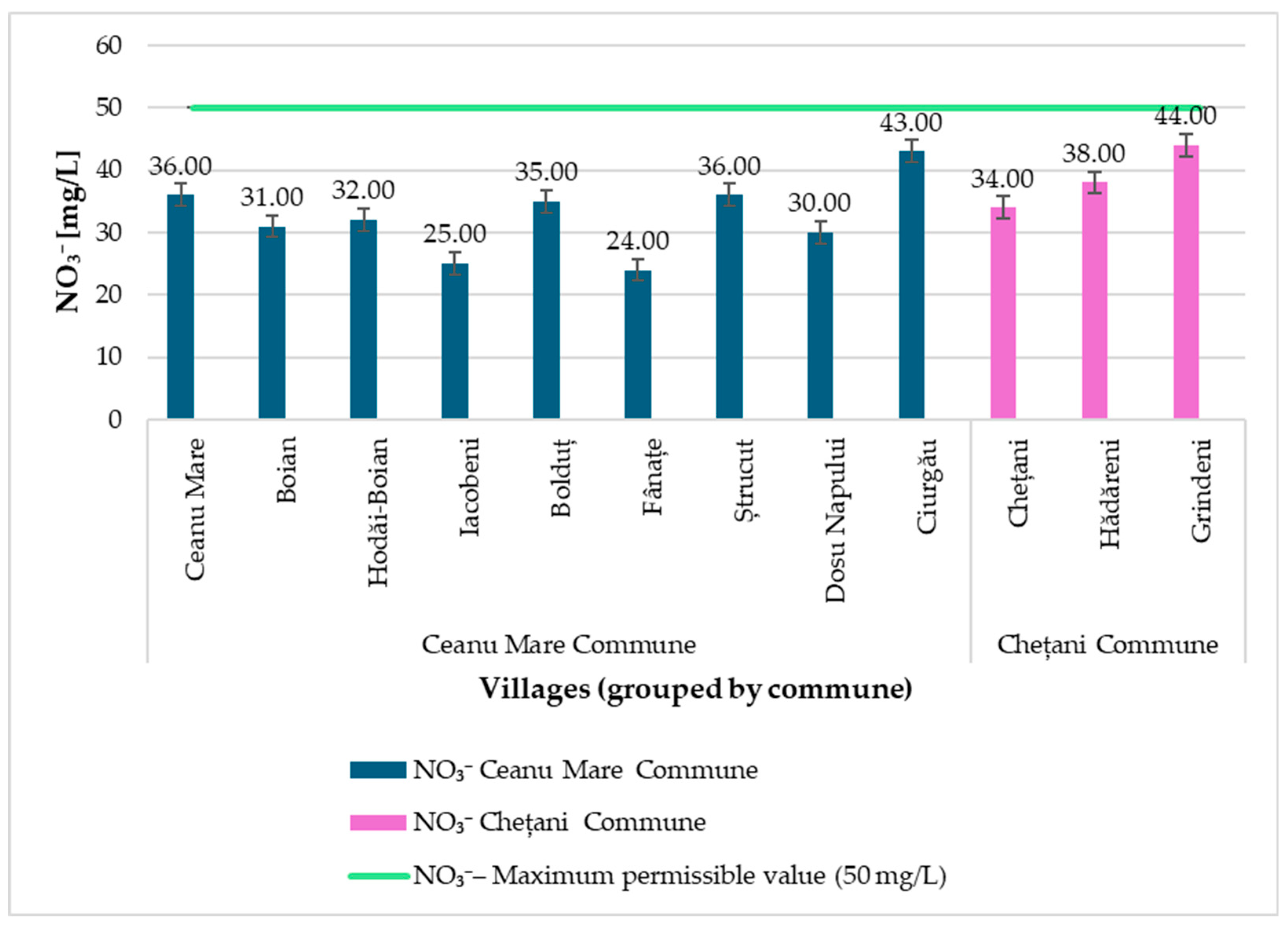
Figure 16 show a spatially heterogeneous groundwater pattern. In Ceanu Mare, several village wells (Ceanu Mare, Ștrucut, and to a lesser degree Bolduț and Ciurgău) approach or exceed the nitrite threshold (0.50 mg/L), whereas all wells in Chețani remain well below this level. Nitrate is elevated yet sub-limit (~43–44 mg/L) in both communes (Ciurgău and Grindeni), ammonium remains within limits (up to 0.28 mg/L in Ceanu Mare), and pH is slightly alkaline. These findings underline the vulnerability of shallow household wells to agricultural and sanitation pressures and the need for regular monitoring and targeted interventions; proximity to the legal limits for nitrate (50 mg/L) and nitrite (0.50 mg/L) [
30,
31] signals exposure risks (e.g., infant methemoglobinemia; nitrosamine-related effects) [
40].
Since the values determined for NO
3− are at the upper limit of the accepted range, but remain below the maximum permissible threshold, and NO
2− concentrations occasionally approach or exceed the parametric value, soil remediation measures are not necessary at this stage. However, it is recommended to implement simple and effective interventions aimed at reducing nutrient input and limiting population exposure. At the household level, fertilizer management based on the 4R Nutrient Stewardship principle (Right source, Right rate, Right time, Right place) [
41]. Maintaining 5–10 m vegetated strips around wells and ditches [
41,
42], along with the implementation of buffer strips or small constructed wetlands on drainage lines [
43], ensures effective mitigation at the landscape level, and in situations with higher concentrations, wood chip denitrifying bioreactors can be used [
44]. At the same time, the sanitary protection of wells, by upgrading or relocating faulty latrines and septic tanks and respecting safety distances (≥30 m, hydraulically downstream of wells), is an essential measure to prevent contamination [
45]. For domestic consumption, water treatment by reverse osmosis or anion exchange is effective, while boiling is inadequate and may even increase nitrate concentration through evaporation [
40,
46]. These integrated measures, combined with continuous monitoring and education of the population on the responsible use of fertilizers, can contribute to maintaining water quality within safe limits and reducing risks to public health.
3.8. Mitigation Options and Future Actions
Based on our results—nitrate below the 50 mg/L parametric value and nitrite near or slightly above 0.50 mg/L in a few villages—there is scope for targeted, evidence-based measures to reduce diffuse inputs to shallow household wells.
- (i)
Improve nutrient stewardship (4R). Align fertilizer source–rate–time–place with crop demand and avoid applications before high-runoff events; these practices increase nutrient use efficiency and lower losses to water while maintaining yields [
33,
38,
41].
- (ii)
Integrated pest management (IPM). Emphasize non-chemical controls and judicious pesticide use to reduce inputs that can reach drinking water; reviews document pesticide occurrence and pathways into potable supplies [
22,
42].
- (iii)
Manure handling and timing. Ensure covered storage and field application under suitable soil moisture conditions; prioritize incorporation to limit overland transport and leaching [
33,
38].
- (iv)
Edge-of-field/landscape practices. Use constructed wetlands and woodchip bioreactors on drainage pathways to intercept dissolved nitrogen before it reaches receiving waters or shallow aquifers [
43,
44].
- (v)
Wellhead sanitary protection. Retrofit sanitary aprons, maintain intact casings and tight covers, and ensure adequate separation from latrines and manure piles; follow practical well-owner guidance and health-based recommendations [
40,
45].
- (vi)
Household point-of-use (where needed). For individual households, certified reverse osmosis devices can provide an additional barrier to nitrate/nitrite when source control is being implemented [
46].
- (vii)
Monitoring and communication. Maintain periodic testing of NO
2−/NO
3− (and microbiological indicators) and report results against the applicable parametric/guideline values (0.50 mg/L for nitrite; 50 mg/L for nitrate) from European and WHO frameworks [
30,
40].
- (viii)
Local planning context. These measures align with European sustainability guidance on agriculture–water interactions and can be prioritized with local data already reported for the study area [
15,
19].
4. Conclusions
This study highlights significant differences in agricultural practices and environmental risk awareness between the communes of Ceanu Mare and Chețani, as well as their impact on groundwater quality. Ceanu Mare stands out for its stronger focus on vegetable cultivation, use of modern technologies, and higher perception of environmental risks, whereas Chețani is characterized by more extensive cereal production and greater reliance on organic fertilizers and private wells. Chemical analysis of household well water revealed nitrates were below 50 mg/L in all wells; nitrites were within or slightly above 0.50 mg/L in a few Ceanu Mare villages, indicating the vulnerability of these sources to agricultural contamination. In contrast, ammonium concentrations and pH values remained within normal ranges, reflecting both geological and anthropogenic influences. The results emphasize the clear connection between agricultural practices, soil management, and water quality, underlining the need for integrated strategies for fertilizer and pesticide management, continuous water monitoring, and community education. Furthermore, locally adapted policy interventions and effective information dissemination can help reduce environmental vulnerabilities and enhance the resilience of rural communities in Transylvania and across Central and Eastern Europe.
