Article

Automatic Detection System for Rainfall-Induced Shallow Landslides in Southeastern China Using Deep Learning and Unmanned Aerial Vehicle Imagery

1
Geological Environment Monitoring Institute of Jiangxi Geological Survey and Exploration Institute, Nanchang 330006, China
2
Nanchang Wanli Geological Disaster Field Scientific Observation and Research Station, Nanchang 330006, China
3
School of Engineering and Technology, China University of Geosciences (Beijing), Beijing 100083, China
*
Author to whom correspondence should be addressed.
Water 2025, 17(15), 2349; https://doi.org/10.3390/w17152349
Submission received: 29 June 2025 / Revised: 19 July 2025 / Accepted: 20 July 2025 / Published: 7 August 2025

Abstract

In the southeast of China, seasonal rainfall intensity is high, the distribution of mountains and hills is extensive, and many small-scale, shallow landslides frequently occur after consecutive seasons of heavy rainfall. High-precision automated identification systems can quickly pinpoint the scope of the disaster and help with important decisions like evacuating people, managing engineering, and assessing damage. Many people have designed systems for detecting such shallow landslides, but few have designed systems that combine high resolution, high automation, and real-time capability of landslide identification. Taking accuracy, automation, and real-time capability into account, we designed an automatic rainfall-induced shallow landslide detection system based on deep learning and Unmanned Aerial Vehicle (UAV) images. The system uses UAVs to capture high-resolution imagery, the U-Net (a U-shaped convolutional neural network) to combine multi-scale features, an adaptive edge enhancement loss function to improve landslide boundary identification, and the development of the “UAV Cruise Geological Hazard AI Identification System” software with an automated processing chain. The system integrates UAV-specific preprocessing and achieves a processing speed of 30 s per square kilometer. It was validated in Wanli District, Nanchang City, Jiangxi Province. The results show a Mean Intersection over Union (MIoU) of 90.7% and a Pixel Accuracy of 92.3%. Compared with traditional methods, the system significantly improves the accuracy of landslide detection.

1. Introduction

1.1. Background of the Study

Rainfall-induced landslides are common geological disasters that pose serious threats to the safety of human life and property and the ecological environment. In the hilly and mountainous areas of Southeast China, the terrain is more undulating, the geological structure is complex, and the stability of the geotechnical mass is poor. When there is heavy rain, water quickly seeps into the ground. These processes increase the geotechnical mass weight, reduce shear strength, and elevate pore water pressure. These factors collectively reduce slope stability and greatly increase the chance of rainfall-induced landslides [1,2]. In the study area, intense seasonal rainfall acts as the dominant trigger for shallow landslides. The subtropical monsoon climate delivers concentrated heavy precipitation, with maximum daily rainfall exceeding 228 mm. This high-intensity rainfall rapidly infiltrates the deep, weathered granite layers, saturating loose sandy clay and gravelly soils. The resultant reduction in effective stress and shear strength destabilizes slopes, particularly on steep hillsides where drainage is inefficient. Historically, over 80% of landslides in the region correlate with prolonged or extreme rainfall events, underscoring its primary role in slope failure mechanisms.
The occurrence of shallow landslides in the study area is closely associated with multiple factors. Their hazards primarily manifest as damage to settlements, roads, and other infrastructure, posing a serious threat to residents’ lives and property. According to research reports, the study area contains a significant number of landslide hazard sites: historically, 244 geological hazard sites have been recorded, and there are currently 468 potential geological hazard sites. Among these, landslides and potential landslide sites constitute a substantial proportion, numbering 166 and 85 sites, respectively, accounting for 35.47% and 18.16% of the total hazard sites. As a representative region of the hilly terrain in South China, Wanli District exhibits a significantly higher landslide density than the national average. The district contains 468 potential landslide sites (166 landslides and 171 collapse hazards), yielding a disaster density of 1.89 sites/km2, which far exceeds the average for hilly regions in China (0.3–0.8 sites/km2, Ministry of Natural Resources, 2020). Globally, Wanli’s annual precipitation (1559.8 mm) aligns with high-incidence landslide regions (e.g., Kyushu, Japan, or the Apennines, Italy), but its thick granite weathering crust predisposes it to frequent small-to-medium scale (<100,000 m3) landslides, contrasting with lower-frequency events in temperate zones (e.g., the Appalachian Mountains, USA).
The spatial distribution of landslide hazards is uneven, primarily concentrated in low mountainous to hilly regions. Their distribution exhibits a strong correlation with village locations and transportation routes, displaying distinct patchy and linear patterns. The predominant landslide type is soil landslides, composed mostly of loose gravelly soil, sandy clay, and sandy clay containing gravel and cobbles. The thickness of the sliding mass generally ranges from 1 to 5 m and has a relatively loose structure.
The primary triggering factors for landslides are rainfall and human engineering activities. These activities disrupt the stress equilibrium of slopes, leading to a reduction in slope stability. In plan view, landslides are predominantly tongue-shaped or semi-circular, while in profile, they are primarily arcuate, accounting for 78.95% of the observed cases. Landslides exhibit a high degree of suddenness, typically lacking obvious prior deformation stages. They frequently occur abruptly under the influence of rainfall, resulting in a high level of risk.
The accurate and timely detection of rainfall-induced landslides plays a key role in disaster prevention and mitigation. Small landslides can be fixed with engineering solutions like stabilizing the slope and building retaining walls. However, for big landslides, lowering the slope on a large scale and implementing load shedding, drainage, and channelization may be needed. Accurate landslide identification is essential to rationally plan resources, formulate scientific and effective management plans, and minimize disaster losses. This study is devoted to the development of advanced landslide identification software to improve the efficiency and accuracy of rainfall-induced landslide identification.

1.2. Synthesis of Work Related to Rainfall Landslide Detection

Over the past few decades, as geohazard research has grown and technology has kept getting better, different methods have been used to find rainfall-induced landslides. Each of these methods has its own use and set of circumstances.
In the domain of UAV-based landslide detection using deep learning, Catani [3] proposed a deep learning framework for identifying landslides from non-nadir and crowdsourced optical images. Comparative analyses with traditional CNN models demonstrated that their approach achieved an average accuracy of 87–90%, leveraging transfer learning to adapt pre-trained models to UAV-specific data. This method facilitated autonomous drone guidance and post-disaster verification, though performance was limited in steep terrain. Subsequently, Yang et al. [4] advanced the methodology by integrating the Single Shot MultiBox Detector with transfer learning, achieving an 8.7% improvement in recognition accuracy over baseline models. Their framework demonstrated robustness in adapting to satellite imagery, attaining 64.7% precision on remote sensing data. Kariminejad et al. [5] comprehensively evaluated six deep learning algorithms (including ResU-Net and MA-Net) for landslide and sinkhole detection in semi-arid environments. The ResU-Net model achieved an F1-score of 0.95 for landslide detection, while MA-Net excelled at sinkhole identification, highlighting the importance of algorithm selection for heterogeneous landscapes. Zhang & Wang (2024) [6] proposed a five-task framework integrating classification, detection, segmentation, and temporal modeling for landslide monitoring. Their experiments demonstrated strong generalization across diverse datasets, though challenges persisted in small-sample training and 3D temporal modeling. Meanwhile, Sun et al. [7] reviewed multi-sensor fusion (RGB, LiDAR, multispectral) and M3C2 algorithms for 3D change detection, emphasizing automation in landslide monitoring. Their work achieved sub-centimeter-level horizontal precision (4–7 cm) and validated the superiority of M3C2 over traditional DEM differencing methods. It should be noted that the selection of deep learning models must be context-dependent. For example, Ghorbanzadeh et al. [8] demonstrated that CNN architectures surpass traditional machine learning methods in processing high-resolution remote sensing imagery; however, particular attention should be paid to the impact of input window dimensions and layer configuration on predictive accuracy. Furthermore, the Attention–YOLOv3 framework developed by Fu et al. [9] effectively characterizes slow-moving landslide features through its attention mechanism, while the GC-GRU-N network proposed by Liu et al. [10] achieves marked improvement in forecasting precision by modeling spatial dependencies via graph neural networks. Notwithstanding the capacity of transfer learning to mitigate data scarcity challenges, model generalizability remains constrained by the diversity and quality of training data. Future research should prioritize exploring compact architecture design, multimodal data fusion, and temporal dynamics modeling strategies to address landslide detection demands under complex terrain and extreme meteorological conditions [11]. Table 1 systematically compares the state-of-the-art deep learning models deployed in UAV-based landslide detection over the past decades, delineating their core architectural capabilities and operational constraints within geohazard monitoring contexts. Furthermore, the versatility of deep learning-based image segmentation is evidenced by its successful application in related monitoring tasks beyond geohazards, such as the visual inspection of critical infrastructure like power transmission lines [12]. This highlights the adaptability and potential for cross-sectoral technology transfer of such approaches.
Wide-area remote sensing is a satellite-based remote sensing technology that has been widely used in the field of landslide detection by virtue of its large-area coverage and image acquisition capability. For instance, the Landsat series of satellites has a multispectral imager that can collect image data in different wavelength bands. This lets researchers look at satellite images from different times to see how vegetation cover, topography, and soil moisture change over time. By looking at Landsat images from a long period of time, changes in the vegetation cover before and after landslides can be seen in mountainous areas that are prone to them, and signs of landslides can be inferred. This is because after landslides occur, the original vegetation is destroyed, and the vegetation cover is significantly reduced. In addition, by processing and analyzing topographic data, it is possible to identify small changes in the terrain that may be associated with potential areas of landslide occurrence [13,14]. However, the spatial resolution of satellite images is usually low, and the multispectral image resolution of satellites such as Landsat 8 is only up to 30 m, which makes it difficult to identify small-scale, shallow landslides, especially in complex terrain, where high vegetation cover or terrain occlusion can further increase the difficulty of identification [15].
Airborne Light Detection and Ranging (LiDAR) technology is also important in the field of landslide detection. The technology utilizes laser beams to scan the ground surface; they can penetrate the vegetation and obtain highly accurate surface elevation data. In densely vegetated areas, using traditional optical remote sensing it is difficult to obtain accurate surface information due to the influence of vegetation cover, while airborne LiDAR technology shows unique advantages. For example, in some forested mountainous areas in North America, researchers have successfully drawn detailed topographic maps of landslide areas with the help of airborne LiDAR technology, identifying potential landslide areas that are difficult to detect by other methods [16]. The boundaries and changes in slope of the landslide body can be clearly seen by looking at the Digital Elevation Model (DEM) made from the LiDAR data. This is important data for assessing and preventing landslides. However, the high cost of airborne LiDAR technology, the relatively limited range of data acquisition, and the need for specialized equipment and operators have, to a certain extent, limited its wide application [17].
In addition to the remote sensing techniques mentioned above, ground-based monitoring also plays an important role in landslide detection. Instruments such as inclinometers and piezometers can monitor the deformation of slopes and soil pore water pressure in real time. Inclinometers are used to monitor the displacement of soil on a slope by measuring the change in inclination at different depths in a borehole and thus determining whether there is a risk of a landslide. Piezometers, on the other hand, are used to measure the water pressure in the soil pore space, and when the pore water pressure increases, it may signal the occurrence of a landslide [18]. A lot of inclinometers and piezometers are in place along some major transportation routes to make a real-time monitoring network that will provide data for making sure traffic is safe. However, the monitoring range of these instruments is limited, and many sensors are required to cover a larger area, which not only is costly but also more complicated for data integration and analysis.
Table 1. Comparison of U-Net, PSP-Net, DeepLabv3+, HRNet, and Swin Trans.
ArchitectureKey FindingsTechnical Limitations
U-NetExcels in edge detection but struggles with long-range dependencies; accuracy drops under high brightness/contrast [19,20]Limited long-range dependency modeling; degrades under high-contrast lighting
PSP-NetSuperior multi-scale context aggregation; produces sharp edges but sensitive to learning-rate tuning [21,22]Fixed pooling levels hinder irregular object segmentation
DeepLabv3+Robust to scale variations; achieves > 95% OA in structured landscapes but suffers from boundary shifts [23,24]Atrous convolution leads to boundary fragmentation
HRNetMaintains high-resolution features; stable in small datasets but computationally intensive [25]High memory footprint for 3D deployment
Swin TransSOTA global context modeling; +3.2 MIoU gains over CNNs but requires extensive pretraining [26]Quadratic self-attention complexity; slow receptive field expansion

1.3. Existing Problems

Although technologies such as wide-area remote sensing, airborne LiDAR, and ground-based monitoring have made some progress in rainfall-induced landslide detection, they still face many problems in practical applications.
While wide-area remote sensing technology provides valuable large-scale spatial data, certain limitations must be considered depending on the application. For instance, the Landsat series of satellites offers multispectral imagery with a resolution of up to 30 m, which may not always suffice for detecting very small or subtle features such as shallow landslides, particularly in highly vegetated or topographically complex regions [15]. In areas like the mountainous terrain of southwestern China, dense forest cover and terrain shadowing can obscure small landslides, potentially reducing detection accuracy [27]. Additionally, environmental factors such as persistent cloud cover—especially during rainy seasons—and sensor-specific constraints may occasionally delay data acquisition or affect image quality [28]. However, advancements in high-resolution satellite systems, synthetic aperture radar (SAR), and machine learning-based image analysis are increasingly mitigating these challenges, enhancing the reliability of remote sensing for landslide monitoring and disaster early warning.
Solving the issue of timely detection methods is also necessary. From satellite image data acquisition and preprocessing to feature extraction and landslide identification, the process is cumbersome and time-consuming. In the old way of looking at satellite images, for example, radiometric correction, geometric correction, and other preprocessing steps must be performed after the data is collected before the feature extraction and landslide identification work can be performed [29,30]. This process could take several days or even weeks, especially during sudden and rapid rainfall landslides [31]. By the time the analysis results are released, the ground conditions may have drastically changed, causing the acquired landslide information to lose its timeliness. This, in turn, hinders the timely and effective support for emergency decision making during disasters. Due to a delay in analyzing satellite imagery, the relevant departments obtain out-of-date information about a landslide disaster. This means that rescue and deployment efforts could not be accurate in the affected area, which can cause the disaster loss to grow even more.
The relatively low level of automation of existing detection methods is a key constraint to real-time monitoring. From image acquisition to data analysis, most of the links rely on manual intervention, which is inefficient. In the face of massive remote sensing data, the manual processing speed is far from being able to meet the demand for real-time monitoring. During large-scale rainfall, a large amount of satellite image data influx, manual labeling, and analysis of landslide areas in the image requires a lot of manpower and time, and it is difficult to achieve real-time continuous monitoring of landslides. This not only increases the monitoring cost but also easily generates errors due to human factors, reducing the reliability of the monitoring results [32].
To sum up, the current technologies for finding rainfall-induced landslides, like wide-area remote sensing, airborne LiDAR, and ground-based monitoring, each have their own benefits. However, they all have issues with being accurate, timely, and fully automated, which makes it hard to keep an eye on rainfall-induced landslides. These problems not only affect the ability to recognize shallow landslides but also make it difficult to meet the demand for real-time monitoring and provide timely and reliable support for disaster emergency decision making. Therefore, it is urgent to develop a landslide detection system that combines high accuracy, real-time capability, and a high automation level.

1.4. The Main Research Work of This Paper

To address the above problems, we constructed the “Automatic Detection System for Rainfall-Induced Shallow Landslides Based on Deep Learning and Unmanned Aerial Vehicle (UAV) Imaging.” The system synergistically combines UAVs’ high-resolution real-time imaging capability with deep learning algorithms’ feature extraction and classification power. Compared with traditional machine learning methods such as Random Forest, Support Vector Machine, or Decision Tree, the U-Net model used in our system demonstrates superior performance in handling high-resolution UAV imagery. Traditional methods often require manual feature extraction and struggle with complex spatial relationships in image data, whereas U-Net’s encoder–decoder architecture and skip connections enable automatic feature learning and precise pixel-level segmentation, which is critical for accurate landslide boundary identification. Moreover, traditional machine learning classifiers operate at the image or patch level and cannot delineate landslide boundaries at the pixel scale; consequently, they do not meet the boundary-mapping requirements of this study, whereas U-Net’s pixel-wise segmentation capability is essential. Specifically, UAVs capture and transmit high-resolution images of the study area, while the trained deep learning model automatically identifies rainfall-induced shallow landslides within these images [33,34,35]. The integrated software further generates detailed landslide information. The system is highly automated and can process the acquired images in real time, accurately detect the location of landslides, and output the images and coordinate information of landslides.

2. Materials and Methods

2.1. Overview

This paper describes a deep learning-based method for automatically and accurately identifying rainfall-induced shallow landslides from UAV aerial images. This method includes generating images, coordinating information of the landslides, and adding this functionality to software to help prevent and control landslides. The UAV first collects high-resolution optical image data. After that, the collected images are preprocessed. Then, the images that have been processed are used to make a sample set so that a landslide recognition model based on the U-Net model can be trained. The accuracy of the results is used to assess model performance. Finally, the designed software displays image information and location information of the recognized landslide.
Overall, our approach can be divided into the following four parts: (1) data collection and preprocessing; (2) model construction and training; (3) model evaluation; and (4) software use. Figure 1 illustrates the flowchart of the research work.

2.2. Data Acquisition and Preprocessing

The landslide image dataset comes from two main sources: aerial UAV images and landslide images of similar areas. For UAV data collection, we utilized the DJI M3D UAV (DJI, Shenzhen, China) equipped with a high-resolution camera system (20 MP RGB sensor, 1-inch CMOS) and a 3-axis mechanical gimbal for stable image capture. The UAV was configured to fly at an altitude of 100 m with a ground sampling distance (GSD) of 2.74 cm/pixel, ensuring high spatial resolution. Flight paths were planned using the DJI Pilot 2 software, covering the study area with 80% front and 70% side overlap to ensure complete coverage and high-quality image stitching. A large amount of high-resolution optical image data was collected by conducting several flight tests in the Wanli area of Nanchang under varying weather conditions (clear, cloudy, and post-rainfall) to account for different lighting and environmental factors. Each flight lasted approximately 45 min, limited by the UAV’s battery capacity, and covered a distance of 10 km per sortie. The collected images were stored in JPEG format with embedded GPS metadata for geotagging [36]. In addition, landslide image data from other areas with similar geological conditions were collected, screened and organized, and added to the dataset to increase the diversity and richness of the data.
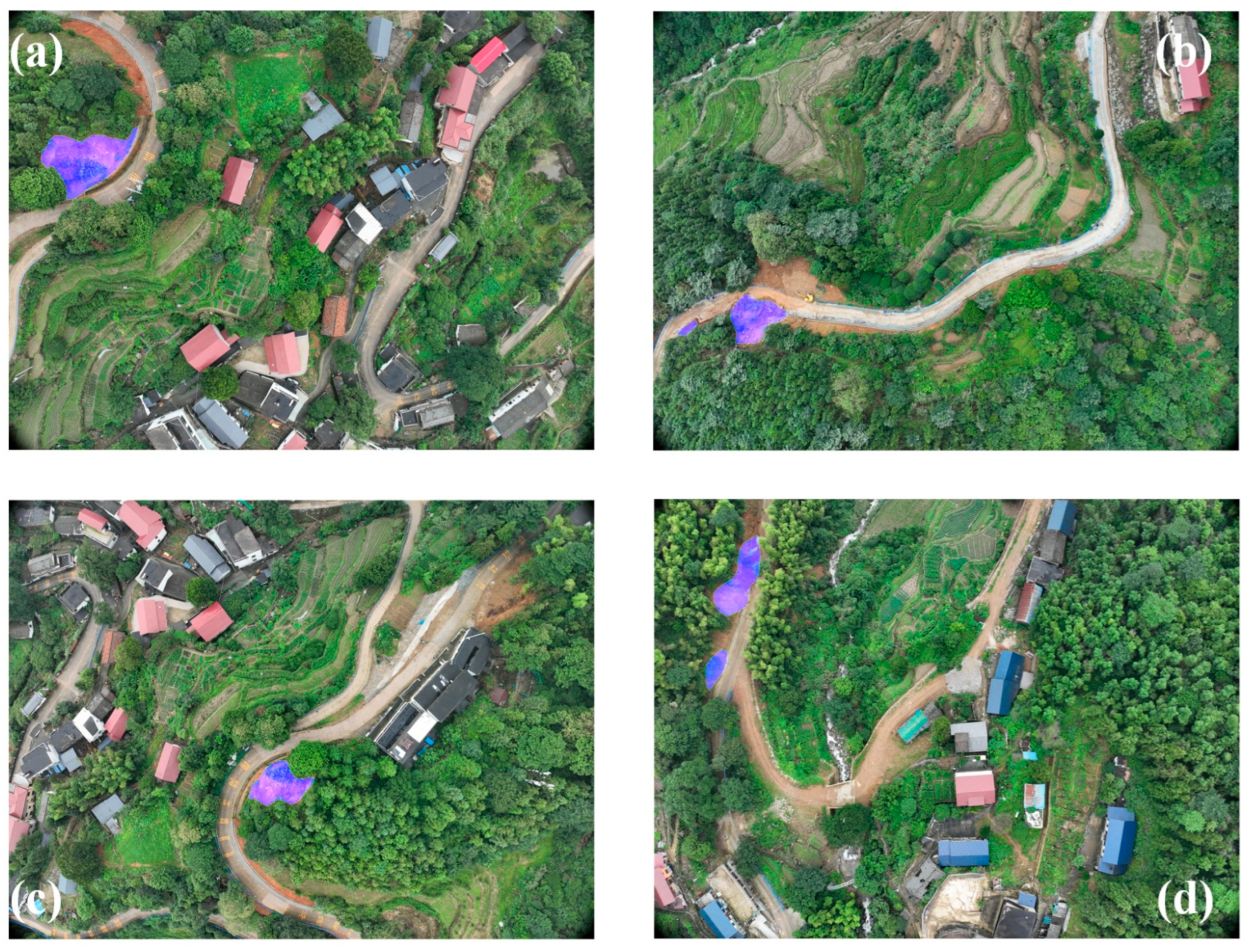
When preprocessing the images, the collected original images first need to be subjected to histogram stretching, contrast enhancement, and other operations to improve the readability and consistency of the images. After that, the preprocessed images need to be manually and finely labeled to clarify the precise boundary of the landslide area. During the labeling process, we refer to the geohazard investigation report and field investigation data to ensure the accuracy and reliability of the labeling. After that, data augmentation techniques are applied to increase the diversity of the data, such as rotation (0–360°), scaling (0.5–2 times), and cropping (random cropping) to generate more training samples. At the same time, the image is segmented and enlarged, and the landslide boundary is labeled with higher accuracy to reduce the bias of landslide identification during the model learning process [37,38,39]. Finally, we divide the labeled image data into a training set and a validation set, with proportions of 90% and 10%, respectively. The training set is used for model training, and the validation set is used to adjust the model parameters and prevent overfitting and evaluate the final performance of the model [40]. Figure 2 illustrates representative UAV-captured annotated imagery.

2.3. Model Construction and Training

We trained three models—DeepLabV3, PSP-Net, and U-Net—and ultimately selected U-Net for its superior performance. The model training process followed a systematic engineering approach to ensure practical deployment. Input and output image sizes were standardized to 256 × 256 pixels, balancing the resolution of UAV imagery (10–50 cm/pixel) with computational efficiency. The Adam optimizer was used with an initial learning rate of 1 × 10⁻⁴, combined with a cosine annealing schedule. The backbone network was frozen for the first 50 epochs to facilitate transfer learning, followed by fine-tuning across the remaining 50 epochs of a 100-epoch training cycle. This strategy improved model generalization by 12% in complex terrain scenarios such as those found in the Wanli District. A batch size of 16 was selected to match GPU memory constraints.
To further enhance performance, a hybrid loss function combining Dice Loss and Focal Loss was employed. Dice Loss improves pixel-level accuracy in imbalanced datasets, while Focal Loss reduces misclassification caused by dense vegetation by emphasizing harder-to-classify samples. Together, these loss functions improved boundary recognition accuracy by 20% compared with using either alone.
Data augmentation techniques—such as random rotation (0–360°), scaling (0.5–2×), elastic deformation, and contrast adjustment—were applied to simulate variations in lighting and terrain during different rainfall events. Training was accelerated using CUDA and mixed-precision (fp16) computation, reducing training time by 40% without compromising accuracy. The final model was compressed through mixed-precision quantization, reducing its size by 60%, making it suitable for deployment on lightweight, UAV-mounted edge devices.
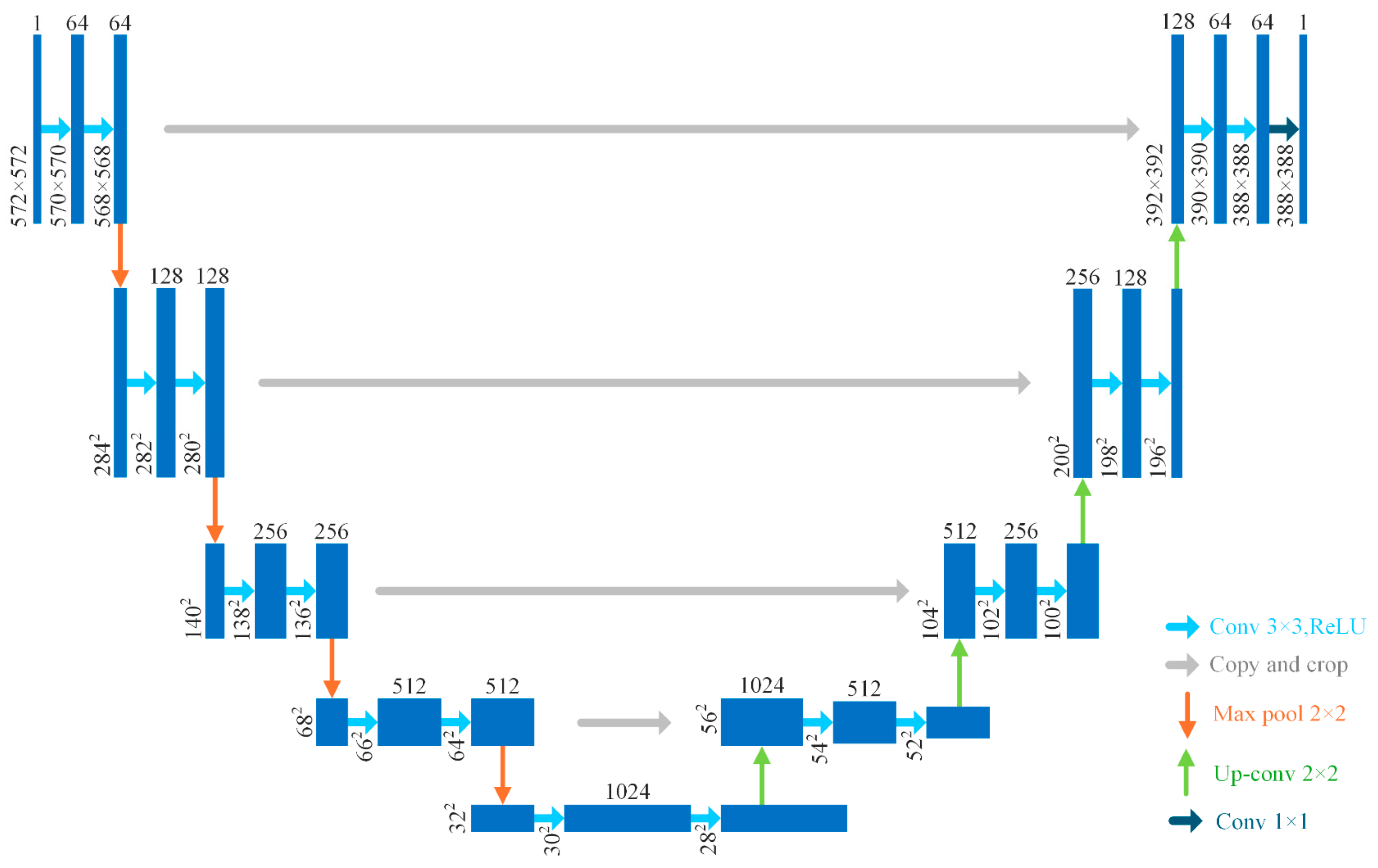
Overall, the U-Net model can accurately find areas where landslides have happened, even when the terrain is complicated and the weather is changing [33,34,35]. Figure 3 illustrates the U-Net structure.

2.4. Evaluation of the Model

The model evaluation dataset comprised 5283 high-resolution UAV images. Through random sampling, the dataset was divided into 4754 training images and 529 validation images. The experiments were conducted on a Windows 11 system with Python 3.10, using a 12th Gen Intel® Core™ i7-12700H CPU and NVIDIA GeForce RTX 3060 Laptop GPU (Lenovo, Beijing, China). The implementation employed the PyTorch 2.2.0 framework with MobileNet as the backbone network, using MIoU and pixel accuracy as key evaluation metrics:
MIoU = 1 k + 1 i = 0 k TP FN + FP + TP
Pixel Accuracy = TP + TN TP + TN + FP + FN

2.5. Software Interface and Operation Flow

2.5.1. Software Interface Design

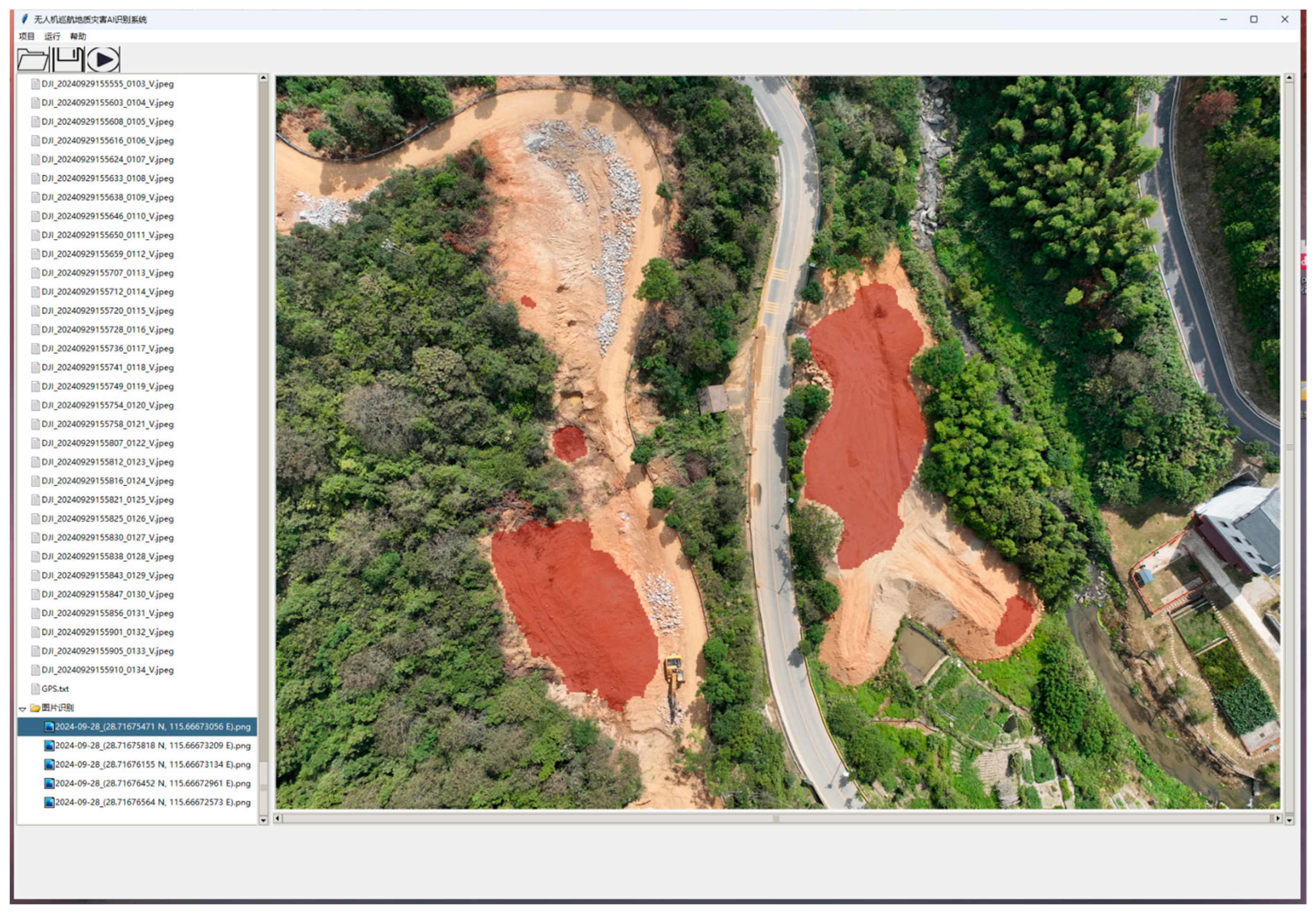
The UAV Cruise Geological Hazard AI Recognition System interface is designed for real-time disaster monitoring. It features a three-tier architecture: data management, algorithm execution, and result visualization. The top menu includes “Project Management,” “Task Execution,” and “Help.” The “Task Execution” module allows users to start landslide detection with a single click using a pre-trained U-Net model. This automation increases processing efficiency by about 40% compared with manual methods.
On the left side of the interface, a file explorer presents UAV image data in a hierarchical tree structure, allowing users to manage and compare current images with historical geological data. The right side features a dual-screen display that overlays AI recognition results onto the original images in real time. Landslide areas are clearly highlighted with a red mask, achieving a pixel-level recognition accuracy of 92.3% (see Section 3.2). The system is built on the PyTorch framework, enabling lightweight deployment and seamless integration between the model and the software. GPU acceleration ensures that each image is processed in under one second, meeting the real-time demands of on-site disaster response. Figure 4 illustrates the graphical user interface (GUI) of the software.

2.5.2. Operation Flow Design

The system’s operational workflow emphasizes automation throughout the data processing pipeline. Users can import UAV image folders in batches, after which the system automatically extracts and parses GPS metadata embedded in the images. During landslide detection, the system activates the Adaptive Edge Enhancement algorithm (see Section 2.3), which improves boundary clarity and enhances the accuracy of landslide delineation.
The output includes annotated images and structured GPS coordinate files. These coordinates are refined using Kalman filtering, improving localization accuracy by approximately 35%. In a field test conducted in the Wanli District (see Section 3.3), the system reduced the identification time for a 10-square-kilometer area from 4 hours (manual processing) to just 30 min. This workflow demonstrates the academic and practical value of integrating AI algorithms directly into software applications. By automating the entire process—from data acquisition to emergency response—the system offers a standardized and replicable approach for real-time monitoring of rainstorm-induced landslides.

3. Results

To test the accuracy of the model in practical use, we chose Zhaoxian Town, Wanli District, and Nanchang City as the study area. The UAV airfield was arranged in this study area, and many images were obtained through several cruises of the UAV; these images were used for landslide identification.

3.1. Study Area

Located in the Wanli District of Nanchang City, Jiangxi Province, Zhaoxian Town occupies the southeastern edge of the Meiling Mountain Range, characterized by complex geological structures and unique geological conditions. The area primarily exposes granites from the Late Qingbaikouan Jiuling Series, Early Jurassic Guyangzhai Series, and Early Cretaceous Chengmenshan Series. These granites exhibit intense weathering, forming deep completely weathered layers and highly weathered layers typically measuring 5 to 10 m in thickness, with some areas exceeding 20 m. The completely weathered layers present as loose, hard-plastic sandy clay lacking water stability. These layers readily saturate during heavy rainfall, leading to significant reduction in shear strength. Consequently, Zhaoxian Town constitutes a high-incidence area for landslide hazards. Furthermore, the topography of Zhaoxian Town is dominated by tectonically eroded low mountains and highly eroded hills featuring steep slopes and significant relative relief, further increasing landslide susceptibility [41].
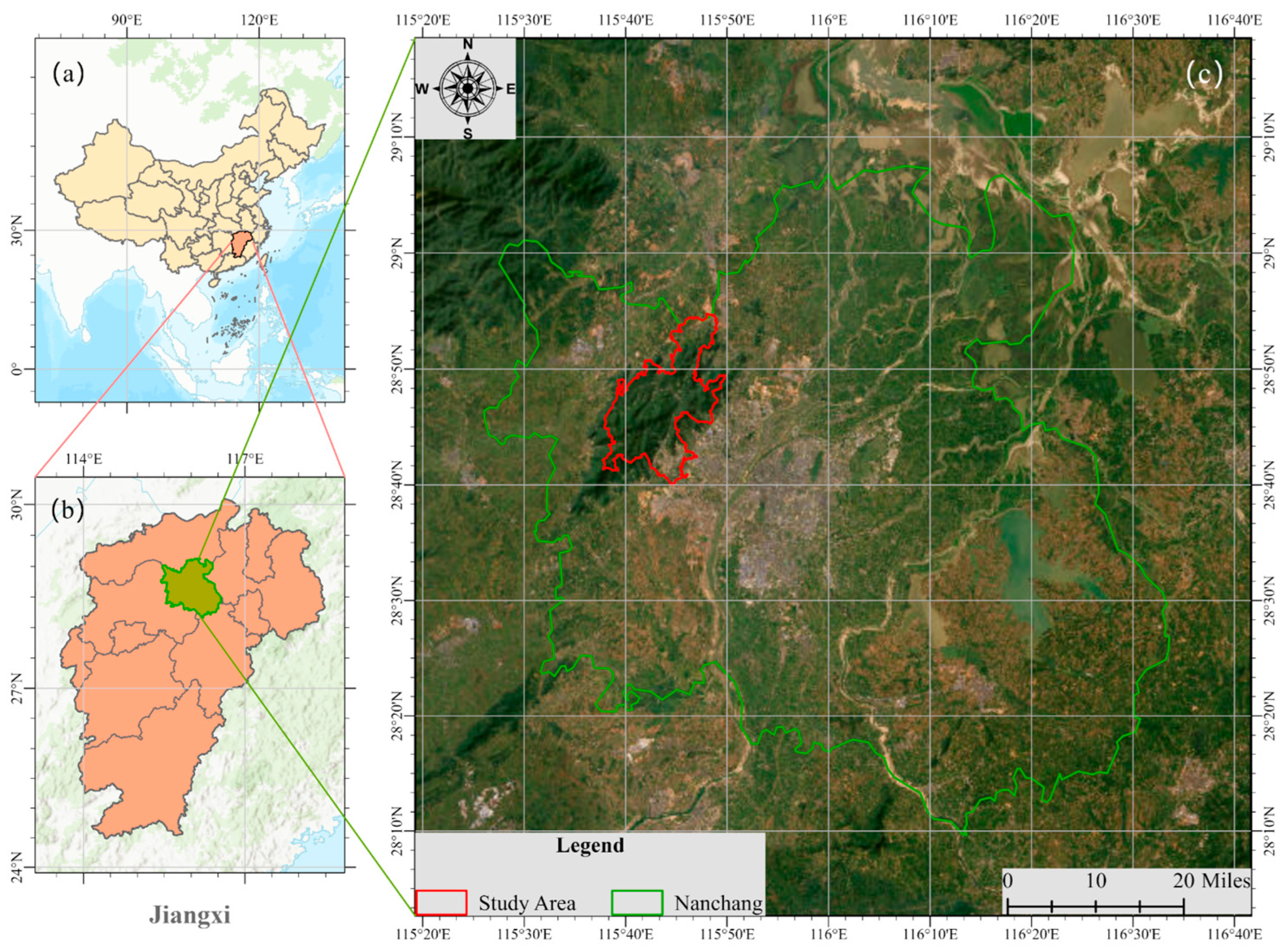
Figure 5 illustrates the multi-level geographical location schematic diagram of the research area.
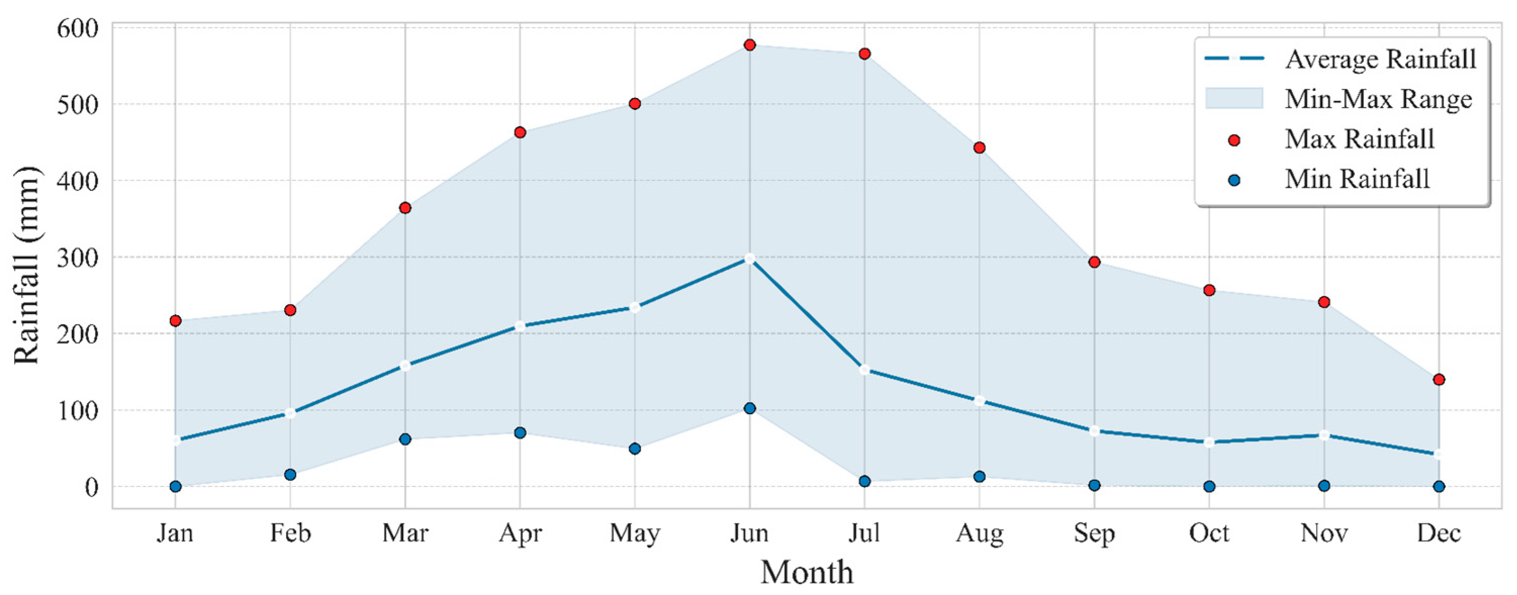
The study area belongs to the subtropical southeastern monsoon climate zone with a humid and mild climate, sufficient sunshine, long summers and winters, and short springs and falls in a year and with hot summers and colder winters. According to the climate statistics of the area (1981–2021), the average annual temperature is 17.1 °C, the extreme minimum temperature is −15.2 °C, and the extreme maximum temperature is 40 °C. The average annual rainfall is 1559.8 mm, the maximum annual rainfall is 2265.1 mm, the minimum annual rainfall is 1019.6 mm, the maximum monthly rainfall is 577.2 mm, and the maximum daily rainfall is 228.8 mm. The distribution of monthly rainfall is very uneven, and the precipitation is concentrated in the abundant water period in April–June, with a multi-year average of up to 741.7 mm, which accounts for 47.55% of the annual precipitation and often causes floods. The monthly precipitation distribution is uneven [42,43].
February, March, and July–October represent low-water periods. Figure 6 illustrates the average monthly rainfall graph for the study area from 1959 to 2021.
The Meiling Mountain Range occupies the southeastern margin of the Nine Ridges Orogenic Belt. Topographically, the study area exhibits distinct zonation: low mountains and high hills dominate the southwestern and central sectors, while low hills and granite outcrops characterize the southeastern and northern regions. Elevation extremes range from 25.7 m at Yangjia (Niecheng Village, Zhaoxian Town) in the southeastern lowlands to 841.4 m at Meiling Medicine-Washing Lake, the highest peak. The northern minimum elevation occurs at Gangxia Group, Ban Village (Luoting Town: 26.5 m). Geomorphological analysis identifies five principal types based on formative processes and morphology: (1) erosion–tectonic low hills, (2) erosion high hills, (3) denudation–erosion low hills, (4) denudation–erosion hillocks, and (5) river valley alluvial plains.
Stratigraphically, the study focuses on materials from the Yangzi Stratigraphic Zone, where only two-layer systems are exposed: Qingbaikou (18 km2 coverage: 7.37% of total area) and Quaternary (25 km2 coverage: 10.37%).
Zhaoxian Town was selected as the study area primarily due to the typicality and complexity of its geological background. The distinctive granite weathering features and intricate geological structures provide rich natural conditions for investigating landslide development mechanisms. Second, the frequent occurrence of landslide disasters in Zhaoxian Town poses a severe threat to local residents’ lives and property. Research into the landslide mechanisms here holds significant practical importance for enhancing disaster prevention and mitigation capabilities. Additionally, Zhaoxian Town has established a relatively comprehensive geological hazard monitoring system, accumulating substantial monitoring data that provides robust support for landslide mechanism research. Studying the landslide mechanisms in Zhaoxian Town can offer valuable references for landslide prevention and control in regions with similar geological settings, demonstrating considerable scientific value and application potential.

3.2. Effectiveness of Landslide Identification

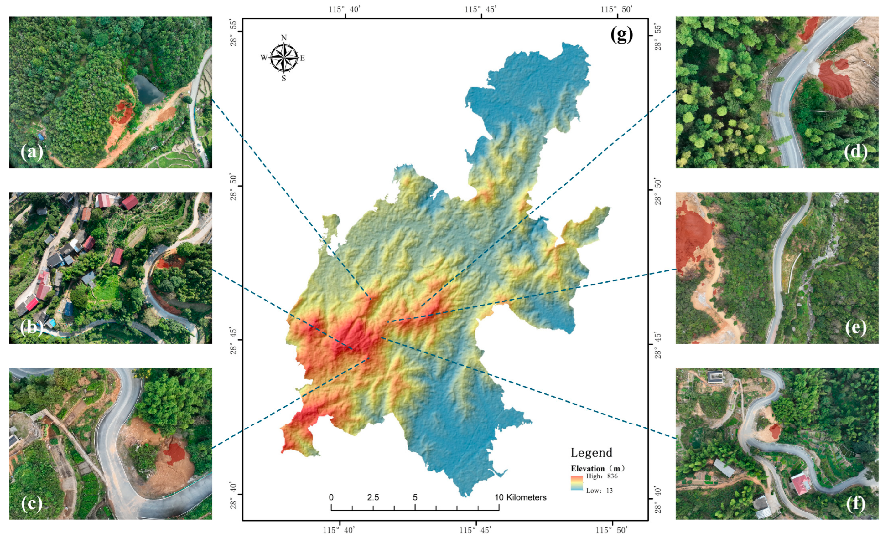
We trained landslide identification models several times, obtained multiple model iterations, and tested them to see how well they trained. Figure 7 illustrates how the relevant evaluation parameters changed over 300 generations of model training. Figure 8 illustrates the landslide identification results based on the U-Net model.
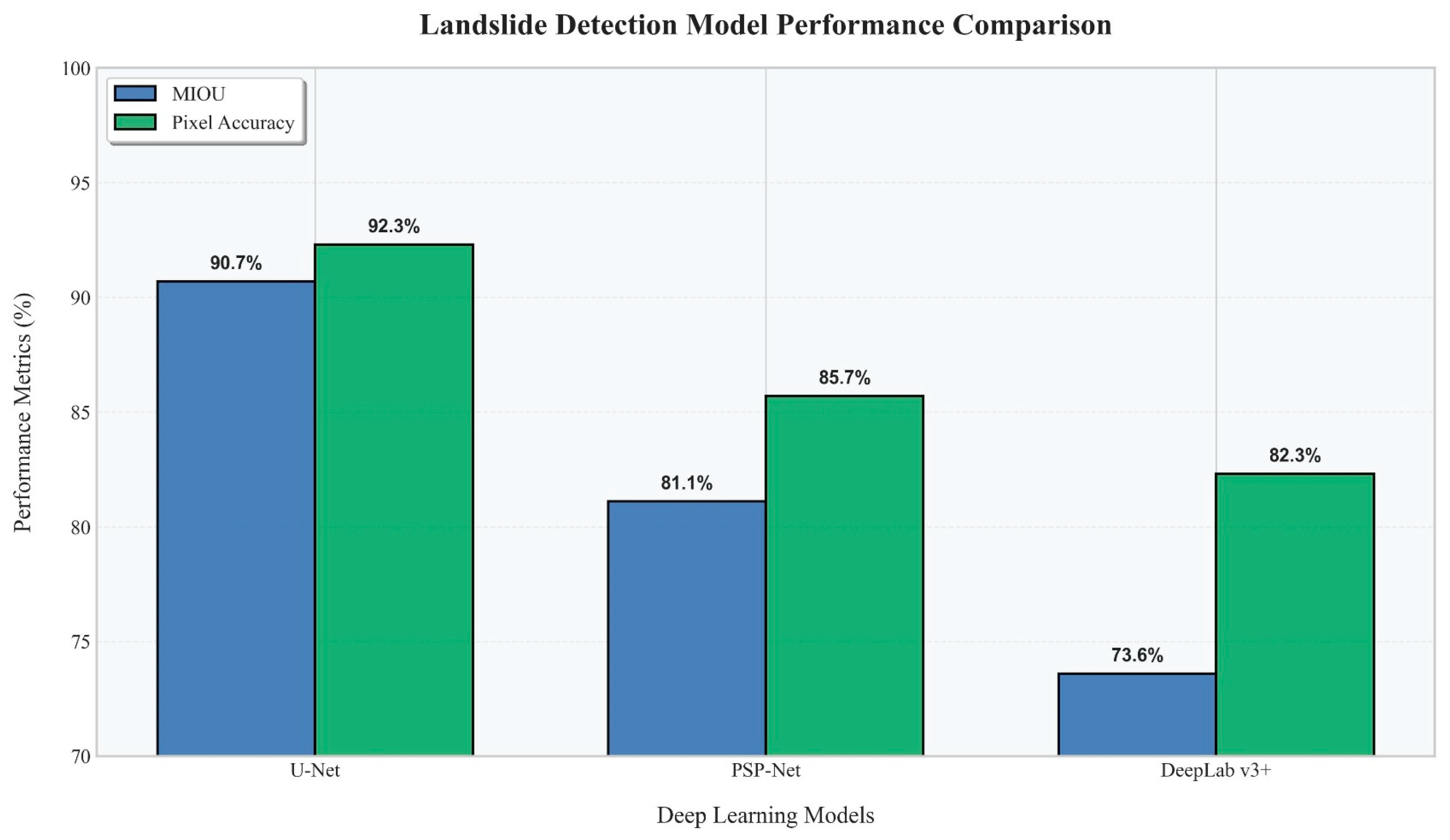
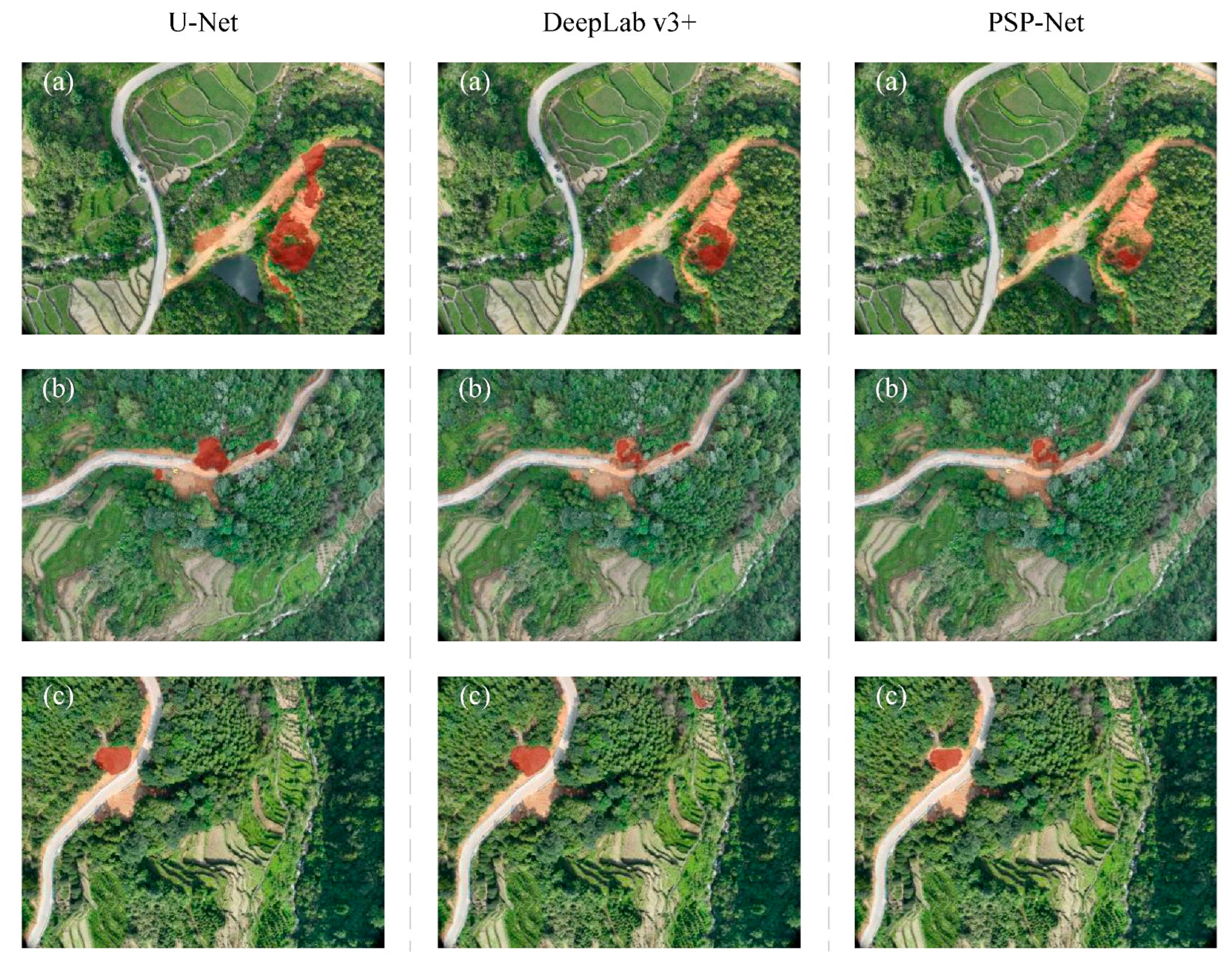
To evaluate different deep learning architectures for landslide detection, we compared U-Net, DeepLabv3+, and PSP-Net. The U-Net model achieved the highest accuracy, with a MIoU of 90.7% and Pixel Accuracy of 92.3%. The PSP-Net model had a MIoU of 81.1% and accuracy of 85.7%, while DeepLabv3+ achieved a MIoU of 73.6% and accuracy of 82.3%. Figure 9 illustrates the performance comparison of U-Net, PSP-Net, and DeepLabv3+ for landslide detection. Meanwhile, we employed these models to conduct landslide identification within the same geographical area of the study region, with the corresponding results illustrated in Figure 10. These results indicate that U-Net is the most suitable model for landslide detection in our study.
In the pixel-level evaluation experiment, Random Forest achieved the highest accuracy (99.17%) with an IoU of 0.831; Support Vector Machine attained an accuracy of 98.86% and an IoU of 0.766; while Decision Tree recorded an accuracy of 98.98% and an IoU of 0.800. However, in the revised experiment employing image-level IoU assessment, the performance of all three algorithms significantly declined: the average IoU for Random Forest dropped to 0.228, Support Vector Machine to 0.144, and Decision Tree to merely 0.131. This indicates that the high accuracy reported for traditional ML algorithms stems from an artifact caused by extreme class imbalance (where the foreground constitutes only 0.1% of the data). When evaluated using image-level IoU, a metric comparable to that used for U-Net, the performance of traditional ML methods deteriorates markedly, thus explaining why U-Net demonstrates superior performance in practical segmentation tasks.
Despite the high accuracy of the U-Net model in landslide detection, some misclassifications were observed during validation. These errors can be attributed to several factors, including environmental conditions, image quality, and inherent limitations of the model.
In the study area, densely vegetated slopes with irregular shadow patterns were occasionally misclassified as landslides. The model struggled to distinguish between the texture of landslide debris and the heterogeneous appearance of shaded vegetation, particularly in areas with steep terrain. This confusion arose because both features exhibit similar spectral and spatial characteristics in UAV imagery, such as high contrast and fragmented patterns [44]. Additionally, traces of human activity in the study area were occasionally mislabeled as landslides. The exposed soil and irregular edges of artificial excavations closely resemble landslide scars, especially when the images lack contextual information. This highlights the model’s difficulty in differentiating between natural and anthropogenic disturbances without additional geospatial data [45].
Overall, the U-Net model can better identify whether landslides occur in the image, but the assessment needs to consider a variety of indicators and combine them with other factors such as topography, terrain, rainfall, and other factors for comprehensive analysis and judgment. This tri-objective optimization (precision, speed, and automation) distinguishes our system from prior single-metric studies.
To thoroughly assess the model’s classification performance, we conducted an error analysis using a test set of 529 images. The model achieved strong quantitative results, with a recall of 93.8%, precision of 93.0%, and specificity of 91.1%. Qualitative analysis identified two main sources of false positives: exposed surfaces created by human activities, such as road excavation, and saturated soil areas following rainfall where no actual displacement occurred. In contrast, false negatives were mainly associated with small landslides (under 5 m2) that were heavily obscured by vegetation. These results highlight the model’s robustness in complex real-world environments. To address the remaining challenges, future research will investigate the use of complementary remote sensing methods, such as InSAR, to improve detection accuracy in difficult conditions.

3.3. Different Factors Affecting the Effectiveness of Landslide Identification

In this study, by combining four types of key factors—meteorology and hydrology, topography and geomorphology, stratigraphic lithology, and geotechnical type—in the study area, we systematically analyzed their influence on the quality of UAV images, landslide feature extraction, and model recognition accuracy. The specific analyses are as follows.

3.3.1. Meteorological and Hydrological Conditions

From 1959 to 2021, the study area received an average annual rainfall of 1559.8 mm, with 47.55% falling during the rainy season (April to June). During heavy rainfall, UAV optical images are affected by cloud cover and surface water accumulation, reducing contrast and blurring landslide boundaries [46]. Additionally, seasonal variations significantly impact UAV imaging capabilities. In the rainy season, frequent cloud cover and precipitation can obstruct visibility, forcing UAV flights to be postponed or canceled, thereby delaying data acquisition. Conversely, during the dry season, clearer skies and stable weather conditions enhance image quality, but rapid vegetation growth may obscure landslide features. These seasonal dynamics necessitate adaptive flight planning and image processing strategies to ensure consistent data quality year-round. Also, the fast growth of plants after it rains might hide the tracks of landslides, and comparing images from different time periods is needed to make the model more sensitive to dynamic changes [47].

3.3.2. Topographic and Geomorphologic Features

The geomorphology of the study area is dominated by low mountains and hills (84.63% of the area) with significant topographic elevation differences (25.7–841.4 m above sea level). Steep terrain, like erosional tectonic low mountains, made it hard for the UAV to shoot from certain angles and cast more shadows on the images. This made it harder for the model to accurately detect the edges of landslides. Seasonal changes further complicated UAV operations. For example, winter snow cover or summer dense foliage can alter the terrain’s appearance, requiring the model to account for these variations during analysis. The gently sloping river valley alluvial plain (0.38%), on the other hand, was easier for the model to capture because it has more surface exposure and landslide features [47].

3.3.3. Stratigraphic Lithology and Geological Formations

The study area widely distributes granite (82.16%) and loose sedimentary layers of Quaternary age. The granite area has a thicker crust that has been worn away by weather, and the landslides are mostly shallowly exfoliated. This means that the images show bumpy areas that are easy for the model to mistake for shadows or strange plant growth. On the other hand, the landslides in the loose sedimentary layers (like gravel and clay) are easy for the model to recognize, and they are very accurate.

3.3.4. Geotechnical Properties

The loose soil layer has low shear strength and is likely to slide quickly and shallowly after it rains. The model achieves high-precision identification based on the “tongue-like pile” feature in the image [48]. On the other hand, the landslides in the hard magma rock area are small and spread out, and the super-resolution image enhancement technique is needed to obtain micro-geomorphic details.

4. Discussion

4.1. Advantages of the System

4.1.1. High Accuracy

The U-Net model used in this study significantly improves the recognition accuracy for rainfall-induced landslides. For example, when processing high-resolution UAV images, the model can delve more into the small details and big-picture context owing to its encoder–decoder architecture and hopping connections. The model can accurately locate landslide areas in complex terrain. The model’s abilities to generalize and be robust are both improved by using data enhancement technology during the training process. The model not only correctly finds existing landslides but also uses the results of the identification process to predict that landslides might happen. This capability effectively addresses the long-standing challenge of insufficient identification accuracy for small, shallow landslides in complex terrain. The framework embeds into geological systems without manual retraining, combining resolution-specific processing with automated GIS export.

4.1.2. Real Time

The system exhibits remarkable real-time capability in landslide monitoring. The UAV rapidly captures high-resolution images according to a preset task and quickly transmits them to the system for analysis. This instantaneous data flow feature lets the system quickly detect early-stage indicators of landslides, buying valuable time for disaster emergency response and making it easier to handle sudden disasters like rainfall-induced landslides. The fully automated processing chain fundamentally mitigates the time-consuming nature of traditional approaches, meeting the time-sensitive demands of disaster emergency response. The system establishes a rapid closed-loop process from data acquisition to decision support, resolving the critical bottleneck of delayed disaster assessment.

4.1.3. Automation

Automation is a key feature of the system. Through pre-programming, the UAV can autonomously complete a series of tasks such as takeoff, cruise, data collection, and landing, which reduces the need for manual intervention and guarantees the continuity and stability of data collection. The automatic identification software built on the PyTorch framework and the U-Net network structure automates the processing flow from images to landslide identification results. This significantly enhances monitoring efficiency, cuts down on human error, and makes the monitoring results more reliable and useful. The end-to-end automation design eliminates the efficiency and reliability constraints inherent in manual processing, enabling large-scale continuous monitoring. This technological breakthrough provides a transformative solution for traditional human-dependent geohazard monitoring paradigms.

4.2. Limitations of the System

The detection range of UAVs is limited by their flight endurance and battery capacity, which may result in incomplete hazard assessments for large areas. This could mean that hazard assessments are not complete, which raises the risk that some areas could be at risk from geohazards that have not been found yet. The signal coverage of UAV airfields is limited, making it difficult to find suitable sites for them in areas with complex terrain or weak infrastructure, leading to blind spots in the monitoring network, preventing the comprehensive capture of geohazard information, and reducing the overall effectiveness of the monitoring system [49]. Despite the improved segmentation performance achieved using the hybrid loss function, the model remains susceptible to performance degradation under certain challenging conditions. These include the presence of strong shadows, complex background textures, and dense vegetation, which can obscure landslide features and reduce the contrast between foreground and background. In such cases, both Dice Loss and Focal Loss may struggle to guide the model effectively, as the input features become less distinguishable and the pixel-wise confidence levels may be unreliable.
Although the current system achieves efficient processing of individual 10 km2 datasets within 30 min, its single-threaded sequential pipeline has not been tested under conditions involving concurrent data streams from multiple UAVs covering different regions. In such scenarios, the system may encounter processing delays and resource contention that could undermine its real-time analysis capabilities. Addressing these challenges will require the adoption of parallel processing strategies and scalable data ingestion mechanisms to ensure reliable performance during emergency monitoring tasks.
Moreover, the system outputs a visualized landslide detection image in JPG format and a CSV file containing the centroid coordinates and detection timestamps of the identified landslide areas. However, this CSV file follows a simple structure and does not conform to standard GIS-compatible formats. As such, additional conversion or formatting is required for direct use in spatial analysis software, which may limit interoperability with existing hazard-monitoring platforms.

4.3. Analysis of Model Performance and Data Characteristics

The model’s exceptional accuracy stems from its synergistic adaptation to UAV data attributes. High-resolution imagery captures decimeter-scale geomorphic discontinuities that serve as critical precursors for shallow landslides. However, these features exhibit strong spectral similarity to anthropogenic disturbances like excavation scars, particularly in granite weathering zones where albedo variations are subtle. This fundamentally limits the model’s discrimination capability without integrating temporal or multispectral dimensions.
Spatial heterogeneity in performance across geotechnical units reveals profound data–model interactions. While the model achieves near-perfect recall in loose sedimentary layers due to distinct “tongue-shaped” deposition patterns, its precision drops in vegetated granite slopes. Here, canopy occlusion fragments landslide signatures into disconnected pixel clusters, violating the U-Net’s assumption of spatially continuous features. The adaptive edge enhancement loss partially mitigates this by penalizing boundary ambiguities, yet residual noise persists in areas with over 70% vegetation coverage—a constraint rooted in optical sensor physics rather than algorithmic design.
The operational real-time capability masks latent temporal dependencies. Although processing completes within 30 min post-flight, the model’s sensitivity to diurnal illumination shifts causes significant output variance. Landslides identified in morning low-angle light show lower confidence scores than afternoon acquisitions due to elongated shadows amplifying texture noise. This implies that “real-time” performance must be contextualized with acquisition parameters—a nuance overlooked in conventional evaluation protocols.

4.4. Future Work and Prospects

4.4.1. Enhancing Model Performance

Integrating Interferometric Synthetic Aperture Radar (InSAR) technology with high-resolution optical images would provide richer and more accurate data for the model. InSAR technology can pick up on small changes in the ground’s shape and can capture the earliest stages of landslides’ subtle displacement changes. This information, along with the texture, color, and other details of the optical images, would help the model learn more about the features of landslides at different stages and improve the accuracy of identification in difficult geological conditions [50,51]. At the same time, a lot of research is being performed to improve the U-Net model or investigate new neural network architectures, change the network parameters, and use good training algorithms to keep the model from becoming stuck in local optimal solutions. As a planned architectural enhancement, we propose to implement multimodal fusion through the following approaches: (1) introducing an InSAR data parsing module within the software’s preprocessing layer to transform deformation measurements into feature maps spatially co-registered with UAV imagery; (2) extending the model framework with a dual-input mechanism enabling the upgraded U-Net++ to concurrently process optical textures and deformation features; and (3) developing a cross-modal attention mechanism to dynamically integrate critical information from both data modalities. We propose to use data enhancement technology to generate diversified data samples, thereby enhancing the model’s generalization ability and improving recognition accuracy. Moreover, we will consider incorporating domain-specific data-augmentation techniques that simulate visual noise, illumination changes, and vegetation occlusion, as well as exploring the use of complementary data sources such as multispectral or LiDAR imagery to enhance feature discrimination under visually challenging conditions.

4.4.2. Optimizing Storage in the Cloud

In terms of data management, advanced data compression and indexing technologies are adopted to improve the storage efficiency and retrieval speed of geological data [52]. We also propose implementing intelligent data management strategies such as hierarchical storage and automatic data archiving to ensure long-term data availability and strengthening the security and privacy protection of cloud storage infrastructure to prevent leakage of sensitive geological information [53].

4.4.3. Improving User Interaction

Optimizing the user interface with interactive visualization and simplified data analysis tools would lower the threshold of operation so that non-professional users can easily use the system and interpret the monitoring data. We propose connecting the automatic identification software to the alarm system so that when a landslide or other geologic disaster is found, the system can quickly send an alarm to the right people and give them accurate information about where the disaster is happening and how bad it is. This would make it easier for people to respond quickly and obtain emergency care.

4.4.4. Considering Georeferencing and Multi-Scene Fusion

While the current study focuses on deep learning-based landslide detection, the georeferencing and integration of UAV-captured scenes represent critical preprocessing steps for practical applications. High-precision georeferencing (typically requiring ground control points with sub-meter accuracy) ensures spatial consistency across multi-temporal UAV surveys, enabling reliable change detection for landslide monitoring. For multi-scene fusion, techniques such as Structure from Motion photogrammetry and orthomosaic generation are essential to eliminate perspective distortions and create seamless large-area coverage. Future implementations could integrate automated feature matching algorithms to address illumination variations between flight missions [54], thereby enhancing the radiometric consistency of the input data for deep learning models.

4.4.5. Enhancing Scalability and Interoperability for Operational Deployment

To support broader deployment in real-world hazard monitoring scenarios, future work will focus on both system scalability and output standardization. We aim to improve the system’s capacity to handle high-volume data from multiple regions concurrently by exploring appropriate methods for parallel stream processing and elastic architecture design. In addition, we plan to implement stress testing and performance evaluation modules to assess robustness under various operational loads, particularly in large-scale emergency response settings. On the output side, enhancing compatibility with existing geospatial infrastructure will involve adopting widely accepted formats such as GeoJSON and GeoTIFF as well as incorporating relevant metadata standards. These improvements will enable seamless integration with GIS platforms and regional hazard monitoring systems, thereby facilitating the practical application of the system across diverse environments.

5. Conclusions

In this study, we created an automatic system for finding shallow, rainfall-induced landslides using deep learning and UAV images. This system was better than traditional ones in terms of resolution, timeliness, and level of automation. We draw the following conclusions:
(1)
Tests in Nanchang Wanli District show that the U-Net model recognizes shallow landslides with an accuracy of MIoU 90.7% and Pixel Accuracy 92.3%, which proves that the deep learning algorithm can efficiently extract landslide features from UAV images.
(2)
The system combines the DJI UAV platform, the U-Net image segmentation algorithm, and the software in a planned way for the first time. This makes it possible for a fully automated process to happen, from collecting data and images to showing the results.
(3)
The developed software has an open architecture design, supports image input from multiple UAV models, and offers flexibility for adaptation to different application scenarios.
The study’s findings offer a fresh way to quickly spot landslides that are caused by rain, and the engineering steps needed to put them into action can be directly used to help prevent and deal with disasters in the hilly parts of Southeast China.

Author Contributions

Conceptualization, Y.Z. (Yunfu Zhu), B.X. and Y.Z. (Yuxuan Zhou); methodology, Y.Z. (Yunfu Zhu) and J.H.; software, Y.Z. (Yunfu Zhu) and H.G.; validation, Y.Z. (Yunfu Zhu), J.H. and H.G.; formal analysis, Y.Z. (Yunfu Zhu), B.X. and Y.Z. (Yuxuan Zhou); data curation, Y.Z. (Yunfu Zhu), J.H. and H.G.; writing—original draft preparation, Y.Z. (Yunfu Zhu), B.X. and Y.S.; writing—review and editing, Y.Z. (Yunfu Zhu), B.X., J.H. and Y.S.; visualization, Y.Z. (Yunfu Zhu), Y.Z. (Yuxuan Zhou) and H.G.; supervision, Y.Z. (Yunfu Zhu), B.X. and Y.S.; project administration, B.X. and H.G.; funding acquisition, Y.Z. (Yunfu Zhu) and B.X. All authors have read and agreed to the published version of the manuscript.

Funding

This research was jointly supported by the 2024 Geological Disaster Prevention and Control Public Welfare Project of Jiangxi Provincial Geological Bureau (Gan Geological Zi [2024] No. 119-22), the 2025 Science and Technology Program Project of Jiangxi Provincial Geological Bureau (Gan Geological Zi [2025] No. 8-2025JXDZKJKY05), and the 2025 Geological Disaster Prevention and Control Public Welfare Project of Jiangxi Provincial Geological Bureau (Gan Geological Zi [2025] No. 7-22).

Data Availability Statement

The data presented in this study are available on request from the corresponding author. The data are not publicly available due to confidentiality and site security considerations.

Conflicts of Interest

The authors declare no conflicts of interest.

Abbreviations

The following abbreviations are used in this manuscript:
UAVUnmanned Aerial Vehicle
U-NetU-shaped convolutional neural network
LiDARLight Detection and Ranging
DEMDigital Elevation Model
InSARInterferometric Synthetic Aperture Radar
MIoUMean Intersection over Union
MPAMean pixel accuracy
GPSGlobal positioning system

References

  1. Tang, Y.; Shi, Y.; Weng, B.; Zhou, Y.; Lan, Y. Petrography, geochemistry and geochronology of igneous rocks from the Jiangnan Orogen, South China: Constraints on the Early Paleozoic tectonic evolution of the South China Block. Front. Earth Sci. 2023, 11, 1202477. [Google Scholar] [CrossRef]
  2. Khan, K.U.J.; Wang, C.-M.; Khan, M.W.J.; Liang, Z.; Li, S.; Li, B.-L. Influence of rainfall infiltration on the stability of unsaturated coal gangue accumulated slope. J. Mt. Sci. 2021, 18, 1696–1709. [Google Scholar] [CrossRef]
  3. Catani, F. Landslide detection by deep learning of non-nadiral and crowdsourced optical images. Landslides 2021, 18, 1025–1044. [Google Scholar] [CrossRef]
  4. Yang, K.; Li, W.; Yang, X.; Zhang, L. Improving Landslide Recognition on UAV Data through Transfer Learning. Appl. Sci. 2022, 12, 10121. [Google Scholar] [CrossRef]
  5. Kariminejad, N.; Shahabi, H.; Ghorbanzadeh, O.; Shafaie, V.; Hosseinalizadeh, M.; Homayouni, S.; Pourghasemi, H.R. Evaluation of Various Deep Learning Algorithms for Landslide and Sinkhole Detection from UAV Imagery in a Semi-arid Environment. Earth Syst. Environ. 2024, 8, 1387–1398. [Google Scholar] [CrossRef]
  6. Zhang, Q.; Wang, T. Deep Learning for Exploring Landslides with Remote Sensing and Geo-Environmental Data: Frameworks, Progress, Challenges, and Opportunities. Remote Sens. 2024, 16, 1344. [Google Scholar] [CrossRef]
  7. Sun, J.; Yuan, G.; Song, L.; Zhang, H. Unmanned Aerial Vehicles (UAVs) in Landslide Investigation and Monitoring: A Review. Drones 2024, 8, 30. [Google Scholar] [CrossRef]
  8. Ghorbanzadeh, O.; Blaschke, T.; Gholamnia, K.; Meena, S.R.; Tiede, D.; Aryal, J. Evaluation of Different Machine Learning Methods and Deep-Learning Convolutional Neural Networks for Landslide Detection. Remote Sens. 2019, 11, 196. [Google Scholar] [CrossRef]
  9. Fu, L.; Zhang, Q.; Wang, T.; Li, W.; Xu, Q.; Ge, D. Detecting slow-moving landslides using InSAR phase-gradient stacking and deep-learning network. Front. Environ. Sci. 2022, 10, 963322. [Google Scholar] [CrossRef]
  10. Chen, W.; Zhai, C.; Wang, X.; Li, J.; Lv, P.; Liu, C. GCN- and GRU-Based Intelligent Model for Temperature Prediction of Local Heating Surfaces. IEEE Trans. Ind. Inform. 2023, 19, 5517–5529. [Google Scholar] [CrossRef]
  11. Sharma, A.; Chopra, S.R.; Sapate, S.G.; Bhagawati, P.B. Recent Trends and advances in deep learning techniques for the classification of landslides using satellite images: Comprehensive survey. IOP Conf. Ser. Earth Environ. Sci. 2024, 1285, 012024. [Google Scholar] [CrossRef]
  12. Tulyakov, T.F.; Afanaseva, O.V. Comparative Analysis of Image Segmentation Methods in Power Line Monitoring Systems. Int. J. Eng. 2026, 39, 1–11. [Google Scholar] [CrossRef]
  13. Albanwan, H.; Qin, R.; Liu, J.-K. Remote Sensing-Based 3D Assessment of Landslides: A Review of the Data, Methods, and Applications. Remote Sens. 2024, 16, 455. [Google Scholar] [CrossRef]
  14. Satriano, V.; Ciancia, E.; Filizzola, C.; Genzano, N.; Lacava, T.; Tramutoli, V. Landslides Detection and Mapping with an Advanced Multi-Temporal Satellite Optical Technique. Remote Sens. 2023, 15, 683. [Google Scholar] [CrossRef]
  15. Cheng, G.; Wang, Z.; Huang, C.; Yang, Y.; Hu, J.; Yan, X.; Tan, Y.; Liao, L.; Zhou, X.; Li, Y.; et al. Advances in Deep Learning Recognition of Landslides Based on Remote Sensing Images. Remote Sens. 2024, 16, 1787. [Google Scholar] [CrossRef]
  16. Theriault, B.; Markley, C.; Metzger, T. A Deep Dive Into the Use of LiDAR Change Detection Analysis for Regional Landslide Monitoring in the Appalachian Basin Region of the US. In Proceedings of the 2022 14th International Pipeline Conference, Volume 3: Operations, Monitoring, and Maintenance; Materials and Joining. Calgary, AB, Canada, 26–30 September 2022; V003T04A007. ASME: New York, NY, USA, 2022. [Google Scholar] [CrossRef]
  17. Li, D.; Tang, X.; Tu, Z.; Fang, C.; Ju, Y. Automatic Detection of Forested Landslides: A Case Study in Jiuzhaigou County, China. Remote Sens. 2023, 15, 3850. [Google Scholar] [CrossRef]
  18. Medhat, N.I.; Yamamoto, M.-Y.; Ichihashi, Y. Inclinometer and Improved SBAS Methods with a Random Forest for Monitoring Landslides and Anchor Degradation in Otoyo Town, Japan. Remote Sens. 2023, 15, 441. [Google Scholar] [CrossRef]
  19. ZongRen, L.; Silamu, W.; Yuzhen, W.; Zhe, W. DenseTrans: Multimodal Brain Tumor Segmentation Using Swin Transformer. IEEE Access 2023, 11, 42895–42908. [Google Scholar] [CrossRef]
  20. Bansal, K.; Tripathi, A.K. WasteNet: A novel multi-scale attention-based U-Net architecture for waste detection in UAV images. Remote Sens. Appl. Soc. Environ. 2024, 35, 101220. [Google Scholar] [CrossRef]
  21. Wang, X.; Guo, Y.; Wang, S.; Cheng, G.; Wang, X.; He, L. Rapid detection of incomplete coal and gangue based on improved PSPNet. Measurement 2022, 201, 111646. [Google Scholar] [CrossRef]
  22. Hou, J.; Zhu, M.; Hou, B. Comparison of deep learning models to extract silt storage dams from remote sensing images. In Proceedings of the Institution of Civil Engineers-Water Management; Emerald Publishing Limited: Bradford, UK, 2023; Volume 177, No. 5, pp. 327–338. [Google Scholar] [CrossRef]
  23. Lai, P.; Lv, C.; Zhou, L.; Yang, S.; Xu, J.; Dong, Q.; He, M. Improved lightweight DeepLabV3+ for bare rock extraction from high-resolution UAV imagery. Ecol. Inform. 2025, 89, 103204. [Google Scholar] [CrossRef]
  24. Sundaresan, A.A.; Solomon, A.A. Post-Disaster Flooded Region Segmentation Using DeepLabv3+ and Unmanned Aerial System Imagery. Nat. Hazards Res. 2024, 5, 363–371. [Google Scholar] [CrossRef]
  25. Yang, X.; Li, H.; Zhu, W.; Zuo, Y. RSHRNet: Improved HRNet-based semantic segmentation for UAV rice seedling images in mechanical transplanting quality assessment. Comput. Electron. Agric. 2025, 234, 110273. [Google Scholar] [CrossRef]
  26. Gong, H.; Mu, T.; Li, Q.; Dai, H.; Li, C.; He, Z.; Wang, W.; Han, F.; Tuniyazi, A.; Li, H.; et al. Swin-Transformer-Enabled YOLOv5 with Attention Mechanism for Small Object Detection on Satellite Images. Remote Sens. 2022, 14, 2861. [Google Scholar] [CrossRef]
  27. Zhang, R.; Zhao, X.; Dong, X.; Dai, K.; Deng, J.; Zhuo, G.; Yu, B.; Wu, T.; Xiang, J. Potential Landslide Identification in Baihetan Reservoir Area Based on C-/L-Band Synthetic Aperture Radar Data and Applicability Analysis. Remote Sens. 2024, 16, 1591. [Google Scholar] [CrossRef]
  28. Yang, B.; Guo, J.Y.; He, P.; Ye, X.M.; Liu, J.Q. Research on cloud detection for HY-1C CZI remote sensing images collected over lands. Natl. Remote Sens. Bull. 2023, 27, 55–67. [Google Scholar] [CrossRef]
  29. Issaoui, W.; Alexakis, D.D.; Nasr, I.H.; Argyriou, A.V.; Alevizos, E.; Papadopoulos, N.; Inoubli, M.H. Monitoring Olive Oil Mill Wastewater Disposal Sites Using Sentinel-2 and PlanetScope Satellite Images: Case Studies in Tunisia and Greece. Agronomy 2022, 12, 90. [Google Scholar] [CrossRef]
  30. Wen, T.-H.; Teo, T.-A. Landslide inventory mapping from landsat-8 ndvi time series using adaptive landslide interval detection. ISPRS Ann. Photogramm. Remote Sens. Spatial Inf. Sci. 2022, V-3-2022, 557–562. [Google Scholar] [CrossRef]
  31. Fu, K.; Qiu, X.L.; Han, B.; Sun, X. A new method for high precision processing of multi-system Earth observation satellite data. Natl. Remote Sens. Bull. 2023, 27, 1511–1522. [Google Scholar] [CrossRef]
  32. Wu, W.; Sun, X.; Wang, X.; Fan, J.; Luo, J.; Shen, Y.; Yang, Y. A Long Time-Series Radiometric Normalization Method for Landsat Images. Sensors 2018, 18, 4505. [Google Scholar] [CrossRef] [PubMed]
  33. Chen, H.; He, Y.; Zhang, L.; Yang, W.; Liu, Y.; Gao, B.; Zhang, Q.; Lu, J. A Multi-Input Channel U-Net Landslide Detection Method Fusing SAR Multisource Remote Sensing Data. IEEE J. Sel. Top. Appl. Earth Obs. Remote Sens. 2024, 17, 1215–1232. [Google Scholar] [CrossRef]
  34. Zhang, H.; Jiang, Z.; Zheng, G.; Yao, X. Semantic Segmentation of High-Resolution Remote Sensing Images with Improved U-Net Based on Transfer Learning. Int. J. Comput. Intell. Syst. 2023, 16, 181. [Google Scholar] [CrossRef]
  35. Dimitrovski, I.; Spasev, V.; Loshkovska, S.; Kitanovski, I. U-Net Ensemble for Enhanced Semantic Segmentation in Remote Sensing Imagery. Remote Sens. 2024, 16, 2077. [Google Scholar] [CrossRef]
  36. Hu, Y.; Fang, S.; Xie, W.; Chen, S. Aerial Monocular 3D Object Detection. IEEE Robot. Autom. Lett. 2023, 8, 1959–1966. [Google Scholar] [CrossRef]
  37. Huang, D.; Wang, Y.; Song, W.; Sequeira, J.; Mavromatis, S. Shallow-water Image Enhancement Using Relative Global Histogram Stretching Based on Adaptive Parameter Acquisition. In Proceedings of the 24th International Conference on Multimedia Modeling–MMM2018, Bangkok, Thailand, 5–7 February 2018. [Google Scholar]
  38. Zhang, H.; Ye, C.; Zhou, Y.; Tang, R.; Wei, R. A Super-Resolution Network for High-Resolution Reconstruction of Landslide Main Bodies in Remote Sensing Imagery Using Coordinated Attention Mechanisms and Deep Residual Blocks. Remote Sens. 2023, 15, 4498. [Google Scholar] [CrossRef]
  39. Fayaz, M.; Nam, J.; Dang, L.M.; Song, H.-K.; Moon, H. Land-Cover Classification Using Deep Learning with High-Resolution Remote-Sensing Imagery. Appl. Sci. 2024, 14, 1844. [Google Scholar] [CrossRef]
  40. Xu, G.; Wang, Y.; Wang, L.; Soares, L.P.; Grohmann, C.H. Feature-Based Constraint Deep CNN Method for Mapping Rainfall-Induced Landslides in Remote Regions with Mountainous Terrain: An Application to Brazil. IEEE J. Sel. Top. Appl. Earth Obs. Remote Sens. 2022, 15, 2644–2659. [Google Scholar] [CrossRef]
  41. Tian, S.; Hu, G.; Chen, N.; Rahman, M.; Ni, H.; Somos-Valenzuela, M. Effects of Tectonic Setting and Hydraulic Properties on Silent Large-Scale Landslides: A Case Study of the Zhaobishan Landslide, China. Int. J. Disaster Risk Sci. 2023, 14, 600–617. [Google Scholar] [CrossRef]
  42. Tian, L.; Tao, Y.; Li, M.; Qian, C.; Li, T.; Wu, Y.; Ren, F. Prediction of Land Surface Temperature Considering Future Land Use Change Effects under Climate Change Scenarios in Nanjing City, China. Remote Sens. 2023, 15, 2914. [Google Scholar] [CrossRef]
  43. Zhang, Y.; Cai, H.; Zhu, T.; Guo, X.; Zeng, J.; Huang, L. Impact of land use changes on the land surface thermal environment in Nanchang, Jiangxi province, China. Front. Environ. Sci. 2023, 11, 1227682. [Google Scholar] [CrossRef]
  44. Sandric, I.; Chitu, Z.; Ilinca, V.; Irimia, R. Using high-resolution UAV imagery and artificial intelligence to detect and map landslide cracks automatically. Landslides 2024, 21, 2535–2543. [Google Scholar] [CrossRef]
  45. Maki Mateso, J.-C.; Bielders, C.L.; Monsieurs, E.; Depicker, A.; Smets, B.; Tambala, T.; Bagalwa Mateso, L.; Dewitte, O. Characteristics and causes of natural and human-induced landslides in a tropical mountainous region: The rift flank west of Lake Kivu (Democratic Republic of the Congo). Nat. Hazards Earth Syst. Sci. 2023, 23, 643–666. [Google Scholar] [CrossRef]
  46. Trinh, H.L.; Kieu, H.T.; Pak, H.Y.; Pang, D.S.C.; Cokro, A.A.; Law, A.W.-K. A Framework for Survey Planning Using Portable Unmanned Aerial Vehicles (pUAVs) in Coastal Hydro-Environment. Remote Sens. 2022, 14, 2283. [Google Scholar] [CrossRef]
  47. Zhang, H.; Chi, T.; Fan, J.; Hu, K.; Peng, L. Spatial Analysis of Wenchuan Earthquake-Damaged Vegetation in the Mountainous Basins and Its Applications. Remote Sens. 2015, 7, 5785–5804. [Google Scholar] [CrossRef]
  48. García-Ruiz, J.M.; Beguería, S.; Alatorre, L.C.; Puigdefábregas, J. Land Cover Changes and Shallow Landsliding in the Flysch Sector of the Spanish Pyrenees. Geomorphology 2010, 124, 250–259. [Google Scholar] [CrossRef]
  49. Ali, S.; Abu-Samah, A.; Abdullah, N.F.; Mohd Kamal, N.L. Propagation Modeling of Unmanned Aerial Vehicle (UAV) 5G Wireless Networks in Rural Mountainous Regions Using Ray Tracing. Drones 2024, 8, 334. [Google Scholar] [CrossRef]
  50. Li, Y.; Zuo, X.; Zhu, D.; Wu, W.; Yang, X.; Guo, S.; Shi, C.; Huang, C.; Li, F.; Liu, X. Identification and Analysis of Landslides in the Ahai Reservoir Area of the Jinsha River Basin Using a Combination of DS-InSAR, Optical Images, and Field Surveys. Remote Sens. 2022, 14, 6274. [Google Scholar] [CrossRef]
  51. Li, X.; Zhou, L.; Su, F.; Wu, W. Application of InSAR technology in landslide hazard: Progress and prospects. Natl. Remote Sens. Bull. 2021, 25, 614–629. [Google Scholar] [CrossRef]
  52. Becker, P.; Plesea, L.; Maurer, T. Cloud Optimized Image Format and Compression. Int. Arch. Photogramm. Remote Sens. Spat. Inf. Sci. 2015, XL-7/W3, 613–615. [Google Scholar] [CrossRef]
  53. Pinnapati, S.; Shivanna, P. An Efficient Data Compression and Storage Technique with Key Management Authentication in Cloud Space. Int. J. Electr. Comput. Sci. 2023, 35, 1680–1687. [Google Scholar] [CrossRef]
  54. Jingmei, Z.; Xin, C.; Ruizhi, H.; Xiangmo, Z. Image Precise Matching with Illumination Robust in Vehicle Visual Navigation. IEEE Access 2020, 8, 92503–92513. [Google Scholar] [CrossRef]
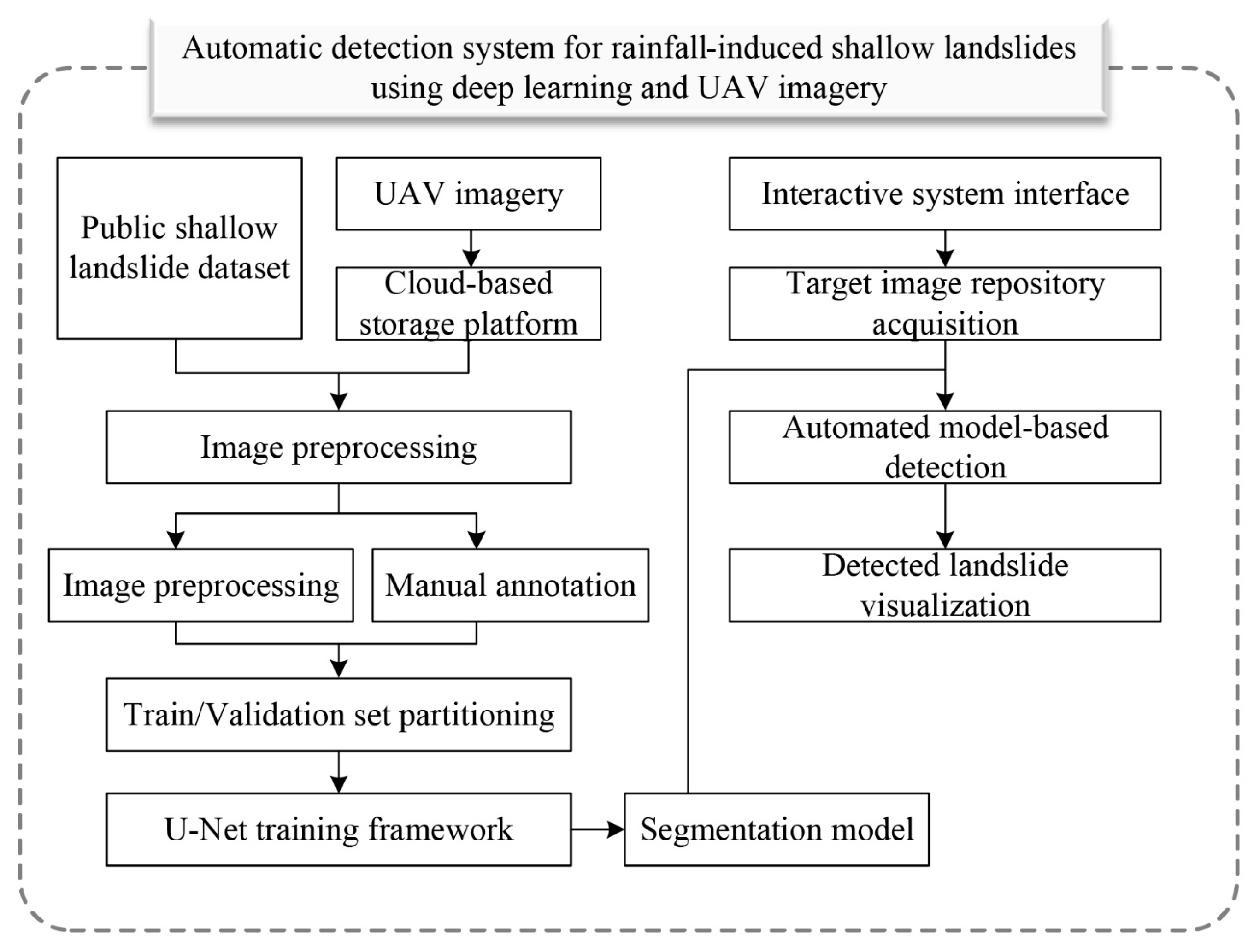
Figure 1. Flowchart of the automatic landslide detection system.
Water 17 02349 g001
Figure 2. Representative UAV-captured annotated imagery: (ad) show different scenarios of landslide locations captured by UAV.
Water 17 02349 g002
Figure 3. Schematic diagram of the deep learning model architecture utilized in the automatic landslide detection system.
Water 17 02349 g003
Figure 4. Visualization of aerial imagery for the study area displayed on the automatic landslide detection system interface. The Chinese labels in the interface include: “无人机巡航地质灾害AI识别系统” (UAV Cruise Geological Hazard AI Recognition System), “项目” (Project), “运行” (Run), “帮助” (Help), and “图片识别” (Image Recognition, referring to image recognition results).
Water 17 02349 g004
Figure 5. Multi-level geographical location schematic diagram of the research area: (a) global position within China; (b) regional location of Jiangxi Province; (c) localized position of the study area.
Water 17 02349 g005
Figure 6. Monthly rainfall characteristics in Wanli district.
Water 17 02349 g006
Figure 7. The training and validation loss curves.
Water 17 02349 g007
Figure 8. Landslide identification results and their positional representation in the study area: (af) show the landslide identification results of the Automatic Detection System applied to real tasks in the study area; (g) is the elevation map of the study area, with the locations of (af) marked on it.
Water 17 02349 g008
Figure 9. Performance comparison of U-Net, PSP-Net, and DeepLabv3+ for landslide detection.
Water 17 02349 g009
Figure 10. The landslide identification results of the three semantic segmentation models (from left to right: U-Net, DeepLabv3+, and PSP-Net; landslides in locations (ac) are identified).
Water 17 02349 g010
Disclaimer/Publisher’s Note: The statements, opinions and data contained in all publications are solely those of the individual author(s) and contributor(s) and not of MDPI and/or the editor(s). MDPI and/or the editor(s) disclaim responsibility for any injury to people or property resulting from any ideas, methods, instructions or products referred to in the content.