Automatic Detection System for Rainfall-Induced Shallow Landslides in Southeastern China Using Deep Learning and Unmanned Aerial Vehicle Imagery
Abstract
1. Introduction
1.1. Background of the Study
1.2. Synthesis of Work Related to Rainfall Landslide Detection
| Architecture | Key Findings | Technical Limitations |
|---|---|---|
| U-Net | Excels in edge detection but struggles with long-range dependencies; accuracy drops under high brightness/contrast [19,20] | Limited long-range dependency modeling; degrades under high-contrast lighting |
| PSP-Net | Superior multi-scale context aggregation; produces sharp edges but sensitive to learning-rate tuning [21,22] | Fixed pooling levels hinder irregular object segmentation |
| DeepLabv3+ | Robust to scale variations; achieves > 95% OA in structured landscapes but suffers from boundary shifts [23,24] | Atrous convolution leads to boundary fragmentation |
| HRNet | Maintains high-resolution features; stable in small datasets but computationally intensive [25] | High memory footprint for 3D deployment |
| Swin Trans | SOTA global context modeling; +3.2 MIoU gains over CNNs but requires extensive pretraining [26] | Quadratic self-attention complexity; slow receptive field expansion |
1.3. Existing Problems
1.4. The Main Research Work of This Paper
2. Materials and Methods
2.1. Overview
2.2. Data Acquisition and Preprocessing
2.3. Model Construction and Training
2.4. Evaluation of the Model
2.5. Software Interface and Operation Flow
2.5.1. Software Interface Design
2.5.2. Operation Flow Design
3. Results
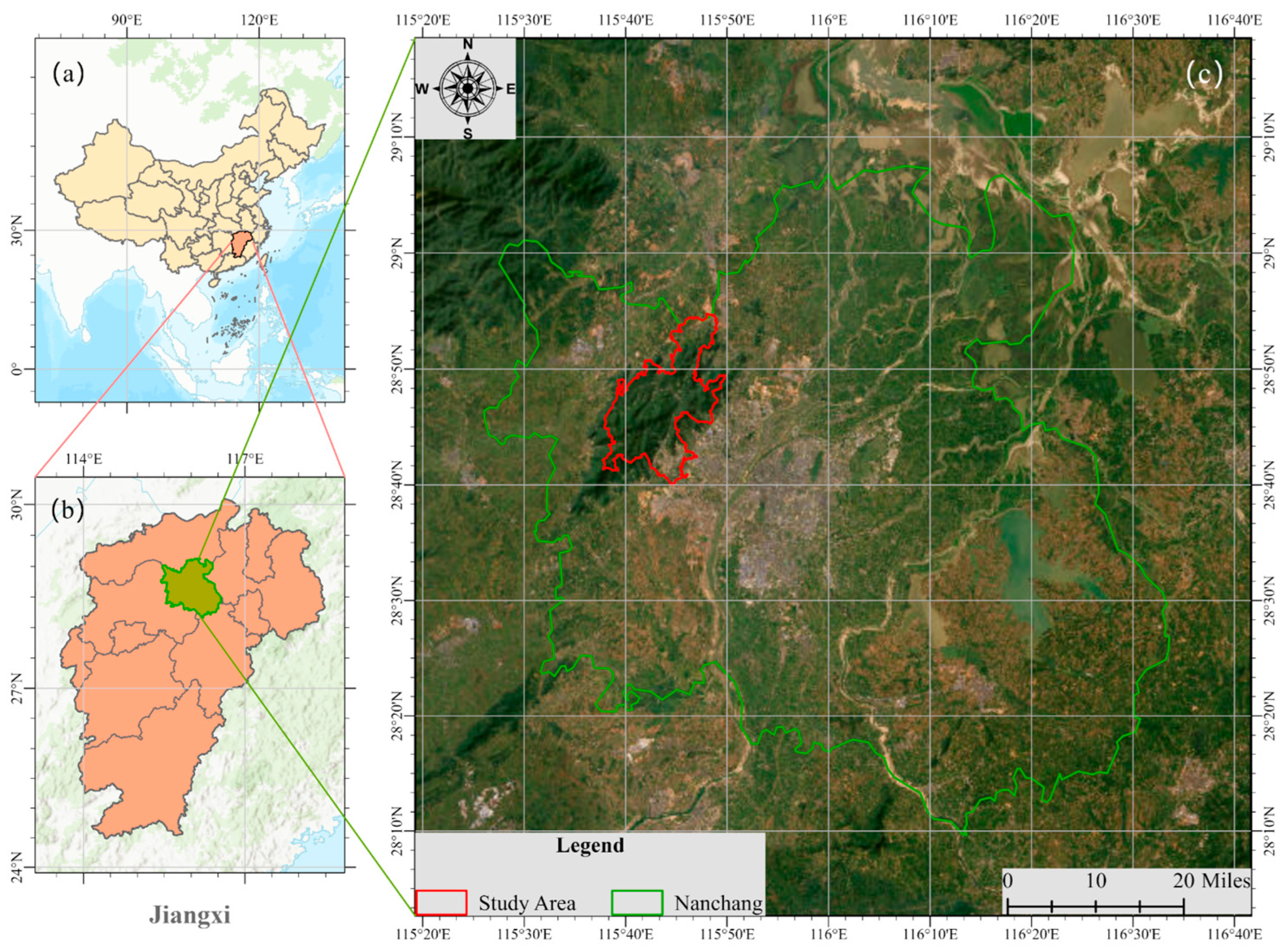
3.1. Study Area
3.2. Effectiveness of Landslide Identification
3.3. Different Factors Affecting the Effectiveness of Landslide Identification
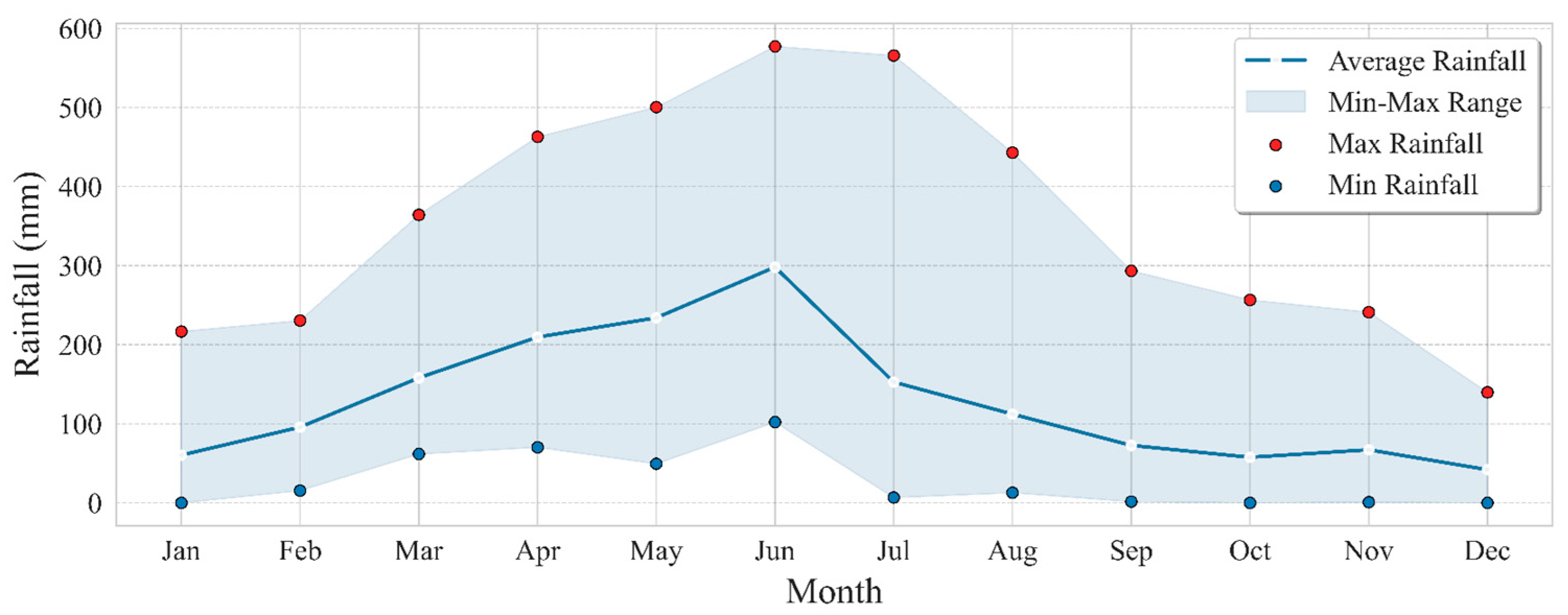
3.3.1. Meteorological and Hydrological Conditions
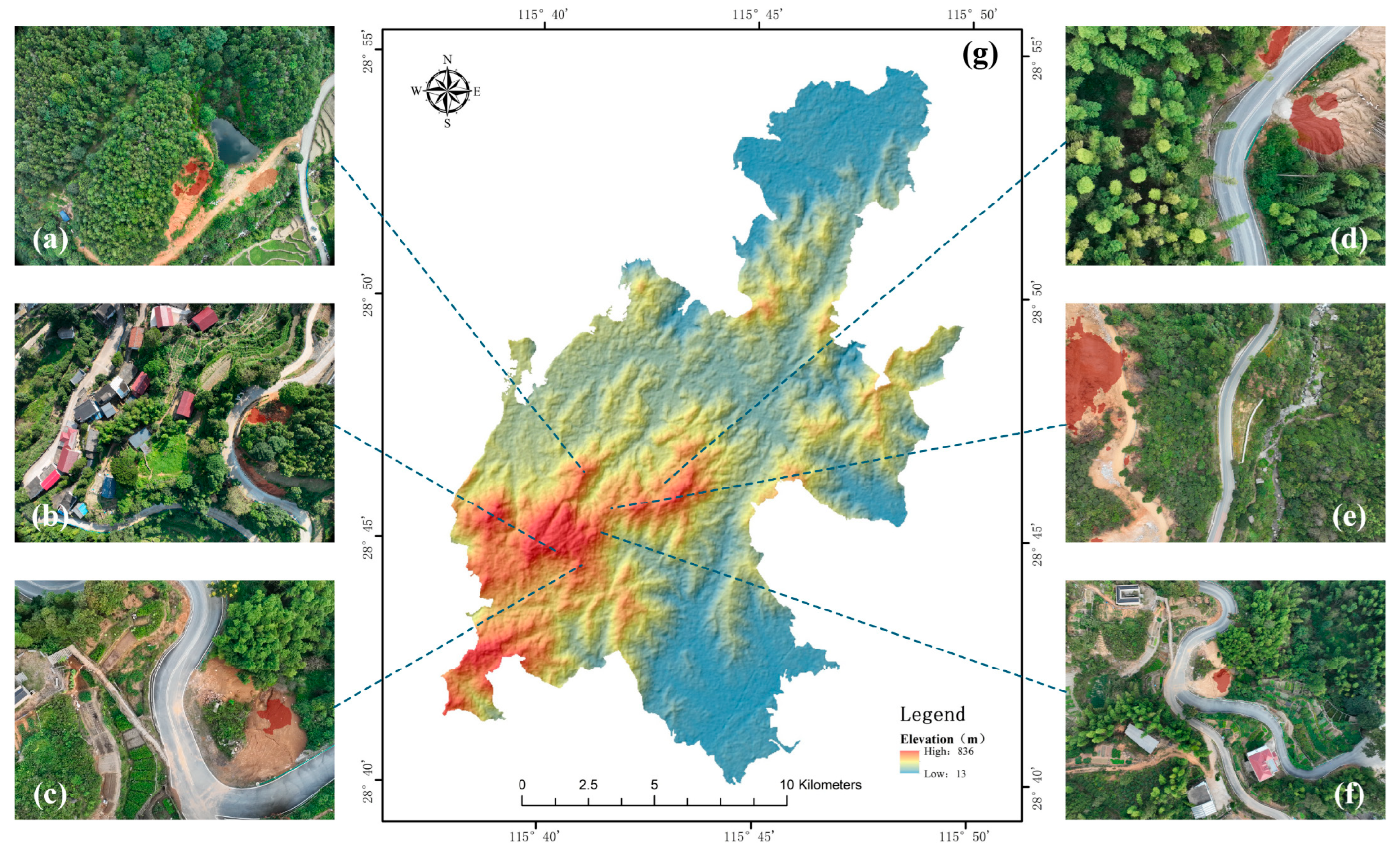
3.3.2. Topographic and Geomorphologic Features
3.3.3. Stratigraphic Lithology and Geological Formations
3.3.4. Geotechnical Properties
4. Discussion
4.1. Advantages of the System
4.1.1. High Accuracy
4.1.2. Real Time
4.1.3. Automation
4.2. Limitations of the System
4.3. Analysis of Model Performance and Data Characteristics
4.4. Future Work and Prospects
4.4.1. Enhancing Model Performance
4.4.2. Optimizing Storage in the Cloud
4.4.3. Improving User Interaction
4.4.4. Considering Georeferencing and Multi-Scene Fusion
4.4.5. Enhancing Scalability and Interoperability for Operational Deployment
5. Conclusions
- (1)
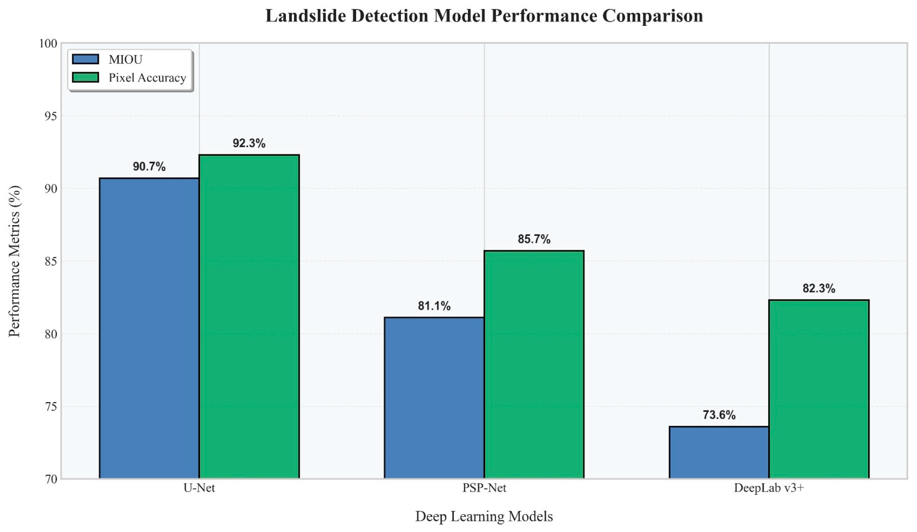
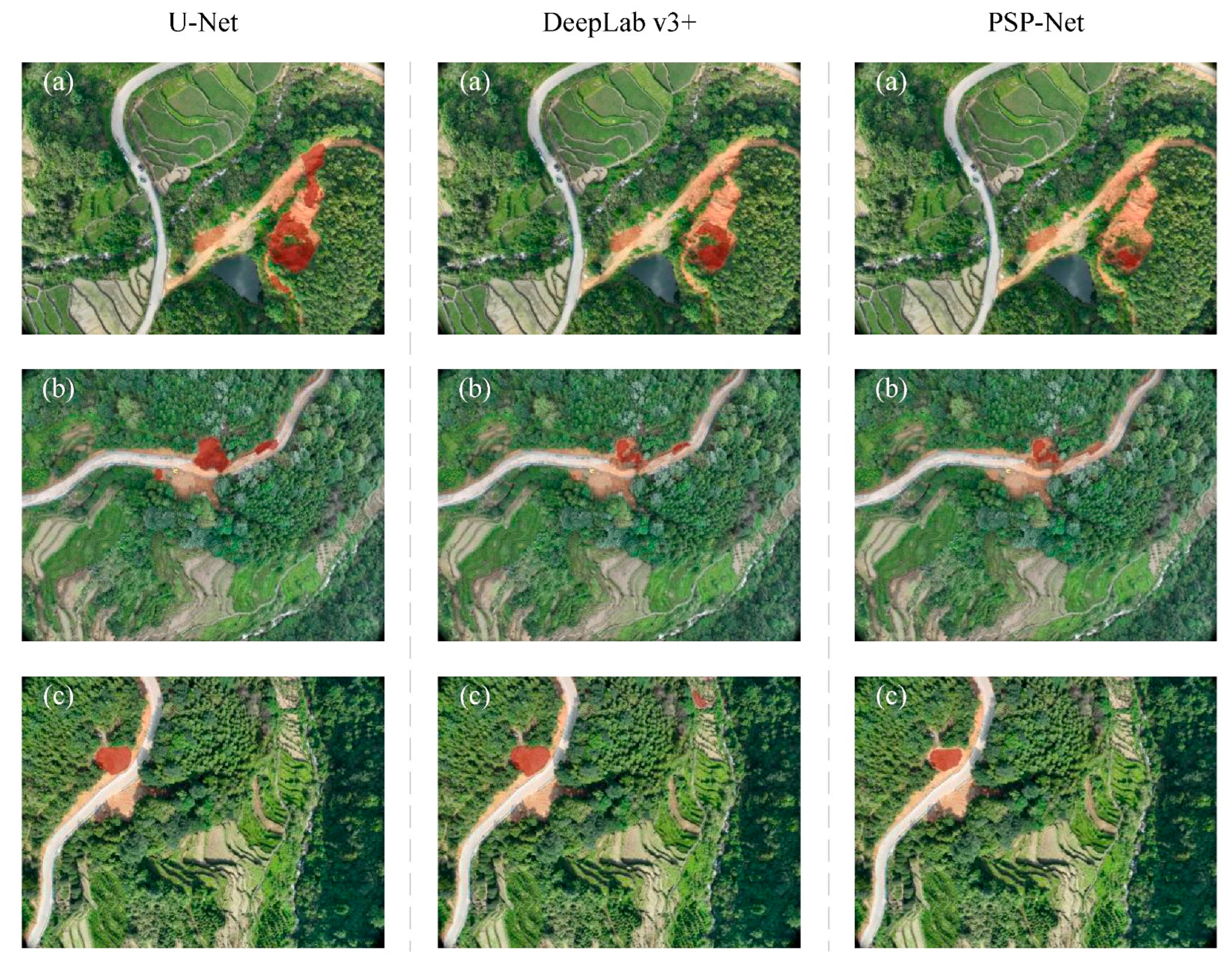
- Tests in Nanchang Wanli District show that the U-Net model recognizes shallow landslides with an accuracy of MIoU 90.7% and Pixel Accuracy 92.3%, which proves that the deep learning algorithm can efficiently extract landslide features from UAV images.
- (2)
- The system combines the DJI UAV platform, the U-Net image segmentation algorithm, and the software in a planned way for the first time. This makes it possible for a fully automated process to happen, from collecting data and images to showing the results.
- (3)
- The developed software has an open architecture design, supports image input from multiple UAV models, and offers flexibility for adaptation to different application scenarios.
Author Contributions
Funding
Data Availability Statement
Conflicts of Interest
Abbreviations
| UAV | Unmanned Aerial Vehicle |
| U-Net | U-shaped convolutional neural network |
| LiDAR | Light Detection and Ranging |
| DEM | Digital Elevation Model |
| InSAR | Interferometric Synthetic Aperture Radar |
| MIoU | Mean Intersection over Union |
| MPA | Mean pixel accuracy |
| GPS | Global positioning system |
References
- Tang, Y.; Shi, Y.; Weng, B.; Zhou, Y.; Lan, Y. Petrography, geochemistry and geochronology of igneous rocks from the Jiangnan Orogen, South China: Constraints on the Early Paleozoic tectonic evolution of the South China Block. Front. Earth Sci. 2023, 11, 1202477. [Google Scholar] [CrossRef]
- Khan, K.U.J.; Wang, C.-M.; Khan, M.W.J.; Liang, Z.; Li, S.; Li, B.-L. Influence of rainfall infiltration on the stability of unsaturated coal gangue accumulated slope. J. Mt. Sci. 2021, 18, 1696–1709. [Google Scholar] [CrossRef]
- Catani, F. Landslide detection by deep learning of non-nadiral and crowdsourced optical images. Landslides 2021, 18, 1025–1044. [Google Scholar] [CrossRef]
- Yang, K.; Li, W.; Yang, X.; Zhang, L. Improving Landslide Recognition on UAV Data through Transfer Learning. Appl. Sci. 2022, 12, 10121. [Google Scholar] [CrossRef]
- Kariminejad, N.; Shahabi, H.; Ghorbanzadeh, O.; Shafaie, V.; Hosseinalizadeh, M.; Homayouni, S.; Pourghasemi, H.R. Evaluation of Various Deep Learning Algorithms for Landslide and Sinkhole Detection from UAV Imagery in a Semi-arid Environment. Earth Syst. Environ. 2024, 8, 1387–1398. [Google Scholar] [CrossRef]
- Zhang, Q.; Wang, T. Deep Learning for Exploring Landslides with Remote Sensing and Geo-Environmental Data: Frameworks, Progress, Challenges, and Opportunities. Remote Sens. 2024, 16, 1344. [Google Scholar] [CrossRef]
- Sun, J.; Yuan, G.; Song, L.; Zhang, H. Unmanned Aerial Vehicles (UAVs) in Landslide Investigation and Monitoring: A Review. Drones 2024, 8, 30. [Google Scholar] [CrossRef]
- Ghorbanzadeh, O.; Blaschke, T.; Gholamnia, K.; Meena, S.R.; Tiede, D.; Aryal, J. Evaluation of Different Machine Learning Methods and Deep-Learning Convolutional Neural Networks for Landslide Detection. Remote Sens. 2019, 11, 196. [Google Scholar] [CrossRef]
- Fu, L.; Zhang, Q.; Wang, T.; Li, W.; Xu, Q.; Ge, D. Detecting slow-moving landslides using InSAR phase-gradient stacking and deep-learning network. Front. Environ. Sci. 2022, 10, 963322. [Google Scholar] [CrossRef]
- Chen, W.; Zhai, C.; Wang, X.; Li, J.; Lv, P.; Liu, C. GCN- and GRU-Based Intelligent Model for Temperature Prediction of Local Heating Surfaces. IEEE Trans. Ind. Inform. 2023, 19, 5517–5529. [Google Scholar] [CrossRef]
- Sharma, A.; Chopra, S.R.; Sapate, S.G.; Bhagawati, P.B. Recent Trends and advances in deep learning techniques for the classification of landslides using satellite images: Comprehensive survey. IOP Conf. Ser. Earth Environ. Sci. 2024, 1285, 012024. [Google Scholar] [CrossRef]
- Tulyakov, T.F.; Afanaseva, O.V. Comparative Analysis of Image Segmentation Methods in Power Line Monitoring Systems. Int. J. Eng. 2026, 39, 1–11. [Google Scholar] [CrossRef]
- Albanwan, H.; Qin, R.; Liu, J.-K. Remote Sensing-Based 3D Assessment of Landslides: A Review of the Data, Methods, and Applications. Remote Sens. 2024, 16, 455. [Google Scholar] [CrossRef]
- Satriano, V.; Ciancia, E.; Filizzola, C.; Genzano, N.; Lacava, T.; Tramutoli, V. Landslides Detection and Mapping with an Advanced Multi-Temporal Satellite Optical Technique. Remote Sens. 2023, 15, 683. [Google Scholar] [CrossRef]
- Cheng, G.; Wang, Z.; Huang, C.; Yang, Y.; Hu, J.; Yan, X.; Tan, Y.; Liao, L.; Zhou, X.; Li, Y.; et al. Advances in Deep Learning Recognition of Landslides Based on Remote Sensing Images. Remote Sens. 2024, 16, 1787. [Google Scholar] [CrossRef]
- Theriault, B.; Markley, C.; Metzger, T. A Deep Dive Into the Use of LiDAR Change Detection Analysis for Regional Landslide Monitoring in the Appalachian Basin Region of the US. In Proceedings of the 2022 14th International Pipeline Conference, Volume 3: Operations, Monitoring, and Maintenance; Materials and Joining. Calgary, AB, Canada, 26–30 September 2022; V003T04A007. ASME: New York, NY, USA, 2022. [Google Scholar] [CrossRef]
- Li, D.; Tang, X.; Tu, Z.; Fang, C.; Ju, Y. Automatic Detection of Forested Landslides: A Case Study in Jiuzhaigou County, China. Remote Sens. 2023, 15, 3850. [Google Scholar] [CrossRef]
- Medhat, N.I.; Yamamoto, M.-Y.; Ichihashi, Y. Inclinometer and Improved SBAS Methods with a Random Forest for Monitoring Landslides and Anchor Degradation in Otoyo Town, Japan. Remote Sens. 2023, 15, 441. [Google Scholar] [CrossRef]
- ZongRen, L.; Silamu, W.; Yuzhen, W.; Zhe, W. DenseTrans: Multimodal Brain Tumor Segmentation Using Swin Transformer. IEEE Access 2023, 11, 42895–42908. [Google Scholar] [CrossRef]
- Bansal, K.; Tripathi, A.K. WasteNet: A novel multi-scale attention-based U-Net architecture for waste detection in UAV images. Remote Sens. Appl. Soc. Environ. 2024, 35, 101220. [Google Scholar] [CrossRef]
- Wang, X.; Guo, Y.; Wang, S.; Cheng, G.; Wang, X.; He, L. Rapid detection of incomplete coal and gangue based on improved PSPNet. Measurement 2022, 201, 111646. [Google Scholar] [CrossRef]
- Hou, J.; Zhu, M.; Hou, B. Comparison of deep learning models to extract silt storage dams from remote sensing images. In Proceedings of the Institution of Civil Engineers-Water Management; Emerald Publishing Limited: Bradford, UK, 2023; Volume 177, No. 5, pp. 327–338. [Google Scholar] [CrossRef]
- Lai, P.; Lv, C.; Zhou, L.; Yang, S.; Xu, J.; Dong, Q.; He, M. Improved lightweight DeepLabV3+ for bare rock extraction from high-resolution UAV imagery. Ecol. Inform. 2025, 89, 103204. [Google Scholar] [CrossRef]
- Sundaresan, A.A.; Solomon, A.A. Post-Disaster Flooded Region Segmentation Using DeepLabv3+ and Unmanned Aerial System Imagery. Nat. Hazards Res. 2024, 5, 363–371. [Google Scholar] [CrossRef]
- Yang, X.; Li, H.; Zhu, W.; Zuo, Y. RSHRNet: Improved HRNet-based semantic segmentation for UAV rice seedling images in mechanical transplanting quality assessment. Comput. Electron. Agric. 2025, 234, 110273. [Google Scholar] [CrossRef]
- Gong, H.; Mu, T.; Li, Q.; Dai, H.; Li, C.; He, Z.; Wang, W.; Han, F.; Tuniyazi, A.; Li, H.; et al. Swin-Transformer-Enabled YOLOv5 with Attention Mechanism for Small Object Detection on Satellite Images. Remote Sens. 2022, 14, 2861. [Google Scholar] [CrossRef]
- Zhang, R.; Zhao, X.; Dong, X.; Dai, K.; Deng, J.; Zhuo, G.; Yu, B.; Wu, T.; Xiang, J. Potential Landslide Identification in Baihetan Reservoir Area Based on C-/L-Band Synthetic Aperture Radar Data and Applicability Analysis. Remote Sens. 2024, 16, 1591. [Google Scholar] [CrossRef]
- Yang, B.; Guo, J.Y.; He, P.; Ye, X.M.; Liu, J.Q. Research on cloud detection for HY-1C CZI remote sensing images collected over lands. Natl. Remote Sens. Bull. 2023, 27, 55–67. [Google Scholar] [CrossRef]
- Issaoui, W.; Alexakis, D.D.; Nasr, I.H.; Argyriou, A.V.; Alevizos, E.; Papadopoulos, N.; Inoubli, M.H. Monitoring Olive Oil Mill Wastewater Disposal Sites Using Sentinel-2 and PlanetScope Satellite Images: Case Studies in Tunisia and Greece. Agronomy 2022, 12, 90. [Google Scholar] [CrossRef]
- Wen, T.-H.; Teo, T.-A. Landslide inventory mapping from landsat-8 ndvi time series using adaptive landslide interval detection. ISPRS Ann. Photogramm. Remote Sens. Spatial Inf. Sci. 2022, V-3-2022, 557–562. [Google Scholar] [CrossRef]
- Fu, K.; Qiu, X.L.; Han, B.; Sun, X. A new method for high precision processing of multi-system Earth observation satellite data. Natl. Remote Sens. Bull. 2023, 27, 1511–1522. [Google Scholar] [CrossRef]
- Wu, W.; Sun, X.; Wang, X.; Fan, J.; Luo, J.; Shen, Y.; Yang, Y. A Long Time-Series Radiometric Normalization Method for Landsat Images. Sensors 2018, 18, 4505. [Google Scholar] [CrossRef] [PubMed]
- Chen, H.; He, Y.; Zhang, L.; Yang, W.; Liu, Y.; Gao, B.; Zhang, Q.; Lu, J. A Multi-Input Channel U-Net Landslide Detection Method Fusing SAR Multisource Remote Sensing Data. IEEE J. Sel. Top. Appl. Earth Obs. Remote Sens. 2024, 17, 1215–1232. [Google Scholar] [CrossRef]
- Zhang, H.; Jiang, Z.; Zheng, G.; Yao, X. Semantic Segmentation of High-Resolution Remote Sensing Images with Improved U-Net Based on Transfer Learning. Int. J. Comput. Intell. Syst. 2023, 16, 181. [Google Scholar] [CrossRef]
- Dimitrovski, I.; Spasev, V.; Loshkovska, S.; Kitanovski, I. U-Net Ensemble for Enhanced Semantic Segmentation in Remote Sensing Imagery. Remote Sens. 2024, 16, 2077. [Google Scholar] [CrossRef]
- Hu, Y.; Fang, S.; Xie, W.; Chen, S. Aerial Monocular 3D Object Detection. IEEE Robot. Autom. Lett. 2023, 8, 1959–1966. [Google Scholar] [CrossRef]
- Huang, D.; Wang, Y.; Song, W.; Sequeira, J.; Mavromatis, S. Shallow-water Image Enhancement Using Relative Global Histogram Stretching Based on Adaptive Parameter Acquisition. In Proceedings of the 24th International Conference on Multimedia Modeling–MMM2018, Bangkok, Thailand, 5–7 February 2018. [Google Scholar]
- Zhang, H.; Ye, C.; Zhou, Y.; Tang, R.; Wei, R. A Super-Resolution Network for High-Resolution Reconstruction of Landslide Main Bodies in Remote Sensing Imagery Using Coordinated Attention Mechanisms and Deep Residual Blocks. Remote Sens. 2023, 15, 4498. [Google Scholar] [CrossRef]
- Fayaz, M.; Nam, J.; Dang, L.M.; Song, H.-K.; Moon, H. Land-Cover Classification Using Deep Learning with High-Resolution Remote-Sensing Imagery. Appl. Sci. 2024, 14, 1844. [Google Scholar] [CrossRef]
- Xu, G.; Wang, Y.; Wang, L.; Soares, L.P.; Grohmann, C.H. Feature-Based Constraint Deep CNN Method for Mapping Rainfall-Induced Landslides in Remote Regions with Mountainous Terrain: An Application to Brazil. IEEE J. Sel. Top. Appl. Earth Obs. Remote Sens. 2022, 15, 2644–2659. [Google Scholar] [CrossRef]
- Tian, S.; Hu, G.; Chen, N.; Rahman, M.; Ni, H.; Somos-Valenzuela, M. Effects of Tectonic Setting and Hydraulic Properties on Silent Large-Scale Landslides: A Case Study of the Zhaobishan Landslide, China. Int. J. Disaster Risk Sci. 2023, 14, 600–617. [Google Scholar] [CrossRef]
- Tian, L.; Tao, Y.; Li, M.; Qian, C.; Li, T.; Wu, Y.; Ren, F. Prediction of Land Surface Temperature Considering Future Land Use Change Effects under Climate Change Scenarios in Nanjing City, China. Remote Sens. 2023, 15, 2914. [Google Scholar] [CrossRef]
- Zhang, Y.; Cai, H.; Zhu, T.; Guo, X.; Zeng, J.; Huang, L. Impact of land use changes on the land surface thermal environment in Nanchang, Jiangxi province, China. Front. Environ. Sci. 2023, 11, 1227682. [Google Scholar] [CrossRef]
- Sandric, I.; Chitu, Z.; Ilinca, V.; Irimia, R. Using high-resolution UAV imagery and artificial intelligence to detect and map landslide cracks automatically. Landslides 2024, 21, 2535–2543. [Google Scholar] [CrossRef]
- Maki Mateso, J.-C.; Bielders, C.L.; Monsieurs, E.; Depicker, A.; Smets, B.; Tambala, T.; Bagalwa Mateso, L.; Dewitte, O. Characteristics and causes of natural and human-induced landslides in a tropical mountainous region: The rift flank west of Lake Kivu (Democratic Republic of the Congo). Nat. Hazards Earth Syst. Sci. 2023, 23, 643–666. [Google Scholar] [CrossRef]
- Trinh, H.L.; Kieu, H.T.; Pak, H.Y.; Pang, D.S.C.; Cokro, A.A.; Law, A.W.-K. A Framework for Survey Planning Using Portable Unmanned Aerial Vehicles (pUAVs) in Coastal Hydro-Environment. Remote Sens. 2022, 14, 2283. [Google Scholar] [CrossRef]
- Zhang, H.; Chi, T.; Fan, J.; Hu, K.; Peng, L. Spatial Analysis of Wenchuan Earthquake-Damaged Vegetation in the Mountainous Basins and Its Applications. Remote Sens. 2015, 7, 5785–5804. [Google Scholar] [CrossRef]
- García-Ruiz, J.M.; Beguería, S.; Alatorre, L.C.; Puigdefábregas, J. Land Cover Changes and Shallow Landsliding in the Flysch Sector of the Spanish Pyrenees. Geomorphology 2010, 124, 250–259. [Google Scholar] [CrossRef]
- Ali, S.; Abu-Samah, A.; Abdullah, N.F.; Mohd Kamal, N.L. Propagation Modeling of Unmanned Aerial Vehicle (UAV) 5G Wireless Networks in Rural Mountainous Regions Using Ray Tracing. Drones 2024, 8, 334. [Google Scholar] [CrossRef]
- Li, Y.; Zuo, X.; Zhu, D.; Wu, W.; Yang, X.; Guo, S.; Shi, C.; Huang, C.; Li, F.; Liu, X. Identification and Analysis of Landslides in the Ahai Reservoir Area of the Jinsha River Basin Using a Combination of DS-InSAR, Optical Images, and Field Surveys. Remote Sens. 2022, 14, 6274. [Google Scholar] [CrossRef]
- Li, X.; Zhou, L.; Su, F.; Wu, W. Application of InSAR technology in landslide hazard: Progress and prospects. Natl. Remote Sens. Bull. 2021, 25, 614–629. [Google Scholar] [CrossRef]
- Becker, P.; Plesea, L.; Maurer, T. Cloud Optimized Image Format and Compression. Int. Arch. Photogramm. Remote Sens. Spat. Inf. Sci. 2015, XL-7/W3, 613–615. [Google Scholar] [CrossRef]
- Pinnapati, S.; Shivanna, P. An Efficient Data Compression and Storage Technique with Key Management Authentication in Cloud Space. Int. J. Electr. Comput. Sci. 2023, 35, 1680–1687. [Google Scholar] [CrossRef]
- Jingmei, Z.; Xin, C.; Ruizhi, H.; Xiangmo, Z. Image Precise Matching with Illumination Robust in Vehicle Visual Navigation. IEEE Access 2020, 8, 92503–92513. [Google Scholar] [CrossRef]
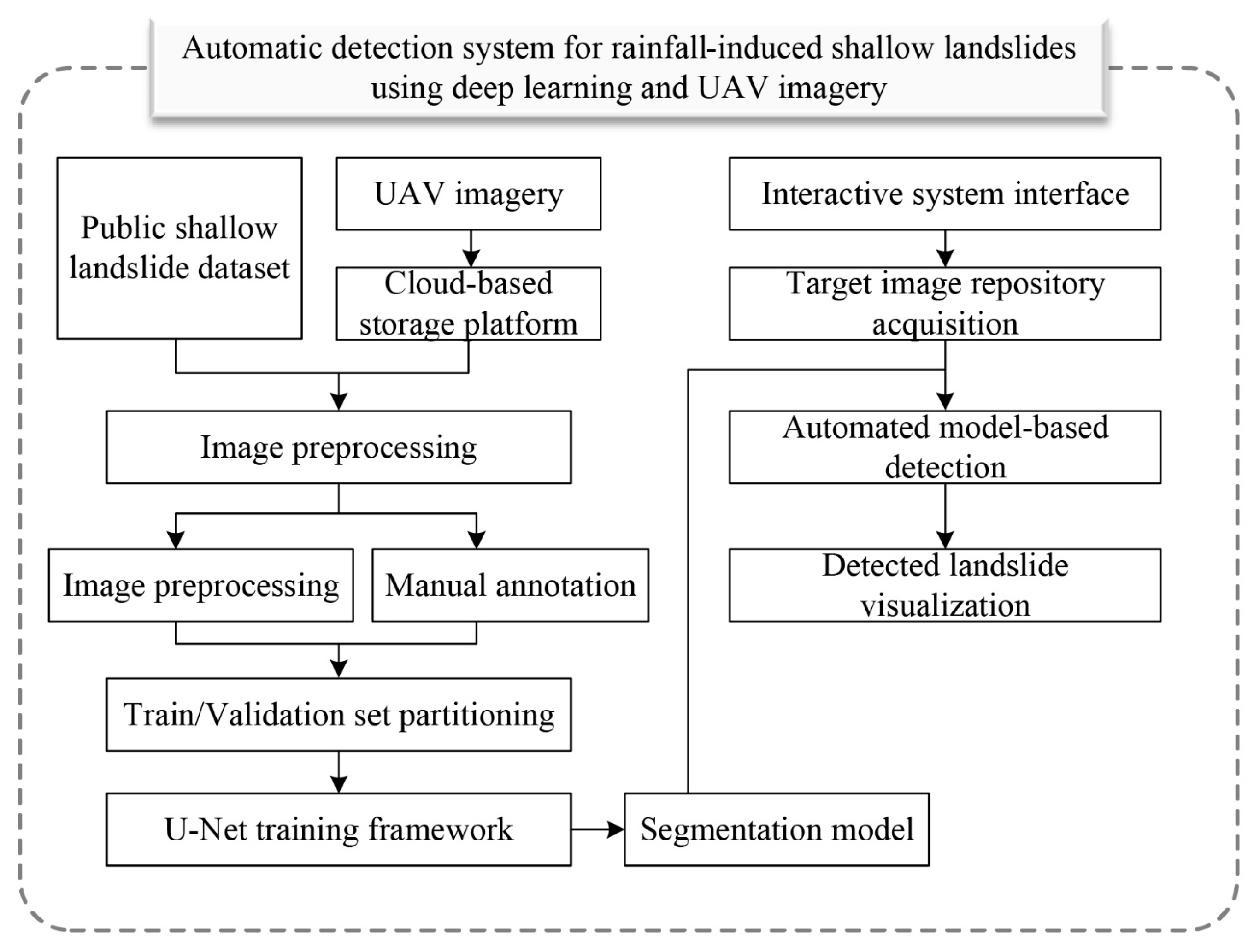
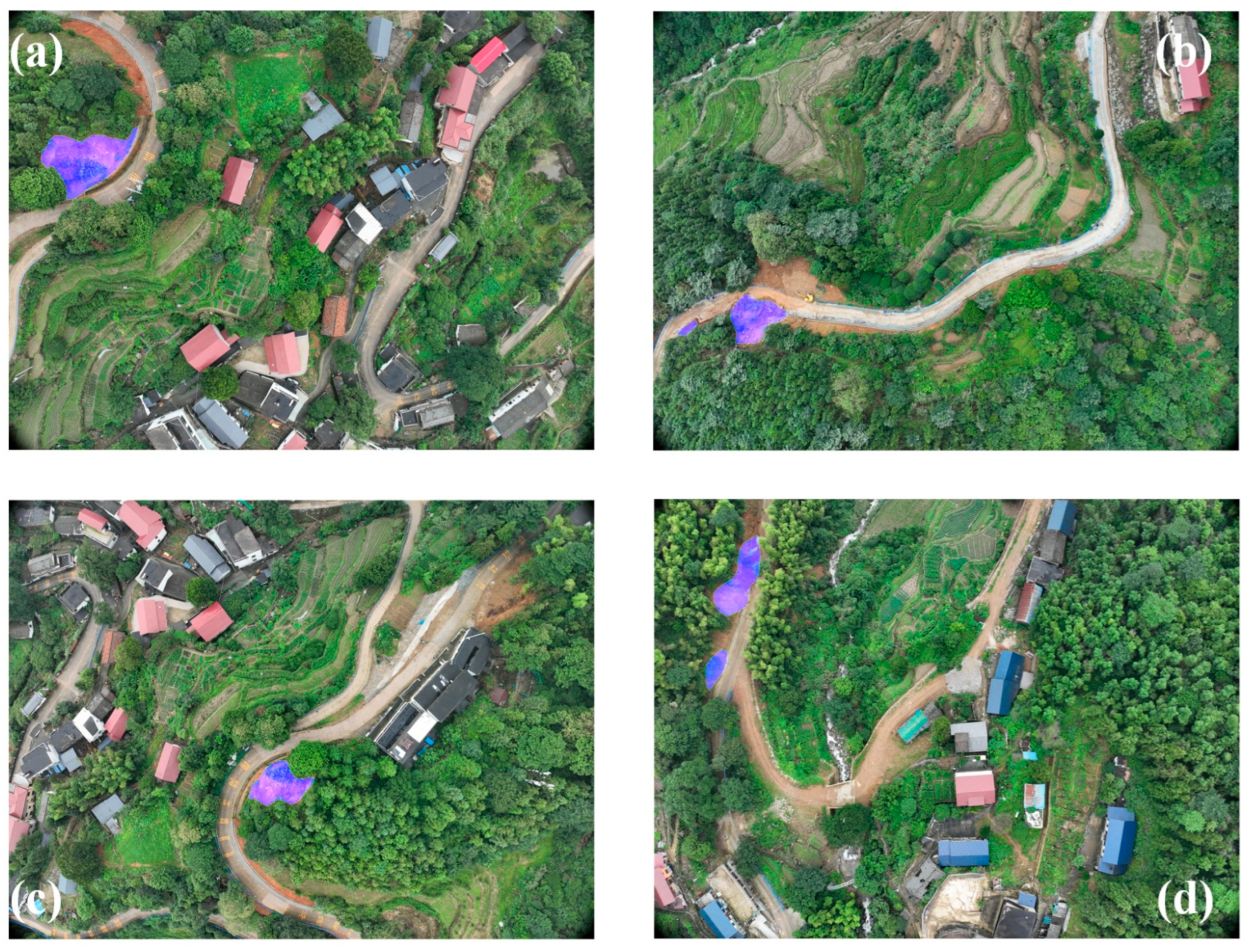
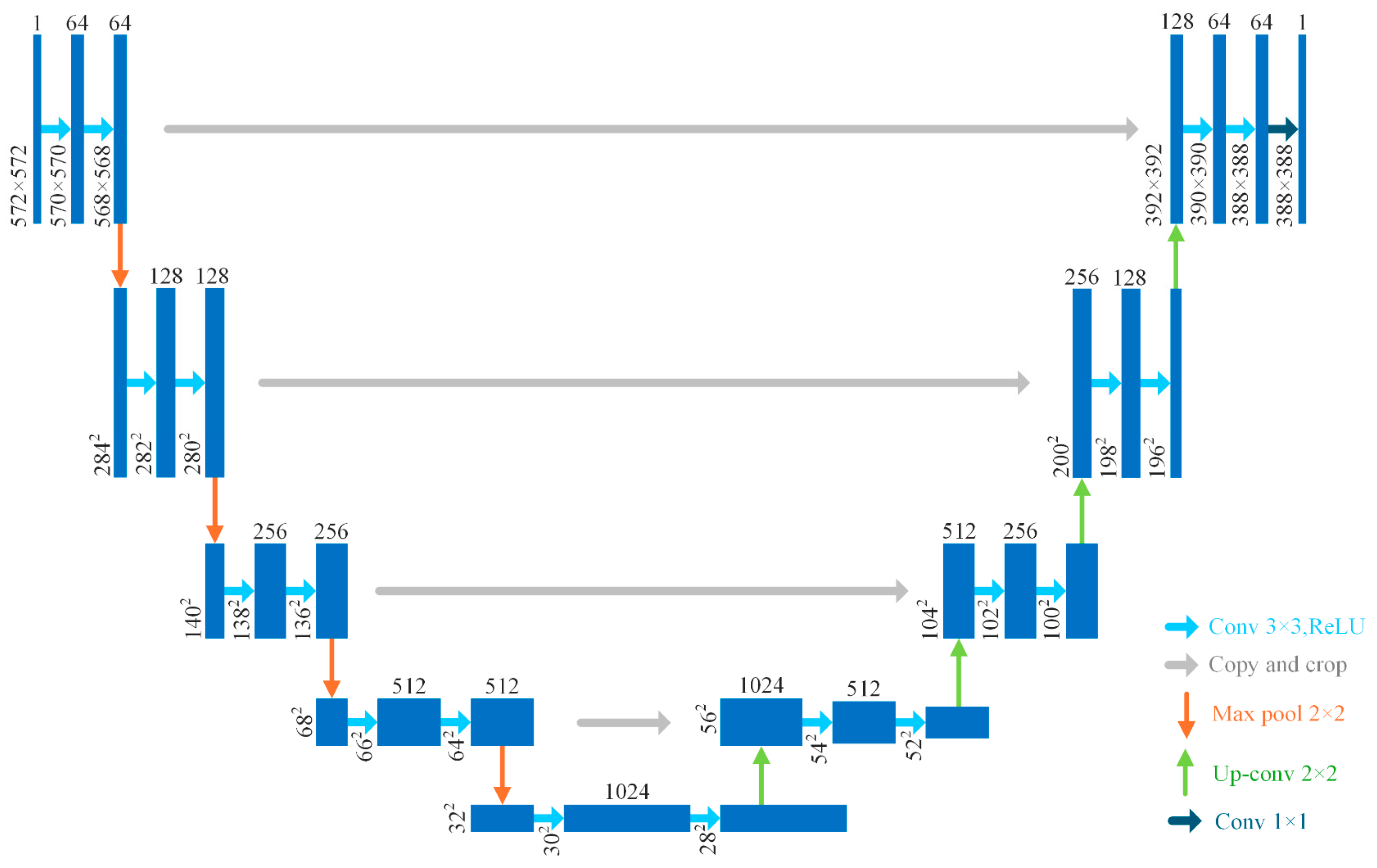
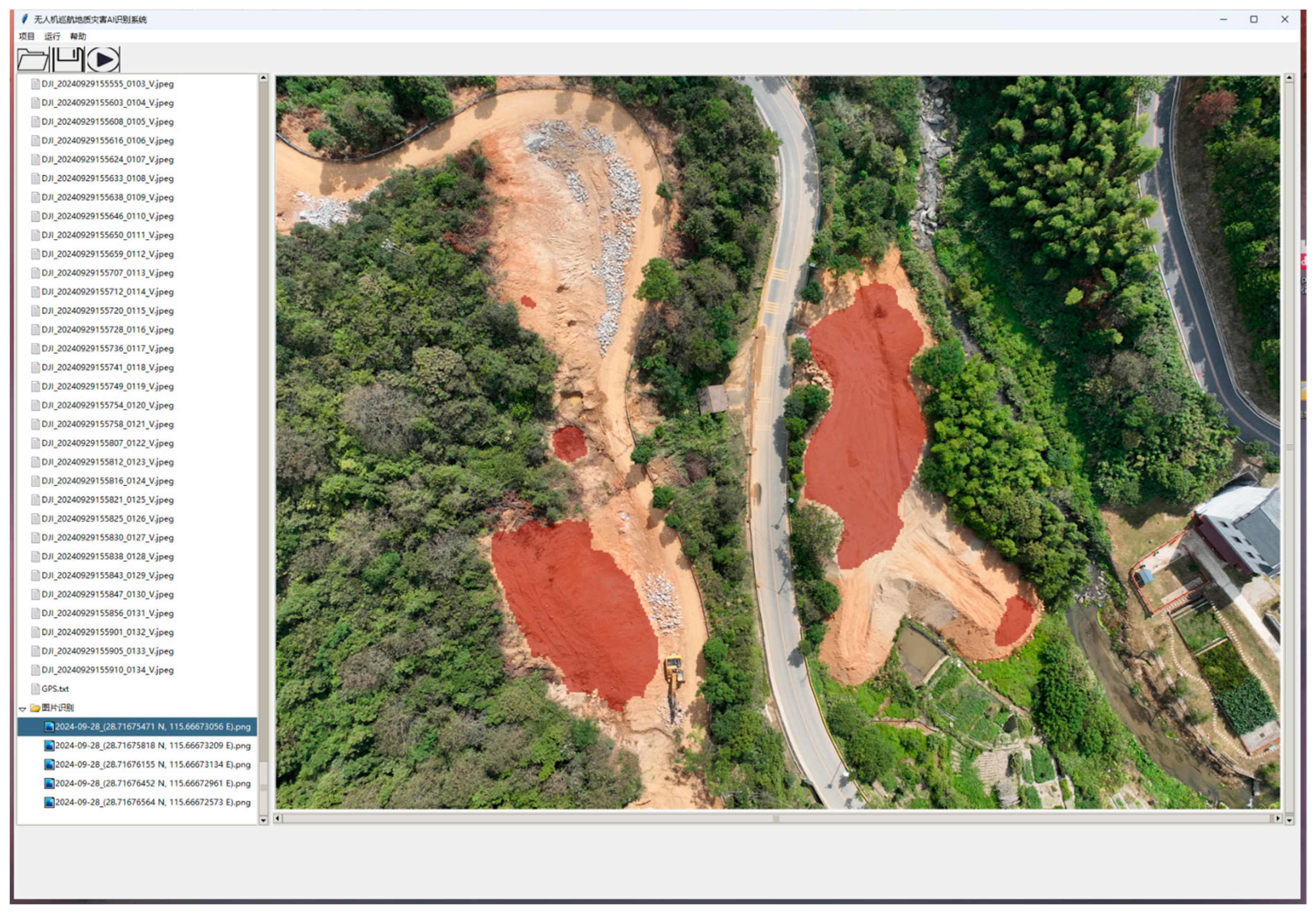

Disclaimer/Publisher’s Note: The statements, opinions and data contained in all publications are solely those of the individual author(s) and contributor(s) and not of MDPI and/or the editor(s). MDPI and/or the editor(s) disclaim responsibility for any injury to people or property resulting from any ideas, methods, instructions or products referred to in the content. |
© 2025 by the authors. Licensee MDPI, Basel, Switzerland. This article is an open access article distributed under the terms and conditions of the Creative Commons Attribution (CC BY) license (https://creativecommons.org/licenses/by/4.0/).
Share and Cite
Zhu, Y.; Xia, B.; Huang, J.; Zhou, Y.; Su, Y.; Gao, H. Automatic Detection System for Rainfall-Induced Shallow Landslides in Southeastern China Using Deep Learning and Unmanned Aerial Vehicle Imagery. Water 2025, 17, 2349. https://doi.org/10.3390/w17152349
Zhu Y, Xia B, Huang J, Zhou Y, Su Y, Gao H. Automatic Detection System for Rainfall-Induced Shallow Landslides in Southeastern China Using Deep Learning and Unmanned Aerial Vehicle Imagery. Water. 2025; 17(15):2349. https://doi.org/10.3390/w17152349
Chicago/Turabian StyleZhu, Yunfu, Bing Xia, Jianying Huang, Yuxuan Zhou, Yujie Su, and Hong Gao. 2025. "Automatic Detection System for Rainfall-Induced Shallow Landslides in Southeastern China Using Deep Learning and Unmanned Aerial Vehicle Imagery" Water 17, no. 15: 2349. https://doi.org/10.3390/w17152349
APA StyleZhu, Y., Xia, B., Huang, J., Zhou, Y., Su, Y., & Gao, H. (2025). Automatic Detection System for Rainfall-Induced Shallow Landslides in Southeastern China Using Deep Learning and Unmanned Aerial Vehicle Imagery. Water, 17(15), 2349. https://doi.org/10.3390/w17152349


