
Changes in Intra-Annual River Runoff in the Ile and Zhetysu Alatau Mountains Under Climate Change Conditions

 , , , and
Abstract
1. Introduction
2. Materials and Methods
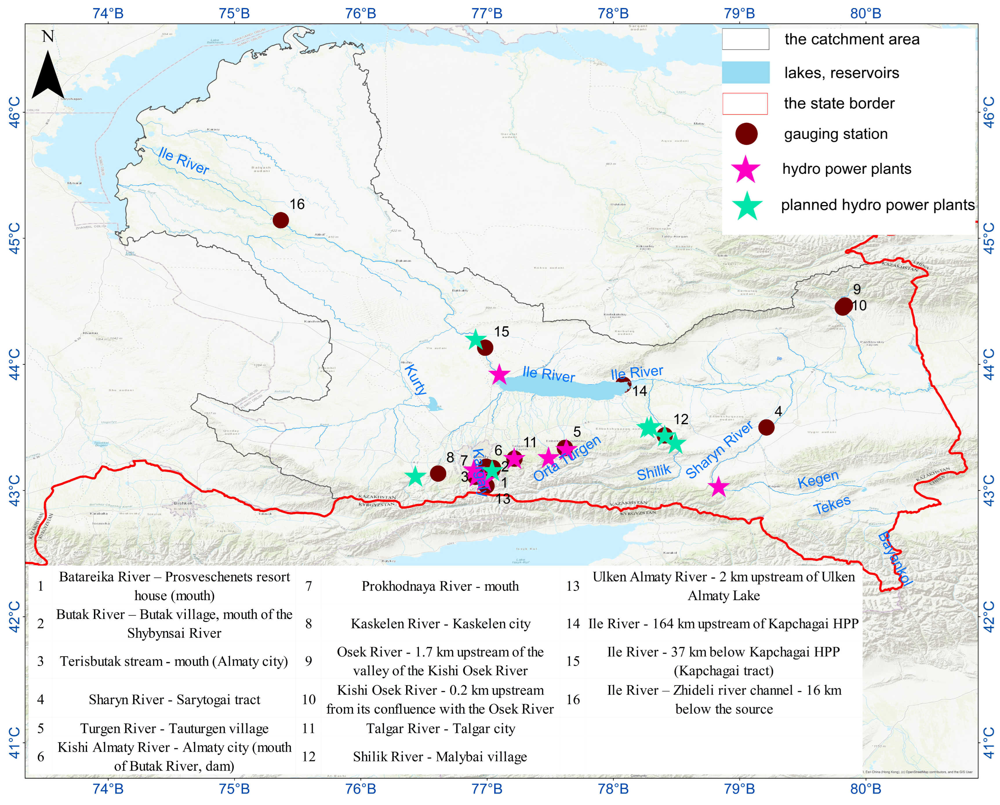
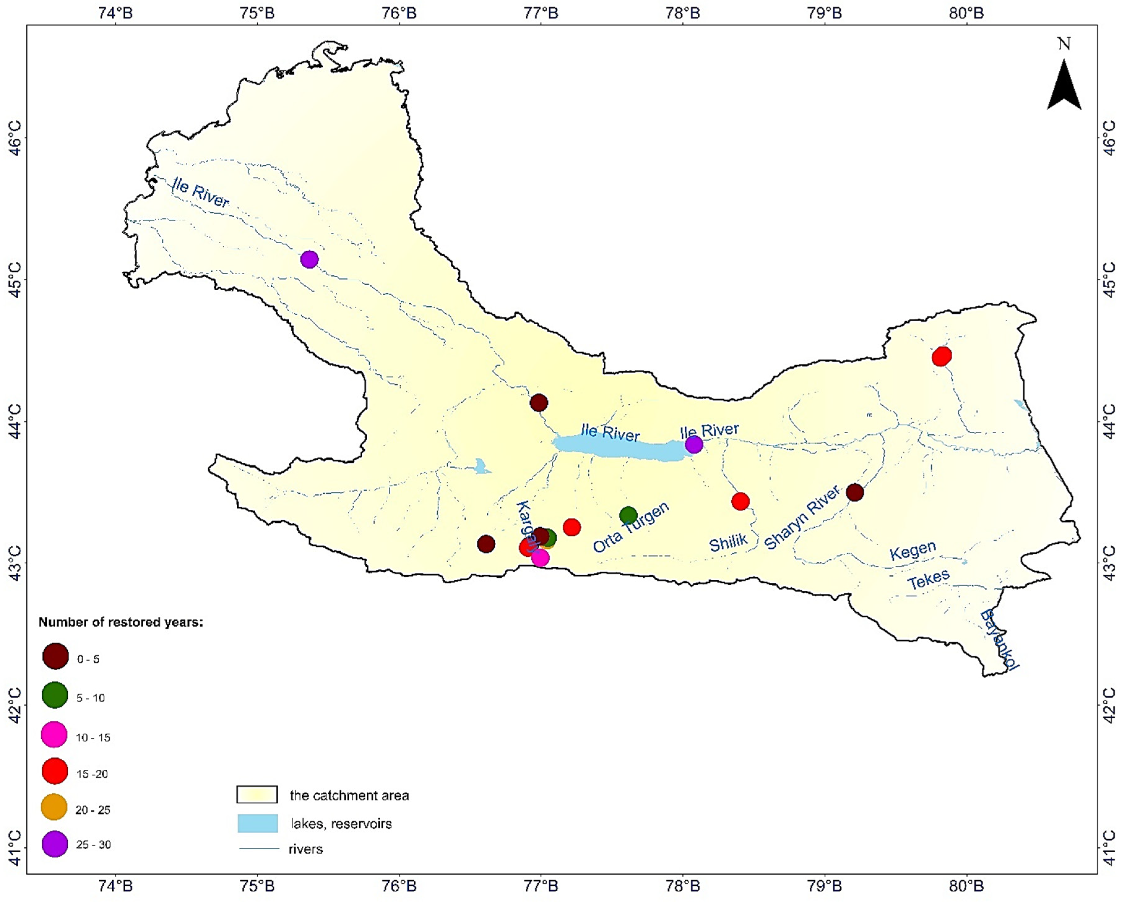
2.1. Observation Data, Research Object, and Prospects for Reservoir Use
2.2. Research Methods
3. Results
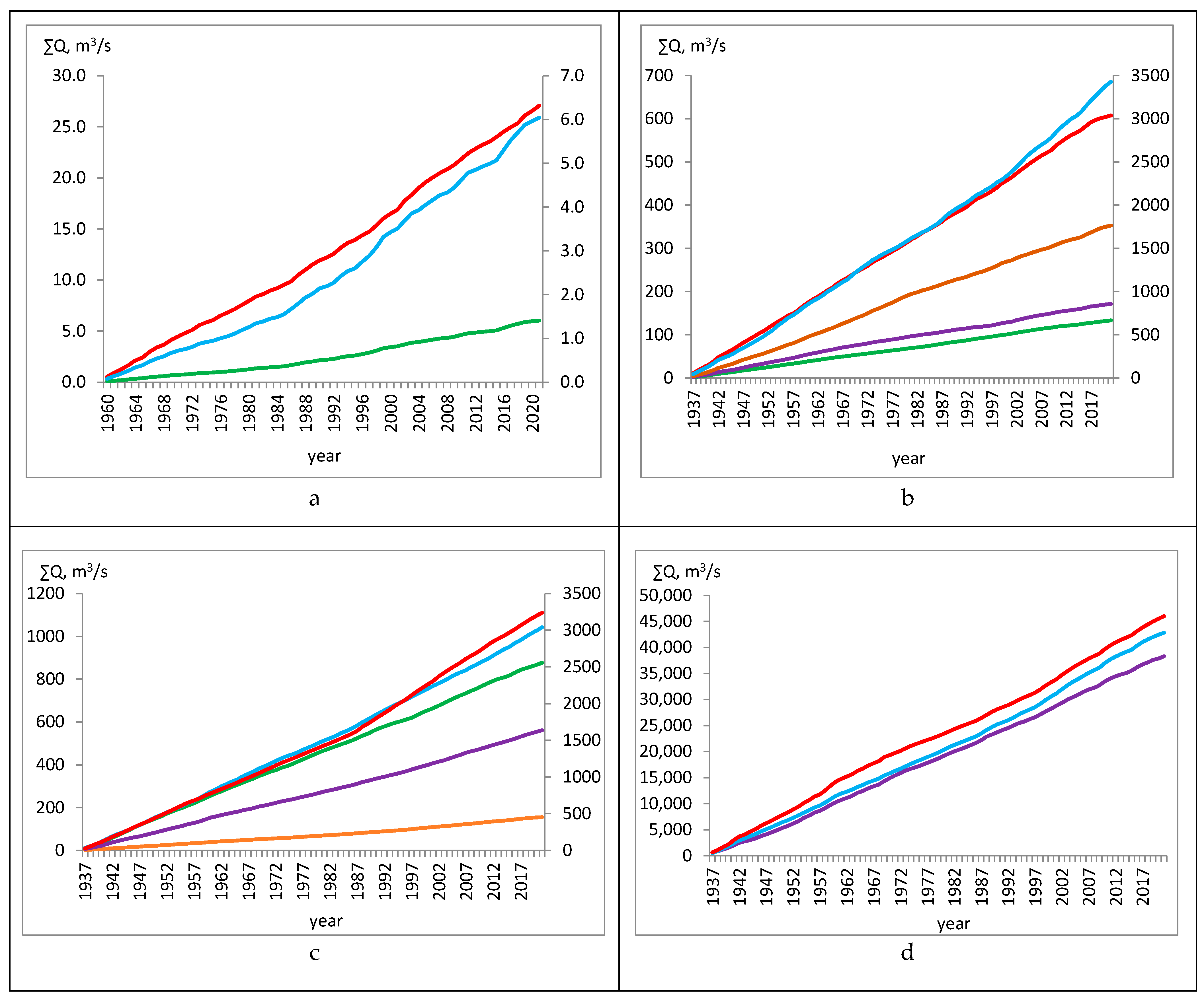
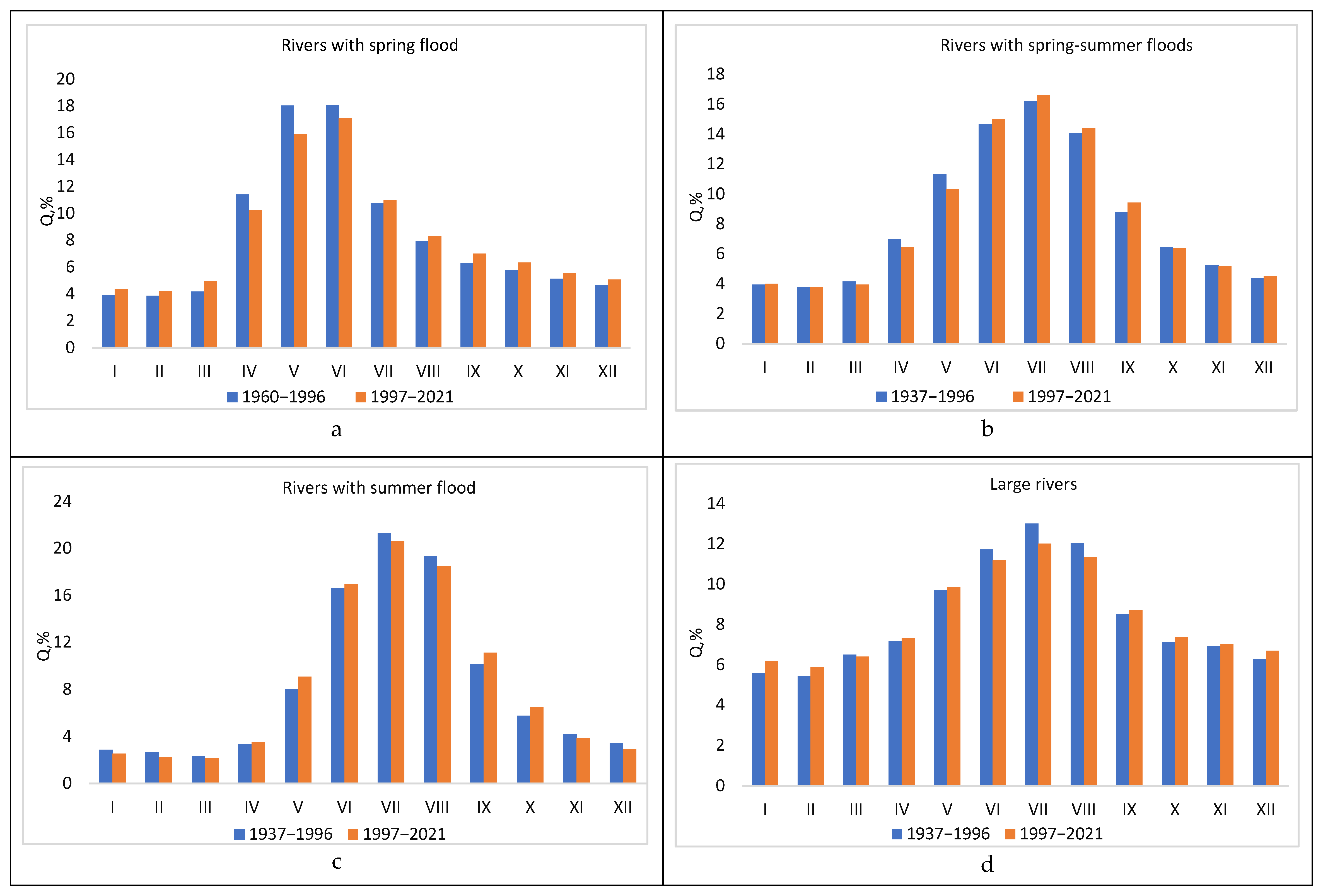
Analysis of Changes in Annual River Runoff Series
4. Discussion
5. Conclusions
- -
- due to global warming, changes in climatic norms of indicators determining the water balance of the Ile River basin entail an increase in the values of annual river runoff for a multi-year period;
- -
- the widespread growth of average annual air temperatures in the basin leads to an increase in high mountain areas with snow reserves, from which the rivers are fed with meltwater;
- -
- the increase in annual precipitation at altitudes up to 2000 m also contributes to the growth of average annual water discharge norms of the basin’s rivers;
- -
- warming, in turn, causes an increase in evaporation, especially in the more arid areas of the basin, such as the semi-desert areas of the lower reaches of the Ile River;
- -
- the complex influence of climate causes noticeable changes in the water regime of the rivers under study, which, depending on the water content and weighted average height of the catchment area, are characterized by different times and periods of flooding;
- -
- the redistribution of intra-annual runoff is generally observed with a large increase in river water content in the cold season;
- -
- in the warm season, the values of the norms of the average monthly water discharge of rivers mainly decrease, and the insignificant growth of monthly runoff norms for this time of the year is observed in the Terisbutak, Butak, and Batareika watercourses.
Author Contributions
Funding
Data Availability Statement
Conflicts of Interest
References
- “General Scheme of Integrated Use and Protection of Water Resources”, Resolution of the Government of the Republic of Kazakhstan dated 8 April 2016 No. 200. Available online: https://adilet.zan.kz/rus/docs/P1600000200 (accessed on 16 July 2025).
- Alimkulov, S.K.; Tursunova, A.A.; Saparova, A.A.; Zagidullina, A.R. Water Resources of the River’s Runoff of Southern Regions of Kazakhstan: Retrospective Condition, Law of Distribution. Mater. In Proceedings of the International Scientific and Practical Conference “Water Resources of Central Asia and Their Use”, posv. Summing Up the Results of the UN Decade “Water for Life”, Almaty, Kazakhstan, 22–24 September 2016; Book 1. pp. 218–226. [Google Scholar]
- Dostai, J.D.; Alimkulov, S.K.; Saparova, A.A. Water Resources of Kazakhstan: Assessment, Forecast, Management. River Flow Resources. Renewable Resources of Surface Waters of the South and South-East of Kazakhstan; Almaty, Kazakhstan, 2012; book 2; Volume 7, 360p. [Google Scholar]
- Consolidated Temirzhanov, M.B.; Alpamyshov, A.Z.; Abdrakhmanov, A.R.; Duisenov, S.M.; Mukasheva, M.M.; Karakozhaev, N.S.; Abisheva, S.M.; Domanova, G.I.; Bekmukashev, K.A.; Kereeva, Z.M.; et al. Analytical Report on the State and Use of Lands of the Republic of Kazakhstan for 2022; Ministry of Agriculture of the Republic of Kazakhstan Committee on Land Resources Management: Astana, Kazakhstan, 2022. Available online: https://www.gov.kz/memleket/entities/land/documents (accessed on 16 July 2025).
- Bazarbayeva, T.A.; Mukanova, G.A.; Oshakbay, A.A. Assessment of the reclamation status of soils in the Akdala irrigation massif. J. Geogr. Environ. Manag. 2020, 56, 52–63. [Google Scholar] [CrossRef]
- Ibrayeva, M.A.; Otarov, A.; Beisenova, G.; Suleimenova, A.; Poshanov, M. Current level of soil fertility of tasmurun part in akdala irrigation array. Soil Sci. Agrichemistry 2016, 1, 24–36. (In Russian) [Google Scholar]
- Nysanbayev, Y.N.; Medeu, A.R.; Tursunova, A.A. Water Problems of Central Asia. Issues Geogr. Geoecology 2016. [Google Scholar]
- Concept of Development of Water Resources Management System of the Republic of Kazakhstan for 2024–2030, Resolution of the Government of the Republic of Kazakhstan dated 5 February 2024 No. 66. Available online: https://adilet.zan.kz/rus/docs (accessed on 16 July 2025).
- General Plan of Alatau City of Almaty Region, Resolution of the Government of the Republic of Kazakhstan dated 17 May 2024 No. 388. Available online: https://adilet.zan.kz/rus/docs (accessed on 16 July 2025).
- Alimkulov, S.N.; Myrzakhmetov, A.N. Hydrographic network of the republic of kazakhstan. Izdenister Natigeler 2023, 4, 247–257. [Google Scholar] [CrossRef]
- Annual Data on the Regime and Resources of Surface Waters of the Land. Available online: https://www.kazhydromet.kz (accessed on 16 July 2025).
- Bureau of National Statistics of the Agency for Strategic Planning and Reforms of the Republic of Kazakhstan. Available online: https://stat.gov.kz/ (accessed on 16 July 2025).
- Hydropower Sector Development Plan of the Republic of Kazakhstan for 2020–2030. Available online: https://www.gov.kz/memleket/entities/energo/documents/details (accessed on 16 July 2025).
- State Water Cadastre of the Republic of Kazakhstan. Long-Term Data on the Regime and Resources of Surface Waters of the Land, 1981–1990; Lake Balkhash Basin and Drainless Areas of Central Kazakhstan; State Water Cadastre of the Republic of Kazakhstan: Almaty, Kazakhstan, 2002; Book 2, Issue 1, Part 1; p. 284. [Google Scholar]
- State Water Cadastre of the Republic of Kazakhstan. State Water Cadastre of the Republic of Kazakhstan. In Long-Term Data on the Regime and Resources of Surface Waters of the Land, 1991–1990; Lake Balkhash Basin and Drainless Areas of Central Kazakhstan; State Water Cadastre of the Republic of Kazakhstan: Almaty, Kazakhstan, 2004; Book 1, Issue 1, Part 1; p. 171. [Google Scholar]
- Long-Term Data on the Regime and Resources of Surface Waters of the Land. River Basins of Lake Balkhash and Drainless Areas of Central Kazakhstan; Kazhydromet: Almaty, Kazakhstan, 2006; Volume 4, pp. 17–285. Available online: https://www.kazhydromet.kz/en/gidrologiya/gosudarstvennyy-vodnyy-kadastr-poverhnostnye-vody (accessed on 16 July 2025).
- SP-33-101-2003; Definition of the Basic Design Characteristics. Gosstroy of Russia: Moscow, Russia, 2004; p. 71.
- Davletgaliev, S.K. Statistical Methods of Processing Hydrological Information; Publishing House of KazNU Named After Al-Farabi “Kazakh University”: Almaty, Kazakhstan, 2015; ISBN 987-601-04-1341-217. [Google Scholar]
- Vladidmirov, A.M. Hydrological Calculations; Gidrometeoizdat: Leningrad, Russia, 1980; pp. 105–110. [Google Scholar]
- Hua, L.; Zhao, T.; Zhong, L. Future Changes in Drought over Central Asia under CMIP6 Forcing Scenarios. J. Hydrol. Reg. Stud. 2022, 43, 10119. [Google Scholar] [CrossRef]
- Ma, Q.; Zhang, J.; Game, A.T.; Chang, Y.; Li, S. Spatiotemporal Variability of Summer Precipitation and Precipitation Extremes and Associated Large-Scale Mechanisms in Central Asia during 1979–2018. J. Hydrol. X 2020, 8, 100061. [Google Scholar] [CrossRef]
- Salnikov, V.; Talanov, Y.; Polyakova, S.; Assylbekova, A.; Kauazov, A.; Bultekov, N.; Musralinova, G.; Kissebayev, D.; Beldeubayev, Y. An Assessment of the Present Trends in Temperature and Precipitation Extremes in Kazakhstan. Climate 2023, 11, 33. [Google Scholar] [CrossRef]
- Makhmudova, L.; Kozykeyeva, A.; Kambarbekov, G.; Karimova, G.; Zhulkainarova, M. Hydrological bases of water resources management of the rivers of Northern Kazakhstan. J. Contam. Hydrol. 2023, 256, 104182. [Google Scholar] [CrossRef] [PubMed]
- Talipova, E.; Shrestha, S.; Alimkulov, S.; Nyssanbayeva, A.; Tursunova, A.; Isakan, G. Influence of Climate Change and Anthropogenic Factors on the Ile River Basin Streamflow, Kazakhstan. Arab. J. Geosci. 2021, 14, 1756. [Google Scholar] [CrossRef]
- Duskayev, K.; Mussina, A.; Rodrigo-Ilarri, J.; Zhanabayeva, Z.; Tursyngali, M.; Rodrigo-Clavero, M.-E. Study of temporal changes in the hydrographic network of small mountain rivers in the Ile Alatau, Kazakhstan. Hydrol. Res. 2023, 54, 1420–1431. [Google Scholar] [CrossRef]
- Galperin, R.I. Long-Term Fluctuations of Annual River Flow in the Balkhash Lake Basin; Geographical Problems of the Ile-Balkhash Basin; Gylim Publishing House: Almaty, Kazakhstan, 1993; pp. 63–70. [Google Scholar]
- Kozhakhmetov, P.Z.; Monkayeva, G.Y. Estimation of Evaporation from Water Surface on the Basis of Actual Data of Measurements with the help of GGI-3000 (on the Example of Ile-Balkash Basin). Hydrometeorol. Ecol. 2017. [Google Scholar]
- Abdrahimov, R.G.; Amirgaliyeva, A.S.; Dauletiyarov, K.B.; Ziyarov, A.M. Current trends in the annual flow of the Ile (Ili) River and its large tributaries under climate warming. Vestn. Mosk. Univ. Seriya 5 Geografiya 2021, 4, 83–90. [Google Scholar]
- Abdrakhimov, R.G.; Akzharkynova, A.N.; Rodrigo-Ilarri, J.; Nahiduzzaman, K.M.; Dautaliyeva, M.E.; Rodrigo-Clavero, M.-E. Assessment of Changes in Hydrometeorological Indicators and Intra-Annual River Runoff in the Ile River Basin. Water 2024, 16, 1921. [Google Scholar] [CrossRef]
- Annual Bulletin of Monitoring the State and Climate Change in Kazakhstan. Kazhydromet, Astana, Republic of Kazakhstan. Available online: https://www.kazhydromet.kz/ru/klimat/ezhegodnyy-byulleten-monitoringa-sostoyaniya-i-izmeneniya-klimata-kazahstana (accessed on 16 July 2025).
- Surface Water Resources of the USSR. Central and Southern Kazakhstan. Lake Balkhash Basin; Candidate of Geographical Sciences, Semenov, V.A., Kurdin, R.D., Eds.; Hydrometeorological Publishing House: Leningrad, Russia, 1970; Volume 13, 114p. [Google Scholar]
- Makhmudova, L.; Beisembin, K.; Moldakhmetov, M.; Mussina, A.; Kanatuly, A. Intra-Annual Flow Distribution of the Rivers in the Yesil River Basin. Water Conserv. Manag. 2024, 8, 241–250. [Google Scholar] [CrossRef]
- Rozhdestvensky, A.V.; Chebotarev, A.I. Statistical Methods in Hydrology; Gidromet Publishing: Leningrad, Russia, 1974; p. 424. [Google Scholar]
- Alimkulov, S.; Dostay, Z.; Myrzakhmetov, A. The Role of Climate Change in the Water Regime of Rivers in South-East of Kazakhstan. Int. J. Adv. Res. Sci. Eng. Technol. 2017, 4, 4748–4760. [Google Scholar]
- Water Resources of Kazakhstan: Assessment, Forecast, Management: In the 21st Volume of the Monograph; Snow and Ice Resources of Kazakhstan, Seversky, I.V., Kokarev, A.L., Pimankina, N.V., Eds.; B. I.: Almaty, Kazakhstan, 2012; Volume 6, 246p. [Google Scholar]
- Chigrinets, A.G.; Duskaev, K.K.; Satmurzayev, A.A.; Insigenova, A.E.; Salavatova, Z.T. Study of the Main Characteristics and Intra-Annual Distribution of Water Flow of Rivers of the Territory of Almaty. Hydrometeorol. Ecol. 2021, 3, 44–62. [Google Scholar] [CrossRef]


| River Point | Season | ||
|---|---|---|---|
| Rivers with spring flood | |||
| Butak River—Butak village | spring–summer III–VI | summer–autumn VII–XI | winter XII–II |
| Big (Ulken) Almaty—Terisbutak | |||
| Batareika River—Prosveschenets resort house | |||
| Rivers with spring–summer floods | |||
| Sharyn River—Sarytogai tract | spring–summer III–IX | autumn X, XI | winter XII–II |
| Turgen River—Turgen village | |||
| Kaskelen River—Kaskelen city | |||
| Small (Kishi) Almaty River—Almaty city | |||
| Prokhodnaya River—mouth | |||
| Rivers with summer floods | |||
| Usek River—1.7 km upstream of the valley of the Kishi Usek River | summer V–IX | autumn–winter X–II | spring III, IV |
| Kishi Usek River—0.2 km upstream from its confluence with the Usek River | |||
| Yesik River-Yesik city | |||
| Big (Ulken) Almaty—upstream of Big Almaty Lake | |||
| Talgar River—Talgar city | |||
| Shelek River—Malybai village | |||
| Rivers with spring–summer floods | |||
| Ile River—Kapchagai tract | spring II–VI | autumn–winter X–I | summer VII–IX |
| Ile River—164 km upstram of Kapchagai | |||
| Ile River—Zhideli river channel | |||
| Gauging Station | Periods | Rivers with Spring Flood (Q, m3/s) | |||||||||||||||||||||||
|---|---|---|---|---|---|---|---|---|---|---|---|---|---|---|---|---|---|---|---|---|---|---|---|---|---|
| I | Change in % | II | Change in % | III | Change in % | IV | Change in % | V | Change in % | VI | Change in % | VII | Change in % | VIII | Change in % | IX | Change in % | X | Change in % | XI | Change in % | XII | Change in % | ||
| Butak River—Butak village, mouth of the Shybynsai River | 1960–1996 | 0.11 | 22 | 0.11 | 21 | 0.12 | 28 | 0.31 | 6 | 0.46 | 3 | 0.4 | 7 | 0.27 | 8 | 0.2 | 20 | 0.17 | 21 | 0.15 | 22 | 0.14 | 20 | 0.12 | 24 |
| 1997–2021 | 0.14 | 0.14 | 0.17 | 0.33 | 0.48 | 0.43 | 0.29 | 0.25 | 0.22 | 0.19 | 0.17 | 0.16 | |||||||||||||
| Terisbutak stream—river mouth (Almaty city) | 1960–1996 | 0.19 | 35 | 0.18 | 37 | 0.21 | 35 | 0.40 | 25 | 0.79 | 7 | 0.91 | 8 | 0.54 | 22 | 0.38 | 25 | 0.31 | 30 | 0.28 | 35 | 0.25 | 33 | 0.22 | 36 |
| 1997–2021 | 0.30 | 0.29 | 0.31 | 0.53 | 0.85 | 0.99 | 0.69 | 0.50 | 0.45 | 0.42 | 0.38 | 0.34 | |||||||||||||
| Batareika River—Prosveschenets resort house (river mouth) | 1960–1996 | 0.03 | 41 | 0.03 | 37 | 0.03 | 53 | 0.12 | 29 | 0.17 | 38 | 0.17 | 46 | 0.09 | 49 | 0.07 | 45 | 0.05 | 48 | 0.05 | 41 | 0.04 | 44 | 0.04 | 39 |
| 1997–2021 | 0.05 | 0.05 | 0.06 | 0.17 | 0.27 | 0.32 | 0.18 | 0.13 | 0.10 | 0.08 | 0.07 | 0.07 | |||||||||||||
| Average | 33 | 32 | 38 | 20 | 16 | 20 | 26 | 30 | 33 | 32 | 32 | 33 | |||||||||||||
| Rivers with spring and summer floods (Q, m3/s) | |||||||||||||||||||||||||
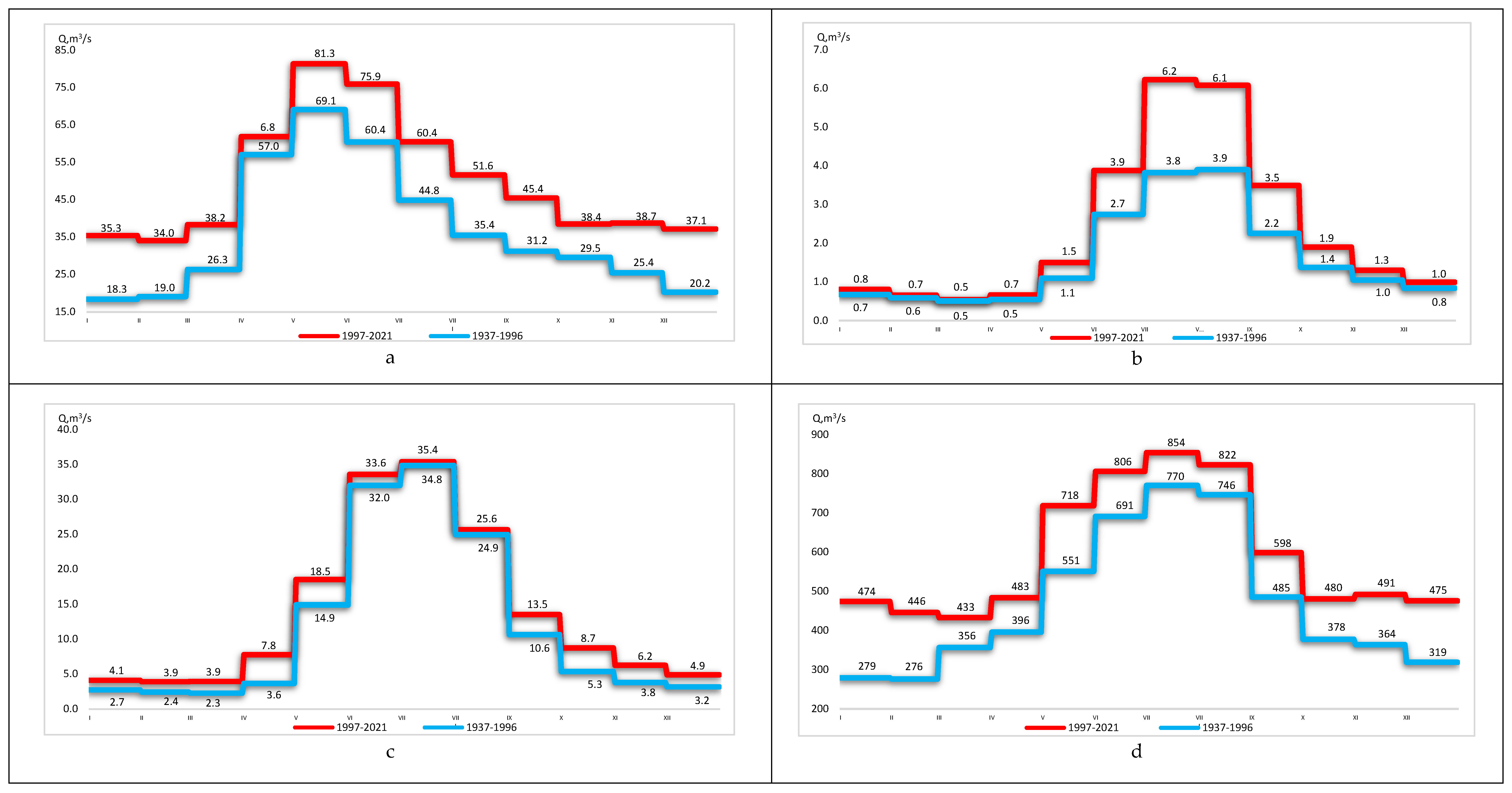
| Sharyn River—Sarytogai tract | 1937–1996 | 18.3 | 93 | 19.0 | 79 | 26.3 | 46 | 57.0 | 8 | 69.1 | 18 | 60.4 | 26 | 44.8 | 35 | 35.4 | 45 | 31.2 | 46 | 29.5 | 30 | 25.4 | 52 | 20.2 | 84 |
| 1997–2021 | 35.3 | 34.0 | 38.2 | 61.8 | 81.3 | 75.9 | 60.4 | 51.6 | 45.4 | 38.4 | 38.7 | 37.1 | |||||||||||||
| Turgen River—Tauturgen village | 1937–1996 | 2.8 | −7 | 2.6 | −4 | 2.6 | −8 | 5.2 | −2 | 10.7 | −9 | 13.7 | 9 | 15.4 | 9 | 13.3 | 5 | 7.0 | 20 | 4.7 | 15 | 3.7 | 11 | 3.1 | −3 |
| 1997–2021 | 2.6 | 2.5 | 2.4 | 5.1 | 9.7 | 14.9 | 16.8 | 14.0 | 8.4 | 5.4 | 4.1 | 3.0 | |||||||||||||
| Kaskelen River—Kaskelen city | 1937–1996 | 1.90 | 1 | 1.78 | 2 | 1.82 | 2 | 2.33 | −4 | 4.19 | −10 | 7.23 | 9 | 9.68 | 1 | 8.35 | −6 | 4.75 | 0 | 3.19 | −2 | 2.55 | −5 | 2.20 | −3 |
| 1997–2021 | 1.93 | 1.82 | 1.86 | 2.23 | 3.79 | 7.91 | 9.78 | 7.85 | 4.75 | 3.11 | 2.41 | 2.14 | |||||||||||||
| Kishi Almaty River—Almaty city (mouth of Butakovka River, dam) | 1937–1996 | 1.04 | −28 | 0.95 | −25 | 0.99 | −18 | 1.51 | 1 | 2.65 | −2 | 3.35 | 4 | 3.79 | 6 | 3.51 | 3 | 2.21 | 14 | 1.54 | −2 | 1.32 | −16 | 1.13 | −19 |
| 1997–2021 | 0.75 | 0.72 | 0.81 | 1.53 | 2.58 | 3.50 | 4.00 | 3.62 | 2.52 | 1.51 | 1.10 | 0.92 | |||||||||||||
| Prokhodnaya River—river mouth | 1937–1996 | 0.78 | 2 | 0.73 | 0 | 0.74 | −9 | 0.88 | −9 | 1.66 | −6 | 2.83 | −4 | 3.30 | 0 | 2.92 | 2 | 1.89 | −4 | 1.33 | −2 | 1.03 | 2 | 0.88 | 2 |
| 1997–2021 | 0.79 | 0.73 | 0.67 | 0.81 | 1.57 | 2.73 | 3.29 | 2.99 | 1.80 | 1.30 | 1.05 | 0.90 | |||||||||||||
| Average | −8 | −8 | −8 | −4 | −6 | 3 | 2 | 0 | 3 | −2 | −7 | −7 | |||||||||||||
| Gauging station | Periods | Rivers with summer flood (Q, m3/s) | |||||||||||||||||||||||
| I | Change in % | II | Change in % | III | Change in % | IV | Change in % | V | Change in % | VI | Change in % | VII | Change in % | VIII | Change in % | IX | Change in % | X | Change in % | XI | Change in % | XII | Change in % | ||
| Usek River—1.7 km upstream of the valley of the Kishi Usek River | 1937–1996 | 2.7 | 50 | 2.4 | 62 | 2.3 | 73 | 3.6 | 113 | 14.9 | 24 | 32.0 | 5 | 34.8 | 2 | 24.9 | 3 | 10.6 | 27 | 5.3 | 63 | 3.8 | 65 | 3.2 | 54 |
| 1997–2021 | 4.1 | 3.9 | 3.9 | 7.8 | 18.5 | 33.6 | 35.4 | 25.6 | 13.5 | 8.7 | 6.2 | 4.9 | |||||||||||||
| Kishi Usek River—0.2 km upstream from its confluence with the Usek River | 1937–1996 | 2.2 | 35 | 1.9 | 35 | 1.8 | 34 | 2.2 | 53 | 5.9 | 46 | 13.7 | 28 | 17.1 | 17 | 13.5 | 17 | 6.8 | 32 | 4.1 | 73 | 3.1 | 30 | 2.5 | 36 |
| 1997–2021 | 2.9 | 2.6 | 2.4 | 3.4 | 8.6 | 17.5 | 20.0 | 15.7 | 9.0 | 7.2 | 4.0 | 3.4 | |||||||||||||
| Ulken Almaty River—2 km upstream of Big Almaty Lake | 1937–1996 | 0.7 | 19 | 0.6 | 11 | 0.5 | 5 | 0.5 | 22 | 1.1 | 37 | 2.7 | 41 | 3.8 | 63 | 3.9 | 56 | 2.2 | 55 | 1.4 | 38 | 1.0 | 24 | 0.8 | 19 |
| 1997–2021 | 0.8 | 0.7 | 0.5 | 0.7 | 1.5 | 3.9 | 6.2 | 6.1 | 3.5 | 1.9 | 1.3 | 1.0 | |||||||||||||
| Talgar River—Talgar city | 1937–1996 | 4.3 | 13 | 4.0 | 15 | 3.8 | 13 | 4.5 | 6 | 8.2 | 22 | 15.5 | 19 | 23.3 | −3 | 25.3 | −9 | 14.2 | 5 | 8.1 | 13 | 6.1 | 5 | 5.0 | 6 |
| 1997–2021 | 4.9 | 4.6 | 4.3 | 4.7 | 10.0 | 18.5 | 22.6 | 22.9 | 14.9 | 9.1 | 6.4 | 5.3 | |||||||||||||
| Shelek River—Malybai village | 1937–1996 | 10.8 | −79 | 11 | −77 | 10.3 | −56 | 19.3 | −6 | 38.9 | 81 | 61.1 | 69 | 80.9 | 50 | 82 | 47 | 45.5 | 76 | 23.5 | 39 | 16 | −41 | 12 | −83 |
| 1997–2021 | 2.3 | 2.48 | 4.58 | 18.2 | 70.5 | 103 | 122 | 121 | 80 | 32.7 | 9.4 | 2 | |||||||||||||
| Average | −15 | −17 | −12 | 7 | 47 | 43 | 37 | 31 | 45 | 30 | −4 | −19 | |||||||||||||
| Rivers with spring and summer floods (Q, m3/s) | |||||||||||||||||||||||||
| Ile River—164 km upstream of Kapchagai HPP | 1937–1996 | 219 | 35 | 225 | 33 | 346 | 12 | 353 | 19 | 474 | 19 | 703 | −5 | 868 | −16 | 727 | −8 | 395 | 24 | 327 | 32 | 326 | 22 | 277 | 25 |
| 1997–2021 | 296 | 299 | 390 | 421 | 563 | 666 | 726 | 671 | 489 | 433 | 397 | 347 | |||||||||||||
| Ile River—37 km below Kapchagai HPP (Kapchagai tract) | 1937–1996 | 279 | 70 | 276 | 61 | 356 | 22 | 396 | 22 | 551 | 30 | 691 | 17 | 770 | 11 | 746 | 10 | 485 | 23 | 378 | 27 | 364 | 35 | 319 | 49 |
| 1997–2021 | 474 | 446 | 433 | 483 | 718 | 806 | 854 | 822 | 598 | 480 | 491 | 475 | |||||||||||||
| Ile River—Zhideli river channel, 16 km below the source | 1937–1996 | 416 | 24 | 398 | 18 | 413 | 18 | 481 | 24 | 589 | 26 | 606 | 33 | 609 | 42 | 591 | 38 | 579 | 20 | 519 | 14 | 496 | 12 | 464 | 20 |
| 1997–2021 | 514 | 472 | 487 | 596 | 740 | 804 | 863 | 815 | 693 | 591 | 553 | 558 | |||||||||||||
| Average | 43 | 37 | 17 | 22 | 25 | 15 | 12 | 13 | 22 | 24 | 23 | 31 | |||||||||||||
| Gauging station | Rivers with spring flood | |||||||||||||||
| W, km3 | Winter XII–II | Spring–Summer III–VI | Summer–Autumn VII–XI | |||||||||||||
| 1960–1996 | 1997–2021 | Change in km3 | Change in % | 1960–1996 | 1997–2021 | Change in km3 | Change in % | 1960–1996 | 1997–2021 | Change in km3 | Change in % | 1960–1996 | 1997–2021 | Change in km3 | Change in % | |
| 1 | 2 | 3 | 4 | 5 | 14 | 15 | 16 | 17 | 6 | 7 | 8 | 9 | 10 | 11 | 12 | 13 |
| Butak River—Butak village, moutn of the Shybynsai River | 0.007 | 0.008 | 0.001 | 19 | 0.003 | 0.005 | 0.001 | 36 | 0.010 | 0.01 | 0.0009 | 9 | 0.006 | 0.007 | 0.001 | 21 |
| Terisbutak stream—river mouth (Almaty city) | 0.013 | 0.016 | 0.003 | 28 | 0.006 | 0.009 | 0.003 | 50 | 0.018 | 0.02 | 0.0028 | 16 | 0.011 | 0.015 | 0.004 | 40 |
| Batareika River—Prosveschenets resort house (river mouth) | 0.002 | 0.004 | 0.002 | 86 | 0.001 | 0.002 | 0.001 | 100 | 0.004 | 0.01 | 0.0028 | 75 | 0.002 | 0.003 | 0.002 | 83 |
| Average | 0.002 | 44 | 0.002 | 62 | 0.002 | 33 | 0.002 | 48 | ||||||||
| Gauging station | Rivers with spring and summer floods | |||||||||||||||
| W, km3 | Winter XII–II | Spring–Summer III–IX | Autumn X, XI | |||||||||||||
| 1937–1996 | 1997–2021 | Change in km3 | Change in % | 1937–1996 | 1997–2021 | Change in km3 | Change in % | 1937–1996 | 1997–2021 | Change in km3 | Change in % | 1937–1996 | 1997–2021 | Change in km3 | Change in % | |
| 1 | 2 | 3 | 4 | 5 | 14 | 15 | 16 | 17 | 6 | 7 | 8 | 9 | 10 | 11 | 12 | 13 |
| Sharyn River—Sarytogai tract | 1.16 | 1.5 | 0.300 | 26 | 0.61 | 1.01 | 0.41 | 67 | 1.5 | 1.7 | 0.28 | 19 | 0.86 | 1.15 | 0.28 | 33 |
| Turgen River—Tauturgen village | 0.22 | 0.2 | 0.013 | 6 | 0.09 | 0.09 | 0.00 | −3 | 0.3 | 0.3 | 0.02 | 5 | 0.13 | 0.15 | 0.02 | 12 |
| Kaskelen River—Kaskelen city | 0.13 | 0.1 | −0.004 | −3 | 0.06 | 0.06 | 0.00 | 0 | 0.2 | 0.2 | 0.00 | 0 | 0.09 | 0.09 | 0.00 | −3 |
| Kishi Almaty River—Almaty city (mouth of Butakovka River, dam) | 0.06 | 0.1 | 0.003 | 6 | 0.03 | 0.03 | −0.01 | −23 | 0.1 | 0.1 | 0.00 | 3 | 0.04 | 0.04 | 0.00 | −7 |
| Prokhodnaya River—river mouth | 0.05 | 0.1 | 0.001 | 3 | 0.03 | 0.03 | 0.00 | 0 | 0.1 | 0.1 | 0.00 | 3 | 0.04 | 0.03 | −0.01 | −33 |
| Average | 0.06 | 7 | 0.08 | 8 | 0.06 | 6 | 0.06 | 0 | ||||||||
| Gauging station | Rivers with summer flood | |||||||||||||||
| W, km3 | Spring III, IV | Summer V–IX | Autumn–Winter X–II | |||||||||||||
| 1937–1996 | 1997–2021 | Change in km3 | Change in % | 1937–1996 | 1997–2021 | Change in km3 | Change in % | 1937–1996 | 1997–2021 | Change in km3 | Change in % | 1937–1996 | 1997–2021 | Change in km3 | Change in % | |
| 1 | 2 | 3 | 4 | 5 | 14 | 15 | 16 | 17 | 6 | 7 | 8 | 9 | 10 | 11 | 12 | 13 |
| Usek River—1.7 km upstream of the valley of the Kishi Usek River | 0.37 | 0.43 | 0.10 | 15 | 0.09 | 0.18 | 0.09 | 93 | 0.74 | 0.80 | 0.06 | 8 | 0.11 | 0.18 | 0.07 | 60 |
| Kishi Usek River—0.2 km upstream from its confluence with the Usek River | 0.19 | 0.24 | 0.00 | 25 | 0.06 | 0.09 | 0.03 | 45 | 0.36 | 0.45 | 0.09 | 25 | 0.09 | 0.14 | 0.05 | 57 |
| Ulken Almaty River—2 km upstream of Big Almaty Lake | 0.05 | 0.08 | 0.00 | 49 | 0.02 | 0.02 | 0.00 | 6 | 0.09 | 0.14 | 0.05 | 54 | 0.03 | 0.03 | 0.01 | 22 |
| Talgar River—Talgar city | 0.32 | 0.34 | 0.00 | 5 | 0.13 | 0.14 | 0.01 | 10 | 0.55 | 0.56 | 0.02 | 3 | 0.17 | 0.19 | 0.02 | 11 |
| Shelek River—Malybai village | 1.01 | 1.50 | 0.50 | 49 | 0.47 | 0.45 | −0.01 | −3 | 1.95 | 3.14 | 1.19 | 61 | 0.46 | 0.33 | −0.14 | −29 |
| Average | 0.10 | 29 | 0.02 | 30 | 0.30 | 30 | 0.001 | 24 | ||||||||
| Гидpoпoст | Rivers with spring and summer floods (Major rivers) | |||||||||||||||
| W, km3 | Spring II–VI | Summer VII–IX | Autumn–Winter X–I | |||||||||||||
| 1937–1996 | 1997–2021 | Change in km3 | Change in % | 1960–1996 | 1997–2021 | Change in km3 | Change in % | 1960–1996 | 1997–2021 | Change in km3 | Change in % | 1960–1996 | 1997–2021 | Change in km3 | Change in % | |
| 1 | 2 | 3 | 4 | 5 | 6 | 7 | 8 | 9 | 14 | 15 | 16 | 17 | 10 | 11 | 12 | 13 |
| Ile River—164 km upstream of Kapchagai HPP | 13.8 | 15.3 | 2 | 11 | 13.3 | 15.0 | 1.7 | 13 | 20.9 | 20.4 | −0.5 | −3 | 9.1 | 11.7 | 2.7 | 29 |
| Ile River—37 km below Kapchagai HPP (Kapchagai tract) | 14.8 | 18.9 | 4 | 28 | 14.3 | 18.5 | 4.2 | 29 | 21.0 | 24.3 | 3.2 | 15 | 10.6 | 15.3 | 4.8 | 45 |
| Ile River—Zhideli river channel, 16 km below the source | 16.2 | 19.3 | 3 | 19 | 15.7 | 19.6 | 3.9 | 25 | 18.7 | 24.6 | 5.9 | 32 | 15.0 | 17.5 | 2.6 | 17 |
| Average | 3 | 19 | 3.3 | 22 | 2.9 | 15 | 3.3 | 30 | ||||||||
Disclaimer/Publisher’s Note: The statements, opinions and data contained in all publications are solely those of the individual author(s) and contributor(s) and not of MDPI and/or the editor(s). MDPI and/or the editor(s) disclaim responsibility for any injury to people or property resulting from any ideas, methods, instructions or products referred to in the content. |
© 2025 by the authors. Licensee MDPI, Basel, Switzerland. This article is an open access article distributed under the terms and conditions of the Creative Commons Attribution (CC BY) license (https://creativecommons.org/licenses/by/4.0/).
Share and Cite
Abdrakhimov, R.G.; Blagovechshenskiy, V.P.; Ranova, S.U.; Akzharkynova, A.N.; Gülbaz, S.; Aldabergen, U.R.; Kamalbekova, A.N. Changes in Intra-Annual River Runoff in the Ile and Zhetysu Alatau Mountains Under Climate Change Conditions. Water 2025, 17, 2165. https://doi.org/10.3390/w17142165
Abdrakhimov RG, Blagovechshenskiy VP, Ranova SU, Akzharkynova AN, Gülbaz S, Aldabergen UR, Kamalbekova AN. Changes in Intra-Annual River Runoff in the Ile and Zhetysu Alatau Mountains Under Climate Change Conditions. Water. 2025; 17(14):2165. https://doi.org/10.3390/w17142165
Chicago/Turabian StyleAbdrakhimov, Rustam G., Victor P. Blagovechshenskiy, Sandugash U. Ranova, Aigul N. Akzharkynova, Sezar Gülbaz, Ulzhan R. Aldabergen, and Aidana N. Kamalbekova. 2025. "Changes in Intra-Annual River Runoff in the Ile and Zhetysu Alatau Mountains Under Climate Change Conditions" Water 17, no. 14: 2165. https://doi.org/10.3390/w17142165
APA StyleAbdrakhimov, R. G., Blagovechshenskiy, V. P., Ranova, S. U., Akzharkynova, A. N., Gülbaz, S., Aldabergen, U. R., & Kamalbekova, A. N. (2025). Changes in Intra-Annual River Runoff in the Ile and Zhetysu Alatau Mountains Under Climate Change Conditions. Water, 17(14), 2165. https://doi.org/10.3390/w17142165