Article

Evaluating CHIRPS and ERA5 for Long-Term Runoff Modelling with SWAT in Alpine Headwaters

1
Faculty of Civil Engineering, University of Zagreb, Fra Andrije Kačića Miošića 26, 10000 Zagreb, Croatia
2
Faculty of Geotechnical Engineering, University of Zagreb, Hallerova aleja 7, 42000 Varaždin, Croatia
*
Authors to whom correspondence should be addressed.
Water 2025, 17(14), 2116; https://doi.org/10.3390/w17142116
Submission received: 20 June 2025 / Revised: 11 July 2025 / Accepted: 11 July 2025 / Published: 16 July 2025
(This article belongs to the Special Issue Use of Remote Sensing Technologies for Water Resources Management)

Abstract

Reliable gridded precipitation products (GPPs) are essential for effective hydrological simulations, particularly in mountainous regions with limited ground-based observations. This study evaluates the performance of two widely used GPPs, CHIRPS and ERA5, in estimating precipitation and supporting runoff generation using the Soil and Water Assessment Tool (SWAT) across three headwater catchments (Sill, Drava and Isel) in the Austrian Alps from 1991 to 2018. The region’s complex topography and climatic variability present a rigorous test for GPP application. The evaluation methods combined point-to-point comparisons with gauge observations and assessments of generated runoff and runoff trends at annual, seasonal and monthly scales. CHIRPS showed a lower precipitation error (RMAE = 25%) and generated more consistent runoff results (RMAE = 12%), particularly in smaller catchments, whereas ERA5 showed higher spatial consistency but higher overall precipitation bias (RMAE = 37%). Although both datasets successfully reproduced the seasonal runoff regime, CHIRPS outperformed ERA5 in trend detection and monthly runoff estimates. Both GPPs systematically overestimate annual and seasonal precipitation amounts, especially at lower elevations and during the cold season. The results highlight the critical influence of GPP spatial resolution and its alignment with catchment morphology on model performance. While both products are viable alternatives to observed precipitation, CHIRPS is recommended for hydrological modelling in smaller, topographically complex alpine catchments due to its higher spatial resolution. Despite its higher precipitation bias, ERA5’s superior correlation with observations suggests strong potential for improved model performance if bias correction techniques are applied. The findings emphasize the importance of selecting GPPs based on the scale and geomorphological and climatic conditions of the study area.

1. Introduction

Environmental changes, particularly climate and land cover, alter hydrological processes in watersheds, the water balance and runoff [1], making hydrological modelling approaches that credibly simulate system dynamics in transient environment a challenging task [2]. Long-term runoff uncertainty stems from a combination of environmental variability (precipitation, air temperature, land cover) and model-related factors (modelling approach, model parameterization, calibration/verification periods), with their relative influence varying by catchment characteristics [3,4,5,6,7]. Among input variables, precipitation (P) is generally the most important for model performance [8], while air temperature (T) governs evapotranspiration and controls snow and ice accumulation and melt processes. A study of 156 Austrian catchments found that weak model performance was largely related to precipitation inhomogeneities and the omission of changes in vegetation dynamics [7]. In sparsely populated, mountainous areas, where in-situ weather gauges networks are typically sparse, gridded P and T products are especially valuable. They enable climate and hydrological studies in otherwise inaccessible or data-scarce areas [9,10,11].
European Alpine catchments, like many regions worldwide, have experienced climate and land-use changes in recent decades, which have significantly altered the long-term runoff regime. Studies report a statistically significant rise in air temperature across the Alps [12,13,14], with a +2 °K increase in minimum daily air temperature (TN) in the 1901–1992 period, particularly at lower elevations [13], and more frequent days with TN > 0 °C in winter and spring [12]. Precipitation trends show a statistically significant increase in winter in Switzerland (1901–1990) [15] and for winter and spring during the 1931–2000 period [12], though the P trend was less pronounced than runoff increases in the same seasons. Snow depth trends in the Alps show fluctuations around the mean until 1980 but then a decline, especially at lower elevations [16,17] due to rising TN [13]. Above 2000 m a.s.l., snow depths show no changes [16,18]. Overall, 85% of the stations show decreasing trends (26% significant) and 15% increasing (less than 1% significant), indicating high spatial and inter-annual variability in snow depths across the region [16]. Changes in land cover and land use (LC/LU) in mountains are influenced by climate change and are mainly related to snowmelt [18,19], glacier retreat [20,21,22] and the greening of scree slopes [23,24]. In the 1980s, significant LC/LU changes were observed in the Alps [19], which were caused by increased and earlier snowmelt and a shorter duration of snow cover in the winter months [19]. Similar changes have been observed in glaciated areas over the last 15 years [21,22]. In the Alps, the greening of previously glaciated areas and scree slopes is occurring at an intermediate rate in most catchments [23] (56% of the area in the French Alps [24]). Recent climate and LC/LU changes have significantly influenced runoff generation in mountainous regions [19,25,26,27,28]. In the Alps, runoff shows a clear positive trend in winter and spring [12], likely driven not only by a weak positive precipitation trend [12,13,15,29] but more substantially by increased snow and glacier melt and a shift from snow to rain in winter and spring precipitation events [12,13,14,29,30]. Earlier and intensified snowmelt contributes to higher spring runoff [25,31]. However, this also results in reduced baseflow and lower summer peak flows, intensifying summer water scarcity when combined with declining precipitation and rising evapotranspiration [25,26]. These shifts increase summer water demand [27,32], as dramatically illustrated by the 2022/2023 European drought, during which reservoir levels dropped below historical minima and record salt intrusion occurred in the Italian Po Delta [33]. This highlights the urgent need to better understand the long-term impacts of environmental changes in the Alpine runoff regime.
Gridded P and T products are widely used as alternative inputs in hydrological models to assess the impact of environmental changes on runoff [12,34,35,36,37], to support flow and flood forecasting [31,38,39] and to support a range of water-related research in river basins. Advances in remote sensing and communication technologies have enabled the development of diverse gridded datasets derived from various sources, including gauges, radar, satellite, reanalysis, or their combinations. These products can be grouped according to the number of input data sources: (a) gauge-only products (GPCC-daily [40], CPC Unified-daily [41], E-OBS [42], SAFRAN [43], SPARTACUS [44]), (b) satellite-only products (CMORPH [45], PERSIANN [46], TRMM [47], SM2RAIN [48]), (c) gauge-corrected satellite products (CMORPH-CRT [49]) or gauge-corrected reanalysis products (ERA-Interim and ERA5 [50], PGF [51], CFSR [52]), and (d) products with a combination of the gauge, satellite and reanalysis inputs (CHIRPS v2.0 [53], MSWEP 2.2 [54]). A summary of publicly available gridded datasets (Table 1) shows that most products offer global coverage (except for some observation-based products, i.e., E-OBS, SAFRAN, SPARTACUS) and typically feature spatial resolution around 0.25° with daily or sub-daily temporal resolution.
Publicly available gridded climate products offer sufficient temporal and spatial resolution to support hydrological modelling in poorly gauged regions. However, it is important to evaluate their respective advantages and limitations [54,55,56], particularly in topographically complex areas influenced by convective precipitation and snowfall [57,58]. The performance of gridded products is usually evaluated either (i) as point-based uncertainty by comparing the P and T estimates with gauge observations [48,51,54,56,58,59,60,61], (ii) as areal uncertainty by using hydrological modelling and assessing runoff bias [8,31,62,63,64,65,66,67,68] or (iii) as combined uncertainty integrating both point and areal uncertainties [69,70,71,72,73,74,75,76,77,78,79,80,81,82,83,84]. The performance of GPP for precipitation trends is rarely assessed, and only few studies report errors in the trend performance of GPP [54,80]. A wide range of hydrological models have been employed to evaluate gridded climate products, including lumped models (GR4J [8,67,74,78], HMETS [8,78], HBV [31,80,83], PERSiST [83]) and (semi-)distributed models (ICHYMOD [65,85], tRIBS [69], HL-RDHM [70], and SWAT). Lumped models such as GR4J, HMETS and HBV generally require fewer data for model development (e.g., GR4J uses four parameters), are easier to calibrate, and are less sensitive to input data resolution. They are also more tolerant of gridded or interpolated datasets [67] and often show reasonable performance, even with a coarse input dataset [83]. Due to their simpler and more robust modelling framework, lumped models are particularly suitable for continental-scale, data-scarce regions and rapid assessment tasks [80]. In contrast, (semi-)distributed physically-based models such as ICHYMOD and SWAT provide a more detailed representation of hydrological processes. Their performance is more sensitive to the resolution of input data and can be affected if these inputs are not properly validated or corrected [8]. As a result, distributed models are more appropriate for localized and detailed hydrological studies, especially in mountainous or heterogeneous catchments [65,74]. This increased level of detail comes with greater demands for high-quality datasets for model development, including DEMs, soil and land use maps, along with increased resources for model calibration and simulations. SWAT has been widely used in evaluating various GPPs across diverse climates and regions, including CFSR, CHIRPS-V2.0 [64,68,71,72,73,75,76,77,81,82,84], ERA5 [77,85], PERSIANN-CDR [51,73,76,84], PGF [68], SAFRAN [66], and TRMM [64,68,71,72,73,82]. In addition to GPP assessments, SWAT has been extensively used for water, soil, and sediment management applications [86,87,88,89,90,91,92] and for simulating climate and land use change impacts [1,93]. The details of these studies are summarized in Table 2.
A review of the published results highlights that the optimal choice of gridded climate product for hydrological modelling is area-specific, particularly in complex mountainous regions like the Alps. In continental Europe, numerous studies have compared gridded products to gauge data [48,51,56,58,59,60,61,69,80,96], and several have evaluated climate products in the European Alps using hydrological models such as ICHYMOD, HBV and GR4J models [65,67,80,85]. However, only a few have evaluated products within the SWAT model framework in an Alpine environment [64,66]. In the Upper Adige basin (Italy), CHIRPS-V2.0 and TRMM P products, combined with measured T inputs, were evaluated using SWAT [64] and showed satisfactory model performance, suggesting CHIRPS is a favorable option for Alpine regions [64]. Similarly, the CFSR P and T products and SAFRAN P product were evaluated using SWAT in the Garonne basin (France) [66]. A broader comparison involving CHIRPS-V2.0 and CFSR P products across multiple climatic regions, including Spain, also supported CHIRPS as a more suitable input for SWAT, largely due to its finer spatial resolution (0.05°), which more effectively captures precipitation spatial heterogeneity [75]. ERA5 has been evaluated in Alpine regions against gauge data in Austria [58], in the Alto Adige region using the ICHYMOD model [85] and as an input to HBV-3 in Switzerland, where it showed strong calibration performance [31]. It also demonstrated comparable performance to CHIRPS for model calibration in Africa [8] but produced mixed performance when compared to gauge data in Austria [58]. In our study, CHIRPS-V2.0 and ERA5 were used with the CFSR T dataset, which has previously showed acceptable performance in SWAT applications in the French Alps [66] and in Spain [75]. We considered including additional GPPs such as MSWEP-2.2 due to its demonstrated high performance across various regions, including Europe [80]. The same study also noted that while CHIRPS outperformed other GPPs in some other areas, no single dataset consistently yielded the best performance across all regions. Given that MSWEP-2.2 is a reanalysis-based product with a spatial and temporal resolution between that of CHIRPS and ERA5, we aimed to include GPPs representing different methodological approaches.
An overview of hydrological studies reveals an information gap in the application of grided precipitation products (GPPs) for long-term hydrological modelling in the inner Austrian Alps. While some research has explored the application of GPPs in the Alpine region, no studies to date have directly compared CHRIPS and ERA5 precipitation products within this specific pilot area. Furthermore, to our knowledge, the SWAT model has not been applied with GPP forcing in the headwater of the Drava and Inn rivers. This study addresses this gap by evaluating the performance of two GPPs, CHIRPS-V2.0 (a gauge and satellite-based product) and ERA5 (a reanalysis product), as inputs to the hydrological model for assessing long-term environmental changes in mountainous regions. The specific objectives of this study were to evaluate the following: (a) the agreement between GPPs and observed precipitation indicators (amount P, trend TP) at annual, seasonal and monthly time steps; (b) the agreement between SWAT runoff with GPP forcing and observed runoff indicators (amount Q, trend TQ) at different temporal scales (annual, seasonal, monthly); (c) the overall suitability of CHIRPS and ERA5 as alternative precipitation inputs for long-term SWAT simulations in the pilot basins. GPP performance was evaluated through point-to-point comparisons of precipitation data at different elevation bands and through SWAT-generated runoff using GPP forcing to the observed runoff data. All SWAT simulations used the CFSR T product, combined with each GPP, and measured precipitation. The three selected pilot areas in the inner Austrian Alps are similar in size, location and climate, yet differ in catchment orientation, land cover and the slope of the surrounding ridges.

2. Materials and Methods

2.1. Study Area

This study comprised the three catchments (b1 Sill with 853 km2, b2 Drava with 669 km2, and b3 Isel catchment with 1197 km2) in the inner Alps in Austria, which represent the uppermost parts of their basins (Figure 1). The catchments share similar geomorphological features, such as a substantial elevation difference (approx. 2800 m), very steep slopes (26°), and a similar soil mix (orthic podsols, dystric cambisols, and lithosols), while other features (river origin, slope aspect, land cover) differ (see Table 3 for details). The 34 km long b1 Sill River flows mainly northwards (41% of the slopes facing NW, N or NE), and the catchment is covered by 31 km2 (3.6%) of glacial ice. The 48 km long b2 Drava River originates from a spring (in Toblacher Feld, South Tyrol) and flows mainly easterly (37% of the slopes facing NE, E or SE). The 52 km long b3 Isel River rises at the glacier gate and flows mainly southerly. While evergreen forests dominate in the b1 Sill and b2 Drava catchments (46% of the b2 Drava catchment), rock cover predominates in the Isel catchment (40% bare rock, 26% forest).
The climate in the inner Alps is temperate dry to temperate humid [97]. The climate is influenced by the Atlantic Ocean and the Mediterranean Sea and, in combination with the high altitudes and specific land formations, produces several characteristic phenomena. Precipitation is enhanced along the Alpine foothills (northern and southern parts), while it is lower in the interior of the mountain range with shielding effect in the inner valleys [98]. Much of the topographic impact on precipitation is associated with slope and shielding rather than elevation [16]. Snow is another important driver of alpine hydrology. The contribution of snowmelt in the upper Alpine region is estimated at 45% of annual runoff, increasing to 60% in summer and during snowmelt [99]. Spatial variability of snow cover and permafrost is also common [99], mainly caused by westerly winds and different local climatic conditions on the northern and southern slopes of the mountains. As such, the permafrost on the northern slopes can occur several hundred meters lower [100]. The generous river runoff, ensured by high precipitation and the presence of perennial snow and ice, has three underlying influences: orographically led precipitation patterns, lower evapotranspiration than precipitation due to colder air temperatures, and temporal delay of runoff due to snow and ice formation [25].

2.2. Input Datasets

The observations of daily precipitation P, air temperature TG and snow depth SD were available from the European Climate Assessment & Dataset [101] and from the national meteorological databases, including the Bundesministerium für Nachhaltigkeit und Tourismus (eHYD) in Austria and the Autonome Provinz Bozen in Italy. The daily discharge data Q were available from the Austrian database (Bundesministerium für Nachhaltigkeit und Tourismus—eHYD), see Table 4 for details. The time series of air temperature and other weather data (solar radiation, relative humidity, wind speed) were overtaken from the Climate Forecast System Reanalysis (CFSR) datasets [52], which are produced by combining gauge and satellite data and coupled with advanced atmospheric, oceanic and surface modelling components at a resolution of about 38 km [63]. The advantages of CFSR datasets for hydrological modelling include good applicability in remote areas with scarce gauging stations [52,62,63], good temporal coverage and no gaps in the data.
The performance of the two GPPs was assessed and compared: Climate Hazards Group InfraRed Precipitation with Station (CHIRPS-V2.0) and the fifth generation of the global weather and climate reanalysis ERA5. The CHIRPS-V2.0 provides quasi-global (50S-50N) high-resolution precipitation grids. The product is based on CHPclim, which combines several data inputs: observed monthly means from the FAO (UN) Agromet Group, version 2 of the GHCN (Global Historical Climatology Network) [102] combined with five satellite products (microwave precipitation estimates from Tropical Rainfall Measuring Mission 2B31 [47], microwave plus infrared based precipitation estimates from CMORPH [45], monthly mean geostationary infrared brightness temperatures [103], and land surface temperature estimates [104]), all resampled to 0.05 degrees [38]. The CHIRPS-V2.0 dataset is available from 1981 to near real-time on the Climate Hazard Center server. The ERA5 dataset covers the period from 1979 to the near present and is produced by the Copernicus Climate Change Service (C3S) at ECMWF [50]. The ERA5 is generated by using Cycle 41r2 of the Integrated Forecast System (IFS) based on 4D-Var data assimilation in 2016 [105]. The ERA5 has a temporal resolution of 1 h and a spatial resolution about 31 km for atmospheric variables at 139 pressure levels in the vertical [106].
Table 4. Spatial, weather and discharge datasets used in this study.
Data TypeData SourceResolution/No. Stations
Land
Digital elevation model (DEM)Copernicus—EU DEM v 1.1 [107], https://land.copernicus.eu/imagery-in-situ/eu-dem/eu-dem-v1.1 (accessed on 10 September 2018)25 m × 25 m
SoilEEA—European Soil Data Centre (ESDAC) [108], https://esdac.jrc.ec.europa.eu/ (accessed on 11 September 2018)1 km × 1 km
Land useEuropean Environment Agency [109], Corine Land Cover (CLC) 2006 ver. 20, https://land.copernicus.eu/pan-european/corine-land-cover/clc-2006 (accessed on 11 September 2018)100 m × 100 m
Weather and discharge observations
Air temperature, precipitation, snow depthEuropean Climate Assessment & Dataset (ECA&D) [101]
Data available at https://www.ecad.eu (accessed on 20 March 2019)
4 stations
PrecipitationBundesministerium für Nachhaltigkeit und Tourismus—eHYD [110],
https://ehyd.gv.at/#, (accessed on 18 March 2019)
Autonome Provinz Bozen, http://weather.provinz.bz.it
29 stations
DischargeBundesministerium für Nachhaltigkeit und Tourismus—eHYD [110],
https://ehyd.gv.at/# (accessed on 18 March 2019)
9 stations
Climate products
Temperature, wind speed, solar radiation, humidity (CFSR) National Centers for Environmental Prediction (NCEP) [52,62,63] https://www.uoguelph.ca/watershed/w3s (accessed on 25 April 2021)0.5° × 0.5°
Precipitation CHIRPS-V2.0Climate Hazards Group InfraRed Precipitation with Station [38], ftp://ftp.chg.ucsb.edu/pub/org/chg/products/CHIRPS-2.0 (accessed on 25 April 2021)0.05° × 0.05°
Precipitation ERA5Grid—European Centre for Medium-Range Weather Forecasts—ERA5 [50,105,106], https://cds.climate.copernicus.eu/cdsapp#!/dataset/reanalysis-era5-single-levels?tab=form (accessed on 25 April 2021)0.25° × 0.25°

2.3. Evaluation Methods

In the three catchments (b1 Sill, b2 Drava, b3 Isel), precipitation observations were available at 15, 12 and 13 gauging stations, respectively. The number of ERA5 grid points in the catchments (4, 6, 9) is significantly lower than the number of CHIRPS points (39, 33, 52). The scale discrepancy between the rain gauges and the GPPs is typical, and the location of the rain gauges usually does not coincide with the GPP grid centers. The common practice in evaluation studies is to upscale/downscale the rain gauge data to the grid scale of the GPP [51]. Two preprocessing approaches were tested in this study: (a) spatial algorithmic averaging and (b) single gauge precipitation. In the first approach, the gauges adjacent to each grid point were identified and then the spatially averaged precipitation was obtained. In the second process, the double mass curves for each of the adjacent gauges to grid points were evaluated, and the gauge with the best-fitting curve was selected as the reference. The double mass curve was similarly used in the assessment of gauged precipitation datasets during the assessment of GPPs [111]. The double mass curves bias for the spatially averaged precipitation were significantly higher than for the selected single gauges. Due to the considerable elevation differences in the pilot area and the higher bias from spatial averaged precipitation, the selected pairs of gauge and grid points were used in further assessment. Table 5 shows the selected pairs of gauges and grid points from the considered GPPs.
The following metrics were used to evaluate long-term variations in climate (TG, P, SD) and runoff (Q) indices: (i) 11-year moving averages, (ii) the slope of linear regression (LinT), and (iii) the trend significance using the non-parametric Mann–Kendall test [112,113]. The breakpoint in the trend was identified using the (iv) Rescaled Adjustment Partial Sums (RAPS) method, as the visualization approach can compensate for small systematic fluctuations in the record [114].
To evaluate the performance of the GPPs in the point-to-point and hydrological modelling approaches, the following statistical metrics were used: bias (B), percent bias (PB), relative mean absolute error (RMAE), coefficient of determination (R2), standard deviation of error (σ) and Nash–Sutcliffe efficiency (NSE) for the hydrological model only (see Table 6 for details).
In this study, the warm season comprises the months of May to October, and the period from November to April is considered the cold season. In addition to the analysis at the gauging stations, the performance was also assessed in terms of catchment averaged results (vertical averaging) for comparison between catchments, and horizontal averaging (in elevation bands) to account for the orographic influence on the GPPs [16].

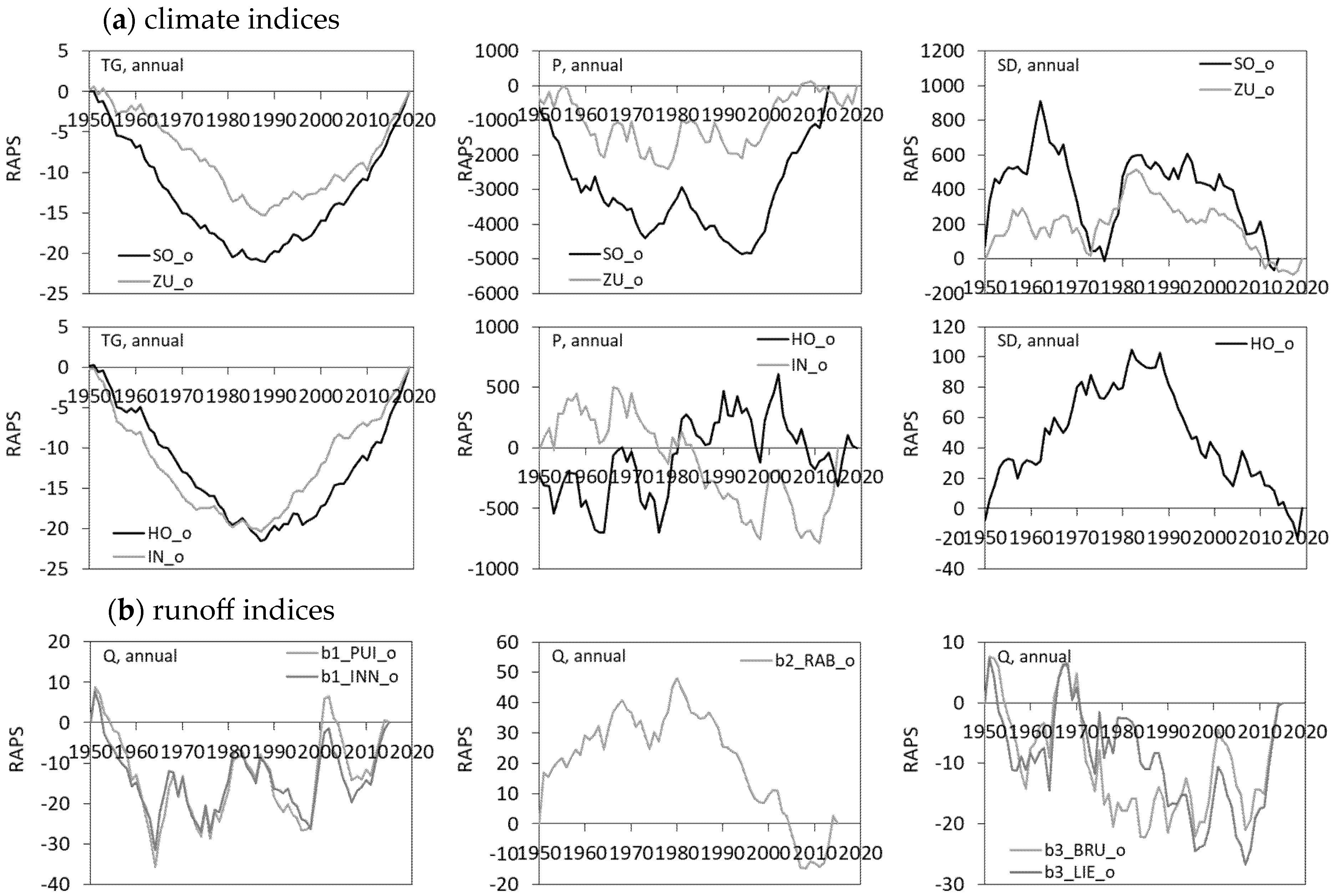
2.4. Long-Term Climate and Runoff Variations

Our intention was to assess the performance of GPPs in a period with relatively constant variations in climate and runoff and without significant perturbations in their trends. The analysis of variations in climate and runoff indices in the longer-term period (1951–2018) enabled the identification of perturbations in the trends and the selection of a period for subsequent assessment of GPPs. In the 1951–2018 period, daily observations of mean air temperature (TG), precipitation (P) and snow depth (SD) were available at four gauges at different elevations: Sonnblick (SO) at 3106 m a.s.l., Zugspitze (ZU) at 2964 m a.s.l., Hohenpeissenberg (HO) at 977 m a.s.l. and Inngolstadt (IN) at 577 m a.s.l. Long-term discharge time series (Q) were available at five stations: at the Puig (PUI) and Innsbruck (INN) stations on the Sill River (b1 catchment), at the Rabland (RAB) station on the Drava River (b2 catchment), and at the Brühl (BRU) and Lienz (LIE) stations on the Isel River (b3 catchment). The locations of the stations are shown in Figure 1.
The average annual climate indices (TG, P, SD) show a clear orographic separation in the pilot area. The TG decreases from +9.8 °C in the valleys to −5.2 °C on the ridge tops, while the annual P increases from 886 mm to 2006 mm as well as the annual SD from 0 cm to 343 cm. The fluctuations and trends of the climate indices are consistent across the area and with the orographic separation (Table 7, Figure 2 and Figure 3). The TG increase is very strong through the period 1951–2018 (statistically significant at p < 0.001 level at all stations). In the 70-year period, TG increased by +2.1 °C, which is consistent with other findings [12,13,14]. The long-term annual TG variations in the period 1951–2018 show a clear break around 1980 (Figure 3), followed by a continuous increase in TG at all altitudes (all stations). After 1981, the TG trends are even stronger and most pronounced at lower elevations (+0.44 °C 10y−1 at station HO), as previously shown [13]. The long-term annual P generally fluctuates around the mean, without obvious breaks. At high elevations, however, a positive P trend is evident, with an increase in long-term means of 12% and 5% (+202 mm and +97 mm at gauges SO and ZU) in the post-1991 period. The long-term negative trends in annual SD are found at all elevations but are stronger in the valleys (statistically significant at p < 0.05 level). The long-term SD fluctuations at lower elevations clearly follow the TG pattern, with a single break in the 1980s and a continuous decline after 1990. After 1981, the long-term annual SD in the valleys decreased by −22% (−5 cm at gauge HO). The SD variations at higher elevations (gauges SO and ZU) resemble the P pattern with several breaks: a decline in the 1960s and 1970s was followed by a brief recovery until the 1980s and a continuous decline after 1990. In the post-1981 period, the mean SD at the mountain tops decreased by −10%, although the mean P increased by +8%. These results confirm a strong impact from the TG increase in the area from previous findings with a shift in precipitation type (from snow to rain) and a strong decrease in snow cover [16,17].
The 1951–2018 long-term trends for the annual Q show alternating variations between the catchments. In catchment b2 Drava, there is a weak negative trend in annual Q, with a clear break around the 1980s (RAPS plots in Figure 3), while in catchments b1 Sill and b3 Isel, there is a weak positive trend without an obvious break. However, after 1981, the annual Q shows a positive trend across the pilot area. After examining the variations and perturbations in the climate and runoff indices in the period 1951–2018, the period after 1991, in which there were no obvious breaks in the TG, P, SD and Q trends, was selected for the evaluation of the GPPs.

2.5. Evaluation Using Hydrological Model

In addition to the point-to-point analysis, the performance of the GPPs was evaluated on an area basis by comparing the runoff from the hydrological model for different precipitation inputs with the observed runoff. A physically based, semi-distributed model SWAT was selected, which has been successfully applied in catchments with snowmelt (Fontaine et al. [115], Grusson et al. [116] and Tuo et al. [89]). Background data, including DEM (25 m grid resolution), soil grid (1000 m resolution) and land cover (100 m resolution), were available from the European land databases (Table 4). The analysis of land cover changes over four consecutive periods (1990–2000, 2000–2006, 2006–2012 and 2012–2018) did not reveal any significant changes, so land cover was considered unchanged in the model simulations. ArcSWAT (version 2012.10.24) was used to extract model parameter values from the background layers and databases. Components calculated in the model include interception, evapotranspiration, soil and snow evaporation, soil and root zone infiltration, surface runoff and groundwater flow.
The calculation of the snow water equivalent (SWE) is influenced by the definition of the air temperatures of snowfall and snowmelt, and the calculation of the snowpack temperature (Tsnow) is influenced by the depth, exposure and density of the snowpack [115]. The lapse rates of air temperature (dT/dZ) and precipitation (dP/dZ) were derived for each of the pilot catchments from the regression between elevation and annual means, as proposed by Fontaine et al. [115]. Five classes of slope definitions and temperature bands were applied, as suggested in previous studies [92,117]. The air temperature in an elevation band for each catchment was used to determine the precipitation type. To determine the amount of meltwater released, the melt coefficient (bmltt) was used, which is defined as a sine wave with a minimum of 0.20 cm/°C on 21 December and a maximum of 0.60 cm/°C on 21 June [89,115,118,119].
To test the performance of the model, we used the SWAT Calibration Uncertainty Programs (SWAT-CUP) with the SUFI-2 algorithm, which has been shown to be appropriate in other similar studies [86,88,89,120]. The aim of a successful calibration is to find the right balance between the two statistical factors (P-factor and R-factor). The performance of the model is considered adequate if the P-factor > 0.7 and the R-factor < 1.5. Nash–Sutcliffe efficiency (NSE) and the coefficient of determination (R2), which are commonly used in snow-dominant catchments [89,90,116], were used to evaluate model skill.
In each of the catchments, two hydrological stations are located in the upper and middle section, with the third at the outlet of the catchment (Figure 1). The model parameters were calibrated for the period 1996–2005, during which several wet and dry years were observed. The model was validated for the period 2009–2013. The snowmelt parameters (SMTMP and TIMP) showed a significant influence on the model performance, as suggested by Ahl et al. [121]. The initial model parameter values were similar to those from the SWAT study in the region (about 100 km southwest of the pilot area) and from other studies in mountainous regions with snow accumulation/melt processes [86,87,89]. Table 8 shows final model parameters for weather, snow, surface runoff and groundwater parameters after the calibration process.
The SWAT model was calibrated suing observed precipitation at a monthly time step. Daily discharge observations from Austria’s national database (eHYD) for nine hydrological stations were upscaled to mean monthly discharge time series. Following common evaluation practices for monthly time step (Moriasi et al. [122]), NSE greater than 0.75 indicates very good model skill, values between 0.65 and 0.75 represent good skill, and values between 0.50 and 0.65 satisfactory skill, while NSE below 0.5 is considered unsatisfactory skill. The NSE determines the relative magnitude of the residual variance [122,123], and previous studies have reported monthly NSE > 0.75 as good model performance [87].
The model skill for the calibration and validation periods (Table 9) shows good performance for catchments b1 and b3 (NSE = 0.90 and 0.93 for the calibration period, NSE = 0.84 and 0.89 for the validation at the outlets). The simulated hydrographs (Figure 4) show that the observed runoff regime for catchments b1 and b3 is well reproduced during both the calibration and validation periods. The model has slightly lower performance in the upstream river sections. The model has worse performance in catchment b2 (NSE = 0.67 for the calibration period and 0.50 for the validation at the outlet). The observed hydrograph in catchment b2 does not show snowmelt-induced high spring discharges as in the other two catchments (Figure 4). One of the probable reasons for the worst performance in catchment b2 is the fact that the Drava River originates from a spring, so that in addition to the inner runoff (from the catchment), an additional inflow influences the river regime, which was not included in the model (the worst performance is shown for the most upstream station, b2_AUS).
To analyze the sensitivity of the adopted model parameters, the global sensitivity method was applied by determining the sensitivity (t-stat) and significance (p-value) statistics (parameters with larger absolute t-stat and smaller p-value have a greater influence on the model results [120]). It was found that the most influential model parameters were SLSUBBSN, CN2 and GW_DELAY. The parameter GW_DELAY is important for the runoff regime in snowmelt-dominated catchments. The model in catchment b1 Sill was also sensitive to changes in RCHRG_DP, indicating the probable influence of percolation in deep aquifers in this catchment.
It was considered that the overall model performance is satisfactory and suitable for the task. Due to the higher model uncertainty in catchment b2 Drava (NSE = 0.50), which is most likely due to additional inflows from the spring (not considered in the model), catchment b2 Drava was excluded from the evaluation of GPPs using the SWAT model.

3. Results

3.1. Performance Evaluation Using Gauge Observations

The observed precipitation and runoff regime in the period 1991–2018 was plotted using vertical averaging, for a comparison between catchments, and horizontal averaging, for a comparison between elevation bands (Figure 5). Annual precipitation Pannual is slightly lower in catchment b2 Drava (966 mm) than in catchments b1 Sill and b3 Isel (1050 mm and 1048 mm). The warm season is much wetter Pwarm = 674 mm than the cold season Pcold = 348 mm. The inter-annual variations in P (Figure 5a) show that most precipitation falls in summer (June, July, August) and late autumn (October, November), with July being the wettest (140 mm), while the winter months are much drier (36 mm in February). The distribution of Pannual in elevation bands shows a precipitation increase with elevation, from 807 mm to 1266 mm, giving a vertical P lapsing rate at 420 mm km−1 (Figure 5b).
The precipitation amounts from the CHIRPS and ERA5 products were compared to observations for the annual, seasonal and monthly time steps in the period 1991–2018 (see Table 10). A general positive P bias is present for both products, but it is significantly lower for CHIRPS than for the ERA5 product (PB_P = 15% CHIRPS, 37% ERA5). The CHIRPS also shows a lower seasonal P bias (warm and cold seasons) at all elevation bands. The performance of both products is lower in the cold than in the warm season. A relatively small bias at higher elevations (>1500 m a.s.l.) (PB_P = 1% CHIRPS, 21% ERA5) increases significantly (PB_P = 50% CHIRPS, 68% ERA5) at lower elevations (<1000 m a.s.l.). This is then reflected in the vertical P lapsing, which is present in both products, but the rate of observed lapsing is not matched by the GPPs (Figure 5b). Both products show an unbalanced performance between catchments (vertical averaging), Figure 6. For the CHIRPS product, a small error in catchments b1 Sill (PB_P = −3%; MAE = 197 mm) and b2 Drava (PB_P = 2%; MAE = 101 mm) is significantly increased in catchment b3 Isel (PB_P = 45%; MAE = 477 mm). The ERA5 product shows a small error in catchment b2 Drava (PB_P = 27%; MAE = 258 mm) but a larger error in catchments b1 Sill (PB_P = 40%; MAE = 421 mm) and b3 Isel (PB_P = 43%; MAE = 449 mm). For the monthly time step, the ERA5 shows a stronger linear correlation to the observations (R2_P = 0.83 CHIRPS, 0.91 ERA5), but the CHIRPS shows a lower bias (PB_P = 15% CHIRPS, 37% ERA5) and lower MAE (MAE_P = 34 mm CHIRPS, 37 mm ERA5), Figure 7. The CHIRPS shows a smaller bias in monthly precipitation for all months except May.
The results show that CHIRPS exhibits a lower bias and ERA5 a higher correlation for precipitation amounts. CHIRPS performs better in catchments b1 and b2, whereas ERA5 outperforms CHIRPS in catchment b3. Both CHIRPS and ERA5 show poorer estimates at lower elevations and during the cold season.
The observed trends in annual precipitation in the period 1991–2018 are uniformly positive in all catchments and at all elevation bands (Table 11). The seasonal precipitation trends are generally positive and statistically significant but show an alternating strength in the vertical bands and between the catchments. While gauge b1_SS (at 1235 m a.s.l.) shows a strongly positive trend in the warm season and a negative trend in the cold season (TPwarm = +43 mm 10y−1 vs. TPcold = −4 mm 10y−1), gauge b2_TO (at similar elevation, 1219 m a.s.l.) shows a contrasting trends, a strongly negative trend in the warm season and a positive trend in the cold season (TPwarm = −24 mm 10y−1 vs. TPcold = +18 mm 10y−1). The observed seasonal trends also vary between catchments. The TPwarm is positive in catchments b1 Sill and b3 Isel but negative in catchment b2 Drava. The TPcold is positive in all catchments but much stronger in catchment b2 Drava. The positive and statistically significant TPmonthly is observed in January (for 44% of gauges), February (for 33% of gauges) and August (for 78% of gauges). The TPmonthly is also positive for May and November, while it is negative in April and October.
The precipitation trends from the CHIRPS and ERA5 products were compared to the observed trends (see Table 11). The precipitation trends are generally overestimated by both products. Generally, the CHIRPS shows lower TP bias, and ERA5 shows lower absolute error and lower discrepancy in the TP significance to the observed trend. The annual trends at lower elevations are significantly overestimated by both products (MAE_TP = 98% CHIRPS, 44% ERA5), which is mainly contributed by overestimated trends in the warm season in valleys. The spatial performance for the annual TP follows the spatial performance for the annual P. The CHIRPS show a higher performance than ERA5 in catchments b1 Sill (MAE_TP = 6 mm 10y−1 CHIRPS, 10 mm 10y−1 ERA5) and b2 Drava (MAE_TP = 27 mm 10y−1 CHIRPS, 33 mm 10y−1 ERA5) and a lower performance than ERA5 in catchment b3 Isel (MAE_TP = 42 mm 10y−1 CHIRPS, 32 mm 10y−1 ERA5). Both products show poor estimates of the seasonal precipitation trends in catchment b2 Drava with an opposite warm seasonal trend and an underestimated cold seasonal trend. For the monthly time step, the ERA5 shows a stronger correlation around the linear regression (R2 _TP = 0.37 CHIRPS, 0.63 ERA5) and a slightly lower error (MAE_TP = 9.5 mm 10y−1 CHIRPS, 7.5 mm 10y−1 ERA5), Figure 8. The bias in TP significance shows a lower number of missed significances in the monthly trends by the ERA5 product (24% misses for CHIRPS, 20% misses for ERA5). Both GPPs captured statistically significant positive TP for January, Februray and August and a statistically significant negative April trend, but only ERA5 replicated negative TP in June and October.
The results of the precipitation trend estimates show a lower bias for CHIRPS but a higher correlation with fewer misses of statistically significant monthly trends for ERA5. Both products overestimate annual precipitation trends, primarily due to overestimation during the warm season and in valley regions. Spatial performance for TP aligns with performance for P: CHIRPS performs better in catchments b1 and b2, while ERA5 performs better in b3. Both products poorly estimate seasonal precipitation trends in catchment b2.

3.2. Performance Evaluation Using Hydrological Model

The runoff regime has a strong seasonal character. Higher runoff in late spring and early summer is driven by snowmelt and early summer storms, while lower runoffs occur in the winter months (January, February, March) (Figure 5a). The specific annual runoff is higher in catchments b1 Sill and b3 Isel (929 and 1050 mm) than in catchment b2 Drava (648 mm), which is mainly due to the higher warm seasonal runoff (Table 12). The inter-annual variations in runoff are particularly evident at the high-elevation stations (b1_KRO, b3_BRU), where summer runoff is more than six-times higher than the winter runoff. The SWAT model simulations with the inputs from the two precipitation products in the period 1991–2018 were compared with the observed runoff at nine hydrological stations in the three catchments. Due to a poorer model performance and the lower estimation of precipitation amounts and trends by the GPPs in catchment b2 Drava, the GPP assessment is primarily based on the model results in catchments b1 Sill and b3 Isel.
The SWAT model forced with measured precipitation (MEAS) underestimates annual runoff at the catchment outlets (PB_Qannual = −13% in b1, −15% in b3). Since both GPPs generally overestimate precipitation amounts, their model outputs may show lower uncertainty when compared directly to observed discharge (OBS) but higher uncertainty relative to the model forced with measured precipitation (MEAS). This discrepancy is accounted for in the evaluation of GPP performance using the hydrological model.
The SWAT model results for both products follow the observed runoff regime, with higher runoff in the warm than in the cold season (Table 12). The performance of the annual model runoff is similar for both products (RMAE_Q = 12% CHIRPS, 19% ERA5); however, the CHIRPS generates more consistent annual and seasonal runoff bias than ERA5 when compared to the model forced with measured precipitation (MEAS). The annual runoff uncertainty in pilot catchments follows the uncertainty of the annual precipitation amounts. The CHIRPS shows higher performance in the annual runoff in catchment b1 (PB_Q = −11% CHIRPS, 28% ERA5, −13% MEAS), while the ERA5 performance is higher in catchment b3 (PB_Q = 11% CHIRPS, −9% ERA5, −15% MEAS). Both products generate a higher model runoff uncertainty in the cold season (RMAE_Q = 30% CHIRPS, 44% ERA5) than in the warm season (RMAE_Q = 10% CHIRPS, 14% ERA5), which is attributed to the poorer estimates of precipitation amounts in the cold season (see previous section).
The CHIRPS generates consistently negative runoff bias in the catchments (PB_Q = −11%), while the ERA5 generates alternating signs in the runoff bias, positive in catchment b1 Sill (PB_Q = 28%) and negative (PB_Q = −9%) in catchment b3 Isel. The unexpected positive runoff bias in catchment b1 for ERA5 is mainly contributed by the high runoff bias in the cold season (PB_Qcold = 56%). The lower ERA5 model performance in catchment b1 can also be attributed to a lower number of grid points (a single grid point at the upper boundary), while the two grid points in the center of catchment b3 improve the ERA5 model performance (see Figure 9a). The model NSE performance at all hydrological stations in catchments b1 and b3 is presented for the GPPs and the measured precipitation forcing (Figure 9b). A correlation between model performance (NSE) and upstream catchment size shows that CHIRPS generates increasing model performance with increasing catchment size and follows the performance when observed precipitation is used, while the ERA5 generates an unexpected decrease in model performance with increasing area. The unexpected ERA5 correlation is mainly influenced by the performance in catchment b1 Sill. A comparison of the model results forced with GPPs and measured precipitation against the observed runoff shows that CHIRPS generates a lower uncertainty for the annual and seasonal runoff (PB_Q, RMAE) in catchment b1 and that ERA5 generates a lower uncertainty for the annual and warm season runoff (PB_Q, RMAE) in catchment b3 than the model with measured precipitation (MEAS). For the monthly time step (Figure 10), the runoffs generated by CHIRPS show a higher performance (lower PB_Q, higher NSE) than ERA5 for all months except May and October. The model was able to replicate the lower ERA5 May precipitation error to the lower ERA5 May runoff uncertainty. The ERA5 mean monthly runoff bias is positive, which is inconsistent with the negative runoff bias generated with measured precipitation. For the monthly time step, the runoff generation with measured precipitation (MEAS) generally outperforms the best GPPs by a relatively small margin (NSE = 0.871 CHIRPS, 0.877 MEAS in catchment b1; NSE = 0.871 ERA5, 0.885 MEAS in catchment b3). The GPP-generated runoff slightly outperforms the MEAS-generated runoff in April (CHIRPS) and June (ERA5).
The runoff results of the SWAT model indicate that both products provide generally comparable performance, with a lower overall runoff RMAE and a higher R2 for CHIRPS. Both products show higher runoff uncertainty in the cold season, likely due to increased precipitation uncertainty in that season. CHIRPS delivers consistent Q performance across pilot catchments, consistently underestimating runoff and increasing skill with increasing catchment size, similar to the model with observed precipitation. In contrast, ERA5 shows spatially inconsistent model performance. At annual and seasonal scales, the model forced with the best-performing GPP outperforms the model using measured precipitation. At the monthly scale, the model with measured precipitation (MEAS) performs slightly better overall, although the GPP-forced simulations outperform measured precipitation in two individual months.
The observed trend in annual runoff (TQannual) is generally positive in all catchments (Table 13). Although not statistically significant, the positive annual runoff trend in catchment b3 Isel (TQannual = 50.0 mm 10y−1) is much stronger than in catchment b1 Sill (TQannual = 30.4 mm 10y−1). The observed cold seasonal trend is uniformly positive and strong in the pilot areas (statistically significant at p < 0.05 level), dominated mainly by the strong April and November trends (positive April trend is statistically significant at p < 0.01 level at 66% of stations). However, the strong April runoff trend is primarily related to the increased snow and ice melt and not to the increase in precipitation (observed April precipitation trend is negative). The observed warm seasonal trend is also positive but weaker than in the cold season and with alternating strength between catchments and months. Positive TQmonthly is observed in May and September (positive September trend is statistically significant at p < 0.05 level at 33% of the stations) and negative in July and October. The negative precipitation trends in July and October are also reflected in negative runoff trends.
The model runoff trends (TQ) forced with GPPs were compared with the observed trends and with the model runoff trends forced with measured precipitation (MEAS). The model results show that the alternating TP performance in the pilot catchments is followed by alternating TQ performance. The CHIRPS shows a lower uncertainty than ERA5 in catchment b1 with underestimated annual TP and TQ (PB_TP = −5%, PB_TQ = −14%), while the ERA5 shows a lower uncertainty than CHIRPS in catchment b3 with overestimated annual TP and TQ (PB_TP = 18%, PB_TQ = 26%). When compared to the TQ generated with measured precipitation (MEAS), both GPPs generate a lower annual TQ uncertainty than the TQ generated with the measured precipitation (MEAS) in catchment b1 (PB_TQ = −13% CHIRPS, −25% ERA5, −41% MEAS) and in catchment b2 (PB_TQ = 35% CHIRPS, 27% ERA5, 44% MEAS). The CHIRPS-generated TQ bias is consistent with the TP bias for the annual and warm season trend (B_TP < 0 and B_TQ < 0 in b1; B_TP > 0 and B_TQ > 0 in b3) and for the cold season trend in b3 (B_TP < 0 and B_TQ < 0). The ERA5 generates inconsistent bias between TQ and TP for the annual and warm season trend in b1 (B_TP > 0 and B_TQ < 0). For the seasonal time step, both GPPs generate a higher TQ uncertainty in the warm season (MAE_TQwarm = 13.5 mm 10y−1 CHIRPS, 16.7 mm 10y−1 ERA5) than in the cold season (MAE_TQcold = 3.8 mm 10y−1 CHIRPS, 6.0 mm 10y−1 ERA5), which is consistent with a higher TP error in the warm season (MAE_TPwarm = 38 mm 10y−1 CHIRPS, 25 mm 10y−1 ERA5) than in the cold season (MAE_TPcold = 24 mm 10y−1 CHIRPS, 16 mm 10y−1 ERA5). CHIRPS generates a somewhat lower TQ uncertainty than ERA5 in both the warm and cold seasons. When compared to the TQ generated with measured precipitation (MEAS), both GPPs generate a lower seasonal TQ uncertainty than the TQ with the measured precipitation (MEAS) in the warm season (CHIRPS in b1, ERA5 in b3) and in the cold season (CHIRPS in b1). For the monthly time step (Figure 11), the CHIRPS generally generates higher correlation (R2_TQ = 0.50 CHIRPS, 0.43 ERA5), lower mean error (MAE_TQ = 4.0 mm 10y−1 CHIRPS, 5.0 mm 10y−1 ERA5) and a lower amount of missed trend significance (8% misses for CHIRPS, 11% misses for ERA5) than ERA5. The general monthly TP performance (lower ERA5 MAE_TP) is not followed by the general monthly TQ performance (lower CHIRPS MAE_TQ). A relatively strong negative TQ in July is generated by both GPPs. The observed statistically significant positive runoff trend in April was also generated by both products, but this trend is dominantly influenced by the air temperature increase and not the precipitation increase. The GPP forcing can outperform the runoff trends with measured precipitation forcing.
Runoff trends from simulations show that CHIRPS slightly outperforms ERA5 with lower bias and deviation in annual, seasonal and monthly runoff trends, with less missed monthly trend significance. CHIRPS performs better in catchment b1, while ERA5 in catchment b3. ERA5 generates inconsistent bias between TQ and TP in catchment b1. Both GPPs perform worse in the warm season, reflecting higher TP uncertainty. A relatively strong negative TQ in July is generated by both GPPs. Compared to the model forced with measured precipitation (MEAS), the best-performing GPPs can generate lower TQ uncertainty at annual and seasonal scales and can outperform MEAS in capturing monthly runoff trends.

4. Discussion

4.1. Evaluation Using Precipitation Observations

In this study, the performance of two gridded precipitation products (GPPs), namely the Climate Hazards Group InfraRed Precipitation with Station data (CHIRPS-V2.0) and the fifth generation of the global weather and climate reanalysis ERA5, was assessed for long-term runoff simulations and runoff trend evaluations in mountainous regions. The pilot area comprised three catchments (b1 Sill with 853 km2, b2 Drava with 669 km2, and b3 Isel catchment with 1197 km2) in the inner Alps in Austria, with similar geophysical characteristics and with a good coverage of ground meteorological and hydrological stations. The catchments share a substantial elevation difference, very steep slopes and similar soil mix. The b1 Sill River flows mainly northwards, and the catchment is covered by 3.6% of glacial ice. The b2 Drava River originates from a spring and flows mainly easterly, and the b3 Isel River rises at the glacier gate and flows mainly southerly. The evergreen forests dominate in catchments b1 and b2, while rock cover predominates in catchment b3. Given that runoff regimes and trends in mountainous areas are driven by a combination of surface (precipitation, evapotranspiration, infiltration, snow/ice melt) and subsurface processes, a spatiotemporal assessment framework was adopted to credibly evaluate GPP performance. The first step involved assessing climate and runoff variations over a longer timeframe to select a relatively uniform trend period. Analyses using 11-year moving averages, linear trends, RAPS, Mann–Kendall statistics, and trend significances for TG, P, SD, and Q between 1951 and 2018 revealed a break around the 1980s. The identified break and all of the resulting long-term trends in the indices (Table 7), along with an increasing TG trend of approximately +0.3 °C 10y−1, are consistent with other studies [20,26,29,30,32,34,124,125,126,127]. The post-1991 period was adopted for GPP assessment due to more consistent trends with fewer perturbations. Secondly, the number of GPP grid points (4/6/9 ERA5 and 39/33/52 CHIRPS grid points in or around catchments b1/b2/b3) differs from the available precipitation gauges (15/12/13 gauges, respectively). To address this mismatch, interpolation methods such as simple averaging, inverse distance weighting, and Thiessen polygons were tested, though no universally optimal method could be identified [51]. To overcome the scale discrepancy, two approaches were evaluated using double mass curves: spatially averaged precipitation from nearby gauges and single gauge data. As the averaged data showed significantly higher bias, selected gauge–grid point pairs were used in the subsequent analysis.
The results show that both CHIRPS and ERA5 overestimate annual and seasonal precipitation, particularly at lower elevations and during the cold season. CHIRPS shows lower annual RMAE_P than ERA5 (25% CHIRPS, 37% ERA5). The CHIRPS annual P performance aligns with findings from the Alto Adige region in Italy, which reported the same absolute P error (25%) [51]. Although ERA5 shows higher annual RMAE_P, it exhibits a lower and more consistent correlation (R2_P = 0.97) across the pilot area. This pattern of ERA5 overestimation with higher correlation is also observed in the Alps and elsewhere in Europe [58,94]. The lower performance in winter was previously reported [128] and can be linked to non-convective precipitation systems, which are difficult for satellite algorithms to detect, and to snow and ice cover that interfere with microwave-based retrievals by producing signals similar to atmospheric ice particles [51]. This leads to mismatches in vertical precipitation lapse rates, which are present in both GPPs but are not accurately captured. A study in Turkey similarly found that GPPs tend to overestimate precipitation in leeward regions and underestimate it in windward areas during winter [57]. On a monthly scale, CHIRPS again shows a lower RMAE (40%) compared to ERA5 (44%), though ERA5 has a higher correlation (R2_P = 0.83 CHIRPS, 0.91 ERA5). A comparable monthly absolute error for CHIRPS (MAE_Pmonthly = 34 mm) was reported in other studies (MAE_Pmonthly = 30.6 mm) [80].
The pattern of precipitation trend performance of products aligns with their P performance. Both products overestimate P trends and more evidently during the warm season and in valleys. CHIRPS shows lower P trend bias, but ERA5 shows a higher P trend correlation with fewer misses of statistically significant monthly trends. CHIRPS shows higher annual P and TP performance in catchments b1 and b2, while ERA5 shows higher P and TP performance in catchment b3. The cascaded performance of GPPs from P to TP has been reported, along with similar TP performance between CHIRPS and ERA-Interim (Error_TP = 1.87% y−1 CHIRPS, 1.97% y−1 ERA-Interim) [80]. Regarding monthly precipitation trends, ERA5 exhibits a closer alignment with observed trends (MAE_TPmonthly = 9.5 mm 10y−1 CHIRPS, 7.5 mm 10y−1 ERA5) and fewer missed trend significances compared to CHIRPS. Both products successfully captured the observed significant positive TP trends in January, February, and August. The August trend, observed at 78% of gauges, is likely linked to increased topographically induced summer convection [16].
The point-to-point assessment of GPPs indicates that both CHIRPS and ERA5 tend to overestimate annual and seasonal precipitation amounts as well as precipitation trends, particularly at lower elevations. The observed vertical precipitation lapse rate is inconsistent across the pilot area, resonating with findings from other mountainous regions [57] and reinforcing the idea that a simple lapse rate cannot be reliably applied in the Alps and should be used with caution [23,57]. While observed annual TP during the 1991–2018 period is consistently positive across all catchments and elevation bands, seasonal TP trends show varying strengths across elevation bands and between catchments. This strong spatial and vertical variability in seasonal TP is consistent with findings from other studies in the Alps [129]. These results highlight a pronounced topographic influence on precipitation, with slope and terrain shielding playing a significant role in modulating precipitation patterns in the Alps. These complexities limit the effectiveness of point-to-point GPP evaluation and underscore the importance of integrating hydrological modelling to support a more comprehensive assessment of GPP performance in mountainous regions.

4.2. Evaluation Using Hydrological Modelling

Several processes, in addition to precipitation, were found to significantly influence runoff regimes and trends. The observed runoff regime shows a strong seasonal pattern, with higher flows in late spring and early summer driven by snowmelt and early summer storms. In catchment b2, runoff is primarily driven by spring discharge, which is reflected in the low performance of the SWAT model in this catchment. Long-term annual runoff (1951–2018) in catchment b2 shows a decreasing trend, in contrast to the increasing trends observed in the other two catchments (see Figure 2). During the 1991–2018 period, runoff trends show notable spatial and temporal variability, consistent with findings from other mountainous regions [19,25,26,27,28]. Secondly, annual Q trends are positive across all elevation bands, with stronger increases at lower elevations. In contrast, reduced runoff at higher elevations (stations b1_KRO and b3_BRU) is likely linked to increased evapotranspiration and snow depth decreases [25,26]. Thirdly, significantly increasing April flows, statistically significant at four hydrological stations, could not be explained by the April precipitation trend but rather by enhanced and earlier snowmelt [19] and a shift from snow to rain due to rising air temperatures [16,17,25,31]. Similarly, the strong May runoff trend significantly contributes to the overall warm season runoff trend (TQwarm = 19.8 mm 10y−1) in catchments b1 and b3. Both catchments, located above 3000 m a.s.l., are glacier-covered, and the pronounced April-May runoff trends (Table 13) are likely driven by intensified glacier melt in recent decades [21,22]. Land cover change in the pilot area between 1990 and 2018 confirms a substantial reduction in glacier-covered areas in catchments b1 and b3 (Table 14), consistent with EEA findings [29]. Snow depth records also show a marked decline across the pilot area (Table 7, Figure 2), aligning with broader observations in the Alps [124]. Alongside these cryospheric changes, a pronounced increase in May precipitation (TP = 10.1 mm 10y−1) was observed, suggesting that increasing May runoff results from both enhanced snow and ice melt in spring and increased precipitation. Lastly, the warm season runoff trend in catchment b3 (TQwarm = 29.6 mm 10y−1) is significantly stronger than in catchment b1 (TQwarm = 9.9 mm 10y−1), a difference not explained by precipitation trends alone, as catchment b3 has a lower warm season precipitation increase (TPwarm = 31 mm 10y−1) than catchment b1 (TPwarm = 38 mm 10y−1). This spatial discrepancy likely stems from differences in ice and permafrost melt, driven by differing physical characteristics: b3 is generally south-facing and at a lower elevation, while b1 is north-facing and at a higher elevation. While dominant processes such as spring discharge in catchment b2 or enhanced melt influencing April/May runoff trend are relatively easy identifiable, quantifying the relative contributions of climatic, environmental, and geophysical drivers in a transient environment is more complex and beyond the scope of this study. Nevertheless, key hydrometeorological processes and factors were considered while assessing GPP performance.
The SWAT model performs well in catchments b1 and b3 (NSE = 0.900 and 0.930 at the outlets), accurately reproducing the observed runoff regime. In contrast, model performance is lower in catchment b2 (NSE = 0.670), likely due to its spring-dominated runoff regime. SWAT simulations confirm that both CHIRPS and ERA5 reproduce the seasonal runoff pattern, with higher runoff in the warm season, and provide comparable model performance. Overall model performance improves from ERA5 (NSE = 0.758) to CHIRPS (0.865) and observed precipitation (0.881), consistent with previous SWAT applications in Alpine catchments using CHIRPS and measured precipitation as inputs (NSE = 0.810 and 0.830, respectively) [64]. Previous studies [75,76] similarly report acceptable SWAT performance using CHIRPS and other satellite-based products (such as CFSR, structurally comparable to ERA5), with CHIRPS often performing higher. Findings using other hydrological models support the SWAT model results. A study in a mountainous catchment in Turkey [128] showed that ERA5 underperformed when the model was calibrated with observed precipitation, while CHIRPS2.0 performed higher when GPP was used for model calibration (NSE = 0.750 CHIRPS, 0.630 ERA5). Similarly, a study over African catchments [8] reported that CHIRPS slightly outperformed ERA5 in streamflow modelling with emphasis on climate change scenarios. Both GPPs generate lower runoff performance during the cold season, cascading lower GPP precipitation performance in that season. CHIRPS generates consistent runoff performance across the pilot areas, generally underestimating runoff but increasing skill with increasing catchment size, mirroring correlation when using observed precipitation. ERA5, in contrast, produces inconsistent model performance across pilot catchments. At the monthly time step, CHIRPS generates lower runoff uncertainty than ERA5 (RMAE_Qmonth = 20% CHIRPS, 26% ERA5). At the annual and seasonal time steps, the model forced with the best-performing GPP outperforms the model using measured precipitation, while at the monthly time steps, the model using measured precipitation performs marginally higher than the model using the best-performing GPP.
Simulated runoff trends (TQ) show that annual runoff trend performance closely follows precipitation trend performance (TP). Both products generate similar annual TQ uncertainty (MAE_TQannual = 10.8 mm 10y−1 CHIRPS, 10.6 mm 10y−1 ERA5) and lower TQ performance in the warm season, cascading the similar annual and lower warm season TP performances. Similarly, CHIRPS generates lower TP and TQ uncertainties in catchment b1 and ERA5 in catchment b3. CHIRPS generates consistent TQ and TP biases for the annual and seasonal time steps, while ERA5 generates opposite precipitation and runoff biases in catchment b1 (PB_TPannual = 25%; PB_TQ = −25%). At the monthly time step, CHIRPS outperforms ERA for TQ, generating higher correlation (R2_TQmonthly = 0.55 CHIRPS, 0.43 ERA5), lower mean error (MAE_TQmonthly = 4.0 mm 10y−1 CHIRPS, 5.0 mm 10y−1 ERA5) and a lower amount of missed trend significance. Both products generate a relatively strong negative TQ in July, matching the observed runoff trend. Annual and seasonal TQ uncertainty is lower for the best-performing GPP than for the model using measured precipitation, indicating their strong potential for long-term hydrological simulations. The model forced with the best-performing GPP can outperform simulations using measured precipitation for some months.
CHIRPS’s lower RMAE in annual precipitation (25% CHIRPS, 37% ERA5) is cascaded to a lower RMAE in simulated annual runoff (12% CHIRPS, 19% ERA5). Similarly, higher cold season precipitation RMAE (39% CHIRPS, 51% ERA5) corresponds to elevated runoff RMAE during the same period (30% CHIRPS, 44% ERA5). A higher annual TP performance, CHIRPS in catchment b1 and ERA5 in catchment b3, also translates into higher TQ performance in the respective catchments. Conversely, lower warm season TP estimates from both GPPs are mirrored by lower TQ performance during the same season. These consistent performance cascades from precipitation and precipitation trends to runoff and runoff trends confirm the substantial impact of precipitation performance on hydrological model outputs in the pilot area.
Despite spatially homogeneous ERA5 performance for annual P (PB_P = 40% in b1, 43% in b3) and annual TP (PB_TP = 10% in b1, 14% in b3), this consistency is not reflected in homogeneous Q performance (PB_Q = 28% in b1, −9% in b3). In contrast, Q performance for CHIRPS (PB_Q = −11% in b1, −11% in b3) and measured precipitation (PB_Q = −13% in b1, −15% in b3) are spatially homogeneous, even though CHIRPS shows notable spatial variability in annual P (PB_Q = −3% in b1, 45% in b3) and annual TP (PB_TQ = −6% in b1, 31% in b3). Furthermore, ERA5 shows the highest performance among all three precipitation inputs in catchment b3 for Q (PB_Q = −11% CHIRPS, −9% ERA5, −15% MEAS) and TQ (PB_TQ = 35% CHIRPS, 27% ERA5, 44% MEAS) but the lowest in catchment b1 (PB_Q = −11% CHIRPS, 28% ERA5, −13% MEAS) and TQ (PB_TQ = −13% CHIRPS, −25% ERA5, −41% MEAS). This spatial inconsistency is largely attributed to ERA5’s coarser resolution and fewer grid points. Catchment b3 benefits from two ERA5 grid points near its centroid, while catchment b1 has only one point, located at its upper boundary. Additionally, ERA5 performance in b1 does not improve with increasing catchment size, whereas such a correlation is evident in b3 (Figure 9b). These findings suggest that the spatial resolution and placement of GPP grid points are critical for reliable hydrological modelling in mountainous terrain. Coarser-resolution products with few or poorly placed grid points can yield spatially inconsistent runoff estimates, regardless of their apparent precipitation accuracy. In mountainous catchments smaller than 1000 km2, CHIRPS consistently generates lower runoff and trend uncertainties. In catchments larger than 1000 km2, runoff uncertainty becomes comparable between CHIRPS and ERA5. This aligns with findings from North America [78], where ERA5-generated performance was largely independent of catchment size in catchments larger than 1000 km2.
Although ERA5 exhibits a larger bias monthly precipitation compared to CHIRPS, its consistently higher correlation with observed precipitation indicates that ERA5 effectively captures the temporal precipitation dynamics across the study area. This bias in ERA5 could be mitigated by applying one of the bias-correction methods prior to its use in hydrological models. Recent studies applying univariate/multivariate statistical methods and supervised machine learning techniques to the ERA5-Land product in Alto Adige in Italy have demonstrated the effectiveness of multivariate and machine learning approaches for ERA5 bias correction in complex terrains [130]. Despite the observed biases in both GPPs, this study implemented only indirect correction through the calibration of snowmelt-related parameters in SWAT model development (Table 8), a recommended approach for mountainous catchments of complex topography [89] and when snowmelt parameters influence model performance [68,131]. Nevertheless, previous studies have shown that directly bias-corrected precipitation inputs significantly improve SWAT model performance [132]. Therefore, even with its initial precipitation bias, ERA5 could potentially outperform CHIRPS in hydrological modelling applications if appropriate bias correction techniques are applied.
Some uncertainties in hydrological modelling remain. Although CHIRPS shows lower uncertainty in monthly TQ, this is inconsistent with the lower monthly TP error observed for ERA5. Several modelling-related factors may explain this discrepancy. In glaciated Alpine catchments, a comparable contribution to overall model uncertainty can be explained by the chosen modelling approach and parameter estimation for evapotranspiration and snow/ice accumulation/melt in addition to precipitation [6,7]. The absence of a glacier melt component in the SWAT model may limit the results of GPP performance assessment based on generated runoff in glacierized catchments. For more reliable long-term evaluations of GPPs in such contexts, a distributed hydrological model with an explicit glacier melt module is recommended. In addition, evidence from a study of 273 Austrian catchments (1976–2006) [5] indicates that key model parameters related to snow and soil moisture (e.g., snow correction factor, degree-day factor, soil moisture capacity, and runoff non-linearity) exhibited significant trends over time. These changes were linked to increasing air temperatures, elevated evapotranspiration, and drying catchments, highlighting that the assumption of time-invariant parameters can impede long-term runoff simulations. Therefore, for a more robust evaluation of GPP performance in a changing environment, incorporating time-varying parameters for snow and soil moisture processes can be recommended.

5. Conclusions

This study evaluated the performance of two gridded precipitation products (GPPs), CHIRPS and ERA5, as alternative inputs to the SWAT hydrological model in three pilot catchments in the inner Austrian Alps. The objective was to assess the suitability of GPPs for long-term runoff simulations, through a combination of point-to-point comparisons of precipitation amounts and trends and comparisons between simulated and observed runoff and runoff trends. The key conclusions are as follows:
  • Both gridded precipitation products (GPPs) effectively replicate the observed precipitation patterns and reproduce the observed runoff regime. CHIRPS generally outperforms ERA5, showing lower RMAE in annual (25% CHIRPS, 37% ERA5) and monthly (40% CHIRPS, 44% ERA5) precipitation estimates. This translates into improved runoff performance, with CHIRP achieving lower RMAE in annual (12% CHIRPS, 20% ERA5) and monthly (20% CHIRPS, 26% ERA5) runoff. Despite its higher bias in precipitation and runoff, ERA5 demonstrates a higher correlation and a more consistent performance in precipitation amounts and trends across elevation bands and pilot catchments. This consistency likely stems from ERA5’s reanalysis framework, but it is limited by coarser resolution. The comparable performance of CHIRPS and ERA5 aligns with findings from earlier studies in the Alps [51,58,94].
  • The evaluation of GPP precipitation trend performance has received limited research attention. Trend analysis shows that both GPPs generally follow observed precipitation trends and are capable of reproducing observed long-term runoff trends. Their performance in capturing precipitation trends is comparable to that for precipitation amounts. While precipitation trends are generally overestimated, CHIRPS shows lower precipitation trend bias at annual, seasonal, and monthly scales. This cascaded GPP performance, from precipitation amounts to precipitation trends, has been reported previously, including similar precipitation trend performance between CHIRPS and ERA-Interim (Error_TP = 1.87% y−1 CHIRPS, 1.97% y−1 ERA-Interim) [80].
  • CHIRPS’s lower RMAE in annual precipitation corresponds to a lower annual runoff error than ERA5, while ERA5’s higher cold season precipitation results in elevated runoff RMAE relative to CHIRPS. Similarly, spatial patterns of precipitation trend errors are reflected in the corresponding runoff trend errors in the respective catchments. Seasonal precipitation trend error is likewise mirrored by seasonal runoff trend error. These consistent cascade of errors from precipitation and precipitation trends to runoff and runoff trends highlight the substantial impact of precipitation performance on hydrological model outputs in the pilot area.
  • Some systematic overestimations of precipitation and precipitation trends are evident. Both products overestimate precipitation at lower elevations and during cold season. These biases likely stem from challenges in capturing winter precipitation from non-convective systems and snow-covered surfaces, particularly in complex alpine terrain. Additionally, both GPPs tend to overestimate precipitation trends during the warm season.
  • The spatial resolution of GPPs substantially influences hydrological model performance in mountainous areas, independent of GPP performance in representing precipitation amounts and trends. CHIRPS’s finer spatial resolution (0.05°), gauge correction, and enhanced ability to capture orographically induced precipitation make it more suitable for complex mountainous terrain. CHIRPS’s more reliable runoff trend estimates and fewer missed trend significance counts at the monthly scale strengthen its advantage for long-term hydrological simulations in multiple mountainous catchments, particularly smaller ones. In contrast, ERA5’s coarser grid may limit its ability to accurately resolve orographic precipitation patterns in smaller catchments. However, its strong performance in catchment b3, where grid alignment is more centrally located, emphasizes the importance of spatial alignment between GPP resolution and catchment morphology. Given its lower error and finer spatial resolution, CHIRPS can be recommended for hydrological modelling in catchments smaller than 1000 km2, whereas ERA5 can be comparably suitable for applications in larger catchments, though this requires further confirmation.
  • ERA5 demonstrates a higher correlation with observed precipitation despite exhibiting a larger precipitation bias than CHIRPS. This suggests that ERA5 more accurately captures precipitation temporal variability, indicating the potential for improved runoff generation if bias correction techniques are applied. While CHIRPS shows better raw precipitation and runoff estimates due to its finer spatial resolution and lower initial biases, ERA5 could ultimately generate improved model performance after appropriate debiasing. Future work should explicitly investigate the impacts of bias correction on the ERA5 generated model performance in catchments with complex topography.
  • Model runoffs generated with measured precipitation outperform those generated using the best GPPs by a relatively small margin. This indicates that GPPs are not only viable substitutes for ground-based data but may, under certain conditions, outperform sparse or biased observational datasets in estimating both runoff and runoff trends. However, in this study, the GPP runoff was generated by a hydrologic model developed based on observed precipitation, so the GPP-generated runoff would perform differently if the model had been developed based on precipitation products.
  • Scale discrepancies between precipitation gauges and GPPs are a common challenge. Although interpolation techniques (simple averaging, inverse distance weighting, Thiessen polygons) are often used to mitigate these mismatches, no single method proves universally optimal across all areas [51]. This study observed better performance with selected point-to-point comparisons rather than with spatially averaged precipitation. This highlights the importance of the careful selection of gauge–grid pairs in mountainous regions, where orographic effects are significant. Further research on preprocessing techniques for GPP assessments in complex terrains is recommended to enhance accuracy and applicability.
  • The performance of GPPs in representing precipitation amounts and trends cascades directly into the accuracy of simulated runoff and runoff trends. CHIRPS exhibits lower uncertainties in runoff estimates for catchments b1 and b2, while ERA5 performs better in catchment b3. Beyond precipitation data quality, the performance of runoff simulations is also influenced by local geomorphological and hydroclimatic conditions. Therefore, careful consideration of these site-specific factors is essential when evaluating the long-term suitability of GPPs for hydrological applications in mountainous regions.
The study results demonstrate that CHIRPS is a reliable gridded precipitation product (GPP) suitable for long-term hydrological modelling in small- to medium-sized Alpine catchments, particularly in areas with limited or unreliable gauged precipitation data. However, several uncertainties remain. The absence of a glacier melt module in SWAT may reduce model accuracy in glacierized regions. Additionally, the use of time-invariant model parameters limits the model’s ability in capturing climate-sensitive processes, such as snow dynamics and evapotranspiration. Future research should consider the application of distributed hydrological models with glacier components and explore time-varying calibration strategies to better represent changing snow, ice, and soil moisture conditions. Moreover, further studies should investigate the impacts of ERA5 bias correction to comprehensively assess its contribution to runoff generation in catchments with complex topography. Further assessments should also examine the performance of various GPPs across different pilot catchments and larger geographic domains, incorporating other satellite-based and reanalysis products, such as MSWEP-2.2 and others. Such efforts would enhance the generalizability and scalability of the findings.

Author Contributions

Conceptualization, D.B.; methodology, D.B. and K.L.; software, K.L.; validation, D.B.; formal analysis, D.B.; investigation, D.B. and K.L.; resources, D.B. and K.L.; data curation, K.L.; writing—original draft preparation D.B. and K.L.; writing—review and editing, D.B.; visualization, D.B. and K.L.; supervision, D.B. All authors have read and agreed to the published version of the manuscript.

Funding

This research received no external funding.

Data Availability Statement

The input data for the study were obtained from the following resources available in the public domain: Land: Digital elevation model (DEM) Copernicus—EU DEM v 1.1, https://land.copernicus.eu/imagery-in-situ/eu-dem/eu-dem-v1.1 (accessed on 10 September 2018); European Environment Agency, European Soil Data Centre (ESDAC), https://esdac.jrc.ec.europa.eu/ (accessed on 11 September 2018); European Environment Agency, Corine Land Cover (CLC) 2006 ver. 20, https://land.copernicus.eu/pan-european/corine-land-cover/clc-2006 (accessed on 11 September 2018). Climate and streamflow: Air temperature, precipitation, snow depth—European Climate Assessment & Dataset (ECA&D) https://www.ecad.eu (accessed on 20 March 2019). Precipitation - Bundesministerium für Nachhaltigkeit und Tourismus—eHYD, https://ehyd.gv.at/# (accessed on 18 March 2019). Precipitation - Autonome Provinz Bozen, http://weather.provinz.bz.it (accessed on 18 March 2019). Discharge—Bundesministerium für Nachhaltigkeit und Tourismus—eHYD, https://ehyd.gv.at/# (accessed on 18 March 2019). Climate products: Temperature, wind speed, solar radiation, humidity (CFSR), National Centers for Environmental Prediction (NCEP) https://www.uoguelph.ca/watershed/w3s (accessed on 25 April 2019). Precipitation—CHIRPS-V2.0 Climate Hazards Group InfraRed Precipitation with Station, ftp://ftp.chg.ucsb.edu/pub/org/chg/products/CHIRPS-2.0 (accessed on 25 April 2019). Precipitation—ERA5 Grid—European Centre for Medium-Range Weather Forecasts—ERA5, https://cds.climate.copernicus.eu/cdsapp#!/dataset/reanalysis-era5-single-levels?tab=form (accessed on 25 April 2019). The raw data supporting the conclusions of this article will be made available by the authors on request.

Acknowledgments

We sincerely thank Elisabeth Holzhammer, Reinhold Godina and Martin Neuner for providing necessary hydrological and meteorological data that were not publicly available at the time, significantly enhancing the quality of the models developed in this paper. We are also grateful to the two anonymous reviewers for their valuable comments and suggestions, which have improved the clarity and overall quality of the manuscript.

Conflicts of Interest

The authors declare no conflicts of interest.

References

  1. Pan, S.; Liu, D.; Wang, Z.; Zhao, Q.; Zou, H.; Hou, Y.; Liu, P.; Xiong, L. Runoff Responses to Climate and Land Use/Cover Changes under Future Scenarios. Water 2017, 9, 475. [Google Scholar] [CrossRef]
  2. KlemeŠ, V. Operational Testing of Hydrological Simulation Models. Hydrol. Sci. J. 1986, 31, 13–24. [Google Scholar] [CrossRef]
  3. Bronstert, A. Rainfall-Runoff Modeling for Assessing Impacts of Climate and Land Use Change. In Encyclopedia of Hydrological Sciences; John Wiley & Sons, Ltd.: Chichester, UK, 2005. [Google Scholar]
  4. Blöschl, G.; Montanari, A. Climate Change Impacts—Throwing the Dice? Hydrol. Process. 2010, 24, 374–381. [Google Scholar] [CrossRef]
  5. Merz, R.; Parajka, J.; Blöschl, G. Time Stability of Catchment Model Parameters: Implications for Climate Impact Analyses. Water Resour. Res. 2011, 47, W02531. [Google Scholar] [CrossRef]
  6. Addor, N.; Rössler, O.; Köplin, N.; Huss, M.; Weingartner, R.; Seibert, J. Robust Changes and Sources of Uncertainty in the Projected Hydrological Regimes of Swiss Catchments. Water Resour. Res. 2014, 50, 7541–7562. [Google Scholar] [CrossRef]
  7. Duethmann, D.; Bloschl, G.; Parajka, J. Why Does a Conceptual Hydrological Model Fail to Correctly Predict Discharge Changes in Response to Climate Change? Hydrol. Earth Syst. Sci. 2020, 24, 3493–3511. [Google Scholar] [CrossRef]
  8. Tarek, M.; Brissette, F.; Arsenault, R. Uncertainty of Gridded Precipitation and Temperature Reference Datasets in Climate Change Impact Studies. Hydrol. Earth Syst. Sci. 2021, 25, 3331–3350. [Google Scholar] [CrossRef]
  9. Ivezic, V.; Bekic, D.; Horvat, B. Modelling of Basin Wide Daily Evapotranspiration with a Partial Integration of Remote Sensing Data. Atmosphere 2018, 9, 120. [Google Scholar] [CrossRef]
  10. Ivezic, V.; Bekic, D.; Kerin, I. Estimating Basin-Wide Air Temperature by Partial Integration of Remote Sensing Data. Can. J. Earth Sci. 2018, 55, 1196–1206. [Google Scholar] [CrossRef]
  11. Bekić, D.; Halkijević, I.; Gilja, G.; Lončar, G.; Carević, D.; Potočki, K. Examples of Trends in Water Management Systems under Influence of Modern Technologies. Gradjevinar 2019, 71, 833–842. [Google Scholar] [CrossRef]
  12. Birsan, M.V.; Molnar, P.; Burlando, P.; Pfaundler, M. Streamflow Trends in Switzerland. J. Hydrol. 2005, 314, 312–329. [Google Scholar] [CrossRef]
  13. Beniston, M.; Rebetez, M.; Giorgi, F.; Marinucci, M.R. An Analysis of Regional Climate Change in Switzerland. Theor. Appl. Climatol. 1994, 49, 135–159. [Google Scholar] [CrossRef]
  14. Auer, I.; Böhm, R.; Jurkovic, A.; Lipa, W.; Orlik, A.; Potzmann, R.; Schöner, W.; Ungersböck, M.; Matulla, C.; Briffa, K.; et al. HISTALP—Historical Instrumental Climatological Surface Time Series of the Greater Alpine Region. Int. J. Climatol. 2007, 27, 17–46. [Google Scholar] [CrossRef]
  15. Widmann, M.; Schär, C. A Principal Component and Long-Term Trend Analysis of Daily Precipitation in Switzerland. Int. J. Climatol. 1997, 17, 1333–1356. [Google Scholar] [CrossRef]
  16. Matiu, M.; Crespi, A.; Bertoldi, G.; Maria Carmagnola, C.; Marty, C.; Morin, S.; Schöner, W.; Cat Berro, D.; Chiogna, G.; De Gregorio, L.; et al. Observed Snow Depth Trends in the European Alps: 1971 to 2019. Cryosphere 2021, 15, 1343–1382. [Google Scholar] [CrossRef]
  17. Scherrer, S.C.; Appenzeller, C.; Laternser, M. Trends in Swiss Alpine Snow Days: The Role of Local- and Large-Scale Climate Variability. Geophys. Res. Lett. 2004, 31, L13215. [Google Scholar] [CrossRef]
  18. Laternser, M.; Schneebeli, M. Long-Term Snow Climate Trends of the Swiss Alps (1931–99). Int. J. Climatol. 2003, 23, 733–750. [Google Scholar] [CrossRef]
  19. Klein, G.; Vitasse, Y.; Rixen, C.; Marty, C.; Rebetez, M. Shorter Snow Cover Duration since 1970 in the Swiss Alps Due to Earlier Snowmelt More than to Later Snow Onset. Clim. Change 2016, 139, 637–649. [Google Scholar] [CrossRef]
  20. Fatichi, S.; Rimkus, S.; Burlando, P.; Bordoy, R.; Molnar, P. Elevational Dependence of Climate Change Impacts on Water Resources in an Alpine Catchment. Hydrol. Earth Syst. Sci. Discuss. 2013, 10, 3743–3794. [Google Scholar] [CrossRef]
  21. Bliss, A.; Hock, R.; Radić, V. Global Response of Glacier Runoff to Twenty-First Century Climate Change. J. Geophys. Res. Earth Surf. 2014, 119, 717–730. [Google Scholar] [CrossRef]
  22. Radić, V.; Hock, R. Glaciers in the Earth’s Hydrological Cycle: Assessments of Glacier Mass and Runoff Changes on Global and Regional Scales. Surv. Geophys. 2014, 35, 813–837. [Google Scholar] [CrossRef]
  23. Filippa, G.; Cremonese, E.; Galvagno, M.; Isabellon, M.; Bayle, A.; Choler, P.; Carlson, B.Z.; Gabellani, S.; di Cella, U.M.; Migliavacca, M. Climatic Drivers of Greening Trends in the Alps. Remote Sens. 2019, 11, 2527. [Google Scholar] [CrossRef]
  24. Carlson, B.Z.; Corona, M.C.; Dentant, C.; Bonet, R.; Thuiller, W.; Choler, P. Observed Long-Term Greening of Alpine Vegetation—A Case Study in the French Alps. Environ. Res. Lett. 2017, 12, 114006. [Google Scholar] [CrossRef]
  25. Zierl, B.; Bugmann, H. Global Change Impacts on Hydrological Processes in Alpine Catchments. Water Resour. Res. 2005, 41, W02028. [Google Scholar] [CrossRef]
  26. Bavay, M.; Grünewald, T.; Lehning, M. Response of Snow Cover and Runoff to Climate Change in High Alpine Catchments of Eastern Switzerland. Adv. Water Resour. 2013, 55, 4–16. [Google Scholar] [CrossRef]
  27. Leitinger, G.; Tasser, E.; Newesely, C.; Obojes, N.; Tappeiner, U. Seasonal Dynamics of Surface Runoff in Mountain Grassland Ecosystems Differing in Land Use. J. Hydrol. 2010, 385, 95–104. [Google Scholar] [CrossRef]
  28. Hohmann, C.; Kirchengast, G.; Birk, S. Alpine Foreland Running Drier? Sensitivity of a Drought Vulnerable Catchment to Changes in Climate, Land Use, and Water Management. Clim. Change 2018, 147, 179–193. [Google Scholar] [CrossRef]
  29. European Environment Agency. EEA Regional Climate Change and Adaptation—The Alps Facing the Challenge of Changing Water Resources; EEA Report; Office for Official Publications of the European Communities: Luxembourg, 2009; pp. 1–143. [Google Scholar] [CrossRef]
  30. Viviroli, D.; Archer, D.R.; Buytaert, W.; Fowler, H.J.; Greenwood, G.B.; Hamlet, A.F.; Huang, Y.; Koboltschnig, G.; Litaor, M.I.; López-Moreno, J.I.; et al. Climate Change and Mountain Water Resources: Overview and Recommendations for Research, Management and Policy. Hydrol. Earth Syst. Sci. 2011, 15, 471–504. [Google Scholar] [CrossRef]
  31. Fehlmann, M.; Gascón, E.; Rohrer, M.; Schwarb, M.; Stoffel, M. Improving Medium-Range Forecasts of Rain-on-Snow Events in Prealpine Areas. Water Resour. Res. 2019, 55, 7638–7661. [Google Scholar] [CrossRef]
  32. Kling, H.; Fuchs, M.; Paulin, M. Runoff Conditions in the Upper Danube Basin under an Ensemble of Climate Change Scenarios. J. Hydrol. 2012, 424–425, 264–277. [Google Scholar] [CrossRef]
  33. Toreti, A.; Masante, D.; Acosta Navarro, J.; Bavera, D.; Cammalleri, C.; De Jager, A.; Di Ciollo, C.; Hrast Essenfelder, A.; Maetens, W.; Magni, D.; et al. Drought in Europe July 2022; Publications Office of the European Union: Luxembourg, 2022. [Google Scholar] [CrossRef]
  34. Barontini, S.; Grossi, G.; Kouwen, N.; Maran, S.; Scaroni, P.; Ranzi, R. Impacts of Climate Change Scenarios on Runoff Regimes in the Southern Alps. Hydrol. Earth Syst. Sci. Discuss. 2009, 6, 3089–3141. [Google Scholar] [CrossRef]
  35. Jain, S.K.; Jain, S.K.; Jain, N.; Xu, C.-Y. Hydrologic Modeling of a Himalayan Mountain Basin by Using the SWAT Mode. Hydrol. Earth Syst. Sci. Discuss. 2017, 1–26. [Google Scholar] [CrossRef]
  36. Farinotti, D.; Usselmann, S.; Huss, M.; Bauder, A.; Funk, M. Runoff Evolution in the Swiss Alps: Projections for Selected High-Alpine Catchments Based on ENSEMBLES Scenarios. Hydrol. Process. 2012, 26, 1909–1924. [Google Scholar] [CrossRef]
  37. Leskovar, K.; Mrakužić, P.; Meaški, H. Evaluation of Remotely Sensed Precipitation Product in a Hydrological Model of the Bednja Watershed. Gradjevinar 2021, 73, 335–348. [Google Scholar] [CrossRef]
  38. Funk, C.; Peterson, P.; Landsfeld, M.; Pedreros, D.; Verdin, J.; Shukla, S.; Husak, G.; Rowland, J.; Harrison, L.; Hoell, A.; et al. The Climate Hazards Infrared Precipitation with Stations—A New Environmental Record for Monitoring Extremes. Sci. Data 2015, 2, 150066. [Google Scholar] [CrossRef] [PubMed]
  39. Thirel, G.; Notarnicola, C.; Kalas, M.; Zebisch, M.; Schellenberger, T.; Tetzlaff, A.; Duguay, M.; Mölg, N.; Burek, P.; de Roo, A. Assessing the Quality of a Real-Time Snow Cover Area Product for Hydrological Applications. Remote Sens. Environ. 2012, 127, 271–287. [Google Scholar] [CrossRef]
  40. Schneider, U.; Becker, A.; Finger, P.; Meyer-Christoffer, A.; Ziese, M.; Rudolf, B. GPCC’s New Land Surface Precipitation Climatology Based on Quality-Controlled in Situ Data and Its Role in Quantifying the Global Water Cycle. Theor. Appl. Climatol. 2014, 115, 15–40. [Google Scholar] [CrossRef]
  41. Chen, M.; Shi, W.; Xie, P.; Silva, V.B.S.; Kousky, V.E.; Wayne Higgins, R.; Janowiak, J.E. Assessing Objective Techniques for Gauge-Based Analyses of Global Daily Precipitation. J. Geophys. Res. 2008, 113, D04110. [Google Scholar] [CrossRef]
  42. Cornes, R.C.; van der Schrier, G.; van den Besselaar, E.J.M.; Jones, P.D. An Ensemble Version of the E-OBS Temperature and Precipitation Data Sets. J. Geophys. Res. Atmos. 2018, 123, 9391–9409. [Google Scholar] [CrossRef]
  43. Durand, Y.; Brun, E.; Merindol, L.; Guyomarc’h, G.; Lesaffre, B.; Martin, E. A Meteorological Estimation of Relevant Parameters for Snow Models. Ann. Glaciol. 1993, 18, 65–71. [Google Scholar] [CrossRef]
  44. Hiebl, J.; Frei, C. Daily Temperature Grids for Austria since 1961—Concept, Creation and Applicability. Theor. Appl. Climatol. 2016, 124, 161–178. [Google Scholar] [CrossRef]
  45. Joyce, R.J.; Janowiak, J.E.; Arkin, P.A.; Xie, P. CMORPH: A Method That Produces Global Precipitation Estimates from Passive Microwave and Infrared Data at High Spatial and Temporal Resolution. J. Hydrometeorol. 2004, 5, 487–503. [Google Scholar] [CrossRef]
  46. Hsu, K.L.; Gao, X.; Sorooshian, S.; Gupta, H.V. Precipitation Estimation from Remotely Sensed Information Using Artificial Neural Networks. J. Appl. Meteorol. 1997, 36, 1176–1190. [Google Scholar] [CrossRef]
  47. Huffman, G.J.; Adler, R.F.; Bolvin, D.T.; Gu, G.; Nelkin, E.J.; Bowman, K.P.; Hong, Y.; Stocker, E.F.; Wolff, D.B. The TRMM Multisatellite Precipitation Analysis (TMPA): Quasi-Global, Multiyear, Combined-Sensor Precipitation Estimates at Fine Scales. J. Hydrometeorol. 2007, 8, 38–55. [Google Scholar] [CrossRef]
  48. Brocca, L.; Ciabatta, L.; Massari, C.; Moramarco, T.; Hahn, S.; Hasenauer, S.; Kidd, R.; Dorigo, W.; Wagner, W.; Levizzani, V. Soil as a Natural Rain Gauge: Estimating Global Rainfall from Satellite Soil Moisture Data. J. Geophys. Res. 2014, 119, 5128–5141. [Google Scholar] [CrossRef]
  49. Bruster-Flores, J.L.; Ortiz-Gómez, R.; Ferriño-Fierro, A.L.; Guerra-Cobián, V.H.; Burgos-Flores, D.; Lizárraga-Mendiola, L.G. Evaluation of Precipitation Estimates CMORPH-CRT on Regions of Mexico with Different Climates. Water 2019, 11, 1722. [Google Scholar] [CrossRef]
  50. European Centre for Medium-Range Weather Forecasts (ECMWF) ERA5 Reanalysis 2017. Available online: https://rda.ucar.edu/datasets/d630000/ (accessed on 25 April 2021).
  51. Duan, Z.; Liu, J.; Tuo, Y.; Chiogna, G.; Disse, M. Evaluation of Eight High Spatial Resolution Gridded Precipitation Products in Adige Basin (Italy) at Multiple Temporal and Spatial Scales. Sci. Total Environ. 2016, 573, 1536–1553. [Google Scholar] [CrossRef] [PubMed]
  52. Saha, S.; Moorthi, S.; Pan, H.L.; Wu, X.; Wang, J.; Nadiga, S.; Tripp, P.; Kistler, R.; Woollen, J.; Behringer, D.; et al. The NCEP Climate Forecast System Reanalysis. Bull. Am. Meteorol. Soc. 2010, 91, 1015–1057. [Google Scholar] [CrossRef]
  53. Funk, C.C.; Peterson, P.J.; Landsfeld, M.F.; Pedreros, D.H.; Verdin, J.P.; Rowland, J.D.; Romero, B.E.; Husak, G.J.; Michaelsen, J.C.; Verdin, A.P. A Quasi-Global Precipitation Time Series for Drought Monitoring; U.S. Geological Survey: Reston, VA, USA, 2014; Volume 832, p. 4. [Google Scholar]
  54. Beck, H.E.; Pan, M.; Roy, T.; Weedon, G.P.; Pappenberger, F.; Van Dijk, A.I.J.M.; Huffman, G.J.; Adler, R.F.; Wood, E.F. Daily Evaluation of 26 Precipitation Datasets Using Stage-IV Gauge-Radar Data for the CONUS. Hydrol. Earth Syst. Sci. 2019, 23, 207–224. [Google Scholar] [CrossRef]
  55. Tapiador, F.J.; Turk, F.J.; Petersen, W.; Hou, A.Y.; García-Ortega, E.; Machado, L.A.T.; Angelis, C.F.; Salio, P.; Kidd, C.; Huffman, G.J.; et al. Global Precipitation Measurement: Methods, Datasets and Applications. Atmos. Res. 2012, 104–105, 70–97. [Google Scholar] [CrossRef]
  56. Sun, Q.; Miao, C.; Duan, Q.; Ashouri, H.; Sorooshian, S.; Hsu, K.L. A Review of Global Precipitation Data Sets: Data Sources, Estimation, and Intercomparisons. Rev. Geophys. 2018, 56, 79–107. [Google Scholar] [CrossRef]
  57. Derin, Y.; Yilmaz, K.K. Evaluation of Multiple Satellite-Based Precipitation Products over Complex Topography. J. Hydrometeorol. 2014, 15, 1498–1516. [Google Scholar] [CrossRef]
  58. Sharifi, E.; Eitzinger, J.; Dorigo, W. Performance of the State-of-the-Art Gridded Precipitation Products over Mountainous Terrain: A Regional Study over Austria. Remote Sens. 2019, 11, 2018. [Google Scholar] [CrossRef]
  59. Derin, Y.; Anagnostou, E.; Berne, A.; Borga, M.; Boudevillain, B.; Buytaert, W.; Chang, C.H.; Delrieu, G.; Hong, Y.; Hsu, Y.C.; et al. Multiregional Satellite Precipitation Products Evaluation over Complex Terrain. J. Hydrometeorol. 2016, 17, 1817–1836. [Google Scholar] [CrossRef]
  60. Katsanos, D.; Retalis, A.; Michaelides, S. Validation of a High-Resolution Precipitation Database (CHIRPS) over Cyprus for a 30-Year Period. Atmos. Res. 2016, 169, 459–464. [Google Scholar] [CrossRef]
  61. Maggioni, V.; Nikolopoulos, E.I.; Anagnostou, E.N.; Borga, M. Modeling Satellite Precipitation Errors over Mountainous Terrain: The Influence of Gauge Density, Seasonality, and Temporal Resolution. IEEE Trans. Geosci. Remote Sens. 2017, 55, 4130–4140. [Google Scholar] [CrossRef]
  62. Fuka, D.R.; Walter, M.T.; Macalister, C.; Degaetano, A.T.; Steenhuis, T.S.; Easton, Z.M. Using the Climate Forecast System Reanalysis as Weather Input Data for Watershed Models. Hydrol. Process. 2014, 28, 5613–5623. [Google Scholar] [CrossRef]
  63. Dile, Y.T.; Srinivasan, R. Evaluation of CFSR Climate Data for Hydrologic Prediction in Data-Scarce Watersheds: An Application in the Blue Nile River Basin. J. Am. Water Resour. Assoc. 2014, 50, 1226–1241. [Google Scholar] [CrossRef]
  64. Tuo, Y.; Duan, Z.; Disse, M.; Chiogna, G. Evaluation of Precipitation Input for SWAT Modeling in Alpine Catchment: A Case Study in the Adige River Basin (Italy). Sci. Total Environ. 2016, 573, 66–82. [Google Scholar] [CrossRef] [PubMed]
  65. Mei, Y.; Nikolopoulos, E.I.; Anagnostou, E.N.; Borga, M. Evaluating Satellite Precipitation Error Propagation in Runoff Simulations of Mountainous Basins. J. Hydrometeorol. 2016, 17, 1407–1423. [Google Scholar] [CrossRef]
  66. Grusson, Y.; Anctil, F.; Sauvage, S.; Sánchez Pérez, J. Testing the SWAT Model with Gridded Weather Data of Different Spatial Resolutions. Water 2017, 9, 54. [Google Scholar] [CrossRef]
  67. Raimonet, M.; Oudin, L.; Thieu, V.; Silvestre, M.; Vautard, R.; Rabouille, C.; Le Moigne, P. Evaluation of Gridded Meteorological Datasets for Hydrological Modeling. J. Hydrometeorol. 2017, 18, 3027–3041. [Google Scholar] [CrossRef]
  68. Guo, J.; Su, X. Parameter Sensitivity Analysis of SWAT Model for Streamflow Simulation with Multisource Precipitation Datasets. Hydrol. Res. 2019, 50, 861–877. [Google Scholar] [CrossRef]
  69. Nikolopoulos, E.I.; Anagnostou, E.N.; Borga, M. Using High-Resolution Satellite Rainfall Products to Simulate a Major Flash Flood Event in Northern Italy. J. Hydrometeorol. 2013, 14, 171–185. [Google Scholar] [CrossRef]
  70. Ashouri, H.; Nguyen, P.; Thorstensen, A.; Hsu, K.L.; Sorooshian, S.; Braithwaite, D. Assessing the Efficacy of High-Resolution Satellite-Based PERSIANN-CDR Precipitation Product in Simulating Streamflow. J. Hydrometeorol. 2016, 17, 2061–2076. [Google Scholar] [CrossRef]
  71. Duan, Z.; Tuo, Y.; Liu, J.; Gao, H.; Song, X.; Zhang, Z.; Yang, L.; Mekonnen, D.F. Hydrological Evaluation of Open-Access Precipitation and Air Temperature Datasets Using SWAT in a Poorly Gauged Basin in Ethiopia. J. Hydrol. 2019, 569, 612–626. [Google Scholar] [CrossRef]
  72. Luo, X.; Wu, W.; He, D.; Li, Y.; Ji, X. Hydrological Simulation Using TRMM and CHIRPS Precipitation Estimates in the Lower Lancang-Mekong River Basin. Chin. Geogr. Sci. 2019, 29, 13–25. [Google Scholar] [CrossRef]
  73. Musie, M.; Sen, S.; Srivastava, P. Comparison and Evaluation of Gridded Precipitation Datasets for Streamflow Simulation in Data Scarce Watersheds of Ethiopia. J. Hydrol. 2019, 579, 124168. [Google Scholar] [CrossRef]
  74. Satgé, F.; Ruelland, D.; Bonnet, M.-P.; Molina, J.; Pillco, R. Consistency of Satellite Precipitation Estimates in Space and over Time Compared with Gauge Observations and Snow-Hydrological Modelling in the Lake Titicaca Region. Hydrol. Earth Syst. Sci. Discuss. 2018, 23, 595–619. [Google Scholar] [CrossRef]
  75. Dhanesh, Y.; Bindhu, V.M.; Senent-Aparicio, J.; Brighenti, T.M.; Ayana, E.; Smitha, P.S.; Fei, C.; Srinivasan, R. A Comparative Evaluation of the Performance of CHIRPS and CFSR Data for Different Climate Zones Using the SWAT Model. Remote Sens. 2020, 12, 3088. [Google Scholar] [CrossRef]
  76. Le, M.H.; Lakshmi, V.; Bolten, J.; Bui, D.D. Adequacy of Satellite-Derived Precipitation Estimate for Hydrological Modeling in Vietnam Basins. J. Hydrol. 2020, 586, 124820. [Google Scholar] [CrossRef]
  77. Kolluru, V.; Kolluru, S.; Konkathi, P. Evaluation and Integration of Reanalysis Rainfall Products under Contrasting Climatic Conditions in India. Atmos. Res. 2020, 246, 105121. [Google Scholar] [CrossRef]
  78. Tarek, M.; Brissette, F.P.; Arsenault, R. Evaluation of the ERA5 Reanalysis as a Potential Reference Dataset for Hydrological Modelling over North America. Hydrol. Earth Syst. Sci. 2020, 24, 2527–2544. [Google Scholar] [CrossRef]
  79. Roth, V.; Lemann, T. Comparing CFSR and Conventional Weather Data for Discharge and Soil Loss Modelling with SWAT in Small Catchments in the Ethiopian Highlands. Hydrol. Earth Syst. Sci. 2016, 20, 921–934. [Google Scholar] [CrossRef]
  80. Beck, H.E.; Vergopolan, N.; Pan, M.; Levizzani, V.; Van Dijk, A.I.J.M.; Weedon, G.P.; Brocca, L.; Pappenberger, F.; Huffman, G.J.; Wood, E.F. Global-Scale Evaluation of 22 Precipitation Datasets Using Gauge Observations and Hydrological Modeling. Hydrol. Earth Syst. Sci. 2017, 21, 6201–6217. [Google Scholar] [CrossRef]
  81. Le, A.M.; Pricope, N.G. Increasing the Accuracy of Runoffand Streamflow Simulation in the Nzoia Basin, Western Kenya, through the Incorporation of Satellite-Derived CHIRPS Data. Water 2017, 9, 114. [Google Scholar] [CrossRef]
  82. Zeiger, S.; Hubbart, J. An Assessment of Mean Areal Precipitation Methods on Simulated Stream Flow: A SWAT Model Performance Assessment. Water 2017, 9, 459. [Google Scholar] [CrossRef]
  83. Ledesma, J.L.J.; Futter, M.N. Gridded Climate Data Products Are an Alternative to Instrumental Measurements as Inputs to Rainfall–Runoff Models. Hydrol. Process. 2017, 31, 3283–3293. [Google Scholar] [CrossRef]
  84. Sirisena, T.A.J.G.; Maskey, S.; Ranasinghe, R.; Babel, M.S. Effects of Different Precipitation Inputs on Streamflow Simulation in the Irrawaddy River Basin, Myanmar. J. Hydrol. Reg. Stud. 2018, 19, 265–278. [Google Scholar] [CrossRef]
  85. Dalla Torre, D.; Di Marco, N.; Menapace, A.; Avesani, D.; Righetti, M.; Majone, B. Suitability of ERA5-Land Reanalysis Dataset for Hydrological Modelling in the Alpine Region. J. Hydrol. Reg. Stud. 2024, 52, 101718. [Google Scholar] [CrossRef]
  86. Abbaspour, K.C.; Rouholahnejad, E.; Vaghefi, S.; Srinivasan, R.; Yang, H.; Kløve, B. A Continental-Scale Hydrology and Water Quality Model for Europe: Calibration and Uncertainty of a High-Resolution Large-Scale SWAT Model. J. Hydrol. 2015, 524, 733–752. [Google Scholar] [CrossRef]
  87. Rahman, K.; Maringanti, C.; Beniston, M.; Widmer, F.; Abbaspour, K.; Lehmann, A. Streamflow Modeling in a Highly Managed Mountainous Glacier Watershed Using SWAT: The Upper Rhone River Watershed Case in Switzerland. Water Resour. Manag. 2013, 27, 323–339. [Google Scholar] [CrossRef]
  88. Abbaspour, K.C.; Johnson, C.A.; van Genuchten, M.T. Estimating Uncertain Flow and Transport Parameters Using a Sequential Uncertainty Fitting Procedure. Vadose Zone J. 2004, 3, 1340–1352. [Google Scholar] [CrossRef]
  89. Tuo, Y.; Marcolini, G.; Disse, M.; Chiogna, G. Calibration of Snow Parameters in SWAT: Comparison of Three Approaches in the Upper Adige River Basin (Italy). Hydrol. Sci. J. 2018, 63, 657–678. [Google Scholar] [CrossRef]
  90. Koycegiz, C.; Buyukyildiz, M. Calibration of SWAT and Two Data-Driven Models for a Data-Scarce Mountainous Headwater in Semi-Arid Konya Closed Basin. Water 2019, 11, 147. [Google Scholar] [CrossRef]
  91. Kang, K.; Lee, J.H. Hydrologic Modelling of the Effect of Snowmelt and Temperature on a Mountainous Watershed. J. Earth Syst. Sci. 2014, 123, 705–713. [Google Scholar] [CrossRef]
  92. Bieger, K.; Hörmann, G.; Fohrer, N. Analyse Spatiale Détaillée Du Ruissellement et de l’apport de Sédiments Simulés Par SWAT Dans Un Bassin Versant Montagneux En Chine. Hydrol. Sci. J. 2015, 60, 784–800. [Google Scholar] [CrossRef]
  93. Tan, M.L.; Gassman, P.W.; Yang, X.; Haywood, J. A Review of SWAT Applications, Performance and Future Needs for Simulation of Hydro-Climatic Extremes. Adv. Water Resour. 2020, 143, 103662. [Google Scholar] [CrossRef]
  94. Bandhauer, M.; Isotta, F.; Lakatos, M.; Lussana, C.; Båserud, L.; Izsák, B.; Szentes, O.; Tveito, O.E.; Frei, C. Evaluation of Daily Precipitation Analyses in E-OBS (V19.0e) and ERA5 by Comparison to Regional High-Resolution Datasets in European Regions. Int. J. Climatol. 2022, 42, 727–747. [Google Scholar] [CrossRef]
  95. Monteiro, D.; Morin, S. Multi-Decadal Analysis of Past Winter Temperature, Precipitation and Snow Cover Data in the European Alps from Reanalyses, Climate Models and Observational Datasets. Cryosphere 2023, 17, 3617–3660. [Google Scholar] [CrossRef]
  96. Mei, Y.; Anagnostou, E.N.; Nikolopoulos, E.I.; Borga, M. Error Analysis of Satellite Precipitation Products in Mountainous Basins. J. Hydrometeorol. 2014, 15, 1778–1793. [Google Scholar] [CrossRef]
  97. Kormann, C.; Francke, T.; Bronstert, A. Detection of Regional Climate Change Effects on Alpine Hydrology by Daily Resolution Trend Analysis in Tyrol, Austria. J. Water Clim. Change 2015, 6, 124–143. [Google Scholar] [CrossRef]
  98. Frei, C.; Schär, C. A Precipitation Climatology of the Alps from High-Resolution Rain-Gauge Observations. Int. J. Climatol. 1998, 18, 873–900. [Google Scholar] [CrossRef]
  99. Messerli, B.; Viviroli, D.; Weingartner, R. Mountains of the World: Vulnerable Water Towers for the 21 St Century. Ambio 2004, 33, 29–34. [Google Scholar] [CrossRef]
  100. Keiler, M.; Knight, J.; Harrison, S. Climate Change and Geomorphological Hazards in the Eastern European Alps. Philos. Trans. R. Soc. A Math. Phys. Eng. Sci. 2010, 368, 2461–2479. [Google Scholar] [CrossRef] [PubMed]
  101. Klein Tank, A.M.G.; Wijngaard, J.B.; Können, G.P.; Böhm, R.; Demarée, G.; Gocheva, A.; Mileta, M.; Pashiardis, S.; Hejkrlik, L.; Kern-Hansen, C.; et al. Daily Dataset of 20th-Century Surface Air Temperature and Precipitation Series for the European Climate Assessment. Int. J. Climatol. 2002, 22, 1441–1453. [Google Scholar] [CrossRef]
  102. Peterson, T.C.; Vose, R.S. An Overview of the Global Historical Climatology Network Temperature Database. Bull. Am. Meteorol. Soc. 1997, 78, 2837–2849. [Google Scholar] [CrossRef]
  103. Janowiak, J.E.; Joyce, R.J.; Yarosh, Y. A Real-Time Global Half-Hourly Pixel-Resolution Infrared Dataset and Its Applications. Bull. Am. Meteorol. Soc. 2001, 82, 205–217. [Google Scholar] [CrossRef]
  104. Wan, Z. New Refinements and Validation of the Collection-6 MODIS Land-Surface Temperature/Emissivity Product. Remote Sens. Environ. 2014, 140, 36–45. [Google Scholar] [CrossRef]
  105. Hersbach, H.; Bell, B.; Berrisford, P.; Horányi, A.; Sabater, J.M.; Nicolas, J.; Radu, R.; Schepers, D.; Simmons, A.; Soci, C.; et al. Global Reanalysis: Goodbye ERA-Interim, Hello ERA5. ECMWF Newsl. 2019, 159, 17–24. [Google Scholar] [CrossRef]
  106. Hoffmann, L.; Günther, G.; Li, D.; Stein, O.; Wu, X.; Griessbach, S.; Heng, Y.; Konopka, P.; Müller, R.; Vogel, B.; et al. From ERA-Interim to ERA5: The Considerable Impact of ECMWF’s next-Generation Reanalysis on Lagrangian Transport Simulations. Atmos. Chem. Phys. 2019, 19, 3097–3214. [Google Scholar] [CrossRef]
  107. EU-DEM — Copernicus Land Monitoring Service. Available online: https://land.copernicus.eu/imagery-in-situ/eu-dem (accessed on 10 September 2018).
  108. Panagos, P.; Van Liedekerke, M.; Jones, A.; Montanarella, L. European Soil Data Centre: Response to European Policy Support and Public Data Requirements. Land Use Policy 2012, 29, 329–338. [Google Scholar] [CrossRef]
  109. CORINE Land Cover—Copernicus Land Monitoring Service. Available online: https://land.copernicus.eu/pan-european/corine-land-cover (accessed on 11 September 2018).
  110. Bundesministerium für Nachhaltigkeit und Tourismus eHYD. Available online: https://ehyd.gv.at/# (accessed on 18 March 2019).
  111. Sriwongsitanon, N.; Kaprom, C.; Tantisuvanichkul, K.; Prasertthonggorn, N.; Suiadee, W.; Bastiaanssen, W.G.M.; Williams, J.A. The Combined Power of Double Mass Curves and Bias Correction for the Maximisation of the Accuracy of an Ensemble Satellite-Based Precipitation Estimate Product. Hydrology 2023, 10, 154. [Google Scholar] [CrossRef]
  112. Mann, H.B. Nonparametric Tests Against Trend. Econometrica 1945, 13, 245. [Google Scholar] [CrossRef]
  113. Kendall, M.; Gibbons, J. Rank Correlation Methods—Charles Griffin Book, 5th ed.; Oxford University Press: London, UK, 1990; ISBN 0-19-520837-4. [Google Scholar]
  114. Garbrecht, J.; Fernandez, G.P. Visualization of Trends and Fluctuations in Climatic Records. JAWRA J. Am. Water Resour. Assoc. 1994, 30, 297–306. [Google Scholar] [CrossRef]
  115. Fontaine, T.A.; Cruickshank, T.S.; Arnold, J.G.; Hotchkiss, R.H. Development of a Snowfall-Snowmelt Routine for Mountainous Terrain for the Soil Water Assessment Tool (SWAT). J. Hydrol. 2002, 262, 209–223. [Google Scholar] [CrossRef]
  116. Grusson, Y.; Sun, X.; Gascoin, S.; Sauvage, S.; Raghavan, S.; Anctil, F.; Sáchez-Pérez, J.M. Assessing the Capability of the SWAT Model to Simulate Snow, Snow Melt and Streamflow Dynamics over an Alpine Watershed. J. Hydrol. 2015, 531, 574–588. [Google Scholar] [CrossRef]
  117. Yacoub, C.; Foguet, A.P. Slope Effects on SWAT Modeling in a Mountainous Basin. J. Hydrol. Eng. 2013, 18, 1663–1673. [Google Scholar] [CrossRef]
  118. Rango, A.; Martinec, J. Revisiting the Degree-Day Method for Snowmelt Computations. JAWRA J. Am. Water Resour. Assoc. 1995, 31, 657–669. [Google Scholar] [CrossRef]
  119. Neitsch, S.L.; Arnold, J.G.; Kiniry, J.R.; Williams, J.R. Soil and Water Assessment Tool User’s Manual Version 2005; Texas Water Resources Institute: Temple, TX, USA, 2011. [Google Scholar]
  120. Abbaspour, K.C. SWAT-CUP: SWAT Calibration and Uncertainty Programs—A User Manual; Swiss Federal Institute of Aquatic Science and Technology, Eawag: Dübendorf, Switzerland, 2011; p. 106. [Google Scholar]
  121. Moriasi, D.N.; Arnold, J.G.; Van Liew, M.W.; Bingner, R.L.; Harmel, R.D.; Veith, T.L. Veith Model Evaluation Guidelines for Systematic Quantification of Accuracy in Watershed Simulations. Trans. ASABE 2007, 50, 885–900. [Google Scholar] [CrossRef]
  122. Nash, J.E.; Sutcliffe, J.V. River Flow Forecasting through Conceptual Models Part I—A Discussion of Principles. J. Hydrol. 1970, 10, 282–290. [Google Scholar] [CrossRef]
  123. Ahl, R.S.; Woods, S.W.; Zuuring, H.R. Hydrologic Calibration and Validation of SWAT in a Snow-Dominated Rocky Mountain Watershed, Montana, U.S.A. J. Am. Water Resour. Assoc. 2008, 44, 1411–1430. [Google Scholar] [CrossRef]
  124. Schmucki, E.; Marty, C.; Fierz, C.; Weingartner, R.; Lehning, M. Impact of Climate Change in Switzerland on Socioeconomic Snow Indices. Theor. Appl. Climatol. 2017, 127, 875–889. [Google Scholar] [CrossRef]
  125. Hadi, S.J.; Tombul, M. Long-Term Spatiotemporal Trend Analysis of Precipitation and Temperature over Turkey. Meteorol. Appl. 2018, 25, 445–455. [Google Scholar] [CrossRef]
  126. Lakson, M.; Post, P.; Sepp, M. The Impact of Atmospheric Circulation on Air Temperature Rise in Estonia. Front. Earth Sci. 2019, 7, 131. [Google Scholar] [CrossRef]
  127. Kolendowicz, L.; Czernecki, B.; Półrolniczak, M.; Taszarek, M.; Tomczyk, A.M.; Szyga-Pluga, K. Homogenization of Air Temperature and Its Long-Term Trends in Poznań (Poland) for the Period 1848–2016. Theor. Appl. Climatol. 2019, 136, 1357–1370. [Google Scholar] [CrossRef]
  128. Hafizi, H.; Sorman, A.A. Assessment of 13 Gridded Precipitation Datasets for Hydrological Modeling in a Mountainous Basin. Atmosphere 2022, 13, 143. [Google Scholar] [CrossRef]
  129. Napoli, A.; Crespi, A.; Ragone, F.; Maugeri, M.; Pasquero, C. Variability of Orographic Enhancement of Precipitation in the Alpine Region. Sci. Rep. 2019, 9, 13352. [Google Scholar] [CrossRef] [PubMed]
  130. Dhawan, P.; Dalla Torre, D.; Niazkar, M.; Kaffas, K.; Larcher, M.; Righetti, M.; Menapace, A. A Comprehensive Comparison of Bias Correction Methods in Climate Model Simulations: Application on ERA5-Land across Different Temporal Resolutions. Heliyon 2024, 10, e40352. [Google Scholar] [CrossRef] [PubMed]
  131. Fang, G.H.; Yang, J.; Chen, Y.N.; Zammit, C. Comparing Bias Correction Methods in Downscaling Meteorological Variables for a Hydrologic Impact Study in an Arid Area in China. Hydrol. Earth Syst. Sci. 2015, 19, 2547–2559. [Google Scholar] [CrossRef]
  132. Wang, Y.; Bian, J.; Wang, S.; Tang, J.; Ding, F. Evaluating SWAT Snowmelt Parameters and Simulating Spring Snowmelt Nonpoint Source Pollution in the Source Area of the Liao River. Pol. J. Environ. Stud. 2016, 25, 2177–2185. [Google Scholar] [CrossRef] [PubMed]
Figure 1. Pilot areas b1 Sill, b2 Drava and b3 Isel with stream network and locations of meteorological and hydrological stations.
Water 17 02116 g001
Figure 2. Annual means, 11-year moving averages and linear trends of the observed climate indices (TG, SD) at stations Sonnblick (SO), Zugspitze (ZU) and Hohenpeissenberg (HO), and runoff index (Q) at stations Innsbruck (INN), Rabland (RAB) and Lienz (LIE) in period 1951–2018. Notation of trend significance: *** for p < 0.001, ** for p < 0.01, * for p < 0.05, + for p < 0.1.
Water 17 02116 g002aWater 17 02116 g002b
Figure 3. RAPS results for the observed climate indices (TG, P, SD) at stations Sonnblick (SO), Zugspitze (ZU), Hohenpeissenberg (HO) and Inngolstadt (IN), and runoff index (Q) at stations Puig (PUI), Innsbruck (INN), Rabland (RAB), Brühl (BRU) and Lienz (LIE) in period 1951–2018.
Water 17 02116 g003
Figure 4. Comparison of simulated (solid) and observed (dotted) hydrographs at the catchment outlets for the calibration and validation periods.
Water 17 02116 g004
Figure 5. Average monthly precipitation and flow duration for characteristic durations (10, 25, 50, 75 and 90%) in the b3 Isel catchment (a) and annual precipitation in vertical bands with linear interpolation from observations and GPPs (b) in period 1991–2018.
Water 17 02116 g005
Figure 6. Annual precipitation lapse from GPPs and observations in pilot areas in period 1991–2018.
Water 17 02116 g006
Figure 7. Error in annual (top) and monthly (bottom) precipitation estimates (P) for all gauges (left) and boxplots per elevation bands and catchments (right). The boxplot depicts the 25th, 50th and 75th percentile of the monthly precipitation bias, while the whiskers represent the extreme values.
Water 17 02116 g007
Figure 8. Error in monthly precipitation trend estimates (TP) for all gauges (left) and per elevation bands and catchments (right). The boxplot depicts the 25th, 50th and 75th percentile of the monthly precipitation trend bias, while the whiskers represent the extreme values.
Water 17 02116 g008
Figure 9. Locations of ERA5 grid points in pilot catchment (a), and model runoff performance (NSE) in relation to catchment size using GPPs and measured precipitation (b).
Water 17 02116 g009
Figure 10. Uncertainty in monthly model runoff estimates (Q) at all stations using GPPs and measured precipitation for all catchments (left) and boxplot per catchment (right). The boxplot depicts the 25th, 50th and 75th percentile of the monthly runoff bias, while the whiskers represent the extreme values.
Water 17 02116 g010
Figure 11. Uncertainty in monthly runoff trend estimates (TQ) from model simulations for all stations when using GPPs and measured precipitation as inputs for all catchments (left) and boxplot per catchment (right). The boxplot depicts the 25th, 50th and 75th percentile of the monthly runoff trend bias, while the whiskers represent the extreme values.
Water 17 02116 g011
Table 1. Some of the publicly available gridded precipitation (P) and air temperature (T) products.
DatasetVariablesSpatial
Coverage
Temporal CoverageSpatial
Resolution
Temporal
Resolution
Category
CFSRP,Tglobal1979–20170.3125°Dailygauge + reanalysis
CHIRPS-V2.0P50° N–50° S1981-present0.05°Dailygauge + satellite + reanalysis
CMORPH-BLDP50° N–50° S1998-present0.25°3-Hourlygauge + satellite
CMORPH-CRTP50° N–50° S1998-present0.25°3-Hourlygauge + satellite
CMORPH-RAWP50° N–50° S1998-present0.25°3-Hourlysatellite
E-OBSP,T25° N–71.5° N–25° W–45° E1950–20240.1°Dailygauge
ERA5P,Tglobal1940-present0.28125°Hourlygauge + reanalysis
ERA-InterimPglobal1979–20190.72°6-Hourlygauge + reanalysis
MSWEP-2.2Pglobal1979-present0.1°3-Hourlygauge + satellite + reanalysis
PERSIANN-CDRP60° N–60° S1983-present0.25°Dailygauge + satellite
PGFP90° N–90° S1948–20110.25°3-Hourlygauge + reanalysis
SAFRANP,TFrance1991-present0.1°Hourlygauge + reanalysis
SM2RAINPLand2007–20210.5°Dailynear-surface soil moisture
SPARTACUSP,TAustria1961-present1 kmDailygauge data interpolation
TRMMP50° N–50° S1998–20190.25°3-Hourlysatellite
Table 2. Studies on the assessment of gridded precipitation (P) and temperature (T) products through gauge observation (o), hydrological modelling (m) or both (o+m).
DatasetVariableAuthor(s)Study AreaAssessment
CFSRP,T
P,T
P,T
P,T
P
P
P,T
P
T
P
P,T
P
Fuka et al. [62]
Dile & Srinivasan [63]
Roth & Lemann [79]
Grusson et al. [66]
Le et al. [81]
Sun et al. [56]
Duan et al. [71]
Guo et al. [68]
Luo et al. [72]
Musie et al. [73]
Dhanesh et al. [75]
Tarek et al. [8]
Catskill Mountains, (USA); Blue Nile (Ethiopia)
Lake Tanana, Ethiopia
Blue Nile (Ethiopia)
Garonne basin, France
Kenya
Global
Ethiopia
Shiyang River (China)
Lancang-Mekong River (China)
Ketar and Meki basins (Ethiopia)
USA, Brazil, Spain, Ethiopia, India
Africa
m (SWAT)
m (SWAT)
o+m (SWAT)
m (SWAT)
o+m (SWAT)
o
o+m (SWAT)
m (SWAT)
m (SWAT)
o+m (SWAT)
o+m (SWAT)
m (GR4J, HMETS)
CHIRPS-V2.0P
P
P
P
P
P
P
P
P
P
P
P
P,T
P
P
P
P,T
P
Duan et al. [51]
Katsanos et al. [60]
Tuo et al. [64]
Beck et al. [80]
Le et al. [81]
Zeiger et al. [82]
Sirisena et al. [84]
Duan et al. [71]
Guo et al. [68]
Luo et al. [72]
Musie et al. [73]
Satge et al. [74]
Beck et al. [54]
Dhanesh et al. [75]
Le et al. [76]
Venkatesh et al. [77]
Tarek et al. [8]
Leskovar et al. [37]
Upper Adige basin, Italy
Cyprus (and Europe)
Upper Adige basin, Italy
Global
Kenya
Missouri (USA)
Irrawaddy (Myanmar)
Ethiopia
Shiyang River (China)
Lancang-Mekong River (China)
Ketar and Meki basins (Ethiopia)
Lake Titicaca (Peru/Bolivia)
USA
USA, Brazil, Spain, Ethiopia, India
Vietnam
India
Africa
Croatia
o
o
m (SWAT)
o+m (HBV)
o+m (SWAT)
o+m (SWAT)
o+m (SWAT)
o+m (SWAT)
m (SWAT)
o+m (SWAT)
m (SWAT)
o+m (GR4J)
o
o+m (SWAT)
o+m (SWAT)
o+m (SWAT)
m (GR4J, HMETS)
o+m (SWAT)
CMORPH-BLDP
P
P
Duan et al. [51]
Derin et al. [59]
Stage et al. [74]
Upper Adige basin, Italy
Swiss and Italian Alps, French Cevennes, etc.
Lake Titicaca (Peru/Bolivia)
o
o
o+m (GR4J)
CMORPH-CRTP
P
P
P
P
Duan et al. [51]
Derin et al. [59]
Beck et al. [80]
Satge et al. [74]
Beck et al. [54]
Upper Adige basin, Italy
Swiss and Italian Alps, French Cevennes, etc.
Global
Lake Titicaca (Peru/Bolivia)
USA
o
o
o+m (HBV)
o+m (GR4J)
o
CMORPH-RAWP
P
P
P
P
Nikolopoulos et al. [69]
Duan et al. [51]
Maggioni et al. [61]
Mei et al. [65]
Stage et al. [74]
Fella basin, north-east Italy
Upper Adige basin, Italy
Trentino-Alto, Adige region, Italy
Upper Adige basin, Italy
Lake Titicaca (Peru/Bolivia)
o+m (tRIBS)
o
o
m (ICHYMOD)
o+m (GR4J)
E-OBSP,T
P,T
Ledesma and Futter [83]
Raimonet et al. [67]
Sweden
France
o+m (PERSiST, HBV)
m (GR4J)
ERA5P
P,T
P,T
P,T
P,T
P
P,T
P,T
Sharifi et al. [58]
Tarek et al. [78]
Fehlmann et al. [31]
Venkatesh et al. [77]
Tarek et al. [8]
Bandhauer et al. [94]
Monteiro and Morin [95]
Dalla Torre et al. [85]
Austria
North America
Bernese (Switzerland)
India
Africa
Europe (Alps)
Europe (Alps)
Upper Adige basin, Italy
o
o+m (GR4J, HMETS)
m (HBV-3)
o+m (SWAT)
m (GR4J, HMETS)
o
o
o+m (ICHYMOD)
ERA-InterimP
P,T
P,T
P
P,T
Derin et al. [59]
Tarek et al. [78]
Beck et al. [80]
Beck et al. [54]
Tarek et al. [8]
Swiss and Italian Alps, French Cevennes, etc.
North America
Global
USA
Africa
o
o+m (HMETS, GR4J)
o+m (HBV)
o
m (GR4J, HMETS)
MSWEP-2.2P
P
Beck et al. [80]
Sharifi et al. [58]
Global
Austria
o+m (HBV)
o
PERSIANN-CDRP
P
P
P
P
P
P
P
P
P
P
P,T
Duan et al. [51]
Nikolopoulos et al. [69]
Derin et al. [59]
Maggioni et al. [61]
Mei et al. [65]
Ashouri et al. [70]
Sirisena et al. [84]
Musie et al. [73]
Stage et al. [74]
Beck [54]
Le et al. [76]
Tarek et al. [8]
Upper Adige basin, Italy
Fella basin, north-east Italy
Swiss and Italian Alps, French Cevennes, etc.
Trentino-Alto, Adige region, Italy
Upper Adige basin, Italy
Oklahoma/Arkansas (USA)
Irrawaddy (Myanmar)
Ketar and Meki basins (Ethiopia)
Lake Titicaca (Peru/Bolivia)
USA
Vietnam
Africa
o
o+m (tRIBS)
o
o
m (ICHYMOD)
o+m (HL-RDHM)
o+m (SWAT)
m (SWAT)
o+m (GR4J)
o
o+m (SWAT)
m (GR4J, HMETS)
PGFP
P
Duan et al. [51]
Guo et al. [68]
Upper Adige basin, Italy
Shiyang River (China)
o
m (SWAT)
SAFRANP
P
Grusson et al. [66]
Raimonet et al. [67]
Garonne basin, France
France
m (SWAT)
m (GR4J)
SM2RAINP
P
P
P
Brocca et al. [48]
Beck et al. [80]
Sharifi et al. [58]
Beck et al. [54]
Global
Global
Austria
USA
o
o+m (HBV)
o
o
TRMMP
P
P
P
P
P
P
P
P
P
P
P
Nikolopoulos et al. [69]
Duan et al. [51]
Katsanos et al. [60]
Tuo et al. [64]
Ashouri et al. [70]
Zeiger et al. [82]
Duan et al. [71]
Guo et al. [68]
Luo et al. [72]
Musie et al. [73]
Satge et al. [74]
Beck et al. [54]
Fella basin, north-east Italy
Upper Adige basin (Italy)
Cyprus (and Europe)
Upper Adige basin (Italy)
Oklahoma/Arkansas (USA)
Missouri (USA)
Ethiopia
Shiyang River (China)
Lancang-Mekong River (China)
Ketar and Meki basins (Ethiopia)
Lake Titicaca (Peru/Bolivia)
USA
o+m (tRIBS)
o
o
m (SWAT)
o+m (HL-RDHM)
o+m (SWAT)
o+m (SWAT)
m (SWAT)
o+m (SWAT)
m (SWAT)
o+m (GR4J)
o
Table 3. Dominant soil and land cover types in the pilot areas.
CatchmentAreaMean
Discharge
Orthic
Podzols
Dystric
Cambisols
LithosolsEvergreen ForestBare RockMoors and Heathland
(b1) Sill River853 km225.1 m3 s−139%20%15%31%26%23%
(b2) Drava River669 km213.7 m3 s−117%31%15%46%25%17%
(b3) Isel River1197 km239.9 m3 s−140%21%21%26%40%23%
Table 5. Selected pairs of gauges and grid points used in the point-to-point assessment of GPPs.
Catchmentb1_Sill b2_Drava b3_Isel Average Elev. (m a.s.l.)
GaugesNameDresdner HütteTrinsSchönberg im StubaitalHochbergKartitschToblachFelbertauerntunnel-SüdPrägratenSt.Johann im Waldeb1b2b3
IDb1_DHb1_SSb1_TRb2_HOb2_KAb2_TOb3_FTb3_PRb3_SJ
Elevation22901235100916721374121916371340750151114221242
CHIRPS pointsY coord.46.97547.07547.17546.82546.72546.72547.09947.02546.882
X coord.11.12511.42511.42512.37512.52512.22512.53912.37512.653
Elevation2984135597121281724121121541323839177016881439
ERA5 pointsY coord.47.03047.00047.23046.80046.80046.80047.22047.00046.200
X coord.11.25011.50011.50012.25012.50012.25012.52012.51012.830
Elevation2665155690720111684105020781231868186415821392
Table 6. List of the statistical metrics used in the evaluation of GPPs.
Statistical MetricEquationOptimal Value
Bias (B) B = i = 1 n S i O i n 0
Percent bias (PB) P B = i = 1 n S i O i i = 1 n O i   % 0
Mean absolute error (MAE) M A E = i = 1 n S i O i n 0
Relative mean absolute error (RMAE) R M A E = i = 1 n S i O i i = 1 n O i 0
Coefficient of determination (R2) R 2 = i = 1 n O i O ¯ S i S ¯ i = 1 n O i O ¯ 2   i = 1 n S i S ¯ 2   2 1
Nash–Sutcliffe efficiency (NSE) N S E = 1 i = 1 n S i O i 2 i = 1 n O i O ¯ 2 1
Note(s): n refers to the number of samples; S i means the precipitation estimates from GPPs or the simulated runoff from hydrological model; O i means observed precipitation by rain gauge or observed runoff at hydrological station.
Table 7. Seasonal means, decadal linear trends (LinT) and trend significance of the observed climate (TG, P, SD) and runoff (Q) indices for the annual, warm and cold seasons in period 1951–2018. Notation of trend significance: *** for p < 0.001, ** for p < 0.01, * for p < 0.05, + for p < 0.1.
IndicatorStationAnnualWarmCold
AvgLinT AvgLinT AvgLinT
TGSO−5.20.31***−0.30.31***−10.70.34***
(°C 10y−1)ZU−4.40.20***0.40.22***−9.60.19*
HO7.00.30***12.40.30***1.50.31***
IN9.80.29***15.90.25***4.10.33***
PSO166491***84748***54025**
(mm 10y−1)ZU200626 96020*714−1
HO11622 7728 261−7
IN8863 58710+193−6
SDSO272−11+256−13*348−15
(cm 10y−1)ZU214−5 1690 317−9+
HO19−1*60 21−2*
Qb1_INN24.70.34+37.80.23 10.50.31*
(m3 s−1 10y−1)b2_RAB9.0−0.22+12.5−0.42*4.9−0.08**
b3_LIE39.30.33 66.00.11 10.30.39*
Table 8. Adopted ranges of model parameters.
ParameterDescriptionCalibration Range
V_TLAPS.subTemperature lapse rate (°C/km)−8–−2
V_PLAPS.subPrecipitation lapse rate (mm/1000 m)0–100
V_SFTMP.bsnSnowfall temperature (°C)−5–5
V_SMTMP.bsnSnowmelt temperature (°C)−5–5
V_SMFMX.bsnMaximal snowmelt factor—21st of June (mm/day)5–10
V_SMFMN.bsnMinimal snowmelt factor—21st of December (mm/day)0–5
V_TIMP.bsnSnow temperature lag factor (-)0–1
b1 Sillb2 Dravab3 Isel
Calibration rangeFitted valueCalibration rangeFitted valueCalibration rangeFitted value
R_CN2.mgtSoil conservation services (SCS) runoff curve number−0.2–0.2 0.081−0.2–0.2 −0.143−0.2–0.2 −0.066
A_GWQMN.gwThreshold depth of water in shallow aquifer for return flow (mm)0–300250.50−300–300 145.80−300–0−90.30
R_ESCO.hruSoil evaporation compensation coefficient−0.25–0.25 0.103−0.25–0.25 0.151−0.25–0.25 0.019
V_GW_DELAY.gwDelay time for aquifer recharge (days)0–300 33.900–300 24.900–300 23.10
A_SLSUBBSN.hruAverage slope length (m)−9–115 13.44−9–115 90.324−9–115 2.53
R_GW_REVAP.gwGroundwater “revap” coefficient0–0.20.028−0.2–0.20.199−0.2–0−0.183
R_REVAPMN.gwThreshold depth of water in the shallow aquifer for “revap” or percolation to occur (mm H20)−0.2–0 −0.109−0.2–0.2−0.0580–0.20.067
V_ALPHA_BF.gwBaseflow alpha factor (1/days)0–1 0.4270–1 0.1470–1 0.177
R_SOL_AWC().solAvailable water capacity of the soil layer (mm H20/mm soil)−0.05–0.05 0.034−0.05–0.05 0.04−0.05–0.05 −0.047
V_RCHRG_DP.gwDeep aquifer percolation fraction0–1 0.2510–1 0.5430–10.155
Note: the “V_” term means replacing the value of the parameter, “R_” means relative change to the parameter, where parameter gets changed by percentage (value given in the calibration range), while “A_” means absolute change, where the provided calibration range values get added or subtracted from the default parameter value.
Table 9. Model skill for the calibration and validation periods with observed P as model input at monthly time step.
Stationb1_KROb1_PUIb1_INNb2_AUSb2_RABb2_LIEb3_HOPb3_BRUb3_LIE
Drainage area (km2)127342853623756692685141197
Calibrationp-factor0.730.730.760.580.760.770.770.690.79
r-factor0.701.021.001.050.991.030.580.430.54
R20.810.890.930.270.730.780.910.960.95
NSE0.760.870.900.210.710.670.870.910.93
Validationp-factor0.630.800.770.620.700.730.680.700.67
r-factor0.610.910.841.171.141.190.610.450.52
R20.880.880.910.330.470.510.840.960.93
NSE0.780.840.850.310.440.500.800.890.90
Table 10. Error in annual, seasonal and monthly precipitation estimates (P) aggregated in horizontal/vertical (H/V) direction in period 1991–2018. Values in bold indicate a better score. Notation on elevation bands: Elev_3: >1500 m, Elev_2: 1000 m–1500 m, Elev_1: <1000 m.
MatrixProductmean aAnnual mean wWarm mean cCold
(H) Elev_3Elev_2Elev_1 Elev_3Elev_2Elev_1 Elev_3Elev_2Elev_1
POBS10221266945807674811634550348456312257
(mm)CHIRPS1175127310851207775868710765400405375443
ERA51397153713141354878976825838519561490516
PBCHIRPS15%1%15%50%15%7%12%39%15%−11%20%72%
ERA537%21%39%68%30%20%30%52%49%23%57%101%
MAECHIRPS25822121540115610616421513414599186
(mm)ERA5376271369547208171195288176114181258
RMAECHIRPS25%17%23%50%23%13%26%39%39%32%32%72%
ERA537%21%39%68%31%21%31%52%51%25%58%101%
(V) b1 Sillb2 Dravab3 Isel b1 Sillb2 Dravab3 Isel b1 Sillb2 Dravab3 Isel
POBS102210509661048674665662694348385304354
(mm)CHIRPS117510189821525775694650980400324332545
ERA51397147112241497878931775928519540449569
PBCHIRPS15%−3%2%45%15%4%−2%41%15%−16%9%54%
ERA537%40%27%43%30%40%17%34%49%40%48%61%
MAECHIRPS2581971014771567910228713413568199
(mm)ERA5376421258449208265122236176162149216
RMAECHIRPS25%19%10%45%23%12%15%41%39%35%22%56%
ERA537%40%27%43%31%40%18%34%51%42%49%61%
Monthly mean mJanFebMarAprMayJunJulAugSepOctNovDec
POBS85423655668912414012994979554
(mm)CHIRPS98525162781481301471341151019563
ERA511664619110513316917616412011511682
R2CHIRPS0.830.760.700.650.720.840.890.920.930.860.840.840.75
ERA50.910.890.870.870.880.930.930.920.920.930.920.910.89
PBCHIRPS15%23%40%13%18%66%5%5%4%22%4%1%17%
ERA537%51%69%66%59%49%36%25%27%28%19%23%53%
MAECHIRPS34222430356435332837353627
(mm)ERA537242638424650484632303431
RMAECHIRPS40%52%67%56%53%71%28%24%22%39%36%38%50%
ERA544%56%72%71%63%52%41%34%36%34%31%36%57%
Notes: mean a refers to the mean annual value, mean w and mean c to the mean value in the warm and cold seasons, and mean m to the mean monthly value.
Table 11. Error in annual, seasonal and monthly precipitation trend estimates (TP) in period 1991–2018. Notation of trend significance: *** for p < 0.001, ** for p < 0.01, * for p < 0.05, + for p < 0.1. Values in bold indicate a better score.
MatrixProductmean aAnnual mean wWarm mean cCold
(H) Elev_3Elev_2Elev_1 Elev_3Elev_2Elev_1 Elev_3Elev_2Elev_1
TPOBS51575242183461833234624
(mm 10y-1)CHIRPS645264834942505715101426
ERA5686764803646303432213446
BCHIRPS13−512413184439−18−13−312
(mm 10y-1)ERA51710123818122417−1−2−1221
PBCHIRPS25%−10%24%98%170%22%707%221%−54%−57%−69%7%
ERA533%17%23%91%101%35%388%93%−4%−9%−26%89%
MAECHIRPS2592548382148452425333
(mm 10y-1)ERA525271738252329191642321
(V) b1 Sillb2 Dravab3 Isel b1 Sillb2 Dravab3 Isel b1 Sillb2 Dravab3 Isel
TPOBS(+)5139(+)6055(*)18(*)38(*)−15(*)31(+)331(+)7524
(mm 10y-1)CHIRPS64(+)3783(*)73(*)4929(*)5364(+)158(+)30(+)8
ERA568(+)4987(*)693639284232105928
BCHIRPS13−2231731−96833−187−45−16
(mm 10y-1)ERA5171027141814311−19−163
PBCHIRPS25%−6%39%31%170%−24%−457%107%−54%618%−60%−65%
ERA533%25%45%26%101%3%−289%35%−4%807%−21%14%
MAECHIRPS256274238968382474519
(mm 10y-1)ERA52510333225943221692119
Monthly mean mJanFebMarAprMayJunJulAugSepOctNovDec
TPOBS4.2(*)17.9(*)12.4−2.3(+)−9.7(+)10.1−5.8−3.3(*)26.60.5−13.015.71.9
(mm 10y-1)CHIRPS5.4(*)17.2(*)10.7−6.2(*)−17.11.9(*)7.72.3(**)20.1(*)9.47.47.43.4
ERA55.7(*)23.5(*)19.6−0.5(+)−19.912.3−2.56.3(*)24.6−0.6−3.87.42.1
R2CHIRPS0.370.890.830.190.790.120.240.030.850.060.390.780.35
ERA50.630.890.840.780.780.900.170.310.860.350.430.680.40
BCHIRPS0.7−0.7−1.7−3.9−7.4−8.213.55.6−6.58.917.2−8.31.5
(mm 10y-1)ERA51.55.67.11.9−10.22.33.39.6−2.0−1.09.2−8.40.2
PBCHIRPS16%−4%−14%166%76%−81%−231%−171%−24%1925%−133%−53%81%
ERA535%31%57%−80%105%22%−57%−292%−7%−227%−71%−53%12%
MAECHIRPS9.55.24.69.69.08.213.87.610.610.120.310.54.0
(mm 10y-1)ERA57.57.37.84.810.53.87.211.59.43.410.99.14.0
Notes: mean a refers to the mean annual value, mean w and mean c to the mean value in the warm and cold seasons, and mean m to the mean monthly value.
Table 12. Uncertainty in annual, seasonal and monthly runoff estimates (Q) from model simulations when using GPPs and measured precipitation as inputs in period 1991–2018. The upper part refers to outlets in catchments b1 and b3, while the lower part presents the results for all stations in all catchments. Values in bold indicate a better score.
MatrixProductmean aAnnual mean wWarm mean cCold mean mMonthly
outlets b1_INNb3_LIE b1_INNb3_LIE b1_INNb3_LIE b1_INNb3_LIE
QOBS9909291050784698870201228175 827787
(mm)CHIRPS877824930734650817143173113 736878
ERA510691185952831830831238356121 899880
MEAS854811896702635769152176128 716775
PBCHIRPS−11%−11%−11%−6%−7%−6%−30%−24%−35% −11%−11%−11%
ERA59%28%−9%7%19%−5%13%56%−31% 10%28%−9%
MEAS−14%−13%−15%−10%−9%−12%−25%−22%−27% −13%−12%−14%
MAECHIRPS1231051417856100585561 171419
(mm)ERA5186261112106135789213054 212517
MEAS1361181548466102515249 151316
RMAECHIRPS12%11%13%10%8%11%30%24%35% 20%19%21%
ERA519%28%11%14%19%9%44%57%31% 26%33%20%
MEAS14%13%15%11%10%12%25%23%28% 18%17%19%
NSECHIRPS 0.8650.8710.860
ERA5 0.7580.6460.871
MEAS 0.8810.8770.885
Monthlyall stationsmean mJanFebMarAprMayJunJulAugSepOctNovDec
QOBS802926305012816514211283695569
(mm)CHIRPS721611144612714713310476635469
ERA510040324589142169164143115978683
MEAS70171114451181411259882715666
R2CHIRPS0.930.910.860.800.940.960.990.980.970.970.930.960.92
ERA50.940.920.880.900.950.950.980.980.980.980.970.970.87
MEAS0.950.890.860.850.940.980.980.980.990.980.990.990.94
PBCHIRPS−17%−45%−55%−52%−8%0%−11%−6%−7%−8%−9%0%−1%
ERA534%38%24%51%77%11%3%16%28%40%40%58%19%
MEAS−17%−42%−57%−53%−11%−8%−15%−12%−13%−1%4%3%−5%
MAECHIRPS15131416101823171711151019
(mm)ERA525141017403017263233283227
MEAS14121416101625211596715
RMAECHIRPS26%45%55%54%19%14%14%12%15%14%22%18%27%
ERA540%49%37%58%80%23%10%18%28%40%40%58%39%
MEAS24%43%57%53%21%13%15%14%13%10%9%13%22%
Notes: mean a refers to the mean annual value, mean w and mean c to the mean value in the warm and cold seasons, and mean m to the mean monthly value.
Table 13. Uncertainty in annual, seasonal and monthly runoff trend estimates (TQ) from model simulations when using GPPs and measured precipitation as inputs in period 1991–2018. The upper part refers to outlets in catchments b1 and b3, while the lower part presents the results for all stations in all catchments. Notation of trend significance: *** for p < 0.001, ** for p < 0.01, * for p < 0.05, + for p < 0.1. Values in bold indicate a better score.
MatrixProductmean aAnnual mean wWarm mean cCold mean mMonthly
outlet b1_INNb3_LIE b1_INNb3_LIE b1_INNb3_LIE b1_INNb3_LIE
TQOBS40.230.450.019.89.929.6(*)20.5(+)20.6(*)20.3 3.42.64.2
(mm 10y−1)CHIRPS(*)46.926.3(*)67.5(+)30.26.8(+)53.6(+)16.719.5(+)13.9 3.92.25.6
ERA543.222.963.624.1−2.550.619.225.413.0 3.61.95.3
MEAS(+)44.918.1(+)71.8(+)27.94.0(+)51.817.014.019.9 3.71.56.0
BCHIRPS6.7−4.017.510.4−3.124.0−3.8−1.1−6.4 0.5−0.41.4
(mm 10y−1)ERA53.0−7.513.64.3−12.421.0−1.34.7−7.3 0.2−0.71.1
MEAS4.7−12.321.88.2−5.922.2−3.5−6.6−0.4 0.4−1.11.8
PBCHIRPS17%−13%35%53%−31%81%−18%−5%−32% 10%−14%34%
ERA58%−25%27%22%−125%71%−6%23%−36% 0%−26%26%
MEAS12%−41%44%41%−59%75%−17%−32%−2% 1%−41%43%
MAECHIRPS10.84.017.513.53.124.03.81.16.4 3.03.22.9
(mm 10y−1)ERA510.67.513.616.712.421.06.04.77.3 4.14.34.0
MEAS17.012.321.814.05.922.23.56.60.4 2.72.43.1
monthlyall stationsmean mJanFebMarAprMayJunJulAugSepOctNovDec
TQOBS2.21.30.7−0.4(*)9.412.32.3−10.5(+)1.4(+)6.3−3.65.61.9
(mm 10y−1)CHIRPS3.32.01.40.0(*)9.1(+)20.2−0.4(*)−9.12.06.43.32.71.9
ERA53.5(*)4.72.31.0(*)11.5(*)18.9(+)11.9−7.9−0.31.2−2.61.8−0.8
MEAS3.8(*)2.11.6−0.39.7(*)16.9(*)12.8(+)−10.44.57.1−2.33.21.0
R2CHIRPS0.550.960.770.030.710.920.030.650.540.990.240.760.74
ERA50.430.960.890.000.660.900.190.630.010.750.720.870.14
MEAS0.520.810.720.060.950.800.230.600.450.840.510.710.82
BCHIRPS1.10.70.70.3−0.37.9−2.71.40.70.07.0−2.80.0
(mm 10y−1)ERA51.33.41.51.42.26.69.62.6−1.6−5.11.0−3.7−2.6
MEAS1.60.80.80.10.34.610.40.13.10.81.4−2.3−0.9
PBCHIRPS48%52%95%−91%−3%64%−117%−13%48%0%−192%−50%−2%
ERA557%264%208%−380%23%54%412%−24%−120%−80%−28%−67%−140%
MEAS72%64%111%−18%3%38%449%−1%225%12%−37%−42%−45%
MAECHIRPS4.00.70.80.55.07.910.56.44.60.97.03.50.8
(mm 10y−1)ERA55.03.41.51.47.26.614.15.16.85.52.23.72.6
MEAS4.00.90.90.61.77.213.88.15.22.82.43.41.0
Notes: mean a refers to the mean annual value, mean w and mean c to the mean value in the warm and cold seasons, and mean m to the mean monthly value.
Table 14. Glacierized area in pilot catchments from the Corine Land Cover (km2).
CatchmentArea 1990 (km2)Area 2006
(km2)
Area 2012
(km2)
Area 2018
(km2)
1990–2018
Difference (km2)
1990–2018
Difference (%)
b1 Sill29.4719.4820.3319.3510.1234%
b3 Isel86.4451.0049.3248.4038.0444%
Disclaimer/Publisher’s Note: The statements, opinions and data contained in all publications are solely those of the individual author(s) and contributor(s) and not of MDPI and/or the editor(s). MDPI and/or the editor(s) disclaim responsibility for any injury to people or property resulting from any ideas, methods, instructions or products referred to in the content.

