Article

Groundwater Impacts and Sustainability in Italian Quarrying: Evaluating the Effectiveness of Existing Technical Standards

Dipartimento di Scienze Ecologiche e Biologiche, Università degli Studi della Tuscia, 01100 Viterbo, Italy
Water 2025, 17(14), 2044; https://doi.org/10.3390/w17142044
Submission received: 30 May 2025 / Revised: 30 June 2025 / Accepted: 7 July 2025 / Published: 8 July 2025
(This article belongs to the Section Hydrogeology)

Abstract

Quarrying is a key driver in economic growth but also poses significant environmental impacts, particularly on groundwater resources. With approximately 4000 active quarries and diverse hydrological and hydrogeological conditions across Italy, the need for effective regulations that ensure both sustainable extraction and groundwater protection is paramount. This study analyzed the European directives, national legislation, and regional quarrying plans governing extractive activities, with a particular focus on groundwater protection. By analyzing the Italian quarries and their main hydrogeological characteristics, the most prevalent hydrogeological scenarios associated with quarrying activities across the country have been identified. The findings reveal significant gaps in the current regulatory framework, characterized by fragmentation and inconsistency across regions. Critical concerns across the quarry lifecycle (planning, excavation, and reclamation) are not comprehensively addressed, and mandatory monitoring and safeguard requirements are lacking. A more structured regulatory approach could incorporate key parameters identified in this study, particularly quarry size and groundwater level depth relative to the excavation plan. Additionally, hydrogeological vulnerability must be considered to guide risk assessment, particularly for alluvial and limestone hydrogeological complexes, which host a substantial number of Italian quarries and require stricter safeguards due to their high susceptibility to contamination and hydrodynamic alterations.

1. Introduction

Mining and quarrying sustain economic and social development by providing mineral resources for industry and materials for manufacturing and construction sectors. In Europe, these industries in 2022 employed more than 370,000 people and generated a net turnover of 173.6 billion euros [1]. These activities can have adverse effects on the environmental compartments (water, air, soil, and subsoil) and may also lead to social conflicts [2,3]. Specifically, mining and quarrying activities can impact both the quantity and quality of water resources, depending on extraction methods, as well as the site’s geomorphology and hydrogeology. Potential impacts include interference with natural surface drainage patterns, increased solid transport in rivers, instability of the riverbed and banks, and alteration of the chemical–physical parameters (pH, salinity, turbidity) and quality (contamination) of surface water. Additionally, these activities can alter natural groundwater flow and the hydrogeological balance, deplete groundwater resources during dewatering, and cause to groundwater pollution through mine-water drainage and tailings dam seepage [4,5,6,7,8,9,10,11,12,13,14,15,16]. To minimize these environmental impacts, it is essential to plan and manage minerals and materials extraction within a sustainability framework, which includes conservation of freshwater resources and prevention of water bodies contamination [9,17,18,19,20,21,22]. Strategies for assessing the sustainability of mining and quarrying operations are therefore crucial both for implementing good practices and regulating these activities through national legislation and policies aimed at reconciling economic development with environmental conservation [23].
In 2016, Italy listed 5273 non-energy mining and quarrying extraction sites, producing raw materials amounting to approximately 167.8 million tons, of which 154.1 were from quarries (91.8%) and 13.7 from mines (8.2%). The average extraction magnitude was 556 tons per km2, in a range between 300 and over 10,000 tons per km2 in the 1224 municipalities hosting productive sites [24,25].
A recent study [26] has categorized 4000 Italian quarries based on their potential impact on water resources using a simplified conceptual model and Multi-Criteria Decision Analysis (MCDA) methods. The study highlights that about 20% of quarries fall into categories that potentially impact surface water, while about 45% fall into categories that potentially impact groundwater. This is due to the different climatic, geological, and hydrogeological conditions that characterize the extractive sites in Italy.
The higher potential impact percentage of quarries on groundwater, along with the less identifiable negative effects on it and the more costly remediation techniques, required focused attention throughout the quarry life cycle [27].
Within this framework, this study aims to examine the effectiveness of current rules and norms in preventing and mitigating the potential impacts of quarrying on groundwater. For this purpose, a comprehensive review of the current national and European regulations governing quarrying activities was carried out, specifically focusing on groundwater resources protection, and the resulting analyses subsequently considered the different hydrogeological conditions/features of the Italian quarries. The aim is to contribute to the identification of key factors to improve current legislation and to achieve sustainable quarrying with specific reference to safeguarding groundwater resources. This is essential for updating regulatory frameworks to prevent quantity and quality degradation of groundwater, which is widely used for drinking water supply, not only in Italy. Concurrently, this work aims to support stakeholders in promoting sustainable quarrying practices in light of the existing disparity between the development of this significant economic activity and the safeguarding of groundwater resources.

2. Materials and Methods

The study was developed in two directions: (i) by examining the current legislation on quarries with a highlight on guidelines and technical measures concerning the protection of groundwater; and (ii) by considering the main geological and hydrogeological characteristics of the Italian quarrying sites.
The analysis of the current legislation included a review of European legislation that sets key standards for water protection across member states. These regulations provide uniform guidelines for managing pollution, monitoring water quality, and conducting environmental assessments aimed at preventing the detrimental effects on both groundwater and surface water resources that member states are obliged to implement within their legislation. A review of the Italian legislation was then conducted, focusing on the specific rules governing the extractive sector and requirements for pollution prevention, water management, and environmental impact assessments. Subsequently, regional laws concerning the governance of the quarrying sector were reviewed, and the Regional Extractive Activity Plan (PRAE), i.e., the main regional planning act that establishes the guidelines and objectives for the quarrying activities, was examined.
The analysis of the geological and hydrogeological features of Italian quarries was obtained from the database devised for the categorization of their potential impacts on water resources [26]. The database was built by merging the ISTAT 2020 dataset [28], regional PRAEs or, when not available, regional laws, land use maps [29,30], hydrogeological complexes maps [31], and data on the water balance in Italy [32]. The database also includes a census of the Italian quarries and information on location and surface area, type of material extracted, morphology, geology, and hydrogeology of each quarry. All information was stored in the QGIS 3.34.00 software, from which statistics on the main hydrogeological characteristics of quarries have been obtained. The following main features stored in the database were then considered:
  • Location, referring to the geographic coordinates of the quarry site;
  • Quarry Area, indicating the total surface extent of the quarry footprint or operational zone, measured in hectares;
  • Hydrogeological complex of the quarry area, that is, a geological unit or multiple geological units characterized by a homogeneous degree and type of permeability and of a significant size for the scale of groundwater flow [31];
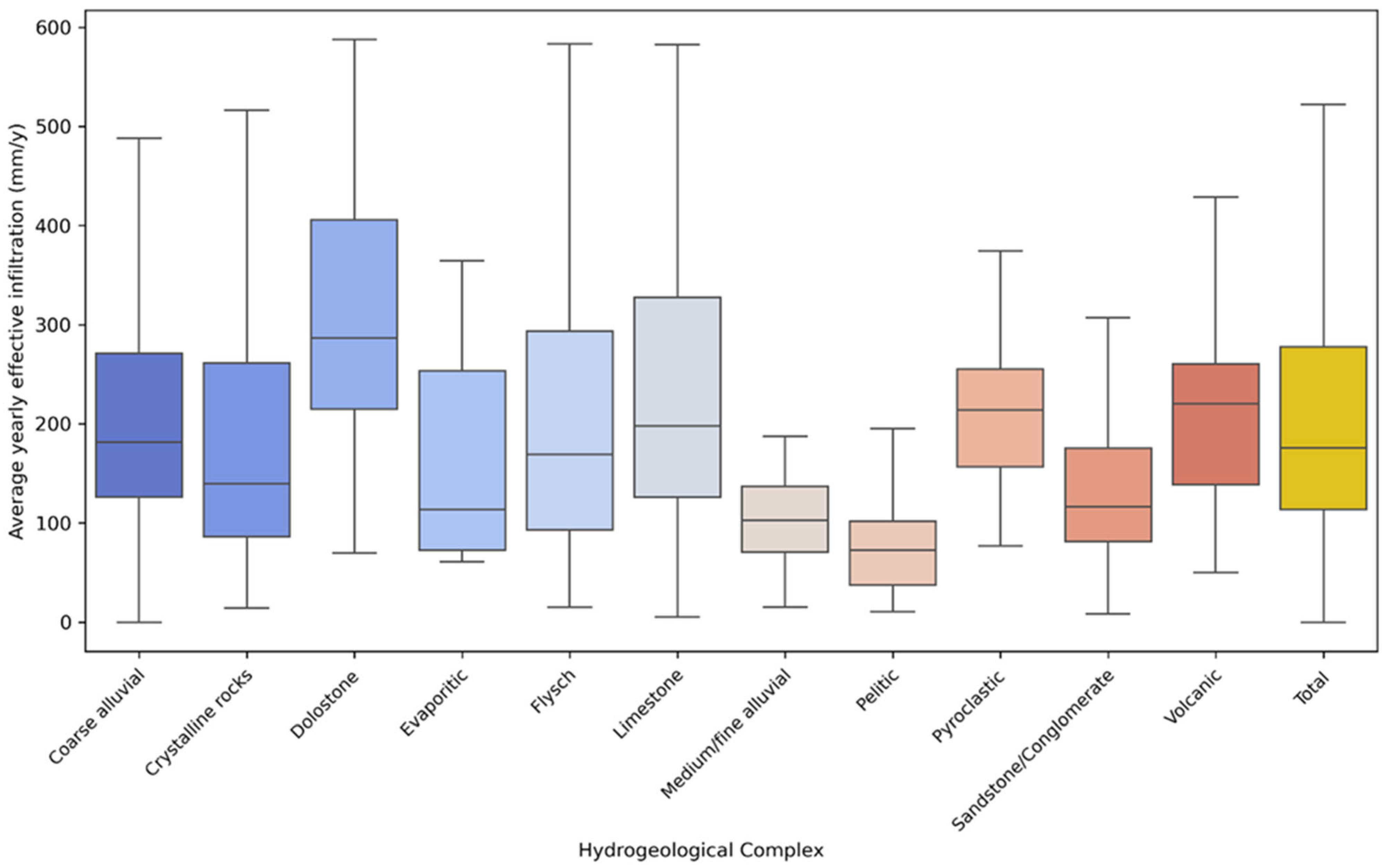
  • Average yearly effective infiltration of the quarry area, derived from the “BIGBANG 4.0” model [32], which determines the water balance equation for the entire Italian territory, using 1 km2 grid cells and considering the annual average precipitation and evapotranspiration data from 1951 to 2019;
  • Water table depth, representing the vertical distance from the quarry floor or natural ground surface to the saturated zone. This parameter was determined by integrating the ISPRA national borehole dataset [33], providing information on wells and boreholes deeper than 30 m, the Regional Water Protection Plans, detailing wells and springs, and available hydrogeological maps supporting the PRAEs or developed at a regional scale;
  • Distance of each quarry from surface water bodies, derived from the national hydrographic network [34].

3. Results

3.1. The European, National, and Regional Regulatory Framework

3.1.1. EU Legislative Acts

The relevant EU legislative acts for this study are listed in Table 1. They mainly consist of directives, i.e., legal instruments that mandate member states to achieve specific objectives while granting them flexibility in determining how to do so. The directives’ goals must be incorporated into one or more national laws, whether newly enacted or amendments to previous laws. Specific references to mining activities are limited, but guidelines on the protection and safeguarding of groundwater are provided in several directives.
The concepts of protection of all water bodies, including groundwater, prevention of their degradation and promotion of sustainable water use are found in Directive 2000/60/EC [35]. Specific reference to extractive industries is contained in Directive 2006/21/EC [36], which gives directions for waste management to avoid risks to human health and prevent environmental impacts. Key concepts include the definition of water damage, which entails any adverse effect on the ecological, chemical, or quantitative state of water bodies. Moreover, specific measures to prevent and control groundwater pollution and criteria for assessing the good chemical status of groundwater are provided. Further references to preventing and controlling groundwater pollution, and specifically to criteria for assessing the good chemical status of groundwater, are contained in Directive 2006/118/EC [37]. Other directives concern Strategic Environmental Assessment (SEA) and Environmental Impact Assessment (EIA) (Directive 2001/42 and Directive 2011/92) [38,39] which apply to projects and constitute a systematic process for evaluating environmental implications and consequences, including those related to groundwater, prior to the decision to move forward with the proposed action. In 2022, the European Parliament [40] adopted a resolution that reaffirms the recognition of access to safe drinking water and sanitation services as fundamental human rights, also highlighting the negative impact of development models focused on large-scale projects and commercial activities on water resources.

3.1.2. National Regulations

In Italy, mining legislation at the national level is still based on Royal Decree 1443/1927 [41]. The decree does not contain any environmental protection regulations, given the historical development phase of the nation, which demanded significant extraction of materials for the construction of cities and infrastructure. The Presidential Decree 128/1959 [42] contains rules and regulations that prioritize worker safety and responsible management of state-owned mineral resources, and environmental protection measures. In 1972, Presidential Decree 2/1972 [43] started the reallocation of administrative responsibilities concerning mining and quarrying from central and peripheral state authorities to ordinary statute regions, which were granted concessions for exploration, research, and the exploitation of resources.
The Legislative Decree 152/2006 [44] serves as the main environmental regulatory framework. It aims to enhance human quality of life by protecting the environment while promoting responsible and sustainable use of natural resources. The decree regulates the procedures for Strategic Environmental Assessment (SEA), Environmental Impact Assessment (EIA), soil protection, water pollution prevention and management of water resources, waste management and remediation of contaminated sites, and compensatory measures for environmental damage. Additionally, the decree also regulates the Basin Authorities, a joint body established between the State and the Regions, operating on river basins considered as unitary systems for soil protection, water remediation, and the use and management of water resources. Environmental monitoring responsibilities, related also to extractive activities, are generally delegated to the Regional Environmental Protection Agencies (ARPAs), to ensure compliance with EIA, while the regions maintain the supervisory role in the field of worker safety and health protection. Environmental control activities assigned to ARPAs include verifying compliance with current regulations through sampling, analysis, measurement, monitoring, inspection of potential risk factors and impacts to assess the status of environmental components.
The Legislative Decree 117/2008 [45] implements the measures and procedures to prevent or minimize negative environmental impacts, particularly on water, air, soil, wildlife, plant life, and landscapes, as well as risks to human health related to extractive industries waste management, as stated by EU Directive 2006/21/EC [36]. Specifically, it stated that the use of extraction waste to fill voids from surface or underground mining is allowed only if the waste stability is ensured, pollution of soil and water is prevented, and monitoring of waste and voids is conducted. The Legislative Decree 30/2009 [46] focuses on the protection and management of groundwater and surface water, where the minimum environmental quality standards are set, aiming to safeguard significant water bodies and to maintain or achieve “good” status for both surface and groundwater. Competent authorities must implement stricter measures than those already provided by existing legislation to address significant risks to aquatic and terrestrial ecosystems, as well as to human health. Measures adopted to achieve quality objectives must be included in river basin management plans and are subject to review every six years, ensuring ongoing monitoring and the adjustment of strategies based on results.

3.1.3. Regional Regulations

Since the 1970s, constitutional principles promoting local autonomy have significantly reshaped the relationship between the State and the Regions, and also in the mining and quarrying sector. National regulations provide a series of tools that local public institutions can use to manage extractive activities in their territory. Regions have legislated on extractive matters at different times, with different approaches to regulating the exploitation of natural resources and addressing related environmental issues. The main regulatory instrument currently adopted at the regional level is a planning system that involves the drafting of Regional Plans for Extractive Activities (PRAE), aimed at establishing guidelines and objectives for the management of quarries, peat bogs, and the reclamation of excavated areas.
The PRAE incorporates the programming of the extractive activities within territorial planning and can also assign to the provinces the task of developing Provincial Extractive Activity Plans (PPAE). The municipalities are required to adapt their urban planning tools to align with the contents of the provincial plan, to ensure coordinated land and resource management. The regional and provincial extractive planning is based on several key factors, including the material demand, the location and quantity of geomaterials, the characteristics of the territory, and existing territorial plans. The plans (PRAEs and PPAEs) identify the areas where extractive activities are planned, defining specific territorial zones for quarries, including those reserved for public works and recovery. The main requirements and obligations are also established, such as the maximum volume of extractable geomaterials, the types of extraction (above- or below-water table), the maximum depths of excavations, the final destination of the areas after environmental recovery, and the possible presence of constraints or prescriptions. The plans also include technical regulations (NTA) that provide detailed rules for quarrying and for the environmental safety and restoration of the affected areas.
Table 2 shows the main contents of the PRAEs for the Italian regions and some examples of PPAEs (in the case of the adoption of provincial plans), with specific reference to the following technical standards concerning water resources:
  • Reference reports: geological and hydrogeological studies of the excavation area to manage aquifers and watercourses, and to obtain the operating license;
  • Monitoring wells and piezometers: protocols specifying placement, technical specifications, and hydrogeological monitoring methods, along with regulations for extraction below the water table and preventing interactions between shallow and deeper aquifers;
  • Groundwater protection: runoff management to prevent contamination of water resources and to mitigate erosion and flood risks;
  • Water runoff: regulations aimed at reducing water infiltration on the quarry site and preventing groundwater contamination;
  • Water infiltration: protocols for groundwater and surface water monitoring plans near extraction sites;
  • Monitoring plan: required assessment for the protection of water resources in karst and carbonate environments;
  • Karst areas: required assessment for the protection of water resources in karst and carbonate environments;
  • Reclamation: requirements for environmental reclamation ensuring morphological restoration, water resource protection, and erosion prevention.
In a few cases, guidelines for monitoring and controlling extractive activities on groundwater are available. An example in this respect was produced by ARPAT (the Environment Agency of the Tuscany Region) [47] and the main aspects considered are summarized in Table 3.

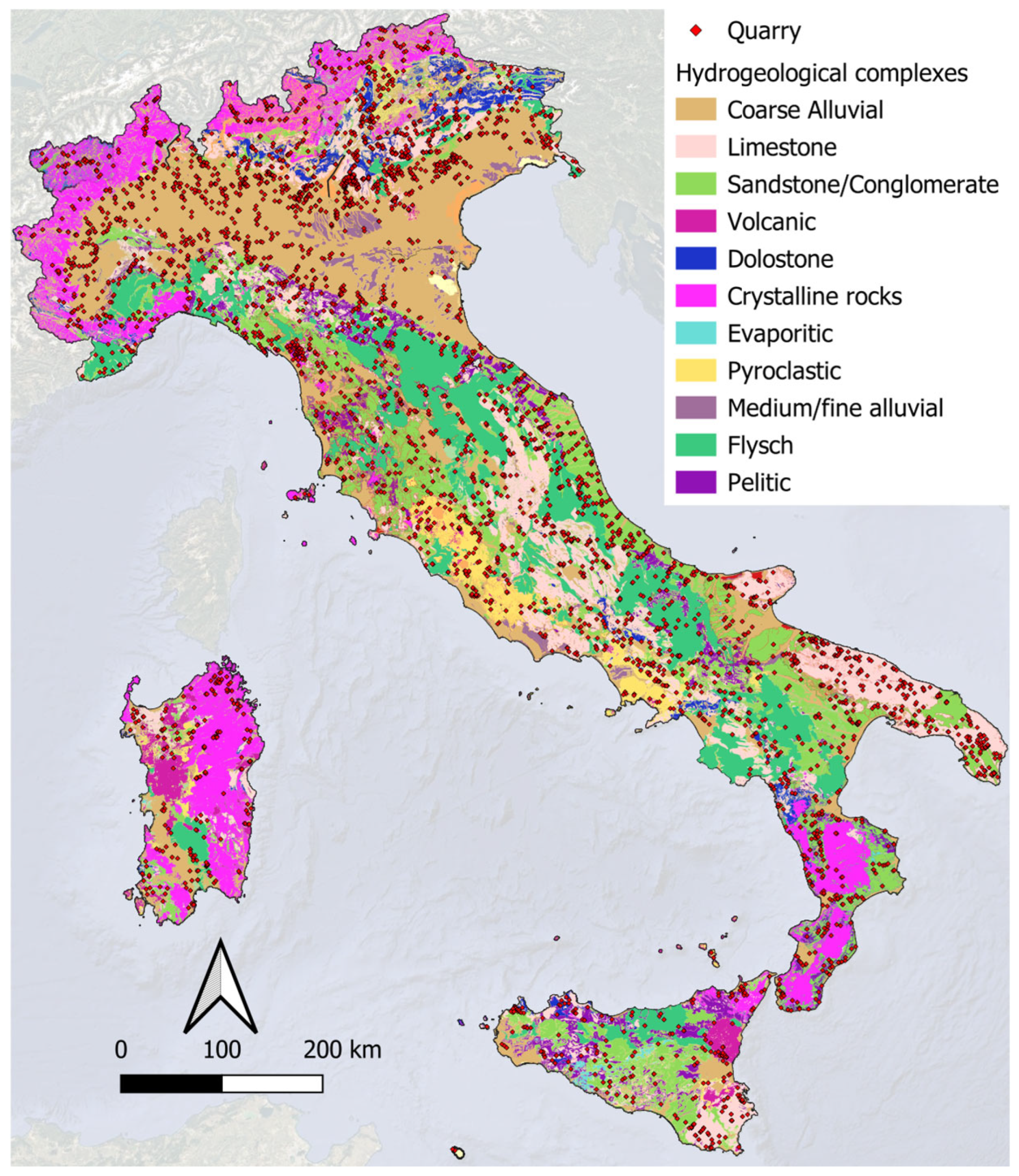
3.2. The Panorama of Quarrying in Italy with Reference to Hydrogeological Conditions
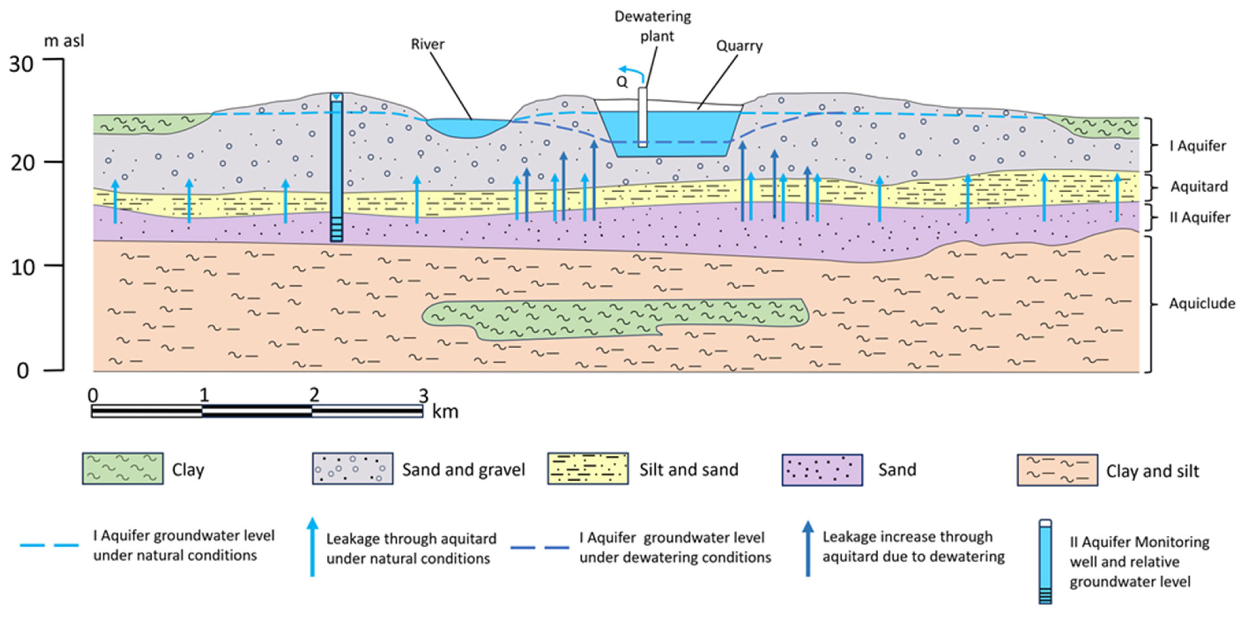
There are 4043 quarries active in Italy with a heterogeneous distribution across the national territory. The percentage of the territory of the Italian provinces covered by quarry sites generally varies from 0.10 to 0.75% (Figure 1). Quarrying activities produce around 68.75 million m3 of geomaterials per year [48] including sands and gravels extracted from alluvial plains (42.5% of total volume extracted), limestones (39.0%), ornamental stones (9.0%), secondary clay (5.2%), volcanic and pyroclastic rocks (4.2%), and peat (0.1%).
A more functional quarry classification was developed based on their specific hydrogeological characteristics and their location within hydrogeological complexes. These complexes were derived from the Hydrogeological Map of Italy [31,49]. Figure 2 shows the spatial distribution of the quarries overlaid on the map of hydrogeological complexes.
In Table 4, the quarries have been analyzed in the light of their belonging to different hydrogeological complexes, showing the statistics of the surface area for each complex.
A significant percentage of quarries are situated in coarse alluvial complexes (about 46%) and limestone complexes (about 24%), while in the other hydrogeological complexes, the presence of quarries does not exceed 8%. In most cases (between the 25th and the 75th percentile) the surface extensions of the quarries range from 2 to 13 ha when considering the entire dataset. Quarries covering large areas extend over the coarse alluvial and limestone complexes up to a maximum of 300 and 440 ha, respectively. The largest surface areas are located in the Apuan Alps, where marble is widely quarried from a crystalline complex. The total area covered by quarries in Italy is approximately 500 km2, equivalent to 0.17% of the land area of Italy.
Other parameters considered to assess the impact of quarries on groundwater include effective infiltration and groundwater level depth in extractive areas. Specifically, the model’s annual average effective infiltration values—between the 25th and 75th percentile—have been considered, excluding maximum values, which in some areas of the Eastern Alps have been estimated at more than 1500 mm/year and are considered overestimated when compared with regional hydrological water budgets [50]. As shown in Figure 3, the most represented values for all quarries (i.e., those between the 25th and the 75th percentile) vary from 118 and 306 mm/year. Higher values are observed in the quarries of limestone and dolostone complexes due to their location at higher altitudes compared to other categories (Figure 3).
Five classes of groundwater level depth were considered based on the estimated pollutant travel time from the soil surface to the water-table. As shown in Table 5, taking the entire dataset into account, about 62% of the quarries are in areas with groundwater level depths over 20 m. Among the quarries most vulnerable based on this factor are those falling into the coarse alluvial complex, with about 42% of them characterized by a depth of the groundwater level of 8 m or less.
From the analysis of the data, it is clear that the quarries located in coarse alluvial and limestone complexes are the most widespread and have a higher potential impact on groundwater, being characterized by a significant combination of area extension, depth of groundwater level and effective infiltration rates. These two hydrogeological complexes also have higher transmissivity, lower hydraulic gradients and higher groundwater yields [51].
In addition, to highlight the possible relationships between groundwater and surface water, Table 6 shows the distribution of quarry distances from surface water bodies across the different hydrogeological complexes.
Overall, 19% of all quarries are located within 50 m of surface water bodies. Notably, quarries located in the coarse alluvial complex, which show a higher potential for impacting groundwater—surface water equilibrium, with approximately 32% of these located less than 50 m from surface water bodies.

4. Discussion

The European directives provide general guidelines for protecting water resources in the industrial sector, but there are few specific technical requirements for extractive areas. However, these directives encourage the adoption of national legislation, by introducing key tools such as the SEA and EIA, which have been implemented by European countries in different ways and times, including for quarrying activities. Both procedures aim to promote sustainable development but differ in scope and objectives. The SEA focuses on plans and programs, analyzing environmental impacts from a broad and strategic perspective, often at a national, regional, or local scale. In Italy, one example includes the Basin Plans of competent authorities, established to protect water resources in response to European directives, or the PRAEs. The EIA instead aims to ensure that human activities and projects are compatible with sustainable development principles. This involves respecting the regenerative capacity of ecosystems and resources, preserving biodiversity, and ensuring a fair distribution of benefits related to economic activities. Extractive activities are among those that require an EIA before the operations can begin. The guidelines for drafting the Environmental Monitoring Project for groundwater resources are divided into quantitative, quality, and additional procedures. These focus on different stages of development throughout the operational and closure phase and establish a set of requests about the monitoring of multiple water bodies, including groundwater [52].
The investigation phase and the initial project phase of extractive activities, via the submission of project documents, including the EIA, are relatively straightforward within the context of the mining industry. The challenge arises during the operational and reclamation phase, the most critical in terms of potential environmental impact, because equilibrium conditions can be permanently altered [4,53,54,55]. During the operational phase, adequate quantitative and qualitative analysis is required to assess water resource alterations. Although the competent authority can be identified, the interpretation of the outcomes of monitoring activities, especially in extractive operations, are often unclear. Several reports assessed the EIA efficiency [56,57,58], noting a delay in directive implementation and highlighting a significant heterogeneity in the thresholds of various natural parameters. It is also difficult to estimate how this procedure impacts the design of new projects and how the quality of the data used in the EIAs was assessed. The directive lacks provisions regarding reasonable and preferably fixed timelines for issuing the authorization, the duration of the EIA validity, and the monitoring of significant environmental effects resulting from project implementation [59].
The main goal of the PRAEs is to establish effective regional management to assess the volumetric availability of extractive materials, provide an overview of the development of the extractive industry, and implement restrictions and technical standards (NTA) to ensure minimal environmental impact. A recent study [60] demonstrated the potential of Piedmont region PRAE to assess the status of the extractive activities and their implication on groundwater resources, and to identify the connection with other water management plans. However, the regional regulatory framework appears to be heterogeneous and fragmented. While some regions show relatively rapid approval and renewal of their plans, particularly when compared to the legislative transition of responsibilities from the national to the regional/provincial level, other regions lack a plan altogether. In these regions, extractive activities are regulated by outdated regional laws that no longer meet the sustainability criteria required in recent years. It is only in a few cases that the decision-makers implemented effective updates capable of integrating the extractive sector with the complexity of evolving environmental regulations and addressing all the extractive phases of a quarry life cycle. Table 2 illustrates that regions lacking a PRAE, where only a reference report is required, exhibit a greater deficiency in regulations. For instance, only nine regions require extractive activities to install monitoring wells to assess the impact of extraction, and many do not mandate a water quality monitoring plan. The monitoring program should include observation wells installed outside the excavation area to monitor groundwater level and quality. While not all guidelines specify the position, best practices should demand at least one observation well downstream and one upstream of the quarry. Few cases are virtuous in relation to the aspects to be considered for mitigating the impact of quarries on groundwater (for example, ARPAT in Tuscany Region). Moreover, the absence of national databases on quarries and their hydrogeological context is detrimental to data transparency and for assessing monitoring capabilities. The lack of uniform guidelines across the regions is significantly evident and can lead to various approaches, often resulting in procedural gaps that may be harmful in terms of environmental concerns. Harmonization of nationwide guidelines can be useful to simplify the development process of extractive activities and the selection of control methods.
Another unaddressed aspect concerns the dewatering operations. In the PRAE documentation, with a few exceptions or in a general preparatory hydrogeological assessment, no requirement nor recommendation is made whether dewatering is to be applied. In other countries, such as the United Kingdom and Germany [61,62], dewatering permission is required, and the relevant regulatory bodies should be consulted to acquire permission for pumping, and a model of taxation based on the quantity of water abstracted is applied. This is a very important aspect, as dewatering, particularly in highly transmissive aquifers, can impact both groundwater quantity and quality at significant distances from the quarrying site.
The regulatory framework could be improved by considering the distribution of quarries in the Italian hydrogeological context. Based on the total surface of the quarries and the average and 75th percentile value of mean effective infiltration rate in those areas, the estimated groundwater resources within the quarry areas range from 120 to 153 million m3 per year, representing 0.18–0.24% of Italy’s groundwater resources [32]. While this represents a relatively small percentage of groundwater (which can increase considerably if drainage is practiced), these are high-quality groundwater resources, widely used for drinking water supply, and essential for groundwater-dependent ecosystems. Therefore, adapting the standards and safeguarding criteria throughout the whole quarry life cycle is certainly a preventive element also to reduce the costs of remediation in case of impacts on the quality and quantity of groundwater. For this purpose, progressively more stringent standards could be adopted, also referring to the cases of virtuous regions, taking into account two important parameters, such as the extension of the quarry area and the depth of the groundwater level concerning the excavation plan. These two parameters are fundamental for the following:
  • determining the depth of the hydrogeological investigations in the design and exploitation phase of the quarry;
  • defining the number and location of observation wells, as well as the frequency of sampling, for monitoring the quality and quantity of groundwater;
  • establishing the strictness of the groundwater safeguarding systems during exploitation and post-exploitation;
  • mandating flow and contaminant transport modeling to predict the most probable scenarios of the impact of the quarry on groundwater.
While these activities will inevitably impact project costs, a sufficiently large quarry with a shallow groundwater table may potentially offset environmental costs through mining revenues.
In the Italian hydrogeological context of quarrying, two cases appear to be the most vulnerable for groundwater: the quarries in the alluvial coarse and limestone hydrogeological complexes, due to their wide territorial spread and the inherent hydrogeological fragility of the two complexes.
As schematized in Figure 4, quarries hosted in a coarse alluvial complex are characterized by a highly heterogeneous subsoil. The stratigraphic succession typical of alluvial plains usually has multilayered high-transmissivity aquifers alternating with aquitards and aquicludes showing complex geometries, developing a vertical groundwater exchange among the aquifer layers, especially when dewatering processes are activated. Additionally, in alluvial plains, the low surface slope allows high infiltration rates, the depth of the water table of the shallowest aquifer is reduced, and interactions between groundwater and surface water occur.
In this hydrogeological environment, the key factors to mitigate the impacts of quarrying on groundwater are a thorough understanding of the hydrostratigraphy of the quarry site, the transmissivity of overlapping aquifers, the hydraulic conductivity and continuity of aquitards and aquicludes, and the surface water-groundwater relationships. Due to the considerable transmissivity of the coarse alluvial layers (higher than 10−3 m2/s) and the low hydraulic gradient (a few units per thousand), any impact on groundwater caused by quarries can spread over considerable distances beyond the extraction site. Therefore, any system of safeguarding, monitoring, and drainage of the quarry area must be designed according to these key factors, also taking into account both the extent of the quarry area and the expected depth of excavation.
Another hydrogeological complex in which quarries are widespread in Italy is the limestone complex (Figure 5). In this case (and similarly for marble quarries, included in the crystalline hydrogeological complex), a new approach is necessary to better integrate normative provisions with the hydrogeological specificity of the complex. The limestone complex generates important aquifers characterized by a high permeability, significant aquifer thicknesses, and meaningful recharge being mostly located at high altitudes (at least regarding the Apennines and the Alps) [51,63,64]. These formations feature the presence of a developed network of discontinuities and karstic conduits, of aquitards interspersed in the carbonate stratigraphic successions, of faults and thrust faults determining a highly articulated pattern of groundwater circuits. This results in an extensive and continuous basal groundwater circulation, even if divided into separate reservoirs (identifiable based on structural geology) and perched aquifers displaced at higher altitudes.
In this case, to mitigate the impacts of quarrying on groundwater it is necessary to take into account the following:
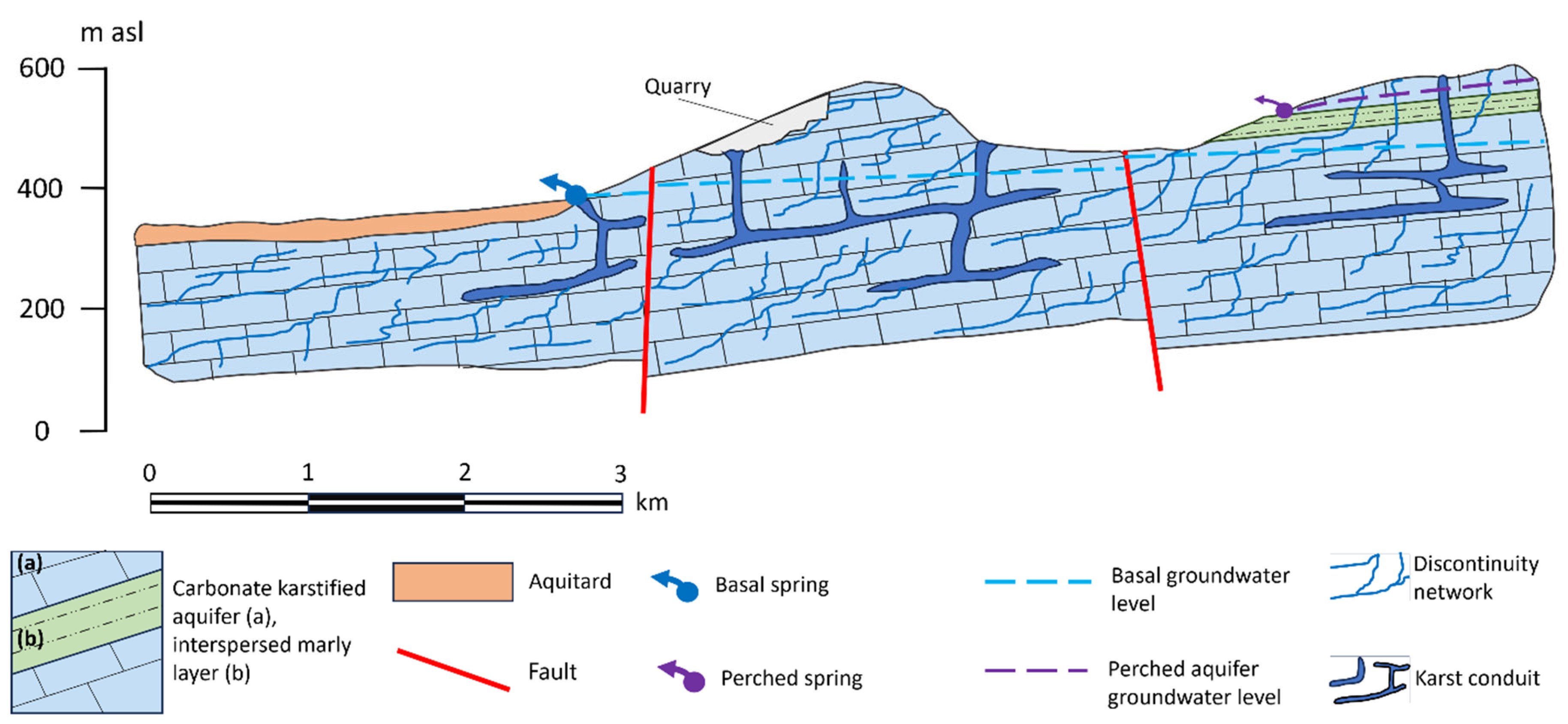
  • the altitude of the quarry compared with the hydraulic head of the basal groundwater circulation and therefore the location of the associated springs;
  • the groundwater drainage systems differentiate between diffuse flow in the fracture network and flow within the karst conduits;
  • the unsaturated zone properties, which determine recharge through diffuse infiltration of precipitation, concentrated secondary infiltration of surface runoff through sinkholes and joints, and karst drainage system in the epikarst;
  • the hydraulic heterogeneity of the aquifer due to triple porosity (matrix, fracture, and conduit), which determines the velocity and amount of groundwater transmitted and stored in the aquifer and consequently the high vulnerability to contamination and its persistence.
These main peculiarities of the carbonate and karstic aquifers differentiate them from other types of aquifers, particularly due to their extreme heterogeneity and anisotropy, regime of flow under both laminar and turbulent conditions, and level and chemistry temporal variations [65]. It follows that any system of safeguarding, monitoring, and drainage in quarry area implies in-depth knowledge of aquifer boundaries and preferential flow paths within the network of fractures and conduits. Therefore, regulations should impose in the quarry planning phase more detailed investigation, such as hydrogeological mapping, surface geophysics, well hydraulic tests, water-tracing tests, natural tracers, well and spring hydrograph analysis, and chemigraphic analysis [66,67,68]. The higher costs required for designing, surveying, and monitoring quarries in limestone hydrogeological complex are justified by the high groundwater yield, which provides excellent quality for drinking use, and the more challenging and costly methods to remediate groundwater contamination compared to other types of aquifers.

5. Conclusions

The regulatory framework and technical standards currently in force in Italy concerning the potential impacts of quarries on groundwater, at both national and regional levels, appear to be inadequate in light of the distribution, size, and characteristics of quarrying sites within the national hydrogeological context. Regional management of quarry projects shows significant variability and is often ineffective with regard to the design, operational, and post-closure phases. Achieving groundwater sustainability in quarrying requires enhanced harmonization of standards at the regional level. While preserving regional autonomy, these standards should be uniformly coordinated and monitored at the national level. This would enhance transparency and improve public relations with stakeholders, institutions and the general public, thereby addressing the widespread misconception regarding the negative environmental impact of quarrying. A tiered system of technical standards, including more detailed investigations and a comprehensive monitoring and protection framework, could be developed based on key parameters identified in this study. Notably, the quarry’s size and the depth of the groundwater level for each excavation plan should serve as primary indicators for groundwater protection measures and, consequently, for the costs associated with surveys, monitoring and safeguards systems. A further consideration, applying—not exclusively—to the Italian situation, is the quarry’s hydrogeological context, which determines its vulnerability to alteration of hydrodynamic equilibrium and contamination. This study identifies alluvial aquifers and carbonate-karstified aquifers as the most vulnerable, necessitating particular attention due to their hydrogeological features and groundwater yield. Regulations and technical standards should be tailored to reflect the different recharge, flow, and discharge patterns of these two aquifer types. Furthermore, the specific hydrological properties of other aquifer types should always guide quarrying sustainability practices. Integration of specific regulations for dewatering activities into current legislation is necessary. Especially in high-transmissivity aquifers, such as alluvial and carbonate and/or karstified aquifers, the impact of groundwater withdrawals can profoundly alter local hydrogeological equilibrium, as well as dependent ecosystems.

Funding

This project was supported by a grant from PNRR “Geosciences IR” (Missione 4 “Istruzione e Ricerca”—Componente 2 “Dalla ricerca all’impresa”—Linea di investimento 3.1, “Fondo per la realizzazione di un Sistema integrato di infrastrutture di ricerca e innovazione” Financed by European Union NextGenerationEU—CUP I53C22000800006). This manuscript reflects only the author’ views and opinions; neither the European Union nor the European Commission can be considered responsible for them.

Data Availability Statement

The data presented in this study are available on request from the corresponding author (accurately indicate status).

Acknowledgments

The author would like to gratefully thank Vincenzo Piscopo for the critical review, Chiara Sbarbati for her support, and Sandra D’Avenio for her assistance with English revision. The author would also thank the editor and the reviewers for their comments which improve the quality of the manuscript.

Conflicts of Interest

The author declares no conflict of interest. The funders had no role in the design of the study; in the collection, analyses, or interpretation of data; in the writing of the manuscript; or in the decision to publish the results.

References

  1. Eurostat. Businesses in the Mining and Quarrying Sector. 2025. Available online: https://ec.europa.eu/eurostat/statistics-explained/SEPDF/cache/10085.pdf (accessed on 7 March 2025).
  2. Bendixen, M.; Iversen, L.L.; Best, J.; Franks, D.M.; Hackney, C.R.; Latrubesse, E.M.; Tusting, L.S. Sand, Gravel, and UN Sustainable Development Goals: Conflicts, Synergies, and Pathways Forward. One Earth 2021, 4, 1095–1111. [Google Scholar] [CrossRef]
  3. Schoderer, M.; Ott, M. Contested Water- and Miningscapes—Explaining the High Intensity of Water and Mining Conflicts in a Meta-Study. World Dev. 2022, 154, 105888. [Google Scholar] [CrossRef]
  4. Green, J.A.; Pavlish, J.A.; Merritt, R.G.; Leete, J.L. Hydraulic Impacts of Quarries and Gravel Pits; Legislative Commission on Minnesota Resources: Saint Paul, MN, USA, 2005; Available online: https://files.dnr.state.mn.us/publications/waters/hdraulic-impacts-of-quarries.pdf (accessed on 7 March 2025).
  5. Darwish, T.; Khater, C.; Jomaa, I.; Stehouwer, R.; Shaban, A.; Hamzé, M. Environmental impact of quarries on natural resources in Lebanon. Land Degrad. Dev. 2011, 22, 345–358. [Google Scholar] [CrossRef]
  6. Misra, A.K. Influence of stone quarries on groundwater quality and health in Fatehpur Sikri, India. Int. J. Sustain. Built Environ. 2013, 2, 73–88. [Google Scholar] [CrossRef]
  7. Newman, C.; Agioutantis, Z.; Jimenez Leon, G.B. Assessment of potential impacts to surface and subsurface water bodies due to longwall mining. Int. J. Min. Sci. Technol. 2017, 27, 57–64. [Google Scholar] [CrossRef]
  8. Kefeni, K.K.; Msagati, T.A.M.; Mamba, B.B. Acid mine drainage: Prevention, treatment options, and resource recovery: A review. J. Clean. Prod. 2017, 151, 475–493. [Google Scholar] [CrossRef]
  9. Addison, T.; Roe, A. Extractive Industries: The Management of Resources as a Driver of Sustainable Development; Oxford University Press: Oxford, UK, 2018. [Google Scholar] [CrossRef]
  10. Piccini, L.; Di Lorenzo, T.; Costagliola, P.; Galassi, D.M.P. Marble slurry’s impact on groundwater: The case study of the Apuan Alps karst aquifers. Water 2019, 11, 2462. [Google Scholar] [CrossRef]
  11. Dubois, C.; Goderniaux, P.; Deceuster, J.; Poulain, A.; Kaufmann, O. Hydrogeological characterization and modelling of weathered karst aquifers. Environ. Earth Sci. 2019, 78, 99. [Google Scholar] [CrossRef]
  12. Huang, W.; Sui, L.; Wang, Y.; Zhang, C.; Jiang, D.; Cai, X.; Yang, Z. Study of the mining and aquifer interactions in complex geological conditions and its management. Sci. Rep. 2023, 13, 9462. [Google Scholar] [CrossRef]
  13. Wolkersdorfer, C.; Mugova, E. Effects of Mining on Surface Water. In Encyclopedia of Inland Waters; Mehner, T., Tockner, K., Eds.; Elsevier: Amsterdam, The Netherlands, 2022; pp. 170–188. [Google Scholar] [CrossRef]
  14. Piscopo, V.; Sbarbati, C.; Lotti, F.; Lana, L.; Petitta, M. Sustainability indicators of groundwater withdrawal in a heavily stressed system: The case of the Acque Albule Basin (Rome, Italy). Sustainability 2022, 14, 15248. [Google Scholar] [CrossRef]
  15. Piscopo, V.; Sbarbati, C.; Sebestyén, Z.; Varga, Z. Combining groundwater and game-theoretical models for determining the sustainable yield in a heavily stressed aquifer system. J. Hydrol. 2024, 633, 130965. [Google Scholar] [CrossRef]
  16. Tomiyama, S.; Igarashi, T. The potential threat of mine drainage to groundwater resources. Curr. Opin. Environ. Sci. Health 2022, 27, 100347. [Google Scholar] [CrossRef]
  17. Levy, M.A. Is the environment a national security issue? Int. Secur. 1995, 20, 35–62. [Google Scholar] [CrossRef]
  18. Anderson, B.; Berry, D.; Shields, D. Sustainable Development and Its Influence on Mining Operations on Federal Lands: A Conversation in Plain Language; U.S. Bureau of Land Management: Washington, DC, USA, 2002; Available online: https://archive.org/details/sustainabledevelunit (accessed on 7 March 2025).
  19. Sigam, C.; Garcia, L. Extractive Industries: Optimizing Value Retention in Host Countries; UNCTAD: Geneva, Switzerland, 2012; Available online: https://unctad.org/system/files/official-document/suc2012d1_en.pdf (accessed on 7 March 2025).
  20. Admiraal, R.; Sequeira, A.R.; McHenry, M.P.; Doepel, D. Maximizing the impact of mining investment in water infrastructure for local communities. Extr. Ind. Soc. 2017, 4, 240–250. [Google Scholar] [CrossRef]
  21. De Sa, P. Mining and sustainable development: Territorializing the mining industry. Miner. Econ. 2019, 32, 131–143. [Google Scholar] [CrossRef]
  22. UNEP. Mineral Resource Governance in the 21st Century: Gearing Extractive Industries Towards Sustainable Development; United Nations: New York, NY, USA, 2020. [Google Scholar] [CrossRef]
  23. Monteiro, N.B.R.; Bezerra, A.K.L.; Moita Neto, J.M.; Silva, E.A.d. Mining Law: In Search of Sustainable Mining. Sustainability 2021, 13, 867. [Google Scholar] [CrossRef]
  24. ISTAT. Attività Estrattive da Cave e Miniere. Anni 2015, 2016; Istituto Nazionale di Statistica: Rome, Italy, 2019; Available online: https://www.istat.it/it/files/2019/01/Report_Attivit%C3%A0_estrattive_2015-2016.pdf (accessed on 7 March 2025).
  25. Auci, S.; Vignani, D. Mines and quarries production: A driver analysis of withdrawals in Italy. Resour. Policy 2020, 67, 101657. [Google Scholar] [CrossRef]
  26. Paoletti, M.; Piscopo, V.; Sbarbati, C.; Scarelli, A. Categorization of the potential impact of Italian quarries on water resources through a multi-criteria decision aiding-based model. Sustainability 2024, 16, 2804. [Google Scholar] [CrossRef]
  27. Lee, C.; Asbjörnsson, G.; Hulthén, E.; Evertsson, M. The Environmental Impact of Extraction: A Holistic Review of the Quarry Lifecycle. Clean. Environ. Syst. 2024, 13, 100201. [Google Scholar] [CrossRef]
  28. ISTAT. Attività Estrattive da Cave e Miniere. Anno 2018; Istituto Nazionale di Statistica: Rome, Italy, 2020; Available online: https://www.istat.it/it/archivio/246015 (accessed on 7 March 2025).
  29. Copernicus Land Monitoring Service. CORINE Land Cover 2018; EEA: Copenhagen, Denmark, 2020; Available online: https://land.copernicus.eu/en/products/corine-land-cover (accessed on 7 March 2025).
  30. ISPRA. Carta Uso del Suolo 2022; Istituto Superiore per la Protezione e la Ricerca Ambientale: Rome, Italy, 2023; Available online: https://groupware.sinanet.isprambiente.it/uso-copertura-e-consumo-di-suolo/library/copertura-del-suolo/carta-di-copertura-del-suolo/uso-del-suolo-2022 (accessed on 7 March 2025).
  31. Gafà, R.M.; Martarelli, L.; Monti, G.; Silvi, A.; La Vigna, F. Preliminary elaboration of a permeability map of Italy starting from the information of the lithological map of Italy. Acque Sotter. Ital. J. Groundw. 2019, 8, 75–77. [Google Scholar] [CrossRef]
  32. Braca, G.; Bussettini, M.; Lastoria, B.; Mariani, S.; Piva, F. Il Bilancio Idrologico GIS Based a Scala Nazionale su Griglia Regolare–BIGBANG: Metodologia e Stime; ISPRA: Rome, Italy, 2021. Available online: https://www.isprambiente.gov.it/it/pubblicazioni/rapporti/il-bilancio-idrologico-gis-based-a-scala-nazionale-su-griglia-regolare-bigbang (accessed on 8 March 2025).
  33. ISPRA. Dati Geognostici e Geofisici–Archivio Indagini nel Sottosuolo (Legge 464/84); Istituto Superiore per la Protezione e la Ricerca Ambientale: Rome, Italy, 2025. Available online: https://www.isprambiente.gov.it/it/banche-dati/banche-dati-folder/suolo-e-territorio/dati-geognostici-e-geofisici (accessed on 7 March 2025).
  34. Ministero Dell’ambiente e Della Sicurezza Energetica (MASE). Geoportale Nazionale. Reticolo Idrografico. Available online: http://wms.pcn.minambiente.it/ogc?map=/ms_ogc/wfs/Aste_fluviali.map (accessed on 7 March 2025).
  35. European Parliament and Council. Directive 2000/60/EC. 2000. Available online: https://eur-lex.europa.eu/eli/dir/2000/60/oj/eng (accessed on 7 March 2025).
  36. European Parliament and Council. Directive 2006/21/EC. 2006. Available online: https://eur-lex.europa.eu/legal-content/EN/TXT/HTML/?uri=CELEX:32006L0021 (accessed on 7 March 2025).
  37. European Parliament and Council. Directive 2006/118/EC. 2006. Available online: https://eur-lex.europa.eu/legal-content/EN/LSU/?uri=CELEX%3A32006L0118 (accessed on 7 March 2025).
  38. European Parliament and Council. Directive 2001/42/EC. 2001. Available online: https://eur-lex.europa.eu/legal-content/EN/TXT/?qid=1714957499848&uri=CELEX%3A32001L0042 (accessed on 7 March 2025).
  39. European Parliament and Council. Directive 2011/92/EU. 2011. Available online: https://eur-lex.europa.eu/legal-content/EN/TXT/?uri=celex%3A32011L0092 (accessed on 7 March 2025).
  40. European Parliament. Resolution on Access to Water as a Human Right–The External Dimension. 2022. Available online: https://www.europarl.europa.eu/doceo/document/TA-9-2022-0346_EN.html (accessed on 7 March 2025).
  41. Ministero delle Imprese e del Made in Italy (MIMIT). Regio Decreto 29 luglio 1927, n. 1443 “Norme di Carattere Legislativo per Disciplinare la Ricerca e la Coltivazione delle Miniere nel Regno”. Available online: https://www.mimit.gov.it/images/stories/energia/1443rd27.pdf (accessed on 8 March 2025).
  42. Decreto del Presidente Della Repubblica 9 Aprile 1959, n. 128. Norme di Polizia delle Miniere e delle Cave. Available online: https://www.normattiva.it/uri-res/N2Ls?urn:nir:presidente.repubblica:decreto:1959-04-09;128 (accessed on 8 March 2025).
  43. Decreto del Presidente della Repubblica 14 Gennaio 1972, n. 2. Trasferimento alle Regioni a Statuto Ordinario delle Funzioni Amministrative Statali in Materia di Acque Minerali e Termali, di Cave e Torbiere e di Artigianato e del Relativo Personale. Available online: https://www.normattiva.it/uri-res/N2Ls?urn:nir:presidente.repubblica:decreto:1972-01-14;2 (accessed on 8 March 2025).
  44. Decreto Legislativo 3 Aprile 2006, n. 152. Norme in Materia Ambientale. Available online: https://www.normattiva.it/uri-res/N2Ls?urn:nir:stato:decreto.legislativo:2006-04-03;152 (accessed on 8 March 2025).
  45. Decreto Legislativo 30 Maggio 2008, n. 117. Attuazione Della Direttiva 2006/21/CE Relativa alla Gestione dei Rifiuti delle Industrie Estrattive e che Modifica la Direttiva 2004/35/CE. Available online: https://www.normattiva.it/uri-res/N2Ls?urn:nir:stato:decreto.legislativo:2008-05-30;117 (accessed on 8 March 2025).
  46. Decreto Legislativo 16 marzo 2009, n. 30. Attuazione Della Direttiva 2006/118/CE, Relativa alla Protezione delle Acque Sotterranee Dall’inquinamento e dal Deterioramento. Available online: https://www.normattiva.it/uri-res/N2Ls?urn:nir:stato:decreto.legislativo:2009-03-16;30 (accessed on 8 March 2025).
  47. ARPAT. Le Componenti Suolo, Sottosuolo e Risorsa Idrica Nella Valutazione Ambientale dell’attività Estrattiva; Agenzia Regionale per la Protezione Ambientale: Florence, Italy, 2010; Available online: https://www.arpat.toscana.it/documentazione/catalogo-pubblicazioni-arpat/le-componenti-suolo-sottosuolo-e-risorsa-idrica-nella-valutazione-ambientale-dell2019attivita-estrattiva (accessed on 7 March 2025).
  48. Legambiente. Rapporto Cave 2021; Legambiente: Rome, Italy, 2021; Available online: https://www.legambiente.it/rapporti-e-osservatori/rapporto-cave-2021/ (accessed on 8 March 2025).
  49. Beretta, G.P.; La Vigna, F.; Camera, C.A.S.; Gafà, R.M.; Citrini, A.; Martarelli, L.; Monti, G.M.; Roma, M.; Silvi, A.; Vitale, V.; et al. Carta Idrogeologica d’Italia alla Scala 1:500.000–4 Fogli, Note Integrative e Tabelle Online–Hydrogeological Map of Italy 1:500,000 Scale. 4 Sheets, Supplementary Notes and Online Tables; ISPRA-Dipartimento per il Servizio Geologico d’Italia-Geological Survey of Italy: Roma, Italy, 2025. Available online: https://www.isprambiente.gov.it/it/attivita/geologia/carta-idrogeologica-italia (accessed on 20 June 2025).
  50. Zini, L.; Calligaris, C.; Treu, F.; Iervolino, D.; Lippi, F. Risorse Idriche Sotterranee del Friuli Venezia Giulia: Sostenibilità Dell’attuale utilizzo; EUT Edizioni Università di Trieste: Trieste, Italy, 2011. [Google Scholar]
  51. Civita, M.V. L’assetto idrogeologico del territorio italiano: Risorse e problematiche. Quad. Soc. Geol. Ital. 2008, 3, 34. [Google Scholar]
  52. Ministero dell’Ambiente e della Sicurezza Energetica (MASE). Linee Guida per la Predisposizione del Progetto di Monitoraggio Ambientale (PMA); Ministero Dell’ambiente e Della Sicurezza Energetica: Rome, Italy, 2014. Available online: https://va.mite.gov.it/it-it/ps/datiestrumenti/specifichetecnicheelineeguida (accessed on 8 March 2025).
  53. Streetly, M. Dewatering and environmental monitoring for the extractive industry. Q. J. Eng. Geol. 1998, 31, 125–127. [Google Scholar] [CrossRef]
  54. Parise, M. A present risk from past activities: Sinkhole occurrence above underground quarries. Carbonates Evaporites 2012, 27, 109–118. [Google Scholar] [CrossRef]
  55. Bozan, C.; Wallis, I.; Cook, P.G.; Dogramaci, S. Groundwater-level recovery following closure of open-pit mines. Hydrogeol. J. 2022, 30, 1819–1832. [Google Scholar] [CrossRef]
  56. European Commission. Report on the Application and Effectiveness of the EIA Directive (Directive 85/337/EEC); Brussels, Belgium, 2003. Available online: https://eur-lex.europa.eu/legal-content/EN/ALL/?uri=CELEX%3A52003DC0334 (accessed on 2 March 2025).
  57. European Commission. Report on the Application and Effectiveness of the EIA Directive (Directive 85/337/EEC, as Amended); Brussels, Belgium, 2009. Available online: https://eur-lex.europa.eu/legal-content/EN/ALL/?uri=CELEX%3A52009DC0378 (accessed on 2 March 2025).
  58. OECD. OECD Economic Surveys: Italy 2011; OECD Publishing: Paris, France, 2011; Available online: https://www.oecd.org/en/publications/oecd-economic-surveys-italy-2011_eco_surveys-ita-2011-en.html (accessed on 10 March 2025).
  59. Nilsson, M.; Zamparutti, T.; Petersen, J.E.; Nykvist, B.; Rudberg, P.; McGuinn, J. Understanding policy coherence: Analytical framework and examples of sector–environment policy interactions in the EU. Environ. Policy Gov. 2012, 22, 395–423. [Google Scholar] [CrossRef]
  60. Narcisi, R.; Taddia, G.; Gizzi, M. Distribution of quarries in the Piedmont region: The regional plan of mining activities (PRAE) as a tool for mining activities regulation and characterisation. Environ. Earth Sci. 2025, 84, 101. [Google Scholar] [CrossRef]
  61. Parliament of the United Kingdom. Water Resources Act 1991. 1991. Available online: https://www.legislation.gov.uk/ukpga/1991/57/contents (accessed on 10 March 2025).
  62. Bundeministerium der Justiz. Wasserhaushaltsgesetz (WHG). 2010. Available online: https://www.gesetze-im-internet.de/whg_2009/ (accessed on 10 March 2025).
  63. Celico, P. Idrogeologia dei Massicci Carbonatici, delle Piane Quaternarie e delle Aree Vulcaniche Dell’italia Centro-Meridionale; Quaderni della Cassa per il Mezzogiorno: Rome, Italy, 1983. [Google Scholar]
  64. Francani, V.; Gattinoni, P. Hydrogeological aspects of Lombard Prealps karstification. Ital. J. Eng. Geol. Environ. 2009, 1, 117–135. [Google Scholar] [CrossRef]
  65. Kuniansky, E.L.; Taylor, C.J.; Paillet, F. Introduction to Karst Aquifers; Groundwater Project: Guelph, ON, Canada, 2022. [Google Scholar] [CrossRef]
  66. White, W.B.; Culver, D.C.; Herman, J.S. Karst lands: The dissolution of carbonate rock produces unique landscapes and poses significant hydrological and environmental concerns. Am. Sci. 1995, 83, 450–459. [Google Scholar]
  67. White, W.B. Karst hydrology: Recent developments and open questions. Eng. Geol. 2002, 65, 85–105. [Google Scholar] [CrossRef]
  68. Ford, D.; Williams, P.D. Karst Hydrogeology and Geomorphology; John Wiley & Sons: New York, NY, USA, 2007; Available online: https://onlinelibrary.wiley.com/doi/book/10.1002/9781118684986 (accessed on 11 March 2025).
Figure 1. Percentage of provincial surface covered by quarry sites.
Water 17 02044 g001
Figure 2. Hydrogeological complexes in Italy [31,49] and quarries location.
Water 17 02044 g002
Figure 3. Boxplots of average yearly effective infiltration values for quarry sites classified according to hydrogeological complexes.
Water 17 02044 g003
Figure 4. Hydrogeological scheme of potential impact of a quarry on coarse alluvial complex.
Water 17 02044 g004
Figure 5. Hydrogeological scheme of potential impact of a quarry on limestone complex.
Water 17 02044 g005
Table 1. Key European directives on water protection and extractive activities.
EU DirectiveMain Contents
Directive 2000/60/ECComprehensive framework for the protection of all water bodies, including inland surface waters, transitional waters, coastal areas, and groundwater.
Directive 2001/42/ECThe directive applies to a wide range of public plans and programs; however, it does not refer to policies that constitute the highest level of strategic planning and does not provide a precise list of plans/programs.
Directive 2004/35/ECDirective 2004/35/EC establishes a framework to prevent and address environmental damage across the European Union, focusing on minimizing the negative impacts on water, air, soil, fauna, flora, and landscapes, as well as managing risks to human health.
Directive 2006/21/ECDirective 2006/21/EC ensures safe management of waste from extractive industries to protect human health and the environment. It covers waste extraction and handling.
Directive 2006/118/ECThis directive establishes specific measures to prevent and control groundwater pollution under Directive 2000/60/EC.
Directive 2011/92/EUThe Environmental Impact Assessment (EIA) Directive aims to protect the environment by integrating environmental considerations in the planning of public and private projects.
European Parliament Resolution (5 October 2022)The resolution reaffirms the recognition of access to safe drinking water and sanitation services as fundamental human rights, emphasizing their complementary nature and making such recognition a key step toward promoting greater social and environmental justice.
Table 2. Overview of technical regulations (NTA) for water resource management in extraction activities. The topics addressed or regulated for each region/province are marked with an X. L.R. = Regional Law, L.P. = Provincial Law, PRAE = Regional extractive Activity Plans, PPAE Bo = Provincial Extractive Activity Plans Bologna province, PPAE Ra = Provincial Extractive Activity Plans Ravenna province, PPAE Pr = Provincial Extractive Activity Plans Parma Province.
Region/ProvinceSourceReference ReportsMonitoring Well PiezometerGroundwater ProtectionWater RunoffWater InfiltrationMonitoring PlanKarst AreasReclamation
AbruzzoPRAEXXXX X
BasilicataL.R.X X
Bolzano (Prov)L.P.X
CalabriaL.R.X
CampaniaPRAEXXXX X
Emilia-RomagnaPPAE BoXXXXXX
PPAE RaXX XXX
PPAE PrXXXXXX X
Friuli-Venezia GiuliaPRAE draftXXXXXX X
LazioPRAEXXXXX X
LiguriaPRAEX XX X
LombardiaPRAEX XX X
MarchePRAEX XX
MoliseL.R.X X
PiemontePRAEXXXX X
PugliaPRAEX XX
SardegnaL.R.X
SiciliaPRAEX XX X
ToscanaPRAEXX XXXXX
Trento (Prov)PPAEX XX
UmbriaPRAEX XX X
Valle D’aostaPRAEX
VenetoPRAEX XX X
Table 3. Guidelines for monitoring quarrying activities outlined for the Tuscany Region (ARPAT) [47].
ElementMonitoring PointsParameters to MonitorMethodsPeriod
Groundwater
-
Upstream and downstream of the extraction area
-
Based on the local hydrogeological model
-
Piezometric levels
-
Redox potential
-
Dissolved oxygen
-
pH
-
Electrical conductivity
-
Temperature
-
Chemical analysis
-
Piezometric probe
-
Flow rate measurements
-
Laboratory analysis
-
Preliminary purging of the piezometer
-
Two annual samplings (wet and dry periods)
-
Continued monitoring after extraction activities
Extraction in Aquifer
-
External piezometers around the extraction site
-
Upstream and downstream relative to groundwater flow
-
Depth adjusted to avoid connecting different aquifers
-
Parameters along the groundwater column
-
Sampling from surface to bottom of the basin
-
Analysis along the vertical
-
Periodic during extraction activities
Near Watercourses
-
Areas close to river flood zones
-
Piezometric levels
-
Drainage during dry periods
-
Environmental flow
-
Geomorphological stability
-
Assessment of riverbed dynamics
-
Identification of instabilities
-
Evolutionary trends of the riverbed
-
Periodic during and after extraction activities
Surface Water
-
Upstream and downstream of the extraction area
-
Near-surface water drainage outlets

-
Flow rate
-
Physicochemical parameters
-
Biological parameters
-
Measurements using a hydraulic current meter or known volume container
-
Laboratory analysis
-
Periodic during and after extraction activities
Table 4. Distribution of surface areas of quarries (in ha) in the different hydrogeological complexes.
Hydrogeological ComplexNumber%MeanStdMin25%50%75%Max
Coarse alluvial184345.5810.0616.480.0492.3994.90510.35297.8
Crystalline2345.7917.5873.080.1932.314.7811.781076.3
Dolostone982.4215.1522.450.6073.347.79719.67174.49
Evaporitic130.327.995.471.8824.4025.9239.8319.15
Flysch2766.8310.3117.470.2452.034.73210.86144.58
Limestone98324.3114.929.310.1282.336.36616.33436.99
Medium/fine alluvial350.8713.8624.170.7752.945.3439.17124.06
Pelitic711.7614.9422.130.4941.84156.69721.58123.71
Pyroclastic1032.5517.9720.580.4953.69859.19829.19116.52
Sandstone/Conglomerate3127.7211.8117.270.1262.30654.57712.911108.26
Volcanic751.8616.6829.060.712.4465.66519.07203.06
Total404310012.3827.260.0492.3695.35912.971076.31
Table 5. Depth of groundwater level in the areas of quarries (in m) in the different hydrogeological complexes.
Hydrogeological ComplexNumber<22–88–2020–40>40
Coarse alluvial1843488280277437361
Crystalline rocks234216957141
Dolostone9851102557
Evaporitic1300166
Flysch27626426105115
Limestone983415095250547
Medium/fine alluvial35178532
Pelitic7111472227
Pyroclastic10394152451
Sandstone/Conglomerate31222215386130
Volcanic756573027
Total404364638350510451464
Table 6. Distance of quarries from surface water bodies (in m) in the different hydrogeological complexes.
Hydrogeological ComplexNumber<5050–100100–300300–500>500
Coarse alluvial1843598122317151655
Crystalline rocks2343092817150
Dolostone9810313369
Evaporitic1301309
Flysch27643183019166
Limestone98334165941833
Medium/fine alluvial351038113
Pelitic7115213734
Pyroclastitic103736681
Sandstone/Conglomerate3122983229214
Volcanic75205266
Total40437781855142762290
Disclaimer/Publisher’s Note: The statements, opinions and data contained in all publications are solely those of the individual author(s) and contributor(s) and not of MDPI and/or the editor(s). MDPI and/or the editor(s) disclaim responsibility for any injury to people or property resulting from any ideas, methods, instructions or products referred to in the content.

