Forecasting Channel Morphodynamics in the Ulken Almaty River (Ile Alatau, Kazakhstan)
Abstract
1. Introduction
2. Materials and Methods
2.1. Study Area
2.2. Data and Software
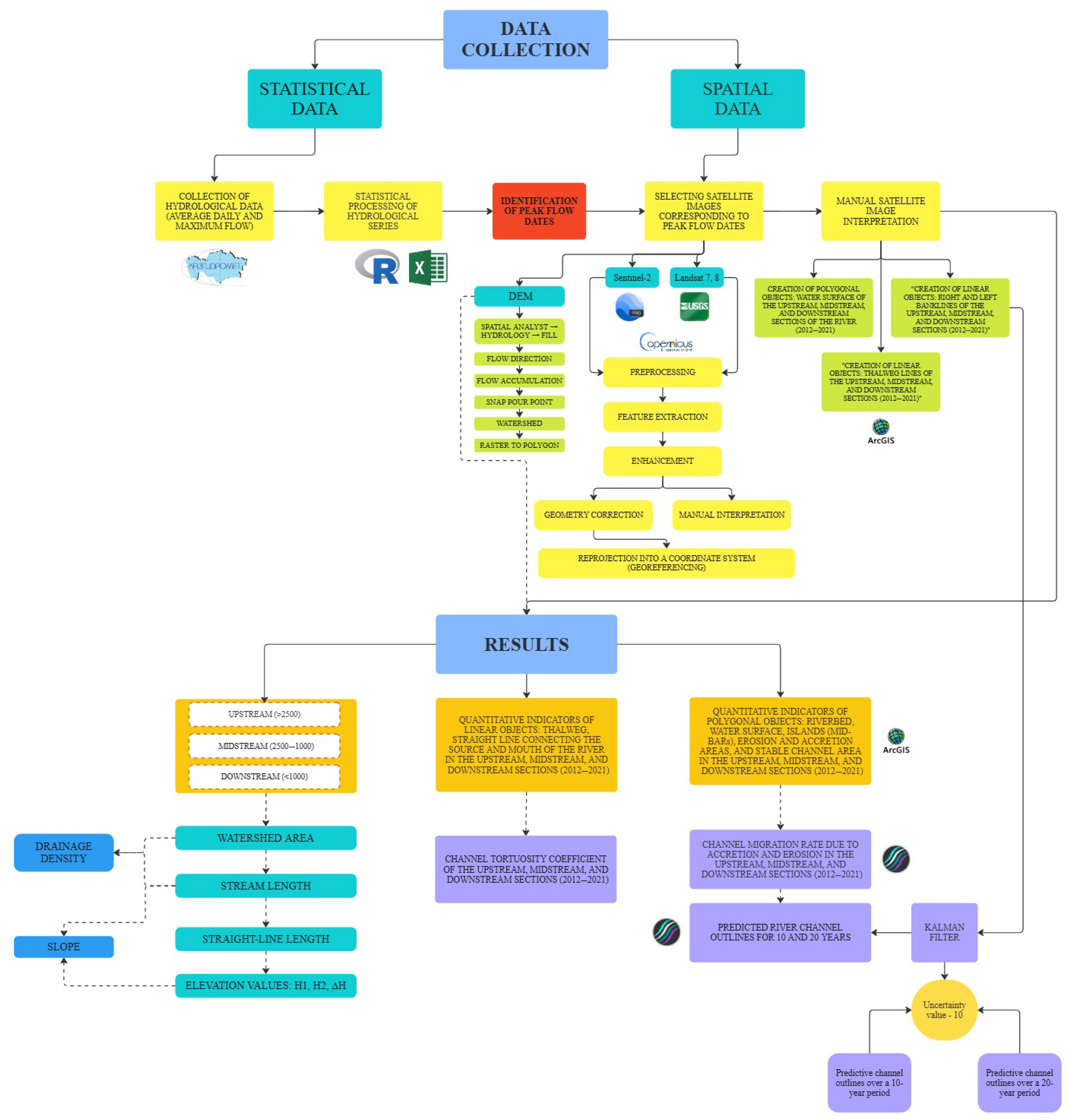
2.3. Methods
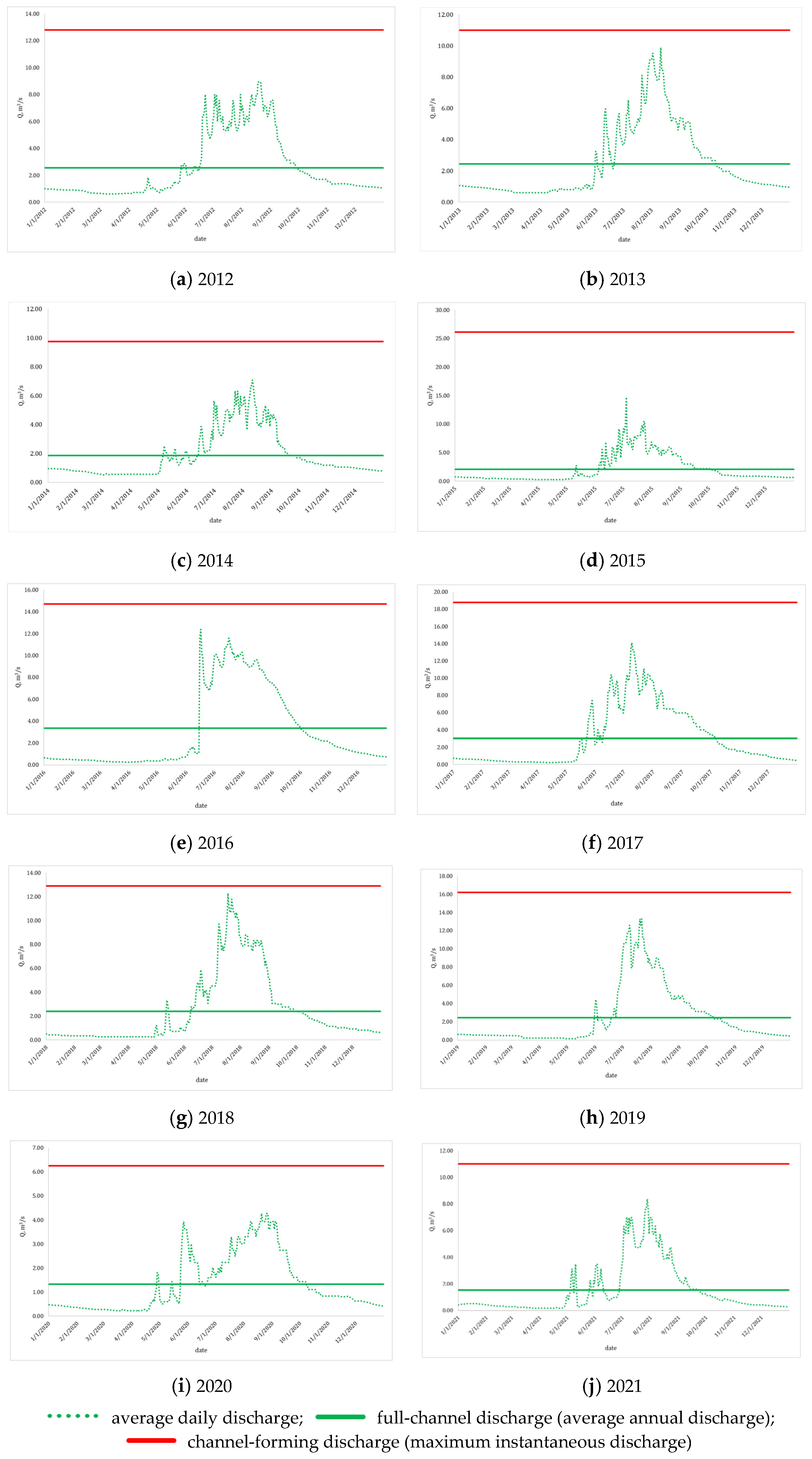
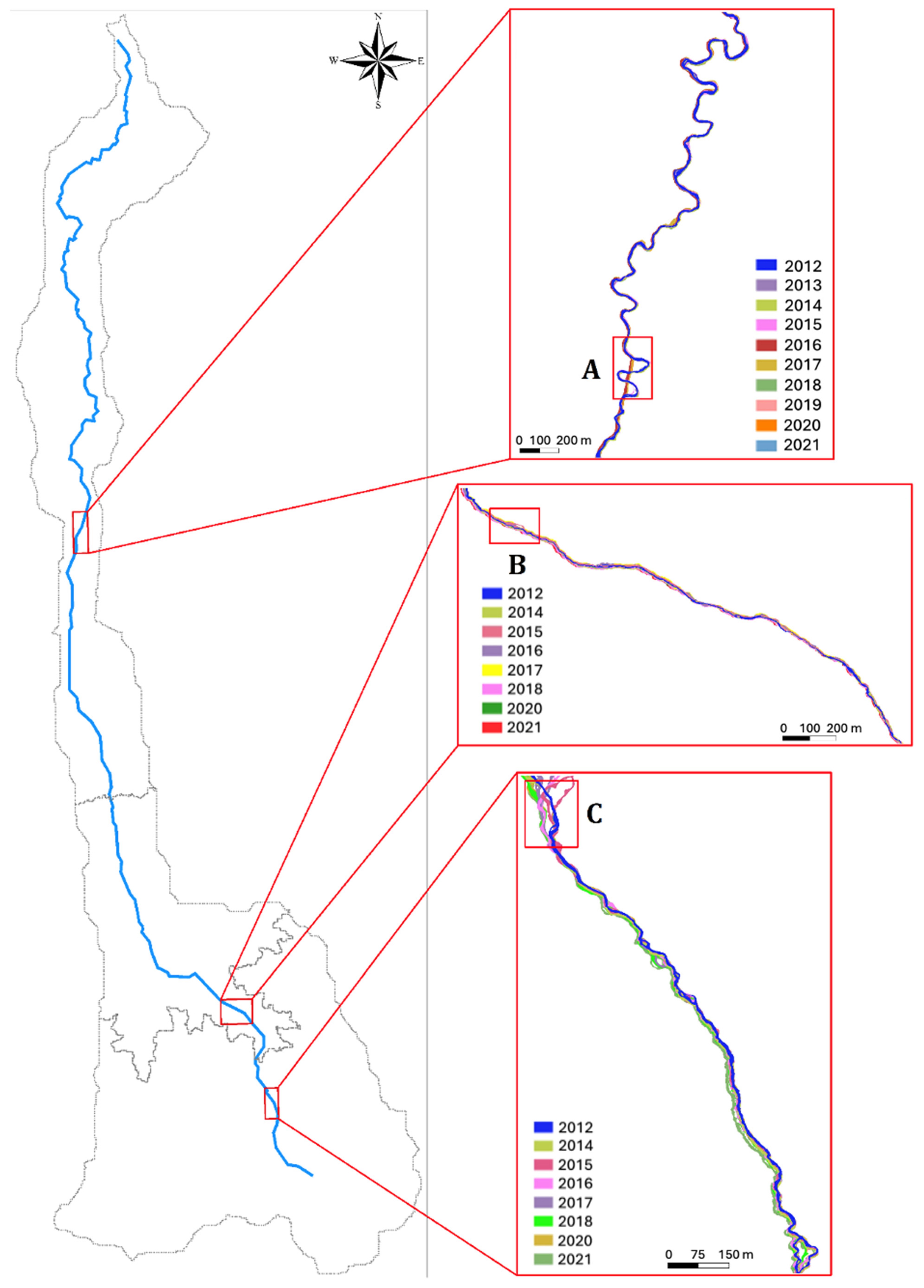
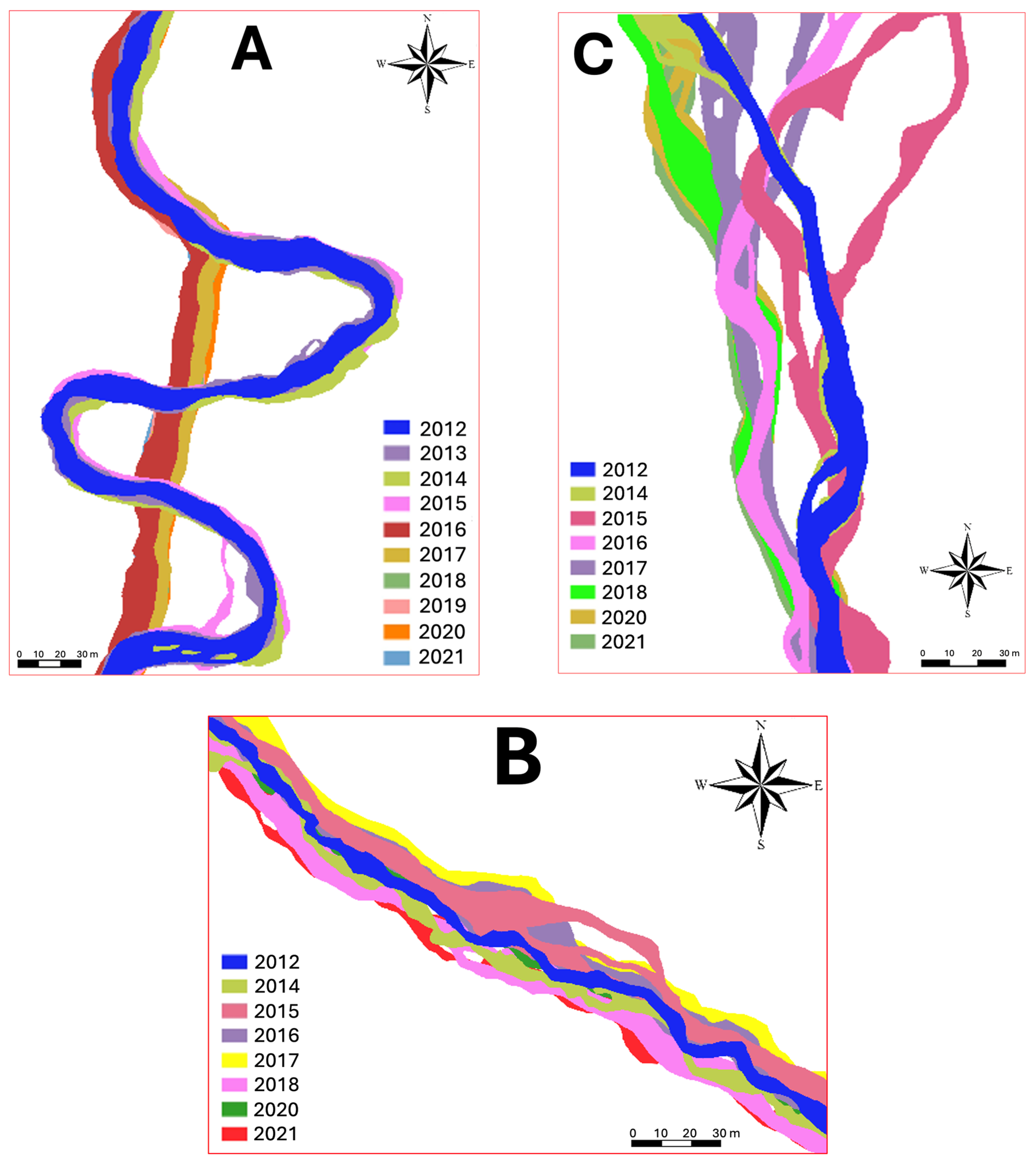
3. Results and Discussion
4. Conclusions
Author Contributions
Funding
Data Availability Statement
Acknowledgments
Conflicts of Interest
References
- Antropovskij, V.I.; Denisova, I.V.; Izotov, A.V. Hydrological and Morphological Approach to the Study of Channel Processes. Proc. Russ. State Pedagog. Univ. Named After A. I. Herzen 2005, 13, 233–241. (In Russian) [Google Scholar]
- Baryshnikov, N.B.; Isaev, D.I. Channel Processes: Textbook; Saint Petersburg State University of HydroMeteorology (RSHU): Moscow, Russia, 2014; p. 504. (In Russian) [Google Scholar]
- Dumnov, A.D.; Kirsanov, A.A.; Kiseleva, E.A.; Lipiyainen, K.L.; Rybalskiy, N.G.; Snakin, V.V.; Afanasyev, A.N.; Borisova, O.K.; Velichko, A.A.; Grebennikova, T.A. National Atlas of Russia, Volume 2: Nature. Ecology; CPA “Cartographia”: Moscow, Russia, 2007; ISBN 5-85120-250-5. (In Russian) [Google Scholar]
- Zhandaev, M.Z. Regressive Erosion and Interception of River Headwaters (on the Example of the Rivers of the Zailiysky Alatau). Geomorfologiya 1975, 1, 73–78. (In Russian) [Google Scholar] [CrossRef]
- Zhandaev, M.Z. On the Issue of Gully Erosion in Northern Kazakhstan. Sci. Notes Kazakh State Univ. 1954, 18, 73–75. (In Russian) [Google Scholar]
- Zhandaev, M.Z. Features of the Development of the Hydrographic Network in the Eastern Part of the Zailiysky Alatau. Proc. Acad. Sci. Kazakh SSR. Geol. Ser. 1954, 18, 128–132. (In Russian) [Google Scholar]
- Zhandaev, M.Z. Morphostructures of the Zailiysky Alatau and Its Foothills. In Proceedings of the Republican Scientific and Methodological Conference on Geography, Almaty, Kazakhstan, 15–17 April 1970; pp. 105–106. (In Russian). [Google Scholar]
- Zhandaev, M.Z. Erosion and Spatial Development of River Valleys. In Contemporary Relief-Forming Processes in the Territory of Kazakhstan: Collected Articles; Kazakh State University: Almaty, Kazakhstan, 1988; pp. 3–16. (In Russian) [Google Scholar]
- Zhandaev, M.Z. Channel Processes and the Problem of the Origin of Rivers and River Valleys. Proc. All-Union Geogr. Soc. 1991, 123, 425–429. (In Russian) [Google Scholar]
- Abdrasilov, S.A. Channel Processes and the Formation of Intracontinental Deltas: A Case Study of the Ili River Delta; Rauan: Almaty, Kazakhstan, 1994; 191p. (In Russian) [Google Scholar]
- Abdrasilov, S.A.; Dyusenova, R.K.; Pulatova, E.A. Assessment of the Channel Stability of the Irtysh River Using A.V. Karaushev’s Method. In Natural and Social Problems of the Geography of Arid Territories; Kazakh University: Almaty, Kazakhstan, 2001; pp. 34–46. (In Russian) [Google Scholar]
- Burlybaev, M.Z.; Abdrasilov, S.A.; Tairov, T.Z. Assessment of the Channel Stability of the Irtysh River Using K.V. Grishanin’s Method. Hydrometeorol. Ecol. 2002, 3, 54–61. (In Russian) [Google Scholar]
- Chigrinets, L.Y.; Duskayev, K.K. Sediment Runoff Study of Mountain Rivers of the Zailiysky and Dzhungarian Alatau. Bull. Kazakh State Univ. Ser. Ecol. 1997, 2, 71–77. (In Russian) [Google Scholar]
- Duskayev, K.K.; Chigrinets, L.Y. Study of Water Erosion Characteristics for Assessing the Ecological Condition of Mountain Rivers in Southeastern Kazakhstan. In Stability, Anthropogenic Transformation and Optimization of the Natural Environment of Kazakhstan: Proceedings of the Republican Scientific Conference; Almaty, Kazakhstan, 1998; pp. 44–46. (In Russian) [Google Scholar]
- Duskayev, K.K.; Chigrinets, L.Y. Assessment of the Intensity of Erosion Processes in the River Basins of the Zailiysky and Dzhungarian Alatau Using Sediment Discharge Data. In Problems of Hydrometeorology and Ecology: Proceedings of the International Conference Dedicated to the 50th Anniversary of the KazSRI ECM; Almaty, Kazakhstan, 2001; pp. 168–170. (In Russian) [Google Scholar]
- Duskayev, K.K.; Chigrinets, L.Y. Sediment Runoff and Assessment of the Erosional Activity of Mountain Rivers in Kazakhstan. In Proceedings of the 27th Plenary Interuniversity Coordination Meeting on the Problem of Erosional, Channel, and Estuarine Processes, Izhevsk, Russia, 8–12 October 2012; Reports and Brief Communications. pp. 106–107. (In Russian). [Google Scholar]
- Dostay, Z.D.; Musabayeva, M.N. Channel Processes as a Factor of Intrasystem Organization of Geosystem Development. Hydrometeorol. Ecol. 2007, 3, 100–105. (In Russian) [Google Scholar]
- Golubtsov, V.V. Classification of Channels of Semi-Mountainous and Mountain Streams Based on the Roughness Coefficient. Hydrometeorol. Ecol. 2001, 1–2, 87–101. (In Russian) [Google Scholar]
- Golubtsov, V.V. Modeling of Mountain River Runoff Under Conditions of Limited Information; Kazhydromet: Almaty, Kazakhstan, 2010; 232p, ISBN 978-601-278-368-1. (In Russian) [Google Scholar]
- Khalykov, Y.Y.; Lyy, Y.F.; Kakimzhanov, Y.K.; Makimbayeva, M.M.; Sharapkanova, Z.M. Study of Gully Erosion Using Method of Terrestrial Laser Scanning. Hydrometeorol. Ecol. 2020, 2, 146–164. (In Kazakh) [Google Scholar]
- Khalykov, Y.; Lyy, Y.; Abitbayeva, A.; Togys, M.; Valeyev, A. Terrestrial laser scanning methods formonitoring erosion of the southwestern shore of Alakol lake. In Proceedings of the 20th International Multidisciplinary Scientific GeoConference SGEM 2020, Albena, Bulgaria, 16–25 August 2020; STEF92 Technology: Sofia, Bulgaria, 2020; pp. 117–130. [Google Scholar] [CrossRef]
- Khalykov, Y.; Lyy, Y.; Sarybaev, E.; Togys, M.; Uksukbayeva, S.; Sharapkhanova, Z. Study of Conditions of Gully Formation in Mountain Regions of South-East Kazakhstan with Use of GIS-Technologies. Geod. Cartogr. 2021, 47, 54–65. [Google Scholar] [CrossRef]
- Taukenov, T.R.; Yerzhanova, Z.S. Formation of Log Jams on the Rivers of the Buktyrma Basin and Their Geomorphodynamic Functions. Hydrometeorol. Ecol. 2018, 2, 118–129. (In Russian) [Google Scholar]
- Velikanov, M.A. On the Formulation of the Problem of Channel Processes. Meteorol. Hydrol. 1946, 3, 36–46. (In Russian) [Google Scholar]
- Velikanov, M.A. Dynamics of Channelized Flows. Vol. I: Flow Structure; Gostekhizdat: Moscow, Russia, 1954; 324p. (In Russian) [Google Scholar]
- Velikanov, M.A. Dynamics of Channelized Flows. Vol. II: Sediments and the Channel; Gostekhizdat: Moscow, Russia, 1955; 323p. (In Russian) [Google Scholar]
- Velikanov, M.A. Channel Process; Gospfizmatizdat: Moscow, Russia, 1958; 395p. (In Russian) [Google Scholar]
- Makkaveev, N.I. The River Channel and Erosion in Its Basin; Faculty of Geography, Moscow State University: Moscow, Russia, 2003; 353p, (Reprint of 1955 ed.). (In Russian) [Google Scholar]
- Makkaveev, N.I.; Chalov, R.S. On the Morphological Features of Modern Accumulation in a River Valley. Izv. Ross. Akad. Nauk. Seriya Geogr. 1963, 3, 84–89. (In Russian) [Google Scholar]
- Makkaveev, N.I.; Shataeva, S.G.; Mityakova, M.P. Channel Stability Index. Meteorol. Hydrol. 1967, 5, 72–83. (In Russian) [Google Scholar]
- Makkaveev, N.I. Runoff and Channel Processes; Moscow State University Publishing House: Moscow, Russia, 1971; 115p. (In Russian) [Google Scholar]
- Makkaveev, N.I. Erosional and Accumulative Processes and the Relief of a River Channel. Selected Works; Moscow State University Publishing House: Moscow, Russia, 1998; 285p, ISBN 5-211-03899-1. (In Russian) [Google Scholar]
- Mirtskhulava, T.E. Channel Scour and Methods for Assessing Their Stability; Kolos: Moscow, Russia, 1967; 179p. (In Russian) [Google Scholar]
- Mirtskhulava, T.E. Fundamentals of the Physics and Mechanics of Channel Erosion; Gidrometeoizdat: Leningrad, Russia, 1988; 303p, ISBN 5-286-00041-X. (In Russian) [Google Scholar]
- Chalov, R.S.; Khmeleva, N.V. Development of the Theory of Erosional and Accumulative Processes in the Works of Professor N.I. Makkaveev. In Soil Erosion and Channel Processes, Issue 7; Moscow University Press: Moscow, Russia, 1979; pp. 5–20. (In Russian) [Google Scholar]
- Chalov, R.S. Geographical Studies of Channel Processes; Moscow University Press: Moscow, Russia, 1979; 232p. (In Russian) [Google Scholar]
- Chalov, S.R.; Ermakova, A.S.; Yesin, E.V. Logjams on Rivers, Their Channel-Forming and Environmental Role. Vestn. Mosk. Univ. Seriya 5 Geogr. 2010, 6, 25–31. (In Russian) [Google Scholar]
- Chalov, R.S.; Kamyshev, A.A. Concepts of Hydromorphology and River Morphodynamics in Channel Processes Science. Izv. Ross. Akad. Nauk. Seriya Geogr. 2020, 84, 844–854. (In Russian) [Google Scholar] [CrossRef]
- Kuznetsov, K.L. Channel Processes of Mountain Rivers of the Zailiyskiy Alatau and the BAM Zone: Abstract of the Dissertation for the Degree of Candidate of Geographical Sciences; Kuznetsov, K.L., Ed.; Moscow State University Named after M.V. Lomonosov, Order of Lenin, Order of the Red Banner of Labour, and Order of the October Revolution: Moscow, Russia, 1987; 24p. (In Russian) [Google Scholar]
- Kuznetsov, K.L.; Chalov, R.S. Mountain rivers channel processes and morphology under conditions of frequent mudflows (a case study of the Zailiysky Alatau rivers). Geomorfologiya 1988, 2, 71–78. [Google Scholar]
- Druzhinin, G.A. Study of Basic Hydromorphometric Characteristics in Mountain Channel Flows: Abstract of the Dissertation for the Degree of Candidate of Technical Sciences; Druzhinin, G.A., Ed.; Central Asian Research Institute of Irrigation (Sredneaziatskiy NII Irrigatsii), Ministry of Land Reclamation and Water Management of the USSR: Tashkent, USSR, 1977; 20p. (In Russian) [Google Scholar]
- Grishanin, K.V. Dynamics of Channelized Flows, 2nd ed.; Gidrometeoizdat: Leningrad, Russia, 1979; 312p. (In Russian) [Google Scholar]
- Grishanin, K.V. Stability of River and Canal Channels; Gidrometeoizdat: Leningrad, Russia, 1974; 144p. (In Russian) [Google Scholar]
- Baryshnikov, N.B.; Popov, I.V. Dynamics of Channelized Flows and Channel Processes; Gidrometeoizdat: Leningrad, Russia, 1988; 454p, ISBN 5-286-00012-6. (In Russian) [Google Scholar]
- Lane, E.W. The importance of fluvial morphology in hydraulic engineering. Am. Soc. Civ. Eng. Proc. 1954, 81, 745. [Google Scholar] [CrossRef]
- Leopold, L.B.; Wolman, M.G. River channel patterns: Braided, meandering, and straight. US Government Printing Office. US Geol. Survey Prof. Paper 1957, 282, 39–84. [Google Scholar]
- Montgomery, D.R.; Buffington, J.M. Channel-reach morphology in mountain drainage basins. GSA Bull. 1997, 109, 596–611. [Google Scholar] [CrossRef]
- Chin, A. The morphologic structure of step–pools in mountain streams. Geomorphology 1999, 27, 191–204. [Google Scholar] [CrossRef]
- Chrisben Sam, S.; Gurugnanam, B. Coastal transgression and regression from 1980 to 2020 and shoreline forecasting for 2030 and 2040, using DSAS along the southern coastal tip of Peninsular India. Geod. Geodyn. 2022, 13, 585–594. [Google Scholar] [CrossRef]
- Debnath, J.; Sahariah, D.; Saikia, A.; Meraj, G.; Nath, N.; Lahon, D.; Annayat, W.; Kumar, P.; Chand, K.; Singh, S.; et al. Shifting Sands: Assessing Bank line Shift Using an Automated Approach in the Jia Bharali River, India. Land 2023, 12, 703. [Google Scholar] [CrossRef]
- Hasanuzzaman, M.; Bera, B.; Islam, A.; Shit, P. Estimation and prediction of riverbank erosion and accretion rate using DSAS, BEHI, and REBVI models: Evidence from the lower Ganga River in India. Nat. Hazards 2023, 118, 1163–1190. [Google Scholar] [CrossRef]
- Felipe, A.J.B.; Alejo, L.A.; Padre, R.J.; Bareng, J.L.R. Past and future river bank trend assessment of lower Cagayan River, Philippines. Environ. Dev. Sustain. 2024, 26, 1–36. [Google Scholar] [CrossRef]
- Shuangmi, X.; Wenzhu, Z.; Bin, W.; Shengquan, L.; Guanhai, G.; Yanhua, L. Evaluating the migration of boundary river shorelines and coastal land cover changes for the Beilun River between China and Vietnam. J. Hydrol. Reg. Stud. 2025, 57, 102167. [Google Scholar] [CrossRef]
- Singh, B.; Bhattacharjee, N. Bank line Migration Analysis of Brahmaputra River in Morigaon District, Assam using Automated Method. Indian J. Sci. Technol. 2024, 17, 2508–2518. [Google Scholar] [CrossRef]
- Harikrishna, S.; Gurugnanam, B.; Bairavi, S.; Shekar, S. Geospatial technology based shoreline change analysis (1992–2022) and predictive forecast modeling for 2032 and 2042, utilizing DSAS, along the eastern coast of India. Kuwait J. Sci. 2024, 51, 100272. [Google Scholar] [CrossRef]
- Article, A.; Kılar, H.; Aydın, O.; Kelimeler, A.; Kıyı, K.; Tahmini, H.; Filtresi, K.; Dijital, Ş.; Şeridi, K.; Sistemi, A. Applying the kalman filter model to forecast shoreline positions: A case study in Şile, İstanbul. Türk Coğrafya Derg. 2024, 85, 47–53. [Google Scholar]
- Ranjan, A.; Thendiyath, R. Analysis of channel shifting and its impact on morphometric parameters of Sone river basin, Bihar, India. Acta Geophys. 2025, 73, 3531–3547. [Google Scholar] [CrossRef]
- Abd-Elhamid, H.F.; Zeleňáková, M.; Barańczuk, J.; Gergelova, M.B.; Mahdy, M. Historical Trend Analysis and Forecasting of Shoreline Change at the Nile Delta Using RS Data and GIS with the DSAS Tool. Remote Sens. 2023, 15, 1737. [Google Scholar] [CrossRef]
- Islam, M.S.; Crawford, T.W. Assessment of Spatio-Temporal Empirical Forecasting Performance of Future Shoreline Positions. Remote Sens. 2022, 14, 6364. [Google Scholar] [CrossRef]
- Chigrinets, A.G.; Duskayev, K.K.; Mazur, L.P.; Chigrinets, L.Y.; Musina, A.K.; Zhanabayeva, Z.A.; Akhmetova, S.T. Rivers of the Metropolis of Almaty: Monograph; Izaza University: Almaty, Kazakhstan, 2021; 310p, ISBN 978-601-04-5247-3. (In Russian) [Google Scholar]
- Duskayev, K.; Mussina, A.; Rodrigo-Ilarri, J.; Zhanabayeva, Z.; Tursyngali, M.; Rodrigo-Clavero, M.E. Study of temporal changes in the hydrographic network of small mountain rivers in the Ile Alatau, Kazakhstan. Hydrol. Res. 2023, 54, 1420–1431. [Google Scholar] [CrossRef]
- Dostaiuly, Z. General Hydrology; Karasai: Almaty, Kazakhstan, 2011; 280p, ISBN 978-601-7212-10-0. (In Kazakh) [Google Scholar]
- Davydov, L.K.; Dmitrieva, A.A.; Konkina, N.G. General Hydrology, 2nd ed.; revised and expanded; Gidrometeoizdat: Saint Petersburg, Russia, 1973; 462p. (In Russian) [Google Scholar]
- Resursy Poverkhnostnykh Vod SSSR. Bassein oz. Balkhash; Gidrometeoizdat: Leningrad, Russia, 1970; Volume 13, p. 643. (In Russian) [Google Scholar]
- Zhandayev, M.Z. Nature of the Zailiyskiy Alatau; Alma-Ata, Kazakhstan, 1978; 159p. (In Russian) [Google Scholar]
- Duskayev, K.K.; Chygrynets, A.G.; Mussina, A.K.; Zhanabayeva, Z.A.; Akhmetova, S.T.; Yermash, E.K. Assessment of the Maximum Water Discharge of the Rivers of Almaty. Hydrometeorol. Ecol. 2019, 2, 96–110. (In Russian) [Google Scholar]
- Medeu, A.R.; Baimoldaev, T.A.; Kirenskaya, T.L. Mudflow Phenomena of South-Eastern Kazakhstan: V.4. Part 1 Monograph; Anthology of Mudflow Phenomena and Their Research, Institute of Geography: Almaty, Kazakhstan, 2016; p. 576. (In Russian) [Google Scholar]
- Copernicus Browser. Available online: https://browser.dataspace.copernicus.eu/ (accessed on 19 November 2024).
- USGS Science for a Changing World. EarthExplorer. Available online: https://earthexplorer.usgs.gov/ (accessed on 25 November 2024).
- Mei, G.; Tipper, J.; Xu, N. 3D Geological Modeling and Visualization of Rock Masses Based on Google Earth: A Case Study. In Proceedings of the 2013 5th International Conference on Computer Science and Information Technology, Amman, Jordan, 27–28 March 2013; IEEE: Piscataway, NJ, USA, 2013. [Google Scholar] [CrossRef]
- Nwilo, P.; Okolie, C.; Onyegbula, J.; Arungwa, I.; Ayoade, O.; Daramola, O.; Orji, M.; Uyo, I. Positional Accuracy Assessment Of Historical Google Earth Imagery. Appl. Geomat. 2022, 14, 545–568. [Google Scholar] [CrossRef]
- Kochetkov, A.V. Prospects for the Use of Google Earth Information Resources for Surveying and Designing Transport Infrastructure Facilities. Electron. Sci. J. Alm. Space Time 2013, 4, 18. (In Russian) [Google Scholar]
- Himmelstoss, E.A.; Henderson, R.E.; Kratzmann, M.G.; Farris, A.S. Digital Shoreline Analysis System (DSAS) Version 5.1 User Guide (Report Nos. 2021–1091; Open-File Report, p. 104); USGS Publications Warehouse: Reston, VA, USA, 2021. [Google Scholar] [CrossRef]
- Kiselev, D.V.; Zemtsov, V.A. Determination of Characteristic Water Discharges with the Most Intensive Impact on River Channel Formation (Case Study of the Rivers of Tomsk Region). Tomsk. State Univ. J. 2011, 351, 169–174. (In Russian) [Google Scholar]
- Kamenskov, Y.U.I. On the Definition and Significance of Channel-Forming Water Discharge. Meteorol. Hydrol. 1986, 7, 119–120. (In Russian) [Google Scholar]
- Antropovsky, V.I. Hydrological and Morphological Patterns and Baseline Forecasts of River Channel Transformation; Krismas+: St. Petersburg, Russia, 2006; p. 216. (In Russian) [Google Scholar]
- Karasev, I.F. Channel-Forming Water Discharges. Meteorol. Hydrol. 1986, 8, 94–98. (In Russian) [Google Scholar]
- Chalov, R.S. Channel-Forming Water Discharges. Vestn. Mosk. Univ. Ser. 5 Geogr. 2006, 1, 11–19. (In Russian) [Google Scholar]
- Navratil, O.; Albert, M.; Herouin, E.; Gresillon, J. Determination of bankfull discharge magnitude and frequency: Comparison of methods on 16 gravel-bed river reaches. Earth Surf. Process. Landf. 2006, 31, 1345–1363. [Google Scholar] [CrossRef]
- Navratil, O.; Albert, M.-B.; Breil, P. Test of three methods to detect the overbank flow from water level time-series analysis. Hydrol. Process. 2010, 24, 2452–2464. [Google Scholar] [CrossRef]
- Chigrinets, A.G.; Duskayev, K.K.; Satmurzaev, A.A.; Insigenova, A.E.; Salavatova, Z.T. Study of the Main Characteristics and Intra-Annual Distribution of the Water Flow of the Rivers of the Territory of Almaty City. Hydrometeorol. Ecol. 2021, 3, 44–62. (In Russian) [Google Scholar] [CrossRef]
- STO GGI 52.08.48-2020; Selection of a Digital Cartographic Base for Determining Hydrographic Characteristics. FSBI SHI: Saint Petersburg, Russia, 2020. (In Russian)
- R 52.08.874-2018; Determination of Hydrographic Characteristics by Cartographic Method. FSBI SHI: Saint Petersburg, Russia, 2018. (In Russian)
- STO GGI 52.08.40-2017; Determination of Morphometric Characteristics of Terrestrial Water Bodies and Their Catchment Areas Using Geographic Information System Technology Based on Digital Maps of the Russian Federation and Satellite Images. FSBI SHI: Saint Petersburg, Russia, 2017. (In Russian)
- Shikhov, A.N.; Gerasimov, A.P.; Ponomarchuk, A.I.; Perminova, E.S. Thematic Decoding and Interpretation of Medium- and High-Resolution Satellite Images: Textbook; Perm State National Research University: Perm, Russia, 2020; p. 191. (In Russian) [Google Scholar]
- Ophra, S.J.; Begum, S.; Islam, R.; Islam, M.N. Assessment of bank erosion and channel shifting of Padma River in Bangladesh using RS and GIS techniques. Spat. Inf. Res. 2018, 26, 599–605. [Google Scholar] [CrossRef]
- Farris, A.S.; Long, J.W.; Himmelstoss, E.A. Accuracy of shoreline forecasting using sparse data. Ocean. Coast. Manag. 2023, 239, 106621. [Google Scholar] [CrossRef]
- Leontyev, O.K.; Rychagov, G.I. General Geomorphology; Vysshaya Shkola: Moscow, Russia, 1979; p. 287. (In Russian) [Google Scholar]
- Chalov, R.S. Channel Studies: Theory, Geography, Practice. Vol. 1. Channel Processes: Factors, Mechanisms, Forms of Manifestation and Conditions for the Formation of River Channels; LKI Publishing House: Moscow, Russia, 2008; p. 608. (In Russian) [Google Scholar]
- Chalov, R.S. Types of Channel Processes and Principles of Morphodynamic Classification of River Channels. Geomorphology 1996, 1, 25–36. (In Russian) [Google Scholar]
- Baryshnikov, N.B. Anthropogenic Impact on Self-Regulating Systems: River Basin–Streamflow–Channel; Russian State Hydrometeorological University: Saint Petersburg, Russia, 1999; p. 218. (In Russian) [Google Scholar]
- Baryshnikov, N.B.; Pagin, A.O. Hydraulic Resistance of River Channels. Bull. Admiral S.O. Makarov State Univ. Marit. Inland Shipp. 2010, 6, 90–93. (In Russian) [Google Scholar] [CrossRef]
- Khan, Z.U.; Khan, D.; Murtaza, N.; Pasha, G.A.; Alotaibi, S.; Rezzoug, A.; Benzougagh, B.; Khedher, K.M. Advanced Prediction Models for Scouring Around Bridge Abutments: A Comparative Study of Empirical and AI Techniques. Water 2024, 16, 3082. [Google Scholar] [CrossRef]
- Zeeshan, A.; Nadir, M.; Ghufran, A.P.; Sohail, I.; Abdul, R.G.; Fakhar, M.A. Predicting scour depth in a meandering channel with spur dike: A comparative analysis of machine learning techniques. Phys. Fluids 2025, 37, 045158. [Google Scholar] [CrossRef]

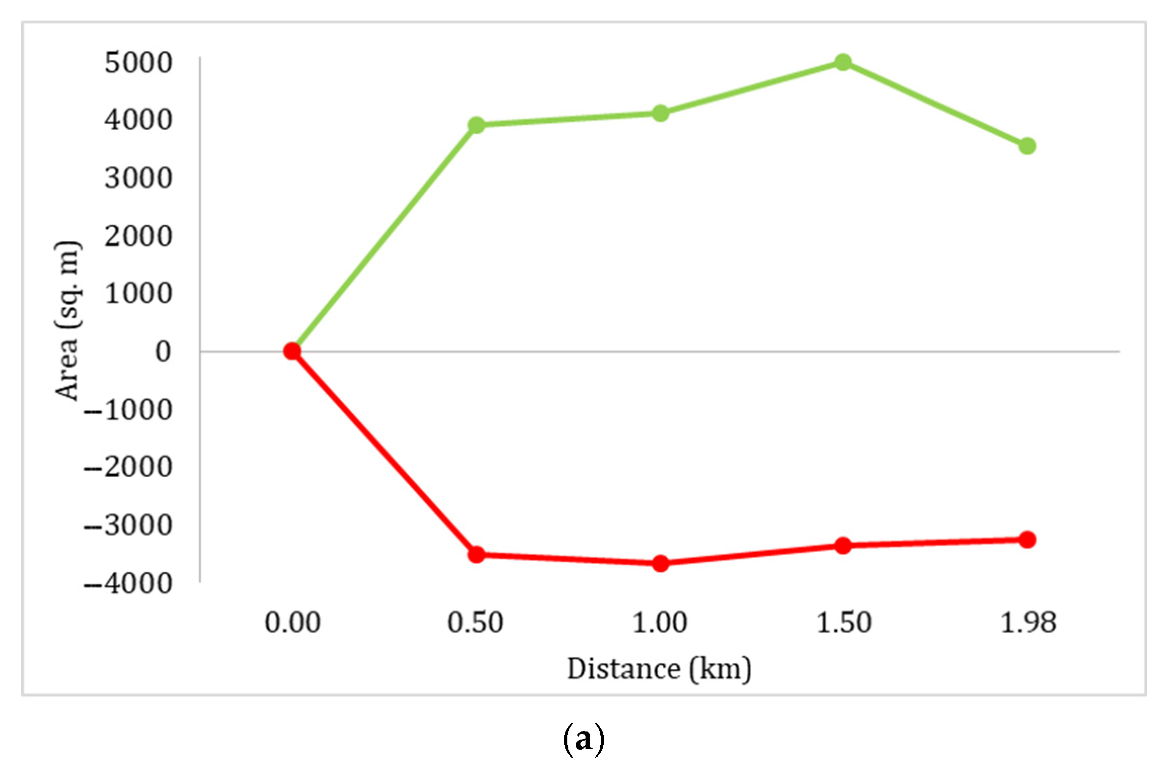
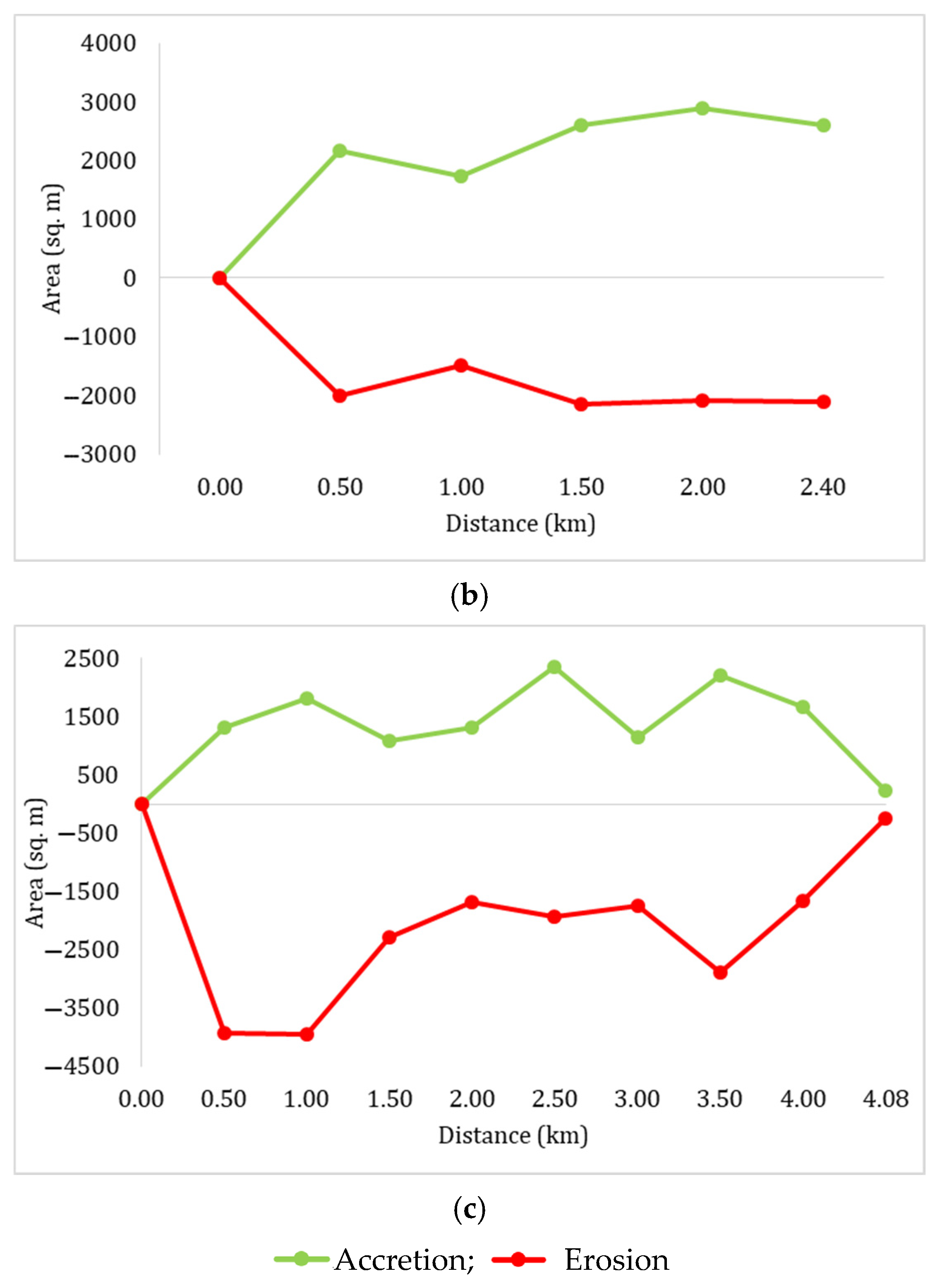
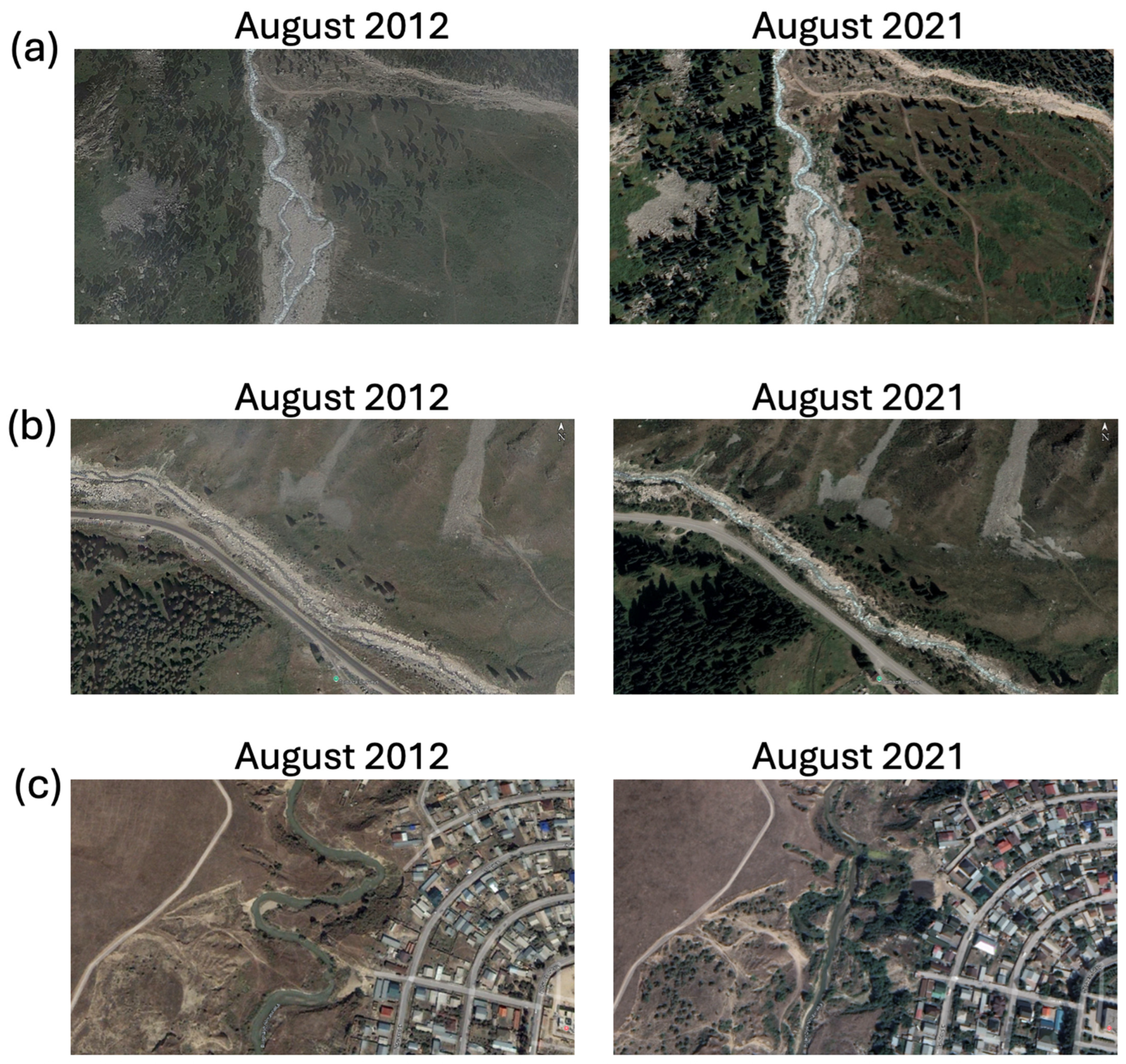
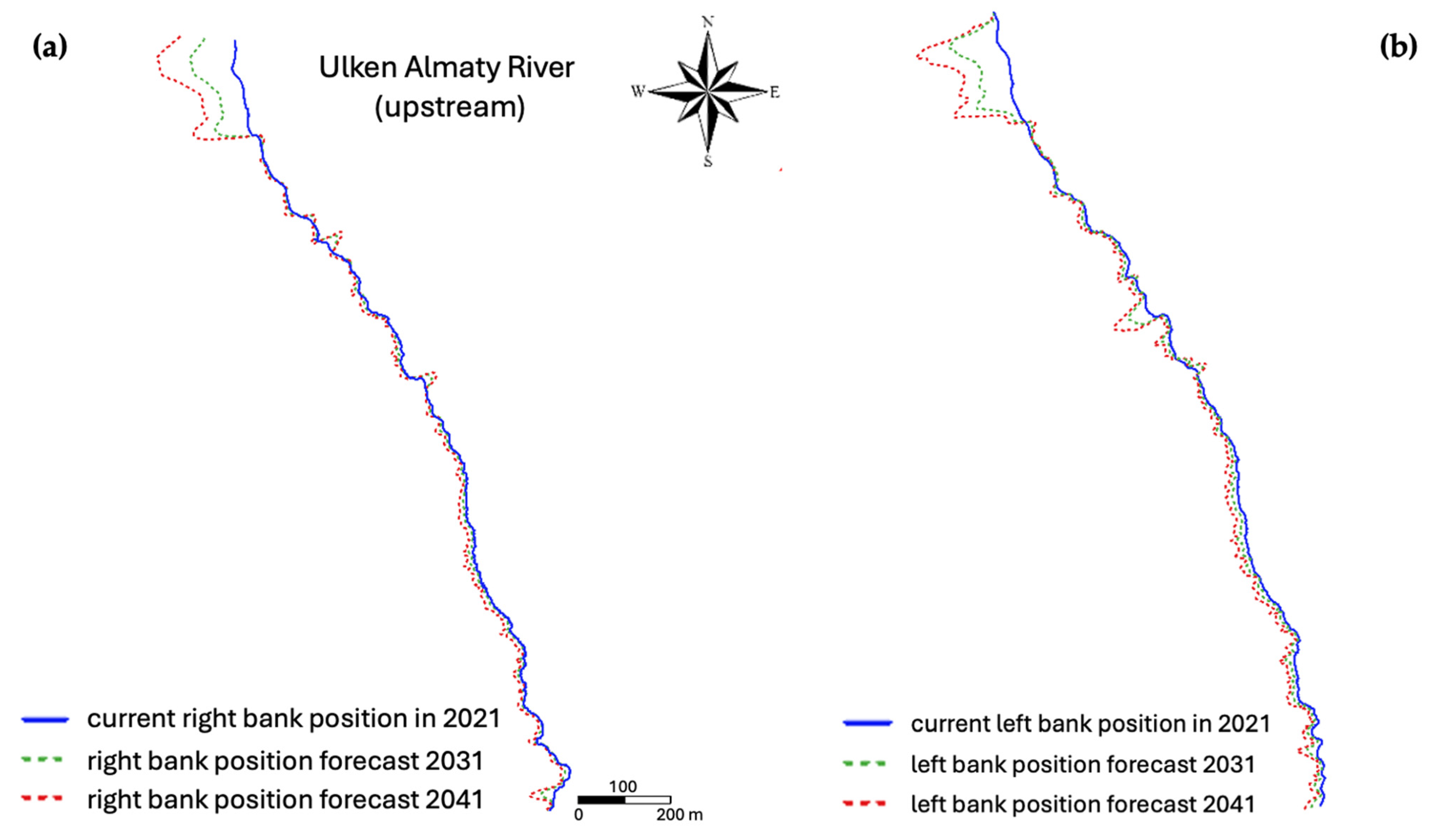
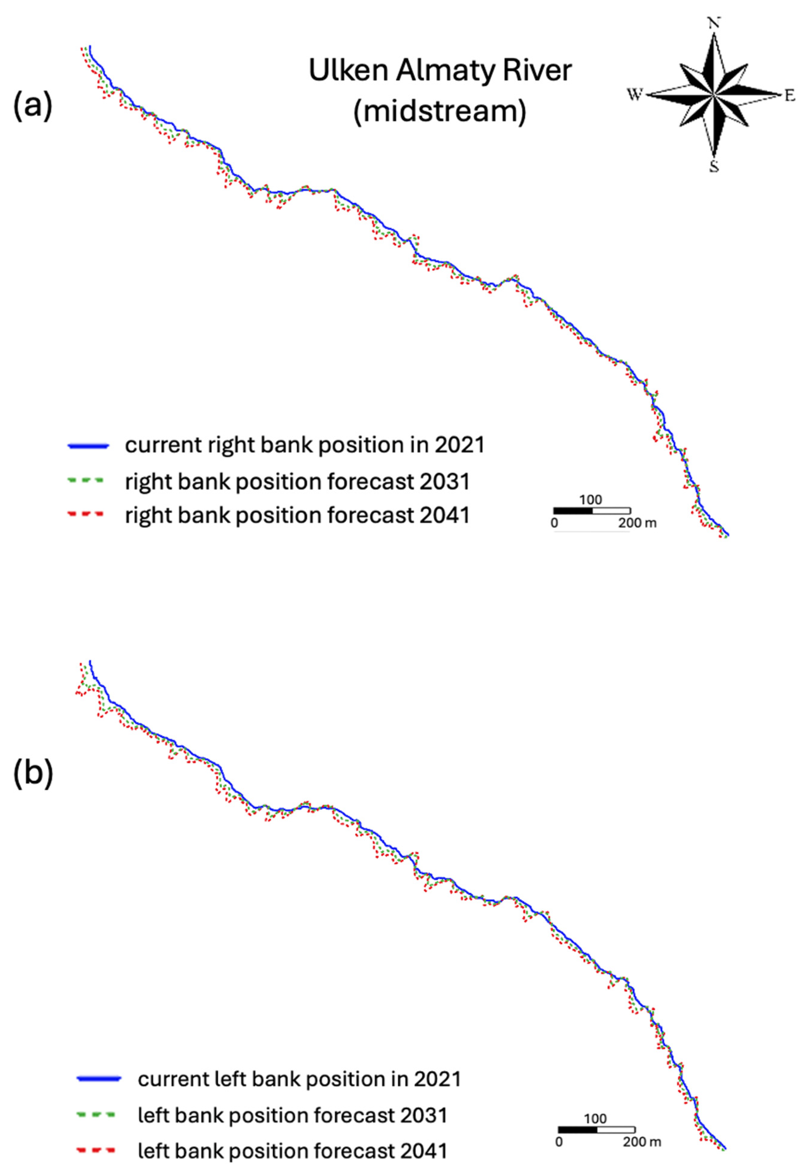
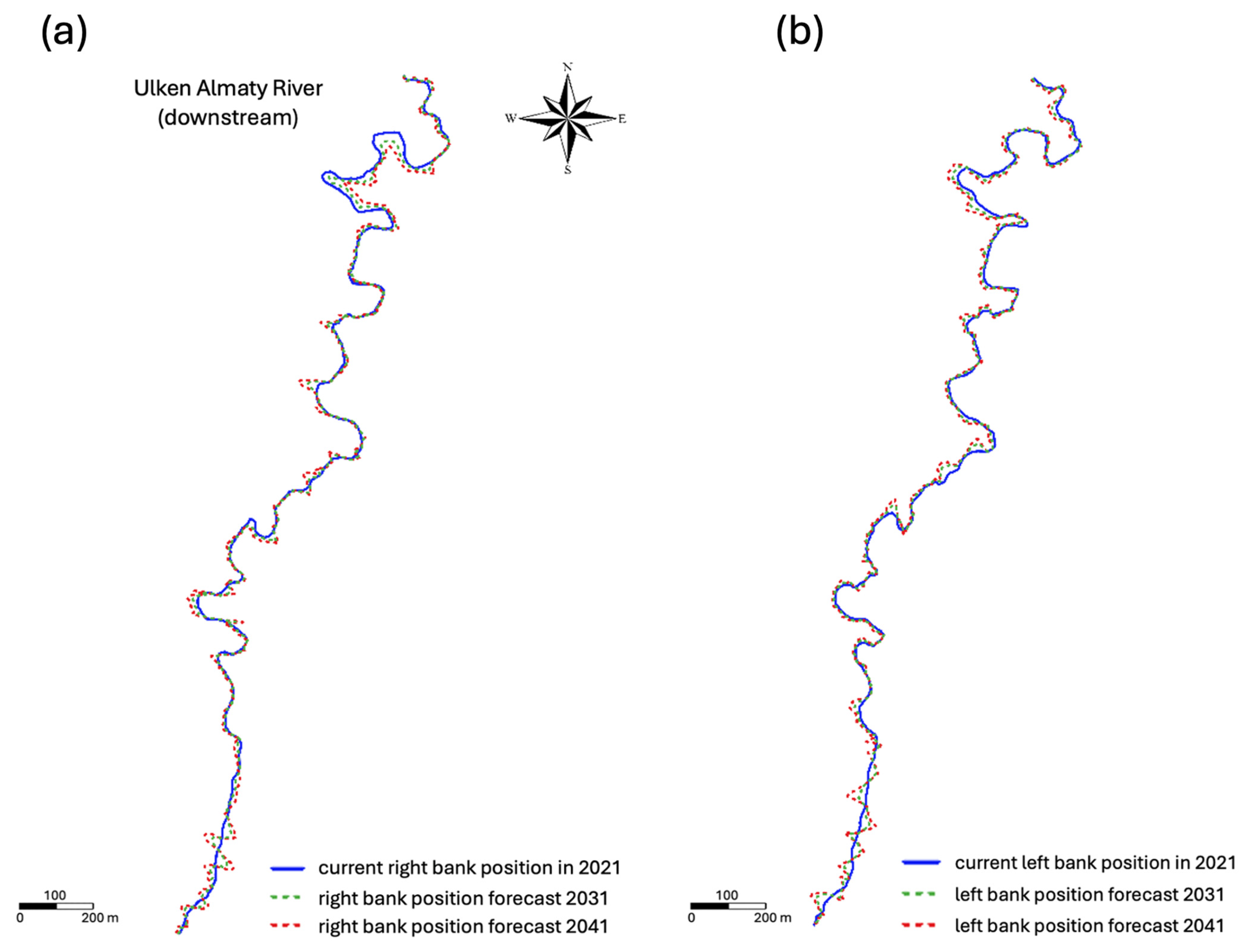
| Sections | Upstream Section | Midstream Section | Downstream Section |
|---|---|---|---|
| Image date | 12 August 2012 | 12 August 2012 | 19 August 2012 |
| - | - | 15 August 2013 | |
| 14 May 2014 | 14 May 2014 | 14 May 2014 | |
| 15 August 2015 | 15 August 2015 | 15 August 2015 | |
| 9 July 2016 | 9 July 2016 | 12 August 2016 | |
| 17 June 2017 | 17 June 2017 | 17 June 2017 | |
| 20 July 2018 | 20 July 2018 | 20 July 2018 | |
| - | - | 18 June 2019 | |
| 13 July 2020 | 21 June 2020 | 28 May 2020 | |
| 22 August 2021 | 22 August 2021 | 22 August 2021 |
| No. | Section | Watershed Area | Stream Length | Straight-Line Length | Channel Width | Drainage Density | River Source Elevation | River Mouth Elevation | Elevation Differences | River Slope | Tortuosity Coefficient | |
|---|---|---|---|---|---|---|---|---|---|---|---|---|
| F, km2 | L, km | L’, km | B, km | Dd, km/km2 | H1, km | H2, km | ΔH, km | I, ‰ | I, 0 | K | ||
| 1 | Upstream (>2500 m) | 213 | 7.99 | 7.10 | 11.7 | 0.04 | 3.10 | 2.51 | 0.60 | 74.8 | 4.29 | 1.12 |
| 2 | Midstream (2500–1000 m) | 93.3 | 18.7 | 16.2 | 7.70 | 0.20 | 2.51 | 1.00 | 1.51 | 80.5 | 4.61 | 1.15 |
| 3 | Downstream (<1000 m) | 165 | 50.1 | 41.5 | 13.0 | 0.30 | 1.00 | 0.56 | 0.44 | 8.72 | 0.50 | 1.21 |
| Years | Section | Riverbed Area | Islet Area | Water Surface Area | Channel Centreline Length | Straight-Line Length | Channel Width | Tortuosity Coefficient | ||
|---|---|---|---|---|---|---|---|---|---|---|
| m2 | m2 | m2 | m | m | Bave, m | Bmax, m | Bmin, m | |||
| 2012 | Upstream | 18,729 | 3101 | 15,628 | 1964 | 1797 | 9.88 | 51.6 | 3.93 | 1.09 |
| 2013 | - | - | - | - | - | - | - | - | - | |
| 2014 | 16,630 | 2817 | 13,812 | 1985 | 1801 | 8.64 | 51.8 | 2.98 | 1.10 | |
| 2015 | 25,787 | 5509 | 20,278 | 1973 | 1765 | 14.1 | 62.3 | 1.81 | 1.12 | |
| 2016 | 23,146 | 2859 | 20,287 | 1955 | 1775 | 12.5 | 54.8 | 4.36 | 1.10 | |
| 2017 | 24,833 | 4338 | 20,495 | 1946 | 1785 | 12.9 | 53.5 | 4.46 | 1.09 | |
| 2018 | 25,676 | 2883 | 22,793 | 1944 | 1803 | 14.2 | 60.0 | 5.69 | 1.08 | |
| 2019 | - | - | - | - | - | - | - | - | - | |
| 2020 | 19,522 | 2768 | 16,753 | 1951 | 1799 | 10.2 | 49.0 | 2.78 | 1.08 | |
| 2021 | 21,578 | 3560 | 18,017 | 1984 | 1797 | 10.8 | 51.7 | 4.06 | 1.10 | |
| 2012 | Midstream | 13,206 | 373 | 12,833 | 2376 | 2153 | 6.2 | 15.8 | 1.0 | 1.10 |
| 2013 | - | - | - | - | - | - | - | - | - | |
| 2014 | 10,338 | 257 | 10,081 | 2415 | 2151 | 4.9 | 34.0 | 1.2 | 1.12 | |
| 2015 | 17,310 | 576 | 16,734 | 2380 | 2156 | 8.0 | 20.9 | 1.3 | 1.10 | |
| 2016 | 21,358 | 163 | 21,195 | 2402 | 2162 | 9.9 | 21.2 | 3.7 | 1.11 | |
| 2017 | 22,453 | 339 | 22,114 | 2383 | 2164 | 10.5 | 21.2 | 2.9 | 1.10 | |
| 2018 | 18,061 | 536 | 17,525 | 2370 | 2149 | 8.6 | 18.1 | 2.4 | 1.10 | |
| 2019 | - | - | - | - | - | - | - | - | - | |
| 2020 | 13,143 | 160 | 12,983 | 2375 | 2155 | 6.4 | 18.6 | 1.7 | 1.10 | |
| 2021 | 15,373 | 373 | 14,999 | 2395 | 2151 | 7.0 | 19.2 | 1.7 | 1.11 | |
| 2012 | Downstream | 46,169 | 642 | 45,527 | 4111 | 2355 | 12.3 | 33.5 | 2.87 | 1.75 |
| 2013 | 49,402 | 598 | 48,804 | 4095 | 2354 | 13.0 | 52.1 | 4.47 | 1.74 | |
| 2014 | 41,109 | 1316 | 39,792 | 4182 | 2354 | 10.6 | 32.1 | 4.14 | 1.78 | |
| 2015 | 52,449 | 620 | 51,829 | 4082 | 2354 | 13.7 | 44.5 | 4.86 | 1.73 | |
| 2016 | 50,601 | 412 | 50,188 | 3816 | 2356 | 14.2 | 39.7 | 5.83 | 1.62 | |
| 2017 | 50,683 | 379 | 50,304 | 3805 | 2357 | 13.8 | 31.3 | 5.05 | 1.61 | |
| 2018 | 49,868 | 465 | 49,403 | 3839 | 2354 | 13.7 | 40.8 | 4.21 | 1.63 | |
| 2019 | 48,575 | 418 | 48,157 | 3855 | 2355 | 13.3 | 29.7 | 5.34 | 1.64 | |
| 2020 | 53,189 | 387 | 52,802 | 3853 | 2355 | 14.6 | 35.5 | 5.99 | 1.64 | |
| 2021 | 38,966 | 1208 | 37,758 | 3894 | 2355 | 10.4 | 25.4 | 1.71 | 1.65 | |
| Years | Erosion Area, m2 | Accretion Area, m2 | Unchanged Area, m2 | ||||||
|---|---|---|---|---|---|---|---|---|---|
| Upstream | Midstream | Downstream | Upstream | Midstream | Downstream | Upstream | Midstream | Downstream | |
| 2012–2013 | - | - | 3330 | - | - | 6563 | - | - | 42,839 |
| 2013–2014 | - | - | 18,465 | - | - | 10,172 | - | - | 30,937 |
| 2014–2015 | 12,791 | 7293 | 7155 | 21,949 | 14,265 | 18,495 | 3838 | 3045 | 33,954 |
| 2015–2016 | 9703 | 5085 | 23,652 | 7061 | 9133 | 21,804 | 16,084 | 12,225 | 28,797 |
| 2016–2017 | 5086 | 6793 | 19,356 | 6773 | 7887 | 19,439 | 18,060 | 14,565 | 31,245 |
| 2017–2018 | 8125 | 19,073 | 14,360 | 8968 | 14,682 | 13,545 | 16,707 | 3380 | 36,323 |
| 2018–2019 | - | - | 7979 | - | - | 6686 | - | - | 41,889 |
| 2019–2020 | - | - | 8562 | - | - | 13,175 | - | - | 40,013 |
| 2020–2021 | 5964 | 10,155 | 23,227 | 8020 | 12385 | 9004 | 13,558 | 2988 | 29,962 |
| Riverbank Change Analysis | Right Bank | Left Bank | |||
|---|---|---|---|---|---|
| LRR (m/year) | EPR (m/year) | LRR (m/year) | EPR (m/year) | ||
| Upstream | Average erosion rate | −0.49 | −0.33 | −1 | −1 |
| Average accretion rate | 1.15 | 1.58 | 0.25 | 0.19 | |
| Maximum erosion rate | −11.5 | −9 | −5.78 | −4.54 | |
| Maximum accretion rate | 26.3 | 35.6 | 1.05 | 0.65 | |
| Midstream | Average erosion rate | −0.62 | −0.70 | −0.75 | 0 |
| Average accretion rate | 0.28 | 0.32 | 0.32 | 0.34 | |
| Maximum erosion rate | −2.11 | −2 | −3 | −10.5 | |
| Maximum accretion rate | 1.86 | 1.87 | 3.28 | 3 | |
| Downstream | Average erosion rate | −1 | 0 | −0.56 | 0 |
| Average accretion rate | 1.23 | 1.15 | 1.59 | 1 | |
| Maximum erosion rate | −13.4 | −12.5 | −8.81 | −8.79 | |
| Maximum accretion rate | 12 | 11.0 | 14.8 | 18.1 | |
Disclaimer/Publisher’s Note: The statements, opinions and data contained in all publications are solely those of the individual author(s) and contributor(s) and not of MDPI and/or the editor(s). MDPI and/or the editor(s) disclaim responsibility for any injury to people or property resulting from any ideas, methods, instructions or products referred to in the content. |
© 2025 by the authors. Licensee MDPI, Basel, Switzerland. This article is an open access article distributed under the terms and conditions of the Creative Commons Attribution (CC BY) license (https://creativecommons.org/licenses/by/4.0/).
Share and Cite
Mussina, A.; Tursyngali, M.; Duskayev, K.; Rodrigo-Ilarri, J.; Rodrigo-Clavero, M.-E.; Abdullayeva, A. Forecasting Channel Morphodynamics in the Ulken Almaty River (Ile Alatau, Kazakhstan). Water 2025, 17, 2029. https://doi.org/10.3390/w17132029
Mussina A, Tursyngali M, Duskayev K, Rodrigo-Ilarri J, Rodrigo-Clavero M-E, Abdullayeva A. Forecasting Channel Morphodynamics in the Ulken Almaty River (Ile Alatau, Kazakhstan). Water. 2025; 17(13):2029. https://doi.org/10.3390/w17132029
Chicago/Turabian StyleMussina, Ainur, Marzhan Tursyngali, Kassym Duskayev, Javier Rodrigo-Ilarri, María-Elena Rodrigo-Clavero, and Assel Abdullayeva. 2025. "Forecasting Channel Morphodynamics in the Ulken Almaty River (Ile Alatau, Kazakhstan)" Water 17, no. 13: 2029. https://doi.org/10.3390/w17132029
APA StyleMussina, A., Tursyngali, M., Duskayev, K., Rodrigo-Ilarri, J., Rodrigo-Clavero, M.-E., & Abdullayeva, A. (2025). Forecasting Channel Morphodynamics in the Ulken Almaty River (Ile Alatau, Kazakhstan). Water, 17(13), 2029. https://doi.org/10.3390/w17132029


