
Remote-Sensing Indicators and Methods for Coastal-Ecosystem Health Assessment: A Review of Progress, Challenges, and Future Directions


Abstract
1. Introduction
1.1. Importance and Challenges of Coastal-Ecosystem Health Assessment
1.2. Remote-Sensing Technology Advantages and Scope of This Review
1.2.1. Core Advantages of Remote-Sensing Technology
1.2.2. Objectives and Scope of This Review
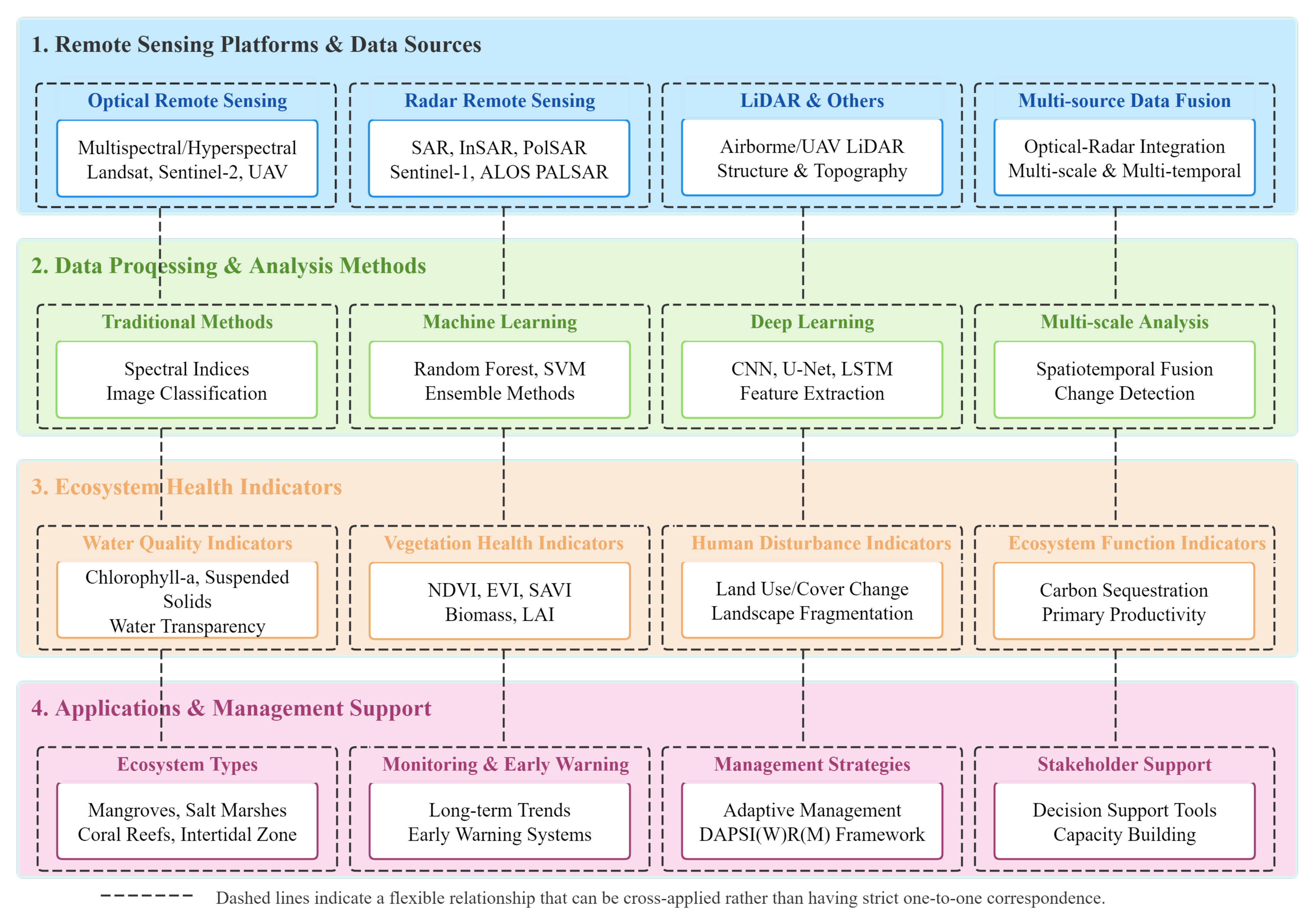
2. Remote-Sensing Platforms and Technologies
2.1. Optical Remote-Sensing Technology and Applications
2.2. Radar Remote-Sensing Technology and Applications
2.3. Multi-Source Data-Fusion Technologies
3. Data-Processing and Analysis Methods
3.1. Traditional Methods and Indices
3.2. Machine-Learning and Deep-Learning Applications
3.3. Scale Effects and Data Fusion
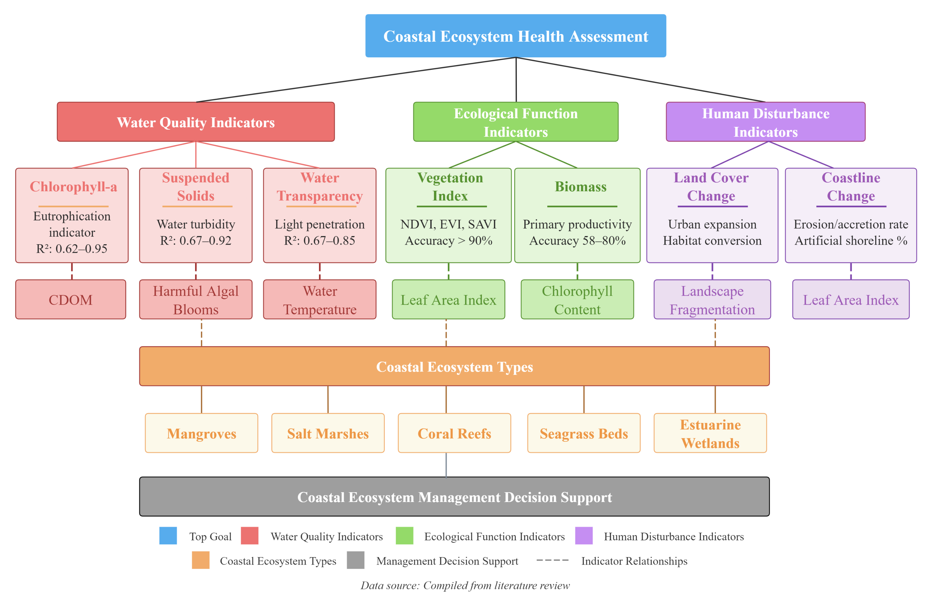
4. Coastal-Ecosystem Health Assessment Indicator System
4.1. Water-Quality Parameter Indicators
4.2. Vegetation and Ecosystem Function Indicators
4.3. Human Disturbance and Landscape Change Indicators
5. Application Cases and Change Analysis
5.1. Typical Ecosystem Health Assessment Cases
5.2. Multi-Temporal Analysis and Change Trends
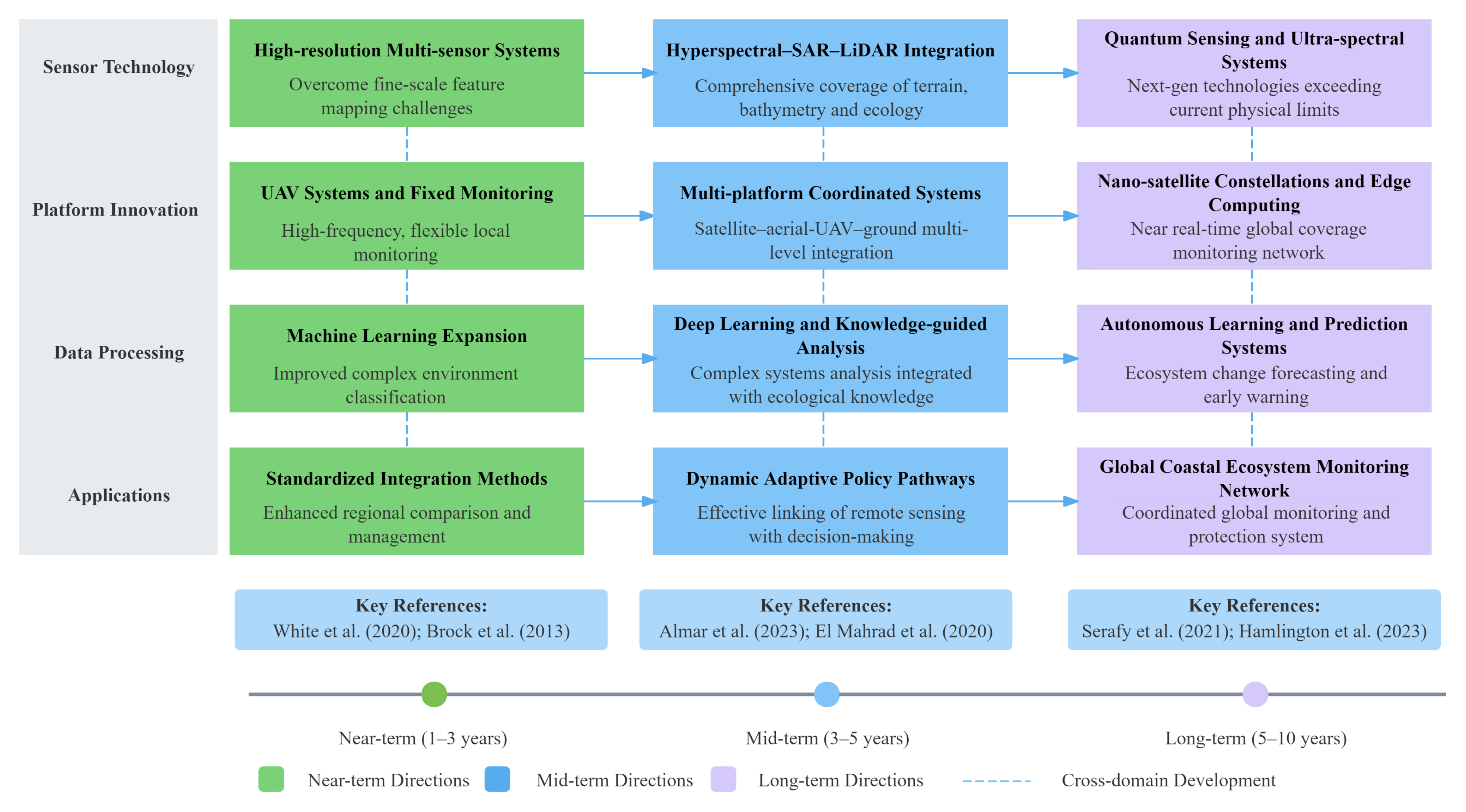
6. Challenges and Prospects
6.1. Prospects for New Technologies and Methods
6.2. Management-Oriented Application Recommendations
7. Conclusions and Prospects
Author Contributions
Funding
Data Availability Statement
Conflicts of Interest
References
- Chen, C.F.; Son, N.T.; Chang, N.B.; Chen, C.R.; Chang, L.Y.; Valdez, M.; Centeno, G.; Thompson, C.A.; Aceituno, J.L. Multi-Decadal Mangrove Forest Change Detection and Prediction in Honduras, Central America, with Landsat Imagery and a Markov Chain Model. Remote Sens. 2013, 5, 6408–6426. [Google Scholar] [CrossRef]
- Liao, J.; Zhen, J.; Zhang, L.; Metternicht, G. Understanding Dynamics of Mangrove Forest on Protected Areas of Hainan Island, China: 30 Years of Evidence from Remote Sensing. Sustainability 2019, 11, 5356. [Google Scholar] [CrossRef]
- Palandro, D.; Andrefouet, S.; Muller-Karger, F.; Dustan, P. Coral Reef Change Detection Using Landsats 5 and 7: A Case Study Using Carysfort Reef in the Florida Keys. In Proceedings of the Igarss 2001, Scanning the Present and Resolving the Future, IEEE 2001 International Geoscience and Remote Sensing Symposium (Cat. No.01ch37217), Sydney, Australia, 9–13 July 2001; Volume 2, pp. 625–627. [Google Scholar] [CrossRef]
- Chen, Y.; Kirwan, M.L. A phenology- and trend-based approach for accurate mapping of sea-level driven coastal forest retreat. Remote Sens. Environ. 2022, 281, 113229. [Google Scholar] [CrossRef]
- Wang, H.; Zhou, Y.; Wu, J.; Wang, C.; Zhang, R.; Xiong, X.; Xu, C. Human activities dominate a staged degradation pattern of coastal tidal wetlands in Jiangsu province, China. Ecol. Indic. 2023, 154, 110579. [Google Scholar] [CrossRef]
- Stelzer, K.; Brockmann, C.; Murphy, D.; Krämer, U. Applicability of Remote Sensing in Monitoring Coastal Zones. In Geographie der Meere und Küsten; Schernewski, G., Dolch, T., Eds.; Coastline Reports; EUCC: Warnemünde, Germany, 2004; Volume 1, pp. 249–253. [Google Scholar]
- Moffett, K.B.; Nardin, W.; Silvestri, S.; Wang, C.; Temmerman, S. Multiple Stable States and Catastrophic Shifts in Coastal Wetlands: Progress, Challenges, and Opportunities in Validating Theory Using Remote Sensing and Other Methods. Remote Sens. 2015, 7, 10184–10226. [Google Scholar] [CrossRef]
- Espriella, M.C.; Lecours, V. Optimizing the Scale of Observation for Intertidal Habitat Classification through Multiscale Analysis. Drones 2022, 6, 140. [Google Scholar] [CrossRef]
- Brock, J.C.; Danielson, J.J.; Purkis, S. Emerging methods for the study of coastal ecosystem landscape structure and change. Int. J. Remote Sens. 2013, 34, 6283–6285. [Google Scholar] [CrossRef]
- El Mahrad, B.; Newton, A.; Icely, J.D.; Kacimi, I.; Abalansa, S.; Snoussi, M. Contribution of Remote Sensing Technologies to a Holistic Coastal and Marine Environmental Management Framework: A Review. Remote Sens. 2020, 12, 2313. [Google Scholar] [CrossRef]
- Maurya, K.; Mahajan, S.; Chaube, N. Remote sensing techniques: Mapping and monitoring of mangrove ecosystem—A review. Complex Intell. Syst. 2021, 7, 2797–2818. [Google Scholar] [CrossRef]
- Chen, J.; Chen, S.; Fu, R.; Wang, C.; Li, D.; Peng, Y.; Wang, L.; Jiang, H.; Zheng, Q. Remote Sensing Estimation of Chlorophyll-A in Case-II Waters of Coastal Areas: Three-Band Model Versus Genetic Algorithm—Artificial Neural Networks Model. IEEE J. Sel. Top. Appl. Earth Obs. Remote Sens. 2021, 14, 3640–3658. [Google Scholar] [CrossRef]
- Castro, I.J.; Dias, J.M.; Lopes, C.L. Assessing Shoreline Changes in Fringing Salt Marshes from Satellite Remote Sensing Data. Remote Sens. 2023, 15, 4475. [Google Scholar] [CrossRef]
- Mu, K.; Tang, C.; Tosi, L.; Li, Y.; Zheng, X.; Donnici, S.; Sun, J.; Liu, J.; Gao, X. Coastline Monitoring and Prediction Based on Long-Term Remote Sensing Data—A Case Study of the Eastern Coast of Laizhou Bay, China. Remote Sens. 2024, 16, 185. [Google Scholar] [CrossRef]
- Bartsch, A.; Ley, S.; Nitze, I.; Pointner, G.; Vieira, G. Feasibility Study for the Application of Synthetic Aperture Radar for Coastal Erosion Rate Quantification Across the Arctic. Front. Environ. Sci. 2020, 8, 143. [Google Scholar] [CrossRef]
- Zhang, Y.; Jing, W.; Deng, Y.; Zhou, W.; Yang, J.; Li, Y.; Cai, Y.; Hu, Y.; Peng, X.; Lan, W.; et al. Water quality parameters retrieval of coastal mariculture ponds based on UAV multispectral remote sensing. Front. Environ. Sci. 2023, 11, 1079397. [Google Scholar] [CrossRef]
- Guo, S.; Sun, B.; Zhang, H.K.; Liu, J.; Chen, J.; Wang, J.; Jiang, X.; Yang, Y. MODIS ocean color product downscaling via spatio-temporal fusion and regression: The case of chlorophyll-a in coastal waters. Int. J. Appl. Earth Obs. Geoinf. 2018, 73, 340–361. [Google Scholar] [CrossRef]
- Yuan, Y.; Meng, X.; Sun, W.; Yang, G.; Wang, L.; Peng, J.; Wang, Y. Multi-Resolution Collaborative Fusion of SAR, Multispectral and Hyperspectral Images for Coastal Wetlands Mapping. Remote Sens. 2022, 14, 3492. [Google Scholar] [CrossRef]
- Almar, R.; Stieglitz, T.; Addo, K.A.; Ba, K.; Ondoa, G.A.; Bergsma, E.W.J.; Bonou, F.; Dada, O.; Angnuureng, D.; Arino, O. Coastal Zone Changes in West Africa: Challenges and Opportunities for Satellite Earth Observations. Surv. Geophys. 2023, 44, 249–275. [Google Scholar] [CrossRef]
- Lunetta, R.S.; Knight, J.F.; Paerl, H.W.; Streicher, J.J.; Peierls, B.L.; Gallo, T.; Lyon, J.G.; Mace, T.H.; Buzzlli, C.P. Measurement of water colour using AVIRIS imagery to assess the potential for an operational monitoring capability in the Pamlico Sound Estuary, USA. Int. J. Remote Sens. 2009, 30, 3291–3314. [Google Scholar] [CrossRef]
- Ali, S.M.; Gupta, A.; Raman, M.; Sahay, A.; Motwani, G.; Muduli, P.R.; Krishna, A.V.; Tirkey, A. Improved estimates of bio-optical parameters in optically complex water using hyperspectral remote sensing data. Int. J. Remote Sens. 2021, 42, 3056–3073. [Google Scholar] [CrossRef]
- Baek, J.Y.; Jo, Y.H.; Kim, W.; Lee, J.S.; Jung, D.; Kim, D.W.; Nam, J. A New Algorithm to Estimate Chlorophyll-A Concentrations in Turbid Yellow Sea Water Using a Multispectral Sensor in a Low-Altitude Remote Sensing System. Remote Sens. 2019, 11, 2257. [Google Scholar] [CrossRef]
- Gai, Y.; Yu, D.; Zhou, Y.; Yang, L.; Chen, C.; Chen, J. An Improved Model for Chlorophyll-a Concentration Retrieval in Coastal Waters Based on UAV-Borne Hyperspectral Imagery: A Case Study in Qingdao, China. Water 2020, 12, 2769. [Google Scholar] [CrossRef]
- Nazeer, M.; Nichol, J.E. Selection of atmospheric correction method and estimation of Chlorophyll-a (Chl-a) in coastal waters of Hong Kong. In Proceedings of the 2014 Third International Workshop on Earth Observation and Remote Sensing Applications (EORSA), Changsha, China, 11–14 June 2014; pp. 374–378. [Google Scholar] [CrossRef]
- Hafeez, S.; Wong, M.S.; Ho, H.C.; Nazeer, M.; Nichol, J.; Abbas, S.; Tang, D.; Lee, K.H.; Pun, L. Comparison of Machine Learning Algorithms for Retrieval of Water Quality Indicators in Case-II Waters: A Case Study of Hong Kong. Remote Sens. 2019, 11, 617. [Google Scholar] [CrossRef]
- Mazzolini, M.; Manzoni, M.; Monti-Guarnieri, A.V.; Petrushevsky, N. SAR-Based Coastline Detection and Monitoring. Int. Arch. Photogramm. Remote Sens. Spat. Inf. Sci. 2021, XLIII-B3-2021, 327–334. [Google Scholar] [CrossRef]
- Salameh, E.; Frappart, F.; Turki, I.; Laignel, B. Intertidal Topography Mapping Using the Waterline Method from Sentinel-1 & -2 Images: The Examples of Arcachon and Veys Bays in France. ISPRS J. Photogramm. Remote Sens. 2020, 163, 98–120. [Google Scholar] [CrossRef]
- Bian, S.; Xie, C.; Tian, B.; Guo, Y.; Zhu, Y.; Yang, Y.; Zhang, M.; Yang, Y.; Ruan, Y. Classification of plants based on time-series SAR coherence and intensity data in Yancheng coastal wetland. Int. J. Remote Sens. 2025, 46, 859–881. [Google Scholar] [CrossRef]
- Segales, J.M.; Paz, E.M.; Cauba, A.G., Jr. A-PoRM SIPLAS: Assessing The Post-Disaster Recovery Of Mangrove Forest In Siargao Island Protected Landscape And Seascape (SIPLAS) Area Using Sentinel-1 SAR Data. Int. Arch. Photogramm. Remote Sens. Spat. Inf. Sci. 2024, XLVIII-5-2024, 105–116. [Google Scholar] [CrossRef]
- Abou El-Magd, I.; Zakzouk, M.; Abdulaziz, A.M.; Ali, E.M. The Potentiality of Operational Mapping of Oil Pollution in the Mediterranean Sea near the Entrance of the Suez Canal Using Sentinel-1 SAR Data. Remote Sens. 2020, 12, 1352. [Google Scholar] [CrossRef]
- Haarpaintner, J.; Davids, C. Mapping Atmospheric Exposure of the Intertidal Zone with Sentinel-1 CSAR in Northern Norway. Remote Sens. 2021, 13, 3354. [Google Scholar] [CrossRef]
- Vásquez-Salazar, R.D.; Cardona-Mesa, A.A.; Valdés-Quintero, J.; Olmos-Severiche, C.; Gómez, L.; Travieso-González, C.M.; Díaz-Paz, J.P.; Espinosa-Ovideo, J.E.; Diez-Rendón, L.; Garavito-González, A.F.; et al. Detection of Coastal Erosion and Progradation in the Colombian ‘Atrato River’ Delta by Using Sentinel-1 Synthetic Aperture Radar Data. Remote Sens. 2024, 16, 552. [Google Scholar] [CrossRef]
- Lamb, B.T.; Tzortziou, M.A.; McDonald, K.C. A Fused Radar–Optical Approach for Mapping Wetlands and Deepwaters of the Mid–Atlantic and Gulf Coast Regions of the United States. Remote Sens. 2021, 13, 2495. [Google Scholar] [CrossRef]
- Zollini, S.; Dominici, D.; Alicandro, M.; Cuevas-González, M.; Angelats, E.; Ribas, F.; Simarro, G. New Methodology for Shoreline Extraction Using Optical and Radar (SAR) Satellite Imagery. J. Mar. Sci. Eng. 2023, 11, 627. [Google Scholar] [CrossRef]
- Wang, W.; Gade, M.; Yang, X. Detection of Bivalve Beds on Exposed Intertidal Flats Using Polarimetric SAR Indicators. Remote Sens. 2017, 9, 1047. [Google Scholar] [CrossRef]
- Li, P.; Zhang, Y.; Liang, C.; Wang, H.; Li, Z. High Spatiotemporal Resolution River Networks Mapping on Catchment Scale Using Satellite Remote Sensing Imagery and DEM Data. Geophys. Res. Lett. 2024, 51, e2023GL107956. [Google Scholar] [CrossRef]
- Dehouck, A.; Lafon, V.; Baghdadi, N.; Marieu, V. Use of optical and radar data in synergy for mapping intertidal flats and coastal salt-marshes (Arcachon lagoon, France). In Proceedings of the 2012 IEEE International Geoscience and Remote Sensing Symposium, Munich, Germany, 22–27 July 2012; pp. 2853–2856. [Google Scholar] [CrossRef]
- Ferrara, C.; Lega, M.; Fusco, G.; Bishop, P.; Endreny, T. Characterization of Terrestrial Discharges into Coastal Waters with Thermal Imagery from a Hierarchical Monitoring Program. Water 2017, 9, 500. [Google Scholar] [CrossRef]
- Allen, T.; Wang, Y.; Gore, B.; Swords, J.; Newcomb, D. Coastal Wetland Mapping Using Time Series SAR Imagery and LIDAR: Alligator River National Wildlife Refuge, North Carolina. In Proceedings of the Pecora 18—Forty Years of Earth Observation…Understanding a Changing World, Herndon, VA, USA, 14–17 November 2011. [Google Scholar]
- Gade, M.; Barale, V.; Snaith, H. Multisensor monitoring of plume dynamics in the northwestern Mediterranean Sea. J. Coast. Conserv. 2003, 9, 91–96. [Google Scholar] [CrossRef]
- Dabrowska-Zielinska, K.; Budzynska, M.; Tomaszewska, M.; Bartold, M.; Gatkowska, M.; Malek, I.; Turlej, K.; Napiorkowska, M. Monitoring Wetlands Ecosystems Using ALOS PALSAR (L-Band, HV) Supplemented by Optical Data: A Case Study of Biebrza Wetlands in Northeast Poland. Remote Sens. 2014, 6, 1605–1633. [Google Scholar] [CrossRef]
- Wicaksono, A.; Khakhim, N.; Pratama, D.; Musthofa, A.; Lazuardi, W. Geometric Accuracy Comparison of Shorelines Derived from Multitemporal Sentinel-2A Imagery with Various Image Spectral Transformations (Case Study: Marine Deposition Coasts in Bantul Regency, Yogyakarta, Indonesia). Int. J. Geoinform. 2021, 17, 27–40. [Google Scholar]
- Bannari, A.; Ali, T.S.; Abahussain, A. The capabilities of Sentinel-MSI (2A/2B) and Landsat-OLI (8/9) in seagrass and algae species differentiation using spectral reflectance. Ocean Sci. 2022, 18, 361–388. [Google Scholar] [CrossRef]
- Agate, J.; Ballinger, R.; Ward, R.D. Satellite remote sensing can provide semi-automated monitoring to aid coastal decision-making. Estuarine, Coast. Shelf Sci. 2024, 298, 108639. [Google Scholar] [CrossRef]
- Lemenkova, P. Artificial Intelligence for Computational Remote Sensing: Quantifying Patterns of Land Cover Types around Cheetham Wetlands, Port Phillip Bay, Australia. J. Mar. Sci. Eng. 2024, 12, 1279. [Google Scholar] [CrossRef]
- Ashphaq, M.; Srivastava, P.K.; Mitra, D. Satellite-Derived Bathymetry in Dynamic Coastal Geomorphological Environments Through Machine Learning Algorithms. Earth Space Sci. 2024, 11, e2024EA003554. [Google Scholar] [CrossRef]
- Feng, Q.; Yang, J.; Zhu, D.; Liu, J.; Guo, H.; Bayartungalag, B.; Li, B. Integrating Multitemporal Sentinel-1/2 Data for Coastal Land Cover Classification Using a Multibranch Convolutional Neural Network: A Case of the Yellow River Delta. Remote Sens. 2019, 11, 1006. [Google Scholar] [CrossRef]
- Liu, P.; Wang, C.; Ye, M.; Han, R. Coastal Zone Classification Based on U-Net and Remote Sensing. Appl. Sci. 2024, 14, 7050. [Google Scholar] [CrossRef]
- Hill, P.R.; Kumar, A.; Temimi, M.; Bull, D.R. HABNet: Machine Learning, Remote Sensing-Based Detection of Harmful Algal Blooms. IEEE J. Sel. Top. Appl. Earth Obs. Remote Sens. 2020, 13, 3229–3239. [Google Scholar] [CrossRef]
- Balogun, A.L.; Yekeen, S.T.; Pradhan, B.; Althuwaynee, O.F. Spatio-Temporal Analysis of Oil Spill Impact and Recovery Pattern of Coastal Vegetation and Wetland Using Multispectral Satellite Landsat 8-OLI Imagery and Machine Learning Models. Remote Sens. 2020, 12, 1225. [Google Scholar] [CrossRef]
- Munizaga, J.; García, M.; Ureta, F.; Novoa, V.; Rojas, O.; Rojas, C. Mapping Coastal Wetlands Using Satellite Imagery and Machine Learning in a Highly Urbanized Landscape. Sustainability 2022, 14, 5700. [Google Scholar] [CrossRef]
- Alevizos, E. A Combined Machine Learning and Residual Analysis Approach for Improved Retrieval of Shallow Bathymetry from Hyperspectral Imagery and Sparse Ground Truth Data. Remote Sens. 2020, 12, 3489. [Google Scholar] [CrossRef]
- Liu, X.; Fatoyinbo, T.E.; Thomas, N.M.; Guan, W.W.; Zhan, Y.; Mondal, P.; Lagomasino, D.; Simard, M.; Trettin, C.C.; Deo, R.; et al. Large-Scale High-Resolution Coastal Mangrove Forests Mapping Across West Africa With Machine Learning Ensemble and Satellite Big Data. Front. Earth Sci. 2021, 8, 560933. [Google Scholar] [CrossRef]
- Zhu, Y.; Li, Z.; Zhao, Z.; Lu, L.; Yang, S.; Wang, Z. Spatio-temporal changes of coastline in Jiaozhou Bay from 1987 to 2022 based on optical and SAR data. Front. Mar. Sci. 2023, 10, 1233410. [Google Scholar] [CrossRef]
- Pahlevan, N.; Smith, B.; Schalles, J.; Binding, C.; Cao, Z.; Ma, R.; Alikas, K.; Kangro, K.; Gurlin, D.; Hà, N.; et al. Seamless retrievals of chlorophyll-a from Sentinel-2 (MSI) and Sentinel-3 (OLCI) in inland and coastal waters: A machine-learning approach. Remote Sens. Environ. 2020, 240, 111604. [Google Scholar] [CrossRef]
- Zaabar, N.; Niculescu, S.; Kamel, M.M. Application of Convolutional Neural Networks With Object-Based Image Analysis for Land Cover and Land Use Mapping in Coastal Areas: A Case Study in Ain Témouchent, Algeria. IEEE J. Sel. Top. Appl. Earth Obs. Remote Sens. 2022, 15, 5177–5189. [Google Scholar] [CrossRef]
- Devlin, J.M.; da Silva, T.E.; Petus, C.; Wenger, A.; Zeh, D.; Tracey, D.; Álvarez-Romero, G.J.; Brodie, J. Combining in-situ water quality and remotely sensed data across spatial and temporal scales to measure variability in wet season chlorophyll-a: Great Barrier Reef lagoon (Queensland, Australia). Ecol Process 2013, 2, 31. [Google Scholar] [CrossRef]
- Donatelli, C.; Passalacqua, P.; Jensen, D.; Oliver-Cabrera, T.; Jones, C.E.; Fagherazzi, S. Spatial Variability in Salt Marsh Drainage Controlled by Small Scale Topography. J. Geophys. Res. Earth Surf. 2023, 128, e2023JF007219. [Google Scholar] [CrossRef]
- Bishop-Taylor, R.; Sagar, S.; Lymburner, L.; Alam, I.; Sixsmith, J. Sub-Pixel Waterline Extraction: Characterising Accuracy and Sensitivity to Indices and Spectra. Remote Sens. 2019, 11, 2984. [Google Scholar] [CrossRef]
- Moreno-Madriñán, M.J.; Fischer, A.M. Performance of the MODIS FLH algorithm in estuarine waters: A multi-year (2003–2010) analysis from Tampa Bay, Florida (USA). Int. J. Remote Sens. 2013, 34, 6467–6483. [Google Scholar] [CrossRef]
- Abbas, M.M.; Melesse, A.M.; Scinto, L.J.; Rehage, J.S. Satellite Estimation of Chlorophyll-a Using Moderate Resolution Imaging Spectroradiometer (MODIS) Sensor in Shallow Coastal Water Bodies: Validation and Improvement. Water 2019, 11, 1621. [Google Scholar] [CrossRef]
- Han, B.; Loisel, H.; Vantrepotte, V.; Mériaux, X.; Bryère, P.; Ouillon, S.; Dessailly, D.; Xing, Q.; Zhu, J. Development of a Semi-Analytical Algorithm for the Retrieval of Suspended Particulate Matter from Remote Sensing over Clear to Very Turbid Waters. Remote Sens. 2016, 8, 211. [Google Scholar] [CrossRef]
- Novoa, S.; Doxaran, D.; Ody, A.; Vanhellemont, Q.; Lafon, V.; Lubac, B.; Gernez, P. Atmospheric Corrections and Multi-Conditional Algorithm for Multi-Sensor Remote Sensing of Suspended Particulate Matter in Low-to-High Turbidity Levels Coastal Waters. Remote Sens. 2017, 9, 61. [Google Scholar] [CrossRef]
- Zhou, X.; Marani, M.; Albertson, J.D.; Silvestri, S. Hyperspectral and Multispectral Retrieval of Suspended Sediment in Shallow Coastal Waters Using Semi-Analytical and Empirical Methods. Remote Sens. 2017, 9, 393. [Google Scholar] [CrossRef]
- Cavalli, R.M. Local, Daily, and Total Bio-Optical Models of Coastal Waters of Manfredonia Gulf Applied to Simulated Data of CHRIS, Landsat TM, MIVIS, MODIS, and PRISMA Sensors for Evaluating the Error. Remote Sens. 2020, 12, 1428. [Google Scholar] [CrossRef]
- Sukojo, B.M.; Arindi, Y.N. Analisa Perubahan Kerapatan Mangrove Berdasarkan Nilai Normalized Difference Vegetation Index Menggunakan Citra Landsat 8 (Studi Kasus: Pesisir Utara Surabaya). Geoid 2019, 14, 1–5. [Google Scholar] [CrossRef]
- Kang, X.; Yan, L.; Zhang, X.; Li, Y.; Tian, D.; Peng, C.; Wu, H.; Wang, J.; Zhong, L. Modeling Gross Primary Production of a Typical Coastal Wetland in China Using MODIS Time Series and CO2 Eddy Flux Tower Data. Remote Sens. 2018, 10, 708. [Google Scholar] [CrossRef]
- Meng, L.; Huang, Y.; Zhu, N.; Chen, Z.; Li, X. Mapping properties of vegetation in a tidal salt marsh from multi-spectral satellite imagery using the SCOPE model. Int. J. Remote Sens. 2021, 42, 422–444. [Google Scholar] [CrossRef]
- Rummell, A.J.; Leon, J.X.; Borland, H.P.; Elliott, B.B.; Gilby, B.L.; Henderson, C.J.; Olds, A.D. Watching the Saltmarsh Grow: A High-Resolution Remote Sensing Approach to Quantify the Effects of Wetland Restoration. Remote Sens. 2022, 14, 4559. [Google Scholar] [CrossRef]
- Ramsey, E., III; Rangoonwala, A. Canopy Reflectance Related to Marsh Dieback Onset and Progression in Coastal Louisiana. Photogramm. Eng. Remote Sens. 2006, 72, 641–652. [Google Scholar] [CrossRef]
- Benevides, J.; Silva, A.; Benevides, D.J.; Bezerra, L.E. Comparative Space-Temporal Study of the Spectral Response of the Vegetation of the APA of the Curu River Estuary and Surroundings Using Multispectral Images. Geosaberes 2023, 14, 1–20. [Google Scholar] [CrossRef]
- Salcedo, J.M.; Alhama, I.; Alcaraz, M.; Álvarez-Rogel, J.; Jiménez-Valera, J.A. Using Remote Sensing to Assess the Vegetation Cover of a Protected Salt Marsh Subjected to Artificial Recharge and Groundwater Abstractions during the Period 1925–2022 (Alicante, SE Spain). Sustainability 2024, 16, 973. [Google Scholar] [CrossRef]
- Ballanti, L.; Byrd, K.B.; Woo, I.; Ellings, C. Remote Sensing for Wetland Mapping and Historical Change Detection at the Nisqually River Delta. Sustainability 2017, 9, 1919. [Google Scholar] [CrossRef]
- Callaghan, K.; Engelbrecht, J.; Kemp, J. The Use of Landsat and Aerial Photography for the Assessment of Coastal Erosion and Erosion Susceptibility in False Bay, South Africa. South. Afr. J. Geomat. 2015, 4, 65–79. [Google Scholar] [CrossRef]
- Ayalke, Z.G.; Şişman, A.; Akpinar, K. Shoreline extraction and analyzing the effect of coastal structures on shoreline changing with remote sensing and geographic information system: Case of Samsun, Turkey. Reg. Stud. Mar. Sci. 2023, 61, 102883. [Google Scholar] [CrossRef]
- Li, J.; Liu, Y.; Pu, R.; Yuan, Q.; Shi, X.; Guo, Q.; Song, X. Coastline and landscape changes in bay areas caused by human activities: A comparative analysis of Xiangshan Bay, China and Tampa Bay, USA. J. Geogr. Sci. 2018, 28, 1127–1151. [Google Scholar] [CrossRef]
- Chu, L.; Oloo, F.; Sudmanns, M.; Tiede, D.; Hölbling, D.; Blaschke, T.; Teleoaca, I. Monitoring long-term shoreline dynamics and human activities in the Hangzhou Bay, China, combining daytime and nighttime EO data. Big Earth Data 2020, 4, 242–264. [Google Scholar] [CrossRef]
- Niculescu, S.; Lardeux, C.; Hanganu, J. Alteration and Remediation of Coastal Wetland Ecosystems in the Danube Delta: A Remote-Sensing Approach. In Coastal Wetlands: Alteration and Remediation; Finkl, C.W., Makowski, C., Eds.; Springer International Publishing: Cham, Switzerland, 2017; pp. 513–553. [Google Scholar] [CrossRef]
- Kumar, T.; Kaur, P.; Chandrasekar, K.; Bandyopadhyay, S. Aviris-ng Hyperspectral Data For Mapping Mangrove Forests And Their Health Spatially: A Case Study Of Indian Sundarbans. J. Trop. For. Sci. 2020, 32, 317–331. [Google Scholar] [CrossRef]
- Bhadra, T.; Banerjee, S.; Ghosh, S.; Saha, A.; Mukherjee, K.; Sardar, R.; Roy, S.; Das, R. Monitoring The Mangroves Of Indian Sundarbans Using Geospatial Techniques. Int. Arch. Photogramm. Remote Sens. Spat. Inf. Sci. 2023, XLVIII-1/W2-2023, 405–412. [Google Scholar] [CrossRef]
- Campbell, A.D. Monitoring Salt Marsh Condition and Change with Satellite Remote Sensing. Ph.D. Dissertation, University of Rhode Island, Kingston, RI, USA, 2018. Open Access Dissertations. p. 793. [Google Scholar]
- Lanceman, D.; Sadat-Noori, M.; Gaston, T.; Drummond, C.; Glamore, W. Blue carbon ecosystem monitoring using remote sensing reveals wetland restoration pathways. Front. Environ. Sci. 2022, 10, 924221. [Google Scholar] [CrossRef]
- Collin, A.; Planes, S. Enhancing Coral Health Detection Using Spectral Diversity Indices from WorldView-2 Imagery and Machine Learners. Remote Sens. 2012, 4, 3244–3264. [Google Scholar] [CrossRef]
- Leiper, I.A.; Phinn, S.R.; Roelfsema, C.M.; Joyce, K.E.; Dekker, A.G. Mapping Coral Reef Benthos, Substrates, and Bathymetry, Using Compact Airborne Spectrographic Imager (CASI) Data. Remote Sens. 2014, 6, 6423–6445. [Google Scholar] [CrossRef]
- Cingano, P.; Vuerich, M.; Petruzzellis, F.; Orzan, L.; Trotta, G.; Casolo, V.; Asquini, E.; Bacaro, G.; Boscutti, F. Seagrasses on the move: Tracing the multi-decadal species distribution trends in lagoon meadows using Landsat imagery. Ecol. Inform. 2024, 82, 102685. [Google Scholar] [CrossRef]
- Yang, X.; Zhu, Z.; Qiu, S.; Kroeger, K.D.; Zhu, Z.; Covington, S. Detection and characterization of coastal tidal wetland change in the northeastern US using Landsat time series. Remote Sens. Environ. 2022, 276, 113047. [Google Scholar] [CrossRef]
- Dittmann, S.; Mosley, L.; Stangoulis, J.; Nguyen, V.L.; Beaumont, K.; Dang, T.; Guan, H.; Gutierrez-Jurado, K.; Lam-Gordillo, O.; McGrath, A. Effects of Extreme Salinity Stress on a Temperate Mangrove Ecosystem. Front. For. Glob. Change 2022, 5, 859283. [Google Scholar] [CrossRef]
- Zuo, X.L.; Yu, K.F.; Qin, B.N.; Duan, X.P.; Yao, Z.F.; Su, F.Z. Deriving fine-scale patterns of sea surface temperature in coral reef habitats using the Landsat 8 thermal infrared sensor. Front. Mar. Sci. 2023, 10, 1293414. [Google Scholar] [CrossRef]
- Yamano, H.; Tamura, M.; Kunii, Y.; Hidaka, M. Hyperspectral Remote Sensing and Radiative Transfer Simulation as a Tool for Monitoring Coral Reef Health. Mar. Technol. Soc. J. 2002, 36, 4–13. [Google Scholar] [CrossRef]
- Wang, Y.; Wang, X.; Khan, S.; Zhou, D.; Ke, Y. Evaluation of mangrove restoration effectiveness using remote sensing indices—A case study in Guangxi Shankou Mangrove National Natural Reserve, China. Front. Mar. Sci. 2023, 10, 1280373. [Google Scholar] [CrossRef]
- Peng, J.; Liu, S.; Lu, W.; Liu, M.; Feng, S.; Cong, P. Continuous Change Mapping to Understand Wetland Quantity and Quality Evolution and Driving Forces: A Case Study in the Liao River Estuary from 1986 to 2018. Remote Sens. 2021, 13, 4900. [Google Scholar] [CrossRef]
- Williamson, M.J.; Tebbs, E.J.; Thompson, H.J.; Dawson, T.P.; Head, C.E.I.; Jacoby, D.M.P. Application of Earth Observation Data and Google Earth Engine for Monitoring Coral Reef Exposure to Environmental Stressors. Preprints 2021. [Google Scholar] [CrossRef]
- Santos, L.C.M.; Cunha-Lignon, M.; Schaeffer-Novelli, Y.; Cintrón-Molero, G. Long-term effects of oil pollution in mangrove forests (Baixada Santista, Southeast Brazil) detected using a GIS-based multitemporal analysis of aerial photographs. Braz. J. Oceanogr. 2012, 60, 159–170. [Google Scholar] [CrossRef]
- Dewidar, K.M.; Frihy, O.E. Automated techniques for quantification of beach change rates using Landsat series along the North-eastern Nile Delta, Egypt. J. Oceanogr. Mar. Sci. 2010, 1, 28–39. [Google Scholar]
- Tran Thi, V.; Tien Thi Xuan, A.; Phan Nguyen, H.; Dahdouh-Guebas, F.; Koedam, N. Application of remote sensing and GIS for detection of long-term mangrove shoreline changes in Mui Ca Mau, Vietnam. Biogeosciences 2014, 11, 3781–3795. [Google Scholar] [CrossRef]
- Zoysa, S.; Basnayake, V.; Samarasinghe, J.T.; Gunathilake, M.B.; Kantamaneni, K.; Muttil, N.; Pawar, U.; Rathnayake, U. Analysis of Multi-Temporal Shoreline Changes Due to a Harbor Using Remote Sensing Data and GIS Techniques. Sustainability 2023, 15, 7651. [Google Scholar] [CrossRef]
- Rondon, M.; Ewane, E.B.; Abdullah, M.M.; Watt, M.S.; Blanton, A.; Abulibdeh, A.; Burt, J.A.; Rogers, K.; Ali, T.; Reef, R.; et al. Remote sensing-based assessment of mangrove ecosystems in the Gulf Cooperation Council countries: A systematic review. Front. Mar. Sci. 2023, 10, 1241928. [Google Scholar] [CrossRef]
- Biçe, K.; Schalles, J.; Sheldon, J.E.; Alber, M.; Meile, C. Temporal patterns and causal drivers of aboveground plant biomass in a coastal wetland: Insights from time-series analyses. Front. Mar. Sci. 2023, 10, 1130958. [Google Scholar] [CrossRef]
- Marzialetti, F.; Cesarini, G.; Acosta, A.; Battisti, C. Testing effectiveness in nature reserve management using GIS-based tools: A 25 years monitoring of land use change in a Mediterranean coastal wetland. Wetl. Ecol. Manag. 2024, 32, 423–435. [Google Scholar] [CrossRef]
- White, L.; Ryerson, R.A.; Pasher, J.; Duffe, J. State of Science Assessment of Remote Sensing of Great Lakes Coastal Wetlands: Responding to an Operational Requirement. Remote Sens. 2020, 12, 3024. [Google Scholar] [CrossRef]
- Splinter, K.D.; Harley, M.D.; Turner, I.L. Remote Sensing Is Changing Our View of the Coast: Insights from 40 Years of Monitoring at Narrabeen-Collaroy, Australia. Remote Sens. 2018, 10, 1744. [Google Scholar] [CrossRef]
- El Serafy, G.Y.; Schaeffer, B.A.; Neely, M.B.; Spinosa, A.; Odermatt, D.; Weathers, K.C.; Baracchini, T.; Bouffard, D.; Carvalho, L.; Conmy, R.N.; et al. Integrating Inland and Coastal Water Quality Data for Actionable Knowledge. Remote Sens. 2021, 13, 2899. [Google Scholar] [CrossRef]
- Hamlington, B.D.; Tripathi, A.; Rounce, D.R.; Weathers, M.; Adams, K.H.; Blackwood, C.; Carter, J.; Collini, R.C.; Engeman, L.; Haasnoot, M.; et al. Satellite monitoring for coastal dynamic adaptation policy pathways. Clim. Risk Manag. 2023, 42, 100555. [Google Scholar] [CrossRef]
- Cavanaugh, K.C.; Bell, T.; Costa, M.; Eddy, N.E.; Gendall, L.; Gleason, M.G.; Hessing-Lewis, M.; Martone, R.; McPherson, M.; Pontier, O.; et al. A Review of the Opportunities and Challenges for Using Remote Sensing for Management of Surface-Canopy Forming Kelps. Front. Mar. Sci. 2021, 8, 753531. [Google Scholar] [CrossRef]
- Politi, E.; Paterson, S.K.; Scarrott, R.; Tuohy, E.; O’Mahony, C.; Cámaro-García, W.C. Earth observation applications for coastal sustainability: Potential and challenges for implementation. Anthr. Coasts 2019, 2, 306–329. [Google Scholar] [CrossRef]

| Satellite Platform | Sensor | Spatial Resolution (m) | Temporal Resolution (Days) | Spectral Range | Spectral Resolution | Coastal Application Advantages | Main Limitations |
|---|---|---|---|---|---|---|---|
| Optical Remote-Sensing Systems | |||||||
| Landsat 8/9 | OLI/TIRS | 30 (Vis-NIR) 15 (Pan) 100 (Thermal) | 16 (single) 8 (combined) | 0.43–12.51 m | 11 bands | Rich historical data; long-term coastline monitoring; medium resolution for regional assessment. | Cloud coverage; lower temporal resolution; limited water penetration. |
| Sentinel-2 | MSI | 10 (Visible) 20 (Red Edge) 60 (Atm. corr.) | 5 (dual sat.) | 0.44–2.19 m | 13 bands | Red edge bands for vegetation; high temporal resolution; detailed analysis;free data. | Less history (2015+); no thermal bands; cloud cover effects. |
| MODIS | Terra/Aqua | 250 (B1–2) 500 (B3–7) 1000 (Others) | 1 | 0.4–14.4 m | 36 bands | Daily observation; long time series; wide-area monitoring; water-quality dynamics. | Low spatial resolution; mixed pixels; not for small-scale studies. |
| WorldView-2/3 | WV110 | WV-2: 0.46 (Pan) 1.84 (MS) WV-3: 0.31 (Pan) 1.24 (MS) | WV-2: 2.5–5 WV-3: 1.1 (point) | 0.4–1.04 m | 8 bands (WV-2) 16 bands (WV-3) | Ultra-high resolution; detailed features; small area studies; water depth. | High cost; small coverage; unstable acquisition; complex processing. |
| Sentinel-3 | OLCI | 300 | ≤2 (dual sat.) | 0.4–1.02 m | 21 bands | Ocean color optimized; global monitoring; high frequency; water-quality accuracy. | Lower spatial resolution; mixed coastal pixels; land boundary effects. |
| UAV Systems | Multi/ RGB | 0.01–0.2 | Flexible | 0.4–0.9 m | 4–6 bands | Ultra-high resolution; flexible; below clouds; small area details. | Limited coverage; wind constraints; regulations; processing workload. |
| Radar Remote-Sensing Systems | |||||||
| Sentinel-1 | C-SAR | 5 × 20 (IW) | 6 (dual sat.) | C-band (5.4 GHz) | VV, VH, HH, HV | All-weather; cloud penetration; coastline/wetland monitoring; tidal observation. | Speckle noise; complex interpretation; processing requirements. |
| ALOS-2 | PALSAR-2 | 3–10 (High) 100 (ScanSAR) | 14 | L-band (1.2 GHz) | Single/ Dual/ Quad pol | Strong penetration; mangrove/wetland monitoring; biomass; deformation. | Low temporal resolution; high cost; processing requirements. |
| Algorithm Type | Specific Algorithm | Application Scenarios | Accuracy Assessment | Data Requirements | Main Advantages | Main Limitations | Typical Studies |
|---|---|---|---|---|---|---|---|
| Traditional machine learning | Random forest | Land cover classification; wetland mapping; water-quality parameter estimation. | Overall accuracy: 90–96.80% | Medium-scale training samples; multi-source features | Strong capability in handling high-dimensional data; resistance to overfitting; provides variable importance assessment; high computational efficiency. | Limited capability in complex boundary classification; relatively weak interpretability. | Agate et al. [44] Balogun et al. [50] Munizaga et al. [51] |
| Support vector machine (SVM) | Land cover classification; water-quality parameter inversion; mangrove monitoring. | Overall accuracy: up to 97.6% R value: approximately 0.9 | Smaller sample sets; moderate feature dimensions | Excellent performance with small samples; robust boundary decisions; can handle non-linear problems through kernel functions. | Higher computational complexity; difficult parameter optimization; limited capacity for large-scale data processing. | Lemenkova [45] Hafeez et al. [25] | |
| Gaussian process regression (GPR) | Bathymetry; parameter inversion; coastal topography. | : up to 0.97 RMSE: as low as 1.23 m | Small to medium-scale training samples; high-quality labels | Provides prediction uncertainty estimates; adapts to non-linear relationships; excellent interpolation performance. | Computational cost increases rapidly with sample size; difficulty handling large datasets. | Ashphaq et al. [46] Alevizos [52] | |
| Ensemble learning | Mangrove mapping; wetland classification; coastline change. | Overall accuracy: 95–99% | Multi-source data; medium-sized training samples | Integrates advantages of multiple algorithms; improves classification prediction accuracy; strong robustness. | High computational resource requirements; complex parameter tuning; potential for overfitting. | Liu et al. [53] | |
| Deep learning | Convolutional neural network (CNN) | Land cover classification; coastal zone classification; water-quality monitoring. | Overall accuracy: 93.78% | Large training samples; high computational resources | Automatic feature extraction; utilization of spatial context; strong ability to process complex multi-source data. | Requires large training datasets; high computational resource demands; black-box characteristics. | Feng et al. [47] Liu et al. [48] |
| U-Net | Coastal zone classification; wetland mapping; coastline extraction. | Overall accuracy: 93.65% | Medium training samples; high-resolution imagery | Strong semantic segmentation capability; accurate boundary preservation; multi-scale feature fusion. | Complex training process; difficult model tuning; risk of overfitting. | Liu et al. [48] Zhu et al. [54] | |
| Hybrid deep networks (CNN-LSTM) | Harmful algal bloom detection; spatiotemporal dynamic analysis; change prediction. | Overall accuracy: 91% | Time-series data; large sample size | Combines spatial features with time series; dynamic prediction capability; multi-modal data integration. | High network complexity; long training cycles; difficult parameter optimization. | Hill et al. [49] | |
| Mixture density networks (MDN) | Chlorophyll-a retrieval; water-quality parameter estimation. | MAE and bias reduced by 40–60% | Large multi-source training data | Provides probabilistic distribution predictions; uncertainty quantification; adapts to complex non-linear relationships. | Complex network structure; difficult to understand and interpret; high computational cost. | Pahlevan et al. [55] | |
| Deep learning | Hybrid methods (CNN + OBIA) | Coastal land-use mapping; complex environment classification. | Overall accuracy: 93.5% | High-resolution imagery; segmentation parameters. | Combines object and pixel advantages; hierarchical analysis; strong adaptability to heterogeneous landscapes. | Complex implementation; sensitive segmentation parameters; difficult method standardization. | Zaabar et al. [56] |
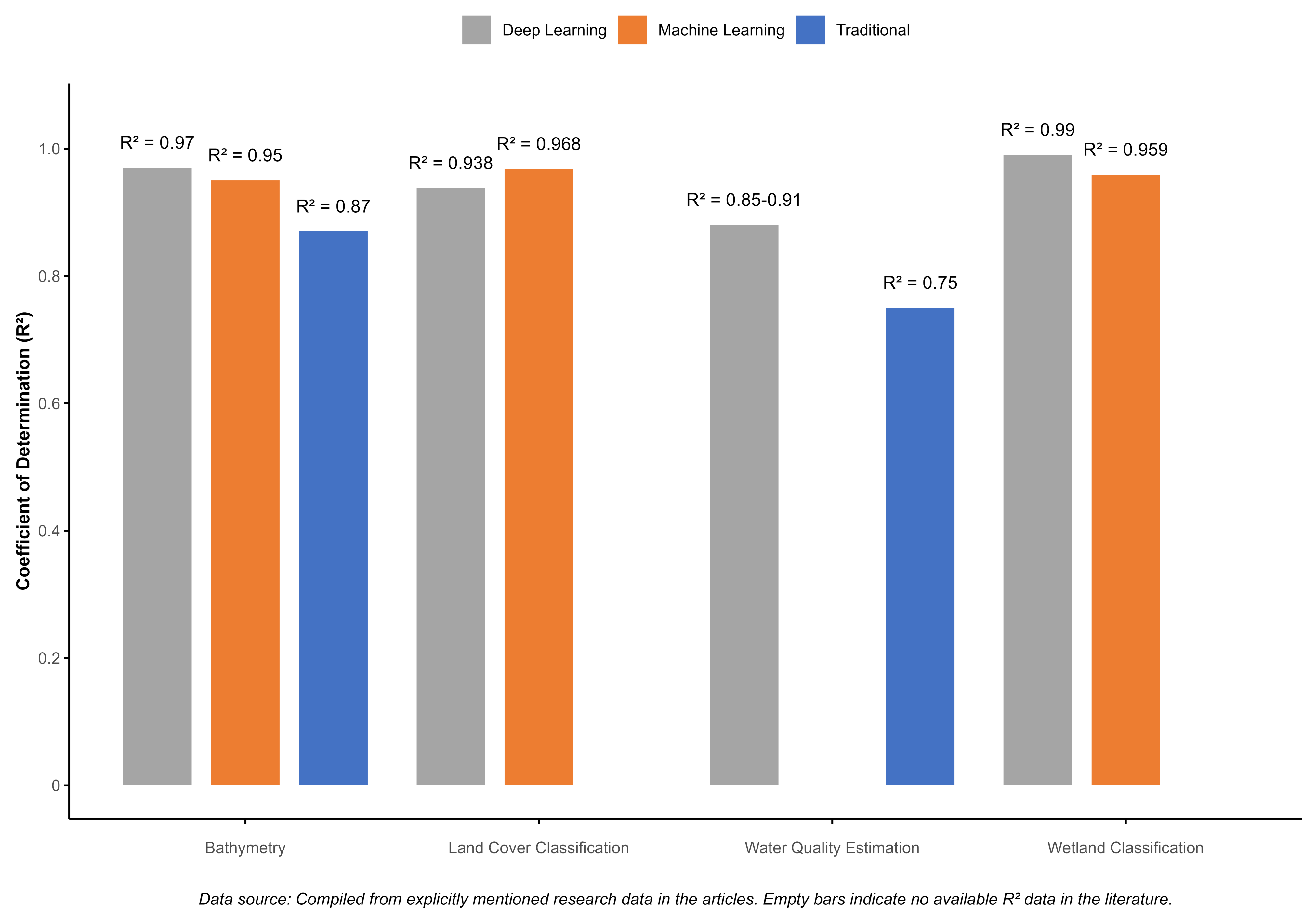
| Application scenario comparison | Bathymetry | Traditional methods: = 0.87 Gaussian process regression: = 0.95–0.97 | Gaussian process regression and deep learning perform better in complex terrains and turbid waters; better handling of non-linear relationships; provides uncertainty estimates. | ||||
| Land-cover classification | Traditional methods: 85–90% CNN methods: >93% | CNN-based methods show significant advantages in processing spatial context; better performance in complex and mixed pixel environments; but require more computational resources and training data. | |||||
| Water-quality parameter estimation | Traditional empirical methods: = 0.7–0.8 Machine-learning methods: = 0.85–0.91 | Ensemble methods and deep learning better capture complex relationships; improved estimation accuracy in turbid waters; reduced bias; but require model structure adjustments for different water body types. | |||||
| Indicator Category | Specific Indicators | Calculation Method/Remote- Sensing Data Source | Application Accuracy | Applicable Ecosystems | Advantages | Limitations |
|---|---|---|---|---|---|---|
| Water-quality indicators | Chlorophyll-a (Chl-a) | Blue/green ratio method; red/near-infrared ratio method; fluorescence line height (FLH); machine-learning models. | – | Estuaries; shallow seas; coral reefs; lakes. | Eutrophication status assessment; primary productivity indication; water biological activity evaluation. | Accuracy decreases in turbid waters; affected by suspended solids; requires regionalized algorithms. |
| Suspended matter (TSM/SPM/TSS) | Single-band or band ratio methods; semi-analytical algorithms; multi-condition algorithms; machine-learning-based models. | – RMSE = 3.93–12.7 mg/L | Estuaries; tidal flats; shallow seas; harbors. | Sediment dynamics monitoring; turbidity assessment; human activity impact analysis. | Saturation in high-concentration waters; optimal model selection needed for concentration ranges. | |
| Water transparency (SD/turbidity) | Direct estimation of Secchi disk depth; indirect estimation based on Chl-a and suspended matter. | – | Seagrass beds; coral reefs; clear coastal waters. | Underwater light condition assessment; underwater ecosystem health evaluation. | Lower accuracy; affected by multiple factors; indirect measurement characteristics. | |
| Vegetation and ecosystem function indicators | Vegetation indices (NDVI/EVI/ SAVI) | NDVI = (NIR − Red)/(NIR + Red) EVI = 2.5 × [(NIR − Red)/(NIR + 6 × Red − 7.5 × Blue + 1)] SAVI = (NIR − Red)/(NIR + Red + L) × (1 + L) | Detection accuracy >90% | Mangroves; salt marshes; wetlands; coastal vegetation. | Vegetation vigor assessment; photosynthetic efficiency indication; ecosystem function evaluation. | NDVI saturates in C affected by soil background; sensitive to tidal state. |
| Biomass estimation | Empirical relationships based on NDVI; radar backscattering coefficient-based;LiDAR point cloud analysis. | Accuracy 58–80% Percentage cover conversion = 0.89–0.96 | Mangroves; salt marshes; seagrass; wetlands. | Carbon sequestration assessment; productivity indication; structural complexity analysis. | Saturation in high biomass areas; spatial heterogeneity impact; field calibration needed. | |
| Leaf area index (LAI) | Inversion based on vegetation indices; radiation transfer models; machine-learning methods. | = 0.539 NRMSE = 0.32 | Mangroves; dalt marshes; coastal vegetation. | Photosynthetic surface area assessment; ecosystem function indicator; canopy structure analysis. | Significantly affected by tides; reduced accuracy in closed canopies; field validation required. | |
| Ecosystem productivity (GPP/fPAR) | Correlation analysis between EVI and gross primary productivity; fraction of photosynthetically active radiation absorption estimation. | = 0.65 (GPP-EVI) | Salt marshes; wetlands; mangroves. | Ecosystem functional state assessment; carbon cycle analysis; health status indication. | Auxiliary meteorological data needed; large regional differences in model parameters; seasonal fluctuations. | |
| Human disturbance and landscape change indicators | Land cover/land-use change | Multi-temporal remote-sensing classification; change detection; supervised/unsupervised classification; object-based classification. | Overall accuracy 80–95% | All coastal ecosystems. | Landscape transformation assessment; urbanization impact analysis; habitat loss monitoring. | Mixed pixel problems; non-uniform classification systems; temporal consistency difficulties. |
| Coastline change | Waterline method; multi-temporal image analysis; digital shoreline analysis system (DSAS); NDVI/MNDWI threshold method. | Average accuracy ≈ 12.63 m detection rate ≈ 96% | Beaches; headlands; estuaries; intertidal zones. | Erosion/accretion assessment; sea-level rise impact analysis; coastal engineering effect monitoring. | Heavily influenced by tidal state; ambiguous definition; seasonal change interference. | |
| Landscape fragmentation | Landscape ecology index calculation; patch density; edge density; connectivity indices. | Dependent on base classification accuracy | Mangroves; coastal wetlands; estuarine systems. | Habitat integrity assessment; ecosystem connectivity analysis; human disturbance evaluation. | Spatial resolution limitations; subjective edge definition; difficult ecological meaning interpretation. | |
| Nighttime light intensity | DMSP-OLS/VIIRS nighttime light data analysis; multi-temporal change detection. | Used as proxy indicator of human activity intensity | Urbanized coasts; tourist coastlines; ports. | Urban expansion monitoring; development intensity assessment; spatiotemporal pattern analysis of human activities. | Lower spatial resolution; light spillover effect; cannot distinguish activity types. |
| Ecosystem Type | Preferred Remote- Sensing Technology | Key Monitoring Indicators | Monitoring Accuracy | Main Challenges | Typical Application Cases |
|---|---|---|---|---|---|
| Mangrove ecosystem | High-resolution multispectral | Vegetation indices (EVI, NDII, PRI, CRI1, VOG1, and MCARI); canopy coverage; health status. | 59% of regions classified as healthiest 11% classified as less healthy | Difficulty in species differentiation; tidal state influences; mixed pixel issues. | Kumar et al. [79]: AVIRIS-NG hyperspectral data (425 bands, 5 m resolution) for classification and assessment of Indian mangroves. |
| SAR (L-band) | Tree height; biomass; structural parameters; sediment characteristics; moisture conditions. | Overall accuracy: 89.79% Kappa coefficient: 0.858 | Speckle noise interference; complex interpretation of backscattering; professional requirements for data processing. | Bian et al. [28]: Time-series SAR coherence and intensity analysis for wetland vegetation classification. | |
| Multi-source fusion Methods | Vegetation indices (NDVI, SAVI, OSAVI, and TDVI); species trends; ecological health status. | Net mangrove loss: 11.9% Mangrove gain: 3.9% Other accuracy data not specifically provided | Temporal inconsistency of data sources; complex fusion algorithms; validation difficulties. | Bhadra et al. [80]: combining Sentinel-2 and Landsat 9, finding decreasing trends in freshwater-loving mangroves and increasing trends in salt-tolerant mangroves. | |
| Salt marsh ecosystem | Sub-meter resolution optical imagery | Salt marsh area; coastline changes; vegetation coverage; temporal change rates. | Annual change rate: decreased from 13.4 ha/year to 2.1 ha/year loss | High cost; cloud cover limitations; rough surface shadow issues. | Campbell [81]: Quickbird-2 and WorldView-2 sub-meter resolution imagery for monitoring salt marshes in Jamaica Bay, USA. |
| Multispectral UAV | Micro-topography; hydrological patterns; vegetation health status; restoration process monitoring. | Spatial resolution: 3–12 cm Salt marsh area increase: 142% (within four years) | Small coverage area; flexible deployment; can operate below cloud cover. | Lanceman et al. [82]: multispectral UAV imagery (3–12 cm resolution) for monitoring wetland restoration processes. | |
| Long time-series Landsat | NDVI thresholds; coastline dynamics; salt marsh changes; spatial differences. | Regional retreat: >66 m Regional advance: approximately 2 m | Resolution limitations; severe mixed pixel issues; temporary water body confusion. | Castro et al. [13]: NDVI threshold method for 38-year (1984–2022) coastline change analysis of salt marshes in Aveiro Lagoon, Portugal. | |
| Coral reef ecosystem | High-resolution satellite imagery | Coral coverage; coral bleaching degree; coral types; spectral diversity index. | Health status classification accuracy: 96% | Water absorption and scattering; water depth limitations; complex atmospheric correction. | Collin and Planes [83]: WorldView-2 high-resolution satellite imagery (0.5 m resolution), combined with spectral diversity index. |
| Hyperspectral sensors | Coral health status; pigment changes; algal coverage; surface reflection characteristics. | Specific accuracy data not clearly provided | Massive data volume; complex processing; feature extraction difficulties. | Leiper [84]: hyperspectral sensor data outperforms conventional multispectral data in capturing subtle health changes in coral reefs. | |
| Long-term time-series monitoring | Long-term changes in coral coverage; bleaching event impacts; recovery conditions. | Coral coverage decline: 79–92% | Sensor consistency; water-quality change interference; tidal state impacts. | Palandro et al. [3]: Landsat time-series data (1983–1999) recording significant decline in coral coverage. | |
| Seagrass bed ecosystem | Multispectral remote sensing | Coverage area; density; distribution patterns; biomass. | Seagrass coverage area increase: 39% (14.16 km²) | Water depth limitations; water transparency dependency; substrate interference. | Cingano et al. [85]: Landsat 5 and 8 data, using random forest algorithm for analysis of seagrass communities in Grado and Marano Lagoons, Italy. |
| Specialized band combinations | Blue, green, and near-infrared wavelengths; differentiation between algae and seagrass. | Percentage cover conversion : 0.96 and 0.89 | Strong site specificity; local calibration needed; seasonal change interference. | Bannari et al. [43]: study of various vegetation indices found blue, green, and near-infrared wavelengths particularly important for seagrass and algae detection. | |
| Estuary and intertidal systems | SAR and optical fusion | Intertidal zone range; sediment types; hydrodynamic processes; waterline extraction. | Waterline method accuracy error: 19–25 cm | Strong tidal phase dependency; topographic slope influence; SAR speckle interference. | Salameh et al. [27]: improved waterline method showing only 19–25 cm error compared to LiDAR. |
| Continuous change detection algorithms | Dynamic changes; land-cover transitions; topographic evolution; ecological transition zones. | Annual reduction trend: approximately 2.6 km²/year | Short-term fluctuation interference; seasonal noise; algorithm complexity. | Yang et al. [86]: DECODE algorithm for analyzing changes in tidal wetlands in the northeastern United States from 1986 to 2020. |
Disclaimer/Publisher’s Note: The statements, opinions and data contained in all publications are solely those of the individual author(s) and contributor(s) and not of MDPI and/or the editor(s). MDPI and/or the editor(s) disclaim responsibility for any injury to people or property resulting from any ideas, methods, instructions or products referred to in the content. |
© 2025 by the authors. Licensee MDPI, Basel, Switzerland. This article is an open access article distributed under the terms and conditions of the Creative Commons Attribution (CC BY) license (https://creativecommons.org/licenses/by/4.0/).
Share and Cite
Zhao, L.; Fan, X.; Xiao, S. Remote-Sensing Indicators and Methods for Coastal-Ecosystem Health Assessment: A Review of Progress, Challenges, and Future Directions. Water 2025, 17, 1971. https://doi.org/10.3390/w17131971
Zhao L, Fan X, Xiao S. Remote-Sensing Indicators and Methods for Coastal-Ecosystem Health Assessment: A Review of Progress, Challenges, and Future Directions. Water. 2025; 17(13):1971. https://doi.org/10.3390/w17131971
Chicago/Turabian StyleZhao, Lili, Xuncheng Fan, and Shihong Xiao. 2025. "Remote-Sensing Indicators and Methods for Coastal-Ecosystem Health Assessment: A Review of Progress, Challenges, and Future Directions" Water 17, no. 13: 1971. https://doi.org/10.3390/w17131971
APA StyleZhao, L., Fan, X., & Xiao, S. (2025). Remote-Sensing Indicators and Methods for Coastal-Ecosystem Health Assessment: A Review of Progress, Challenges, and Future Directions. Water, 17(13), 1971. https://doi.org/10.3390/w17131971