Comprehensive Flood Risk Assessment for Quang Tri Province
Abstract
1. Introduction
2. Data Collection and Methodology
2.1. Study Area
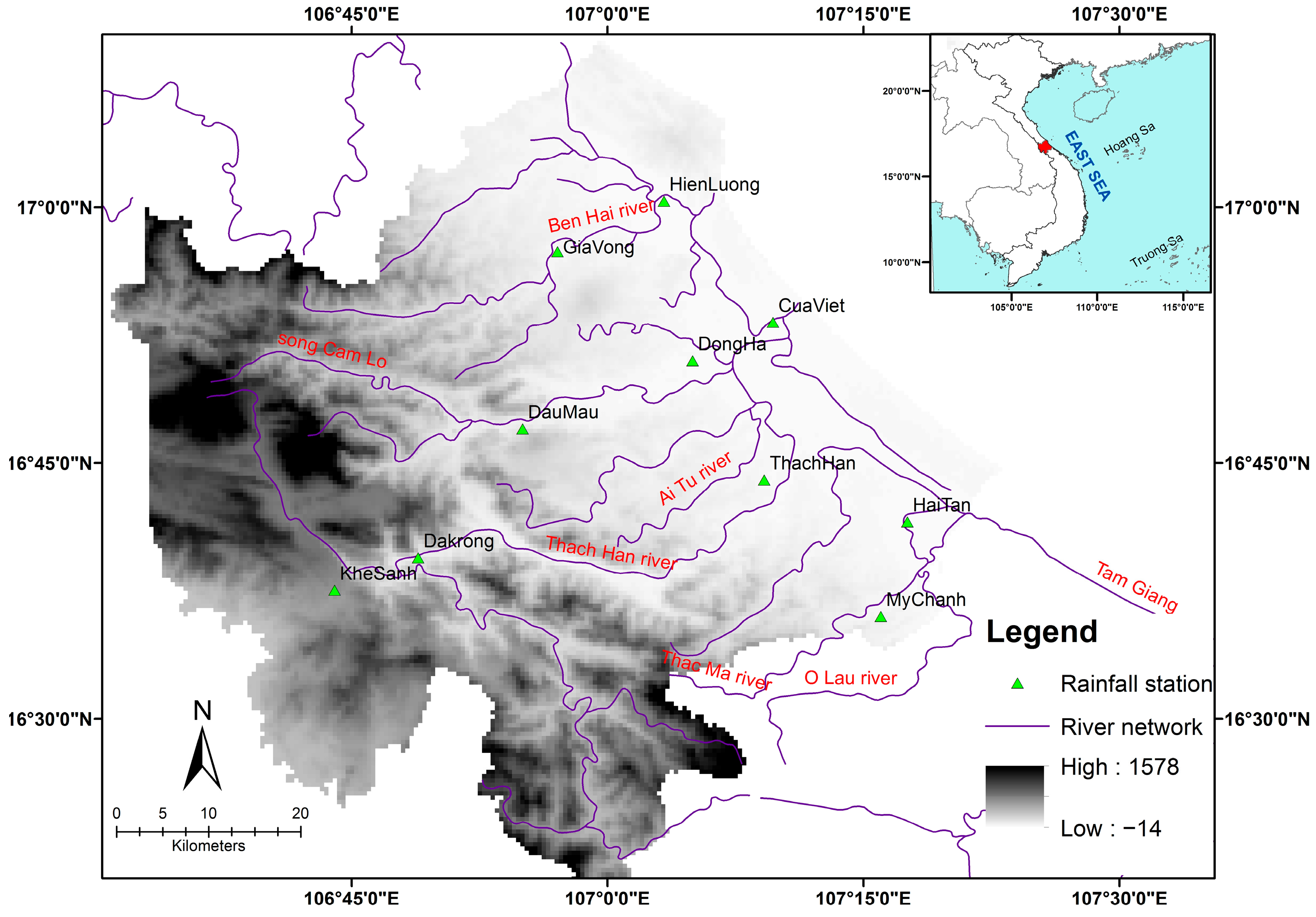
- Ben Hai River System: Originating from the northeastern slope of Lu Bu Mountain at 705 m, it flows through Vu Con, Ben Thao, and Xuan Hoa, before reaching the sea at Cua Tung. It comprises the Ben Hai River and Ben Xe tributary, with a total length of 76 km and a basin area of 923 km2.
- Thach Han River System (Quang Tri River): The largest system in the province, it originates from the Ca Kut range (Vietnam-Laos border), stretching 169 km with a basin area of 2727 km2. It includes tributaries like Hieu, Vinh Phuoc, Nhung, Ai Tu, and Rao Quan rivers, characterized by meandering flows (sinuosity coefficient of 3.5).
- O Lau River System (My Chanh): Located in the south, partially in Thua Thien Hue Province, it flows through the Lac estuary into Tam Giang Lagoon, with its main tributaries being My Chanh and O Khe rivers. It spans 65 km, with a basin area of 931 km2, an average flow of 44 m3/s, and a river density of 0.81 km/km2.
2.2. Data Collection
2.2.1. Geographic Data
2.2.2. Socio-Economic Data
2.2.3. Field Surveys
2.3. Methodology
2.3.1. Hydrologic–Hydraulic Model
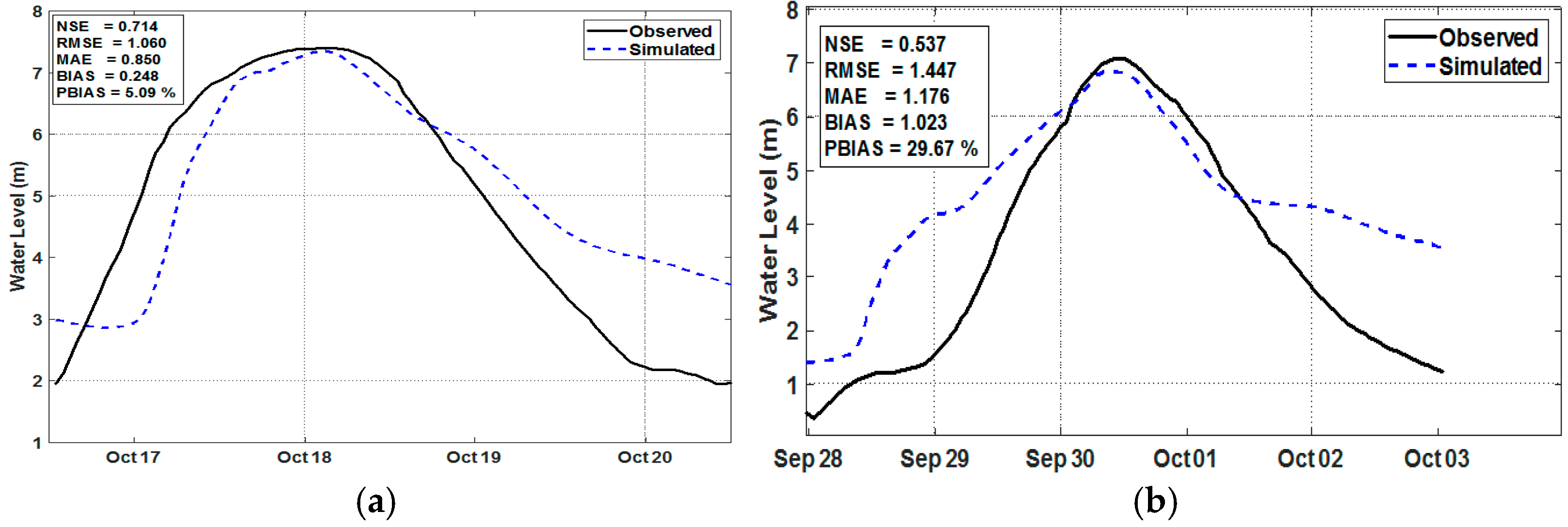
2.3.2. Model Calibration
| = | Measured value at time I; | |
| = | Calculated value at time I; | |
| n | = | Number of pairs of comparison points between actual measured data and calculated data; |
| = | Average measured value. |
2.3.3. Selection of Indicators
2.3.4. Normalization of Data
- Since indicators have different units and magnitudes, they were normalized to dimensionless values between 0 and 1 for comparison across spatial units.
- For positively correlated indicators,
- For negatively correlated indicators,
2.3.5. Weight Calculation for Component Indicators
3. Results and Discussion
3.1. Hydrologic–Hydraulic Model Performance
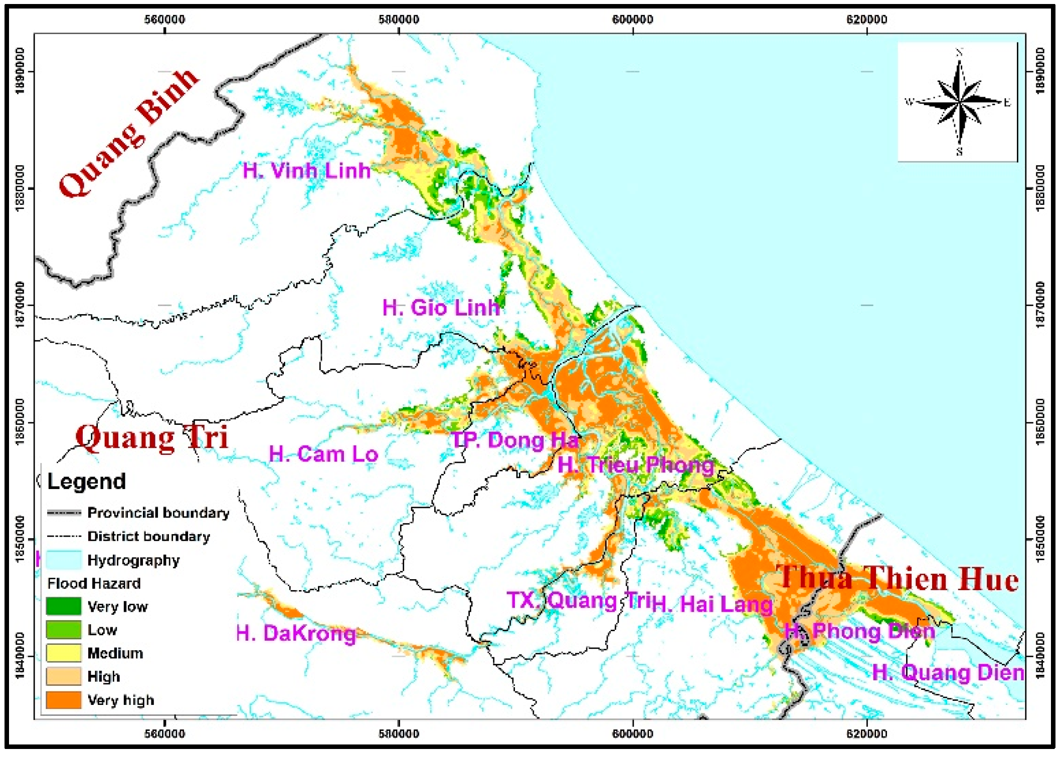
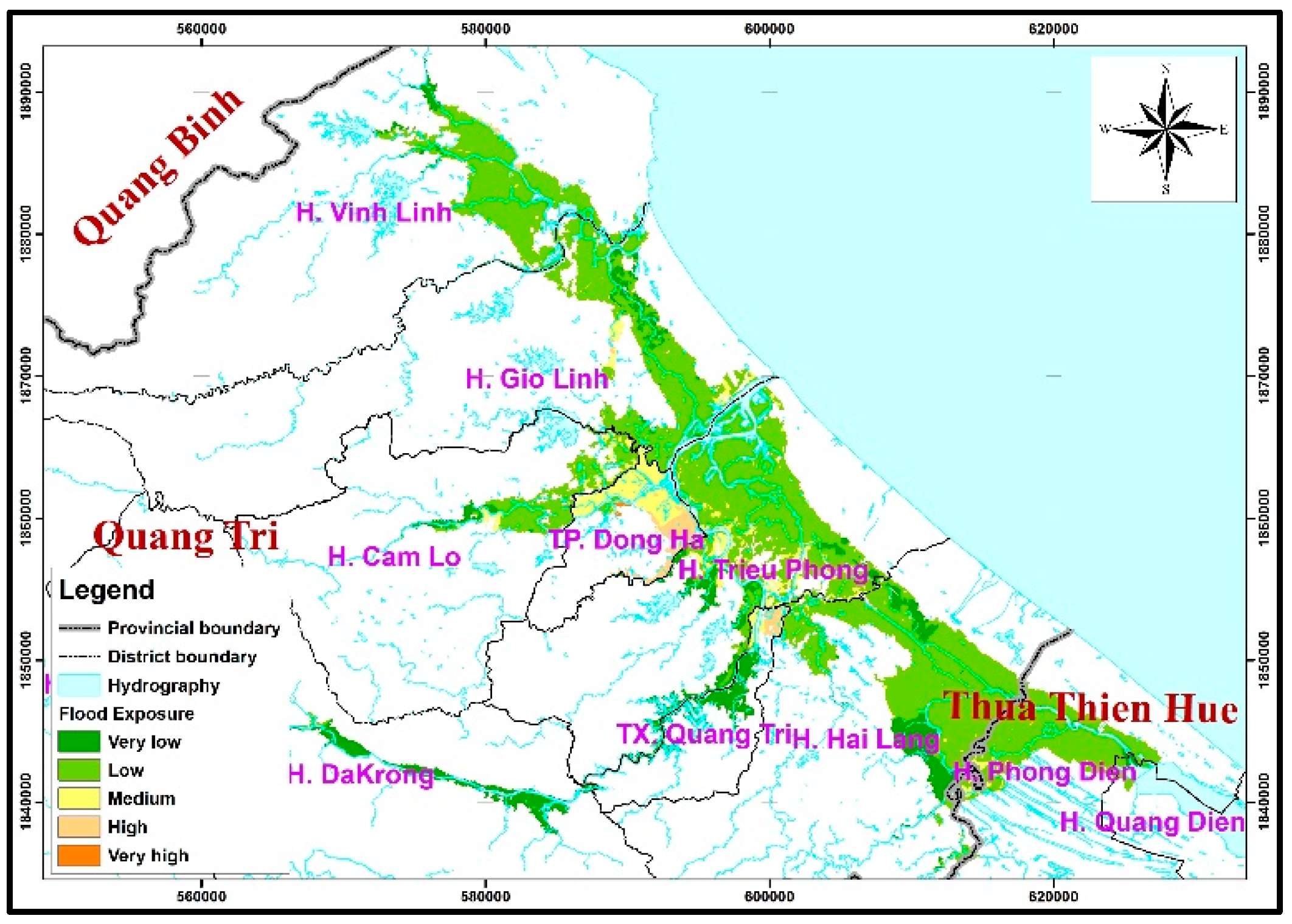
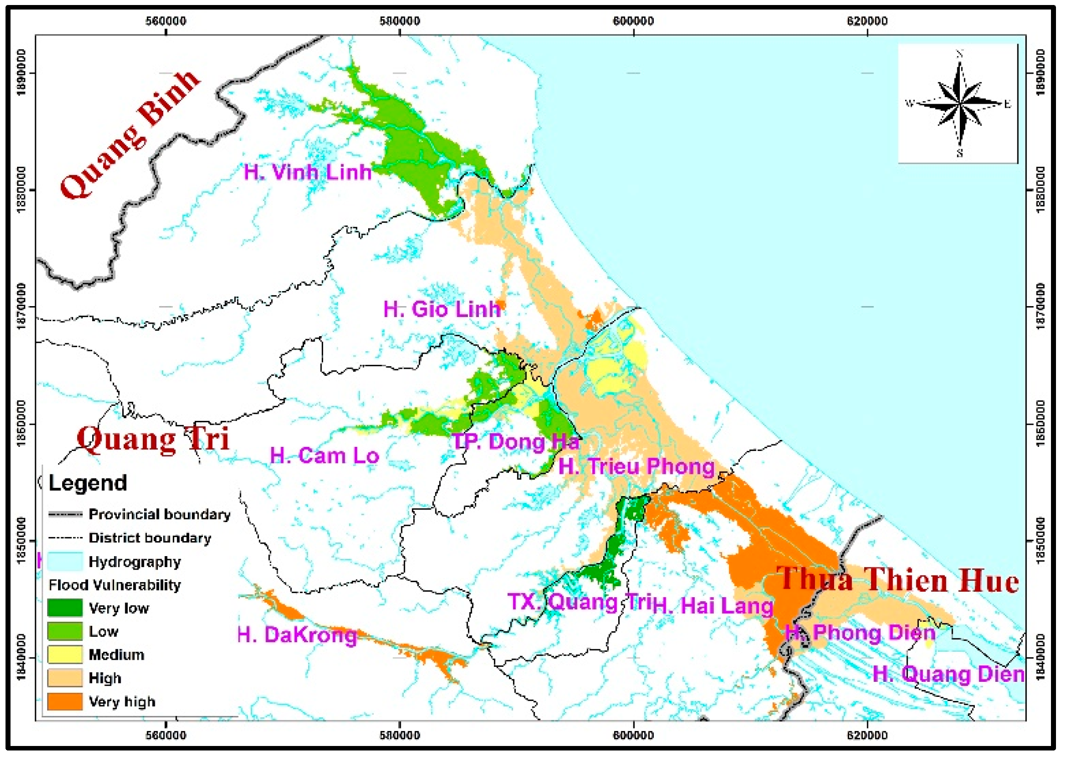
3.2. Flood Risk
3.3. Discussions
4. Conclusions
Author Contributions
Funding
Data Availability Statement
Acknowledgments
Conflicts of Interest
References
- IPCC. The Physical Science Basis: Working Group I Contribution to the Fifth Assessment Report of the Intergovernmental Panel on Climate Change; Cambridge University Press: Cambridge, UK, 2013; Available online: https://www.ipcc.ch/report/ar5/wg1 (accessed on 25 June 2025).
- MONRE. Climate Change and Sea Level Rise Scenarios for Vietnam; Ministry of Natural resources and Environment: Hanoi, Vietnam, 2016. [Google Scholar]
- GFDRR. Country Profile: Vietnam. 2011. Available online: https://www.gfdrr.org/en/publication/fiscal-impact-natural-disasters-vietnam (accessed on 10 March 2025).
- World Bank. Vietnam: Toward a Safe, Clean, and Resilient Water System. 2019. Available online: https://www.worldbank.org/en/country/vietnam/publication/vietnam-toward-a-safe-clean-and-resilient-water-system (accessed on 18 December 2024).
- Nguyen, H.D. Flood susceptibility assessment using hybrid machine learning and remote sensing in Quang Tri province, Vietnam. Trans. GIS 2022, 26, 2776–2801. [Google Scholar] [CrossRef]
- Nguyen, H.D.; Dang, D.K.; Nguyen, Y.N.; Van, C.P.; Truong, Q.H.; Bui, Q.T.; Petrisor, A.I. A framework for flood depth using hydrodynamic modeling and machine learning in the coastal province of Vietnam. Vietnam J. Earth Sci. 2023, 45, 456–478. [Google Scholar] [CrossRef] [PubMed]
- Chi, V.T.; Quang, D.N.; Tinh, N.X.; Tanaka, H. Estimation of floodwater depth in Quang Tri province using Sentinel-1 data. Tohoku J. Nat. Disaster Sci. 2022, 58, 99–104. [Google Scholar]
- Van, C.T.; Tuan, N.C.; Son, N.T.; Tri, D.Q.; Anh, L.N.; Tran, D.D. Flood vulnerability assessment and mapping: A case of Ben Hai-Thach Han River basin in Vietnam. Int. J. Disaster Risk Reduct. 2022, 75, 102969. [Google Scholar] [CrossRef]
- King, D.; Davidson, J.; Anderson-Berry, L. Disaster mitigation and societal impacts. In Global Perspectives on Tropical Cyclones; World Scientific Publishing: Singapore, 2010; pp. 409–436. [Google Scholar] [CrossRef]
- Sahoo, B.; Bhaskaran, P.K. Multi-hazard risk assessment of coastal vulnerability from tropical cyclones—A GIS based approach for the Odisha coast. J. Environ. Manag. 2018, 206, 1166–1178. [Google Scholar] [CrossRef] [PubMed]
- Zhang, K.; Shalehy, H.; Ezaz, G.T.; Chakraborty, A.; Mohib, K.M.; Liu, L. An integrated flood risk assessment approach based on coupled hydrological-hydraulic modeling and bottom-up hazard vulnerability analysis. Environ. Model. Softw. 2022, 148, 105279. [Google Scholar] [CrossRef]
- Zhang, J.; Chen, Y. Risk assessment of flood disaster induced by typhoon rainstorms in Guangdong province, China. Sustainability 2019, 11, 2738. [Google Scholar] [CrossRef]
- Kaźmierczak, A.; Cavan, G. Surface water flooding risk to urban communities: Analysis of vulnerability, hazard and exposure. Landsc. Urban Plan. 2011, 103, 185–197. [Google Scholar] [CrossRef]
- Pham, B.T.; Luu, C.; Van Dao, D.; Van Phong, T.; Nguyen, H.D.; Van Le, H.; von Meding, J.; Prakash, I. Flood risk assessment using deep learning integrated with multi-criteria decision analysis. Knowl.-Based Syst. 2021, 219, 106899. [Google Scholar] [CrossRef]
- da Silva, L.B.L.; Alencar, M.H.; de Almeida, A.T. Exploring global sensitivity analysis on a risk-based MCDM/A model to support urban adaptation policies against floods. Int. J. Disaster Risk Reduct. 2022, 73, 102898. [Google Scholar] [CrossRef]
- Nguyen, M.D.; Babel, M.S.; Luong, H.T. Evaluation of food risk parameters in the day river flood diversion area, Red River delta, Vietnam. Nat. Hazards 2011, 56, 169–194. [Google Scholar]
- Trinh, V. Flood Risk Assessment for Thach Han River Basin, Quang Tri Province. Master’s Thesis, University of Science, VNU, Hanoi, Vietnam, 2010. [Google Scholar]
- Can, T.V. Research on Establishing Scientific Basis for Assessing Flood Vulnerability in Vu Gia—Thu Bon River Basin to Serve Disaster Prevention Planning. Ph.D. Thesis, University of Science, VNU, Hanoi, Vietnam, 2015. [Google Scholar]
- Iyengar, N.S.; Sudarshan, P. A Method of Classifying Regions from Multivariate Data. Econ. Political Wkly. 1982, 17, 2047–2052. [Google Scholar]
- Huynh, T.L.H. Research on Scientific and Technological Solutions for Multi-Disaster Management, Develop Decision Support Tools to Respond to Multi-Disasters, and Apply Them on a Pilot Basis in the Coastal Area of Central Central Vietnam; National Project Code Nr. KC.08.24/16-20; Science and Technology Publishing House: Hanoi, Vietnam, 2020. [Google Scholar]
- Nguyen, X.H. Research on Building a Warning System for Natural Disaster Risk Levels of Storms and Tropical Depressions Based on Hydrometeorological Forecast Bulletins and Testing Application for the North Central Region; National Project Code Nr. KC.08.36/16-20; Science and Technology Publishing House: Hanoi, Vietnam, 2021. [Google Scholar]
- Giang, V.T.; Bac, D.K.; Chi, V.K.; Minh, N.D.; Van Liem, N.; Van Bao, D.; Nga, P.T.P. Assessment of flood vulnerability in coastal areas of Ha Tinh province. J. Geospat. Humanit. Res. 2021, 4, 2021. (In Vietnamese) [Google Scholar]
- DHI 2017 MIKE User and Reference Manual. Denmark. Available online: https://www.dhigroup.com/ (accessed on 20 March 2024).
- Nash, J.E.; Sutcliffe, J.V. River flow forecasting through conceptual models part I—A discussion of principles. J. Hydrol. 1970, 10, 282–290. [Google Scholar] [CrossRef]
- Moriasi, D.N.; Arnold, J.G.; van Liew, M.W.; Bingner, R.L.; Harmel, R.D.; Veith, T.L. Model Evaluation Guidelines for Systematic Quantification of Accuracy in Watershed Simulations. Trans. ASABE 2007, 50, 885–900. [Google Scholar] [CrossRef]
- Gupta, H.V.; Sorooshian, S.; Yapo, P.O. Status of automatic calibration for hydrologic models: Comparison with multilevel expert calibration. J. Hydrol. Eng. 1999, 4, 135–143. [Google Scholar] [CrossRef]
- UNDP. Viet Nam Special Report on Managing the Risks of Extreme Events and Disasters to Advance Climate Change Adaptation. 2015. Available online: https://www.vn.undp.org/content/vietnam/en/home/library/environment_climate/viet_nam_special_report_on_managing_the_risks_of_extreme_events_and_disasters.html (accessed on 15 December 2024).
- Nguyen, C.C.; Nguyen, B.Q.; Le, X.C.; Pham, L.T.; Vo, D.P.; Nguyen, T.H.; Vo, N.D. Urban inundation forecasting based on hydraulic models coupling MIKE Flood and MIKE Urban: A case study of Tam Ky City, Vietnam. River 2023, 2, 518–529. [Google Scholar] [CrossRef]
- Ngan, N.T.; Trung, N.H. Application of GIS and SWMM model to assess urban flooding in Hung Phu 1 Residential Area of Cai Rang District. J. Earth Sci. Environ. 2024, 8, 953–964. [Google Scholar]
- Lu, M.; Ni, T.; Ying, X. Urban flood risk analysis based on GIS and SWMM: A case study in Dujiangyan. In Advances in Measurement Technology, Disaster Prevention and Mitigation, Proceedings of the 3rd International Conference on Measurement Technology, Disaster Prevention and Mitigation (MTDPM 2022), Zhengzhou, China, 27–29 May 2022; CRC Press: Boca Raton, FL, USA, 2022; pp. 104–109. [Google Scholar]
| NSE Value | The Goodness of Fit |
|---|---|
| NSE ≤ 0.40 | Bad |
| 0.40 < NSE ≤ 0.70 | Average |
| 0.70 < NSE ≤ 0.85 | Good |
| 0.85 < NSE ≤ 1.00 | Excellent |
| Group | Criteria | Indicator | Unit |
|---|---|---|---|
| Hazard (H) | Flooding (H1) | Inundation depth (H11) | m |
| Velocity (H12) | m/s | ||
| Time of inundation (H13) | day | ||
| Exposure (E) | Population (E1) | Population density (E11) | person/km2 |
| Lan use (E2) | Lan use (E21) | ha | |
| Infrastructure (E3) | Number of schools at all level (E31) | school | |
| Traffic density (E33) | km/km2 | ||
| Sensitivity (S) | Agriculture (S1) | Large agricultural products (S11) | Million tons |
| Fisheries output (S12) | Million tons | ||
| Society (S2) | Rate of poor and near-poor households (S21) | % | |
| Proportion of elderly and children (0–15 years old; over 64 years old) (S22) | % | ||
| Housing conditions (S3) | Percentage of solid houses (S31) | % | |
| Temporary housing rate (S32) | % | ||
| Adaptive Capacity (AC) | Economy (AC1) | Per capita income (AC11) | Million VNĐ per year |
| Food crop yield (AC21) | Ton/hectare | ||
| Health (AC2) | Number of medical staff (AC21) | People/10,000 people | |
| Number of hospital beds (AC22) | Beds/10,000 people | ||
| Percentage of people participating in insurance (AC23) | % | ||
| Education (AC3) | Ratio of high school graduates to total population (AC31) | % | |
| Information, communication (AC4) | Percentage of mobile phone users (AC41) | % | |
| Percentage of people using the internet (AC42) | % | ||
| Disaster prevention (AC5) | Number of safe places for Evacuation (e.g., community housing) (AC51) | point | |
| Propaganda and training on disaster prevention and mitigation (AC52) | point |
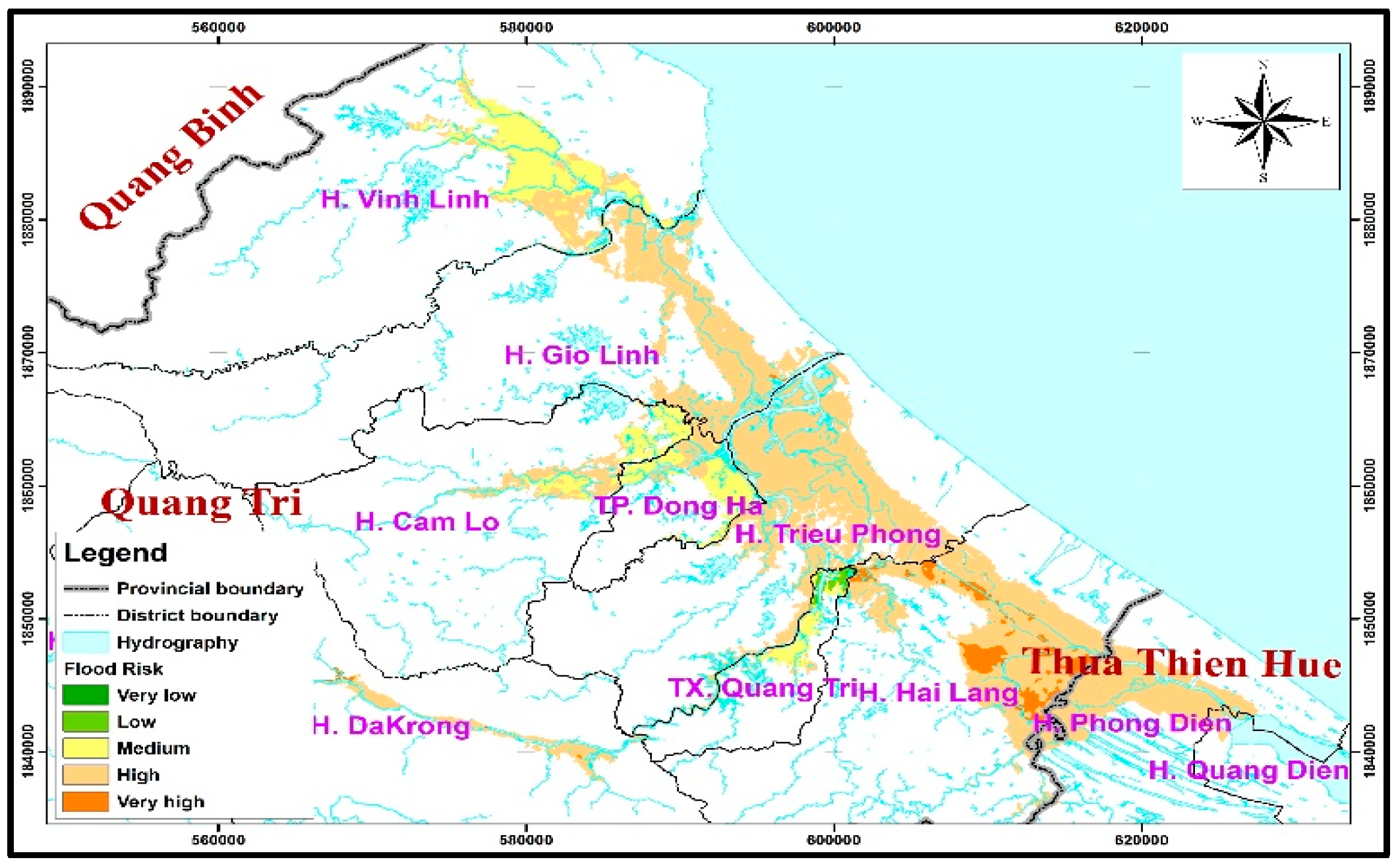
| Risk Level | Level | Area (ha) | Percentage (%) |
|---|---|---|---|
| Very low-level risk zone | 1 | 8.16 | 0.02 |
| Low-level risk zone | 2 | 259.24 | 0.54 |
| Medium-level risk zone | 3 | 7951.00 | 16.54 |
| High-level risk zone | 4 | 38,030.08 | 79.13 |
| Very high-level risk zone | 5 | 1809.28 | 3.76 |
Disclaimer/Publisher’s Note: The statements, opinions and data contained in all publications are solely those of the individual author(s) and contributor(s) and not of MDPI and/or the editor(s). MDPI and/or the editor(s) disclaim responsibility for any injury to people or property resulting from any ideas, methods, instructions or products referred to in the content. |
© 2025 by the authors. Licensee MDPI, Basel, Switzerland. This article is an open access article distributed under the terms and conditions of the Creative Commons Attribution (CC BY) license (https://creativecommons.org/licenses/by/4.0/).
Share and Cite
Thanh, N.T.; Hung, N.T.; Cuong, T.V.; Cuong, V.D.; Quan, T.Q.; Dang, N.M. Comprehensive Flood Risk Assessment for Quang Tri Province. Water 2025, 17, 1958. https://doi.org/10.3390/w17131958
Thanh NT, Hung NT, Cuong TV, Cuong VD, Quan TQ, Dang NM. Comprehensive Flood Risk Assessment for Quang Tri Province. Water. 2025; 17(13):1958. https://doi.org/10.3390/w17131958
Chicago/Turabian StyleThanh, Nguyen Tien, Nguyen Thanh Hung, To Vinh Cuong, Vu Dinh Cuong, Trieu Quang Quan, and Nguyen Mai Dang. 2025. "Comprehensive Flood Risk Assessment for Quang Tri Province" Water 17, no. 13: 1958. https://doi.org/10.3390/w17131958
APA StyleThanh, N. T., Hung, N. T., Cuong, T. V., Cuong, V. D., Quan, T. Q., & Dang, N. M. (2025). Comprehensive Flood Risk Assessment for Quang Tri Province. Water, 17(13), 1958. https://doi.org/10.3390/w17131958


