Abstract
Geothermal systems play a crucial role in understanding Earth’s heat dynamics. The Yunkai Uplift in southern China exemplifies a geothermally rich region characterized by ancient lithologies and high heat flow. This study investigates the geochemical characteristics of geothermal waters in the Yunkai Uplift. Both geothermal and non-thermal water samples were collected along the Xinyi–Lianjiang (XL) Fault Zone and the Cenxi–Luchuan (CL) Fault Zone flanking the core of the Yunkai Mountains. Analytical techniques were applied to examine major ions, trace elements, and dissolved CO2 and H2, as well as isotopic characteristics of O, H, Sr, C, and He in water samples, allowing for an investigation of geothermal reservoir temperatures, circulation depths, and mixing processes. The findings indicate that most geothermal waters are influenced by water–rock interactions primarily dominated by granites. The region’s diverse lithologies, change from ancient Caledonian granites and medium–high-grade metamorphic rocks in the central hinterland (XL Fault Zone) to low-grade metamorphic rocks and sedimentary rocks in the western margin (CL Fault Zone). The chemical compositions of geothermal waters are influenced through mixing contacts between diverse rocks of varying ages, leading to distinct geochemical characteristics. Notably, δ13CCO2 values reveal that while some samples exhibit significant contributions from metamorphic CO2 sources, others are characterized by organic CO2 origins. Regional heat flow results from the upwelling of mantle magma, supplemented by radioactive heat generated from crustal granites. Isotopic evidence from δ2H and δ18O indicates that the geothermal waters originate from atmospheric sources, recharged by precipitation in the northern Yunkai Mountains. After infiltrating to specific depths, meteoric waters are heated to temperatures ranging from about 76.4 °C to 178.5 °C before ascending through the XL and CL Fault Zones under buoyancy forces. During their upward migration, geothermal waters undergo significant mixing with cold groundwater (54–92%) in shallow strata. As part of the western boundary of the Yunkai Uplift, the CL Fault Zone may extend deeper into the crust or even interact with the upper mantle but exhibits weaker hydrothermal activities than the XL Fault Zone. The XL Fault Zone, however, is enriched with highly heat-generating granites, is subjected more to both the thermal and mechanical influences of upwelling mantle magma, resulting in a higher heat flow and tension effect, and is more conducive to the formation of geothermal waters. Our findings underscore the role of geotectonic processes, lithological variation, and fault zone activity in shaping the genesis and evolution of geothermal waters in the Yunkai Uplift.
1. Introduction
How does the unique geological makeup of the Yunkai Uplift contribute both its geothermal richness and seismic activity? The Yunkai Uplift, with its ancient rock formations and large or deep fault systems, stands out as a geothermally rich region in South China’s Guangdong Province. The geological evolution of the Yunkai Uplift marked by deep crust–mantle interactions and extensive Caledonian granites, presents a stark contrast to the province’s younger Yanshanian granites [1,2,3]. Moreover, the Yunkai Uplift is not only known for its high levels of geothermal heat flow but also for its seismic activity such as the 2019 Beiliu Ms 5.2 earthquake [4,5,6,7,8]. This interplay between geothermal activity and seismic dynamics suggests a strong link between heat-generating processes and fault movements in the region. Despite these remarkable characteristics, the geothermal water systems in this area remain underexplored, limiting both their sustainable development and our understanding of deep Earth processes.
The growing demand for clean and sustainable energy has fueled extensive research into renewable resources, with geothermal energy emerging as a particularly viable solution. Among these, geothermal energy has emerged as a promising solution, gaining widespread attention for its environmental and sustainability benefits. Geothermal water systems, especially those operating at low to medium temperatures, are globally distributed and offer significant opportunities for development.
South China is rich in geothermal resources, with Guangdong Province ranking among the top regions in geothermal water abundance, second only to Tibet and Yunnan [9,10,11]. The province’s unique geological features, such as widespread granite formations and large or deep fault zones, play a critical role in controlling the formation and evolution of geothermal waters [11,12]. Radiogenic heating from granites serves as a heat source for groundwater [13], while water–rock interactions shape the chemical composition of the geothermal waters. Fault zones provide efficient pathways for the circulation and transport of these waters, further enhancing their accessibility [14].
The Yunkai Uplift is located along the border of Guangdong and Guangxi provinces and is distinct in its geological makeup and tectonic significance. Exposed Precambrian medium–high-grade metamorphic sedimentary formations and widely distributed ancient Caledonian granites distinguish this region from the Mesozoic Yanshanian granites that dominate the rest of Guangdong [1,2,3]. Tectonically, the Yunkai Uplift lies at the southwestern edge of the Cathaysia Block. As the combination of the Cathaysia and the Yangtze Block and an important part of the southwestern section of the Yunkai–Wuyi orogenic belt, the Yunkai Uplift is of extraordinary significance in the study of the tectonic evolutionary process of South China [15].
Geothermal waters in the Yunkai Uplift are primarily distributed along two adjacent northeast-trending fault zones: the Xinyi–Lianjiang (XL) Fault Zone and the Cenxi–Luchuan (CL) Fault Zone. These two faults, which have the potential to penetrate deep into the Earth’s crust and upper mantle [16,17], offer pathways for materials from the Earth’s interior to migrate to the surface [18], ultimately influencing geothermal water characteristics.
Deep crust–mantle connections and active seismicity are characteristic of the Yunkai Uplift region. The Yunkai Uplift has recorded one of the highest geothermal heat flow values in Guangdong [4,5,6,8], a phenomenon that may be linked to mantle upwelling processes in the region. Studies have confirmed the presence of mantle-source helium in escaping gases from the geothermal water system in Yunkai [19], indicating the intrusion of mantle magma into the area. This intrusion not only provides insights into deep-source materials but also contributes to seismic activity, as evidenced by the Beiliu Ms 5.2 earthquake in 2019 [7,19]. Such seismic events highlight the region’s potential for research in deep-source materials and deep environmental information, making it a prime location for studying deep crust-mantle dynamics and their influence on geothermal water system.
Challenges and opportunities are faced in investigations of the Yunkai Uplift’s geothermal energy. It is critical to have an in-depth understanding of the geothermal water systems in the Yunkai Uplift, given their unique geological and tectonic background. While the petrological features of the region have garnered significant attention [15,20,21,22,23,24], relatively little is known about the geothermal systems themselves. The Xijiang geothermal field in Xinyi has been studied for its seismic characteristics [9,25], but broader investigations into the entire fault zone geothermal systems—spanning nearly 100 km—are still lacking. Unlocking the potential of the Yunkai Uplift’s geothermal resources requires further exploration, robust scientific research, and sustainable management strategies. By addressing these challenges, we can advance our understanding of deep Earth processes while contributing to cleaner energy solutions.
This work is focused on understanding the physical and chemical processes of the regional geothermal water flow system, to provide a useful reference for further geothermal resource study and exploitation in the study area. The objectives of this study are to (1) analyze in detail the hydrochemical and H, O, Sr, C, and He isotopic characteristics of geothermal and non-thermal waters, along with dissolved CO2 and H2 gas contents, to extract information regarding sources of fluid components; (2) evaluate the geothermal reservoir temperatures and the mixing between cold and geothermal waters, through geothermometers and a silica–enthalpy mixing model; and (3) construct a hydrological conceptual model of the regional-scale geothermal system.
The manuscript is organized as follows: following Section 1 “Introduction”, Section 2 describes the regional background of the study area; Section 3 describes the investigative events and water sample testing methods; Section 4 lists the main data of water samples; Section 5 systematically analyzes the formation and evolution processes of geothermal waters; and Section 6 summarizes the main conclusions of this study.
2. Study Area
The topography of the study area is high in the north and low in the south, with the Yunkai Mountains located in the northern part and gradually evolving towards the offshore plains to the south. The study area is the border region of Western Guangdong and Southeastern Guangxi (109°51′29″ to 111°4′30″ E, 21°34′48″ to 22°54′0″ N) (Figure 1a). The climate of the study area is tropical monsoon, warm all year round with abundant rainfall, the average annual temperature is about 22.5 °C, and there are numerous rivers in the region.
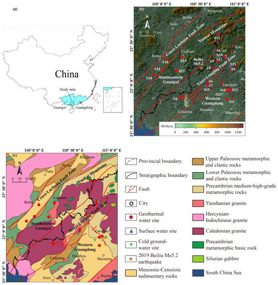
Figure 1.
(a) Location of study area which is located along the border of Guangdong and Guangxi provinces; (b) elevation map of the study area and investigation site locations, data based on ASTER GDEM v3 Worldwide Elevation Data; (c) regional bedrock geological map of the study area (modified from Xu et al., 2019 [23]; Qing et al., 2020 [24]).
Tectonically, the study area is located in the Yunkai Uplift [15]. The XL Fault Zone in Western Guangdong and the CL Fault Zone in Southeastern Guangxi (Figure 1b) are two main fault zones in the region. The two fault zones are characterized by large or deep faults and both go through the whole region and are northeast-trending. Among them, the XL Fault Zone is in the central hinterland of the Yunkai Uplift, while the CL Fault Zone is in the northwest margin of the Yunkai Uplift. The XL Fault Zone is about 150 km long and 5–22 km wide, with a strike of 20–70°. The main body of the XL Fault Zone is composed of two large faults with obvious synclinous bending in the east and west [26]. The CL Fault Zone is the eastern branch of the Hepu–Beiliu Fault Zone, with a strike of 40–60°, a length of more than 300 km, and a width of 10–45 km [7,27,28]. It is formed by the combination of faults with different extension directions in multiple periods, and is likely to be as deep as the Moho surface [27].
The Yunkai Uplift, as the combination of the Cathaysia and the Yangtze Block, has a complex tectonic historical background, and has experienced multiple periods of movements such as the Caledonian, Hercynian–Indosinian, Yanshanian, and Himalayan [20,26,27]. The Yunkai Uplift is notable for its extensive outcrops of ancient rocks, with the Precambrian–Paleozoic metamorphic system as the base and widely distributed clastic rocks and granites in the whole area (Figure 1c). The ancient Precambrian medium–high-grade metamorphic rocks (such as migmatite or mixed gneiss) and Caledonian granites are commonly visible in the central-eastern part of the district. The relatively young Lower and Upper Paleozoic groups are mainly composed of clastic rocks and metamorphic rocks with different degrees of metamorphism. These Paleozoic rocks and the contemporaneous Hercynian–Indochinese granites are distributed in the central-western parts of the region, while the even younger Mesozoic–Cenozoic continental sedimentary rocks are mainly distributed in the low-lying areas, partly distributed in the riverbanks, river valley basins, and the southern coastal plain. And the Mesozoic Yanshanian granites are less exposed [1,15,20,21,23,24,29]. Compared with the XL Fault Zone, the stratigraphy along the CL Fault Zone is relatively young. As seen in Figure 1c, the ancient Precambrian metamorphic rocks and Caledonian granites are common along the XL Fault Zone. Along the CL Fault Zone are mainly Paleozoic metamorphic rocks and clastic rocks, as well as there being several Mesozoic–Cenozoic sedimentary rock basins.
The Yunkai Uplift is rich in geothermal resources, and the geothermal waters are exposed along the XL Fault Zone and CL Fault Zone with large or deep faults as the fast flow channels. The Yunkai Uplift has a high heat flow level (70–100 mW/m2) [5], with publicly released data showing a measured heat flow value of 98.2 mW/m2 in the Xinyi area [4], which is one of the highest values within the Guangdong and Guangxi regions [6]. Upwelling of mantle magma is thought to exist beneath the lower crust in the hinterland of the Yunkai Uplift, which may make a key contribution to the regional high heat flow. Meanwhile the upwelling of mantle magma is also considered to be the trigger for seismic activities in the Yunkai Uplift, such as the 2019 Beiliu Ms5.2 earthquake that occurred in the XL Fault Zone [7,19].
3. Sampling and Methods
3.1. Investigative Activities
Three periods of investigative activities were conducted in the study area. The first sampling event was held in April 2018, collecting 18 geothermal water samples, and 5 non-thermal water samples (including 3 cold groundwaters and 2 surface waters). All the geothermal waters were collected and measured at spring vents or wellheads at the surface. Cold groundwaters were collected from residential wells and surface waters were from rivers or streams. The second sampling event was in August 2022, with re-collections at most of the geothermal sites, with 13 geothermal water samples and 1 surface water sample collected. These two sampling events collected a total number of 31 geothermal water ones, and 6 non-thermal water ones in this study (Figure 1b). And the third investigation was in March 2024: in situ measurements of dissolved CO2 and H2 contents were made for most geothermal waters and non-thermal waters, but no water samples were collected.
In each of the first two sampling campaigns, in situ measurements were made for unstable hydrochemical parameters including temperature (T), pH, and electrical conductivity (EC), with a WTW Multi 3400i multiparameter portable field meter. The field-collected water samples were stored in polyethylene bottles that had been rinsed with onsite water three times before sampling. All the aqueous chemical samples were filtered through 0.45 μm membranes on site. Samples for cations, trace element, and strontium isotopes analyses were acidified with ultrapure HNO3 to a pH less than 2, while no reagents were added to those for anions, δ2H, and δ18O analyses. A saturated HgCl2 solution was added to the δ13CDIC samples to inhibit the effects of microbial activity. In the third investigation campaign, AMT CO2 and H2 sensors were used for in situ measurements of dissolved CO2 and H2 in waters, respectively.
3.2. Sample Testing
For samples collected in April 2018 (the first-time sampling event), the major ions’ (Na+, K+, Ca2+, Mg2+, Cl−, SO42−, NO3−, HCO3−) analyses were completed in the laboratory of the Institute of Groundwater and Earth Sciences, Jinan University, using the ion chromatography instrument (Thermo ICS Aquion). Trace element (F−, Sr, SiO2) analyses were performed in the Experimental Technology Analysis & Test Center of Jinan University, using inductively coupled mass spectrometry (ICP-MS). The δ2H and δ18O stable isotope compositions in water samples were measured by using the stable isotope mass spectrometer (MAT253) at the Institute of Karst Geology, Chinese Academy of Geological Sciences, with the results reported relative to the SMOW standard, and the errors were about ±0.5‰ for δ2H and ±0.05‰ for δ18O measured in the laboratory. The 87Sr/86Sr ratios of geothermal waters were analyzed using the isotope mass spectrometer (MAT-261) at the State Key Laboratory of Geological Process and Mineral Resources in Wuhan, China, University of Geosciences.
For the samples collected in the second event, the major ions F−, Sr, and SiO2 were re-measured. Newly added measurements were made for the δ13C of Dissolved Inorganic Carbon (DIC) analysis (relative to the VPDB standard), and trace elements Li and B. All these tests were performed at the Institute of Karst Geology, Chinese Academy of Geological Sciences.
4. Results
4.1. Physiochemical Parameters and Major Ions
In this study, two events of water sampling were conducted and both were synchronized with in situ measurements of sample physiochemical parameters including temperature, pH, and EC. The physiochemical parameters and major ions data of all water samples are listed in Table 1, and two batches of samples from the same sampling sites are distinguished by the labels -1 and -2. The in situ-measured temperatures of geothermal and non-thermal waters vary from 27.5 °C to 76.8 °C and from 22.3 °C to 28.4 °C, respectively. The temperatures of geothermal waters range from 33.4 °C to 76.8 °C in the XL Fault Zone and from 27.5 °C to 55.6 °C in the CL Fault Zone. The pH values of all samples vary from 6.14 to 9.18. For the geothermal water samples, the average pH values are 8.12 and 6.83 in the XL Fault Zone and CL Fault Zone, respectively. The TDS values of the geothermal waters range from 151.96 mg/L to 1016.00 mg/L, while non-thermal waters have a TDS in the range of 41.40 mg/L–110.18 mg/L. The average TDS values are 382.71 mg/L in the XL Fault Zone and 329.78 mg/L in the CL Fault Zone, showing a slight difference.

Table 1.
Physicochemical parameters and major ion concentrations of water samples (temperature in °C, EC in μS/cm, TDS in mg/L, and concentration in mg/L).
The water samples were plotted on a Piper diagram (Figure 2) and on a histogram (Figure 3). For geothermal waters in the XL Fault Zone, the cations are dominated by Na+, while Ca2+ has a higher percentage in CL geothermal waters and non-thermal waters. The dominant anion in most water samples is HCO3−, followed by SO42−. The Piper diagram shows that the XL geothermal waters have relatively similar water types, dominated by HCO3SO4-Na and HCO3-Na types. The water types of CL geothermal waters show vast variations. The nine geothermal waters from five sample sites in the CL Fault Zone have seven types including SO4HCO3-Ca, SO4-Ca, HCO3SO4-Na, HCO3-Ca, HCO3-Na, HCO3SO4-NaCa, and HCO3-CaMg types, while the non-thermal waters are also type varied.
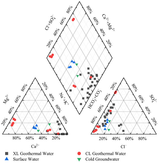
Figure 2.
Piper diagram for water samples from XL Fault Zone and CL Fault Zone.
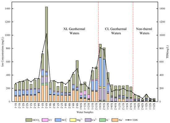
Figure 3.
Concentration histogram of major ions in water samples.
4.2. Trace Elements
The geothermal water samples from the XL Fault Zone have F− contents that are much more enriched than those from the CL Fault Zone and non-thermal waters (Table 2). The F− concentrations are 1.79 mg/L–19.78 mg/L in the XL Fault Zone, 0.07 mg/L–6.99 mg/L in the CL Fault Zone, and 0.07 mg/L–0.35 mg/L in non-thermal waters. Most of the geothermal waters have F− concentrations higher than 1.00 mg/L, and are considered as high-fluoride waters [30].
Table 2.
Trace element concentrations in the water samples (in mg/L).
Other trace elements in geothermal waters were also tested, including Sr, Li, and B, but none of them have high concentrations. The Sr concentrations range from 0.04 mg/L to 1.64 mg/L; Li from 0.01 mg/L to 0.60 mg/L; and B from 0.01 mg/L to 0.79 mg/L. The Li and B concentration values are far lower than those in high-temperature geothermal systems affected by magmas like the Yangbajing geothermal field in Tibet, China (7.5 mg/L–20.9 mg/L for Li and 45.9 mg/L–96.7 mg/L for B) [9,31,32].
4.3. Isotope Compositions
The isotope composition data for the water samples include δ2H and δ18O, the 87Sr/86Sr ratio, and δ13C (Table 3 and Table 4). These isotope data are the critical tracers of the origin of water sample components, providing important references about the formation and evolution processes of geothermal waters.
Table 3.
δ2H-δ18O isotopic compositions. Based on the δ2H-δ18O values, the d-values and recharge elevations were calculated.
Table 4.
87Sr/86Sr ratios and δ13C values of geothermal water samples.
The sampled geothermal waters have δ18O ranging from −7.71‰ to −5.91‰ with an average 6.71‰, and δ2H from −50.9‰ to −37.9‰ with an average of −43.9‰. The non-thermal waters have more positive δ18O and δ2H values, ranging from −5.45‰ to −5.02‰ (medium −5.23‰) and from −35.4‰ to −31.1‰ (medium −33.3‰), respectively.
For the Sr isotope, the 87Sr/86Sr ratios of the geothermal waters in the XL Fault Zone are between 0.7140 and 0.7392, with an average value of 0.7266. The average 87Sr/86Sr ratio of the geothermal waters in the CL Fault Zone is 0.7273, and the values range from 0.7209 to 0.7385.
The δ13CDIC value is a useful tool for indicating the sources of DIC in waters. The δ13CDIC values determined in the geothermal waters from the XL Fault Zone and CL Fault Zone range from −13.54‰ to −2.02‰ and from −13.11‰ to −8.56‰, respectively. S5-2 from Baoxu has the most positive δ13CDIC value (−2.02‰), followed by S13-2 from Licun (−6.02‰) and S9-2 from (−6.57‰). Otherwise, the water sample from Xijiang River (S20-2) has the most negative δ13CDIC value of −14.09‰.
4.4. Dissolved CO2 and H2 Concentrations in Waters
Following the two sampling events, the third investigation event was supplemented with in situ measurements of dissolved CO2 and H2 concentrations in geothermal and non-thermal waters, the results of which are shown in Table 5. For the dissolved CO2 concentrations in geothermal waters, the highest concentration is 537.10 mg/L in Baoxu (S5), followed by 138.73 mg/L in Hehua (S9), and those in other geothermal waters range from 0.93 mg/L to 34.44 mg/L, with no obvious excess. And in non-thermal water, the concentrations ranged from 1.69 mg/L to 2.93 mg/L. H2 concentrations are extremely low in both geothermal and non-thermal waters, ranging from 0.004 mg/L to 0.019 mg/L in geothermal waters and 0.005 mg/L to 0.009 mg/L in non-thermal waters, respectively.
Table 5.
Dissolved CO2 and H2 concentrations in geothermal and non-thermal waters (in mg/L).
5. Discussions
5.1. Granite-Dominated Water–Rock Interaction Processes
The Piper diagram (Figure 2) based on the main ions shows that the geothermal waters from the XL Fault Zone are similarly distributed in the diagram, suggesting that the environments and processes in which they formed and evolved may have been very similar. Non-thermal waters are distinguished from geothermal waters in the diagram. And the closer the geothermal waters are to the non-thermal waters, the more they are affected by the non-thermal waters. CL geothermal waters also show differences from XL geothermal waters. A few CL geothermal waters are similar to XL geothermal waters but closer to non-thermal waters. A portion of the CL geothermal waters are distinctly different from the XL geothermal waters, exhibiting abundant SO42− and Ca2+ contents, which is indicative of possible differences in the geothermal environments of the two fault zones.
The sources of major ions in the water samples can be preliminarily determined by Gibbs diagram (Figure 4), which was proposed by Gibbs (1970) [33] for classifying cations and anions. Figure 4a shows that the major ions in geothermal waters came from the water–rock interactions, while the non-geothermal waters were affected more by atmospheric precipitation. Compared to Figure 4a, most of the geothermal waters in Figure 4b are panned to the right, which may reflect the relative excess of Na+ in the geothermal water.
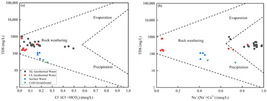
Figure 4.
Anion (a) and cation (b) Gibbs graphs. Different parts of the area bounded by the dotted lines indicate that the water sample may be affected by precipitation, evaporation, or water-rock interaction (rock weathering) processes, respectively.
The ionic relationships illustrated in Figure 5 allow for further discussion of the water–rock interaction processes of the geothermal waters. As shown in Figure 5a, the far excess of Na+ relative to Cl− in most of the geothermal waters is a result of the dissolution of the abundant Na+-bearing silicate minerals in granites [34,35]. In conjunction with Figure 5b–d, the excess of HCO3− and SO42− ions relative to Ca2+ and Mg2+ in many geothermal waters also implies the occurrence of an ion-exchange effect, which is a common occurrence in Na+-rich geothermal water systems. For the exchange of Ca2+ and Mg2+ in geothermal waters with Na+ in surrounding Na+-bearing silicate minerals, resulting in the relative deficiency of Ca2+ and Mg2+, the process is as follows:
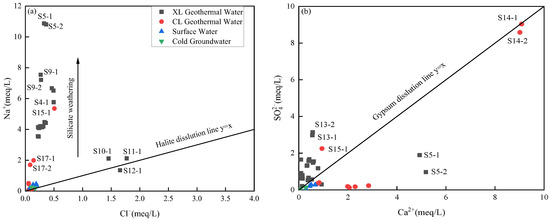
Figure 5.
Distributions of ionic ratios, including (a) Na+ versus Cl−, (b) SO42− versus Ca2+, (c) 0.5HCO3− versus (Ca2+ + Mg2+), and (d) (HCO3− + SO42−) versus (Ca2+ + Mg2+), in water samples.
The HCO3− and SO42− in geothermal waters may originate from the dissolution of carbonate minerals (e.g., calcite and dolomite) and sulfate minerals (e.g., gypsum). Additionally, the conversion of additional CO2 and sulfide or SO2 should not be ignored. Although most of the geothermal waters are controlled by silicate minerals, there are still some geothermal waters that lie on or close to the dissolution line of carbonate minerals or sulfate minerals in Figure 5, showing the contribution to the HCO3− and SO42− contents from these minerals. In this study, S5-2 from Boxu (S5) and S9-2 from Hehua (S9) have high HCO3− concentrations, especially S5-2, which essentially meet the definition of carbonated water and may have potential deep-derived CO2 replenishment. Meanwhile, the odor of H2S is usually noticeable at the sampling sites of some geothermal waters, implying that some geothermal waters may contain relatively high amounts of S2−, which can be further converted to SO42− in an oxidizing environment near the surface.
In this study, most of the geothermal waters are F−-rich, mainly due to the dissolution of fluorite, which is also a relatively more abundant mineral in granites [36]. As shown in Figure 6, there are certain negative correlations between (Ca2+ + Mg2+) concentrations and F− concentrations (Figure 6a), and a positive correlation between pH values and F− concentrations (Figure 6b) in the geothermal waters. With the increase in (Ca2+ + Mg2+) concentrations, F− concentrations decrease. This is because Ca2+ and Mg2+ easily react with F−, resulting in insoluble CaF2 and MgF2 precipitation, and resulting in the deficiency in F− [36]. On the other hand, the Na-type waters herein are conducive to the enrichment of F−, because the exchange of Ca2+ and Mg2+ with Na+ has reduced the Ca2+ and Mg2+ concentrations. There is also a similar exchange reaction between F− and OH−. This is because F− and OH− have the same charge number, and similar molecular weight and ionic radius, resulting in similar physical and chemical properties. In an alkaline water environment, free OH− can replace F− adsorbed on the surface of surrounding rock minerals, and thus, this increases the concentrations of F− in the waters [37].

Figure 6.
(a) F− versus (Ca2+ + Mg2+) and (b) F− versus pH diagrams.
Based on the analysis, most of the geothermal waters in the study area exhibit water–rock interaction processes primarily controlled by granites, which are rich in silicate and fluorite minerals. However, within the CL Fault Zone, several geothermal waters, such as those from Wenluo (S14), Jiatang (S16), and Hetanglie (S18), are instead dominated by carbonate or sulfate minerals, with extremely low F− concentrations. This suggests that geothermal waters from the CL Fault Zone, particularly those in Bobai County, experienced less influence from granites than those in the XL Fault Zone. Moving westward from the XL Fault Zone, the dominant lithologies change from granites to metamorphic and sedimentary rocks, which contain higher amounts of carbonate and sulfate minerals. In contrast, along the CL Fault Zone, granites are less prevalent.
5.2. 87Sr/86Sr Ratios
Strontium isotopes are also an important tool in indicating the role of water–rock interaction. The 87Sr/86Sr ratios in geothermal waters should theoretically be similar to those of the surrounding rocks. Different surrounding rock conditions have different 87Sr/86Sr ratios, e.g., 0.7068–0.7094 for carbonate rocks and 0.7030–0.7050 for basalts [38,39]. Whereas values of granites are generally higher and have a wide range around the world, for example, even within the Yunkai area, there is a clear difference between the 87Sr/86Sr ratios in the ancient Caledonian granites (mean 0.7309) and the Mesozoic Yanshanian Baoxu granite (mean 0.7120) [21,22].
The 87Sr/86Sr ratios of geothermal waters are plotted in Figure 7. For better discussions, the plot has additional information about the 87Sr/86Sr ratios for rocks in the Yunkai Uplift or Guangdong area in the referenced studies [21,40,41,42,43]. The average 87Sr/86Sr ratio of Caledonian granites in the Yunkai Uplift (0.7309) is higher compared to the rest of Guangdong (0.7090–0.7223), which is one of the differences between the widely distributed ancient Caledonian granites in Yunkai and the prevalent younger Mesozoic Yanshanian granites in the rest of Guangdong. Meanwhile, high values were also measured in metamorphic and sedimentary rocks (0.7529 and 0.7242, respectively) within and around the Yunkai [21,41]. The 87Sr/86Sr ratios for the geothermal waters coincide well with their surrounding rock conditions and can be interpreted by dividing them into three groups:

Figure 7.
Diagram of 87Sr/86Sr-Sr for geothermal water samples. Reference data: (1) paragneissic, Yunkai, 0.7529 [21]; (2) Caledonian granites, Yunkai, 0.7309 [21]; (3) sandstones, Western Guangdong, 0.7242 [41]; (4) granites, Guidong, 0.7223 [40]; (5) granodiorites, Enping, 0.7142 [22]; (6) granites, Jiufeng, 0.7136 [40]; (7) granites, Baoxu, 0.7120 [22]; (8) granites, Fogang, 0.7096 [43]; (9) granites, Fengshun, 0.7090 [42]; (10) carbonate rocks, 0.7081 [39]; (11) basalts, 0.7040 [39].
Group 1 includes samples from the sites of S1, S2, S3, S5, S9, and S14 with 87Sr/86Sr ratios above 0.7350. Among them, S1, S2, S3, S5, and S9 samples from the XL Fault Zone represent the surrounding rock conditions of the oldest metamorphic rocks and Caledonian granites in the study area. On the side of the CL Fault Zone, the surrounding rocks at S14 have a high degree of fracture weathering, which increases the Sr concentration and also enhances the 87Sr/86Sr ratio level.
Group 3 includes samples from the sites S6, S7, S8, S10, and S11, with the 87Sr/86Sr ratios less than 0.7200, which represent the younger part of the surrounding rocks in the study area. Geothermal waters from S6, S7, and S8 are exposed from the Mesozoic Yanshanian Baoxu granite, while samples from S10 and S11 are located in the southward relatively coastal part, where the young sedimentary rocks are found.
Group 2 is between Groups 1 and 3, and includes samples from the sites S4, S12, S13, S15, S16, S17, and S18, with the 87Sr/86Sr ratios ranging from 0.7350 to 0.7200, which is presumed to be due to a combined effect of the young and old surrounding rocks. As in Zhenlong (S4), the contact between the Caledonian and Yanshanian granites can be seen; the geothermal waters from Luchuan (S15) and Xielu (S17) are controlled by the Yanshanian granites but may also be influenced by Ordovician metamorphic rocks at the same time.
5.3. δ2H-δ18O Relationship and Water Recharge Characteristics
As shown in Figure 8, all the water samples have δ2H-δ18O values plotted close to the Global Meteoric Water Line (GMWL) [44] and Local Meteoric Water Line (LMWL) [45], suggesting their direct derivation from atmospheric precipitation. Long periods of water–rock interactions at high temperature may lead to the exchange of oxygen isotopes between geothermal waters and surrounding rocks, and will often show a positive δ18O-shift that deviates from the meteoric water line in the δ2H-δ18O diagram [10,45,46,47]. However, there is no sign of the “oxygen shift” in this study, indicating that the oxygen isotope exchange is relatively weak.
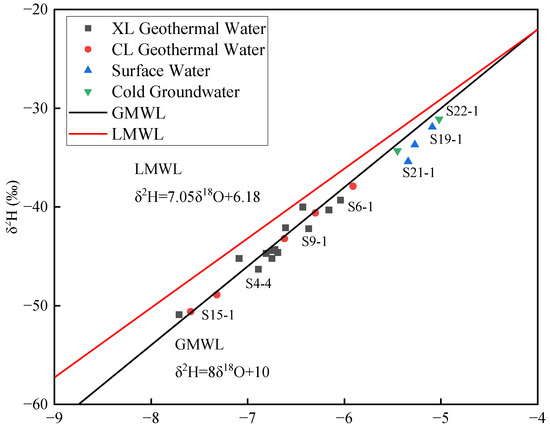
Figure 8.
δ2H versus δ18O diagram for the water samples with Global Meteoric Water Line (GMWL) and Local Meteoric Water Line (LMWL).
The deuterium excess parameter (d) can be used to evaluate the renewal ability of geothermal water and the supply source [45]. Through the formula proposed by Dansgaard, 1964 [48] (), the d values of the geothermal waters were calculated, and obtained results between 8.76‰ and 11.44‰ (mean 9.23‰) (Table 3). The average d value of the geothermal waters is close to that of the non-thermal waters (8.59‰), indicating that geothermal waters in the study area have a relatively strong renewal ability and experienced relatively weak water–rock interactions.
The recharge elevation of groundwater can be calculated by using the altitude effect of stable isotopes [10,49]:
where H and Hg (m.a.s.l.) are the altitude of groundwater recharge area and sampling sites, respectively; Dg and Dr are the δ2H values of groundwater samples and recharge water near the sampling sites (‰), respectively; and gradD is the altitude–δ2H gradient in the study area (‰/m). Herein, the average δ2H value for non-thermal water samples (−33.3‰) and −2‰/100 m [10] are used for Dr and gradD, respectively. The calculated recharge elevations of geothermal waters in the study area range from 304 m to 956 m, with an average recharge elevation of 604 m. According to the surrounding topography, the groundwater should be recharged from the Yunkai Mountains in the north of the study area.
5.4. Mixing Characterization and Geothermal Reservoir Temperatures
5.4.1. Cold Water Mixing Ratios
All the water samples are plotted on the Na-K-Mg ternary diagram (Figure 9), showing that all the geothermal waters are in the partially equilibrated and immature areas. This phenomenon implies that all geothermal waters are not in equilibrium and are subject to mixing by shallow cold groundwaters. In comparison with those from the XL Fault Zone, the geothermal waters from the CL Fault Zone have lower degrees of maturity, which may indicate a greater extent of mixing with cold waters.

Figure 9.
Na–K–Mg ternary diagram.
Furthermore, the silica–enthalpy [50] mixing model is used to discuss mixing ratios. In the mixing analyses, relevant thermal dynamic data are obtained from the field-measured data. All the geothermal water samples are plotted in the silica–enthalpy mixing model, with their field-measured temperatures of all samples being converted into the enthalpy values. And the average silica concentration (17.14 mg/L) and enthalpy value (102.02 kJ/kg, 24.4 °C) of non-thermal waters are taken as the cold water end element. The silica–enthalpy mixing model reveals that the initial geothermal waters have the enthalpy value range from about 320 kJ/kg to 747 kJ/kg (Figure 10 and Table 6), and the following formula can be used to calculate the cold water mixing ratios [51]:
where Xc is the ratio of cold water mixing, and Ht, Hi, and Hc represent the enthalpies of geothermal water samples, initial geothermal waters, and cold water, respectively. The calculation shows that the geothermal waters in the study area are affected by the mixing of cold waters to a large extent, with the mixing ratios of 54% to 92% in the XL Fault Zone, and 73% to 83% in the CL Fault Zone (Table 6).

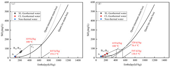
Figure 10.
Silica–enthalpy model for water samples: (a) S1-1, S1-2, S2-1, S3-1, S7-1, S7-2, S8-2; (b) S2-2, S3-2, S6-1, S8-1, S9-1, S10-1, S13-1, S13-2; (c) S4-1, S5-2, S6-2, S9-2, S18-2; (d) S5-1, S14-2, S16-2, S17-2. The field measured temperatures of all water samples are converted into the enthalpy values. Point A is the cold water end element, with the silica concentration of 17.14 mg/L and enthalpy value of 102.02 kJ/kg, 24.4 °C (average value of non-thermal waters). Point B represents the geothermal waters. The line segment AB is extended and intersects the vertical line representing boiling (419 kJ/kg, 100 °C) at point C. The enthalpy value (as well as temperature) of the initial geothermal water can be obtained when the parallel line starting at point C intersects the quartz liquid curve (maximum steam loss).
Table 6.
Estimated results of cold water mixing ratios, geothermal reservoir temperatures, and circulation depths (SiO2 concentration in mg/L, enthalpy values in kJ/kg, temperature in °C, and depth in m).
5.4.2. Geothermal Reservoir Temperatures and Circulation Depths
For estimations of geothermal reservoir temperatures, typical geothermometers, including cationic geothermometers and silica geothermometers, have been widely used in many studies as important tools for geothermal temperature calculation [52,53,54,55]. These methods rely on concentrations of Na+, K+, Ca2+, Mg2+, SiO2, etc., in geothermal water samples to carry out the calculations, and are usually well applied in high-temperature geothermal systems. However, for geothermal systems affected by cold water mixing, the cationic and silica geothermometers may give distorted results due to the changes in the concentrations of substances and the state of chemical equilibrium, and therefore, they will not be discussed in this study.
The silicon–enthalpy mixing model used in the discussion of the effect of cold water mixing in the previous Section 5.4.1 not only provides the results for the cold water mixing ratios, it is also an effective tool for assessing geothermal reservoir temperatures, for enthalpy values of the initial geothermal waters before mixing can be derived through this model, indicating the highest temperatures of the geothermal reservoirs [56]. The results are shown in Figure 10 and Table 6, and the enthalpy results were transformed to give the estimated temperature range from 130.5 °C to 178.5 °C in the XL Fault Zone and from 76.4 °C to 130.5 °C in the CL Fault Zone. With the estimated temperatures, the circulation depths of geothermal waters can be estimated roughly through the following formula:
where D is the maximum depth of geothermal water circulation (m); T0 is the local annual temperature (°C); G is the geothermal gradient (°C/100 m); T is the estimated reservoir temperature (°C); and Z0 is the depth of annual constant temperature. Referring to the previous studies [9], 3.04 °C/100 m, 22.0 °C, and 13 m for G, T0, and Z0, respectively, are used in this study. The calculated circulation depths range from 3730 to 5160 m in the XL Fault Zone and range from 1802 to 3582 m in the CL Fault Zone (Table 6). On the whole, the circulation depths of the XL Fault Zone geothermal waters are deeper than those of the CL Fault Zone.
5.5. Correlation of Rock Metamorphosis with Geologic CO2 and H2 Generations
The δ13CDIC-DIC diagram is shown in Figure 11 for our study area. The HCO3− concentrations of the water samples are converted to the DIC molar concentrations, and with the δ13CDIC values, following the data processing and analysis by Frondini et al. (2009) [57]. The DIC sources include dissolutions of carbonate minerals, and the DIC in waters can also come from CO2 in the atmosphere, soil, and deep strata [58].
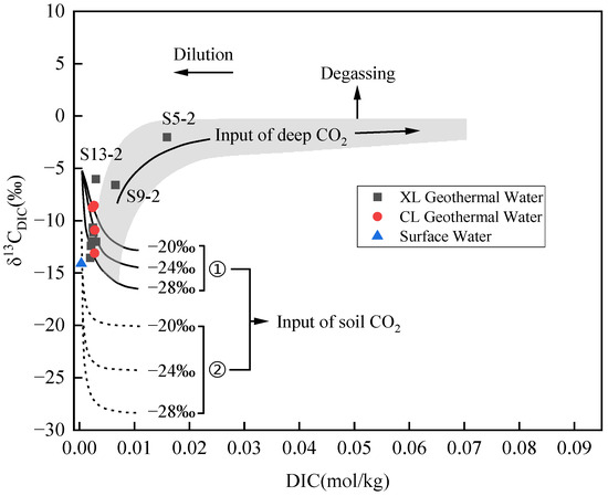
Figure 11.
δ13CDIC versus DIC diagram, modified from Frondini et al., 2009 [57]. ① represents the dissolution of soil CO2 and equilibrium with calcite; ② represents the dissolution of soil CO2 deriving from oxidation of organic matter and root respiration. The shadow region represents the effect of deep-derived CO2.
Dissolved CO2 contents in geothermal waters measured in the study area ranged from 0.93 to 537.10 mg/L. Most of the geothermal sites do not have a significant excess of dissolved CO2 except for Baoxu (S5) and Hehua (S9). Correspondingly, the geothermal waters from Baoxu and Hehua also have the highest concentrations of HCO3−. As shown in the diagram (Figure 11), most of the geothermal water samples are plotted close to the theoretical curves which indicate the dissolution of soil CO2 and equilibrium with calcite, while the water from Xijiang River is on the curves representing the dissolution of soil CO2 deriving from oxidation of organic matter and root respiration. The S5-2 sample from Baoxu and S9-2 sample from Hehua are plotted in the deep CO2-dominated region, and the S13-2 sample from Licun has a relatively positive δ13CDIC value, which can also mean the effect of deep CO2. For a better understanding of the CO2 sources, the δ13CDIC values of water samples are converted to δ13 values according to the following formula [59]:
where a, b, and c are the molarities of H2CO3, HCO3−, and CO32−, respectively; εa-g, εb-g, and εc-g are the fractionation factors between the C species, which can be calculated from the following equations [60]:
where T is the thermodynamic temperature in K.
The results show that the δ13CCO2 values of the water samples in the region range from −20.37‰ to −3.99‰ (Table 4). Whereas the organic δ13CCO2 values range from −22.0‰ to −10.0‰ [61], deep-derived CO2 commonly has values ranging from −8.0‰ to +3.0‰, including −8.0‰ to −3.0‰ for mantle-derived CO2, and −3.0‰ to +3.0‰ for metamorphic CO2 from crustal carbonate rocks [38,62,63,64].
The δ13CCO2 values of most water samples were in the range of organic genesis, controlled by soil CO2. With the value of −3.99‰, the Baoxu geothermal water (S5-2) is clearly controlled by deep-derived CO2. It lies within the range of mantle-derived CO2 and is close to that of metamorphic CO2. However, the depth at which the XL Fault Zone cuts into the Earth’s crust is less understood, and previous studies have commonly categorized it as a large fault zone rather than a deep fault zone [41,65]. Here, we prefer metamorphic CO2 to explain the CO2 in Baoxu, which may be associated with the Mesozoic Baoxu granite exposed a short distance to its south. Although the Baoxu geothermal water appeared in the Precambrian metamorphic rocks rather than the Baoxu granite outcrop, it can be hypothesized that the Baoxu granite may have intruded into the lower part of the Baoxu geothermal site. The contact between the high-temperature granite magma and the carbonate minerals in the metamorphic layer triggered the metamorphic degassing, which is the main reason for the generation of the metamorphic CO2. From the analysis of 87Sr/86Sr ratios, the geothermal water in Baoxu is not affected by the younger Mesozoic granites, which means that the location of the granite intrusion is further down the Baoxu geothermal water circulation path. The metamorphic CO2 generated is transported upward through the fault and converges with the geothermal water to form the unusual Baoxu geothermal water. Some geothermal waters with relatively positive δ13CCO2 values, including those from Licun, Hehua, and Xielu, may also have been influenced by metamorphic CO2, for contact between granite and metamorphic rocks or sedimentary rocks may exist in these sites.
The extremely low concentrations of dissolved H2 (Table 5) in the geothermal waters of the study area are, on the one hand, related to the low solubility of H2 in the water and, on the other hand, closely related to the geological conditions of the study area [66]. Calculations of thermal storage temperatures, combined with the low H2 contents, rule out the existence of a high-temperature geothermal system in the study area [67]. The lithologic conditions in the study area are not conducive to H2 generation. The currently recognized predominant mode of geological H2 generation is the serpentinization reaction between water and Fe-rich peridotite under high-temperature and high-pressure conditions [67,68]. Although the Xinyi area in the region is the production area of serpentinized jade, it is mainly derived from the metamorphism of Mg-rich peridotite [69] and lacks the presence of Fe-rich peridotite in the study area. In addition, the lack of a thick sedimentary rock cover in the study area is not conducive to H2 storage [66].
5.6. 3He/4He Ratios and Heat Flow Discussions
The interpretation of CO2 in Baoxu geothermal water as metamorphic process-dominant rather than mantle derived in Section 5.5 can be further verified by the 3He/4He ratio. Different sources of helium have significantly different 3He/4He ratios, with atmospheric, crustal, and mantle helium characterized by 3He/4He ratios of 1.4 × 10⁻⁶, ~10−8, and ~10−5, respectively [70,71]. And it is often expressed as the ratio of the 3He/4He ratio of a sample (R) to the atmospheric 3He/4He ratio (Ra, usually 1.4 × 10⁻⁶), i.e., R/Ra. In general, helium dominated by a crustal source has an R/Ra < 1. And with the increasing mantle source contribution, the value will increase and be greater than 1 [72].
The R/Ra value of escaped gas from the Baoxu geothermal site investigated by Zhao et al. (2021) [19] is 0.826 (Table 7), suggesting a clear crustal genesis of the helium at this site and rather small mantle contribution. The R/Ra values of geothermal sites including Xijiang, Zhenlong, and Xinshidai in the XL Fault Zone are even smaller, indicating an even more sparse mantle contribution, whereas in the CL Fault Zone, the highest R/Ra value of 1.609 in the study area was measured in Jiatang. This indicates that the CL Fault Zone, as a component of the western boundary of the Yunkai Uplift, is more likely to have penetrated deeper into the Earth’s crust and touches the upper mantle, and served as a conduit for mantle-derived materials, than the XL Fault Zone in the central part.
Table 7.
R/Ra values in the study area and U, Th, K concentrations and calculated heat generation value A of Caledonian granite in the Xijiang Geothermal Field in Xinyi.
However, the CL Fault Zone, which may cut deeper into the crust, could have failed to provide a deeper circulation path for the geothermal waters. The number of sites, exposed temperatures, calculated geothermal reservoir temperatures, and circulation depths of the geothermal waters in the CL Fault Zone are overall smaller than those in the XL Fault Zone, showing a relatively weaker hydrothermal activity level. This may first imply that there is not only a difference in the depth between these two fault zones, but also a difference in the degree of opening and permeability, whereas the XL Fault Zone may be more affected by tension than the CL Fault Zone.
The deep part of the Yunkai Uplift is thought to be characterized by the upwelling of mantle magma. It can be hypothesized that this mantle magma upwelling phenomenon may be more pronounced beneath the deep crust of the hinterland of the Yunkai Uplift, i.e., the XL Fault Zone and its surrounding areas. The upwelling mantle magma may be so powerful that the XL Fault Zone is subjected to a certain degree of tension, which is more favorable to the deep circulations of geothermal waters. Within the XL Fault Zone, upwelling magma is also thought to have triggered the 2019 Beiliu Ms5.2 earthquake, which would lead to the creation of additional fractures within the crust [7,19].
In addition, there is no doubt that the upwelling mantle magma contributes significantly to the high heat flow in the Yunkai Uplift. The regional heat flow usually consists of mantle and crustal heat flow. In the crustal heat flow, the radiative heat of rocks originating from the upper crust is the most important component, and the heat production capacity of granites is the most outstanding [13]. Taking the example of Xijiang geothermal field’s Caledonian granite [73] in Xinyi, the heat generation rate can be estimated according to Equation (7) [74].
in which A (μW/m3) is the heat generation value of radioactive elements, ρ (g/cm3) is the rock density, CU (ppm), and CTh (ppm), and CK (wt.%) refers to U, Th, and K concentrations in rock, respectively; the values are listed in Table 7.
The heat generation rate of the Caledonian granite in the Xinyi Xijiang geothermal field was calculated to be 5.30 μW/m3, which is only slightly less than that of the Yanshanian granite in the Fengshun geothermal field in eastern Guangdong (5.87 μW/m3) [5]. The Xinyi and Fengshun areas have similar granite heat generation rates and crustal thicknesses of 29.6 and 29.8 km [75], respectively. It can be reasonable to assume that the values of crustal heat flow in the two areas are similar, with a crustal heat flow value about 40.0 mW/m2 in Xinyi, while Li et al. (2023) [5] obtained the value of 43.1 mW/m2 in Fengshun. Thus, compared to the 72.2 mW/m2 heat flow in Fengshun, the 98.2 mW/m2 heat flow in the Xinyi area has a much larger portion of mantle-source contribution, corresponding to the upwelling mantle magma. At the same time, the difference in heat flow distribution caused by the different degree of mantle magma upwelling and high heat-generating granite enrichment, should also be an important reason why the central hinterland of the Yunkai Uplift (XL Fault Zone) has more abundant geothermal water resources compared to the fringe zone (CL Fault Zone).
5.7. Hydrogeological Conceptual Model of the Geothermal System
Based on the hydrochemical and isotopic characteristics of the waters, and the geological background of the Yunkai Uplift, a hydrogeological conceptual model is proposed for the geothermal water system in the study area (Figure 12).
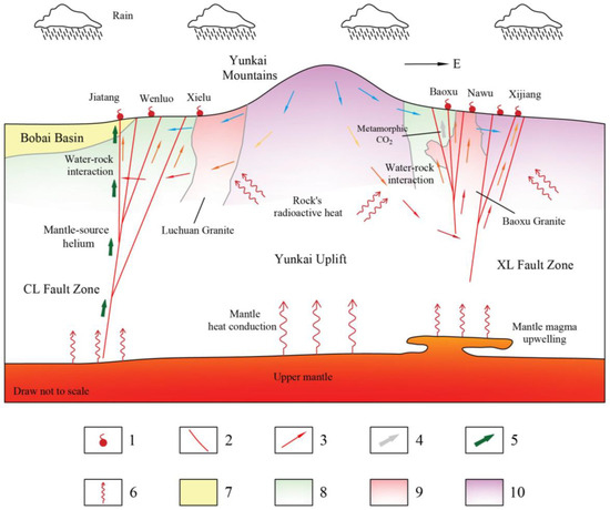
Figure 12.
Hydrogeological conceptual model of geothermal system in study area. 1—Geothermal water; 2—fault; 3—groundwater flow, different colors represent groundwater flow at different temperature levels, with increasing trend from blue to orange to red; 4—metamorphic CO2; 5—mantle-source helium; 6—heat flow; 7—sedimentary rocks; 8—metamorphic rocks; 9—Yanshanian granites; 10—Caledonian granites.
The low concentrations of Li and B in the geothermal waters (Table 2, Section 4.2) rule out the possibility of direct heating by crustal residual magma in this region [9,31,32]. The heat source in the Yunkai Uplift is still the typical combination of radiative heat from crustal rocks and conductive heat from the mantle. The granites widely distributed in the Yunkai Uplift have good radiative heat generation capacity, and the upwelling of mantle magma beneath the regional crust further contributes a large amount of heat flow, which makes the Yunkai Uplift have higher heat flow values than most of the areas in Guangdong.
The results of the δ2H-δ18O analyses (Section 5.3) show that the geothermal waters in the study area come from atmospheric precipitation, and that the average recharge elevation is 604 m, which is consistent with the Yunkai Mountains in the north of the study area. After infiltrating to certain depths, the meteoric waters are heated to 76.4 °C–178.5 °C by the heat sources, then migrate along the XL Fault Zone and CL Fault Zone under buoyant force, with 54–92% cold groundwater mixings in shallow strata, and finally emerge on the surface. During the formation and migration of geothermal waters, the water–rock interactions between waters and surrounding rocks with different lithologies dominate the types and contents of substances in geothermal waters. However, in general, the water–rock interactions of geothermal waters in this study are not strong. Overall, the water–rock interactions of most geothermal waters in the study area are dominated by widely distributed granites, and there is also influence of mixed contacts of rocks of different types and ages. Contacts between Yanshanian intrusion granites and metamorphic rocks triggered metamorphic CO2 generation, creating distinctive carbonated geothermal water (Baoxu) at individual geothermal sites.
Unlike the XL Fault Zone, which is dotted with granites, especially Caledonian granites, the CL Fault Zone is more commonly characterized by metamorphic and sedimentary rocks. Meanwhile, as a boundary component of the Yunkai Uplift, the CL Fault Zone may have a deeper depth than the XL Fault Zone and can reach deeper into the crust and even the upper mantle, forming an upward pathway for mantle-source helium and outcropping of it at a geothermal site. However, it seems that in the hinterland of the Yunkai Uplift, the XL Fault Zone may have been affected by more significant effects of upwelling mantle magma. With richer granite heat generation, and more pronounced thermal and mechanical effects from mantle magma upwelling, the XL Fault Zone has a higher heat flow and is more conducive to deeper circulation of geothermal waters, leading to more active hydrothermal activities than the CL Fault Zone.
6. Conclusions
This study investigated the geothermal system in the Yunkai Uplift. A total of 31 geothermal water samples and 6 non-thermal water samples were collected along the Xinyi–Lianjiang (XL) Fault Zone and the Cenxi–Luchuan (CL) Fault Zone. The water samples were measured and analyzed for the major ions, trace elements, isotope characteristics (H, O, Sr, C, He), and dissolved gas fluxes (CO2 and H2). Additionally, geothermal reservoir temperatures, circulation depths, and mixing ratios were estimated. Based on these findings, a hydrological conceptual model of the geothermal system was proposed. The study’s conclusions can be summarized as follows:
(1) The geothermal waters in the XL Fault Zone are primarily of HCO3-SO4-Na and HCO3-Na types (Table 1). In contrast, the CL Fault Zone contains multiple water types, with relatively higher proportions of Ca2+. Additionally, non-thermal waters are predominately of HCO3-NaCa type.
(2) Water–rock interactions play a key role in controlling the compositions and concentrations of the geothermal waters (Figure 4). However, these interactions are not particularly strong. For most geothermal waters, granites which are rich in silicate minerals dominate the water–rock interactions. Meanwhile, ion exchange is a significant process that leads to the excess of SO42− and HCO3− relative to Ca2+ and Mg2+ (Figure 5).
(3) The lithological distribution of the Yunkai Rise hinterland is dominated by granites, with Caledonian granites being particularly widespread. Moving from the XL Fault Zone in the hinterland to the CL Fault Zone at the western boundary, the dominant lithologies transition from granites to metamorphic and sedimentary rocks. The 87Sr/86Sr ratios of the geothermal waters vary widely (Figure 7, Table 4), indicating a complex interaction between rocks of different lithologies and ages within the study area. This interplay collectively influences the evolutions of the geothermal waters.
(4) Geothermal waters in the study area originate from an atmospheric source and are recharged from the Yunkai Mountains in the north, as indicated by δ2H-δ18O analyses (Figure 8, Table 4). Meteoric waters migrate along the XL and CL Fault Zones, undergoing mixing with 54–92% cold groundwater in the shallow strata (Table 6). As groundwaters circulate to depths of approximately 1802 m–5161 m, they are heated to temperatures ranging from 76.4 °C to 178.5 °C. Under buoyant force, the heated waters ascend and ultimately emerge at the surface.
(5) The calculated δ13CCO2 values (Table 4) indicate the presence of metamorphic CO2, while the primary sources of CO2 in most geothermal waters are predominantly of organic origin. At specific sites, the contact between intruded granite and ancient metamorphic rock has facilitated the formation of metamorphic CO2, which then interacts with geothermal water at Baoxu, producing an unusual carbonated geothermal water. However, the absence of Fe-rich peridotite and thick sedimentary cover in the study area limits the generation and storage of H2 from serpentinization metamorphism.
(6) The CL Fault Zone may extend deeper into the crust or even reach the upper mantle, as suggested by the presence of mantle-source helium (Table 7). In contrast, hydrothermal activities in the XL Fault Zone are more intense. This is because the XL Fault Zone is more enriched with highly heat-generating granites and is more directly affected by the thermal and mechanical effects exerted by mantle magma, resulting in a higher heat flow and some tension influence. Additionally, mantle magma upwelling supplies abundant mantle heat flow to the Yunkai area, which is the primary driver of its exceptionally high heat flow.
Author Contributions
Formal analysis, X.H., Y.Z., S.L., H.O. and B.W.; Investigation, X.H., Y.Z., S.L., G.L., H.O. and B.W.; Data curation, X.H. and Y.Z.; Writing—original draft, X.H.; Writing—review & editing, X.H. and G.L.; Supervision, G.L.; Project administration, G.L.; Funding acquisition, G.L. All authors have read and agreed to the published version of the manuscript.
Funding
This research was funded by the National Natural Science Foundation of China (Grant number 41572241).
Data Availability Statement
The data presented in this study are openly available in [Mendeley Data] at [10.17632/p5xjtzv5ks.1].
Acknowledgments
We express thanks for the help from the authority of Xinyi Seismic Station and Guangdong Provincial Hydrogeology Brigade.
Conflicts of Interest
The authors declare no conflict of interest.
References
- Peng, S.B.; Zhang, Y.M.; Zhang, M.G.; Chen, F.W.; Qiu, R.Z. Sm-Nd, Pb-Pb and Rb-Sr Isotopic Dating and Its Dynamic Implications for the Proterozoic Augen Granite in the Yunkai Area, Western Guangdong Province. Acta Geol. Sin. 2000, 74, 289–296. [Google Scholar] [CrossRef]
- Peng, S.B.; Jin, Z.M.; Fu, J.M.; Liu, Y.H.; He, L.Q.; Cai, M.H. Geochemical characteristics of basic intrusive rocks in the Yunkai uplift, Guangdong-Guangxi, China, and their tectonic significance. Geol. Bull. China 2006, 25, 434–441, (In Chinese with English abstract). [Google Scholar]
- Li, K.F.; Zhu, C.Q. Heat generation rate of granite in the Cathaysia block and its influence on geothermal fields, Southeast China. Pet. Sci. Bull. 2023, 3, 259–289, (In Chinese with English abstract). [Google Scholar]
- Hu, S.B.; He, L.J.; Wang, J.Y. Compilation of Heat Flow Data in The China Continental Area (3rd Edition). Chin. J. Geophys. 2001, 44, 611–626, (In Chinese with English abstract). [Google Scholar]
- Li, Y.M.; Luo, J.; Tian, J.; Cheng, Y.Z.; Pang, Z.H.; Huang, T.M.; Fan, Y.F. Formation of the hydrothermal system from granite reservoir for power generation in igneous rock areas of South China. Geothermics 2023, 110, 102673. [Google Scholar] [CrossRef]
- Wang, G.L.; Liu, F.; Lin, W.J.; Zhang, W.; Yuan, R.X.; Xi, Y.F.; Wei, S.C.; Liao, Y.Z.; Wang, Y.R. The crustal heat production rate and crustal and mantle heat flow distribution in the land areas of China. Chin. J. Geophys. 2023, 66, 5041–5056, (In Chinese with English abstract). [Google Scholar]
- Yan, C.H.; Li, S.; Zhou, B.; Zhan, Y.; Sun, X.Y.; Liu, X.H.; Su, S.; Liang, F.; Zhao, L.Q. Deep electrical structure of the hinterland of Yunkai magmatic arc in South China and the seismogenic environment of the 2019 Beiliu earthquake. Front. Earth Sci. 2023, 11, 1078796. [Google Scholar] [CrossRef]
- Zhang, J.; Fan, Y.X.; He, Y.B.; Jiang, C.H.; Chu, W. Geophysical analysis of crust-mantle temperature structure and genesis of hot spring geothermal system in coastal areas of Guangdong Province. Acta Geol. Sin. 2024, 99, 588–601, (In Chinese with English abstract). [Google Scholar]
- Lu, G.P.; Liu, R.F. Aqueous Chemistry of typical geothermal springs with deep faults in Xinyi and Fengshun in Guangdong Province, China. J. Earth Sci. 2015, 26, 60–72. [Google Scholar] [CrossRef]
- Wang, X.; Lu, G.P.; Hu, X.B. Hydrogeochemical characteristics and geothermometry applications of thermal waters in coastal Xinzhou and Shenzao geothermal fields, Guangdong, China. Geofluids 2018, 2018, 8715080. [Google Scholar] [CrossRef]
- Xi, Y.F.; Wang, G.L.; Liu, S.; Zhao, Y.B.; Hu, X.Y. The formation of a geothermal anomaly and extensional structures in Guangdong, China: Evidence from gravity analyses. Geothermics 2018, 72, 225–231. [Google Scholar] [CrossRef]
- Zhang, F.; Li, Y.M.; Zhou, X.C.; Huang, T.M.; Tian, J.; Cheng, Y.Z.; Zhao, Y.J. Geochemical behaviors of rare earth elements in granite-hosted geothermal systems in SE China. Geothermics 2023, 115, 102826. [Google Scholar] [CrossRef]
- Artemieva, I.M.; Thybo, H.; Jakobsen, K.; Sørensen, N.K.; Nielsen, L.S. Heat production in granitic rocks: Global analysis based on a new data compilation GRANITE2017. Earth-Sci. Rev. 2017, 172, 1–26. [Google Scholar] [CrossRef]
- Pruess, K.; Oldenburg, C.M.; Moridis, G. TOUGH2 User’s Guide Version 2; Lawrence Berkeley National Laboratory: Berkeley, CA, USA, 1999. [Google Scholar] [CrossRef]
- Liu, S.F.; Peng, S.B.; Kusky, T.; Polat, A.; Han, Q.S. Origin and tectonic implications of an Early Paleozoic (460–440 Ma) subduction-accretion shear zone in the northwestern Yunkai Domain, South China. Lithos 2018, 322, 104–128. [Google Scholar] [CrossRef]
- Henrys, S.A.; Woodward, D.J.; Okaya, D.; Yu, J. Mapping the Moho beneath the Southern Alps continent-continent collision, New Zealand, using wide-angle reflections. Geophys. Res. Lett. 2004, 31, L17602. [Google Scholar] [CrossRef]
- Bannister, S.; Yu, J.; Leitner, B.; Kennett, B.L.N. Variations in crustal structure across the transition from West to East Antarctica, Southern Victoria Land. Geophys. J. Int. 2003, 155, 870–884. [Google Scholar] [CrossRef]
- Kennedy, B.M.; Van Soest, M.C. Flow of mantle fluids through the ductile lower crust: Helium isotope trends. Science 2007, 318, 1433–1436. [Google Scholar] [CrossRef]
- Zhao, C.P.; Hu, J.C.; Zhou, Y.Y.; Guo, M.R. The deep seismogenic environment of Beiliu Ms 5.2 earthquake in Yulin, Guangxi on October 12, 2019. Seismol. Geomagn. Obs. Res. 2021, 42, 116–118, (In Chinese with English abstract). [Google Scholar]
- Wang, Y.J.; Fan, W.M.; Zhao, G.C.; Ji, S.C.; Peng, T.P. Zircon U–Pb geochronology of gneissic rocks in the Yunkai massif and its implications on the Caledonian event in the South China Block. Gondwana Res. 2007, 12, 404–416. [Google Scholar] [CrossRef]
- Wang, Y.J.; Zhang, A.M.; Fan, W.M.; Zhao, G.H.; Zhang, G.W.; Zhang, Y.Z.; Zhang, F.F.; Li, S.Z. Kwangsian crustal anatexis within the eastern South China Block: Geochemical, zircon U–Pb geochronological and Hf isotopic fingerprints from the gneissoid granites of Wugong and Wuyi–Yunkai Domains. Lithos 2011, 127, 239–260. [Google Scholar] [CrossRef]
- Yu, Y.; Huang, X.L.; Sun, M.; He, P.L. Petrogenesis of granitoids and associated xenoliths in the early Paleozoic Baoxu and Enping plutons, South China: Implications for the evolution of the Wuyi-Yunkai intracontinental orogen. J. Asian Earth Sci. 2018, 156, 59–74. [Google Scholar] [CrossRef]
- Xu, C.; Wang, Y.J.; Zhang, Y.Z.; Xu, W.J.; Gan, C.S. Geochronological and geochemical constraints of Chidong silurian gabbroic pluton in Yunkai domain and its Tectonic implications. Earth Sci. 2019, 44, 1202–1216, (In Chinese with English abstract). [Google Scholar]
- Qing, L.; Jiang, Y.H.; Du, F.G. Geodynamics of Late Paleozoic to Early Mesozoic Magmatism in South China: Insights from the Genesis of the Late Permian S-Type Granites in the Yunkai Massif. J. Geol. 2020, 128, 275–301. [Google Scholar] [CrossRef]
- Lin, Y.C. Preliminary discussion on water temperature coseismic response and mechanism of Xinyi no.1 and no.2 well, Guangdong. South China J. Seismol. 2012, 32, 133–137, (In Chinese with English abstract). [Google Scholar]
- Zhang, L.S.; Zhou, B.G.; Ji, F.J.; Yang, X.P.; An, Y.F. Fault activity of the eastern branch of Xinyi-Lianjiang Fault Zone in Guangdong Province. Seismol. Geol. 2016, 38, 316–328, (In Chinese with English abstract). [Google Scholar]
- Luo, Z. The geological features and tectonic evolution in Bobai-Cenxi deep fault zone, Guangxi. Geol. Guangxi 1990, 3, 25–34, (In Chinese with English abstract). [Google Scholar]
- Wang, M.M.; Zhou, B.G.; Ji, F.J.; Chen, X.C.; Chen, G.G. Fault activity on the Hepu basin section of the Hepu-Beiliu fault. Seismol. Geol. 2009, 31, 470–487, (In Chinese with English abstract). [Google Scholar]
- Wan, Y.S.; Liu, D.Y.; Wilde, S.A.; Cao, J.J.; Chen, B.; Dong, C.Y.; Song, B.; Du, L.L. Evolution of the Yunkai Terrane, South China: Evidence from SHRIMP zircon U–Pb dating, geochemistry and Nd isotope. J. Asian Earth Sci. 2010, 37, 140–153. [Google Scholar] [CrossRef]
- Zeng, Y.Y.; Lu, H.; Zhou, J.L.; Zhou, Y.Z.; Sun, Y.; Ma, C.L. Enrichment mechanism and health risk assessment of fluoride in groundwater in the Oasis Zone of the Tarim Basin in Xinjiang, China. Expo. Health 2023, 16, 263–278. [Google Scholar] [CrossRef]
- Li, J.X.; Sagoe, G.; Yang, G.; Lu, G.P. Evaluation of mineral-aqueous chemical equilibria of felsic reservoirs with low-medium temperature: A comparative study in Yangbajing geothermal field and Guangdong geothermal fields. J. Volcanol. Geotherm. Res. 2018, 352, 92–105. [Google Scholar] [CrossRef]
- Liu, M.L.; Guo, Q.H.; Luo, L.; He, T. Environmental impacts of geothermal waters with extremely high boron concentrations: Insight from a case study in Tibet, China. J. Volcanol. Geotherm. Res. 2020, 397, 106887. [Google Scholar] [CrossRef]
- Gibbs, R.J. Mechanisms controlling world water chemistry. Science 1970, 170, 1088–1090. [Google Scholar] [CrossRef] [PubMed]
- Lei, Y.D.; Zhao, Z.; Zhang, B.J.; Tang, X.C.; Luo, Y.F.; Wang, G.L.; Gao, J.; Zhang, D.L. Genesis of significance of carbonated thermal water springs in Xining basin, China. Water 2022, 14, 4058. [Google Scholar] [CrossRef]
- Wang, H.; Mao, X.M.; Li, C.M.; Dong, Y.Q.; Ye, J.Q. An additional source for the hydrochemical formation of geothermal waters in granites. Geothermics 2023, 114, 102793. [Google Scholar] [CrossRef]
- Huang, X.L.; Wang, S.; Wang, S.J.; Xiao, Z.C.; Zhang, M.; Zhang, H.Y.; Qi, S.H. Fluoride in geothermal water: Occurrence, origin, migration and environmental impact. J. Geochem. Explor. 2025, 270, 107640. [Google Scholar] [CrossRef]
- Li, P.Y.; Qian, H.; Wu, J.H.; Chen, J.; Zhang, Y.Q.; Zhang, H.B. Occurrence and hydrogeochemistry of fluoride in Alluvial aquifer of Weihe River, China. Environ. Earth Sci. 2014, 71, 3133–3145. [Google Scholar] [CrossRef]
- Faure, G. Principles of Isotope Geology, 2nd ed.; Wiley: New York, NY, USA, 1986. [Google Scholar]
- Temizel, E.H.; Gültekin, F.; Ersoy, A.F.; Gülbay, R.K. Multi-isotopic (O, H, C, S, Sr, B, Li) characterization of waters in a low-enthalpy geothermal system in Havza (Samsun), Turkey. Geothermics 2021, 97, 102240. [Google Scholar] [CrossRef]
- Hsieh, P.S.; Chen, C.H.; Yang, H.J.; Lee, C.Y. Petrogenesis of the Nanling Mountains granites from South China: Constraints from systematic apatite geochemistry and whole-rock geochemical and Sr–Nd isotope compositions. J. Asian Earth Sci. 2008, 33, 428–451. [Google Scholar] [CrossRef]
- Yuan, J.F. Hydrogeochemistry of the Geothermal Systems in Coastal Areas of Guangdong Province, South China. Ph.D. Thesis, China University of Geosciences, Wuhan, China, 2013. (In Chinese with English abstract). [Google Scholar]
- Zhou, Z.M.; Ma, C.Q.; Xie, C.F.; Wang, L.X.; Liu, Y.Y.; Liu, W. Genesis of Highly Fractionated I-Type Granites from Fengshun Complex: Implications to Tectonic Evolutions of South China. J. Earth Sci. 2016, 27, 444–460. [Google Scholar] [CrossRef]
- Ding, X.; Su, K.L.; Yan, H.B.; Laing, J.L.; Sun, W.D. Effect of F-Rich Fluids on the A-Type Magmatism and Related Metal Mobilization: New Insights from the Fogang Nankunshan-Yajishan Igneous Rocks in Southeast China. J. Earth Sci. 2022, 33, 591–608. [Google Scholar] [CrossRef]
- Craig, H. Isotopic variations in meteoric waters. Science 1961, 133, 1702–1703. [Google Scholar] [CrossRef] [PubMed]
- Hu, H.Y.; Lu, G.P.; Lu, Q.Y.; Li, Y.; Xie, L.J.; Lin, X.H.; Wu, M.; Mo, C.H.; Zhang, B. Hydrogeochemical characteristics and geothermometry of hot springs in the tensile tectonic region Leizhou Peninsula and Hainan Island in South China. Geofluids 2022, 2022, 1101015. [Google Scholar] [CrossRef]
- Afsin, M.; Allen, D.M.; Kirste, D.; Durukan, U.G.; Gurel, A.; Oruc, O. Mixing processes in hydrothermal spring systems and implications for interpreting geochemical data: A case study in the Cappadocia region of Turkey. Hydrogeol. J. 2014, 22, 7–23. [Google Scholar] [CrossRef]
- Mao, X.M.; Wang, Y.X.; Zhan, H.B.; Feng, L. Geochemical and isotopic characteristics of geothermal springs hosted by deep seated faults in Dongguan Basin, Southern China. J. Geochem. Explor. 2015, 158, 112–121. [Google Scholar] [CrossRef]
- Dansgaard, W. Stable isotopes in precipitation. Tellus 1964, 16, 436–468. [Google Scholar] [CrossRef]
- Diamond, R.E.; Harris, C. Oxygen and hydrogen isotope geochemistry of thermal springs of the western Cape, South Africa: Recharge at high altitude? J. Afr. Earth Sci. 2000, 31, 467–481. [Google Scholar] [CrossRef]
- Truesdell, A.H.; Fournier, R.O. Procedure for estimating the temperature of a hot water component in a mixed water using a plot of dissolved silica versus enthalpy. J. Res. U. S. Geol. Surv. 1977, 5, 49–52. [Google Scholar]
- Guo, Q.; Pang, Z.H.; Wang, Y.C.; Tian, J. Fluid geochemistry and geothermometry applications of the Kangding high-temperature geothermal system in eastern Himalayas. Appl. Geochem. 2017, 81, 63–75. [Google Scholar] [CrossRef]
- Qi, J.H.; Xu, M.; An, C.; Wu, M.L.; Zhang, Y.H.; Li, X.; Zhang, Q.; Lu, G.P. Characterizations of geothermal springs along the Moxi deep fault in the western Sichuan plateau, China. Phys. Earth Planet. Inter. 2017, 263, 12–22. [Google Scholar] [CrossRef]
- Giggenbach, W.F. Geothermal solute equilibria. Derivation of Na-K-Mg-Ca geoindicators. Geochim. Cosmochim. Acta 1988, 52, 2749–2765. [Google Scholar] [CrossRef]
- Nieva, D.; Nieva, R. Developments in geothermal energy in Mexico—Part twelve. A cationic geothermometer for prospecting of geothermal resources. Heat Recovery Syst. CHP 1987, 7, 243–258. [Google Scholar] [CrossRef]
- Fournier, R.O. Chemical geothermometers and mixing models for geothermal systems. Geothermics 1977, 5, 41–50. [Google Scholar] [CrossRef]
- Wei, Z.A.; Shao, H.B.; Tang, L.; Deng, B.; Li, H.L.; Wang, C.S. Hydrogeochemistry and geothermometry of geothermal waters from the Pearl River Delta region, South China. Geothermics 2021, 96, 102164. [Google Scholar] [CrossRef]
- Frondini, F.; Caliro, S.; Cardellini, C.; Chiodini, G.; Morgantini, N. Carbon dioxide degassing and thermal energy release in the Monte Amiata volcanic-geothermal area (Italy). Appl. Geochem. 2009, 24, 860–875. [Google Scholar] [CrossRef]
- Karakuş, H.; Ergüler, Z.A.; Özkul, C.; Yanık, G.; Kibici, Y. Geochemical and isotopic characteristics of geothermal discharges in the Emet basin, western Anatolia, Turkey. Appl. Geochem. 2019, 107, 105–119. [Google Scholar] [CrossRef]
- Brouste, L.; Marlin, C.; Dever, L. Geochemistry and residence time estimation of groundwater from the upper aquifer of the Chihuahua desert (Comarca Lagunera, Northern Mexico). Appl. Geochem. 1997, 12, 775–786. [Google Scholar] [CrossRef]
- Mook, W.G. 13C in atmospheric CO2. Neth. J. Sea Res. 1986, 20, 211–223. [Google Scholar] [CrossRef]
- Dotsika, E.; Dalampakis, P.; Spyridonos, E.; Diamantopoulos, G.; Karalis, P.; Tassi, M.; Raco, B.; Arvanitis, A.; Kolios, N.; Michelot, J.L. Chemical and isotopic characterization of the thermal fluids emerging along the North–Northeastern Greece. Sci. Rep. 2021, 11, 16291. [Google Scholar] [CrossRef]
- Craig, H. The geochemistry of the stable carbon isotopes. Geochim. Cosmochim. Acta 1953, 3, 53–92. [Google Scholar] [CrossRef]
- Sharp, Z. Principles of Stable Isotope Geochemistry, 2nd ed.; University of New Mexico: Albuquerque, NM, USA, 2017. [Google Scholar] [CrossRef]
- Moore, J.G.; Batchelder, J.N.; Cunningham, C.G. CO2-filled vesicles in mid-ocean basalt. J. Volcanol. Geotherm. Res. 1977, 2, 309–327. [Google Scholar] [CrossRef]
- Li, X.R.; Huang, S.P.; Hergert, T.; Henk, A.; Du, Q.J. Contemporary crustal kinematics in the Guangdong-Hong Kong-Macao Greater Bay Area, SE China: Implications for the geothermal resource exploration. J. Asian Earth Sci. 2024, 263, 106041. [Google Scholar] [CrossRef]
- Jin, Z.J.; Zhang, P.P.; Liu, R.C.; Huang, X.W.; Wang, X.M.; Meng, Q.Q.; Liu, J.X.; Su, Y.T.; Zhang, H.Z. Discovery of anomalous hydrogen leakage sites in the Sanshui Basin, South China. Sci. Bull. 2024, 69, 1217–1220. [Google Scholar] [CrossRef] [PubMed]
- Hao, Y.L.; Pang, Z.H.; Tian, J.; Wang, Y.C.; Li, Z.P.; Li, L.W.; Xing, L.T. Origin and evolution of hydrogen-rich gas discharges from a hot spring in the eastern coastal area of China. Chem. Geol. 2020, 538, 119477. [Google Scholar] [CrossRef]
- Lévy, D.; Boka-Mene, M.; Meshi, A.; Fejza, I.; Guermont, T.; Hauville, B.; Pelissier, N. Looking for natural hydrogen in Albania and Kosova. Front. Earth Sci. 2023, 11, 1167634. [Google Scholar] [CrossRef]
- Wang, Y.Y.; Gan, F.X. Mineral Structure and Mineralization Mechanism of Serpentine Jade from Luchuan, Guangxi Province. Rock Miner. Anal. 2012, 31, 788–793, (In Chinese with English abstract). [Google Scholar]
- Sano, Y.; Urabe, A.; Wakita, H.; Chiba, H.; Sakai, H. Chemical and isotopic compositions of gases in geothermal fluids in Iceland. Geochem. J. 1985, 19, 135–148. [Google Scholar] [CrossRef]
- Stute, M.; Sonntag, C.; Deák, J.; Schlosser, P. Helium in deep circulating groundwater in the Great Hungarian Plain: Flow dynamics and crustal and mantle helium fluxes. Geochim. Cosmochim. Acta 1992, 56, 2051–2067. [Google Scholar] [CrossRef]
- Qiu, X.L.; Wang, Y.; Wang, Z.Z.; Regenauer-Lieb, K.; Zhang, K.; Liu, J. Determining the origin, circulation path and residence time of geothermal groundwater using multiple isotopic techniques in the Heyuan Fault Zone of Southern China. J. Hydrol. 2018, 567, 339–350. [Google Scholar] [CrossRef]
- Wang, X.Y. Hydrogeochemical characterization and observed data analysis of Borehole CK1 in Xinyi. South China J. Seismol. 1986, 6, 61–68. (In Chinese) [Google Scholar]
- Rybach, L. Radioactive heat production in rocks and its relation to other petrophysical parameters. Pure Appl. Geophys. 1976, 114, 309–317. [Google Scholar] [CrossRef]
- Li, Q.D.; Xie, Z.J. Study of the crustal thickness and poisson’s ratio in Guangdong with receiver function method. J. Seismol. Res. 2024, 47, 212–222, (In Chinese with English abstract). [Google Scholar]
Disclaimer/Publisher’s Note: The statements, opinions and data contained in all publications are solely those of the individual author(s) and contributor(s) and not of MDPI and/or the editor(s). MDPI and/or the editor(s) disclaim responsibility for any injury to people or property resulting from any ideas, methods, instructions or products referred to in the content. |
© 2025 by the authors. Licensee MDPI, Basel, Switzerland. This article is an open access article distributed under the terms and conditions of the Creative Commons Attribution (CC BY) license (https://creativecommons.org/licenses/by/4.0/).