Abstract
The cocoa production in Ghana, largely reliant on rainfall and undertaken by smallholder farmers, is increasingly endangered by climate change-induced water scarcity. Although supplemental irrigation has been posited as an adaptive measure, its hydrological impacts remain understudied. This current study seeks to bridge this knowledge gap by employing the Soil and Water Assessment Tool (SWAT) to evaluate the hydrological and water resource implications of supplemental irrigation within the Upper Offin sub-basin of Ghana. High-resolution spatial data and field survey inputs were used to model dry period baseline and irrigation scenarios for cocoa farms with gentle slopes (2%). The results reveal that supplemental irrigation from the shallow aquifer can sustainably support irrigation for up to 5% of the cocoa area (4760 ha) without adversely affecting groundwater flow. Extending irrigation to 30% of the cocoa area (28,540 ha) is feasible with minimal reduction in catchment water yield. This study’s novelty lies in integrating high-resolution data with localized management practices to provide actionable insights for balancing cocoa productivity and water sustainability. The findings offer practical recommendations for policymakers, emphasizing that through solar-powered irrigation the shallow groundwater is a pathway to enhance climate resilience of cocoa productivity.
1. Introduction
Africa faces a dual challenge of rapid population growth and the escalating impacts of climate change, a phenomenon referred to as “Double Exposure” [1]. This dynamic significantly threatens socio-economic development and the attainment of sustainable development goals across the continent. Population growth increases demand for vital resources, particularly food and water [2], while climate change exacerbates water scarcity through prolonged droughts, erratic rainfall, and rising temperatures [3]. These challenges are particularly pronounced in Ghana, where rainfed agriculture is predominant and highly vulnerable to climatic variability [4].
Agriculture remains the backbone of Ghana’s economy, with cocoa cultivation as a key export crop and an essential livelihood for smallholder farmers [5]. However, the reliance on rainfed systems in cocoa production is increasingly precarious due to changes in rainfall patterns and rising temperatures [6]. The stress on water resources jeopardizes cocoa yields and threatens the livelihoods of smallholder farmers who make up the majority of producers [7].
In response to these challenges, there has been growing interest in adopting supplemental irrigation for cocoa farming. The Ghana Cocoa Board, supported by government and donor agencies, aims to enhance resilience and productivity in the face of climate uncertainties [8]. While supplemental irrigation offers the potential to stabilize yields, it introduces significant challenges, such as increased water withdrawals that may intensify competition for scarce water resources, and place additional pressure on ecosystems [9,10]. Thus, addressing these challenges requires sustainable management practices that balance agricultural needs with environmental and social priorities. The need for rigorous scientific inquiry becomes clear in an uncertain and complex environmental setting. A research gap in existing studies lies in the limited understanding of hydrological dynamics in regions transitioning from rainfed to supplemental irrigation practices.
There exists extensive evidence on the effects of climate change on rainfed cocoa production [6], and on the considerable yield gaps that exist in Ghana’s cocoa sector due to multiple limiting factors, including water stress [8]. In recent years, the Ghana Cocoa Board (COCOBOD) and various private sector actors have trailed solar-powered irrigation pumps (Cocoa Post: https://thecocoapost.com/ghana-cocoa-boss-hands-over-first-solar-irrigation-system-to-farmer/, accessed on 20 July 2024). Asante et al. [11] recommended irrigation as an additional practice. Such irrigation interventions have increased the cocoa yield by 60% compared with farms only under rainfed agriculture (Blog: https://cgspace.cgiar.org/items/bd45e5dc-7120-4998-99ac-10b0744ad9d6, accessed on 20 July 2024). Gbodji et al. [12] found a strong interest in solar-based irrigation in cocoa by Ghanaian cocoa farmers, though their financial capacity remains low. In the wake of the growing interest, there is a lack of comprehensive studies that evaluate the hydrological impacts of this transition from rainfed to irrigated practices on water resource availability and the potential production of cocoa under supplemental irrigation [13].
Understanding the hydrological implications of transitioning from rainfed to irrigated cocoa production is crucial for sustainable water management and informed decision making. Hydrological modeling, particularly using the Soil and Water Assessment Tool (SWAT), is an effective approach for evaluating water availability under various scenarios. SWAT’s ability to simulate the interaction between land use practices, irrigation, and hydrological processes at different scales makes it ideal for assessing the impacts of supplemental irrigation in the Upper Offin sub-basin [14]. The model has been applied to assess the potential and impacts of irrigation management in various parts of the world [15,16].
The SWAT model was selected for this study due to its application within the same river basins. Previous research has demonstrated its robustness in capturing the interactions between land use, climate variability, and hydrology. For instance, Awotwi et al. [17] successfully applied SWAT to analyze the effects of land use changes in the Pra River Basin, highlighting its capability to simulate hydrological responses to landscape alterations. Furthermore, Awotwi et al. [18] demonstrated SWAT’s ability to model the combined effects of climate variability and anthropogenic activities on water balance components, making it an ideal tool for understanding complex watershed dynamics. Given its extensive validation in Ghanaian river basins and its ability to integrate land use, climate, and hydrological processes, SWAT is the appropriate model for this study.
While previous studies have explored cocoa irrigation and climate impacts in Ghana, they often lack detailed insights into sub-basin-level hydrological responses to supplemental irrigation, leaving critical knowledge gaps [19]. Recent studies by Akpoti et al. [20], using GIS and remote sensing, show that about 80% of cocoa-growing areas in Ghana have moderate to very high groundwater availability, implying considerable potential for groundwater-based irrigation. However, this study also highlights a decline in soil moisture and surface water levels, underscoring the need for balanced use of groundwater and surface water to ensure long-term sustainability. Despite these findings, uncertainties remain due to limitations in data resolution, potential deviations in remote sensing interpretations, and assumptions in hydrological model employed. These factors necessitate cautious interpretations of groundwater availability estimates, and highlight the importance of integrating field-based validation and context-specific assessments.
This study utilized the SWAT model to investigate the hydrological implications of supplemental irrigation in the Upper Offin sub-basin of Ghana. The specific objectives were to (1) quantify water availability, and (2) investigate hydrological implications under different expansions of supplemental irrigation. The findings will provide critical insights for policymakers and stakeholders, helping to balance agricultural productivity with sustainable water management. This includes implementing targeted irrigation management strategies, developing evidence-based water allocation policies, informing investment decisions, and promoting sustainable agricultural practices. Ultimately, the study contributes to broader goals of climate resilience, sustainable livelihoods, and economic development in the region.
2. Study Area
2.1. Physical Setting and Climate
The Upper Offin sub-basin, located in the central part of Ghana and within the Pra River Basin, was selected to examine the impacts of supplemental cocoa farm irrigation on water resource availability. Geographically, the sub-basin is located between 1.5° to 2.5° W and 7.5° to 8.5° N and has a catchment size of 3068.5 km2 (Figure 1). The sub-basin has a diverse range of geographic features with an elevation ranging from 157 m asl to 777 m asl. The region experiences a tropical monsoon climate with distinct wet and dry seasons. The rainy season in the area is bimodal with a major period from March to July peaking between May and June and a minor period from September to October. Conversely, the dry season, lasting from November to March, is marked by minimal precipitation and slightly hotter temperatures. According to Bessah et al. [21], the mean annual rainfall ranges from 1315 mm to 1553 mm. The mean air temperature over the study area ranges from 23 °C to 33 °C [17].
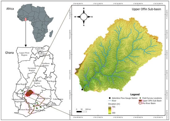
Figure 1.
Location and topography of the Upper Offin sub-basin in the Pra River Basin of Ghana.
2.2. Land Use and Agriculture
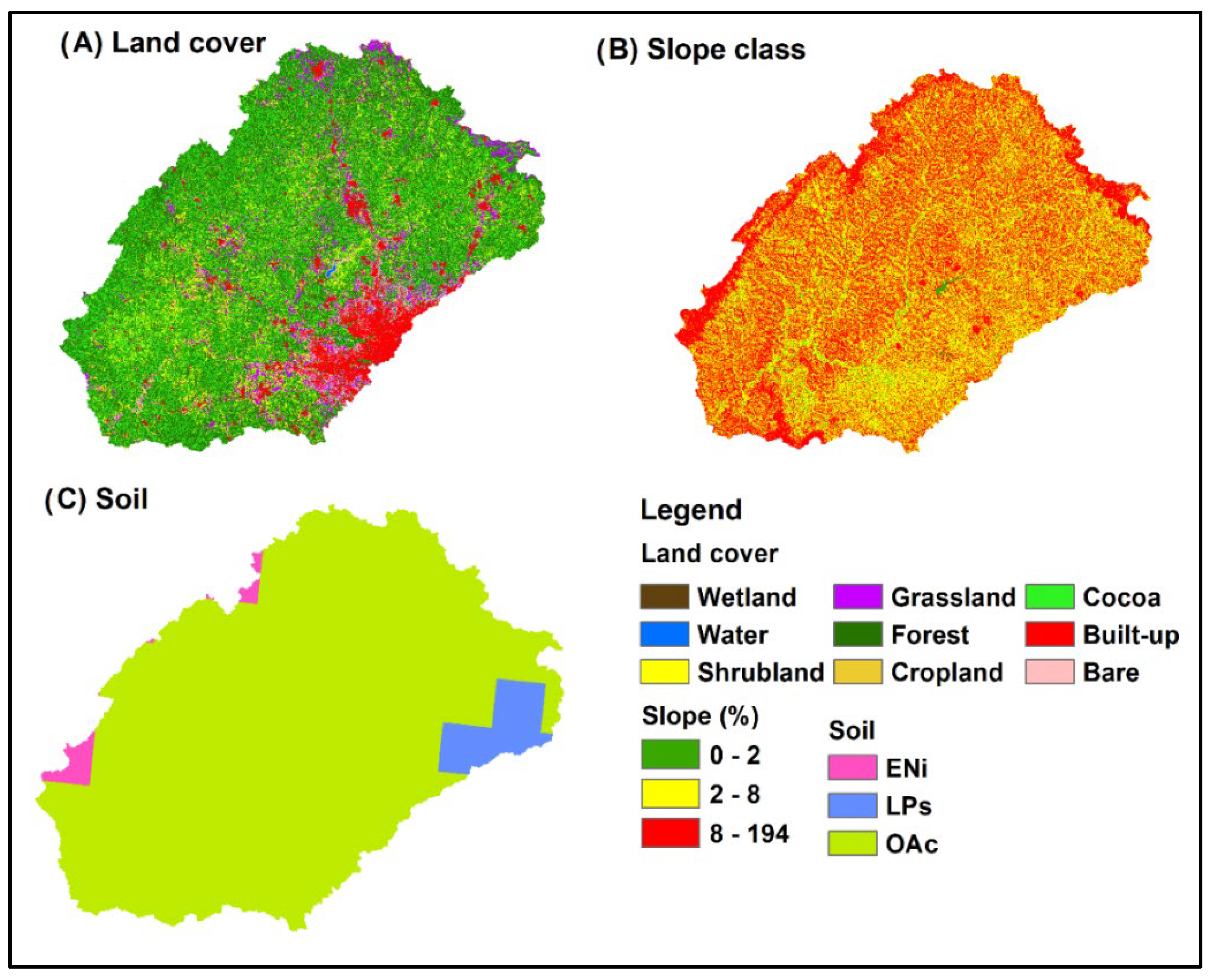
The sub-basin is dominated by Orhic Acrisols, sandy clay loam texture, covering 94% of the catchment. Land cover of the Upper Offin sub-basin, Figure 2A, is dominated by forest (~42%) followed by cocoa farmland (~31%), and shrubs (~11%). Croplands account for less than 0.5% of the sub-basin. The predominant landscape slope in the sub-basin, as depicted in Figure 2B, shows that 45% of the area has a slope above 8%, while 40% falls between a 2% to 8% slope. Approximately 34% of the sub-basin has slopes below 2%, and 21% have slopes exceeding 8%. Orthic Acrisols (OAc), which fall under hydrologic group C, is the predominant soil type, covering 94% of the sub-basin (Figure 2C). The landscape is also dominated by lateral subsurface flow and depression storage on the hillslope because of the dominant land uses of forest and cocoa [22]. Obalum et al. [23] also described the landforms of this landscape where depression storage is prevalent.

Figure 2.
Spatial catchment characteristics of the Upper Offin sub-basin; (A) land cover, (B) slope classes, (C) soil.
Farming, including crop production, livestock, forestry, and fishery, is the primary source of livelihood in the sub-basin [24]. The average landholding in the districts is 2.0 hectares [25] The main rainfed crops in central Ghana are maize, sorghum, groundnut, cocoa, yam, and cassava [26,27]. Irrigated agriculture covers only about 3.2% of the country’s arable land [28].
2.3. Hydrogeology
Geologically, the Upper Offin sub-basin is predominantly underlain by metavolcanic and metasedimentary rocks of the Birimian supergroup, which are intruded by biotite-rich and undifferentiated granitoid of the Eburnean plutonic suite (Figure 3), following the Eburnean orogenic event, some 2.1 billion years ago, at or after the end of the Birimian deposition [29,30,31,32]. These formations, which underline approximately 96% of the study area, have been further intruded by mafic dolerite Dikes of the Mesozoic age, accounting for an additional 2% of the area’s geology. Furthermore, detrital sandstone and conglomerate of the Tarkwaian group and fine to medium-grained sandstones of the Kwahu-Morago group of the Voltaian supergroup, are noted to underlie the remaining 2% of the study area.
The hydrogeology of the Upper Offin sub-basin is characterized by limited primary porosity and permeability due to its predominantly crystalline rock formations. According to a reclassification of the hydrogeology of Ghana by Banoeng-Yakubu et al. [33], the study area falls within the Birimian and Crystalline basement granitoid complex hydrogeological provinces. Groundwater flow in these provinces is mainly through secondary structures such as fractures, joints, and shear zones formed by tectonic processes and weathering of rocks, leading to the development of fractured and weathered zone aquifers. Consequently, the yielding capacities of these aquifers are dependent on the extent of these secondary permeabilities, which are spatially variable [34].
Borehole drilling records in the study area indicate that average borehole depths are 42 m in the Birimian rocks, and 60 m in the granitoid due to the typically low success rates in the latter [34]. The Birimian rocks are among the highest-yielding aquifers in Ghana, with an average yield of 12.7 m3 h−1, a transmissivity of 7.4 m2 d−1, and storativity ranging between 0.003 and 0.008 [35]. These characteristics suggest that the Birimian rocks have significant potential for groundwater abstraction, supporting domestic and agricultural water needs. However, borehole yields in the granitoid are highly variable, depending on the extent of weathering, and typically range from 0.1 to 30.0 m3 h−1 with a mean value of 2.0 m3 h−1.
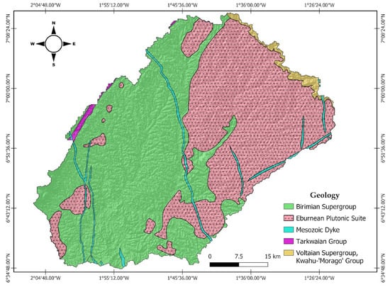
Figure 3.
Geological map of the Upper Offin sub-basin (Source: Agyei Duodu, 2009 [36]).
Figure 3.
Geological map of the Upper Offin sub-basin (Source: Agyei Duodu, 2009 [36]).
3. Materials and Methods
3.1. Framework of the Study
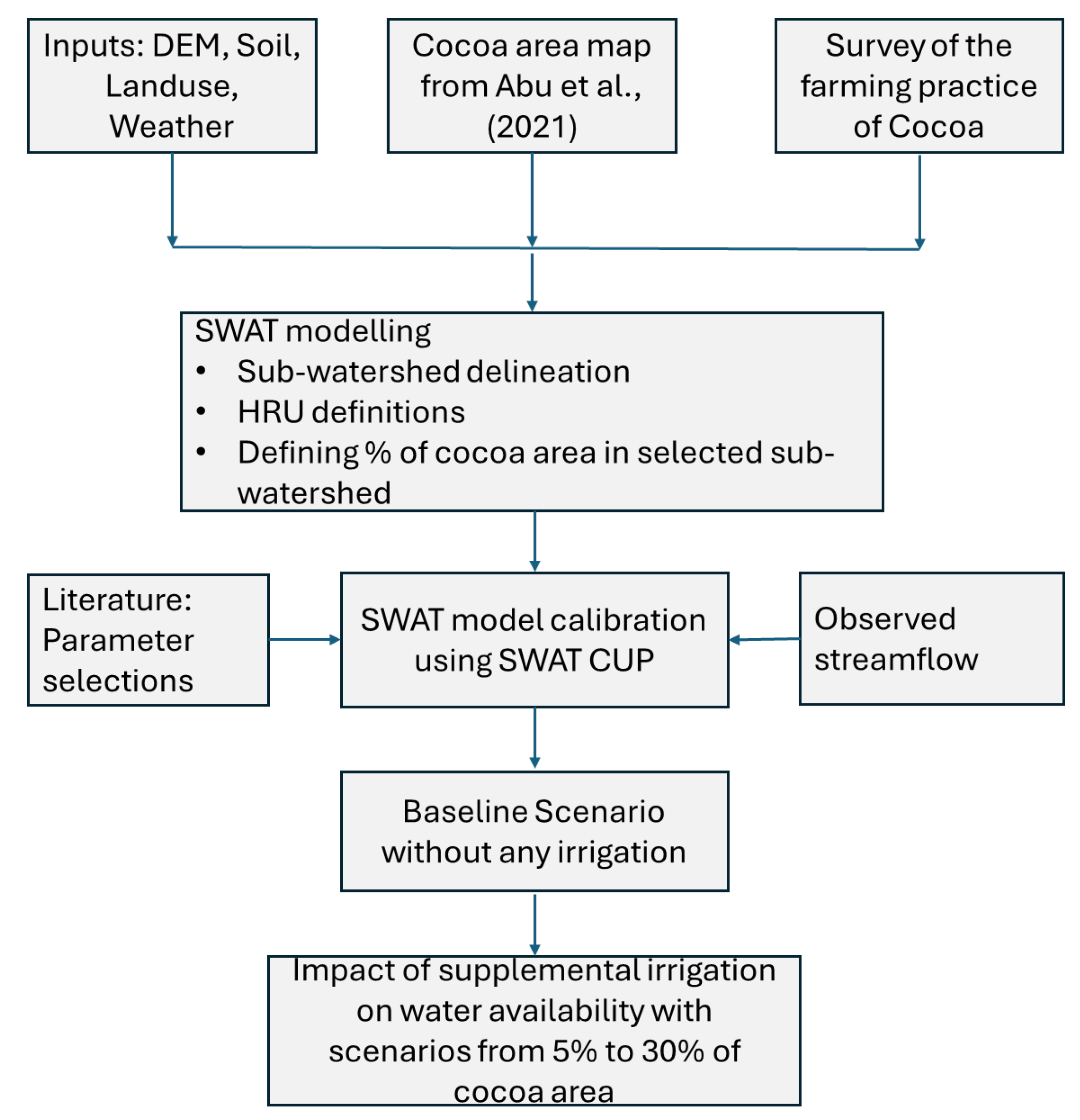
A hydrological modeling framework, Figure 4, was used to evaluate the status of water resource availability when converting rainfed cocoa production to an irrigated system. Examining the impacts of irrigated cocoa production hinges upon a comprehensive understanding of the underlying hydrology at the watershed level.
In this study, we used the Soil and Water Assessment Tool (SWAT) model, version 2012, to understand the underlying hydrology in the Upper Offin sub-basin. The model setup was used to evaluate the impacts of various proportions of cocoa farms being irrigated during dry periods (November to March) on hydrology and water resource availability. The SWAT model uses weather data, digital elevation model, soil, and land uses as input to simulate the hydrology of a catchment [14].
Streamflow data were used to calibrate the hydrology model and literature values on water balance components were used to compare the results. The model was calibrated using the SWAT-CUP (Calibration and Uncertainty Procedure) until a reasonable performance was obtained. The sub-basin was characterized based on the hydrologic balance of each sub-watershed using an area-weighted average. A shallow groundwater source was considered a source of irrigation for cocoa production. Some portions of the rainfed cocoa area were converted to a supplemental irrigated system. The proportion of the area with a supplemental irrigation system varied from 5% of the cocoa farm area to 30%, with 5% increments as different scenarios. The impacts of irrigation on water resource availability for various cocoa farms were analyzed separately. An optimized irrigation water withdrawal from shallow groundwater was suggested considering the ecosystem.
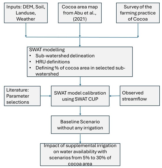
Figure 4.
Framework to evaluate the impacts of cocoa supplemental irrigation during the dry period on the status of water resource availability in the Upper Offin sub-basin [37].
Figure 4.
Framework to evaluate the impacts of cocoa supplemental irrigation during the dry period on the status of water resource availability in the Upper Offin sub-basin [37].
3.2. SWAT Model Description
The SWAT model is a globally recognized hydrological model used for water resource assessment [38] and evaluation of watershed management practices such as irrigation [39]. In SWAT, a watershed is divided into sub-basins based on topography, and each sub-basin is further conceptually divided into hydrologic response units (HRUs) based on slope, soil, and land use [40]. The HRUs have a unique combination of land use, soil, and slope. The SWAT model simulates the soil water content, surface runoff, evapotranspiration, sediment yield, plant growth, and the impacts of management practices at the HRU level, and then aggregates these results at the sub-watershed level [41]. The general water balance equation used in SWAT is shown in Equation (1). We used monthly time step in our analysis. A detailed description of the model’s conceptual framework and simulation strategies is copiously documented in [14,42].
where SWt−1, Pi, Qsurf,i, ETi, Qloss,i, Qgw,i are soil water content above the wilting point at the end of day t, amount of precipitation on the day i, the daily amount of surface runoff, evapotranspiration, percolation into the deep aquifer, and lateral sub-surface flow, respectively. All components are estimated in the units of mm.
3.3. SWAT Model Setup
First, the SWAT model inputs were obtained and prepared based on the model format. Given the river outlet location at Adiembra, the 30 m Digital Elevation Model (DEM) was used to delineate the watershed and generate drainage patterns and associated topographic characteristics. The land use and soil data, in combination with DEM, were used to create HRUs. Weather data such as rainfall from CHRIPS, temperature from ERA5, and wind speed, relative humidity, and solar radiation from CFSR for the period from 1998 to 2019 were used as inputs to the SWAT model. The Upper Offin sub-basin was classified into 20 sub-watersheds and HRUs were defined considering 5%, 10%, and 20% thresholds for land use, soil, and slope, respectively [13]. A total of 147 HRUs were obtained during the SWAT model setup in the Upper Offin sub-basin.
3.4. Model Data Inputs
Hydrological modeling using SWAT relies on a wide range of time series and spatial data. In this study, the spatial and time series data used are indicated in Table 1 to simulate the various components of the hydrological cycle [43]. The spatial data inputs include the Digital Elevation Model (DEM), soil characteristics, and land use/cover information. We used a cocoa farm area map with a 10 m by 10m resolution to locate cocoa areas in the Upper Offin sub-basin.

Table 1.
Data types and their sources used for water availability assessment.
Farming practice data such as planting time, plant density, tillage practices, fertilizer, and pesticide applications were collected through surveys in July 2023 involving 16 farmers in the Upper Offin sub-basin and its surrounding cocoa-producing area (Supplementary Materials File S1). Data for this study were gathered directly from cocoa farmers in Ghana’s Ashanti, Brong-Ahafo, Central, Eastern, and Western North and South cocoa regions. The farmers were identified through purposive sampling based on their involvement in irrigated cocoa production. The survey was gathered to obtain key information on the types, quantities, and timing of different agricultural practices, providing a comprehensive overview of current cultivation methods in the area. The mean value of average planting time of cocoa, plant spacing, fertilizer rate, and pesticide application were incorporated into the SWAT management file. This was due to the necessity of adopting dominant or representative farm management in the SWAT management file.
The time series data include the weather data, which include precipitation, maximum and minimum air temperature, relative humidity, wind speed, and solar radiation (Table 1). In addition, the model requires streamflow records, or evapotranspiration, or combinations of these data to calibrate and validate the various hydrological components. This study used observed streamflow records at the Adiembra station to calibrate the SWAT model and validate the hydrological balance.
3.5. Model Sensitivity Analysis, Calibration, and Validation
Based on an ongoing field observation in the micro-watershed of the Upper-Offin sub-basin and its preliminary analysis, Adusei-Gyamfi et al. [22] identified that subsurface flow is vital in this landscape. In addition, depression storage is prevalent in the forest and cocoa-tree-dominated hillslope and the valley bottom landscape [23]. Therefore, we prioritized SWAT parameters that control the subsurface flow and overland flow. For this reason, we followed Worqlul et al. [40]’s identified 16 calibration parameters and their ranges, Table 2, for the SWAT model of Upper Offin sub-basin. For example, we included the depth of the impervious layer in the calibration because we assumed the dominance of lateral flow and depression storage in the landscape.
Table 2.
SWAT model selected parameters calibration for automated calibration and sensitivity analysis in SWAT-CUP based on Worqlul et al. [40].
In this study, we adopted these parameters as implemented by others, such as Assefa et al. [9]. The calibration parameters were constructed based on replacement (‘v_’) and a relative change (‘r_’) to the initial parameter value. A global sensitivity analysis was applied to identify parameters significantly influencing the stream flow. In the global sensitivity analysis, all parameters were allowed to change at the same time, followed by the estimation of the standard regression coefficient [40]. The t-stat and p-value were used to evaluate the significance of the relative sensitivity based on Nazari-Sharabian et al. [44]. The simulation period was divided into three: warm-up (1998 to 2000), calibration (2001 to 2008), and validation (2009 to 2011) based on streamflow data availability. Despite the rigorous calibration and validation process, it is worth noting that inherent uncertainties exist in hydrological modeling using SWAT. These include parameter equifinality [45] and model input uncertainties [46].
3.6. Model Performance Evaluation Criteria
Model performance was performed in two stages. The calibrated SWAT model’s performance in predicting streamflow during the calibration and validation period was evaluated using commonly used statistics described below. In addition, the actual evapotranspiration (ET) values of the 8-day composite and 500 m spatial resolution MODIS product (MOD16A2) were extracted at the sub-basin scale from the Google Earth Engine (GEE) platform. The time series data were extracted from 2000 to 2012. While the MODIS product offers valuable broad-scale ET estimates for model evaluation, its resolution may not fully capture the fine-scale heterogeneity of land use, soil, and slope in the sub-basin, particularly in complex landscapes. We compared SWAT sub-basins and spatial average output of the actual ET. We also compared the spatial average monthly SWAT actual ET with the conceptual hydrology model to evaluate if it’s monthly actual ET fits with the monthly MODIS ET, or the monthly SWAT ET. Thornthwaite Mather’s water balance-based PED (Parameter Efficient Distribution) model is the conceptual model chosen. The model is widely used in Africa and can predict overland flow, baseflow, interflow and actual ET [47]. More information about the model is provided in the Supplementary Materials File S2.
The performance of the calibrated SWAT model in predicting streamflow during the calibration and validation period was evaluated using commonly used statistics, R-squared (R2), Nash–Sutcliff Efficiency (NSE), and Percent BIAS (PBIAS). R-squared, Equation (2) varies from zero to one, where one value represents a perfect correlation, and the reverse refers to no correlation. NSE, Equation (3) value varies from negative infinity to one, where a value of one represents a perfect model simulation of the observed flow. A negative NSE value refers to the average of observed time series being better than the model predictions. The PBIAS, Equation (4), varies from negative to positive infinity, and the model performs best when the value is zero.
Furthermore, the calibrated model output of spatial average SWAT monthly actual ET was compared with an independent spatial average monthly MODIS-based actual ET product and water balance-based PED model. First, the time series MODIS actual ET was extracted for each sub-basin from 2001 to 2012 and then compared with the SWAT output using the coefficient of determination (R2). Then, the spatial average from all sub-basins was compared with the MODIS spatial average ET and PED ET. This statistical matrix measures any similarities in the temporal patterns between the three actual ET estimates.
3.7. Impacts of Irrigated Cocoa Production
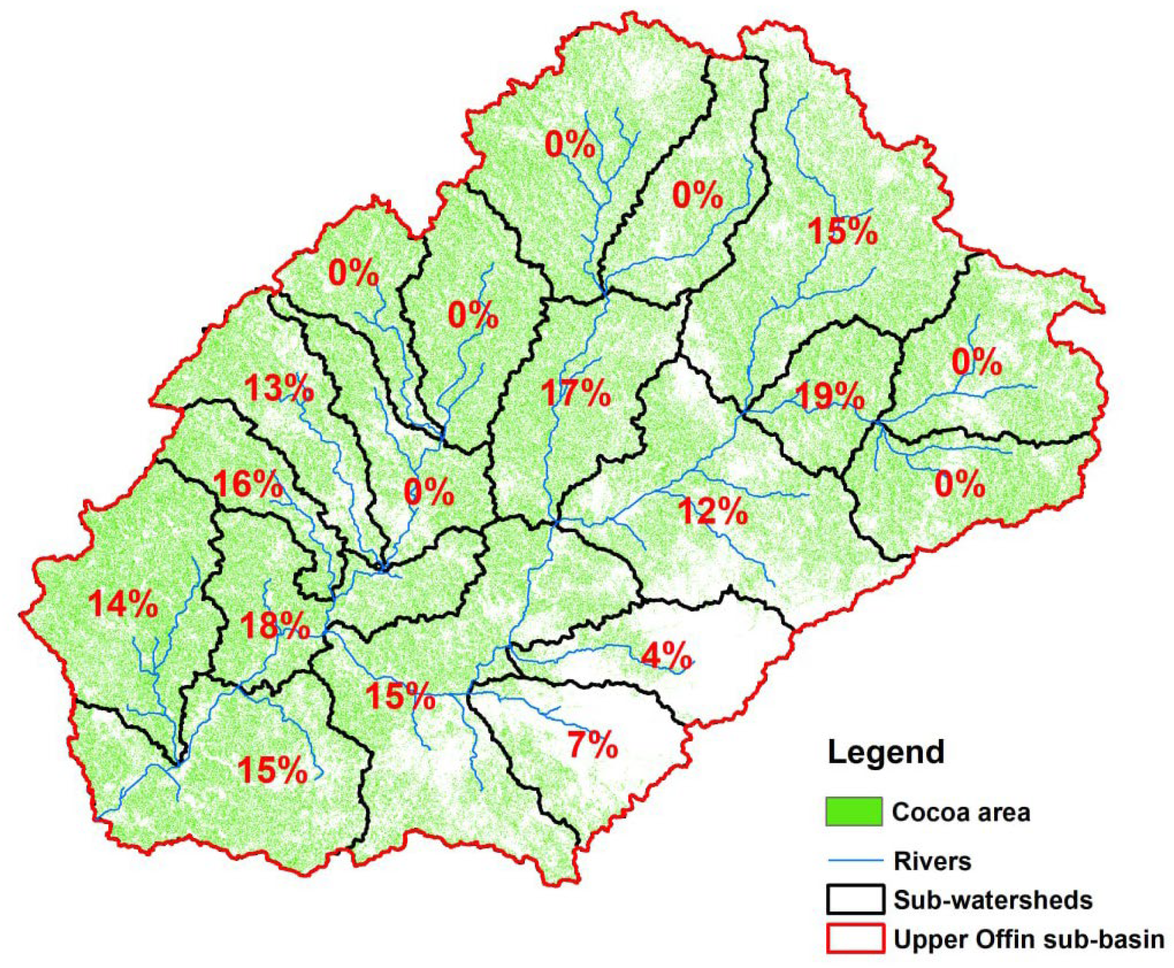
Hydrological simulation of the Upper Offin sub-basin was performed from 2001 to 2019 using the calibrated SWAT model to obtain baseline hydrologic balance. We considered a total of six supplemental cocoa farm irrigation scenarios (November to March every year), from 5% to 30% of the cocoa farm area at a 5% area increment from shallow groundwater. Figure 5 depicts the sub-watersheds where 30% of supplemental irrigation is applied. It does not mean that the green-colored sub-watersheds are fully irrigated. Instead, irrigation was applied to cocoa HRUs with gentle slopes in the green-colored sub-basin. The net irrigation requirement for irrigation was computed by deducting effective rainfall from the average irrigation requirement (130 mm per month) for cocoa farming [48]. The effective rainfall (Pe) was computed using the United States Department of Agriculture Soil Conservation Service (USDA-SCS) method [49]. The hydrologic balance of each supplemental irrigation scenario was compared with the baseline to observe impacts on water resource availability. A one-tailed paired ‘t’ test was used to evaluate the significance of hydrological changes under each supplemental cocoa farm irrigation. An optimized water withdrawal for cocoa irrigation was suggested based on changes in groundwater flow and catchment water yield.
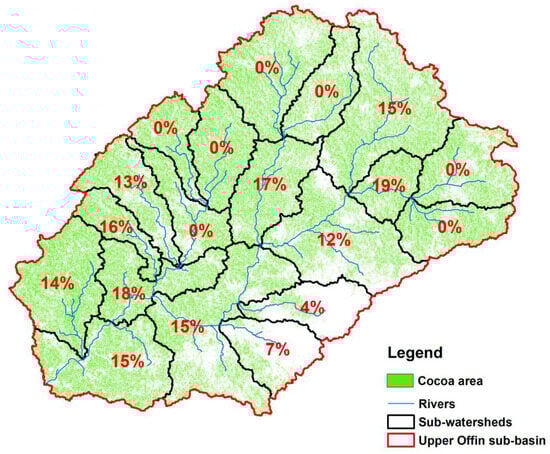
Figure 5.
Percent of sub-watersheds in the Upper Offin sub-basin where supplemental irrigation was applied to the cocoa area in SWAT. Note that the number in the map represents the percent area of each sub-watershed under supplemental irrigation.
4. Results
4.1. Cocoa Farm Management in the Area
The farm management survey, summarized in Table 3 and Supplementary Materials File S2, provides a comprehensive dataset covering key variables for assessing cocoa farm productivity and sustainability. The survey revealed that the average age of cocoa trees in the sub-basin and surrounding areas was approximately 19 years, with a plant density of about 1155 trees ha−1. The average cocoa yield was found to be 425 kg ha−1. Regarding inputs, 88% of the farmers had access to fertilizer, and 100% had access to pesticides. Regarding fertilizer application, 64% of the farmers use a single fertilizer, with 86% applying inorganic fertilizer types. Granular fertilizer (such as Asaase Wura and Cocoa Seed) was applied at an average rate of 371 kg ha−1 at least once every three years, while foliar fertilizers (such as Cocoasett) were used at 660 mL per ha annually. Organic fertilizers (such as poultry manure) were applied at 2500 kg ha−1 with a frequency of at least once every three years. The pesticide (such as Confidor, and Akati master) application rate was, on average, 470 mL ha−1 at least five times a year.
Table 3.
Field survey on cocoa farm management practices.
4.2. Sensitivity Analysis, Calibration, and Validation
The sensitivity analysis result for the Upper Offin sub-basin, Table 4, depicted that parameters related to the sub-basin, management, and groundwater were found to be sensitive to streamflow. Manning’s ‘n’, average channel slope, curve numbers, threshold depth of water in shallow aquifer for return flow to occur, and groundwater ‘revap’ coefficient were the top five most sensitive parameters in their order of sensitivity. Previous studies that employed the SWAT model in the Owabi catchment [50] and Pra River Basin [17] identified 11 and 8 sensitive parameters, respectively, the same as our findings. The relative sensitivity order of parameters was not presented in those previous studies.
Table 4.
Parameter sensitivity analysis and calibration results for the Upper Offin sub-basin.
The SWAT-CUP model calibration and uncertainty analysis result in the fitted parameter values, as shown in Table 4, which reproduce the streamflow of the Upper Offin sub-basin with reasonable performance. The performance of the model at monthly scale, Figure 6A,B, was good during calibration (R2 of 0.70, NSE of 0.70, and PBIAS of 3.9) and satisfactory validation (R2 of 0.68, NSE of 0.66, and PBIAS of 12.8) based on Moriasi et al. [51].
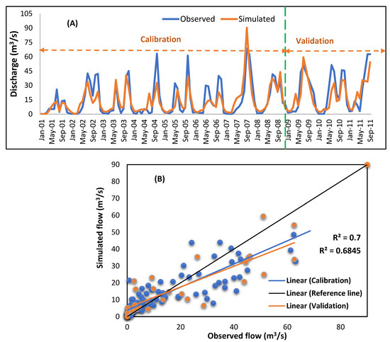
Figure 6.
Time series (A) and scatter plot (B) for the calibration (2001 to 2008) and validation (2009 to 2011) of monthly streamflow results at the Adiembra gauging station. The green broken line indicates the border of the time period for calibration and validation.
The overall model prediction slightly underestimated the observed flow (Figure 6A,B) except for 2007 and 2009. From 2001 to 2008, the mean monthly observed discharge was 14.0 m3/s, whereas it was 13.3 m3/s for simulated flow. Similarly, from 2009 to 2011, the mean monthly observed flow was 20.4 m3/s, while the simulated flow was 17.8 m3/s. The good model performance during calibration and validation demonstrate the SWAT model’s capability to reliably simulate the hydrological process in the Upper Offin sub-basin. This established confidence on the applicability and suitability of the model for evaluating the hydrological implications of supplemental irrigation.
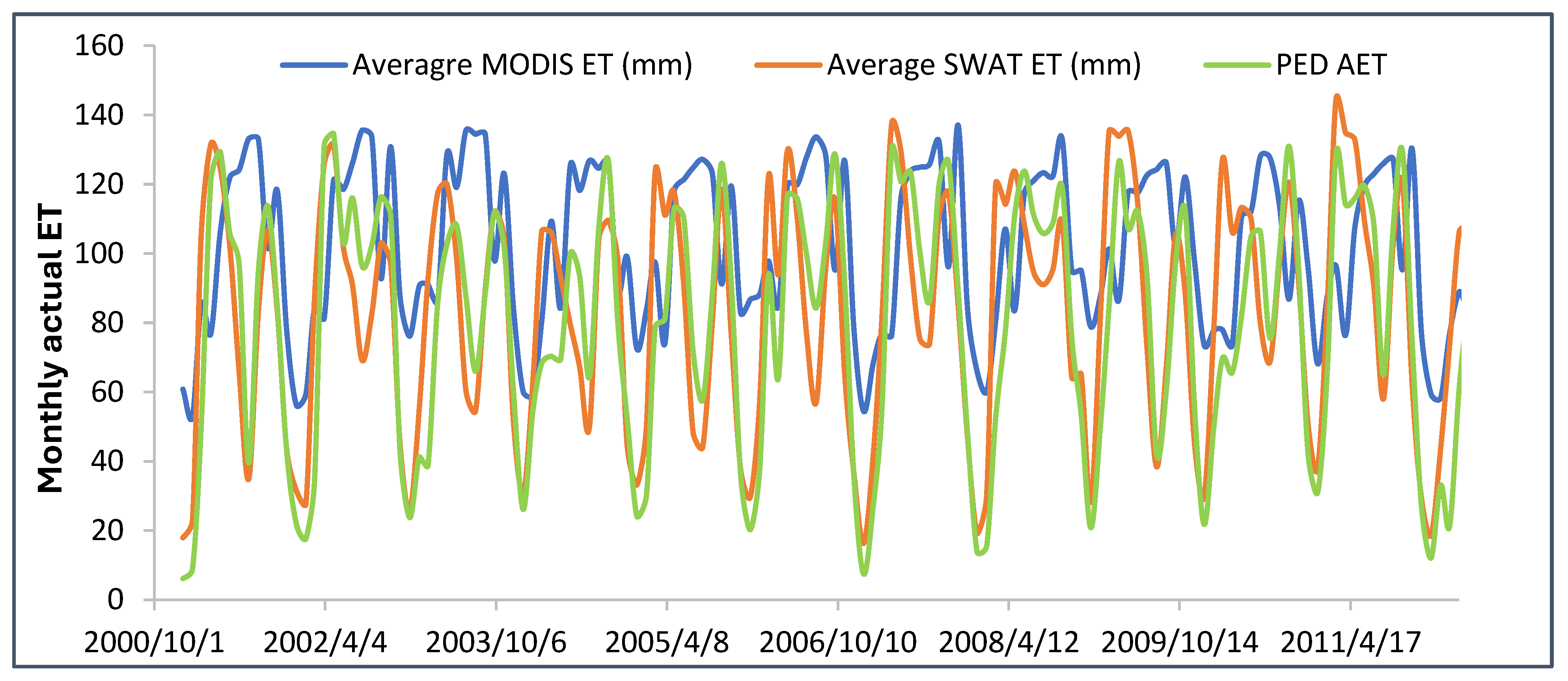
To verify SWAT model performance in capturing ET, the dominant water balance component, ET value from a previously established model in the sub-basin, PED (Parameter Efficient Distribution), was compared. A comparison with an independent remote sensing-based product, MODIS actual ET, often used in data-scare regions, was also made to highlight its applicability in the sub-basin. The comparison of the SWAT actual ET from 20 sub-basins with MODIS ET was very poor with R2 of less than 0.2. However, the comparison of spatial average ET of SWAT, MODIS, and PED (Figure 7) showed an R2 of 0.68 between SWAT ET and PED ET, while it is less than 0.1 between SWAT ET and MODIS ET (Supplementary Materials File S2). The MODIS ET algorithm estimates surface conductance based on vegetation indices and meteorological data but does not explicitly account for soil moisture constraints [52]. Given the strong consistency between SWAT ET and PED ET, as well as alignment of parameters with the literature [17], we feel that the SWAT model provides a more reliable representation of streamflow and ET in the Upper Offin sub-basin.
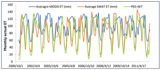
Figure 7.
Monthly time series comparing the spatial average MODIS ET, average SWAT ET, and PED AET in Upper Offin sub-basin.
4.3. Hydrologic Response of the Upper Offin Sub-Basin, Baseline
From 2001 to 2019, the Upper Offin sub-basin experienced a mean annual rainfall of 1333 mm (Figure 8). During this period, evapotranspiration was the predominant hydrological process, constituting 71% of the mean annual rainfall, followed by percolation, which accounted for 21%. Meanwhile, surface runoff and sub-surface flow account for 5% and 3% of the mean annual rainfall. Catchment water yield, WYLD, is about 14% (183.5 mm) of the mean annual rainfall.
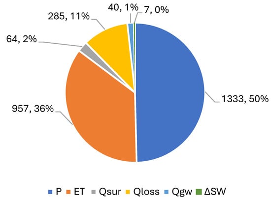
Figure 8.
Hydrologic responses of the Upper Offin sub-basin. P, ET, Qsur, Qloss, Qgw, and ∆SW were precipitation, evapotranspiration, surface runoff, percolation, lateral sub-surface flow, and change in soil water, respectively. All units are in mm or (%).
Previous studies in the region have reported different estimates of evapotranspiration. For instance, Osei et al. [50] noted that it comprised 55% of the mean annual rainfall in the Owabe catchment, while ACHEAMPONG [53] and Awotwi et al. [17], estimated 60% and 80% of the mean annual rainfall as evapotranspiration in the Pra River Basin, respectively. The above suggests that a substantial portion of rainfall is lost to the atmosphere, potentially limiting water availability for other uses, such as agriculture and recharging of groundwater. Compared to other regions within the Pra River Basin, where evapotranspiration estimates range from 55% to 80%, the Upper Offin sub-basin exhibits a relatively high rate, which could have implications for water resource management strategies, particularly in maintaining sufficient water levels for sustainable use and ecological balance in the basin.
4.4. Spatial Hydrology and Impacts of Supplemental Irrigation
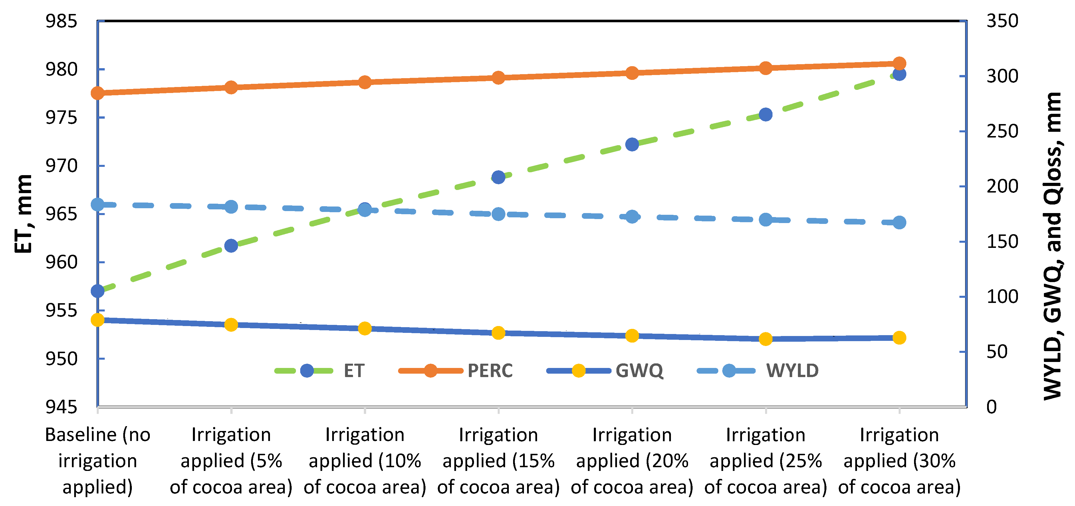
The results depicted the impacts of different supplemental irrigation scenarios on water resources and the environment. Figure 9 demonstrates how expanding cocoa supplemental irrigation fundamentally alters the hydrological process. For instance, a significant expansion of irrigated cocoa area to 30% of the total cocoa area resulted in noticeable shifts in the water balance components. We observed a 2.3% increase in actual ET, indicating enhanced water consumption by irrigated cocoa plants, and a 9% increase in Qloss. The increase in percolation from the baseline indicates that some of the irrigation water applied infiltrates deeper to the soil profile.
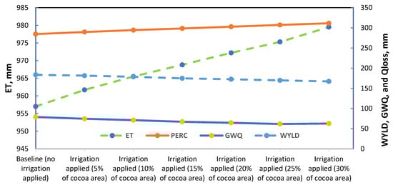
Figure 9.
Hydrologic responses of the Upper Offin sub-basin due to expansion of supplemental irrigation. P, ET, Qsur, Qloss, GWQ, SSF, and WYLD were precipitation, evapotranspiration, surface runoff, percolation, groundwater flow, sub-surface flow and, and water yield, respectively. All units are in mm.
Conversely, the most prominent and environmentally significant changes were observed in groundwater flow (GWQ) and water yield (WYLD). Groundwater flow experienced a substantial 25% decrease from the baseline, while water yield declined by 9% compared to the baseline. Further analysis revealed a statistically significant (p < 0.05) reduction in groundwater when supplemental irrigation was applied to just 5% of the cocoa area. On the other hand, increasing the irrigated area to 30% of the cocoa area did not significantly impact catchment water yield. Moreover, no significant changes were observed in surface runoff, sub-surface flow, and soil moisture, with up to 30% cocoa area coverage using supplemental irrigation.
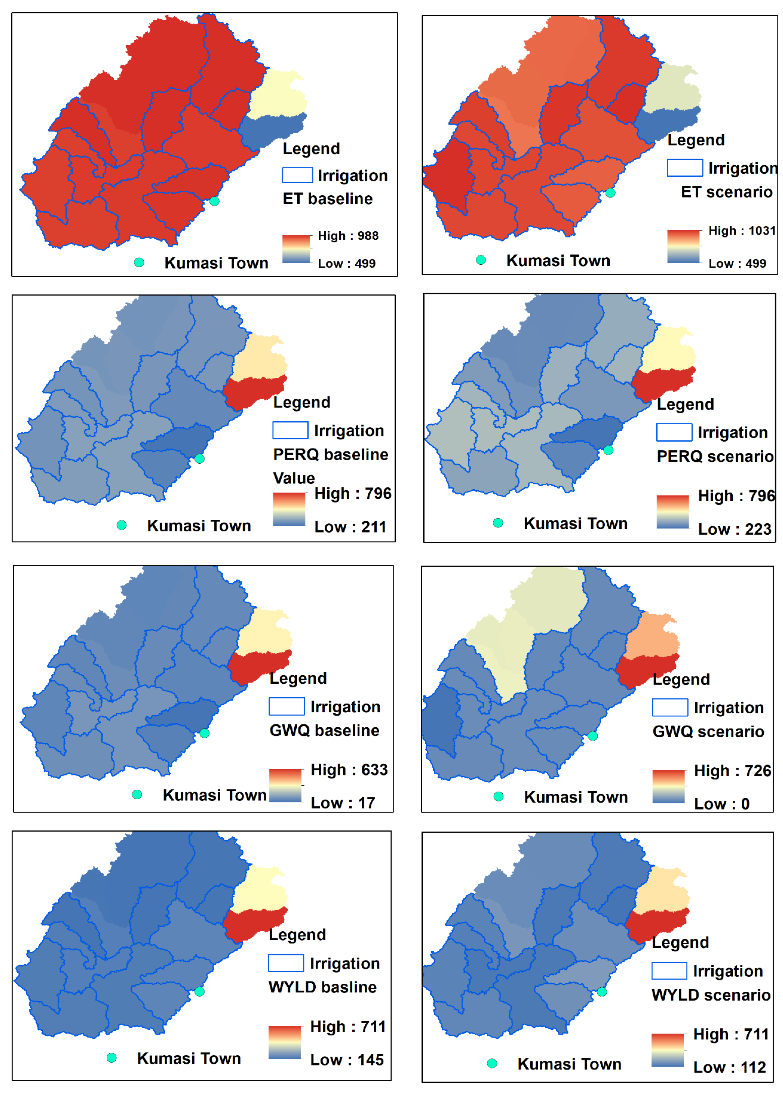
The spatial hydrological responses of the baseline scenario showed that two sub-watersheds, northeast of the Upper Offin, showed uniquely different hydrological responses (Figure 10, left). Catchment water yield, groundwater flow, and percolation were observed to be high compared to the other parts of the Upper Offin sub-basin, while evapotranspiration was low. This was mainly due to the soil characteristics, such as Leptosol soil (Figure 2C), which is under hydrologic group B and has a good infiltration capacity. The dominant soil of Upper Offin is under hydrologic group C. Percolation and groundwater flow were low, while surface runoff was high in the southeast of the Upper Offin watershed, where built-up areas and bare lands are dominant (Figure 2A). Kumasi, the second largest city in the country, is in the southeast of the Upper Offin sub-basin. These findings underscore the need for careful management of irrigation practices to balance crop water needs with the sustainability of groundwater resources, particularly in areas with varying soil characteristics and land use patterns.
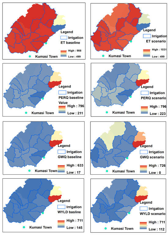
Figure 10.
Spatial hydrologic responses of the Upper Offin sub-basin for baseline and irrigation scenario.
Conversely, the impacts of supplemental irrigation on spatial hydrology revealed considerable changes within the sub-basin where irrigation was implemented (Figure 5). Particularly, the sub-watersheds containing cocoa plantations that benefited from supplemental irrigation exhibited notable increases in evapotranspiration and percolation rates (Figure 10, right). The increase in evapotranspiration and percolation can be attributed to the additional water availability from the shallow aquifer to the surface. However, a notable reduction in groundwater flow and catchment water yield was observed in areas where supplemental irrigation was a cocoa plantation. Therefore, these changes highlight the need for careful management and monitoring of irrigation practices to ensure that the benefits of increased agricultural productivity do not come at the expense of long-term water resource sustainability.
5. Discussions
The increasing unsustainability of rainfed cocoa farming due to erratic rainfall and prolonged droughts aligns with broader trends observed in other cocoa-producing regions across Africa, such as Côte d’Ivoire, Nigeria, and Cameroon. Studies have consistently highlighted the vulnerability of cocoa production to climate variability, emphasizing the need for adaptive strategies, including supplemental irrigation [54]. The findings from the Upper Offin sub-basin in Ghana demonstrate the feasibility of utilizing shallow groundwater for dry-season irrigation. Similar approaches have been explored in West African cocoa landscapes, where water availability remains critical for sustaining productivity and securing smallholder farmers’ incomes [11]. In this section, we discuss our finding of groundwater potential with other studies and its geological context, innovation in the irrigation, and future challenges.
5.1. Groundwater Potential for Supplemental Irrigation of Cocoa
The potential of irrigated cocoa production can be realized through the optimized use of irrigation practices, which plays a key role in enhancing cocoa productivity while maintaining the sustainability of water resources. In the Upper Offin sub-basin of Ghana, there is a significant opportunity to boost cocoa production through supplemental irrigation. The result suggests that supplemental irrigation could be applied to at least 5% of the cocoa cultivation area, equivalent to 4760 ha, without causing significant impacts on groundwater flow. This estimate is based on land use, which shows that cocoa accounts for a substantial portion of the forest land. Using the average irrigated cocoa land size per household, which is 3 ha (Table 3), this translates to the potential for more than 1580 households (i.e., quotient of 4760 ha and 3 ha per household) to practice supplemental irrigation sustainably.
These estimates assume that each participating household would irrigate up to 3 ha on average, consistent with observed practices. Moreover, the groundwater impact assessment assumes that the current hydrological and recharge conditions remain stable under this irrigation scale. The implication is that targeted, small-scale irrigation support to around 1580 cocoa farming households could enhance productivity without placing stress on groundwater resources. In addition, irrigated cocoa production could be extended to up to 30% of the cocoa area (28,540 ha or over 9500 households) without significantly reducing catchment water yield. These irrigation practices also support environmental demands for groundwater use, as indicated by R. van der Meulen et al. [55]. A detailed groundwater study using a distributed model integrated with field observations is essential to determine the long-term sustainability of expanded cocoa supplemental irrigation.
Groundwater potential in Ghana holds significant promise for addressing water scarcity issues, particularly in the agricultural sector [56]. The country’s diverse hydrological information, including fractured crystalline basements and sedimentary basins, offers considerable groundwater resources [57]. Despite seasonal variability and limited surface water availability, consistent yield from aquifers provides a reliable water resource for irrigation. In regions like Ashanti, Eastern, and Western regions, where cocoa production is predominant, leveraging groundwater for irrigation can enhance cocoa yields and improve crop resilience against climate variability [58]. Sustainable management of groundwater resources is vital to maintaining ecological balance and preventing over-extraction [59].
To fully realize the potential of supplemental irrigation for cocoa production in the Upper Offin sub-basin, it is crucial to implement sustainable water management practices that balance the needs of cocoa farmers with the long-term health of groundwater resources. This involves not only optimizing irrigation techniques but also investing in monitoring systems to track groundwater levels and usage rates, ensuring that extraction does not exceed natural recharge rates. Additionally, integrating supplemental irrigation with rainwater harvesting and conservation practices could further reduce dependency on groundwater, making cocoa production more resilient to climate variability. Collaborative efforts involving local communities, government agencies, and agricultural organizations are essential to develop guidelines and policies that promote the efficient use of groundwater while protecting it from over-exploitation. Moreover, educating farmers on sustainable irrigation practices and the importance of groundwater conservation will be key to maintaining both agricultural productivity and environmental health in the region.
Additionally, as attention is drawn towards supporting cocoa farmers to purchase and use irrigation equipment through financial modalities [12], stakeholders must also consider investing in the management of the water source, as cocoa irrigation is heavily dependent on groundwater use amid the growing pollution of surface water due to illegal mining activities in cocoa-producing communities. Supporting these farmers to access irrigation technologies would result in many farmers using groundwater, which could affect water resource availability. Failure to invest in water management practices could lead to unsustainable groundwater use. If groundwater is reduced due to overuse, the irrigation equipment would not be used, making them idle, which could result in bad investments.
5.2. Innovations in Irrigation
Integrating solar-based pumping systems with groundwater irrigation presents a feasible and innovative solution for irrigated cocoa production in Ghana [12]. Solar pumps offer an environmentally friendly and cost-effective alternative to traditional diesel-powered pumps [60], reducing reliance on fossil fuels. The system reduces operational costs and carbon emissions, making it an ideal choice that aligns with sustainable agricultural practices and contributes to global efforts to mitigate climate change. Furthermore, adopting innovation bundles, including modern irrigation technologies, water-saving practices, and farmer training programs [27], enhances efficiency and productivity. These innovation bundles provide the technical tools needed for improved water management and empower farmers with the knowledge and skills required to maximize the benefits of these technologies, leading to more resilient and productive agricultural systems. Financial constraints (high initial costs, and limited affordable credit), supply chain issues, and a deficit in local technical expertise represent the most significant adoption barriers.
Implementing an efficient water application system in the sub-basin can substantially expand the potential of irrigated cocoa areas by optimizing water use and ensuring that water resources are utilized most effectively. For instance, using advanced technologies such as drip and sprinkler irrigation systems would significantly improve water productivity by delivering water directly to the plant roots, minimizing evaporation and runoff. These systems enhance crop productivity by ensuring that cocoa plants receive the precise amount of water needed for optimal growth, supporting the ecosystem simultaneously [61]. In addition, adopting water-saving practices holds considerable potential to improve both water and crop productivity, further contributing to the sustainability and efficiency of cocoa farming in the region. These practices not only conserve valuable water resources but also help to maintain soil health and reduce the environmental footprint of agricultural activities, ensuring that cocoa production in Ghana remains sustainable and resilient in the face of changing climatic conditions.
5.3. Future Challenges with Available Resources
However, mining activities in the Upper Offin sub-basin pose a significant threat to water resources. The region’s rich mineral deposits have attracted extensive mining operations, leading to a decline in water availability, affecting both catchment water yield and groundwater recharge, and severely degrading water quality through increased sediment yield and contamination. Assefa et al. [9] explained that even a 5% mining coverage in the Upper Offin sub-basin could result in a 7% reduction in catchment water yield and a 5% decrease in percolation, alongside a dramatic 81% increase in sediment yield, indicating a significant impact on the hydrological balance. Furthermore, mining activities can introduce heavy metals and other pollutants into water bodies, making the water unsafe for agricultural and domestic use [62]. This contamination exacerbates the already critical issue of water scarcity. It highlights the competition for water resources between mining and agriculture, which can lead to conflicts and necessitates stringent regulations and continuous monitoring to safeguard the region’s water security.
Research conducted in various basins in Ghana, such as the White Volta River basin and the Pra Basin, has revealed that precipitation plays a crucial role in groundwater recharge, as evidenced by stable isotopes indicating peak recharge periods during specific rainy months [63]. Studies also suggest that regional groundwater flow systems are key to recharge, especially in areas with uniform hydraulic conductivity fields, based on simulations in Northern Ghana [64]. Moreover, the assessment of granitic aquifers in Ghana has underscored the potential of managed aquifer recharge (MAR) to support groundwater resources, highlighting the importance of site-specific conditions in recharge mechanisms [53]. The lack of detailed and specific investigations for the Upper Offin River Basin makes it difficult to definitively ascertain the dominant recharge processes. However, considering the study area’s climatic conditions and hydrogeological settings, both local recharge from precipitation and regional recharge from basin transfer could have significant implications for water availability and sustainability.
Efficient water resource management in the Upper Offin sub-basin of Ghana and in the West Africa region requires carefully balancing various water uses to ensure sustainability. With agriculture being a primary water use, precise water allocation models are necessary to optimize usage without depleting resources. These models must consider current and future demands, including the impacts of population growth, climate change, and potential shifts in land use. Future research in the Upper Offin sub-basin should focus on developing integrated water resource management strategies that harmonize the competing needs of agriculture, mining, and other water withdrawals. Such modeling practices need parameterization of the crop growth phenology of cocoa to model crop yield under rainfed and irrigated conditions. Advancing such knowledge could significantly enhance water use efficiency in a landscape. Additionally, engaging local communities and stakeholders in water management decisions is crucial for fostering sustainable development and ensuring that water resources are managed in a way that benefits all users while preserving the ecological integrity of the sub-basin.
6. Conclusions and Recommendations
The traditional resilience of farming on the rainfed system is increasingly unsustainable due to erratic rainfall and prolonged droughts, posing significant risks to agricultural productivity and the livelihoods of smallholder farmers. This growing concern has sparked increased interest in supplemental irrigation as a means to enhance cocoa production and sustain the livelihoods of these farmers. The study highlighted the considerable potential of supplemental irrigation for boosting cocoa productivity in the Upper Offin sub-basin of Ghana. It was found that irrigation during the dry period from shallow groundwater could be applied to up to 30% of the cocoa farm area without significantly reducing catchment water yield, providing a viable pathway for increasing crop resilience against climate variability and securing farmers’ incomes.
The findings underscore the opportunity of using the available water resources to support sustainable cocoa production. This requires the integration of advanced technologies such as drip and sprinkler systems, which are designed to maximize water use efficiency. Additionally, integrating renewable energy sources, particularly solar-powered irrigation systems, could be encouraged as a key component of sustainable agricultural practices. These systems must be carefully tailored to local conditions to ensure long-term sustainability and minimize environmental impacts. However, it is important not to overlook the importance of implementing sustainable groundwater management practices to prevent over-extraction and maintain the ecological balance in the region. Comprehensive training programs for farmers on modern irrigation techniques, water-saving practices, and sustainable cocoa farming methods are essential, and both governmental and non-governmental organizations should support these to ensure widespread adoption and effectiveness.
Strengthening institutional frameworks is vital to facilitate the adoption of supplemental irrigation and sustainable water management practices. This includes developing incentives for farmers to adopt innovative irrigation technologies and ensuring they have access to the necessary agricultural inputs to implement these practices successfully. Further research on the long-term impacts of supplemental irrigation on cocoa productivity and the hydrological system should be prioritized, with regular updates to models and predictions to reflect the changing climate and environmental conditions. Moreover, local communities must actively engage in decision-making processes related to water resources management and cocoa farming practices. This inclusive approach ensures that stakeholders at all levels are informed, involved, and committed to the successful implementation of sustainable practices, which have the potential to improve productivity, enhance livelihoods, and ensure the sustainable management of water resources in the face of growing environmental challenges.
Supplementary Materials
The following supporting information can be downloaded at https://www.mdpi.com/article/10.3390/w17131841/s1, File S1: Farm management survey; File S2: Overview of the Parameter Efficient Distributed model and actual ET comparisons.
Author Contributions
T.T.A.: conceptualization, data curation, methodology, formal analysis, writing—original draft. K.K.G.: writing—review, editing. G.A.: writing—review, editing. Y.S.A.L.: writing—review, editing. Y.B.: writing—review, methodology. S.A.T.: conceptualization, data curation, methodology, writing—review, supervision. All authors have read and agreed to the published version of the manuscript.
Funding
This research was funded by the CGIAR Initiative on West and Central African Food Systems Transformation and additional support from the CGIAR Initiative on Excellence in Agronomy, which is grateful for the support of CGIAR Trust Fund contributors (www.cgiar.org/funders, accessed on 20 July 2024) for both.
Data Availability Statement
The dataset on elevation data is available at https://doi.org/10.1029/2005RG000183. The land use data are available at https://esa-worldcover.org/en/data-access. Soil data are available at https://soilgrids.org/ and https://zenodo.org/records/2525817. The cocoa farm use map is available at https://doi.pangaea.de/10.1594/PANGAEA.917473. Precipitation from CHRIPPS and temperature from ERA5 are available at https://app.climateengine.com/climateEngine. Relative humidity, solar radiation, and wind speed data are available at https://climatedataguide.ucar.edu/climate-data/climate-forecast-system-reanalysis-cfsr (all accessed on 20 July 2024).
Conflicts of Interest
The authors declare no conflict of interest.
References
- O’Brien, K.L.; Leichenko, R.M. Double exposure: Assessing the impacts of climate change within the context of economic globalization. Glob. Environ. Chang. 2000, 10, 221–232. [Google Scholar] [CrossRef]
- Walker, R.J. Population growth and its implications for global security. Am. J. Econ. Sociol. 2016, 75, 980–1004. [Google Scholar] [CrossRef]
- Adaawen, S.; Rademacher-Schulz, C.; Schraven, B.; Segadlo, N. Drought, migration, and conflict in sub-Saharan Africa: What are the links and policy options? Curr. Dir. Water Scarcity Res. 2019, 2, 15–31. [Google Scholar]
- Awuni, S.; Adarkwah, F.; Ofori, B.D.; Purwestri, R.C.; Bernal, D.C.H.; Hajek, M. Managing the challenges of climate change mitigation and adaptation strategies in Ghana. Heliyon 2023, 9, e15491. [Google Scholar] [CrossRef]
- Nyamekye, A.P.; Tian, Z.; Cheng, F. Analysis on the contribution of agricultural sector on the economic development of Ghana. Open J. Bus. Manag. 2021, 9, 1297–1311. [Google Scholar] [CrossRef]
- Asante, F.; Guodaar, L.; Arimiyaw, S. Climate change and variability awareness and livelihood adaptive strategies among smallholder farmers in semi-arid northern Ghana. Environ. Dev. 2021, 39, 100629. [Google Scholar] [CrossRef]
- Serdeczny, O.; Adams, S.; Baarsch, F.; Coumou, D.; Robinson, A.; Hare, W.; Schaeffer, M.; Perrette, M.; Reinhardt, J. Climate change impacts in Sub-Saharan Africa: From physical changes to their social repercussions. Reg. Environ. Chang. 2017, 17, 1585–1600. [Google Scholar] [CrossRef]
- Ofosu, A.; Minh, T.T. Small-Scale Irrigation Dialogue Space: Understanding the Scalability of Solar-Powered Irrigation in Ghana: Market Segmentation and Mapping Pump Suitability; CGIAR: Montpellier, France, 2021. [Google Scholar]
- Assefa, T.; Atampugre, G.; Tilahun, S.; Cofie, O. Modeling of Water Availability for Food System Transformation in Upper Offin Sub-Basin and Mankran Micro-Watershed of Ghana: Scenarios Analysis; CGIAR: Montpellier, France, 2023. [Google Scholar]
- Ingrao, C.; Strippoli, R.; Lagioia, G.; Huisingh, D. Water scarcity in agriculture: An overview of causes, impacts and approaches for reducing the risks. Heliyon 2023, 9, e18507. [Google Scholar] [CrossRef]
- Asante, P.A.; Rahn, E.; Zuidema, P.A.; Rozendaal, D.M.; van der Baan, M.E.; Läderach, P.; Asare, R.; Cryer, N.C.; Anten, N.P. The cocoa yield gap in Ghana: A quantification and an analysis of factors that could narrow the gap. Agric. Syst. 2022, 201, 103473. [Google Scholar] [CrossRef]
- Gbodji, K.K.; Quarmine, W.; Minh, T.T. Effective demand for climate-smart adaptation: A case of solar technologies for cocoa irrigation in Ghana. Sustain. Environ. 2023, 9, 2258472. [Google Scholar] [CrossRef]
- Assefa, T.; Atampugre, G.; Tilahun, S.; Cofie, O. Modeling of Water Availability for Food System Transformation in Upper Offin Sub-Basin and Mankran Micro-Watershed of Ghana: A Baseline Study; CGIAR: Montpellier, France, 2023. [Google Scholar]
- Arnold, J.G.; Moriasi, D.N.; Gassman, P.W.; Abbaspour, K.C.; White, M.J.; Srinivasan, R.; Santhi, C.; Harmel, R.; Van Griensven, A.; Van Liew, M.W. SWAT: Model use, calibration, and validation. Trans. ASABE 2012, 55, 1491–1508. [Google Scholar] [CrossRef]
- Samimi, M.; Mirchi, A.; Moriasi, D.; Ahn, S.; Alian, S.; Taghvaeian, S.; Sheng, Z. Modeling arid/semi-arid irrigated agricultural watersheds with SWAT: Applications, challenges, and solution strategies. J. Hydrol. 2020, 590, 125418. [Google Scholar] [CrossRef]
- Assefa, T.; Taye, M.T.; Ebrahim, G.Y.; Ruckstuhl, S. Status Report on Water Resources Availability, Accessibility and Technology Needs for Addressing Water Security Challenges in Dolo Ado and Bokolmayo Districts, Somali Regional State, Ethiopia; CGIAR: Montpellier, France, 2024. [Google Scholar]
- Awotwi, A.; Anornu, G.K.; Quaye-Ballard, J.A.; Annor, T.; Forkuo, E.K.; Harris, E.; Agyekum, J.; Terlabie, J.L. Water balance responses to land-use/land-cover changes in the Pra River Basin of Ghana, 1986–2025. Catena 2019, 182, 104129. [Google Scholar] [CrossRef]
- Awotwi, A.; Yeboah, F.; Kumi, M. Assessing the impact of land cover changes on water balance components of White Volta Basin in West Africa. Water Environ. J. 2015, 29, 259–267. [Google Scholar] [CrossRef]
- Atullley, J.A.; Kwaku, A.A.; Owusu-Ansah, E.D.; Ampofo, S.; Jacob, A.; Nii, O.S. Modeling the impact of land cover changes on water balance in the Vea catchment of Ghana, 1985–2040. Sustain. Water Resour. Manag. 2022, 8, 148. [Google Scholar] [CrossRef]
- Akpoti, K.; Dembélé, M.; Forkuor, G.; Obuobie, E.; Mabhaudhi, T.; Cofie, O. Integrating GIS and remote sensing for land use/land cover mapping and groundwater potential assessment for climate-smart cocoa irrigation in Ghana. Sci. Rep. 2023, 13, 16025. [Google Scholar] [CrossRef]
- Bessah, E.; Raji, A.O.; Taiwo, O.J.; Agodzo, S.K.; Ololade, O.O. The impact of varying spatial resolution of climate models on future rainfall simulations in the Pra River Basin (Ghana). J. Water Clim. Chang. 2020, 11, 1263–1283. [Google Scholar] [CrossRef]
- Adusei-Gyamfi, J.; Gyebi, A.; Amponsah, A.K.; Atampugre, G.; Tilahun, S.A.; Cofie, O. Evaluating Hydrological Dynamics and Water Quality in Agricultural Landscapes in Ghana’s Forest Transition Belt: A Citizen Science Approach; CGIAR: Montpellier, France, 2023. [Google Scholar]
- Obalum, S.E.; Nwite, J.C.; Oppong, J.; Igwe, C.A.; Wakatsuki, T. Variations in selected soil physical properties with landforms and slope within an inland valley ecosystem in Ashanti Region of Ghana. Soil Water Res. 2011, 6, 73. [Google Scholar] [CrossRef]
- Okorno, S. Assessing Climate Change and Variability Impacts on Water Resources and Smallholder Agriculture in the Offin Sub-Basin of Ghana; PAUWES: Tlemcen, Algeria, 2019. [Google Scholar]
- Issahaku, G.; Abdul-Rahaman, A. Sustainable land management practices, off-farm work participation and vulnerability among farmers in Ghana: Is there a nexus? Int. Soil Water Conserv. Res. 2019, 7, 18–26. [Google Scholar] [CrossRef]
- Callo-Concha, D.; Gaiser, T.; Ewert, F. Farming and Cropping Systems in the West African Sudanian Savanna. WASCAL Research Area: Northern Ghana, Southwest Burkina Faso and Northern Benin; ZEF Working Paper Series, No. 103; University of Bonn: Bonn, Germany, 2012. [Google Scholar]
- Amponsah-Doku, B.; Daymond, A.; Robinson, S.; Atuah, L.; Sizmur, T. Improving soil health and closing the yield gap of cocoa production in Ghana–A review. Sci. Afr. 2022, 15, e01075. [Google Scholar] [CrossRef]
- IWMI. Ghana Irrigation Sector Mapping; IWMI: Accra, Ghana, 2022. [Google Scholar]
- Gill, H.E. A Ground-Water Reconnaissance of the Republic of Ghana: With a Description of Geohydrologic Provinces; U.S. Government Printing Office: Washington, DC, USA, 1969. [Google Scholar]
- Hirdes, W.; Davis, D.; Eisenlohr, B. Reassessment of Proterozoic granitoid ages in Ghana on the basis of U/Pb zircon and monazite dating. Precambrian Res. 1992, 56, 89–96. [Google Scholar] [CrossRef]
- Kesse, G.O. The Mineral and Rock Resources of Ghana; A.A. Balkema: Rotterdam, The Netherlands, 1985. [Google Scholar]
- Loh, Y.S.A.; Yidana, S.M.; Banoeng-Yakubo, B.; Sakyi, P.A.; Addai, M.O.; Asiedu, D.K. Determination of the mineral stability field of evolving groundwater in the Lake Bosumtwi impact crater and surrounding areas. J. Afr. Earth Sci. 2016, 121, 286–300. [Google Scholar] [CrossRef]
- Banoeng-Yakubu, B.; Yidana, S.; Ajayi, J.; Loh, Y.; Aseidu, D. Hydrogeology and groundwater resources of Ghana: A review of the hydrogeology and hydrochemistry of Ghana. 2010. Available online: https://ugspace.ug.edu.gh/items/79e08cd7-a9a8-44f8-a6b3-0400312c5e98 (accessed on 1 July 2024).
- Dapaah-Siakwan, S.; Gyau-Boakye, P. Hydrogeologic framework and borehole yields in Ghana. Hydrogeol. J. 2000, 8, 405–416. [Google Scholar] [CrossRef]
- Carrier, M.-A.; Lefebvre, R.; Racicot, J.; Asare, E. Northern Ghana Hydrogeological Assessment Project. In Proceedings of the 33rd WEDC International Conference, Loughborough, UK, 7–11 July 2008. [Google Scholar]
- Agyei-Duodu, J.; Loh, G.K.; Boamah, K.O.; Baba, M.; Hirdes, W.; Toloczyki, M.; Davis, D.W. Geological Map of Ghana, 1:1000000; Geological Survey Department of Ghana (GSD): Accra, Ghana, 2009. [Google Scholar]
- Abu, I.-O.; Szantoi, Z.; Brink, A.; Robuchon, M.; Thiel, M. Detecting cocoa plantations in Côte d’Ivoire and Ghana and their implications on protected areas. Ecol. Indic. 2021, 129, 107863. [Google Scholar] [CrossRef] [PubMed]
- Krysanova, V.; White, M. Advances in water resources assessment with SWAT—An overview. Hydrol. Sci. J. 2015, 60, 771–783. [Google Scholar] [CrossRef]
- Uniyal, B.; Dietrich, J.; Vu, N.Q.; Jha, M.K.; Arumí, J.L. Simulation of regional irrigation requirement with SWAT in different agro-climatic zones driven by observed climate and two reanalysis datasets. Sci. Total Environ. 2019, 649, 846–865. [Google Scholar] [CrossRef] [PubMed]
- Worqlul, A.W.; Ayana, E.K.; Yen, H.; Jeong, J.; MacAlister, C.; Taylor, R.; Gerik, T.J.; Steenhuis, T.S. Evaluating hydrologic responses to soil characteristics using SWAT model in a paired-watersheds in the Upper Blue Nile Basin. Catena 2018, 163, 332–341. [Google Scholar] [CrossRef]
- Neitsch, S.L.; Arnold, J.G.; Kiniry, J.R.; Williams, J.R. Soil and Water Assessment Tool Theoretical Documentation Version 2009; Texas Water Resources Institute: College Station, TX, USA, 2011. [Google Scholar]
- Arnold, J.G.; Srinivasan, R.; Muttiah, R.S.; Williams, J.R. Large area hydrologic modeling and assessment part I: Model development 1. JAWRA J. Am. Water Resour. Assoc. 1998, 34, 73–89. [Google Scholar] [CrossRef]
- Arnold, J.G.; Fohrer, N. SWAT2000: Current capabilities and research opportunities in applied watershed modelling. Hydrol. Process. Int. J. 2005, 19, 563–572. [Google Scholar] [CrossRef]
- Nazari-Sharabian, M.; Taheriyoun, M.; Karakouzian, M. Sensitivity analysis of the DEM resolution and effective parameters of runoff yield in the SWAT model: A case study. J. Water Supply Res. Technol. AQUA 2020, 69, 39–54. [Google Scholar] [CrossRef]
- Wu, L.; Liu, X.; Chen, J.; Yu, Y.; Ma, X. Overcoming equifinality: Time-varying analysis of sensitivity and identifiability of SWAT runoff and sediment parameters in an arid and semiarid watershed. Environ. Sci. Pollut. Res. 2022, 29, 31631–31645. [Google Scholar] [CrossRef] [PubMed]
- Wang, Q.; Liu, R.; Men, C.; Guo, L.; Miao, Y. Effects of dynamic land use inputs on improvement of SWAT model performance and uncertainty analysis of outputs. J. Hydrol. 2018, 563, 874–886. [Google Scholar] [CrossRef]
- Sishu, F.K.; Tilahun, S.A.; Schmitter, P.; Steenhuis, T.S. Revisiting the Thornthwaite Mather procedure for baseflow and groundwater storage predictions in sloping and mountainous regions. J. Hydrol. X 2024, 24, 100179. [Google Scholar] [CrossRef]
- Mustari, K.; Khairunnisa, A.; Zul, F.; Bahrun, A.; Ridwan, I.; Widiayani, N. Water Requirement for Cocoa (Theobroma cacao L.) Plant and the Effect of Climate Factors on the Distribution of the Cocoa Pod Borer Attacks (Conopomorpha cramerella Snellen) in North Luwu Regency Using Cropwat 8.0, In IOP Conference Series: Earth and Environmental Science; IOP Publishing: Bristol, UK, 2020. [Google Scholar]
- Allen, R.G.; Pereira, L.S.; Raes, D.; Smith, M. Crop Evapotranspiration—Guidelines for Computing Crop Water Requirements; FAO Irrigation and Drainage Paper 56; FAO: Rome, Italy, 1998. [Google Scholar]
- Osei, M.A.; Amekudzi, L.K.; Wemegah, D.D.; Preko, K.; Gyawu, E.S.; Obiri-Danso, K. The impact of climate and land-use changes on the hydrological processes of Owabi catchment from SWAT analysis. J. Hydrol. Reg. Stud. 2019, 25, 100620. [Google Scholar] [CrossRef]
- Moriasi, D.N.; Arnold, J.G.; van Liew, M.W.; Bingner, R.L.; Harmel, R.D.; Veith, T.L. Model evaluation guidelines for systematic quantification of accuracy in watershed simulations. Trans. ASABE 2007, 50, 885–900. [Google Scholar] [CrossRef]
- Mu, Q.; Zhao, M.; Running, S.W. MODIS global terrestrial evapotranspiration (ET) product (NASA MOD16A2/A3). Algorithm Theor. Basis Doc. Collect. 2013, 5, 381–394. [Google Scholar]
- Acheampong, C. Assessing the Response of Hydrological Processes to Climate Change in the Pra River Basin, Ghana; PAUWES: Tlemcen, Algeria, 2021. [Google Scholar]
- Schroth, G.; Läderach, P.; Martinez-Valle, A.I.; Bunn, C.; Jassogne, L. Vulnerability to climate change of cocoa in West Africa: Patterns, opportunities and limits to adaptation. Sci. Total Environ. 2016, 556, 231–241. [Google Scholar] [CrossRef]
- van der Meulen, R.; Groen, K.; Gevaert, A. Towards Sustainable Groundwater Use in the African Drylands; Acacia Water: Gouda, The Netherlands, 2020. [Google Scholar]
- Siabi, E.K.; Dile, Y.T.; Kabo-Bah, A.T.; Amo-Boateng, M.; Anornu, G.K.; Akpoti, K.; Vuu, C.; Donkor, P.; Mensah, S.K.; Incoom, A.B.M.; et al. Machine learning based groundwater prediction in a data-scarce basin of Ghana. Appl. Artif. Intell. 2022, 36, 2138130. [Google Scholar] [CrossRef]
- Akurugu, B.A.; Chegbeleh, L.P.; Yidana, S.M. Characterisation of groundwater flow and recharge in crystalline basement rocks in the Talensi District, Northern Ghana. J. Afr. Earth Sci. 2020, 161, 103665. [Google Scholar] [CrossRef]
- Essegbey, G.O.; MacCarthy, D.S. Situational Analysis Study for the Agriculture Sector in Ghana; CGIAR: Montpellier, France, 2020. [Google Scholar]
- Gyampo, M.A. Hydrogeochemical Evolution, Quality Appraisal and Risk Assessment of Shallow Groundwater Aquifers within the Atankwidi Basin of Ghana. Ph.D. Thesis, Kwame Nkrumah University of Science and Technology (KNUST), Kumasi, Ghana, 2019. [Google Scholar]
- Aliyu, A.K.; Modu, B.; Tan, C.W. Tan, A review of renewable energy development in Africa: A focus in South Africa, Egypt and Nigeria. Renew. Sustain. Energy Rev. 2018, 81, 2502–2518. [Google Scholar] [CrossRef]
- Carr, M.K.V.; Lockwood, G. The water relations and irrigation requirements of cocoa (Theobroma cacao L.): A review. Exp. Agric. 2011, 47, 653–676. [Google Scholar] [CrossRef]
- Punia, A.; Singh, S.K. Contamination of water resources in the mining region. In Contamination of Water; Elsevier: Amsterdam, The Netherlands, 2021; pp. 3–17. [Google Scholar]
- Manu, E.; De Lucia, M.; Akiti, T.T.; Kühn, M. Stable isotopes and water level monitoring integrated to characterize groundwater recharge in the Pra Basin, Ghana. Water 2023, 15, 3760. [Google Scholar] [CrossRef]
- Yidana, S.M.; Alo, C.; Addai, M.O.; Fynn, O.F.; Essel, S.K. Numerical analysis of groundwater flow and potential in parts of a crystalline aquifer system in Northern Ghana. Int. J. Environ. Sci. Technol. 2015, 12, 3805–3818. [Google Scholar] [CrossRef]


Disclaimer/Publisher’s Note: The statements, opinions and data contained in all publications are solely those of the individual author(s) and contributor(s) and not of MDPI and/or the editor(s). MDPI and/or the editor(s) disclaim responsibility for any injury to people or property resulting from any ideas, methods, instructions or products referred to in the content. |
© 2025 by the authors. Licensee MDPI, Basel, Switzerland. This article is an open access article distributed under the terms and conditions of the Creative Commons Attribution (CC BY) license (https://creativecommons.org/licenses/by/4.0/).