Abstract
In recent decades, the water cycle process in the Loess Plateau has undergone drastic changes under the influence of anthropogenic disturbance and climate variability. The Loess Plateau has been greatly affected by human activities and climate change, and the dynamics of water balance and its key influencing factors remain unknown in this region. To deepen our understanding of water resource status in the Loess Plateau, we analyzed the dynamic changes in the hydrological cycle components and terrestrial water balance via remote sensing during the 2001–2020 period. Moreover, we also discussed the dominant factors affecting the terrestrial water balance. The results indicate that precipitation and ET exhibited increasing trends, with upward rates of 2.56 mm/yr and 5.27 mm/yr, respectively. Spatially, the annual average precipitation and ET showed increasing trends from the north to south. Precipitation in 62.05% of the entire region presented a significant upward trend, with a change rate of 0~2 mm/yr, and the annual change rate of ET in a range of 0~30 mm/year accounted for 89.12%. The runoff exhibited a fluctuating and significantly upward trend during the 2000–2022 period, with a change rate of 3.92 × 10⁸ m3/yr, and was relatively large in the middle reach of the Yellow River. The annual average water consumption in the upper reach of the YRB presented a significant decreasing trend, with a downward rate of −0.06 × 10⁸ m3/yr from 2001 to 2020, and yet it displayed a significant increasing trend in the middle and lower reaches of the YRB with the upward rate of 0.07~0.11 × 10⁸ m3/yr. Based on the principle of water balance, the recharge amount was calculated at less than the discharge amount during the 2001–2020 period, and the difference between recharge and discharge is gradually expanding, with a change rate of −3.72 × 10⁸ m3/yr. The spatial distributions of TWSC revealed that the eastern region was in an imbalanced state, while the western region was in a relatively balanced state. Terrestrial water balance changes were mainly affected by climate factors and human disturbance, and land use/cover change was the dominant factor. The results will be of great significance for optimizing water resource management and formulating various water-saving strategies in the Loess Plateau.
1. Introduction
Water resources play an essential role in maintaining the stability of ecosystems and the development of human society. In the past few decades, deficits in water resources have been widespread, and the reasonable allocation of water resources has become an important issue by reason of population growth and climate change [1]. The Loess Plateau is located in the central northern part of China and has attracted extensive scientific attention due to its severe water shortages and fragile ecosystem. Water shortages have already constrained the sustainability of socio-economic development in this region. It is imperative to elucidate the dynamic changes in water balance to yield information that will be crucial in water availability and water resource management [2,3,4].
The terrestrial water balance consists of precipitation, runoff, evapotranspiration (ET), and terrestrial water storage change (TWSC). TWSC reflects the changes in surface water, soil water, and groundwater [5]. Each hydrological cycle component is crucial for calculating the terrestrial water budget. Nevertheless, in situ observations are scarce and cannot cover such large spatial scales with surface heterogeneity [6]. Only surface runoff can be accurately observed by streamflow gauges, and it is difficult to estimate the precipitation, ET, and TWSC at large scales on the basis of in situ observations. On account of sampling errors and difficulties in reflecting spatial heterogeneity, an in situ method usually cannot achieve the closure of water balance estimation [7]. At present, satellite remote sensing has been used as a popular means of measuring the various terms, due to its wide coverage on a spatial scale and sufficient repetitions on a temporal scale [8]. Lots of products based on satellite technology have been developed to estimate precipitation around the globe, such as the tropical rainfall measuring mission, multi-satellite precipitation reanalysis, and precipitation estimation from remote sensing information applying artificial neural networks [9]. For measuring ET, some models based on remote sensing, such as SEBAL, GLEAM, and ETWatch [10,11,12], have been developed and widely used. Since the twin satellites of the Gravity Recovery and Climate Experiment (GRACE) were launched in 2002, the GRACE satellites have been widely applied to estimate TWSC and water balance by detecting changes in gravity, albeit on a relatively coarse scale [13,14,15].
Until recently, numerous researchers have combined these satellite remote sensing datasets to calculate the water budget. Sheffield et al. (2009) were one of the earliest research groups attempting to use RS data to estimate the water balance; they concluded that it was still difficult to achieve the closure of water balance estimation because of the overestimation of precipitation and uncertainties in the GRACE-based TWSC [4]. Some other researchers have also focused on applying remote sensing to estimate the water balance, but most acknowledged that the uncertainty of hydrological datasets remains a challenge for accurate water balance estimation [4,5,6,16]. Although there is a lot of uncertainty, researchers still unanimously agree that these estimates provide important information about the water cycle, which can then be used to study climate change and extreme events related to water resource management, especially in regions with limited water resources [3,17]. Some of these studies have emphasized uncertainties that need further exploration, one of which is the closure of water balance [6]. Some data assimilation methods based on different sources, including remote sensing, in situ measurement, reanalysis, and land surface modeling, have been established to evaluate the closure of water balance [3,7,8]. It is crucial to identify the factors that lead to uncertainty in these products and assimilation methods for the achievement of future and more accurate water-cycle observation with regard to the closure water balance [3,5,18]. Nevertheless, water budget estimation based on remote sensing has also attested to hydrological consistency in certain regions or periods [19], and it has been used as a significant tool for a comprehensive understanding of water dynamics.
Previous studies have evaluated the variations in TWS on the basis of GRACE data on the Loess Plateau, reaching a consistent conclusion that TWS decreased in the past ten years [20,21]. Research on the influence of climate change and human activities on TWS variations has also attracted some attention [22,23,24]. However, there are still some deficiencies in the study of TWS changes. Most studies considered the study region as a whole and failed to consider the spatial variation in the terrestrial water balance of each sub-basin on the Loess Plateau, and the various responses to climate and human activities were not well understood. In this regard, we explore spatiotemporal variations in the key water cycle components and terrestrial water balance on the Loess Plateau, combining remote sensing and observed data during the 2001–2020 period. In addition, we also discussed comprehensively how climatic variables, land use/cover change, and anthropogenic water consumption affect terrestrial water balance.
2. Materials and Methods
2.1. Study Area
The Loess Plateau is situated in central northern China (Figure 1), and its elevation in the range of 800~3000 m displays a continuous descending trend from northwest to southeast [10]. The Loess Plateau has an area of 64.01 × 10⁴ km2 and accounts for 83% of the whole of the YRB; it is an important ecological barrier connecting the Qinghai Tibet Plateau and the North China Plain. The climate type in this region is a temperate continental monsoon climate, with an annual average temperature of 10.2 ℃ and annual precipitation of 200~750 mm [10]. The main soil types are mainly los orthic entisols, dark and solid cumulic ustic isohumisols, and ustic luvisols. Grassland is the dominant land-use type, accounting for 50.24% of the whole Loess Plateau [25,26]. The main land-use type in the north of the study area is sandy grassland, with forested land in the south. The ecosystem of the Loess Plateau is vulnerable, and severe soil erosion and water scarcity are the main issues in this region [25].
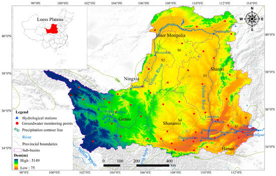
Figure 1.
Location of the research areas and hydrological stations, as well as the division of sub-watersheds. S1–S6 represents the number of each sub-basin.
2.2. Data Sources and Collection
2.2.1. Precipitation and Runoff
The precipitation data were mainly collected from the National Tibetan Plateau Data Center (https://data.tpdc.ac.cn/zh-hans/data/faae7605-a0f2-4d18-b28f-5cee413766a2 accessed on 16 April 2023). Delta spatial downscaling was used to obtain data from the 30′ Climatic Research Unit (CRU) time series dataset [27], and the downscaled data have a resolution of 1 km. It was evident that the downscaled dataset exhibited smaller deviations than the original CRU dataset. To assess the accuracy of the downscaling results, the observed long-term precipitation variables of 496 national weather stations from 1951 to 2021 across China were collected from the National Meteorological Information Center of China (http://data.cma.cn/en accessed on 8 May 2022). The downscaled and observed data showed significant relevance and minor differences in spatiotemporal trends [27].
2.2.2. Evapotranspiration and Water Resources Consumption
The yearly evapotranspiration in the Loess Plateau during the 2001–2020 period was estimated using an ETWatch model with a resolution of 1 km. The monthly observed lysimeter data during the 2004–2008 period were collected to evaluate the accuracy of the ET values simulated by the ETWatch model. In addition, the model results were also compared with several other ET products, such as the GLDAS-Noah and PEW datasets. Overall, the evapotranspiration simulated by the ETWatch model was reliable. Detailed information can be found in the published article by Cao et al. (2023) [10]. The water consumption data were mainly collected from the water resource bulletins (WRBs) announced by provincial water resources departments during the period from 2001 to 2020. This study mainly collected water consumption data from Qinghai, Gansu, Ningxia, Inner Mongolia, Shananxi, Shanxi, and Henan, covering the study area.
2.2.3. CSR GRACE Mascon Solutions
This study collected monthly GRACE data, as officially released by the CSR at the University of Texas at Austin [28]. The mass concentration blocks (mascons) method was used to retrieve the TWSC data, based on the GRACE data. All the proper rectifications have been made for mascon solutions and no additional filtering was applied to the data, which ensures that the data are more accurate [29,30]. These datasets can be obtained from the website (http://www2.csr.utexas.edu/grace accessed on 8 August 2023). The RL05 solution and RL06 Mascon grids were offered at spatial resolutions of 0.5° × 0.5° and 0.25° × 0.25°, respectively. In order to ensure consistent spatial resolution, the RL05 data were resampled to a resolution of 0.25° × 0.25° on the basis of the arithmetic mean approach. The datasets obtained for this work covered the period from 2004 to 2017.
2.2.4. Land Surface Models
The land surface models mainly include the catchment land surface model (CLSM) and Noah model in the second version of the global land data assimilation system (GLDAS-2). The Noah model estimates the surface water storage covering canopy, snow, and soil moisture. The CLSM not only includes surface water and soil water but also groundwater storage. The GLDAS models can simulate the transfer of water from the soil to vegetation to the atmosphere, but without considering irrigated crops and human activities such as water use and reservoir management. The Noah model and CLSM dataset can be downloaded from the following website (https://disc.gsfc.nasa.gov/datasets accessed on 8 October 2023). The dataset has a spatial resolution of 0.25° × 0.25° and covers the period from 2004 to 2017.
2.3. Methods
2.3.1. Variation Trend Analysis
In order to analyze the changing temporal trends of hydrological cycle components, linear regression analysis, which is simple and effective, was selected for this study. Linear regression analysis can simulate the changing trends in each grid and comprehensively reflect regional pattern evolution by analyzing the spatial variation characteristics of individual pixels at different periods [31,32,33]. Its advantage is that the fitting of data from different time periods contributes to eliminating the influence of abnormal factors on variables. The following is the calculation formula:
where slope characterizes the trend and rate of change. If slope > 0, this indicates an upward trend of the variable over time. If slope < 0, this indicates a downward trend. n is the research period; Ci is the variable value for the ith year (such as precipitation, evapotranspiration, etc.).
The significance of the trend is tested using an F-test to assess the credibility of the changing trend. The formula is as follows:
where yi represents the pixel value of the ith year variable; represents the regression value; represents the average value of the variable during the study period; and n represents the number of years.
2.3.2. Water Balance Calculation and Evaluation
On the basis of DEM and river systems analysis, the study area was divided into 6 sub-basins, using a SWAT model for water balance estimation. The terrestrial water balance includes four key components: precipitation, evapotranspiration, runoff, and total water storage change, as displayed in Equation (3):
where TWSC is the total water storage change; P is the precipitation; Rin refers to the amount of runoff flowing into the study area; Rout refers to the amount of runoff flowing out of the study area; ETn is the evapotranspiration; Eh is the amount of anthropogenic water consumption in the process of transporting and using water.
To evaluate the calculation result, a comparison between the calculation result and 2 products including the GLDAS and GRACE datasets was made. Indicators such as Nash–Sutcliffe efficiency (NSE), root mean squared error (RMSE), and mean absolute error (MAE) were selected to quantify the difference between the calculation result and remote sensing data in time t [10]:
where QGRACE and modelt represents the values from remote sensing products and Qwater balancet represents the calculated value for time t. represents the average value of the remote sensing products.
2.4. Statistical Analysis
OriginPro 2019b (OriginLab Company, Northampton, MA, USA) was used as an effective tool for statistical analysis. A linear regression model was employed to evaluate the variation trends of the water balance components. ArcGIS 10.3 was employed to draw up the spatial maps of the water balance components.
3. Results
3.1. Spatio-Temporal Trends of Water Balance Components on the Loess Plateau
3.1.1. Precipitation
As a whole, precipitation displayed an increasing trend, from 413.89 mm in 2001 to 514.13 mm in 2020, and the annual average increase rate was 2.56 mm/yr. The precipitation in the S1 area presented a significant increase from 2001 to 2020 at the 0.05 level, with a coefficient of r = 0.4806 (Figure 2). The precipitation in several other sub-basins did not show significant changes, which was a result of the abnormal precipitation in 2003. Due to the impact of climate circulation systems, the long duration of precipitation during the flood season resulted in a higher average annual precipitation in 2003. Except for S5, the precipitation in other sub-basins showed a significant increasing trend from 2004 to 2020, with coefficients of 0.4706~0.5869 (Figure 2).
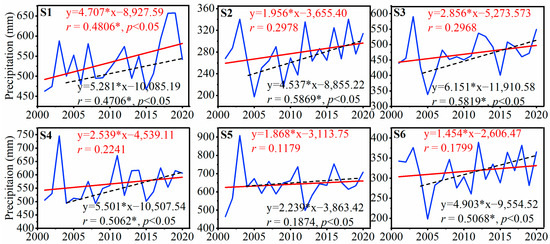
Figure 2.
Temporal trends of precipitation in each sub-basin and a significance test at the 0.05 level during the 2001–2020 period. S1–S6 represents the number of each sub-basin. * means the significance at the 0.05 level.
Spatially, the annual precipitation from 2001 to 2020 displayed a strip-shaped distribution (Figure 3e). The precipitation displayed an increasing trend from the north to the south of the Loess Plateau, with a low-value area in the north (0–200 mm) and a high-value area lying in the south (800–1000 mm). The area of precipitation in the ranges of 400–600 mm and 200–400 mm accounted for 45.49% and 30.99% of the whole region, respectively. The area of precipitation in the range of 0–200 mm displayed a shrinking trend, and the area of precipitation in the range of 600–800 mm displayed an expansion trend (Figure 3a–d). Due to the spatial difference in precipitation, variation trend analysis was carried out by applying the linear regression method. As is shown in Figure 3f, the annual precipitation in only 6.11% of the whole region from 2001 to 2020 showed sporadic distribution and downward trends, with a declining rate of −2~0 mm/year. The precipitation in 62.05% of the entire area had a changing rate of 0~2 mm/yr and that in 25.48% of the entire area had a changing rate of 2~4 mm/yr. They presented significant upward trends, particularly in the source regions of the Yellow River.
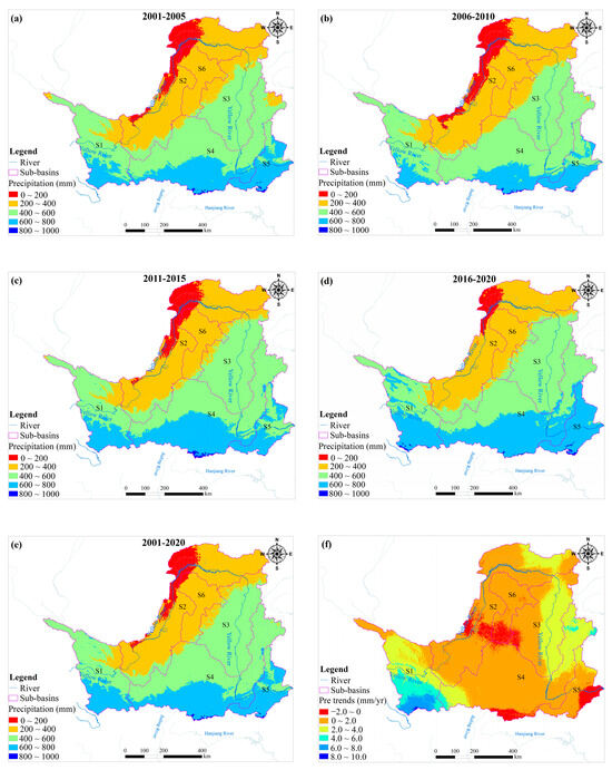
Figure 3.
(a–d) Spatial distributions of average precipitation during the periods of 2001–2005, 2006–2010, 2011–2015, and 2016–2020; (e) spatial distribution of average precipitation during the 2001–2020 period; (f) changing trends of precipitation during the 2001–2020 period.
3.1.2. Evapotranspiration
The mean ET in the Loess Plateau during the 2001–2020 period exhibited a fluctuating upward trend from 380.61 mm in 2001 to 500.16 mm in 2020, with an increasing rate of 5.27 mm/yr. To distinguish the significance of ET change, a t-test was used (p < 0.05) and the results are given in Figure 4. As is shown in Figure 4, the average ET displayed a significant upward trend with an increasing rate of 3.23~9.85 mm/yr in the S1, S2, S3, S4, and S6 areas during the 2001–2020 period, and the mean ET in the S5 area did not present a significant increasing trend. Previous studies also evaluated ET variations and concluded that there were similar trends in the Loess Plateau. Gao et al. (2020) estimated the annual ET in the Loess Plateau and found that the ET increased significantly during the 1990–2015 period, with an increasing rate of 1.7 mm/yr [26]. Ma et al. (2019) also concluded that continuous vegetation restoration resulted in a significant growth of ET, with an increasing rate of 2.07 mm/yr (p < 0.05) [34].
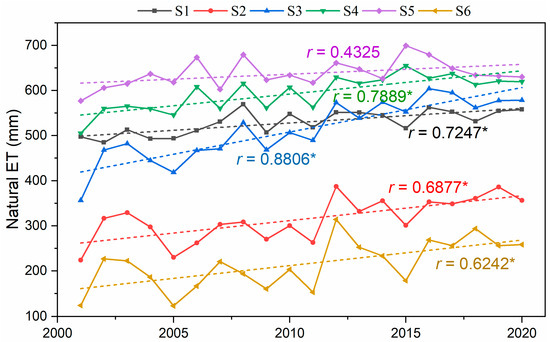
Figure 4.
Temporal trends of natural ET in each sub-basin during the 2001–2020 period. S1–S6 represents the number of each sub-basin. * means the significance at the 0.05 level.
We computed the ET values in the Loess Plateau at the four stages, including the 2001–2005, 2006–2010, 2011–2015, and 2016–2020 periods (Figure 5a–d). The annual mean values of ET in the whole region were 428.72 mm (2001–2005), 461.47 mm (2006–2010), 492.92 mm (2011–2015), and 515.64 mm (2016–2020), which exhibited an upward trend. As shown in Figure 5a–d, the area proportion of ET in the range of 600~800 mm was also extremely enlarged, from 17.82% in the first stage to 38.49% in the fourth stage. Related studies also indicated that regional ET was displaying an increasing trend and the area with a high ET value also showed an upward trend [26]. Spatially, ET exhibited an increasing trend from northwest to southeast (Figure 5e), which was similar to the spatial distribution pattern of vegetation coverage on the Loess Plateau. Related studies also suggested that the type and structure of the vegetation may have a significant impact on ET [35].
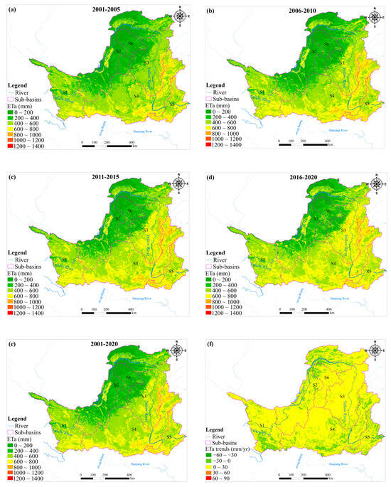
Figure 5.
(a–d) Spatial distributions of the average ETa during the periods of 2001–2005, 2006–2010, 2011–2015, and 2016–2020; (e) spatial distribution of the average ETa during the 2001–2020 period; (f) changing trends of ETa during the 2001–2020 period.
In considering the spatial heterogeneity in the Loess Plateau affected by land use/cover change and climate change, we also conducted a trend analysis during the 2001–2020 period (Figure 5f). The annual variation rates of ET in the ranges of −30~0 mm/yr and 0~30 mm/yr accounted for 10.73% and 89.12%, respectively. The results indicated that the ET displayed an upward trend in most areas of the Loess Plateau. The upward areas are mainly situated in the croplands and forested land of the central and southern parts of the Loess Plateau. Moreover, the decreasing areas are primarily situated in the northeast, and cultivated land is the predominant land-use type in these areas [34].
3.1.3. Surface Runoff
The annual average runoff exhibited a fluctuating and significantly upward trend during the 2000–2022 period (p < 0.05), with a variation rate of 3.92 × 10⁸ m3/yr (Figure 6). The changing trend of runoff was consistent with precipitation. The mutation points were identified as 2012, 2016, and 2020. As is shown in Figure 6, a significant upward trend was observed during the 2000–2012 period (p < 0.05), with a variation rate of 5.26 × 10⁸ m3/yr. In addition, a significant decreasing trend was detected during the 2012–2016 period (p < 0.05), with a variation rate of −21.89 × 10⁸ m3/yr. Again, a significant upward trend was discovered during the 2016–2020 period (p < 0.05), with a variation rate of 38.47 × 10⁸ m3/yr. A significant decreasing trend was found for 2020–2022 (p < 0.05), with a variation rate of −41.83 × 10⁸ m3/yr. Similar changing trends were also found in each sub-basin. The variation rates of S1, S2, S3, S4, and S5 were 2.02, 7.07, 5.91, 2.34, and 3.42 × 10⁸ m3/yr during the 2000–2022 period, respectively. Spatially, the annual average runoffs were relatively large in the S2 and S3 areas located in the middle reach of the Yellow River, with ranges of 187.10~453.81 × 10⁸ m3 and 139.60~380.00 × 10⁸ m3, respectively. The runoff was mainly affected by a combination of factors such as climate variability and human disturbances such as returning farmland to forest and grassland, the construction of check dams, and other soil and water conservation measures [36].
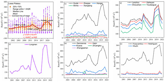
Figure 6.
Temporal trends of surface runoff in each sub-basin during the 2000–2022 period. S1–S5 represents the number of each sub-basin. * means the significance at the 0.05 level.
3.1.4. Water Resource Consumption
The human use of water resources has an important effect on changes in terrestrial water balance, particularly in regions with intense anthropogenic disturbance like the Loess Plateau. Anthropogenic water consumption was analyzed in the various sub-basins of the Loess Plateau (Figure 7). The annual mean water consumption was 3.81 × 10⁸ m3 in the S1 area located in the upper reach of the YRB and presented a significant decreasing trend with a downward rate of −0.06 × 10⁸ m3/yr during the 2001–2020 period (p < 0.05). The annual mean water consumption values were 8.75, 5.12, and 11.75 × 10⁸ m3 in the S2, S3, and S6 locations in the middle reach of the YRB, respectively, and water consumption in the S3 area displayed a significant upward trend, with an upward rate of 0.11 × 10⁸ m3/yr during the 2001–2020 period (p < 0.05). The annual mean water consumption values were 4.39 and 4.31 × 10⁸ m3 in the S4 and S5 locations in the lower reach of the YRB and displayed significant upward trends, with growth rates of 0.09 and 0.07 × 10⁸ m3/yr during the 2001–2020 period (p < 0.05), respectively.
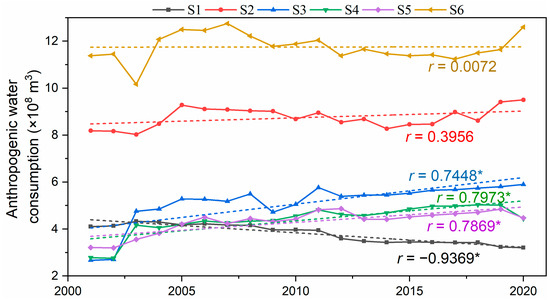
Figure 7.
Temporal trends of anthropogenic water consumption in each sub-basin during the 2001–2020 period. * means the significance at the 0.05 level.
Compared with the upstream sub-basins, the water consumption levels in the middle and downstream sub-basins were higher and exhibited significant increasing trends, with coefficients of 0.7448~0.7973 (p < 0.05). The upper reaches of the YRB are source areas that are well protected, such as by the implementation of water-saving irrigation measures, resulting in lower water resource consumption. In the middle and lower reaches of the region, the consumption of surface water and groundwater is mainly from agricultural irrigation, followed by consumption by industry, livestock, and residents. Related research also indicated that although groundwater consumption has shown a slight decrease, the records from the WRB indicated that total water consumption exhibited a steady increase from the upstream to the downstream regions [24].
3.2. Variations in the Terrestrial Water Balance
To characterize the water resource status in the Loess Plateau, we evaluated the dynamics of water balance (Figure 8a). When considering the multiple basins with various climate types and human activities, the TWSCwater balance values displayed various trends in each sub-basin. The TWSCwater balance values displayed decreasing trends and were close to 0 in the S2 and S6 areas, which suggested that the recharge and discharge of water resources in these regions tended to be in balanced states. The change rates of TWSCwater balance were −5.24 × 10⁸ m3/yr and −1.82 × 10⁸ m3/yr in the S2 and S6 areas, respectively. The TWSCwater balance did not display statistically significant trends in the S1, S4, and S5 areas, and the TWSCwater balance in the S3 area displayed a significant decreasing trend, with a change rate of −7.19 × 10⁸ m3/yr. As a whole, the recharge amount was less than the discharge amount in the Loess Plateau from 2001 to 2020, and the difference between recharge and discharge was gradually expanding, with a change rate of −3.72 × 10⁸ m3/yr. In order to further verify this trend, the TWSC values from the GRACE solutions and models were used to compare with the TWSC related to water balance. It could also be seen that the TWSCwater balance values of the whole basin were in the range of −113.08~100.52 × 10⁸ m3, and the TWSC values based on CSR RL05, CSR RL06, CLSM, and Noah models were in the ranges of −935.56~447.31 × 10⁸ m3, −874.42~560.76 × 10⁸ m3, −57.03~144.86 × 10⁸ m3 and −137.45~333.27 × 10⁸ m3, respectively (Figure 8a,b), which indicated that the TWSC related to water balance displayed certain differences from the TWSC values on the basis of the GRACE solution and model results. As is also shown in Figure 8b, the TWSCGRACE and model presented similar decreasing trends, although the TWSCGRACE and model values were not statistically significantly close to TWSCwater balance values (Figure 8c,d). The TWSC results from CLSM suggested that the recharge and discharge of water resources were basically in a balanced state during the 2004–2017 period, and the TWSC results from the Noah model displayed a large variation. The TWSC results from CSR RL05 and CSR RL06 indicated that water resources in this region displayed a transition from surplus to deficit during the 2004–2017 period.
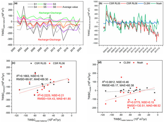
Figure 8.
(a) Temporal trends of TWSC from water balance in each sub-basin during the 2001–2020 period. (b) Temporal trends of TWSC on the basis of the GRACE and model results during the 2004–2017 period. (c) Comparisons between TWSC values from the water balance and GRACE solutions. (d) Comparisons between TWSC values from the water balance and models.
The terrestrial water balance exhibited spatial differences (Figure 9). The areas with a TWSC value of less than 0 cm/yr accounted for 16.25%, 85.32%, and 100% of the whole Loess Plateau balance in 2003, 2010, and 2015, respectively. However, compared to the past few years, the area with a TWSC value of less than 0 cm/yr has decreased in 2020, accounting for 62.25% of the whole Loess Plateau. It is possible that this decreasing trend is the result of the implementation of water-saving irrigation measures in Qinghai, Gansu, and Shananxi in recent years [15], which have led to water supply exceeding discharge in these regions. In addition, the TWSC displayed a gradually increasing trend from the eastern regions to the western regions of the Loess Plateau. This result indirectly indicated that compared to the western region, the TWSC in the eastern region was more strongly affected by human activities and climate change.
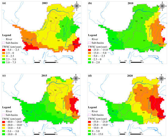
Figure 9.
Spatial distributions of average TWSC during the 2003–2020 period. (a) TWSC in 2003; (b) TWSC in 2010; (c) TWSC in 2015; (d) TWSC in 2020.
4. Discussion
4.1. Factors Affecting the Terrestrial Water Balance
Climate change and intensive anthropogenic disturbances are considered the major influencing factors of terrestrial water balance change. Climate variation mainly affects hydrological processes and water resource allocation by changing precipitation patterns and temperature, which further impact runoff depth, peak, and duration [14,37]. This research suggested that both runoff and precipitation show a similar positive trend. Related studies also indicated that runoff has a significant positive correlation with precipitation [38]. The upward trend of slope in this region stated clearly that precipitation was having a gradually strengthening impact on runoff, which may be the result of large-scale revegetation measures that diminish the effect of anthropogenic activities. In addition to its direct impact on runoff, precipitation also has an indirect impact by affecting evaporation. Along with a change in precipitation, other factors such as ET also underwent significant changes, leading to changes in runoff. ET is considered an important link in the water cycle, participating in surface water balance and transformation processes, as well as affecting energy balance processes [39]. It is an important parameter reflecting and influencing climate system changes. In general, precipitation is considered to play a positive role in ET variation, with a contribution of 9.30% [10]. Nevertheless, recent studies indicated that precipitation may restrain ET variations in some wet areas; the main reason for this is that higher air humidity reduces the migration of water from terrestrial ecosystems to the atmosphere [40]. Overall, runoff and ET change are complicated processes influenced by multiple factors, and they show evident regional differences. Although precipitation has a direct effect on runoff and ET, the relationships between them are complex due to the impact of some other factors. For instance, some previous works suggested that temperature also showed relatively high correlations with ET and runoff, with coefficients of 0.57~0.825 [10,37].
Compared to climate factors, terrestrial water balance is more strongly affected by human activities in the Loess Plateau, such as land use/cover changes and other human disturbances. Among these anthropogenic drivers, vegetation change has been found to be a crucial force resulting in changes in water balance components such as ET and runoff. Over the past few years, the land use/cover of the Loess Plateau has undergone significant changes on account of rapid urbanization and the implementation of ecological remediation measures, such as returning farmland to forests and grasslands [41]. It is expected that revegetation may have a significant influence on the terrestrial water balance by changing the various processes of water transfer and energy distribution, such as canopy transpiration and soil water infiltration [42]. Previous findings also revealed a noticeable interaction between water reserves and vegetation growth [43]. Land use/cover change was the primary driving force resulting in changes in runoff, with a contribution of 74.8% [37]. In contrast, it also promotes the evapotranspiration of soil moisture, with a contribution of 52.9% [10]. Actually, anthropogenic water consumption also has a significant influence on changes in terrestrial water balance, particularly in regions with intensive human disturbance like the Loess Plateau. Some studies suggested that coal mining could significantly lower groundwater levels and give rise to a dramatic reduction in the river’s base flow and total streamflow in the dry season [44]. Moreover, reservoir regulation, agricultural irrigation, water diversion, and coal transport could result in a reduction in streamflow and an increase in ET, influencing the terrestrial water balance [45].
Overall, it is evident that climatic and anthropogenic drivers affect ET and runoff and then drive changes in the terrestrial water balance. Along with the consecutive impact of climate variability and human disturbance, there are still some uncertainties in terrestrial water balance estimation in the future that may make water resources management difficult. In addition to changes to the underlying surface, anthropogenic water use was also an important driving force of changes in natural runoff and ET. Thus, future studies should focus on establishing the relationships between TWSC and domestic water, irrigation water, and reservoir regulation to explore the effect of anthropogenic pressures on TWSC.
4.2. Uncertainties and Limitations
In this study, there are multiple sources of uncertainty present. The complexity of the hydrological process inevitably leads to large uncertainties in water balance estimation. Besides this, the uncertainties of the data will also affect the results of water balance estimation. This work was mainly conducted on the basis of multi-source remote sensing data; however, these data have latent spatial and temporal inaccuracies that may influence the analysis results. The terrestrial water storage change data are at a spatial resolution of 0.25° × 0.25°, while the precipitation and ET data are at a spatial resolution of 0.5′ × 0.5′. Another limitation is that the temporal scales are not consistent. For instance, runoff and water resource consumption are given as yearly values, which accordingly results in yearly water balance estimation results. The present precipitation data were obtained by the delta spatial downscaling method, with certain deviations from the actual observation values, and more precipitation station data should be used in future work. At the same time, the ET values were mainly simulated using the ETWatch model, considering a large number of parameters; the inclusion of more parameters could eliminate the problem of biased sampling and reduce model uncertainty. While interactions may occur among more variables, there were two interactive variables in this study, which can cause a potential error. Thus, the accuracy of this model’s results needs further improvement based on multi-source data [10]. In addition, less in situ measured data for groundwater level, soil moisture, and ET in this region will lead to uncertainty of the results; thus, more observation stations should be deployed to ensure the spatiotemporal accuracy of terrestrial water balance calculations in the future. There are also some limitations in accurately obtaining the water withdrawal value of each sub-basin, based on the water withdrawal of each prefecture-level city in this region. In addition, local water diversion has not been considered, which may affect the water balance of each sub-basin. Overall, although the results have a certain uncertainty, this study can provide a basic approach for assessing the terrestrial water balance of the Loess Plateau, although the combination of remote sensing and in situ observation needs to be further strengthened in the future.
5. Conclusions
In this study, dynamic changes in the key hydrological cycle components and terrestrial water balance in the Loess Plateau were analyzed using remote sensing data. The results showed that precipitation and ET displayed similar spatiotemporal trends. Precipitation and ET exhibited increasing trends, from 413.89 mm and 380.61 mm in 2001 to 514.13 mm and 500.16 mm in 2020, with increasing rates of 2.56 mm/yr and 5.27 mm/yr, respectively. Spatially, the annual average precipitation and ET showed increasing trends from the north to south of the Loess Plateau from 2001 to 2020. The area of precipitation in the ranges of 400–600 mm and 200–400 mm accounted for 45.49% and 30.99% of the Loess Plateau precipitation, respectively. The change rate of ET in the range of 0~30 mm/yr accounted for 89.12%, which suggested that ET exhibited an upward trend in most areas of the Loess Plateau.
The annual average runoff showed a fluctuating and significantly upward trend during the 2000–2022 period, with a change rate of 3.92 × 10⁸ m3/yr. Runoff was relatively large in the middle reach of the Yellow River, with a range of 139.60~453.81 × 10⁸ m3. The annual average water consumption in the upper reach of the YRB presented a significant decreasing trend, with a downward rate of −0.06 × 10⁸ m3/yr for 2001–2020, yet it displayed a significant increasing trend in the middle and lower reaches of the YRB with an upward rate of 0.07~0.11 × 10⁸ m3/yr.
Overall, the recharge amount was less than the discharge amount in the Loess Plateau from 2001 to 2020, and the difference between recharge and discharge was gradually expanding, with a change rate of −3.72 × 10⁸ m3/yr. The TWSC displayed a gradually increasing trend from the eastern regions to the western regions of the Loess Plateau, which suggested that the eastern region was in an imbalanced state, while the western region was in a relatively balanced state. Climate change and intensive human disturbances were thought to be the predominant driving forces of terrestrial water balance change, and the impact of land-use/cover change was relatively significant. With the growth of socio-economic water use, the relationship between the supply and demand of regional water resources will further deteriorate. The rational utilization and scientific regulation of water resources should be the current primary goals. This study can provide theoretical support for the scientific management and sustainable utilization of water resources in the Loess Plateau.
Author Contributions
X.C. developed the concept and methodology. D.L. performed the data analysis, as well as took the lead in writing the manuscript. Y.Z., J.G., W.L. and K.K. participated in the revision of the manuscript. All authors have read and agreed to the published version of the manuscript.
Funding
This research was funded by the China Geological Survey (20230006-06, DD202217499) and the key project supported by the National Natural Science Foundation of China (grant no. U21A20155).
Data Availability Statement
The data presented in this study are available within the article.
Acknowledgments
The authors are very grateful to all anonymous reviewers, chief editors, and associate editors for their valuable comments and suggestions, which improved the quality of this paper.
Conflicts of Interest
The authors declare no conflicts of interest.
References
- Mengistu, D.; Woldeamlak Bewket, W.; Dosio, A.; Panitz, H.J. Climate change impacts on water resources in the Upper Blue Nile (Abay) River Basin. Ethiopia. J. Hydrol. 2021, 592, 125614. [Google Scholar] [CrossRef]
- Reichert, J.M.; Rodrigues, M.F.; Peláez, J.J.Z.; Lanza, R.; Minella, J.P.G.; Arnold, J.G.; Cavalcante, R.B.L. Water balance in paired watersheds with eucalyptus and degraded grassland in Pampa biome. Agric. For. Meteorol. 2017, 237–238, 282–295. [Google Scholar] [CrossRef]
- Sahoo, A.K.; Pan, M.; Troy, T.J.; Vinukollu, R.K.; Sheffield, J.; Wood, E.F. Reconciling the global terrestrial water budget using satellite remote sensing. Remote Sens. Environ. 2011, 115, 1850–1865. [Google Scholar] [CrossRef]
- Sheffield, J.; Ferguson, C.R.; Troy, T.J.; Wood, E.F.; McCabe, M.F. Closing the terrestrial water budget from satellite remote sensing. Geophys. Res. Lett. 2009, 36, L07403. [Google Scholar] [CrossRef]
- Gao, H.; Tang, Q.; Ferguson, C.R.; Wood, E.F.; Lettenmaier, D.P. Estimating the water budget of major US river basins via remote sensing. Int. J. Remote Sens. 2010, 31, 3955–3978. [Google Scholar] [CrossRef]
- Adriana, A.M.; Anderson, L.R.; Débora, R.R.; de Arruda Souza, V.; da Rocha, H.R.; de Paiva, R.C.D. Assessment of terrestrial water balance using remote sensing data in South America. J. Hydrol. 2019, 575, 131–147. [Google Scholar]
- Pan, M.; Sahoo, A.K.; Troy, T.J.; Vinukollu, R.K.; Sheffield, J.; Wood, A.E.F. Multisource estimation of long-term terrestrial water budget for major global river basins. J. Clim. 2012, 25, 3191–3206. [Google Scholar] [CrossRef]
- Zhang, Y.; Pan, M.; Sheffield, J.; Siemann, A.L.; Fisher, C.K.; Liang, M.; Beck, H.; Wanders, N.; MacCracken, R.F.; Houser, P.R.; et al. A Climate Data Record (CDR) for the global terrestrial water budget: 1984–2010. Hydrol. Earth Syst. Sci. 2018, 22, 241–263. [Google Scholar] [CrossRef]
- Beck, H.E.; Pan, M.; Roy, T.; Weedon, G.P.; Pappenberger, F.; van Dijk, A.I.J.M.; Huffman, G.J.; Adler, R.F.; Wood, E.F. Daily evaluation of 26 precipitation datasets using Stage-IV gauge-radar data for the CONUS. Hydrol. Earth Syst. Sci. 2019, 23, 207–224. [Google Scholar] [CrossRef]
- Cao, X.H.; Zheng, Y.J.; Lei, Q.L.; Li, W.P.; Song, S.; Wang, C.C.; Liu, Y.; Kifayatullah, K. Increasing actual evapotranspiration on the Loess Plateau of China: An insight from anthropologic activities and climate change. Ecol. Indic. 2023, 157, 111235. [Google Scholar] [CrossRef]
- Guerschman, J.P.; McVicar, T.R.; Vleeshower, J.; Van Niel, T.G.; Peña-Arancibia, J.L.; Chen, Y. Estimating actual evapotranspiration at field-to-continent scales by calibrating the CMRSET algorithm with MODIS, VIIRS, Landsat and Sentinel-2 data. J. Hydrol. 2022, 605, 127318. [Google Scholar] [CrossRef]
- Martens, B.; Gonzale-Miralles, D.; Lievens, H.; Van Der Schalie, R.; De Jeu, R.A.; Fern´andez-Prieto, D. GLEAMv3: Satellite-based land evaporation and rootzone soil moisture. Geosci. Model Dev. 2017, 10, 1903–1925. [Google Scholar] [CrossRef]
- Doll, P.; Mueller Schmied, H.; Schuh, C.; Portmann, F.T.; Eicker, A. Global-scale assessment of groundwater depletion and related groundwater abstractions: Combining hydrological modeling with information from well observations and GRACE satellites. Water Resour. Res. 2014, 50, 5698–5720. [Google Scholar] [CrossRef]
- Hu, B.Y.; Wang, L.; Li, X.P.; Zhou, J.; Pan, Y. Divergent changes in terrestrial water storage across global arid and humid basins. Geophys. Res. Lett. 2021, 48, e2020GL091069. [Google Scholar] [CrossRef]
- Li, C.; Yu, Q.; Zhang, Y.; Ma, N.; Tian, J.; Zhang, X. Dominant drivers for terrestrial water storage changes are different in northern and southern China. J. Geophys. Res. Atmos. 2023, 128, e2022JD038074. [Google Scholar] [CrossRef]
- Oliveira, P.T.S.; Nearing, M.A.; Moran, M.S.; Goodrich, D.C.; Wendland, E.; Gupta, H.V. Trends in water balance components across the Brazilian Cerrado. Water Resour. Res. 2014, 50, 7100–7114. [Google Scholar] [CrossRef]
- Azarderakhsh, M.; Rossow, W.B.; Papa, F.; Norouzi, H.; Khanbilvardi, R. Diagnosing water variations within the Amazon basin using satellite data. J. Geophys. Res. Atmos. 2011, 116, D24107. [Google Scholar] [CrossRef]
- Penatti, N.C.; de Almeida, T.I.R.; Ferreira, L.G.; Arantes, A.E.; Coe, M.T. Satellitebased hydrological dynamics of the world’s largest continuous wetland. Remote Sens. Environ. 2015, 170, 1–13. [Google Scholar] [CrossRef]
- Mccabe, M.F.; Wood, E.F.; Wojcik, R.; Pan, M.; Sheffield, J.; Gao, H.; Su, H. Hydrological consistency using multi-sensor remote sensing data for water and energy cycle studies. Remote Sens. Environ. 2008, 112, 430–444. [Google Scholar] [CrossRef]
- Sun, W.; Jin, Y.; Yu, J.; Wang, G.; Xue, B.; Zhao, Y.; Fu, Y.; Shrestha, S. Integrating Satellite Observations and Human Water Use Data to Estimate Changes in Key Components of Terrestrial Water Storage in a Semi-Arid Region of North China. Sci. Total Environ. 2020, 698, 134171. [Google Scholar] [CrossRef] [PubMed]
- Lv, M.; Ma, Z.; Li, M.; Zheng, Z. Quantitative Analysis of Terrestrial Water Storage Changes Under the Grain for Green Program in the Yellow River Basin. J. Geophys. Res. Atmos. 2019, 124, 1336–1351. [Google Scholar] [CrossRef]
- Li, C.; Zhang, Y.; Shen, Y.; Yu, Q. Decadal Water Storage Decrease Driven by Vegetation Changes in the Yellow River Basin. Sci. Bull. 2020, 65, 1859–1861. [Google Scholar] [CrossRef] [PubMed]
- Xie, J.; Xu, Y.-P.; Wang, Y.; Gu, H.; Wang, F.; Pan, S. Influences of Climatic Variability and Human Activities on Terrestrial Water Storage Variations across the Yellow River Basin in the Recent Decade. J. Hydrol. 2019, 579, 124218. [Google Scholar] [CrossRef]
- Jing, W.; Yao, L.; Zhao, X.; Zhang, P.; Liu, Y.; Xia, X. Understanding terrestrial water storage declining trends in the Yellow River Basin. J. Geophys. Res. Atmos. 2019, 124, 12963–12984. [Google Scholar] [CrossRef]
- Fu, B.J.; Wang, S.; Liu, Y.; Liu, J.B.; Liang, W.; Miao, C.Y. Hydrogeomorphic ecosystem responses to natural and anthropogenic changes in the Loess Plateau of China. Annu. Rev. Earth Planet. Sci. 2017, 45, 223–243. [Google Scholar] [CrossRef]
- Gao, X.R.; Sun, M.; Luan, Q.; Zhao, X.N.; Wang, J.C.; He, G.H.; Zhao, Y. The spatial and temporal evolution of the actual evapotranspiration based on the remote sensing method in the Loess Plateau. Sci. Total Environ. 2020, 708, 135111. [Google Scholar] [CrossRef] [PubMed]
- Peng, S.Z.; Ding, Y.X.; Liu, W.Z.; Li, Z. 1 km monthly temperature and precipitation dataset for China from 1901 to 2017. Earth Syst. Sci. Data 2019, 11, 1931–1946. [Google Scholar] [CrossRef]
- Swenson, S.C. GRACE Monthly Land Water Mass Grids NETCDF RELEASE 5.0; The Physical Oceanography Distributed Active Archive Center (PO.DAAC): Pasadena, CA, USA, 2012. [Google Scholar]
- Save, H.; Bettadpur, S.; Tapley, B.D. High-resolution CSR GRACE RL05 mascons. J. Geophys. Res. Solid Earth 2016, 121, 7547–7569. [Google Scholar] [CrossRef]
- Scanlon, B.R.; Zhang, Z.; Save, H.; Wiese, D.N.; Landerer, F.W.; Long, D. Global evaluation of new GRACE mascon products for hydrologic applications. Water Resour. Res. 2016, 52, 9412–9429. [Google Scholar] [CrossRef]
- Zheng, Z.; Yang, Z.; Chen, Y.; Wu, Z.; Marinello, F. The Interannual Calibration and Global Nighttime Light Fluctuation Assessment Based on Pixel-Level Linear Regression Analysis. Remote Sens. 2019, 11, 2185. [Google Scholar] [CrossRef]
- Wang, L.; Li, W.; Zheng, Y.; Zhang, X.; Yuan, F.; Wu, X. Water Deficit Caused by Land Use Changes and Its Implications on the Ecological Protection of the Endorheic Dalinor Lake Watershed in Inner Mongolia, China. Water 2023, 15, 2882. [Google Scholar] [CrossRef]
- Yagbasan, O.; Demir, V.; Yazicigil, H. Trend Analyses of Meteorological Variables and Lake Levels for Two Shallow Lakes in Central Turkey. Water 2020, 12, 414. [Google Scholar] [CrossRef]
- Ma, Z.H.; Yan, N.N.; Wu, B.F.; Stein, A.; Zhu, W.W.; Zeng, H.W. Variation in actual evapotranspiration following changes in climate and vegetation cover during an ecological restoration period (2000–2015) in the Loess Plateau, China. Sci. Total Environ. 2019, 689, 534–545. [Google Scholar] [CrossRef] [PubMed]
- Liu, S.; Niu, X.; Wang, B.; Song, X.; Tao, Y. An ecological benefit assessment of the Grain for Green Project in Shannxi Province. Acta Ecol. Sin. 2018, 38, 5759–5770. (In Chinese) [Google Scholar]
- Li, Z.H.; Wang, Y.M.; Zhang, H.B.; Chang, J.X.; Yu, Y.H. Runoff response to changing environment in Loess Plateau, China: Implications of the influence of climate, land use/land cover, and water withdrawal changes. J. Hydrol. 2022, 613, 128458. [Google Scholar] [CrossRef]
- Bibi, S.; Wang, L.; Li, X.; Zhang, X.; Chen, D. Response of groundwater storage and recharge in the Qaidam Basin (Tibetan Plateau) to climate variations from 2002 to 2016. J. Geophys. Res. Atmos. 2019, 124, 9918–9934. [Google Scholar] [CrossRef]
- Bai, X.L.; Zhao, W.Z. Impacts of climate change and anthropogenic stressors on runoff variations in major river basins in China since 1950. Sci. Total Environ. 2023, 898, 165349. [Google Scholar] [CrossRef]
- Pan, Y.; Zhang, C.; Gong, H.; Yeh Pat, J.-F.; Shen, Y.; Guo, Y. Detection of human-induced evapotranspiration using GRACE satellite observations in the Haihe River basin of China. Geophys. Res. Lett. 2017, 44, 190–199. [Google Scholar] [CrossRef]
- Feng, S.Y.; Liu, J.Y.; Zhang, Q.; Zhang, Y.Q.; Vijay, P.S.; Peng, S. A global quantitation of factors affecting evapotranspiration variability. J. Hydrol. 2020, 584, 124688. [Google Scholar] [CrossRef]
- Wang, S.; Fu, B.J.; Piao, S. Reduced sediment transport in the Yellow River due to anthropogenic changes. Nat. Geosci. 2015, 9, 38–41. [Google Scholar] [CrossRef]
- Xie, X.H.; Cui, Y.L. Development and test of SWAT for modeling hydrological processes in irrigation districts with paddy rice. J. Hydrol. 2011, 396, 61–71. [Google Scholar] [CrossRef]
- Velicogna, I.; Kimball, J.S.; Kim, Y. Impact of changes in GRACE derived terrestrial water storage on vegetation growth in Eurasia. Environ. Res. Lett. 2015, 10, 124024. [Google Scholar]
- Luan, J.K.; Miao, P.; Tian, X.Q.; Li, X.J.; Ma, N.; Faiz, M.A. Estimating hydrological consequences of vegetation greening. J. Hydrol. 2022, 611, 128018. [Google Scholar] [CrossRef]
- Tang, Q.H.; Zhang, X.J.; Tang, Y. Anthropogenic impacts on mass change in North China. Geophys. Res. Lett. 2013, 40, 3924–3928. [Google Scholar] [CrossRef]
Disclaimer/Publisher’s Note: The statements, opinions and data contained in all publications are solely those of the individual author(s) and contributor(s) and not of MDPI and/or the editor(s). MDPI and/or the editor(s) disclaim responsibility for any injury to people or property resulting from any ideas, methods, instructions or products referred to in the content. |
© 2024 by the authors. Licensee MDPI, Basel, Switzerland. This article is an open access article distributed under the terms and conditions of the Creative Commons Attribution (CC BY) license (https://creativecommons.org/licenses/by/4.0/).