Article

Distribution and Ecological Risk Assessment of Nutrients and Heavy Metals in the Coastal Zone of Yantai, China

1
Yantai Center of Coastal Zone Geological Survey, China Geological Survey, Yantai 264004, China
2
Shandong Key Laboratory of Water Pollution Control and Resource Reuse, School of Environmental Science and Engineering, Shandong University, Qingdao 266237, China
*
Authors to whom correspondence should be addressed.
Water 2024, 16(5), 760; https://doi.org/10.3390/w16050760
Submission received: 15 January 2024 / Revised: 21 February 2024 / Accepted: 24 February 2024 / Published: 2 March 2024

Abstract

:
As urbanization accelerates, a growing influx of pollutants enters the sea through land runoff, posing a threat to coastal ecosystems. In this study, we systematically determined the concentrations of nutrients and heavy metals in the water and sediments of coastal areas (Yantai, China) and assessed their sources and ecological risks. The results showed that inland rivers transported large amounts of NO3 and PO43− into coast water, which caused severe eutrophication. Regarding heavy metals, copper dominated in seawater, whereas plumbum and arsenic were dominant in sediment, which was sourced from aerosol deposition and mariculture. Zinc, chromium, copper, mercury, and cadmium contributed slightly to pollution, with low enrichment factors, mainly from natural sources. Further analysis showed that zinc, mercury, copper, and arsenic were significantly affected by the grain size composition in sediment. Ecological risk assessment indicated that the coastal zone of Yantai City is in a state of light heavy-metal pollution.

1. Introduction

As areas where the exchange of matter and energy occurs between the ocean and land, coastal zones are home to some of the most biogeochemically diverse systems on Earth, supporting numerous ecosystem services [1]. With the acceleration of urbanization, an increasing number of pollutants are being produced and discharged into the environment. Pollutants entering surface water eventually converge with rivers and enter the sea [2]. The ongoing impacts of human activities threaten coastal ecosystems, reducing the richness and diversity of the biome and, over time, leading to the loss of coastal ecosystem services and economic opportunities [3]. Among the numerous forms of pollution, eutrophication and heavy-metal pollution are two important and common factors in coastal areas widely studied in various coastal countries.
Eutrophication involves an increase in nutrients, such as nitrogen and phosphorus, in coastal seawater, causing phytoplankton to multiply and eventually leading to red tides [4,5]. In such environments, atmospheric reoxygenation of surface seawater is blocked, which reduces the dissolved oxygen content in sediments and seawater, resulting in the death of marine organisms due to hypoxia, producing odors, and increasing the turbidity of seawater [6]. These environmental problems affect the marine ecological balance. Furthermore, toxins produced by planktonic algae accumulate in marine aquatic products through the food chain, affecting human health [7]. According to a recent study by Dai et al. (2003) to 2020, the spatial extent of coastal red tide outbreaks worldwide has increased by 13.2%, and their frequency has increased by 59.2% [8]. Hence, given the rising occurrence of severe coastal red tide outbreaks, it is imperative to prioritize and enhance investigations and monitoring of nutrient discharges in critical areas.
Heavy metals are considered one of the most important pollutants in coastal aquatic ecosystems and are characterized by high toxicity, environmental persistence, difficult biodegradation, and bioaccumulation [9,10]. Sediments are the main carriers of heavy metals in coastal environments and are prone to adherence to fine-grained sediments [11,12]. However, sediment is also a habitat for microorganisms, and benthos at the bottom of the biological chain [13], and the toxicity of heavy metals is gradually amplified through the food chain, posing a serious threat to human health [14]. Sediments are the “sink” of heavy metals in seawater and the “source”. Heavy metals adsorbed on sediments are re-released into seawater, with changes in the hydrodynamic conditions and sedimentary environment causing secondary pollution [15,16]. Estuaries and coastal waters, which are closely affected by human activities, are polluted to varying degrees [17]. Therefore, identifying the spatial distribution and main sources of heavy metals in seawater and sediments in densely populated coastal zones and assessing the potential ecological risks of heavy metals are crucial for planning coastal space utilization and providing environmental management suggestions.
Yantai City is located on the southern coast of the Yellow Sea in China, where industrial, agricultural, fishing, tourism, mining, and other activities have been integrated for decades. The long coastline provides Yantai with an opportunity to develop marine activities; however, it also inevitably releases pollutants into the water. Agricultural activities, industrial wastewater discharge, and atmospheric aerosol deposition continue to transport pollutants from inland into the ocean [3]. Nutrients and heavy metals from marine economic activities and inland transport pose the risk of environmental pollution and ecological damage to the Yantai coastal zone. Additionally, the southern part of the Yellow Sea is a partially closed coastal shelf sea, and its limited diffusion capacity may have led to the coastal waters of Yantai accumulating more pollutants discharged inland. There existed few available data on the assessment of eutrophication and heavy-metal pollution in the coastal zone of Yantai, and the potential ecological risks caused by them remain unclear.
This study collected seawater and sediments from the coastal waters of Yantai City and water samples from two rivers that flow into the sea to assess eutrophication and heavy-metal pollution in the Yantai coastal zone. The purpose of this study was to (I) clarify the degree of eutrophication of coastal seawater in Yantai City and evaluate the influence of nutrients imported from rivers into the sea on coastal eutrophication, and (II) illustrate the occurrence, distribution, and potential ecological risk of heavy metals in sediments. This study provides a reference for preventing and treating coastal eutrophication and heavy-metal pollution in coastal cities.

2. Materials and Methods

2.1. Sampling Site Layout and Sample Collection

The investigation area of this study includes the coastal zones of four main administrative districts in Yantai where human activities are the most concentrated—the Economic and Technological Development Zone and the Zhifu, Laishan, and Muping Districts (37°04′–37°43′ N, 121°42′–121°55′ E). The entire survey area has a temperate monsoon climate. The two rivers that flow into the sea, the Jiahe River and the Qinshui River that are involved in this study are located in the Economic and Technological Development Zone and Muping District, respectively. Wang et al. (2016) proved that domestic sewage, industrial wastewater, aquaculture wastewater, and agricultural wastewater were discharged into the sea in the coastal areas of Yantai. At the same time, Yantai is an important fertilizer-producing area in China, and the mass production and use of fertilizer also is concerning [18]. We established 30 sampling sites along the coast of the four main administrative regions. These sampling sites were categorized based on their specific locations within each region, and the classification results can be found in Table S1. In addition, 29 sampling sites were established on the Jiahe River, and six sampling sites were established on the Qinshui River (Figure 1). In August 2022, we conducted a sample collection. Two water samples were collected; one of them was collected directly, and the other one was filtered with a 0.45 µm filter membrane immediately after collection. The water samples were placed in brown glass bottles and acidified with sulfuric acid to pH < 2. A grab bucket sampler was used for sampling. We collected 0–3 cm of surface sediment using a wooden spoon and placed it in a polyethylene plastic bag. Water and sediment samples were stored at 4 °C immediately after sampling and brought to the laboratory on the day of sampling.

2.2. Water Sample Characterization

Water samples not filtered by a 0.45 µm filter membrane were used for the determination of the heavy metal, and nutrients were determined using the filtered water samples. All tests were performed according to the standard testing methods of the Chinese national standard. Nitrate (NO3) and nitrite (NO2) were detected using ion chromatography; PO43− was measured using ammonium molybdate spectrophotometry, and chemical oxygen demand (COD) was measured using the alkaline potassium permanganate method. The total amount of Pb, Zn, Cu, Cr, and Cd was determined by inductively coupled plasma emission spectrometry. A proper amount of nitric acid was added immediately after sample collection to make the nitric acid content reach 1%. We sent the samples to the laboratory for testing. The first step of detection was to digest the sample. A 100 mL sample was taken, and 5.0 mL of 50% concentration nitric acid solution was added to it. Then, it was put on an electric heating plate for heated digestion and slowly heated until it was nearly dry without boiling. Next, remove the sample and let it cool. Repeat this process until the color of the sample solution becomes lighter or more stable. After cooling, add a few milliliters of 50% nitric acid and a small amount of water in turn, and continue heating on the electric heating plate to dissolve the residue. Wait for the sample to cool, and fill it with deionized water to the original sample volume so that the solution maintains 1% (v/v) nitric acid acidity. Measure the emission intensity of the sample to obtain the content of the target element from the emission intensity value on the calibration curve. In the process of sample measurement, if the concentration of elements to be measured in the sample exceeds the range of the calibration curve, the sample should be diluted and re-determined. The total amount of Hg is determined using the atomic fluorescence method. After collecting the river sample, add hydrochloric acid at the ratio of 5 mL of high-grade pure hydrochloric acid per liter of the water sample, and add hydrochloric acid to the seawater sample to the same pH as the river sample. Send the samples to the laboratory for testing. The 5.0 mL sample is put into a 10 mL colorimetric tube, and 1 mL hydrochloric-nitric acid solution is added. Heat and digest the solution in a water bath of boiling water for 1 h, during which time shake the colorimetric tube once or twice and open the lid to deflate. Wait for the sample to cool, and fill it with water to mark the line of the colorimetric tube. After mixing well, Measure the atomic fluorescence intensity. Obtain the content of Hg by querying the calibration curve. If the sample exceeds the high concentration point of the calibration curve, dilute the digestion solution and then determine.

2.3. Sediment Sample Characterization

The heavy metal content of the sediments was measured according to the Method for Chemical Analysis of Submarine Sediments [19]. Specific methods and procedures to determine the heavy metal content and grain size composition in sediments have been described in previous studies [20]. The total organic carbon (TOC) content of the sediment was determined with a non-dispersive infrared absorption method using a carbon-sulfur meter. The TFe2O3 content was determined using wavelength-dispersive X-ray fluorescence spectrometry to calculate the Fe content in the sediments.

2.4. Pollution Assessment

2.4.1. Evaluation of Eutrophication

The eutrophication index (Ei) was used to assess the eutrophication degree of water. Eutrophication is defined in three degrees: mild eutrophication (1 ≤ Ei ≤ 3), moderate eutrophication (3 < Ei ≤ 9), and severe eutrophication (Ei > 9). Ei is calculated based on Equation (1) [21].
E i = C C O D × C C I N × C C I P 4500 × 10 6
where Ei is the eutrophication index, COD, DIN, and DIP represent the chemical oxygen demand, dissolved nitrogen (the sum of ammonia nitrogen (NH4+), nitrate nitrogen (NO3), and nitrous nitrogen (NO2)), and dissolved phosphorus (phosphate (PO43−)), respectively. Furthermore, CCOD, CDIN, and CDIP are the COD, DIN, and DIP concentrations (mg/L), respectively.

2.4.2. Heavy Metal Enrichment Factor (EF)

The EF of heavy metals in sediments was calculated to evaluate the degree of heavy metal enrichment. Fe was used as the reference element in this study. The degree of heavy metal pollution in sediments was determined as follows: EF < 1, unpolluted; EF = 1–3, mildly polluted; EF = 3–5, moderately polluted; EF = 5–10, moderately to severely polluted; EF = 10–25, severely polluted; EF = 25–50, very heavily polluted; and EF > 50, extremely heavily polluted. The EF was calculated as follows [22]:
E F = C i / F e i C b / F e b
where EF is the enrichment factor, Ci is the measured value of element i in the sample, Fei is the measured value of element i in the sample, Cb is the reference value of element i, and Feb represents the reference value of Fe. The reference values of each element in this study were selected from the soil geochemical background values of Yantai City determined by Pang et al. [23]: Zn = 60.4, Pb = 27.2, Cr = 57, Hg = 0.034, Cu = 26, As = 6.4, Fe = 2.814 μg/g.

2.4.3. Assessment of Potential Ecological Risk of Heavy Metals

The potential ecological risk of heavy metals in sediments was assessed using the method proposed in a previous study [24]. The method includes the potential ecological risk index of a single heavy metal ( E r i ) and the comprehensive potential ecological risk index (ERI). The calculation formulas are given by Equations (3) and (4). According to E r i , the potential ecological risks of different heavy metals can be determined: E r i < 40, low risk; 40 ≤ E r i < 80, medium risk; 80 ≤ E r i < 160, considerable risk; E r i ≥ 160, high risk. ERI is an indicator to comprehensively evaluate the potential ecological risks caused by multiple heavy metal pollution in a region, and its potential ecological risk grade is divided according to ERI < 150, low risk; 150 ≤ ERI < 300, medium risk; 300 ≤ ERI < 600, considerable risk; ERI ≥ 600, high risk.
E r i = T r i × C f i = T r i × C i C n i
E R I = E r i
where E r i is the potential ERI of heavy metal i, T r i is the coefficient of toxicity response of heavy metal i, Ci is the measured content value of heavy metal i, C n i is the reference content value of heavy metal i, and ERI is the comprehensive potential ERI for the study site. According to the standardized heavy metal toxicity coefficient formulated by Hakanson, the T r i of each heavy metal was Zn = 1, Cu = 5, Pb = 5, Cr = 2, Hg = 40, and As = 10.

2.5. Statistical Analysis

SPSS 25.0 software (SPSS Inc., Chicago, IL, USA) was used for the statistical analysis, and the analyzed items include hierarchical cluster analysis, principal component analysis, and the correlation and significance difference of experimental data [25,26]. Pearson correlation coefficient was chosen for the type of correlation analysis. The t-test was used to evaluate the statistically significant difference. When the p-value is lower than 0.05, the difference between the data is considered significant.

3. Results and Discussion

3.1. Occurrence, Distribution and Evaluation of Nutrients

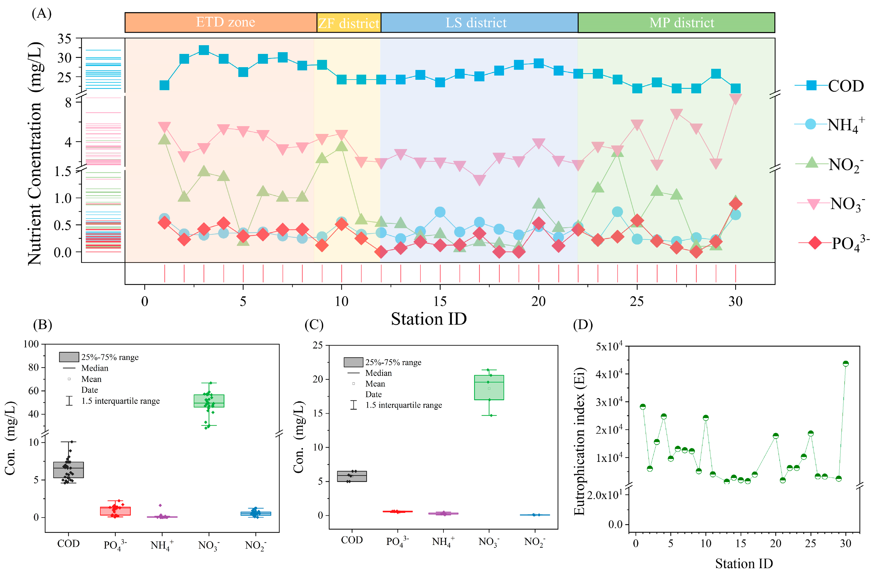
The distribution of nutrients along the coast is shown in Figure 2A. Among the three nitrogen forms, NO3 content was the highest, ranging from 1.35 to 8.44 mg/L (mean 3.56 mg/L), and NH4+ content was the lowest, ranging from 0.127 to 0.737 mg/L (mean 0.38 mg/L). NO2 content fluctuates widely, with a concentration range of 0.08–3.44 mg/L (mean 0.97 mg/L). The PO43− concentration in most areas ranged from 0 to 0.58 mg/L (mean 0.28 mg/L). However, in a few samples collected from the Muping District, the concentration of PO43− was higher than 0.89 mg/L. The concentration range of COD was 22.0–31.9 mg/L (mean 25.87 mg/L). The results show that the coastal seawater of Yantai was lower than the Class IV seawater standard (China National Standards) (Table S2), indicating that the pollution is serious. Compared to the Zhifu and Laishan districts, the nutrient content in the Economic and Technological Development Zone and the Muping district fluctuated more, and the concentration was slightly higher. Furthermore, both the Economic and Technological Development Zone and the Muping district were closer to the mariculture zone. Previous studies have shown that mariculture increases nitrogen and phosphate in coastal areas, and nitrate accounts for a large proportion of inorganic nitrogen in water [27], which agrees with the findings of this study.
Figure 2B,C show that the eutrophication of coastal seawater was affected by the two rivers entering the sea from water samples collected and analyzed at 35 sites along the Jiahe and Qinshui Rivers. Nutrient element pollution in the Jiahe River is more serious than that in the Qinshui River, especially regarding nitrogen content, where NO3 content was 30.42–66.83 mg/L (mean 49.05 mg/L) and 14.76–21.42 mg/L (mean 18.66 mg/L), respectively; much higher than the average concentration of 3.56 mg/L in seawater samples. Phosphorus pollution was also serious in both rivers. The average concentration of PO43− in the Jiahe River and Qinshui River was 0.97 mg/L and 0.58 mg/L, respectively, which was higher than the average concentration of 0.28 mg/L in seawater samples. According to survey data from the United States Geological Survey, among three types of rivers flowing through farmland (n = 104), urban areas (n = 38), and forests (n = 36), those passing through farmland exhibit the highest nutrient concentrations on a flow-weighted basis, with nitrogen and phosphorus concentrations approximately 4.3 mg/L and 0.28 mg/L, respectively. Rivers flowing through urban areas have nitrogen and phosphorus concentrations, roughly half of those flowing through farmland, while those passing through forests have even lower concentrations [28]. Clearly, the nitrogen and phosphorus pollution levels in Jiahe River and Qinshui River appear to be worse than the general global level, especially in terms of nitrogen pollution. The accumulation of pollutants in rivers ultimately enters the sea, somewhat exacerbating eutrophication in coastal areas. Therefore, the results indicate that the two rivers were affected by urban industrial and agricultural activities. Nitrogen and phosphorus pollutants continue to flow into rivers and eventually enter the ocean, intensifying the eutrophication of coastal seawater to some extent. Unlike nitrogen and phosphorus pollutants, the average concentration of COD in the two rivers is only 6.49 mg/L and 5.79 mg/L, respectively, which is less than the average concentration of seawater samples of 25.87 mg/L. This result indicates that the main source of COD pollution in Yantai coastal waters is not the inflow of land rivers and transport of COD by ocean hydrodynamic action must be considered.
To better understand the eutrophication of coastal seawater in the Yantai area, we selected a suitable method for evaluation. Common eutrophication evaluation methods include trophic index, chlorophyll-a biomass classification scheme, eutrophication index, etc. This study aimed to evaluate the effects of human activities on nearshore eutrophication, so more attention was paid to nutrient enrichment caused by sewage discharge than to the increase in phytoplankton biomass caused by nutrient excess. Based on this goal, the eutrophication index evaluation method based on carbon, nitrogen, and phosphorus content is a better choice for this study. The Ei value of the investigated area was calculated (Figure 2D). The Ei range of the Yantai coastal area was 1367–43,715. The results for all sampling sites were much higher than the criteria for severe eutrophication, indicating that the coastal seawater of Yantai is in a serious state of eutrophication and that remediation measures are urgently needed.

3.2. General Characteristics of Sediments

The grain size composition and TOC content of the sediment samples were determined, and their general characteristics were obtained (Figure 3). The sediment in the survey area is mainly sand, followed by silt. A few sampling sites with gravel distribution were located in scenic spots such as bathing beaches and tourist islands, which may be because the artificial maintenance of scenic spots changed the transport law of coastal sediments in the natural state. The average contents of sand and silt were 94.54% and 2.68%, ranging from 71.71% to 99.90% and 0.05% to 4.51%, respectively. The clay content was the lowest, at only 0–1.65%. The proportion of fine sediments (silt + clay) in the Economic and Technological Development Zone was relatively high. In the Muping District, at sampling sites 25 and 26 of the estuary of the Qinshui River, there was an increase in fine sediment, indicating that the river carried fine sediment from the land into the sea and settled in the estuary. The ratio of TOC content to dry sediment weight ranged from 0.04% to 0.78%, which was lower than the previously reported TOC content of 0.9% to 7.2% in coastal sediments of Bohai Bay [29]. This may be because the investigation area of this study was mainly concentrated in Yantai City, and resources along the coast were developed. Most of the carbon sequestration at the surface occurs in fine-grained sediments at the continental margins [17,30]. Furthermore, clay content—an important carrier of organic matter storage—was much lower than in other coastal areas undisturbed by human activities, resulting in a lower TOC content in sediments.

3.3. Occurrence and Distribution of Heavy Metals

The heavy metal content in seawater and sediments from 30 sampling sites in the coastal zone of Yantai City are shown in Figure 4A, where the average concentrations of all seven heavy metals are ranked from high to low as follows: Cu > Zn > Cr > Pb > As > Cd > Hg. The content of Cu and Pb in seawater decreased from west to east along the coastline, and Cu was the most abundant heavy metal element in all marine surveyed waters, with a concentration range of 134–287 μg/L (mean 197 μg/L), much higher than the upper limit of 50 μg/L standard for Class IV seawater [31]. The high concentration of Cu was significantly concentrated in the Economic and Technological Development Zone (p < 0.05). Zhifu Island slowed the exchange of seawater, and the discharge of wastewater from metal smelting companies may be the reason for its heavy pollution. Furthermore, the contents of Zn, As, Cr, Cd, and Hg did not show significant differences in their spatial distribution. The detection results of the sediment samples are shown in Figure 4B. Among the seven heavy metal elements detected, Cd was the only element whose content was below the detection limit of 0.08 μg/g at the 30 sampling sites. The concentrations of Zn, As, Cu, and Hg all decreased from west to east along the coastline, and the areas with high concentrations were concentrated in the Economic and Technological Development Zone, proving this is an important area of heavy metal pollution in the coastal area of Yantai. Zn and Cu showed higher concentrations at sampling sites 26 and 27 in the estuary of the Qinshui River, indicating that the Qinshui River brought a certain amount of heavy metals from the inland and settled in the estuary. Furthermore, the Cu content in seawater was much higher than other heavy metals, but its concentration in sediments was lower than Pb, Zn, and Cr, indicating that in the coastal waters of Yantai, a large amount of Cu was free in seawater and did not settle over time.
To better evaluate the heavy metal pollution in the coastal zone of the Yantai urban area, recent studies on the distribution of heavy metals in sediments from different regions are summarized in Table 1. The degree of heavy-metal pollution in this study was relatively low. Pb was the highest heavy-metal element in the coastal sediments of Yantai City, with an 18.3–34.9 μg/g concentration range and 24.46 μg/g average value, which was between the nearby Dongying and Weihai areas. Except for Pb, the average concentrations of all other heavy metals were lower than those of coastal areas (Table 1). Taking the Yangtze River estuary as the boundary including the Yangtze River estuary, the area to the north includes the Yellow Sea coastal zone, the coastal areas of Dongying and Weihai, and the western and southern coasts of North Korea, which were the same as the Yantai coastal area. Zn, Cr, Cu, and Cd were significantly lower than those in the southern area, including the coastal areas of the Zhoushan Islands, the northern part of the South China Sea, and the Pearl River Estuary.
A correlation analysis was conducted between heavy-metal distribution and the grain size composition in sediments (Table 2). Previous studies have shown that when there is a significant positive correlation between multiple heavy metals, it indicates that the distribution of these heavy metals is affected by the same source [38,39,40]. The spatial distribution of Pb negatively correlated with As but was not significantly correlated with other heavy metals, indicating that Pb may be an independent pollution source. There were no significant correlations between Cu and As, Cr, and Zn, or As. Furthermore, the distribution of other metal elements showed a significant positive correlation, indicating that heavy metal pollution in sediments is a common cause. According to the correlation analysis between heavy metals and TOC, there is a significant positive correlation between Cr and TOC. Jardine et al. [41] showed that the adsorption capacity of soil for Cr increased with an increase in the TOC content in the soil, and the bioavailability of Cr decreased with an increase in TOC content in the soil, which agrees with this study. The correlation analysis of the heavy-metal distribution and grain size composition in the sediments showed that Zn, Hg, Cu, and As were significantly affected by the grain size composition and were primarily correlated with the clay and silt, whereas the distribution of Pb and Cr appeared to be unaffected by grain size composition. The surface activity of sediment particles significantly influences the fate of pollutants, and sediment particle characteristics are strongly influenced by particle size [42]. Fine-grained sediments benefit from their strong electroactivity and larger specific surface area, making them more susceptible to heavy metal adsorption as inorganic particles [43,44].
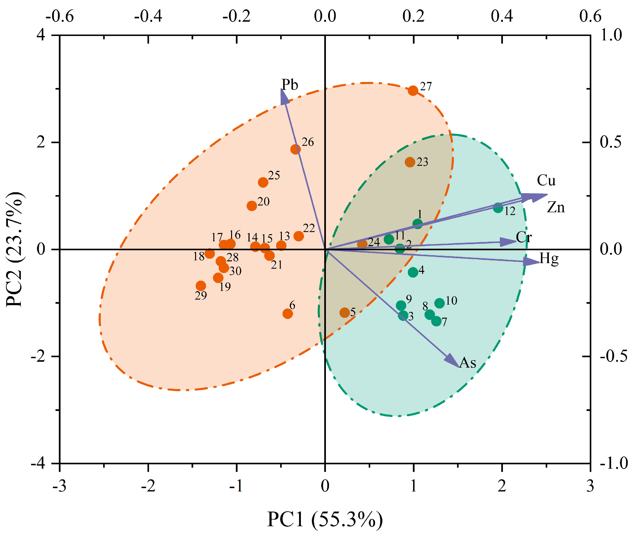
Hierarchical cluster analysis was performed on the sampling points based on the distribution of heavy metals in the sediments (Figure 5). At sampling sites No. 1–12, except for No. 5 and 6, the others were clustered into one category earlier, indicating that most areas of the Economic and Technological Development Zone and Zhifu District had relatively heavier pollution. In sampling sites No. 13–30, except for No. 23 and 27, the others were clustered into one category earlier, indicating that most areas in the Laishan and Muping Districts had relatively less pollution. Based on the cluster analysis results, the sampling points were divided into two categories for principal component analysis. As shown in Figure 6, the cumulative variance contribution rate of the first two principal components reaches 79.0%, representing the main information of the sample. Cu, Zn, Cr, and Hg had similar and relatively high positive loads on the first principal component (PCl 1), whereas As had relatively low positive loads on the first principal component (PCl 1); Pb had high negative loads on the first principal component (PCl 1), but high positive loads on the second principal component (PCl 2). These results indicated that Cu, Zn, Cr, and Hg may have similar sources, whereas As and Pb may have separate sources. Furthermore, the projection of the sampling points shows that heavy-metal pollution in the Economic and Technological Development Zone and the Zhifu District was mainly dominated by Cu, Zn, Cr, Hg, and As, whereas that in Laishan and Muping Districts was mainly dominated by Pb.

3.4. Evaluation of Heavy-Metal Pollution

With the gradual deepening of geochemical research, there are an increasing number of evaluation methods for heavy-metal pollution. Researchers have systematically evaluated heavy-metal pollution in different regions using different evaluation methods and achieved good results. Common heavy metal pollution assessment methods include the geoaccumulation index, potential ecological risk assessment (ERI), anthropogenic enrichment assessment, heavy metal enrichment factor (EF), etc. [22,24,45,46]. In this study, the EF and the ERI were selected to assess the degree of pollution and the potential ecological risk of heavy metals in sediments along the coastal area of Yantai City.
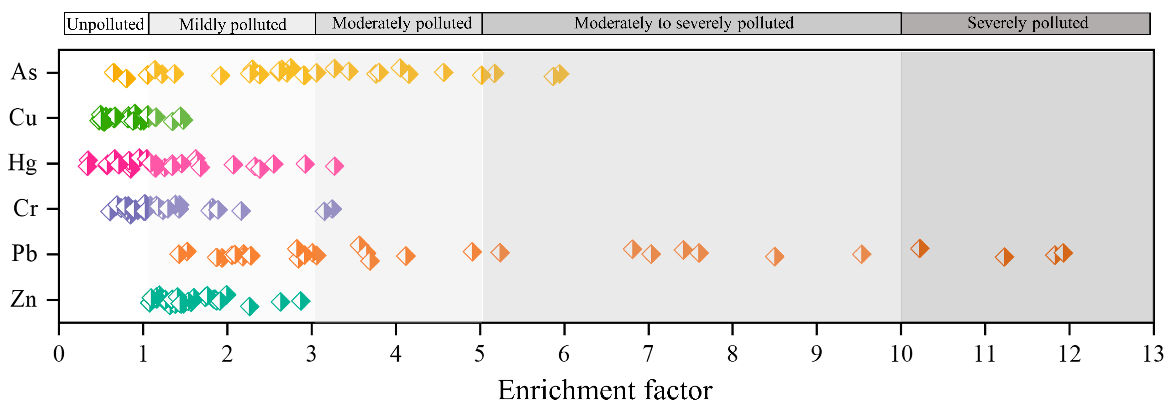
The EF is a normalization technique that can eliminate the influence of mineralogy and changes in grain size and more accurately assess the influence of human activities on heavy-metal content in sediments [47]. Al and Fe are two elements that are usually selected as normalized proxies. Considering that the natural concentration of Fe in sediments is more uniform than that of Al and is less influenced by humans [22], Fe was selected as the principal reference element in this study. The calculation results for EF are shown in Figure 7. Pb was the most severely polluted heavy metal in the study area, with an average EF of 4.98. However, the degree of Pb pollution at the different sampling sites varied greatly, ranging from mild to severe. Followed by As, the average EF was 3.04, which indicated moderate pollution. The average EF values for Zn, Hg, and Cr were 1.60, 1.33, and 1.26, respectively, indicating these three elements were less enriched and suggested mild pollution. The average EF of Cu was 0.79, which was the lightest polluting heavy-metal element in the sediments. Zn, Hg, Cr, and Cu had low degrees of enrichment in the sediments; therefore, the input of these elements by human activities was small, and the main source came from the natural environment. However, Pb and As were enriched in the investigated area, indicating they were at a higher pollution level in the sediments. This high enrichment indicates that the distributions of Pb and As are significantly affected by human activities, which is worthy of attention.
Pb originating from human activities is released into the atmosphere and transported by wind over long distances, which alters the Pb content in the marine environment through aerosol deposition [48]. According to Wu et al. (2021), recent sources of anthropogenic Pb pollution in the Yellow Sea were mainly from aerosol deposition transported by industrial activities such as combustion and smelting in northern China [49]. Therefore, aerosol deposition may be an important source of Pb in the coastal sediments of Yantai. Heavy-metal pollution was dominated by As at sampling sites 7–10, located south of the Zhifu Island mariculture area, which follows the conclusion of previous studies that As-containing aquaculture feed additives released in mariculture farms was the main source of As pollution in surface sediments in coastal areas [50].
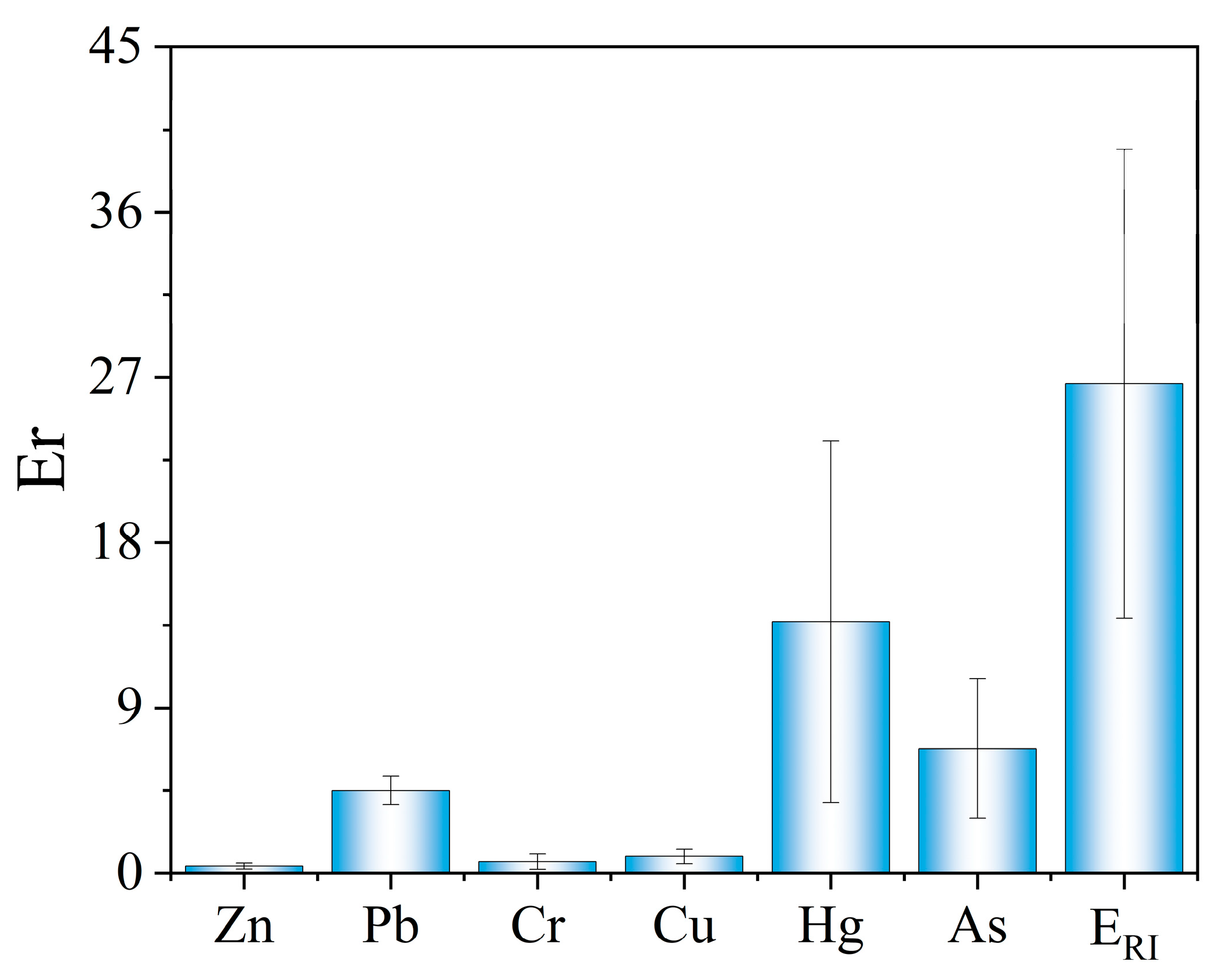
Because the toxicity of different heavy metals varies, the volume of heavy metals is not representative of the ecological risk they pose. The potential ecological risk index method proposed by Hakanson can be used to assess the combined pollution status and environmental impact of heavy metals in sediments using toxicological methods [19]. The E r i of each heavy-metal element at different sampling sites is shown in Figure 8, and the average E r i of the six heavy-metal elements in the Yantai coastal zone was Hg > As > Pb > Cu > Cr > Zn from largest to smallest. However, Hg, the heavy metal with the lowest content, had the highest E r i . Furthermore, the E r i of the six heavy metals in the entire survey area were lower than 40, indicating that the possible ecological risk caused by a single heavy metal was low. The result of ERI is shown in Figure 8. The Yantai urban coastal zone was at low potential ecological risk of heavy-metal pollution, with the ERI ranging from 11.53 to 54.48 (average 26.67), lower than the 150-limit value for low-risk division. The survey area in this study covers the coastal zones of the four administrative districts with the most intensive human activities in Yantai City. Therefore, it is expected that the coastal zones in other areas of Yantai City will not have a higher degree of heavy metal pollution.

4. Conclusions

In this study, we systematically determined the concentrations of nutrients and heavy metals in the water and sediments of coastal areas (Yantai, China) and assessed their sources and ecological risks. The indicators of the coastal seawater in Yantai City were lower than the Class IV standard. Inland rivers transport large amounts of NO3 and PO43− into the sea, which is an important cause of increasing offshore eutrophication. Hence, it is imperative to implement relevant measures to control eutrophication urgently. Yantai coast is not a Pacific West Coast heavy metal pollution serious area. Ecological risk assessment indicated that the coastal zone of Yantai City is light pollution with a low enrichment factor. Cu was the most abundant heavy metal in seawater and the only heavy metal that exceeded the Class IV standard. Meanwhile, lead and arsenic were dominant in sediment, which was sourced from aerosol deposition and mariculture, respectively. The grain size composition of the sediment is significantly correlated with the distribution of zinc, mercury, copper, and arsenic. This study provides a reference for the pollution prevention of general coastal cities and suggests that we should pay attention to the excess emission of nutrients and prevent the occurrence of coastal eutrophication.

Supplementary Materials

The following supporting information can be downloaded at https://www.mdpi.com/article/10.3390/w16050760/s1. Table S1: Station ID of monitoring sampling points in the four main administrative areas; Table S2: The Class IV seawater standard (China National Standards (GB 3097-1997)).

Author Contributions

Conceptualization, J.L.; Methodology, M.L.; Software, M.L. and K.B.; Formal analysis, S.W.; Investigation, S.L. and Q.Y.; Resources, Y.D.; Data curation, H.W. and K.Y.; Writing—original draft, M.L.; Writing—review & editing, J.L.; Supervision, K.B.; Funding acquisition, K.B. All authors have read and agreed to the published version of the manuscript.

Funding

This work was supported by the China Geological Survey Project (Grant No. DD20220990) and the Science and Technology Innovation Fund of the Command Center of Natural Resources Comprehensive Survey (Grant No. KC20220011).

Data Availability Statement

Data is contained within the article (and Supplementary Materials).

Conflicts of Interest

The authors declare that they have no known competing financial interests or personal relationships that could have appeared to influence the work reported in this paper.

References

  1. Ward, N.D.; Megonigal, J.P.; Bond-Lamberty, B.; Bailey, V.L.; Butman, D.; Canuel, E.A.; Diefenderfer, H.; Ganju, N.K.; Goñi, M.A.; Graham, E.B.; et al. Representing the function and sensitivity of coastal interfaces in Earth system models. Nat. Commun. 2020, 11, 2458. [Google Scholar] [CrossRef]
  2. Zhao, J.; Yang, K.; Chu, F.; Ge, Q.; Xu, D.; Han, X.; Ye, L. Sources and spatial variations of heavy metals in offshore sediments of the western Pearl River Estuary. Mar. Pollut. Bull. 2023, 188, 114599. [Google Scholar] [CrossRef]
  3. Kelly, N.E.; Guijarro-Sabaniel, J.; Zimmerman, R. Anthropogenic nitrogen loading and risk of eutrophication in the coastal zone of Atlantic Canada. Estuar. Coast. Shelf Sci. 2021, 263, 107630. [Google Scholar] [CrossRef]
  4. Sandonnini, J.; Ruso, Y.D.P.; Melendreras, E.C.; Barberá, C.; Hendriks, I.E.; Kersting, D.K.; Casalduero, F.G. The emergent fouling population after severe eutrophication in the Mar Menor coastal lagoon. Reg. Stud. Mar. Sci. 2021, 44, 101720. [Google Scholar] [CrossRef]
  5. Suzuki, C. Assessing change of environmental dynamics by legislation in Japan, using red tide occurrence in Ise Bay as an indicator. Mar. Pollut. Bull. 2016, 102, 283–288. [Google Scholar] [CrossRef]
  6. Rydin, E.; Kumblad, L. Capturing past eutrophication in coastal sediments—Towards water-quality goals. Estuar. Coast. Shelf Sci. 2019, 221, 184–188. [Google Scholar] [CrossRef]
  7. Richlen, M.L.; Morton, S.L.; Jamali, E.A.; Rajan, A.; Anderson, D.M. The catastrophic 2008–2009 red tide in the Arabian gulf region, with observations on the identification and phylogeny of the fish-killing dinoflagellate Cochlodinium polykrikoides. Harmful Algae 2010, 9, 163–172. [Google Scholar] [CrossRef]
  8. Dai, Y.; Yang, S.; Zhao, D.; Hu, C.; Xu, W.; Anderson, D.M.; Li, Y.; Song, X.-P.; Boyce, D.G.; Gibson, L.; et al. Coastal phytoplankton blooms expand and intensify in the 21st century. Nature 2023, 615, 280. [Google Scholar] [CrossRef] [PubMed]
  9. El Nemr, A.; El-Said, G.F.; Ragab, S.; Khaled, A.; El-Sikaily, A. The distribution, contamination and risk assessment of heavy metals in sediment and shellfish from the Red Sea coast, Egypt. Chemosphere 2016, 165, 369–380. [Google Scholar] [CrossRef]
  10. Anbuselvan, N.; Nathan, S.D.; Sridharan, M. Heavy metal assessment in surface sediments off Coromandel Coast of India: Implication on marine pollution. Mar. Pollut. Bull. 2018, 131, 712–726. [Google Scholar]
  11. Wang, C.; Zou, X.; Feng, Z.; Hao, Z.; Gao, J. Distribution and transport of heavy metals in estuarine-inner shelf regions of the East China Sea. Sci. Total Environ. 2018, 644, 298–305. [Google Scholar] [CrossRef] [PubMed]
  12. Ma, T.; Sheng, Y.; Meng, Y.; Sun, J. Multistage remediation of heavy metal contaminated river sediments in a mining region based on particle size. Chemosphere 2019, 225, 83–92. [Google Scholar] [CrossRef] [PubMed]
  13. Xiao, H.; Shahab, A.; Ye, F.; Wei, G.; Li, J.; Deng, L. Source-specific ecological risk assessment and quantitative source apportionment of heavy metals in surface sediments of Pearl River Estuary, China. Mar. Pollut. Bull. 2022, 179, 113726. [Google Scholar] [CrossRef]
  14. Steinhausen, S.L.; Agyeman, N.; Turrero, P.; Ardura, A.; Garcia-Vazquez, E. Heavy metals in fish nearby electronic waste may threaten consumer’s health. Examples from Accra, Ghana. Mar. Pollut. Bull. 2022, 175, 113162. [Google Scholar] [CrossRef] [PubMed]
  15. Zhao, M.; Wang, E.; Xia, P.; Feng, A.; Chi, Y.; Sun, Y. Distribution and pollution assessment of heavy metals in the intertidal zone environments of typical sea areas in China. Mar. Pollut. Bull. 2019, 138, 397–406. [Google Scholar] [CrossRef] [PubMed]
  16. Yang, L.; Ma, X.; Luan, Z.; Yan, J. The spatial-temporal evolution of heavy metal accumulation in the offshore sediments along the Shandong Peninsula over the last 100 years: Anthropogenic and natural impacts. Environ. Pollut. 2021, 289, 117894. [Google Scholar] [CrossRef] [PubMed]
  17. Wang, A.-J.; Bong, C.W.; Xu, Y.-H.; Hassan, M.H.A.; Ye, X.; Abu Bakar, A.F.; Li, Y.-H.; Lai, Z.-K.; Xu, J.; Loh, K.H. Assessment of heavy metal pollution in surficial sediments from a tropical river-estuary-shelf system: A case study of Kelantan River, Malaysia. Mar. Pollut. Bull. 2017, 125, 492–500. [Google Scholar] [CrossRef] [PubMed]
  18. Wang, Y.; Liu, D.; Richard, P.; Di, B. Selection of effective macroalgal species and tracing nitrogen sources on the different part of Yantai coast, China indicated by macroalgal δ15N values. Sci. Total Environ. 2016, 542, 306–314. [Google Scholar] [CrossRef]
  19. Tian, K.; Wu, Q.; Liu, P.; Hu, W.; Huang, B.; Shi, B.; Zhou, Y.; Kwon, B.-O.; Choi, K.; Ryu, J.; et al. Ecological risk assessment of heavy metals in sediments and water from the coastal areas of the Bohai Sea and the Yellow Sea. Environ. Int. 2020, 136, 105512. [Google Scholar] [CrossRef]
  20. Jiang, W.; Chu, H.; Liu, Y.; Chen, B.; Feng, Y.; Lyu, J.; Yuan, J.; Wang, L.; Li, J.; Hou, W. Distribution of heavy metals in coastal sediments under the influence of multiple factors: A case study from the south coast of an industrialized harbor city (Tangshan, China). Sci. Total Environ. 2023, 889, 164208. [Google Scholar] [CrossRef]
  21. Wei, Y.; Ding, D.; Gu, T.; Xu, Y.; Sun, X.; Qu, K.; Sun, J.; Cui, Z. Ocean acidification and warming significantly affect coastal eutrophication and organic pollution: A case study in the Bohai Sea. Mar. Pollut. Bull. 2023, 186, 114380. [Google Scholar] [CrossRef]
  22. Nethaji, S.; Kalaivanan, R.; Viswam, A.; Jayaprakash, M. Geochemical assessment of heavy metals pollution in surface sediments of Vellar and Coleroon estuaries, southeast coast of India. Mar. Pollut. Bull. 2017, 115, 469–479. [Google Scholar] [CrossRef]
  23. Pang, X.; Dai, J.; Chen, L.; Liu, H.; Yu, C.; Han, L.; Ren, T.; Hu, X.; Wang, H.; Wang, Z.; et al. Soil geochemical background values of 17 cities in Shandong Province. Shandong Land Resour. 2019, 35, 46–56. [Google Scholar]
  24. Hakanson, L. An ecological risk index for aquatic pollution control: A sedimentological. approach. Water Res. 1980, 14, 975–1001. [Google Scholar] [CrossRef]
  25. Wang, C.; Wang, Z.; Zhang, X. Distribution of eight heavy metals in the inner shelf sediments of East China Sea: Risk assessments and sources analysis. Ecosyst. Health Sustain. 2021, 7, 1888656. [Google Scholar] [CrossRef]
  26. Nour, H.E.; Helal, S.A.; Wahab, M.A. Contamination and health risk assessment of heavy metals in beach sediments of Red Sea and Gulf of Aqaba, Egypt. Mar. Pollut. Bull. 2022, 177, 113517. [Google Scholar] [CrossRef] [PubMed]
  27. Kang, P.; Xu, S. The impact of mariculture on nutrient dynamics and identification of the nitrate sources in coastal waters. Environ. Sci. Pollut. Res. 2016, 23, 1300–1311. [Google Scholar] [CrossRef] [PubMed]
  28. Wurtsbaugh, W.A.; Paerl, H.W.; Dodds, W.K. Nutrients, eutrophication and harmful algal blooms along the freshwater to marine continuum. Wiley Interdiscip. Rev. Water 2019, 6, e1373. [Google Scholar] [CrossRef]
  29. Gao, X.; Yang, Y.; Wang, C. Geochemistry of organic carbon and nitrogen in surface sediments of coastal Bohai Bay inferred from their ratios and stable isotopic signatures. Mar. Pollut. Bull. 2012, 64, 1148–1155. [Google Scholar] [CrossRef] [PubMed]
  30. Kennedy, M.J.; Wagner, T. Clay mineral continental amplifier for marine carbon sequestration in a greenhouse ocean. Proc. Natl. Acad. Sci. USA 2011, 108, 9776–9781. [Google Scholar] [CrossRef] [PubMed]
  31. GB 3097-1997; Third Institute of Oceanography SOA, Qingdao OUo. Sea Water Quality Standard. State Department of Environmental Conservation: New York, NY, USA, 1997.
  32. Zhen, W.; Longlong, L.; Xianxia, Z.; Shenghui, J.; Junfeng, G.; Shengjiang, Z. Distribution and pollution assessment of heavy metals in surface sediments along the Weihai coast, China. Mar. Pollut. Bull. 2023, 190, 114885. [Google Scholar]
  33. Wu, Z.; Dong, Y.; Liu, R.; Liu, L.; Gao, J.; Song, W.; Zhang, S.; Qiu, J. Assessment of heavy metal contamination in surface sediments off the Dongying coast, Bohai Sea. Mar. Pollut. Bull. 2022, 180, 113826. [Google Scholar] [CrossRef]
  34. Zhai, B.; Zhang, X.; Wang, L.; Zhang, Z.; Zou, L.; Sun, Z.; Jiang, Y. Concentration distribution and assessment of heavy metals in surface sediments in the Zhoushan Islands coastal sea, East China Sea. Mar. Pollut. Bull. 2021, 164, 112096. [Google Scholar] [CrossRef]
  35. Wang, Y.; Wang, Y.; Chen, X.; Zhang, L. Source-to-sink process and risk assessment of heavy metals for the surface sediment in the northern South China Sea. Environ. Sci. Pollut. Res. 2023, 30, 2721–2739. [Google Scholar] [CrossRef]
  36. Fan, H.; Chen, S.; Li, Z.; Liu, P.; Xu, C.; Yang, X. Assessment of heavy metals in water, sediment and shellfish organisms in typical areas of the Yangtze River Estuary, China. Mar. Pollut. Bull. 2020, 151, 110864. [Google Scholar] [CrossRef]
  37. Hwang, D.-W.; Kim, P.-J.; Kim, S.-G.; Sun, C.-I.; Koh, B.-S.; Ryu, S.-O.; Kim, T.-H. Spatial distribution and pollution assessment of metals in intertidal sediments, Korea. Environ. Sci. Pollut. Res. 2019, 26, 19379–19388. [Google Scholar] [CrossRef] [PubMed]
  38. Kwon, M.J.; Lee, J.Y.; Hwang, Y.H.; Jeon, S.-K.; Yang, J.-S.; Yun, S.-T.; Lee, S. Spatial distribution, mineralogy, and weathering of heavy metals in soils along zinc-concentrate ground transportation routes: Implication for assessing heavy metal sources. Environ. Earth Sci. 2017, 76, 802. [Google Scholar] [CrossRef]
  39. Chen, Y.-F.; Shi, Q.-Y.; Qu, J.-Y.; He, M.-X.; Liu, Q. A pollution risk assessment and source analysis of heavy metals in sediments: A case study of Lake Gehu, China. Chin. J. Anal. Chem. 2022, 50, 100077. [Google Scholar] [CrossRef]
  40. Zhou, W.; Dan, Z.; Meng, D.; Guo, J.; Zhou, P.; Chen, G. Analysis and Assessment of the Soil Environment Around a Plateau Municipal Solid Waste Incineration Plant. Soil Sediment Contam. 2023. [Google Scholar] [CrossRef]
  41. Jardine, P.M.; Stewart, M.A.; Barnett, M.O.; Basta, N.T.; Brooks, S.C.; Fendorf, S.; Mehlhorn, T.L. Influence of Soil Geochemical and Physical Properties on Chromium(VI) Sorption and Bioaccessibility. Environ. Sci. Technol. 2013, 47, 11241–11248. [Google Scholar] [CrossRef]
  42. Fukue, M.; Yanai, M.; Sato, Y.; Fujikawa, T.; Furukawa, Y.; Tani, S. Background values for evaluation of heavy metal contamination in sediments. J. Hazard. Mater. 2006, 136, 111–119. [Google Scholar] [CrossRef] [PubMed]
  43. Vitturi, L.M.; Molinaroli, E.; Pistolato, M.; Rampazzo, G. Sediment properties and their influence on the geochemical composition in the Lagoon of Venice. Boll. Oceanol. Teor. Appl. 1989, 7, 191–205. [Google Scholar]
  44. Ewais, T.A.; Grant, A.; Fattah, A.T.A. The role of surface coatings on sediments in sediment:water partitioning of trace elements and radionuclides. J. Environ. Radioact. 2000, 49, 55–64. [Google Scholar] [CrossRef]
  45. Brady, J.P.; Ayoko, G.A.; Martens, W.N.; Goonetilleke, A. Development of a hybrid pollution index for heavy metals in marine and estuarine sediments. Environ. Monit. Assess. 2015, 187, 306. [Google Scholar] [CrossRef] [PubMed]
  46. Muller, G. Heavy metals in sediment of the rhine-changes since 1971. Umsch. Wiss. Tech. 1979, 79, 778–783. [Google Scholar]
  47. Gao, X.; Chen, C.-T.A. Heavy metal pollution status in surface sediments of the coastal Bohai Bay. Water Res. 2012, 46, 1901–1911. [Google Scholar] [CrossRef] [PubMed]
  48. Chen, M.; Goodkin, N.F.; Boyle, E.A.; Switzer, A.D.; Bolton, A. Lead in the western South China Sea: Evidence of atmospheric deposition and upwelling. Geophys. Res. Lett. 2016, 43, 4490–4499. [Google Scholar] [CrossRef]
  49. Wu, B.; Wu, X.; Shi, X.; Zhang, X.; Qiao, S.; Hu, L.; Liu, J.; Liu, S.; Zhang, J.; Zhang, H.; et al. Lead isotopes in the Central Yellow Sea Mud: Evidence of atmospheric deposition and its implication for regional energy consumption shift. Environ. Pollut. 2021, 268, 115702. [Google Scholar] [CrossRef]
  50. Liu, J.-J.; Diao, Z.-H.; Xu, X.-R.; Xie, Q.; Ni, Z.-X. In situ arsenic speciation and the release kinetics in coastal sediments: A case study in Daya Bay, South China Sea. Sci. Total Environ. 2019, 650, 2221–2230. [Google Scholar] [CrossRef]
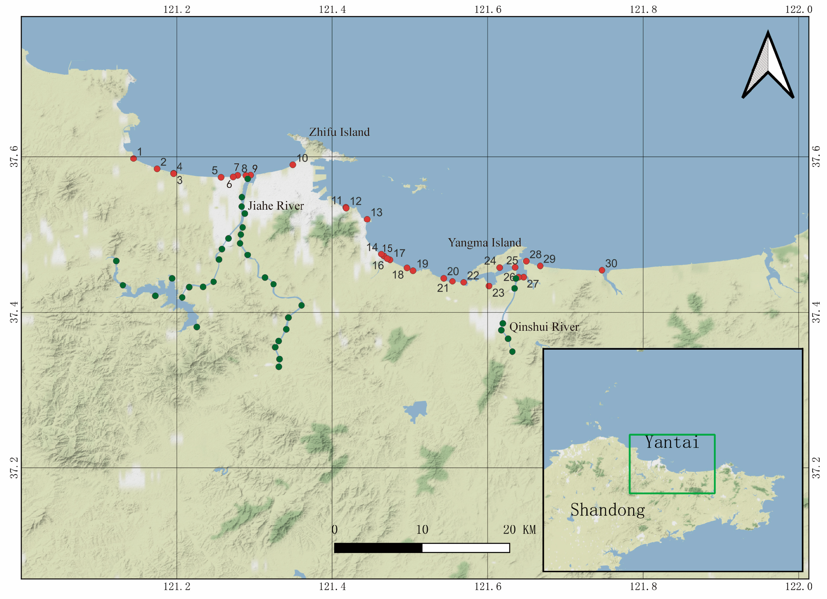
Figure 1. Distribution map of sampling points: coastal (red points) and sea-flowing rivers (Jiahe River and Qinshui River: green points) in Yantai.
Water 16 00760 g001
Figure 2. (A) Distribution of coastal nutrients in four districts of Yantai (ETD zone: Economic and Technological Development Zone; ZF district: Zhifu district; LS district: Laishan district; MP district: Mouping district); content of nutrients in water sample of Jiahe River (B) and Qinshui River (C); (D) coastal eutrophication index of four districts in Yantai.
Water 16 00760 g002
Figure 3. Grain size composition and TOC content of sediments in Yantai coastal zone.
Water 16 00760 g003
Figure 4. Distribution of heavy metals in seawater (A) and sediments (B) in the coastal zone of Yantai.
Water 16 00760 g004
Figure 5. Hierarchical cluster analysis tree diagram of heavy metals distribution in sediments.
Water 16 00760 g005
Figure 6. Principal component analysis of heavy metals in sediments.
Water 16 00760 g006
Figure 7. EF of different heavy metals in sediments at each sampling site.
Water 16 00760 g007
Figure 8. Potential ecological risk index of heavy metal elements in sediments.
Water 16 00760 g008
Table 1. Overview of heavy metal content in surface sediments of Yantai coastal area and distribution of heavy metals (unit: μg/g) in the surface sediments of other coastal areas (literature survey).
Location PbZnCrCuAsHgCdReference
Yantai coastrange18.3–34.911.7–45.310.4–51.41.8–9.81.4–9.50.006–0.032Below the detection limit of 0.08This study
mean24.4621.7320.824.44.240.014
Weihai coast 27.469.357.920.18.80.0360.1[32]
Dongying coast, Bohai Sea 21.670.266.422.512.8n.a.0.12[33]
Coastal areas of the Yellow Sea, China 26.0578.7260.3922.4910.580.0480.147[19]
Zhoushan Islands coastal sea, East China Sea 33.93107.7674.5167.848.230.050.2[34]
Northern South China Sea 38.5116.8704118n.a.0.34[35]
Yangtze Estuary 25.871.534.419.78.80.0650.13[36]
Pearl River Estuary 24.05119.2473.6331.3317.330.120.24[13]
The western and southern coasts of Korea 23.167n.a.12.87.40.0140.09[37]
Note: n.a. means not available.
Table 2. Pearson correlation coefficients of heavy metal composition, TOC and grain size composition in sediments.
PbCrHgCuAsTOCClay (%)Silt (%)Sand (%)Gravel (%)
Zn0.1680.3230.584 a0.941 a0.459 b0.1510.563 a0.506 a−0.3070.139
Pb −0.315−0.1170.096−0.492 a0.0440.122−0.0940.131−0.116
Cr 0.449 b0.503 b0.0220.542 a0.2290.166−0.1630.213
Hg 0.555 a0.482 b0.0220.542 b0.3900.078−0.170
Cu 0.2990.2750.444 b0.381−0.373 b0.262
As −0.2100.3800.484 b0.062−0.264
Note: a p < 0.01; b 0.01 < p < 0.05.
Disclaimer/Publisher’s Note: The statements, opinions and data contained in all publications are solely those of the individual author(s) and contributor(s) and not of MDPI and/or the editor(s). MDPI and/or the editor(s) disclaim responsibility for any injury to people or property resulting from any ideas, methods, instructions or products referred to in the content.