Article

Hydrogeochemical Behavior of Shallow Groundwater around Hancheng Mining Area, Guanzhong Basin, China

1
Shaanxi Union Research Center of University and Enterprise for River and Lake Ecosystems Protection and Restoration, Xi’an 710065, China
2
Power China Northwest Engineering Corporation Limited, Xi’an 710065, China
3
School of Water and Environment, Chang’an University, No. 126 Yanta Road, Xi’an 710054, China
*
Author to whom correspondence should be addressed.
Water 2024, 16(5), 660; https://doi.org/10.3390/w16050660
Submission received: 22 January 2024 / Revised: 13 February 2024 / Accepted: 21 February 2024 / Published: 23 February 2024

Abstract

:
A total of 18 samples of shallow groundwater around the Hancheng mining area in the Guanzhong Basin were collected from 1–4 May 2018. According to the analysis of hydrochemical data, the Gibbs semi-logarithmic diagram and Piper diagram were used to research the hydrogeochemical behavior of shallow groundwater around the Hancheng mining area in the Guanzhong Basin. The results of the groundwater hydrochemical analyses shown on the Gibbs and Piper plots are as follows: The chemical composition analysis showed that the main cation components were Mg2+, Ca2+, Na+, and K+, the anion components were HCO3, Cl, and SO42−. A measure of 89% of the groundwater samples in this area were freshwater, the HCO3 were mainly dolomite, calcite, and gypsum dissolved precipitation resulted. Na+ and Cl came from the dissolution of halite. Most of the groundwater was of the SO4·Cl-Ca·Mg type, accounting for 61.1%. The main ion chemistry of the shallow groundwater in this area is controlled by rock weathering, and pyrite oxidation is a significant factor affecting the SO42− concentration. These research results will help analyze the formation mechanism of chemical components and provide some basic data for the evolution of mine water in this area in the future.

1. Introduction

In the coal mining area, on the one hand, the large-scale drainage of groundwater is required due to the exploitation of coal seams; on the other hand, a large amount of water is needed for mine production and mining-area life [1,2,3]. At the Guqiao Coal Mine in Huainan City, Anhui Province, China, extensive groundwater extraction has resulted in a large amount of newborn ponding and the destruction of agriculture. Based on local characteristics, Hu et al. [4] developed a combination of coal extracted from the underground and reclamation of mining areas, as well as verified the model’s viability. The results showed that the parallel model of mining and reclamation can promote farmland protection and sustainable mining. In addition to the significant effect of coal exploration on the groundwater volume, the abandoned tailings produced by mining operations affect the groundwater environment. Some ions in mine water exceed the standard and carry a large number of dust, rock powder, and other suspended solids. The water quality is poor. It is necessary to clearly understand the major ions in groundwater, to further understand the interaction and mechanism of groundwater pollution. Hydrogeochemical facies can not only be used to evaluate the quality of groundwater but also provide information for distinguishing different regions of anions and cations in groundwater [5,6,7].
The long-term interaction between groundwater and the environment results in the chemical composition of groundwater [8,9]. The study of the hydrochemical composition and type of groundwater in a region can describe the hydrogeological history of the area [10], elucidate the origin and formation of the groundwater, and provide a visual evaluation of the groundwater quality to assess its availability or risk level. Currently, hydrogeochemical methods have made great progress in groundwater research, and the combined use of hydrochemical-type methods [11], isotope methods [12,13], thermodynamic methods [14], and multivariate statistical methods [15] has solved the quantitative and qualitative problems of hydrogeochemistry, and the hydrochemical method and isotope method are the most basic and practical methods. The hydrochemical-type method is mainly used to judge the qualitative study of the analysis of the major ion sources of groundwater in the target region, i.e., to analyze where the major ions in the groundwater come from in conjunction with the proportionality between the components, and to reveal the reaction processes of the major ions in the groundwater. The isotope method is used primarily for quantitative studies of major ion sources in groundwater.
To identify the hydrogeochemical processes at the mine site, many analysis and evaluation studies on the groundwater chemistry in mining areas have been carried out at home and abroad [16,17,18]. Zhang et al. [19] revealed the hydrochemical characterization in the multi-aquifer system of an abandoned mine in Huainan by using the Euclidean method and the Ward method to determine the genesis, evolutionary process, and fate of the hydrogeochemistry of the area by combining the stable hydroxide isotopes and reverse geochemical simulation methods. Ewusi et al. [20] carried out hydrochemical analyses and multivariate statistical analyses of surface water, groundwater, and mine pit water from the Nsuta manganese mine which is the biggest mine in western Ghana. The hydrochemical types of surface water and mine pit water–groundwater systems in the area were described, and the degree of contamination by ions and heavy metals and their risk level to human health were assessed.
The Hancheng mining area is an important coal mine production base in Shaanxi Province, where Ordovician karst is extremely developed and the water-rich nature of the karst water-bearing rock groups is extremely high. The groundwater recharge, runoff, and drainage system in the Hancheng mining area has become an independent hydrogeological unit. In recent decades, a number of large-scale water leakage incidents have occurred in the Hancheng mine, which has greatly threatened the production, economy, and safety of people’s lives in the mine. In order to safeguard the water security of the Hancheng mining area, it is urgent to identify the hydrogeochemical processes of shallow groundwater in this area to help develop an appropriate groundwater management plan. Xue et al. [21], according to the data of the water environment index analysis and rock chemical composition detection, analyzed the hydrogeological background of occurrence and distribution of the Ordovician limestone water quality in the Xiangshan Mine of the Hancheng Mining Area. They found that the mine water received a large amount of recharge from shallow pore diving. It is necessary to further identify the genesis and hydrogeochemical characteristics of shallow pore diving.
Based on the above research background in the Hancheng mining area, this paper is designed to study the hydrogeochemical behavior of shallow groundwater around the Hancheng mining area and clarify the causes of the main anions and cations in the groundwater. Taking the Gibbs diagram as a reference, the hydrogeochemical survey was carried out by using a pipeline diagram to determine the factors affecting the groundwater composition. Thus, the main research contents are: (1) to elucidate the main hydrochemical characteristics of shallow groundwater in the Hancheng mining area of Shaanxi Province, (2) the hydrogeochemical processes are distinguished according to their major ion chemistry, element ratio, and hydrogeochemical phases. This will contribute to the current water resources regulation in the area and offer theoretical support for the future evolution of mine water.

2. Materials and Methods
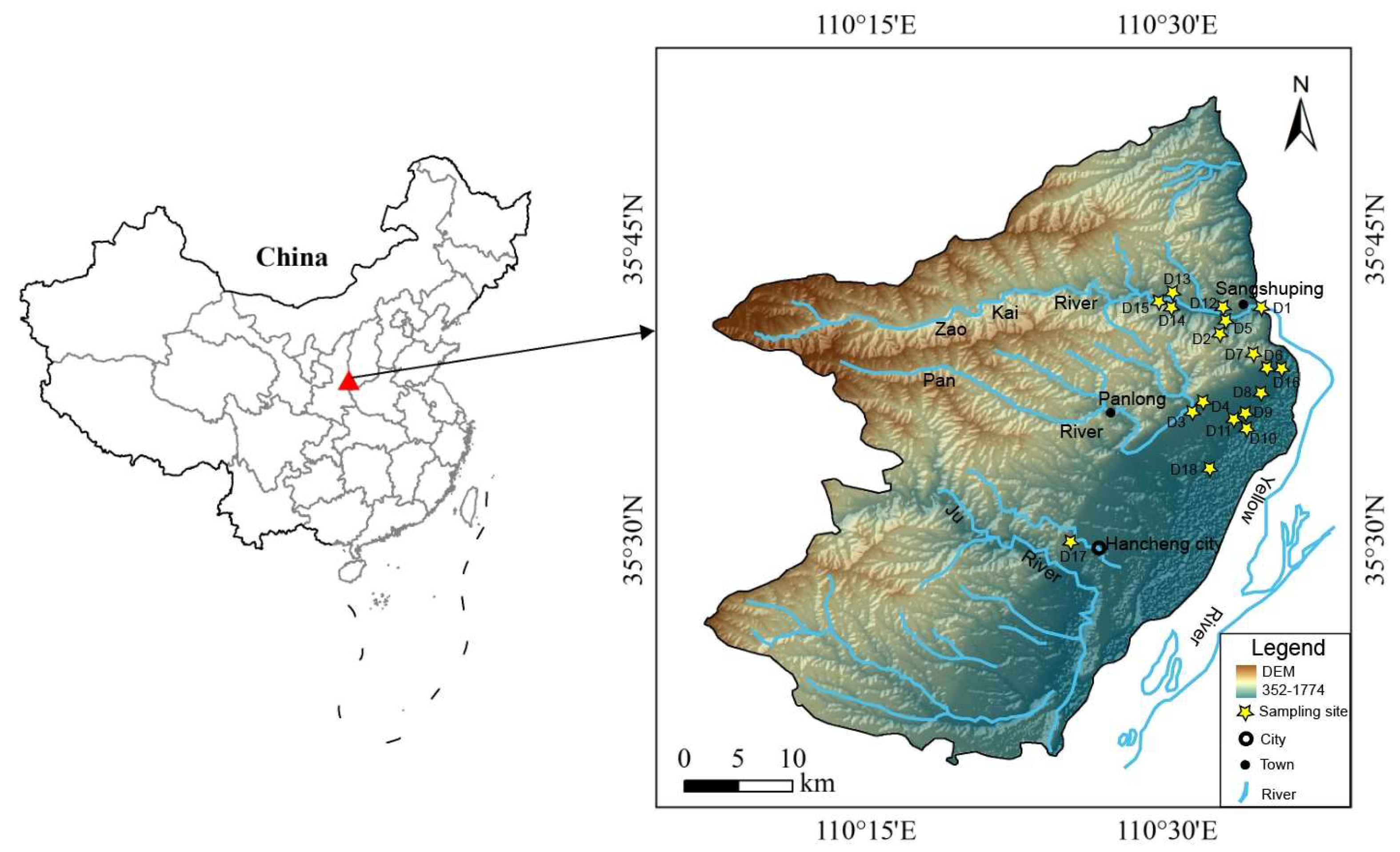
2.1. Study Area

The Hancheng mining area is situated at the intersection of the Jinxi fold belt and the Weibei uplift in the southeastern margin of the Ordos block in Shaanxi Province. It is located at the west of the Yellow River, and extends between longitude 110°07′19″–110°37′24″ and latitude 35°18′50″–35°52′08″ (Figure 1), with a total area of about 1115.7 km2.
The Hancheng mining area is located in arid and semi-arid areas and falls under the warm temperate semi-arid continental monsoon climate. The regional climate is dry, its annual average temperature is 13.8 °C. The precipitation is small and uneven in time and space. The precipitation is mostly concentrated in July–September. The annual average precipitation is 559.7 mm, while the annual evaporation is between 1119.4 and 1679.1 mm, resulting in a drought and water shortage in the region and a fragile ecological environment. The study area flows through the largest river-cut river, with abundant water throughout the year, which is the major water supply for residents around the mining area. The recharge, runoff, and drainage system of groundwater in this mining area is limited by geographical and geological factors to form an independent hydrogeological unit. The structure of the mining area is divided into different regions. The structures in the southern and eastern regions are strongly developed, and the structures in the northern and western regions are relatively weak. The structures in the shallow and edge regions are complex, and the structures in other regions are relatively simple. The south area is mainly tensile in structure, mainly fault; there are many extrusion structures in the north area, mainly fold. The Hancheng mining area belongs to the Weibei Carboniferous-Permian coalfield. The surface is covered by Quaternary loess. Ordovician carbonate rock is the base. There are three types of groundwater: pore water in the Quaternary loose layer, fissure water in the Permian and above-covered strata, and karst water in the Ordovician limestone fissure. Pore water mainly occurs in the Quaternary loess layer and alluvial diluvial layer on both sides of the valley. Under the control of topography, geomorphology, and recharge conditions, the groundwater level on the loess tableland is generally deep and the water quantity is poor. In the low-lying areas of the surface and on both sides of the valley, the groundwater level is shallow and the water is abundant. The thickness of the Quaternary loose layer is about 40 m. The aquifer consists of silty sand, fine sand, and gravel. The groundwater capacity is abundant, with a permeability coefficient of 1.93–6.73 m/d. The range for the mineralization degree of the phreatic water is from 630–750 mg/L.
Fractured water occurs in the Permian and Triassic aquifer groups. The unit water inflow of sandstone formation is 0.0000113~0.360000 L/(s·m), and the permeability coefficient is 0.0000903~1.07 m/d. It is an aquifer with weak water abundance and medium permeability [22]. The fissure water’s hydrochemical type is HCO3·SO4-Ca·Mg [23].
Karst water exists under the coal seam floor. The direct basement of the coal seam is a strong karst fissure aquifer section, which is composed of the second section of the middle Ordovician peak (O2f2), 0~75 m thick, and the main lithology is relatively single thick-layered limestone. The drilling unit water inflow is 1.31~3.22 L/(s·m), the permeability coefficient is 9~15 m/d, the water-rich layer is uniform, and belongs to a strong karst fissure aquifer.

2.2. Sample Testing and Analysis

From 1 to 4 May 2018, 18 groundwater samples were collected from the water samples collected by the research group from the Yellow River in the east, Yangshanzhuang in the west, Wangfeng in the north, and Guicun in the south. According to the sampling method, the samples were stored in white plastic bottles and numbered from D1 to D18 (Figure 1). After the collection, the groundwater samples were sealed to the laboratory for physical and chemical tests. The analyzed indices included the pH, total dissolved solids (TDS), total hardness (TH), cations (Ca2+, Mg2+, Na+, K+), and anions (HCO3, CO32−, SO42−, Cl, F). The pH was measured in the field using a portable tester, and the geographical coordinates and environmental conditions of the sampling points were recorded. An inductively coupled plasma emission spectrometer (ICAP6300) was used to analyze the cations Na+, K+, Ca2+, and Mg2+, while F, Cl and SO42− were measured by ion chromatography (ICS-2000), HCO3 was determined by titration. In the sample test, the quality control used 5% repeated samples, all repeated samples’ error was less than 5%.
This study used the Gibbs semi-logarithmic diagram and the Piper diagram to study the hydrogeochemical behavior of shallow underground water around the Hancheng mining area in the Guanzhong Basin. Piper diagrams [24] and Gibbs diagrams [25] are traditional methods widely used in hydrogeochemical studies. Piper diagrams consist of two triangles and a rhombus, with each side of the rhombus and the triangle as the axis, representing the percentage of milligram equivalents of all ions that are dissolved in the water, which visually demonstrates the relative contents of various ions, and has the advantages of being free from human influence and analyzing the chemical features and evolution of groundwater through the situation marked by the sample points. The traditional Gibbs diagram, with the TDS concentration value as the logarithmic vertical coordinate and the cation mass concentration ratio as the horizontal coordinate, reflects the main natural influences on the formation of groundwater hydrochemistry.

3. Results and Discussion

3.1. Chemical Characteristics of Groundwater

The range of water quality indicators for groundwater around the Hancheng mine is shown in Table 1. The groundwater in the study area had a pH range of 6.60 to 7.99, while its average was 7.38. The groundwater was neutral and weakly alkalescent, which met the basic limits of groundwater quality standards and was higher than the pH value of acid mine drainage 5.88 [21,22,23,26].
The F concentration of the groundwater in the Hancheng mining area is between 0.17 mg/L and 0.81 mg/L, averaging 0.32 mg/L. Against the grading standards of China’s drinking water quality standards for domestic drinking water [27], the F content in all groundwater samples collected from the Hancheng mine was less than 1.0 mg/L, indicating that the groundwater in the Hancheng mine is not contaminated with fluoride. The average contents of cations K+, Na+, Ca2+, and Mg2+ of the river water around the Hancheng mining area were 1.88 mg/L, 197.78 mg/L, 152.56 mg/L, and 275.11 mg/L, distinctly. The overall performance was K+ < Ca2+ < Na+ < Mg2+; the average content of HCO3 was 187.75 mg/L, and the concentration of SO42− was between 34.58 mg/L and 207.330 mg/L. The average number of HCO3 was 359.51 mg/L, and the average number of Cl was 44.811 mg/L. The overall performance was SO42− < Cl < HCO3. The major cation components in the groundwater of the Hancheng mine were Mg2+, Ca2+, Na+, and K+, and the anion components were HCO3, Cl, and SO42−. The Hancheng mining area’s groundwater’s major cations and anions were comparable to the surrounding river’s major cations and anions, as evidenced by the results.
The groundwater’s TDS in the Hancheng mining area ranged from 242.00 mg/L to 1090.00 mg/L, and its average was 613.67 mg/L. From the relationship map among conventional ions and TDS, it is clear that with the runoff of the Hancheng mining area from south to north, the major ions such as calcium, magnesium, chlorine, and sulfate show an accelerated growth trend, that is, the slope of the relationship curve between ions and TDS gradually increases, which shows that the hydrodynamic conditions are poor, that is, the runoff is relatively slow. Shallow groundwater in mining areas is the principal drinking water supply for native residents. Based on the classification of groundwater, 89% of groundwater samples were freshwater in this area (TDS < 1000 mg/L). The amount of water TH depends upon the total solubilized content of Ca2+ and Mg2+ [28,29]. The TH of the groundwater in the Hancheng mining area was between 576.9 mg/L and 2719.9 mg/L, while its mean was 1287.7 mg/L, suggesting hard water (TH > 450 mg/L) according to the classification of Chinese Standards for drinking water quality [27]. These TDS and TH values are close to those of Ordovician limestone water, indicating a similar recharge source.

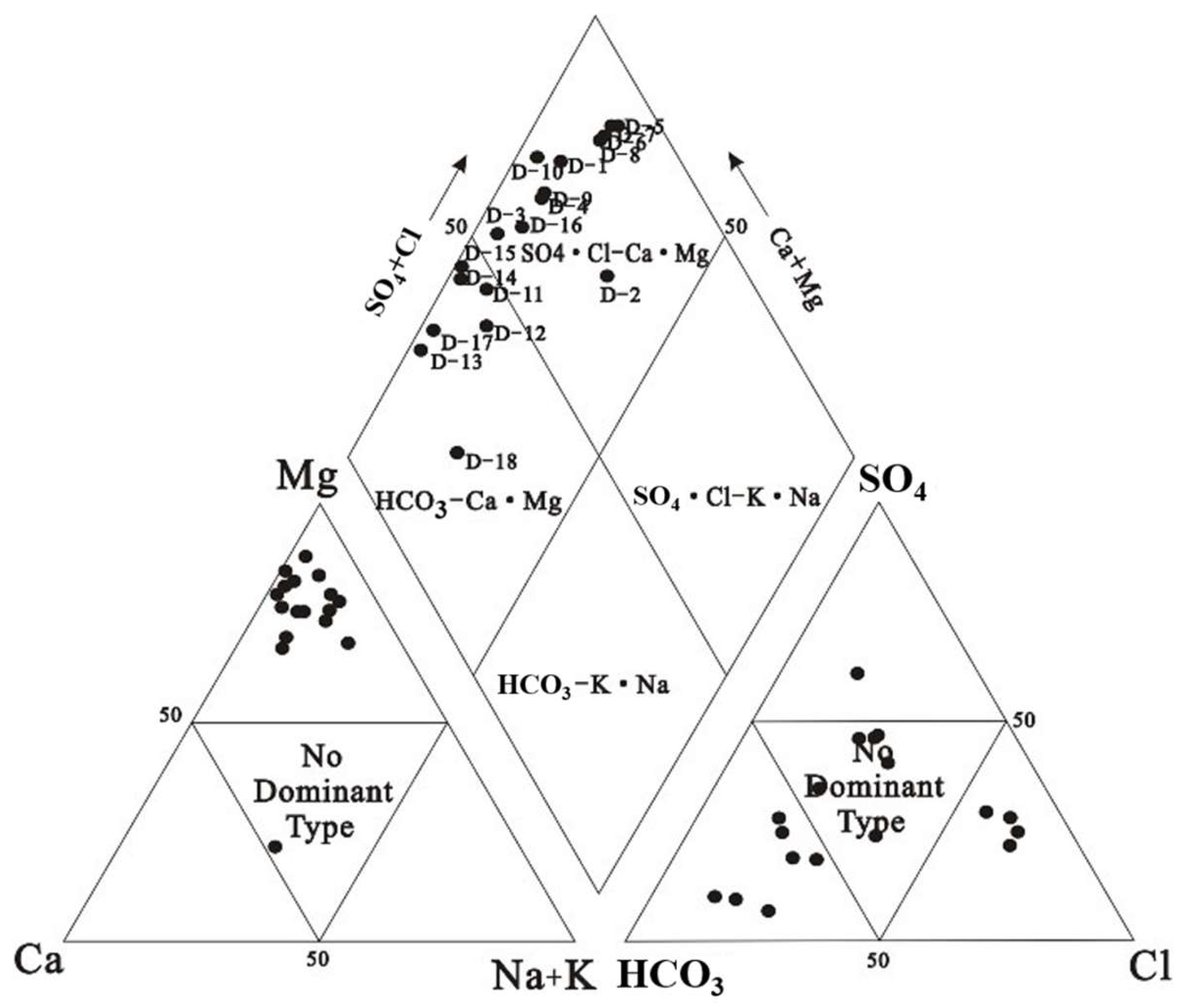
3.2. Hydrogeochemical Facies and Types

A Piper diagram based on the monitoring data of K+, Na+, Ca2+, Mg2+, HCO3, SO42, and Cl in the shallow groundwater of the Hancheng mining area was developed to analyze regional groundwater hydrochemistry types (Figure 2). The salinity range of the collected water samples was 242.00~1090.00 mg/L, and the anion content was SO42− < Cl < HCO3. The anion concentration ranges were 24.90~553.20 mg/L, 29.48~944.09 mg/L, and 176.91~506.25 mg/L, individually. The mean values were 277.78 mg/L, 251.06 mg/L, and 244.58 mg/L, individually. The Ca2+ concentration was generally in the range of 42.6~201.29 mg/L, and Mg2+ concentration was in the range of 43.22~540.88 mg/L (Table 1). Figure 2 demonstrated that the water quality types of different sampling points are different, the left lower triangular cation field reveals 94.4% of groundwater samples belong to the magnesium type. The lower right triangle anion field showed that 38.9% of the groundwater samples plunged into the carbonate field, about 33.3% of the groundwater samples plunged into the non-dominant field, and 22.2% of the groundwater samples plunged into the chloride ion field. The rhombus reveals that the groundwater samples belong to the type of basic earth metal surpassing alkaline metal in area 1. It shows that 38.9% of the groundwater samples are of the HCO3-Ca·Mg type and 61.1% of the groundwater samples are of the SO4·Cl-Ca·Mg type.

3.3. Effect of Natural Factors on the Chemical Composition of Groundwater

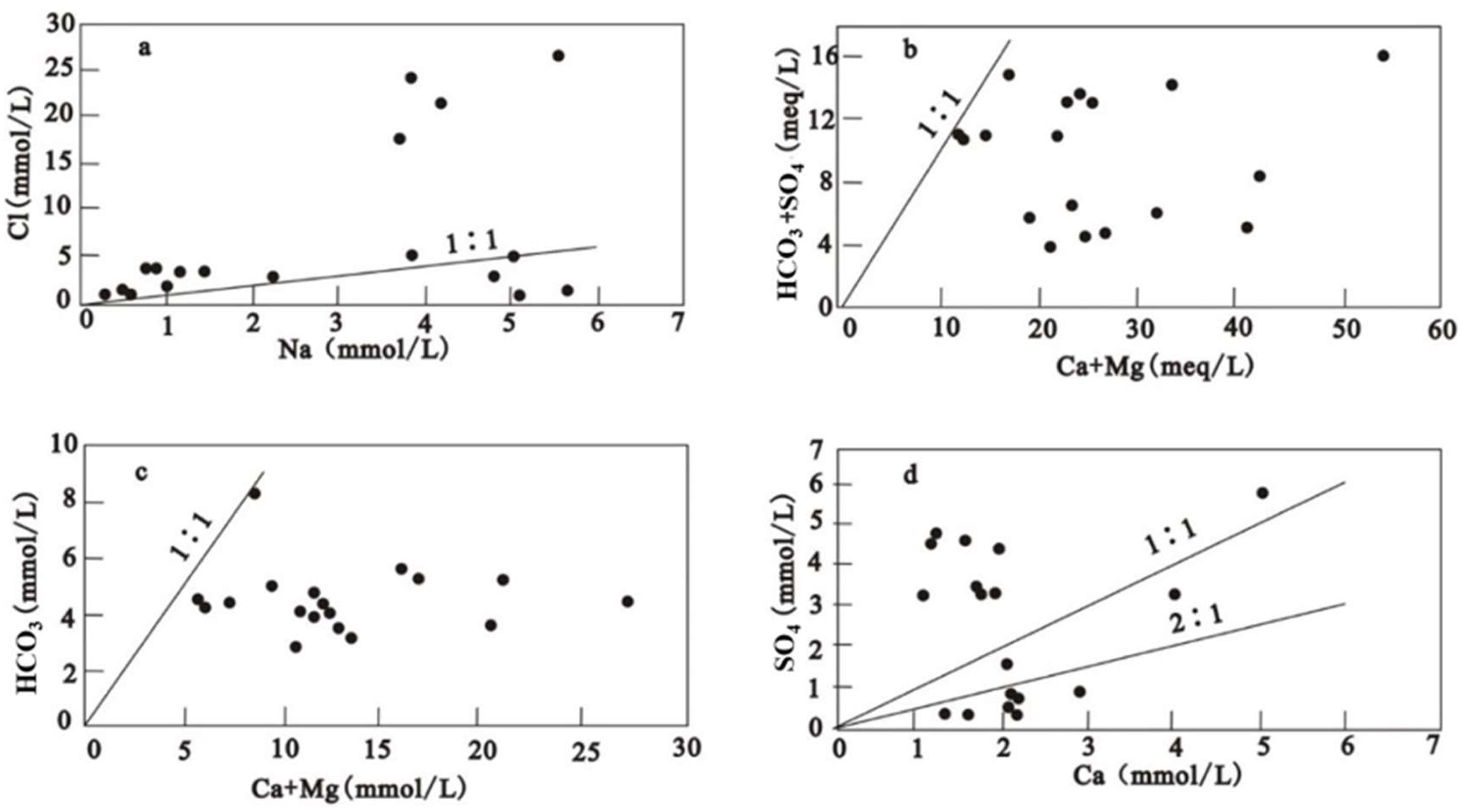
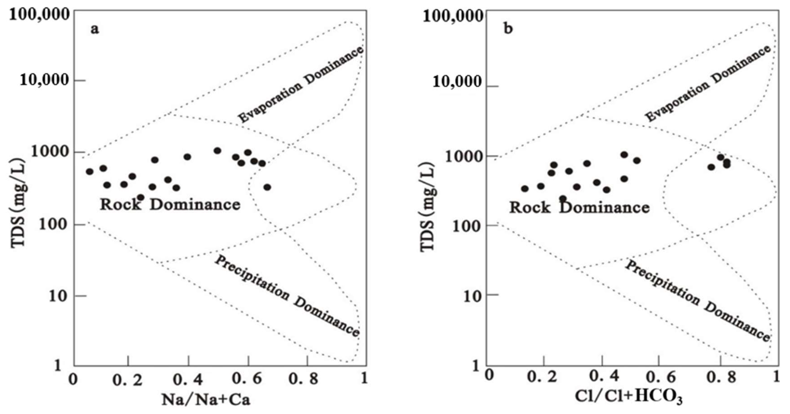
3.3.1. Rock Weathering

When the Gibbs diagram is employed to examine the formation mechanism of the dissolved chemical compositions of groundwater, the synchronous changes in the Na+ and Cl concentration indicate that they may be recharged by precipitation or concentrated by evaporation. However, in this study, except for a small number of sampling points, the equivalent concentration of Cl was above that of Na+, and the equivalent concentration ratio of Cl and Na+ gradually approached 1:1 on the whole (Figure 3a), indicating that the Na+, Ca2+, Mg2+, SO42−, Cl and HCO3 may be added to by rock minerals during the initial hydrochemical erosion process. The good linear relationship between the Cl and HCO3 concentrations can be verified when TDS ≤ 1000 mg·L−1 in Figure 4b. The results of the Gibbs chart analysis showed that the Na/ (Na+Ca) and Cl/ (Cl+HCO3) of most groundwater samples were less than 0.6 (Figure 4). The relative ratio of the ion concentration can demonstrate the origin of the main ions in the groundwater [30,31]. Most of the underground water samples were in the rock weathering zone, indicating that rock weathering controls the main ionic chemistry of the shallow groundwater in this area.

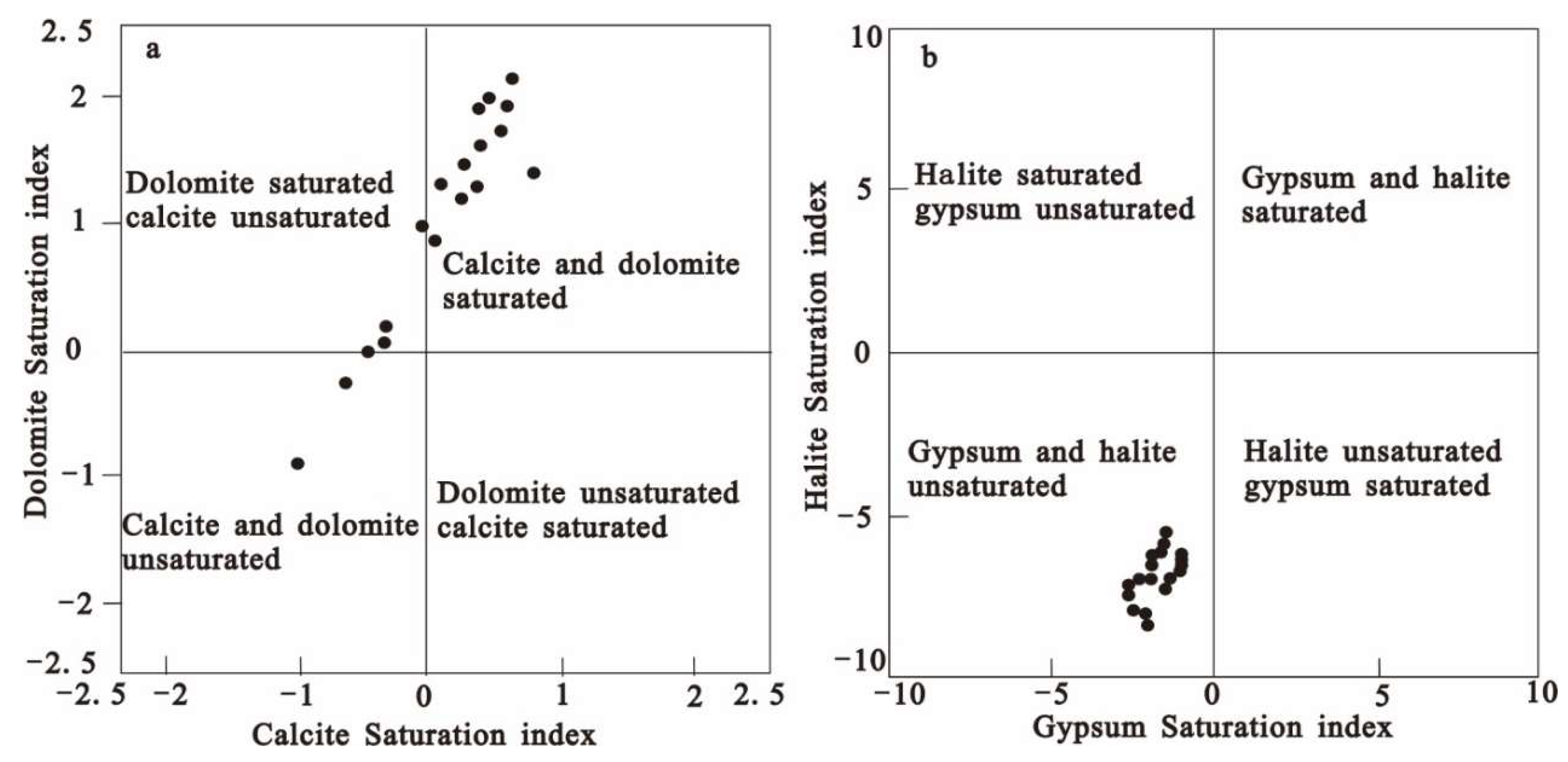
3.3.2. Mineral Dissolution or Precipitation

In the research of groundwater chemical process, the ion equivalent relationship between [(Ca2++Mg2+)-(SO42−+HCO3)] and [(Na++K+)-Cl] is frequently utilized to explore the impact of the water–rock interaction on groundwater chemical composition during the exchange reaction and dissolution [32]. The possibility of chemical reactions can be predicted through the calculation and analysis of the chemical equilibrium states between minerals and water for water-rock interactions [33]. Ca2+ increased significantly with the increase in TDS in the Hancheng mining area, indicating that gypsum dissolution occurred in the Hancheng mining area because gypsum dissolution was not related to the carbon dioxide content, but only related to water and time [34]. The relationship between Ca2+ and SO42− in Figure 3d was analyzed. Among the 18 groundwater samples collected, seven points dipped below the 2:1 ratio line, while nine points exceeded the 1:1 ratio line, and two points were positioned in the interval between the 2:1 line and the 1:1 ratio lines. The analysis results show that one of the sources of Ca2+ and SO42− is the dissolution of gypsum, and Ca2+ also has other sources. In Figure 3d, 50% of the groundwater samples exceed the 1:1 ratio line. Combined with the existing data, the research revealed that the groundwater in the Hancheng mining area is also affected by the presence of pyrite [35]. According to the previous analysis, the SIs of calcite, dolomite, gypsum, and quartzite are calculated by the PHREEQC program. The SI charts of calcite and dolomite show that most groundwater samples are supersaturated (Figure 5a). Supersaturation may give rise to the precipitation of Ca or Ca-Mg carbonate when the physical and chemical conditions in the environment are reasonable. About a third of (33.3%) the water samples were not completely dissolved calcite, and 16.7% were dolomite undersaturated. The gypsum and pyroxene SI diagram shows that every groundwater sample is unsaturated (Figure 5b), indicating that gypsum and pyroxene are more likely to dissolve in groundwater if gypsum and pyroxene are widespread in the Hancheng mining area.

3.3.3. Cation Exchange

The cation alternate adsorption is a general phenomenon in the hydrogeochemical process. Through the prolonged interaction between the groundwater and rock strata, the adsorption occupies a non-substitutable position in the chemical composition and change of groundwater. The common cation exchange process is sodium and calcium exchange [36]. The [Ca2++Mg2+-(HCO3+SO42−)]/(Na+-Cl) chart is often used to analyze the cation exchange effect in water. The [Ca2++Mg2+-(HCO3+SO42−)] means the content of Ca2+ and Mg2+ in water except for the dissolve behavior of dolomite, calcite, and gypsum; Na+-Cl is expressed as the content of Na+ after the weathering and dissolution of salt rock in water. If [Ca2++Mg2+-(HCO3+SO42−)]/(Na+-Cl) showed a linear relationship and the slope was −1, it indicated that as the continuous rise of Na+-Cl, and Ca2++Mg2+-(HCO3+SO42−) showed a declining tendency, indicating that there was a positive cation exchange effect in groundwater. If the cation exchange does not occur and only depends on the rock dissolution reaction, the scattered points should be concentrated near the (0, 0) origin in Figure 5. When the slope between the two was close to −1, it indicated that the exchange adsorption reaction played a significant role in the change of cation concentration in the water [37].
If the dissolving of calcite, dolomite, and gypsum is the major ions’ source of groundwater, the ratios of (Ca2++Mg2+) vs. (HCO3+SO42−) will be approaching the 1:1 ratio line. In this study, the ratios of (Ca2++Mg2+) vs. (HCO3+SO42−) decrease below the 1:1 line (Figure 3b). The Ca2+ and Mg2+ were greater than the HCO3+SO42−, indicating that Ca2+ and Mg2+ either exist in other sources or that some reactions consume the Ca2+ and Mg2+. The ratio of (Ca2+ and Mg2+) to (HCO3) in all groundwater samples of the aquifer was found to be less than 1:1 (Figure 3c). This indicates that Ca2+ and Mg2+ do not originate completely from the dissolving of calcite and dolomite, and were balanced by some other anions like SO42− [38,39].
In the study of the cation exchange in water, to gain a deeper understanding of the process of the positive and negative alternating adsorption of cations in water, the chloralkali index (CAI) [40] is usually introduced:
CAI-1 = [Cl-(Na++K+)]/Cl
CAI-2 = [Cl-(Na++K+)]/(HCO3+SO42−+CO32−+NO3)
If the Ca2+ and Mg2+ in groundwater are supplanted by Na+ in the rock and soil, CAI-1 and CAI-2 > 0, reverse cation exchange occurs, that is, the Na+ in water is supplanted by the Ca2+ and Mg2+ in the rock and soil [41]. According to the calculation statistics, about 83.3% of the groundwater samples in this study had optimistic effects indicating the exchange of Na+ and K+ in groundwater with Ca2+ and Mg2+ in the aquifer, and about 16.7% had negative values indicating the ratio of anti-ion exchange (Figure 6). Combined with Figure 3a, with the Na+/Cl being less than 1:1 and the relationship curve between groundwater samples (Ca2++Mg2+) and (HCO3+SO42−), it is shown that all samples fall below the isoline, indicating that the alkali exchange reaction and Ca2++Mg2+ occur at higher concentrations. This shows that the Ca2+ and Mg2+ in the aquifer minerals have been exchanged by Na+ in groundwater.

3.4. Effects of Human Activities on the Chemical Composition of Groundwater

The relative ratio of ion concentration can reflect the source of main ions in groundwater [42]. The Na+ vs. Cl can reflect the source of Na+ [43]. As demonstrated by Figure 3a, 83.3% of groundwater samples fall above the 1:1 ratio line, indicating that Cl is higher than Na+; coal gangue and coal in the Hancheng mining area contain a certain amount of Cl, and agricultural activities are frequent, indicating that coal gangue leaching water and agricultural irrigation runoff are the major sources of Cl in the groundwater [44,45].

4. Conclusions

On the basis of the data of 18 groundwater samples collected from the Hancheng mining area, this paper collects and summarizes the local topography, geomorphology, hydrogeology, and other data. Based on the basic theory of hydrology and geology, the hydrochemical evolution law of groundwater in the surrounding area of the Hancheng mining area in Shaanxi Province is explored using the hydrochemical method. The conclusions are as follows:
(1)
The main cation components in the groundwater in the Hancheng mining area were Mg2+, Ca2+, Na+, and K+, and the anion components were HCO3, Cl, and SO42−. An amount of 89% of the groundwater samples in this area were freshwater (TDS < 1000 mg/L). The chemical type of the groundwater was mainly of the SO4·Cl-Ca·Mg type, accounting for 61.1%, followed by the HCO3 Ca·Mg type, amounting to 38.9%.
(2)
The chemical components of the groundwater in the Hancheng mining area are mainly affected by rock weathering, and there is a cation exchange. Na++Cl originates from the dissolved halogen, Ca+ comes from the dissolved gypsum, and the SO42− concentration is affected by pyrite oxidation. Not only are the Cl and SO42− regulated by natural factors, but they are also influenced by human activities. According to the analysis of the saturation index, gypsum and salt rock in the groundwater in the Hancheng mining area are in an unsaturated state and will be dissolved continuously. Dolomite and calcite are generally in a saturated or quasi-equilibrium state, with a precipitation trend.

Author Contributions

Formal analysis, L.D. and Y.S.; Investigation, L.D. and Y.S.; Resources, X.K.; Writing—original draft, Z.Z., L.D. and Y.S.; Project administration, X.K. All authors have read and agreed to the published version of the manuscript.

Funding

This research was supported by the Key research and development plan of Shaanxi Province (2020ZDLSF06-04, 2021ZDLSF05-05).

Data Availability Statement

The datasets presented in this article are not readily available because policy restrictions.

Conflicts of Interest

Author Xiaomei Kou was employed by the company ‘Shaanxi Union Research Center of University and Enterprise for River and Lake Ecosystems Protection and Restoration’ and the company ‘Power China Northwest Engineering Corporation Limited’. The remaining authors declare that the research was conducted in the absence of any commercial or financial relationships that could be construed as a potential conflict of interest.

References

  1. Liu, S.; Li, W. Zoning and management of phreatic water resource conservation impacted by underground coal mining: A case study in arid and semiarid areas. J. Clean. Prod. 2019, 224, 677–685. [Google Scholar] [CrossRef]
  2. Acharya, B.S.; Kharel, G. Acid mine drainage from coal mining in the United States—An overview. J. Hydrol. 2020, 588, 125061. [Google Scholar] [CrossRef]
  3. Mardonova, M.; Han, Y.-S. Environmental, hydrological, and social impacts of coal and nonmetal minerals mining operations. J. Environ. Manag. 2023, 332, 117387. [Google Scholar] [CrossRef]
  4. Hu, Z.; Li, G.; Xia, J.; Feng, Z.; Han, J.; Chen, Z.; Wang, W.; Li, G. Coupling of underground coal mining and mine reclamation for farmland protection and sustainable mining. Resour. Policy 2023, 84, 103756. [Google Scholar] [CrossRef]
  5. Nasher, N.R.; Ahmed, H. Groundwater geochemistry and hydrogeochemical processes in the Lower Ganges-Brahmaputra-Meghna River Basin areas, Bangladesh. J. Asian Earth Sci. X 2021, 6, 100062. [Google Scholar] [CrossRef]
  6. Dhaoui, O.; Antunes, I.; Boente, C.; Agoubi, B.; Kharroubi, A. Hydrogeochemical processes on inland aquifer systems: A combined multivariate statistical technique and isotopic approach. Groundw. Sustain. Dev. 2023, 20, 100887. [Google Scholar] [CrossRef]
  7. Parisi, A.; Alfio, M.R.; Balacco, G.; Güler, C.; Fidelibus, M.D. Analyzing spatial and temporal evolution of groundwater salinization through Multivariate Statistical Analysis and Hydrogeochemical Facies Evolution-Diagram. Sci. Total Environ. 2023, 862, 160697. [Google Scholar] [CrossRef] [PubMed]
  8. Turunen, K.; Lukkarinen, V.; Korkka-Niemi, K. Chemical and isotopic evidence to clarify the salinity of the bedrock groundwater at Finnish mining site. J. Hydrol. Reg. Stud. 2024, 51, 101665. [Google Scholar] [CrossRef]
  9. Cortes, J.; Castro, A.; Arboleda, G.; Sepulveda, V.; Piragauta, N.; Higuera, O. Hydrogeological and hydrogeochemical evaluation of groundwaters and surface waters in potential coalbed methane areas in Colombia. Int. J. Coal Geol. 2022, 253, 103937. [Google Scholar] [CrossRef]
  10. Benmarce, K.; Hadji, R.; Hamed, Y.; Zahri, F.; Zighmi, K.; Hamad, A.; Gentilucci, M.; Ncibi, K.; Besser, H. Hydrogeological and water quality analysis of thermal springs in the Guelma region of North-Eastern Algeria: A study using hydrochemical, statistical, and isotopic approaches. J. Afr. Earth Sci. 2023, 205, 105011. [Google Scholar] [CrossRef]
  11. Xia, C.; Liu, G.; Meng, Y.; Jiang, F. Reveal the threat of water quality risks in Yellow River Delta based on evidences from isotopic and hydrochemical analyses. Mar. Pollut. Bull. 2022, 177, 113532. [Google Scholar] [CrossRef]
  12. Laonamsai, J.; Julphunthong, P.; Chipthamlong, P.; Pawana, V.; Chomchaewchan, P.; Kamdee, K.; Tomun, N.; Kimmany, B. Hydrochemical characteristics and salt intrusion in groundwater of the lower Chao Phraya river basin: Insights from stable isotopes and hydrochemical analysis. Groundw. Sustain. Dev. 2023, 23, 101044. [Google Scholar] [CrossRef]
  13. Jin, J.; Liu, T.; Wang, M.; Liao, Z.; Zhang, J. Hydrochemical and Isotopic Explanations of the Interaction between Surface Water and Groundwater in a Typical-Desertified Steppe of Northern China. Sustainability 2023, 15, 11034. [Google Scholar] [CrossRef]
  14. Li, M.Y.H.; Kwong, H.T.; Williams-Jones, A.E.; Zhou, M.-F. The thermodynamics of rare earth element liberation, mobilization and supergene enrichment during groundwater-regolith interaction. Geochim. Et Cosmochim. Acta 2021, 330, 258–277. [Google Scholar] [CrossRef]
  15. Yang, F.; Liu, S.; Jia, C.; Gao, M.; Chang, W.; Wang, Y. Hydrochemical characteristics and functions of groundwater in southern Laizhou Bay based on the multivariate statistical analysis approach. Estuar. Coast. Shelf Sci. 2020, 250, 107153. [Google Scholar] [CrossRef]
  16. Jiang, C.; Cheng, L.; Li, C.; Zheng, L. A hydrochemical and multi-isotopic study of groundwater sulfate origin and contribution in the coal mining area. Ecotoxicol. Environ. Saf. 2022, 248, 114286. [Google Scholar] [CrossRef]
  17. Abu, M.; Zango, M.S.; Nunoo, S.; Anim-Gyampo, M. Groundwater characterization including prediction of the quality, fluoride, and nitrate occurrence in a typical artisanal mining area in Ghana: A hydrochemical and multivariate statistical approach. Groundw. Sustain. Dev. 2023, 23, 101041. [Google Scholar] [CrossRef]
  18. Sahoo, S.; Khaoash, S. Impact assessment of coal mining on groundwater chemistry and its quality from Brajrajnagar coal mining area using indexing models. J. Geochem. Explor. 2020, 215, 106559. [Google Scholar] [CrossRef]
  19. Zhang, H.; Xu, G.; Zhan, H.; Chen, X.; Liu, M.; Wang, M. Identification of hydrogeochemical processes and transport paths of a multi-aquifer system in closed mining regions. J. Hydrol. 2020, 589, 125344. [Google Scholar] [CrossRef]
  20. Ewusi, A.; Sunkari, E.D.; Seidu, J.; Coffie-Anum, E. Hydrogeochemical characteristics, sources and human health risk assessment of heavy metal dispersion in the mine pit water–surface water–groundwater system in the largest manganese mine in Ghana. Environ. Technol. Innov. 2022, 26, 102312. [Google Scholar] [CrossRef]
  21. Xue, W.; Gao, Y.; Feng, H. Karst water chemical characteristics in Xiangshan. Mine Coal Technol. 2014, 33, 273–274. (In Chinese) [Google Scholar] [CrossRef]
  22. Duan, L.; Sun, Y.; Mao, M.; Xiao, K.; Wang, X.; Tong, X. Hydrochemical Characteristics and Influence Mechanism of River in Hancheng Mining Area. Water Technol. 2020, 51, 154–161. (In Chinese) [Google Scholar] [CrossRef]
  23. Tang, Y.; Ju, T.; Deng, N. Chemical characteristics of the groundwater and the transformation from coal mine discharge to water resources in Hancheng coal field. J. Xi’an Univ. Sci. Technol. 2000, 20, 39–42. (In Chinese) [Google Scholar] [CrossRef]
  24. Piper, A.M. A graphical procedure in the geochemical interpretation of water analysis. Eos Trans. Am. Geophys. Union 1944, 25, 914–928. [Google Scholar]
  25. Gibbs, R.J. Mechanisms Controlling World Water Chemistry. Science 1970, 170, 1088–1090. [Google Scholar] [CrossRef]
  26. Lu, G.L.; Cai, D.; Chen, L.; He, B.; Gao, J. Probe into Chemical Properties and Forming Mechanism of Karst Water in Ordovician Limestone of Hancheng Mining Area. Coal Geol. China 2003, 15, 27–30. (In Chinese) [Google Scholar]
  27. GB 5749-2022; Standards for Drinking Water Quality. China Standards Press: Beijing, China, 2022.
  28. Aminiyan, M.M.; Aminiyan, F.M. Comprehensive integrated index–based geochemistry and hydrochemical analyses of groundwater resources for multiple consumptions under coastal conditions. Environ. Sci. Pollut. Res. 2020, 27, 21386–21406. [Google Scholar] [CrossRef]
  29. Rao, N.S.; Das, R.; Gugulothu, S. Understanding the factors contributing to groundwater salinity in the coastal region of Andhra Pradesh, India. J. Contam. Hydrol. 2022, 250, 104053. [Google Scholar] [CrossRef]
  30. Sahu, M.; Sar, S.K.; Baghel, T.; Dewangan, R. Seasonal and geochemical variation of uranium and major ions in groundwater at Kanker district of Chhattisgarh, central India. Groundw. Sustain. Dev. 2020, 10, 100330. [Google Scholar] [CrossRef]
  31. Mahlknecht, J.; Merchán, D.; Rosner, M.; Meixner, A.; Ledesma-Ruiz, R. Assessing seawater intrusion in an arid coastal aquifer under high anthropogenic influence using major constituents, Sr and B isotopes in groundwater. Sci. Total. Environ. 2017, 587–588, 282–295. [Google Scholar] [CrossRef]
  32. Elango, L.; Kannan, R. Chapter 11 Rock–Water Interaction and Its Control on Chemical Composition of Groundwater, in Developments in Environmental Science; Sarkar, D., Datta, R., Hannigan, R., Sarkar, D., Datta, R., Hannigan, R., Eds.; Elsevier: Amsterdam, The Netherlands, 2007; pp. 229–243. [Google Scholar] [CrossRef]
  33. Samtio, M.S.; Hakro, A.A.A.D.; Jahangir, T.M.; Mastoi, A.S.; Lanjwani, M.F.; Rajper, R.H.; Lashari, R.A.; Agheem, M.H.; Noonari, M.W. Impact of rock-water interaction on hydrogeochemical characteristics of groundwater: Using multivariate statistical, water quality index and irrigation indices of chachro sub-district, thar desert, sindh, Pakistan. Groundw. Sustain. Dev. 2023, 20, 100878. [Google Scholar] [CrossRef]
  34. Eang, K.E.; Igarashi, T.; Kondo, M.; Nakatani, T.; Tabelin, C.B.; Fujinaga, R. Groundwater monitoring of an open-pit limestone quarry: Water-rock interaction and mixing estimation within the rock layers by geochemical and statistical analyses. Int. J. Min. Sci. Technol. 2018, 28, 849–857. [Google Scholar] [CrossRef]
  35. Lin, Y.; Ren, H.-X.; Wu, Y.-Z.; Cao, F.-L.; Jia, F.-J.; Qu, P.-C. The evolution of hydrogeochemical characteristics of a typical piedmont karst groundwater system in a coal-mining area, Northern China. Environ. Earth Sci. 2019, 78, 557. [Google Scholar] [CrossRef]
  36. Priyadarshanee, K.; Pang, Z.; Edirisinghe, E.; Dharmagunawardhane, H.; Pitawala, H.; Gunasekara, J.; Tilakarathna, I. Deep groundwater recharge mechanism in the sedimentary and crystalline terrains of Sri Lanka: A study based on environmental isotope and chemical signatures. Appl. Geochem. 2021, 136, 105174. [Google Scholar] [CrossRef]
  37. Dedzo, M.G.; Asaah, A.N.E.; Fozing, E.M.; Tchamabé, B.C.; Zangmo, G.T.; Dagwai, N.; Seuwui, D.T.; Kamgang, P.; Aka, F.T.; Ohba, T. Petrology and geochemistry of lavas from Gawar, Minawao and Zamay volcanoes of the northern segment of the Cameroon volcanic line (Central Africa): Constraints on mantle source and geochemical evolution. J. Afr. Earth Sci. 2019, 153, 31–41. [Google Scholar] [CrossRef]
  38. Bhardwaj, V.; Singh, D.S.; Singh, A.K. Water quality of the Chhoti Gandak River using principal component analysis, Ganga Plain, India. J. Earth Syst. Sci. 2010, 119, 117–127. [Google Scholar] [CrossRef]
  39. Singh, A.K.; Mondal, G.C.; Singh, T.B.; Singh, S.; Tewary, B.K.; Sinha, A. Hydrogeochemical processes and quality assessment of groundwater in Dumka and Jamtara districts, Jharkhand, India. Environ. Earth Sci. 2012, 67, 2175–2191. [Google Scholar] [CrossRef]
  40. Schoeller, H. Qualitative evaluation of groundwater resources. In Methods and Techniques of Groundwater Investigation and Development; Water Res Series-33; UNESCO: Delft, The Netherlands, 1965; pp. 54–83. [Google Scholar]
  41. Zakaria, N.; Anornu, G.; Adomako, D.; Owusu-Nimo, F.; Gibrilla, A. Evolution of groundwater hydrogeochemistry and assessment of groundwater quality in the Anayari catchment. Groundw. Sustain. Dev. 2021, 12, 100489. [Google Scholar] [CrossRef]
  42. Sun, L.; Gui, H.; Chen, L.; Chen, S. Groundwater quality and evolution in a deep limestone aquifer, northern Anhui province, China: Evidence from hydrochemistry. Fresenius Environ. Bull. 2013, 22, 1126–1131. [Google Scholar]
  43. Sami, K. Recharge mechanisms and geochemical processes in a semi-arid sedimentary basin, Eastern Cape, South Africa. J. Hydrol. 1992, 139, 27–48. [Google Scholar] [CrossRef]
  44. Sun, Y.-Q.; Shen, Y.-Y.; Duan, L.; Dou, L. Effects of Weathering on the Release of Heavy Metals from Coal Gangue. Asian J. Chem. 2014, 26, 7532–7538. [Google Scholar] [CrossRef]
  45. Sun, Y.Q.; Duan, L.; Yao, M.; Li, W.P. The hydrogeochemical characteristic of different sulfide-containing gangue during leaching. IOP Conf. 2016, 39, 012032. [Google Scholar] [CrossRef]
Figure 1. Study area and distribution of sampling sites.
Water 16 00660 g001
Figure 2. Hydrochemical-type Piper diagram of groundwater in the Hancheng mining area.
Water 16 00660 g002
Figure 3. Scatter plot between (a) Na+ and Cl, (b) (Ca2++Mg2+) and (HCO3+SO42−), (c) (Ca2++Mg2+) and (HCO3), (d) Ca2+ and SO42−.
Water 16 00660 g003
Figure 4. Gibbs diagram of geochemical processes in the Hancheng mining area. (a) (Na/Na+Ca), (b) (Cl/Cl+HCO3).
Water 16 00660 g004
Figure 5. Relationships of SI for minerals in the Hancheng mining area: (a) calcite versus dolomite, and (b) gypsum versus halite.
Water 16 00660 g005
Figure 6. Scatter plot between CAI-1 and CAI-2.
Water 16 00660 g006
Table 1. Range of each indicator for groundwater in the Hancheng mining area.
pHTDSTHK+Na+Ca2+Mg2+HCO3−CO32−SO42−ClF
Mean7.38613.671287.700.9864.5583.81263.09277.780.00244.58251.060.32
Maximum7.991090.002719.906.40130.50201.29540.88506.250.00553.20944.090.81
Minimum6.60242.00576.900.275.9742.6043.22176.910.0024.9029.480.17
Note: All indices are expressed in mg/L except pH.
Disclaimer/Publisher’s Note: The statements, opinions and data contained in all publications are solely those of the individual author(s) and contributor(s) and not of MDPI and/or the editor(s). MDPI and/or the editor(s) disclaim responsibility for any injury to people or property resulting from any ideas, methods, instructions or products referred to in the content.

