Article

Optimization of a Groundwater Pollution Monitoring Well Network Using a Backpropagation Neural Network-Based Model

1
Hefei East New Center Construction Investment Co., Ltd., Hefei 230011, China
2
Geological Survey of Anhui Province, Hefei 230002, China
3
Nanjing Institute of Environmental Sciences, Ministry of Ecology and Environment of the People’s Republic of China, Nanjing 210042, China
*
Authors to whom correspondence should be addressed.
These authors contributed equally to this work.
Water 2024, 16(20), 2965; https://doi.org/10.3390/w16202965
Submission received: 5 September 2024 / Revised: 29 September 2024 / Accepted: 11 October 2024 / Published: 17 October 2024
(This article belongs to the Special Issue Advances in Soil and Groundwater Remediation)

Abstract

:
Selecting representative groundwater monitoring wells in polluted areas is crucial to comprehensively assess groundwater pollution, thereby ensuring effective groundwater remediation. However, numerous factors can affect the effectiveness of groundwater monitoring well network optimizations. A local sensitivity analysis method was used in this study to analyze the hydrogeological parameters of a simulation groundwater solute transport model. The results showed a strong effect of longitudinal dispersion and transverse dispersion on the output results of the simulation model, and a good fit between the backpropagation neural network (BPNN)-based alternative model’s results and those obtained using the solute transport simulation model, accurately reflecting the input and output relationship of the simulation model. The optimized groundwater monitoring layout scheme consisted of four groundwater monitoring wells, namely no. 7, no. 16, no. 23, and no. 24. These wells resulted in a groundwater fluoride pollution rate of 98.44%, which was substantially higher than that obtained using the random layout scheme. In addition, statistical analysis of the fluoride groundwater pollution results obtained using the Monte Carlo random simulation highlighted continuous and high groundwater fluoride levels in the second and third pollution sources and their downstream groundwater. Therefore, more attention should be devoted to these sources to ensure the effective remediation of groundwater pollution in the study area.

1. Introduction

Long-term groundwater pollution can endanger the surrounding ecological environment and drinking water quality [1]. Unlike surface water pollution, groundwater pollution is characterized by concealment, hysteresis, and irreversibility [2,3]. It is, therefore, important to implement suitable groundwater monitoring wells to effectively assess and monitor groundwater pollution degrees. Conducting intensive monitoring of groundwater resources at the initial stage of pollution is important for ensuring rapid and effective mitigation of the groundwater pollution status. However, long-term groundwater monitoring is costly and may provide redundant information, making it inappropriate. Hence, it is crucial to select representative monitoring wells from existing monitoring wells to comprehensively assess groundwater quality and pollution, thereby ensuring effective groundwater remediation and drinking water safety.
Loaiciga et al. [4] comprehensively summarized the monitoring well pattern design approach for groundwater pollution assessments. Combining simulation and optimization methods can not only accurately predict distribution trends of groundwater quantity and quality according to groundwater flows and migration laws but also define optimal well layout schemes under specific conditions [5]. With the growing development of information technologies, simulation optimization methods have been effectively used to solve numerous groundwater pollution-related optimization issues, including pollution source identifications [6,7], fine pollution plume characterizations [8,9], reductions in groundwater monitoring-related costs [10,11,12], and the prediction of groundwater pollution [13,14]. Therefore, the optimization of monitoring well pattern designs in phosphogypsum yards can be achieved through simulation and optimization methods.
Parameters of groundwater pollutant transport simulation models are highly uncertain, due to potential complex study area conditions and limited related information, making the optimization of monitoring well pattern designs highly difficult [15]. In order to improve the applicability of monitoring well patterns, some studies have considered aquifer parameters, such as permeability coefficient, porosity, and groundwater flow [16,17]. However, due to the spatial variations in phosphogypsum stacks, it is necessary to consider multiple pollution sources and contributions to groundwater pollution, as well as aquifer-related parameters, to comprehensively assess uncertainties of groundwater monitoring well pattern designs. The Monte Carlo method is an effective uncertainty analysis method that has been widely used in studies on monitoring well-pattern optimization designs [18]. It should be noted that groundwater simulation models need to be run several times when analyzing uncertainties using the Monte Carlo method. However, numerical groundwater simulation may be complex, requiring high numbers of iterations. Therefore, alternative machine learning-based models can be used to address this complex issue. Indeed, the input–output relationship of these alternative models can be obtained with fewer computations. Unlike conventional simulation models, alternative machine learning-based models can be directly applied to optimize monitoring well designs [19], resulting in comparatively less complex and time-efficient calculations, as well as high approximation accuracies. The backpropagation neural network (BPNN) algorithm is one of the methods used to construct alternative models. Indeed, it has been extensively applied in studies on groundwater pollution risk assessments [20]. However, the BPNN algorithm has rarely been applied to optimize groundwater monitoring well designs in phosphogypsum yards.
In this context, the present study aims to establish a simulation model for fluoride transport in groundwater from a phosphogypsum yard in Anhui Province. The objectives of this study are as follows: (1) to analyze the local sensitivity of hydrogeological parameters and select those with high sensitivity that are associated with the serious pollution of water sources as random parameters of the established simulation model; (2) to establish a BPNN-based alternative model to perform Monte Carlo simulations for groundwater solute transport; and (3) to propose a groundwater pollution monitoring well pattern to enhance the accuracy of groundwater pollution monitoring. The study provides a reference for the long-term and effective monitoring of groundwater pollution degrees.

2. Materials and Methods

2.1. Study Area

The study area was delineated from a storage yard in Anhui Province to its downstream adjacent rivers, with an east–west length and a north–south length of about 2472 and 2218 m, respectively, covering a total area of about 3.11 km2 (Figure 1). The study area is characterized by a subtropical humid monsoon climate and abundant rainfall events, with an annual precipitation range of 1200–1500 mm. The lithology of the study area from the upper to lower parts consists of 0.5–0.8 m thick clay soil, 0.7–2.6 m thick pebbly silty clay, 0.7–2.8 m thick silty clay, and fully weathered sandstone. The groundwater level range is about 0.3–2.0 m, with an annual variation of 0.5–2.0 m. The confined aquifer is composed of plain fill soil and gravel silty clay. The phreatic aquifer system is composed of plain fill soil and gravelly silty clay. Rainwater infiltration and lateral runoff are the main groundwater recharge sources in the study area, while evaporation, lateral runoff, and artificial exploitation for mining activities are the major discharge sources.
In this study, we mainly focused on phreatic aquifer pollution derived from the phosphogypsum yard, since there was a relative aquifer between the unconfined and confined aquifers. Therefore, the established simulation model concerned the quaternary pore phreatic aquifer system. The aquifer of the study area can be classified into two parts based on the heterogeneity of the aquifer permeability. These parts were considered heterogeneous isotropic, with a two-dimensional steady flow (Figure 1). On the other hand, the groundwater model boundary can be divided into horizontal and vertical boundaries. The horizontal boundaries consisted of Γ1 and Γ2 at the northern and eastern boundaries, respectively (river boundaries), and Γ3 at the southwestern boundary (lateral runoff recharge). The vertical boundary is related to the bottom aquifer boundary represented by the aquifer layer (impermeable boundary), while the upper aquifer boundary was characterized by a weak permeability, ensuring water exchanges with the external environment.
The phosphogypsum storage yard was in the northwestern part of the study area, with an east–west length, a north–south length, and a total area of about 539 m, 447 m, and 0.147 km2, respectively. Long-term phosphogypsum accumulation in the study area resulted in continuous pollutant leaching into groundwater through rainwater infiltration, causing serious groundwater pollution in the local area. According to the groundwater quality standards in China (GB/T 14848-2017) [21], groundwater in the study area demonstrated Class V water quality. Indeed, the groundwater fluoride concentration ranged from 0.5 to 811 mg/L, resulting in an extremely high groundwater quality score of 405.48 (Table 1). The fluoride concentration largely exceeded the IV groundwater quality standard (2 mg/L). Therefore, fluoride was selected as a typical pollutant in the study area.

2.2. Simulation and Optimization of BPNN

Previous groundwater simulation and alternative models have focused mainly on groundwater pollutant migration based on the inherent physical laws of groundwater systems [21]. The optimization process of groundwater simulation consists of building an appropriate mathematical model representing the actual groundwater system in line with the target optimization objectives. In this study, an alternative simulation model of groundwater fluoride migration in the study area was constructed as the constraint condition. This model was subsequently coupled with an optimization model to define the optimal monitoring well pattern.

2.2.1. Back Propagation Neural Networks-Based Alternative Model

Machine learning algorithms have been widely used in several applications, such as pattern recognition and image processing [22]. The basic principle of machine learning-based alternative models is to construct a mapping model reflecting the input–output relationship, like those derived from simulation models, while simplifying the computation process [22,23]. The BPNN algorithm is a classical feedforward neural network that uses a gradient-based learning algorithm to approximate nonlinear relationships with satisfactory accuracies [24]. A typical BPNN consists of input, hidden, and output layers. These layers are weight and bias-based connected, providing a regression relationship between input and output data (Figure 2).
The calculation process can be divided into two steps, namely the feedforward and backpropagation steps [25]. The feedforward step is related to the training process of the machine learning algorithm. In this process, the input vector is sent to input neurons to calculate the corresponding output value through hidden neurons and finally determine the regression value. On the other hand, the backpropagation step aims to calculate the output error and feed it back to adjust the weight and bias of the entire neural network. The transfer functions from the input to the hidden layer (f) and from the hidden layer to the output layer (g) in the feedforward step of the BPNN algorithm can be expressed using the following equations:
h j = f ( i = 1 n w i j x i a )
y k = g ( j = 1 p w j k h j b )  
ε = 1 2 k = 1 m ( y k y k ) 2
where xi denotes the neuron input in the i-th input layer; hj denotes the output of the j-th hidden neuron layer; y k represents the neuron output in the k-th output layer; wij denotes the connection weight between neurons in the i-th input layer and neurons in the j-th hidden layer; wjk represents the weight-based connection between the j-th hidden and k-th output neuron layers; a (a1, a2,..., ap) and b (b1, b2,..., bm) denote the deviation values of the hidden and output layers, respectively; and yk denotes the output value of the k-th sample of the BPNN algorithm.

2.2.2. Optimization Model

Defining optimal and discrete monitoring well locations is crucial to monitor groundwater pollution effectively and accurately [26]. In other words, it is important to select monitoring wells with maximum information from limited actual monitoring wells. Indeed, groundwater pollution data from monitoring wells close to actual pollution plumes through interpolation are conducive to effectively controlling groundwater pollution dynamics [21]. In contrast, redundant groundwater wells with inaccurate information make it difficult to effectively assess groundwater pollution. However, it is difficult to collect actual pollution plume data [25]. Hence, hydrogeological information has often been used to build numerical models to simulate pollutant migration in unsaturated zones. The optimization of monitoring well patterns consists of selecting the most representative monitoring wells from a given area to collect accurate and actual pollutant concentration data from a highly polluted area. In this study, a 0–1 integer programming model was used to screen the existing groundwater monitoring wells in the study area. One and zero indicate, respectively, selected and unselected wells. Considering the high pollution fluxes in the study area and the uncertainties of simulation-based hydrogeological parameters, the Monte Carlo simulation method was employed to address these uncertainties prior to the simulation of the pollution plume through multiple runs of the simulation model or its alternative model. This approach was, in fact, used to determine the pollutant concentration data under different pollution plume morphology. The optimization model used in this study can be expressed as follows:
F = M a x j = 1 h ( k = 1 m i = 1 n c j , i ) · x j j = 1 h x j     P                                                                                   x j 0 ,   1                                                                                        
where i denotes the number of observations; n is the total duration of the observation; j is the total number of monitoring wells; h is the number of logging records by the director; k denotes the number of the pollution plume in the Monte Carlo simulation; m is the total number of the pollution plume in the Monte Carlo simulation; cj, i represents the simulated pollutant concentration at monitoring well j and time i; xj denotes the integer decision values the selected (1) and unselected (0) monitoring wells; P denotes the maximum number of the monitoring wells allowed in the area; and F denotes the maximum pollutant concentration and monitoring well number-related function.

2.3. Sensitivity Analysis Method

Sensitivity analysis methods are generally divided into local and global sensitivity analysis. These methods are used to assess the influences of parameter changes on simulation results [27,28]. Indeed, parameters with the greatest influences are the most important to achieving high accuracies of groundwater solute transport simulations. Moreover, considering parameters with the greatest influences as alternative random variables in the simulation model can not only reduce the dimension of the model but also reduce calculation loads, thereby ensuring high approximation accuracies [20]. In this study, local sensitivity analysis was performed to quantitatively assess the influences of the hydrogeological parameters on the simulation results and screen the most influential factors. In order to effectively compare the sensitivity results, the influence results of the different hydrogeological parameters were converted into a dimensionless form using the following equation:
X k = y / x = { [ y α k + α k y ( α k ) ] / y ( α k ) } / ( α k / α k )
where Xk denotes the sensitivity coefficient representing the influence of the change in the parameter αk on the simulation results. The higher the Xk is, the greater the effect of the parameter on the simulation results.

2.4. Groundwater Flow Model

In this study, the groundwater flow model was established according to the following equations:
x ( k ( H Z 0 ) H x )   + y ( k ( H Z 0 ) H y ) + w = μ H t             ( x , y ) D ,   t 0                                                                                                           H ( x , y , t ) | t = 0 = H 0 ( x , y )       ( x , y ) D                                                                                                                                                 k ( H Z 0 ) H n | Γ 3 = q ( x , y , t )           ( x , y ) Γ 3 , t > 0                                                                                                  
where k denotes the aquifer permeability coefficient (m/d); H denotes the groundwater level (m); Z0 is the height of the waterproof layer (m); w denotes the source and sink term of water (m/d); μ is the aquifer water supply degree; n   is the unit vector in the outer normal direction at a point (x, y) on the boundary; q(x, y, z) denotes the aquifer recharge and discharge potentials; and D denotes the study area.

2.5. Fluoride Transport Model

The transport of fluoride in the groundwater system can be simulated using solute transport equations, as follows:
C t = x j D i , j C x i u i , c x i + T       x , y D , t > 0                   C ( x , y , t ) | t = 0 = c 0 ( x , y )       ( x , y ) D                                                              
where c denotes the groundwater fluoride concentration (mg/L); c0 denotes the initial groundwater fluoride concentration (mg/L); Di,j is the hydrodynamic dispersion coefficient (m2/d); ui denotes the actual average groundwater velocity (m/d); and T denotes the source–sink term.

3. Results and Discussion

3.1. Distribution and Simulation of Groundwater Levels and Hydraulic Heads

In this study, we selected the phreatic aquifer based on the specific hydrogeological characteristics of the study area. The calculation area of the aquifer had length and width values of 2472 and 2218 m, respectively, with 100 × 100 units. The simulation period was set to 8030 days, of which 3650 days were allocated for the implementation process of the phosphogypsum yard. The period from 3650 to 4380 days was related to the cleaning process of the storage yard. The phosphogypsum was operational from 4380 to 8030 days. Therefore, we considered this period when simulating groundwater fluoride pollution in the storage yard area. The specific aquifer parameters of the study area were determined by correcting the regression relationship between the simulated and measured groundwater levels at 4380 days (Table 2). The fit results are shown in Figure 3.

3.2. Solute Transport Modeling

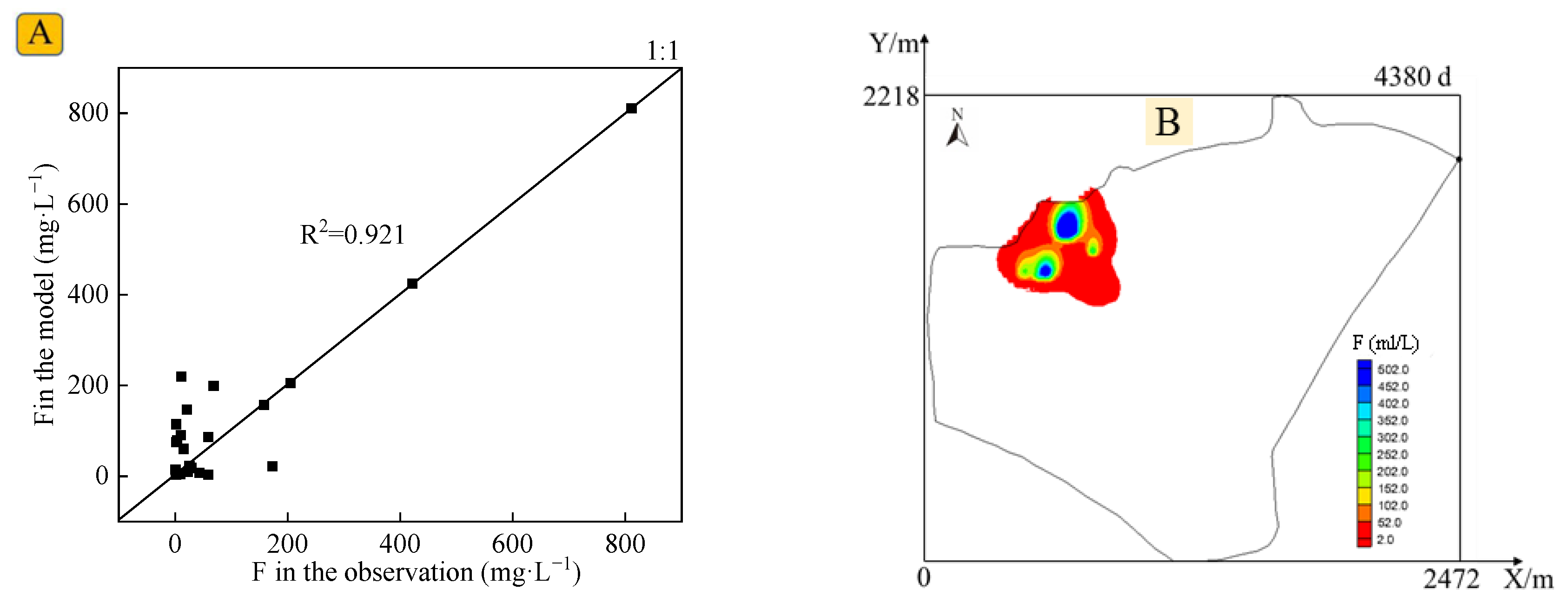
In this study, the solute transport model was used to perform inverse determination of the pollution source intensities using the observed groundwater hydrochemical characteristics over 4380 days (Figure 4). The fluoride release intensities from the phosphogypsum to groundwater were classified according to the observed fluoride concentrations. The intensity classes considered were as follows: pollution source was strong (S1 = 439 mg/d), pollution source was strong (S2 = 1132 mg/d), pollution source was strong (S3 = 1330 mg/d), and high pollution source intensity (S4 = 1600 mg/d). The intensity of the remaining pollution source from the phosphogypsum storage yard was considered strong (S5 = 2 mg/d). The pollution source intensity following the removal of surface phosphogypsum from the yard on day 4380 was calculated as 20%. In addition, based on the observed concentration and migration distribution of the fluoride, and referring to the relationship between the longitudinal dispersion and observation scale in the study area [29], the longitudinal dispersion and transverse dispersity to longitudinal dispersion ratio were determined to be 15 m and 0.8, respectively.

3.3. Sensitivity Analysis

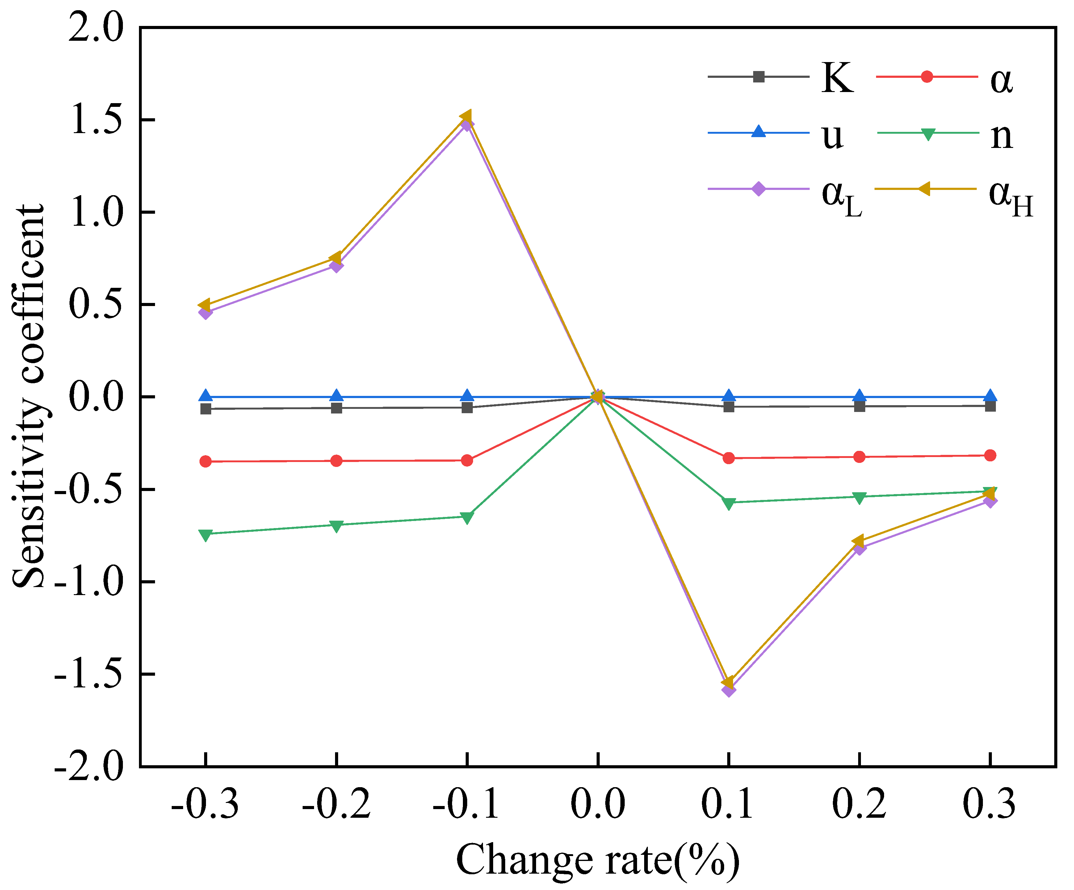
Hydrogeological parameters can exhibit different effects on fluoride transport model outputs. In this study, we assessed the effects of different hydrogeological parameters on the simulated solute transport using sensitivity analysis. These parameters included the permeability coefficient (K), precipitation recharge rate (α), water supply degree (u), porosity (n), longitudinal dispersity (αL), and transverse dispersity (αH). Each of the parameters were adjusted by ±10, ±20, and ±30%. Only one parameter was adjusted in each simulation, while the remaining parameters remained unchanged. The output fluoride concentrations were obtained by introducing them into the model. The parameter sensitivity of each groundwater monitoring well was calculated using Equation (5). The obtained values were averaged to determine the relative sensitivity of each hydrogeological parameter. The obtained sensitivity results of the hydrogeological parameters are shown in Figure 5.
The K, α, u, n, αL, and αH sensitivity coefficient ranges were −6.40 × 10⁻²–0, −0.35–0, −9.66 × 10⁻¹⁰–9.66 × 10⁻¹⁰, −0.74–0, −1.59–1.48, and −1.55–1.52, respectively. These findings indicate that αL and αH were the factors with the most influence on the groundwater fluoride concentrations, while the sensitivities of the other parameters can be ignored. Therefore, αL and αH parameters were used as random variables, while the remaining variables were considered deterministic variables. In addition, the Latin hypercube sampling method was used for sampling.

3.4. BPNN-Based Alternative Model

The Latin hypercube sampling method was used to randomly sample the pollution source intensity, as well as the αL and αH variation ranges of four main phosphogypsum accumulations. The number of training samples used in the BPNN-based alternative model was not less than 28. This value was calculated using the following formula [30]: (N + 1)(N + 2)/2, where N is the input vector dimension of the alternative model (N = 6). Although the increase in the number of training samples can improve the simulation accuracy of the BPNN-based alternative model, it may increase the computational load. In this study, we extracted 100 groups of training sampling, and then we randomly combined all the sampling results to obtain 100 input datasets. The parameter intervals of the sampling parameters and their distribution probabilities are reported in Table 3.
The six-dimensional data of the intensities, αL, and αH of the above four pollution sources were used as inputs in the groundwater solute transport model. The model was used to solve the pollute of the 26 groundwater monitoring wells in the entire area over the 4380- to 8030-day period, with a 1-year interval. The observed groundwater fluoride concentrations at each monitoring well over a 10-year period were used as output values of the sample. We selected 80 and 20 groups of data as training and testing datasets, respectively. The structure and parameters of the BPNN algorithm were optimized in this study through the training and testing processes. To evaluate the accuracy of the BPNN-based alternative model, the mean squared error (MSE) and coefficient of determination (R2) were computed using the following equations:
M S E = i = 1 n ( y i   y i ) 2 n
R 2 = 1 i = 1 n ( y i y i ) 2 i = 1 n ( y i y ¯ ) 2
where n is the number of the sample groups; yi is the predicted groundwater fluoride concentration by the simulation model; y i is the predicted groundwater fluoride concentration by the BPNN-based alternative model; y ¯ is the average predicted groundwater fluoride concentration output by the simulation model.
The number of hidden layer nodes can affect the performance of the BPNN-based alternative model. Indeed, a small number of the hidden layer nodes can negatively influence the training process of the network. On the other hand, a high number of nodes can reduce systematic errors, but overfitting may occur [31,32]. In this study, the number of the hidden layer nodes ranged from six to twenty-six. In addition, each node was run 10 times before calculating the average error of the neural network model in predicting the groundwater fluoride concentration (Figure 6A). The best fit and highest prediction accuracy of the alternative model were obtained at several hidden layer nodes of 15. The predicted groundwater fluoride concentrations by the BPNN-based alternative model were compared with those obtained using the groundwater transport model in the training and testing steps. According to the obtained results, most of the data points were distributed around the 1:1 regression line, resulting in R2 and Mean Squared Error (MSE) values of 0.999 and 0.079 mol/L, respectively (Figure 6B). These results demonstrate the high prediction performance of the BPNN-based alternative and groundwater fluoride transport models. Therefore, the BPNN-based alternative model can replace the groundwater fluoride transport model.

3.5. Optimization Model

3.5.1. Model Construction and Solution

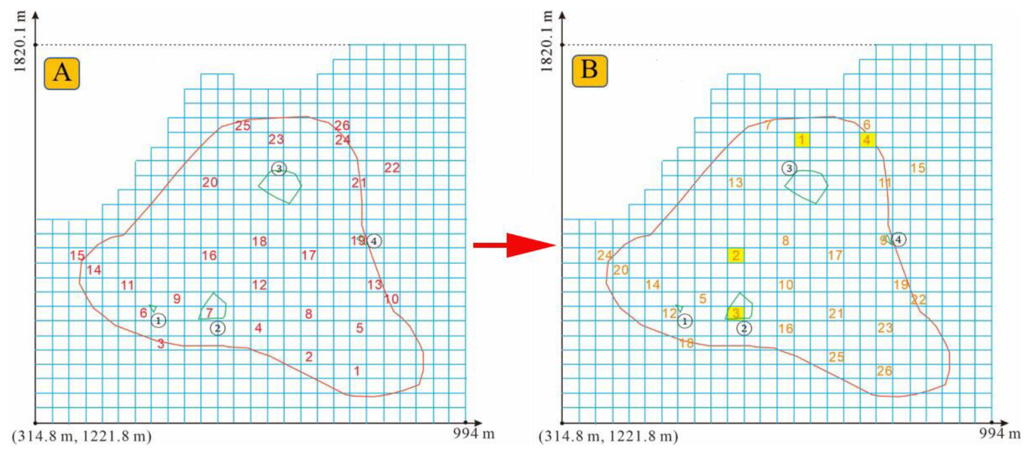
The optimal layout scheme under different groundwater monitoring wells was obtained using the operational optimization model (Figure 7). The groundwater monitoring wells were reordered based on the maximum groundwater fluoride concentration to determine the most representative groundwater wells. The smaller the number, the greater the concentration value. In addition, the number of groundwater monitoring wells was determined based on monitoring-related costs to determine the optimal layout scheme. In total, four groundwater monitoring wells were selected, namely no. 23, no. 16, no. 7, and no. 24.

3.5.2. Fluoride Concentration in the Groundwater Monitoring Wells

Statistical analysis was performed on the 1000 groups of the groundwater fluoride concentrations obtained using the Monte Carlo random simulations over the 10-year period and for the four selected monitoring wells. The obtained results are shown in Figure 8. The fluoride concentration ranges at monitoring wells no. 7, 16, 23, and 24 were 91.82–178.52, 165.36–311.22, 211.96–402.35, and 119.39–205.07 mg/L, with average concentrations of 134.65, 226.43, 301.47, and 164.88 mg/L, respectively. These results indicate that the most serious fluoride pollution was at observation well no. 23. This finding can be explained by the fact that a serious pollution source was located at monitoring well no. 3, resulting in the continuous accumulation of fluoride at monitoring well no. 23, downstream of the groundwater flow. Groundwater monitoring well no. 24 was located downstream of the groundwater flow from monitoring wells no. 16 and no. 7; however, groundwater monitoring wells no. 16 and no. 7 were closer to a pollution source at well no. 2, resulting in substantially higher groundwater fluoride concentrations. Therefore, there were high groundwater pollution levels in the intermediate area between groundwater monitoring wells no. 2 and no. 3. The standard deviation values of the groundwater fluoride concentrations at monitoring wells no. 7, 16, 23, and 24 were 14.24, 23.45, 30.81, and 13.64 mol/L, respectively, indicating great temporal variation in the fluoride concentration at well no. 23 under high pollution source intensities. In order to meet the pollution assessment requirements, the fluoride concentration ranges were determined under different confidence levels. The fluoride concentration ranges at the 95% confidence level at monitoring wells no. 7, 16, 23, and 24 were 133.76–135.53, 224.97–227.88, 299.56–303.39, and 164.03–165.72 mg/L, respectively. On the other hand, the fluoride concentration ranges at the 50% confidence level at monitoring wells no. 7, 16, 23, and 24 were 134.34–134.95, 225.93–226.93, 300.82–302.13, and 164.59–165.17 mg/L, respectively. These findings indicate that the groundwater fluoride concentration range slightly increased with an increase in the confidence level. Pollutant concentration ranges at different confidence levels can be determined according to actual requirements.

3.5.3. Test of the Optimization Results

The optimization principle of the monitoring well layout was to select the monitoring wells with the highest total fluoride count groundwater concentration over the total monitoring period. In order to further test the optimization results of the monitoring wells in each period, the fluoride pollution degrees were calculated. In this study, we determined whether the groundwater system was polluted by fluoride based on the lower limit of the Class Ⅳ fluoride concentration standard of 2 mg/L. Due to the high initial pollution source intensity in the study area, the groundwater fluoride concentration at the site exceeded the corresponding standard, making it difficult to test and evaluate the effect. Therefore, the S5 strong pollution source intensity was set at 0 mg/L, while the remaining pollution intensities, namely S1, S2, S3, and S4, were randomly combined to discuss four scenarios, as follows: (1) 13.9, 83.2, 103, and 130 mg/L; (2) 35, 100, 56, and 88 mg/L; (3) 100, 25, 15, and 43 mg/L; and (4) 42, 34, 28, and 46 mg/L. On the other hand, the hydrogeological conditions and monitoring times remained unchanged.
The fluoride contamination rates were calculated using the following equation:
p = j h i n y i , j n × h × 100 % ,           y i , j 0,1
where yi and yj denote the decision variables. A value of one was attributed to monitoring well j with a groundwater fluoride concentration higher than 2 mg/L at time t. Otherwise, the attributed value was set to zero.
The fluoride pollution rates of the random and optimized layout schemes under the different scenarios were further compared in this study (Table 4). It was found that the fluoride pollution rate of the optimized layout scheme reached 98.44% in each period, which was substantially higher than that of the random layout scheme. These results indicate that the monitoring well layout scheme obtained by solving the optimized model could not only monitor the highly polluted area at the local scale, but also monitor the area of groundwater highly polluted by fluoride at the site. Furthermore, it can also efficiently determine the groundwater fluoride contamination rates.

4. Conclusions

The groundwater fluoride concentrations obtained using the BPNN-based alternative model exhibited good fit with those derived from the groundwater solute transport model in the study area. The established BPNN-based alternative model was beneficial for reducing the computational load of the monitoring well network optimization design. The optimization model established by coupling the 0–1 integer programming with the solute transport simulation models selected the most representative monitoring wells from the existing wells, efficiently providing dynamic migration information of the pollution plumes and improving the monitoring well network scheme under the uncertainties of hydrogeological parameters and pollution source release intensities. Compared with the random deployment plan, the optimized deployment plan achieved accurate monitoring of the temporal groundwater fluoride pollution rates, which can comprehensively and effectively assessed the pollution degrees at the local scale, thus ensuring the effective remediation of groundwater pollution. This finding indicates that the groundwater monitoring wells selected using this method can not only efficiently capture dynamic migration information about the fluoride pollution plumes in the groundwater system but also accurately determine the temporal fluoride pollution levels, providing a reference for groundwater pollution remediation.

Author Contributions

H.W., R.Y. and X.H. wrote the paper; B.W. conceived and designed the experiments; X.Z. and C.Z. analyzed the data; and Z.H. and Y.F. performed the experiments and collected the data. All authors have read and agreed to the published version of the manuscript.

Funding

This research was funded by NSFC—the National Natural Science Foundation of China (No. 42377068).

Institutional Review Board Statement

Not applicable.

Informed Consent Statement

Not applicable.

Data Availability Statement

The data that support the findings of this study are available upon request from the authors.

Conflicts of Interest

Author Heng Wang was employed by the company Hefei East New Center Construction Investment Co. Ltd. The remaining authors declare that the research was conducted in the absence of any commercial or financial relationships that could be construed as a potential conflict of interest.

References

  1. Wan, T.; Bai, Y.; Wang, T.; Wei, Z. BPNN-based optimal strategy for dynamic energy optimization with providing proper thermal comfort under the different outdoor air temperatures. Appl. Energy 2022, 313, 118899. [Google Scholar] [CrossRef]
  2. Durgut, P.G.; Ayvaz, M.T. A novel fully hybrid simulation-optimization approach for enhancing the calibration and verification performance of the TUW hydrological model. J. Hydrol. 2023, 617, 128976. [Google Scholar] [CrossRef]
  3. Gamage, R.W.; Hettikankanange, P.M.; Lyman, K.D.; Austin, D.E.; Taylor, N.R. Simplified coaxial ion trap: Simulation-based geometry optimization, unidirectional ejection, and trapping conditions. Int. J. Mass Spectrom. 2022, 474, 116801. [Google Scholar] [CrossRef]
  4. Suthar, D.; Dhaka, M.S. Numerical simulation of CdSe/ZnTe thin film solar cells by SCAPS-1D: Optimization of absorber layer thickness. Solid State Commun. 2023, 371, 115264. [Google Scholar]
  5. Wang, Y.; Guo, X.; Yin, H.; Zhang, W.; Li, Q. Spatially distributed footprint families-based simulation-optimization approach for agricultural-ecological resources management under uncertainty. J. Hydrol. 2022, 613, 128319. [Google Scholar] [CrossRef]
  6. Wang, W.; Li, G.; Ye, J.; Li, G.; Tang, Y.; Fang, S. Optimization of Preparation of Cerium-loaded Intercalated Bentonite by Response Surface Method and Genetic Algorithm-back Propagation Neural Network and Its Application in Simultaneous Removal of Ammonia Nitrogen and Phosphorus. Chem. Lett. 2022, 51, 886–890. [Google Scholar] [CrossRef]
  7. Wang, Z.; Yang, Y.; Wu, J.; Sun, X.; Lin, J.; Wu, J. Multi-objective optimization of the coastal groundwater abstraction for striking the balance among conflicts of resource-environment-economy in Longkou City, China. Water Res. 2022, 211, 118045. [Google Scholar] [CrossRef]
  8. Van Thieu, N.; Barma, S.D.; Van Lam, T.; Kisi, O.; Mahesha, A. Groundwater level modeling using Augmented Artificial Ecosystem Optimization. J. Hydrol. 2022, 617, 129034. [Google Scholar] [CrossRef]
  9. Zhu, Z.; Li, Y.; Sun, Y.; Liu, Z.; Zhang, C. A Decision Support Framework for Pollution Source Detection via Coupled Forward-Inverse Optimization and Multi-Information Fusion. Water Resour. Res. 2023, 59, e2022WR032866. [Google Scholar] [CrossRef]
  10. Akbari, F.; Shourian, M.; Moridi, A. Assessment of the climate change impacts on the watershed-scale optimal crop pattern using a surface-groundwater interaction hydro-agronomic model. Agric. Water Manag. 2022, 265, 107508. [Google Scholar] [CrossRef]
  11. Anshuman, A.; Eldho, T.I. Entity aware sequence to sequence learning using LSTMs for estimation of groundwater contamination release history and transport parameters. J. Hydrol. 2022, 608, 127662. [Google Scholar] [CrossRef]
  12. Huang, J.J.; Xiao, M.; Li, Y.; Yan, R.; Zhang, Q.; Sun, Y.; Zhao, T. The optimization of Low Impact Development placement considering life cycle cost using Genetic Algorithm. J. Environ. Manag. 2022, 309, 114700. [Google Scholar] [CrossRef]
  13. Kumar, H.; Zhu, T.; Sankarasubramanian, A. Understanding the Food-Energy-Water Nexus in Mixed Irrigation Regimes Using a Regional Hydroeconomic Optimization Modeling Framework. Water Resour. Res. 2023, 59, e2022WR033691. [Google Scholar] [CrossRef]
  14. Kourakos, G.; Brunetti, G.; Bigelow, D.P.; Wallander, S.; Dahlke, H.E. Optimizing Managed Aquifer Recharge Locations in California’s Central Valley Using an Evolutionary Multi-Objective Genetic Algorithm Coupled With a Hydrological Simulation Model. Water Resour. Res. 2023, 59, e2022WR034129. [Google Scholar] [CrossRef]
  15. Li, W.; Nzeribe, B.N.; Liu, G.R.; Yao, G.; Crimi, M.; Rubasinghe, K.; Divine, C.; Mcdonough, J.; Wang, J. Modeling, simulation and analysis of groundwater flow captured by the horizontal reactive media well using the cell-based smoothed radial point interpolation method. Adv. Water Resour. 2022, 160, 104089. [Google Scholar] [CrossRef]
  16. Maurício, D.M.; Athayde, G.B.; Fan, F.M.; Garcia, L.H.; Athayde, C.d.V.M. Monitoring groundwater storage in a fractured volcanic aquifer system. Environ. Monit. Assess. 2023, 195, 385. [Google Scholar]
  17. Katpatal, Y.B.; Singh, C.K. Conjunctive use of flow modelling, entropy, and gis to design the groundwater monitoring network in the complex aquifer system. Int. J. Hydrol. Sci. Technol. 2023, 15, 78–96. [Google Scholar] [CrossRef]
  18. Fan, Y.; Lu, W.X.; Miao, T.S.; An, Y.K.; Li, J.H.; Luo, J.N. Optimal design of groundwater pollution monitoring network based on the SVR surrogate model under uncertainty. Environ. Sci. Pollut. Res. 2020, 27, 24090–24102. [Google Scholar] [CrossRef]
  19. Chen, R.J.; Tsay, Y.S.; Ni, S.W. An integrated framework for multi-objective optimization of building performance: Carbon emissions, thermal comfort, and global cost. J. Clean. Prod. 2022, 359, 131978. [Google Scholar] [CrossRef]
  20. Farlin, J.; Galle, T.; Pittois, D.; Bayerle, M.; Schaul, T. Groundwater quality monitoring network design and optimisation based on measured contaminant concentration and taking solute transit time into account. J. Hydrol. 2019, 573, 516–523. [Google Scholar] [CrossRef]
  21. Liu, Z.; Wang, X.; Jia, G.; Jiang, J.; Liao, B. Introduction of broadleaf tree species can promote the resource use efficiency and gross primary productivity of pure forests. Plant Cell Environ. 2024, 1–13. [Google Scholar] [CrossRef]
  22. Liu, Z.Q.; Wei, Z.J.; Jiang. J.; Yu, X.X. Adaptability of tree water use to elevation changes: A case study of a mixed forest in Northern China. J. Hydrol. 2022, 613, 128407. [Google Scholar] [CrossRef]
  23. Fan, Y.; Lu, W.X.; Miao, T.S.; Li, J.H.; Lin, J. Multi objective optimization of the groundwater exploitation layout in coastal areas based on multiple surrogate models. Environ. Sci. Pollut. Res. 2020, 27, 19561–19576. [Google Scholar] [CrossRef]
  24. Grbcic, L.; Lucin, I.; Kranjcevic, L.; Druzeta, S. Water supply network pollution source identification by random forest algorithm. J. Hydroinformatics 2020, 22, 1521–1535. [Google Scholar] [CrossRef]
  25. Reuss, M.; Oswald, S.E.; Kumke, M.M.U. Optical In Situ Monitoring of Acid Mine Drainage Remediation: Laboratory and Model Investigation. Ground Water Monit. Remediat. 2023, 43, 67–81. [Google Scholar] [CrossRef]
  26. Jordan, M.I.; Mitchell, T.M. Machine learning: Trends, perspectives, and prospects. Science 2015, 349, 255–260. [Google Scholar] [CrossRef]
  27. Xiong, Y.; Luo, J.N.; Liu, X.; Liu, Y.; Xin, X.; Wang, S.Y. Machine learning-based optimal design of groundwater pollution monitoring network. Environ. Res. 2022, 211, 113022. [Google Scholar] [CrossRef]
  28. Qiu, R.J.; Wang, Y.K.; Wang, D.; Qiu, W.J.; Wu, J.C.; Tao, Y.W. Water temperature forecasting based on modified artificial neural network methods: Two cases of the Yangtze River. Sci. Total Environ. 2020, 737, 139729. [Google Scholar] [CrossRef]
  29. Golden, H.E.; Evenson, G.R.; Christensen, J.R.; Lane, C.R. Advancing Watershed Legacy Nitrogen Modeling to Improve Global Water Quality. Environ. Sci. Technol. 2023, 57, 2691–2697. [Google Scholar] [CrossRef]
  30. Taupega-Satau, S.; Amosa, P.; Leauga, A.; Nunufolau, J.; Yan, T.V.N. Macroinvertebrate Community Index (MCI) and Quantitative Macroinvertebrate Community Index (QMCI) Analysis: A Comparative Study between Le Afe and Mulivaifagatoloa Rivers, Upolu Island, Samoa. J. Geosci. Environ. Prot. 2024, 12, 149–167. [Google Scholar] [CrossRef]
  31. Roukerd, F.R.; Rajabi, M.M. Anomaly detection in groundwater monitoring data using LSTM-Autoencoder neural networks. Environ. Monit. Assess. 2024, 196, 692. [Google Scholar] [CrossRef]
  32. Zhang, S.M.; Wang, X.D.; Huang, Z.W.; Bao, Y.T.; Jiang, J.; Liu, Z.Q. Quercus acutissima exhibits more adaptable water uptake patterns in response to seasonal changes compared to Pinus massoniana. For. Ecosyst. 2025, 12, 2197–5620. [Google Scholar] [CrossRef]
Figure 1. Overview of the study area (A) and geographic locations of the observation wells (B).
Water 16 02965 g001
Figure 2. Structure of the backpropagation neural network algorithm.
Water 16 02965 g002
Figure 3. Comparison between the measured and simulated groundwater levels (A) and spatial distribution of the groundwater flow field (B).
Water 16 02965 g003
Figure 4. Inverse determination of the pollution source release intensities (A) and fluoride (F) migration results (B).
Water 16 02965 g004
Figure 5. Sensitivity analysis results of the hydrogeological parameters.
Water 16 02965 g005
Figure 6. Results of the BPNN-based alternative and transport simulation models; relationship between the hidden layer nodes and network errors (A); (B) fitting result between the predicted groundwater fluoride concentrations obtained using the BPNN-based alternative and transport simulation models.
Water 16 02965 g006
Figure 7. Optimization layout scheme for groundwater monitoring network in the study area. The spatial distribution of the total (A) and selected (B) groundwater monitoring wells. The yellow points were the sampling repetition point.
Water 16 02965 g007
Figure 8. Cumulative groundwater fluoride concentrations at the selected groundwater monitoring wells (A) and their corresponding statistical analysis (B).
Water 16 02965 g008
Table 1. Hydrochemical characteristics and quality assessment of groundwater in the phosphogypsum storage field.
Test ItemsDetection LimitMinimumMaximumGroundwater Class IVWater Quality Assessment score
Arsenic (μg/L)0.30.416905033.8
Cadmium (mg/L)0.00500.0230.012.3
Total hardness (calculated as CaCO3) (mg/L)512228606504.4
Total dissolved solids (mg/L)41230870020004.35
Volatile phenol (mg/L)0.000300.01750.011.748
Dissolved oxygen (mg/L)0.51.71031010.3
Ammonium nitrogen (mg/L)0.0250.6882.061.51.372
Sulfate (mg/L)0.018151380035010.857
Chloride (mg/L)0.0070.009883502.822
Fluoride (mg/L)0.0060.508112405.475
The evaluation score was calculated as the ratio of the highest groundwater parameter concentration to the Class IV groundwater quality standard used to assess the groundwater pollution level.
Table 2. Main aquifer parameters used in the groundwater flow model.
PartitionPermeability Coefficient (m/d)Precipitation Recharge Rate (m/d)Specific YieldPorosity
Western region0.88.0 × 10−50.020.25
Eastern region1.06.0 × 10−50.030.22
Table 3. Parameter ranges and their probability distributions.
Random VariablesProbability DistributionsAverage ValuesValue Ranges
S1 (mg/d)Normal distribution439307.3~570.7
S2 (mg/d)Normal distribution1132792.4~1471.6
S3 (mg/d)Normal distribution1330931~1729
S4 (mg/d)Normal distribution16001120~2080
Vertical dispersion αL (m)Lognormal distribution1510.5~19.5
Horizontal dispersion αH (m)Lognormal distribution128.4~15.6
S denotes high pollution source intensities.
Table 4. Groundwater fluoride pollution rates under the monitoring well layout scheme.
Integer Programming ModelNumbers of the Monitoring Wells Fluoride Pollution Rates (%)Average Pollution Rates (%)
Scenario 1Scenario 2Scenario 3Scenario 4
Optimization7, 16, 23, and 2410010093.7510098.44
Random 19, 12, 17, and 23757566.6772.9272.40
Random 24, 11, 19, and 2464.587560.4268.7567.19
Random 310, 14, 18, and 2041.6743.7529.1735.4237.50
Random 45, 16, 20, and 2666.6768.755056.2560.42
Disclaimer/Publisher’s Note: The statements, opinions and data contained in all publications are solely those of the individual author(s) and contributor(s) and not of MDPI and/or the editor(s). MDPI and/or the editor(s) disclaim responsibility for any injury to people or property resulting from any ideas, methods, instructions or products referred to in the content.