Abstract
The Ghrib Basin is currently encountering water-related challenges due to population growth and growing competition among water users. Therefore, assessing the current water situation is essential for the anticipation of future needs in the region. This paper assesses water demand and allocation strategies in the Ghrib Basin, Algeria, using the Water Evaluation and Planning (WEAP) system. The simulation is based on five scenarios: “Increase in population and agricultural activity”, “Improving agricultural activity”, “Minimum domestic consumption”, “Enhancing Water Resources”, and “Best practice”, (which is a combination of two scenarios, i.e., “Improving agricultural activity” and ”Minimum domestic consumption”). The simulation outcomes indicate that the “Best practice” scenario represents the most advantageous and beneficial scenario by which the problem of the unmet demand can be solved. The resulting simulations indicated the need for the employment of water-efficient irrigation systems as well as the encouragement of sustainable water use, such as drip irrigation, which necessitates coordinated efforts and particular infrastructural investments. The derived outcomes are highly convincing and have the potential to serve as a decision support system for the effective governance of water resources in the Ghrib Basin. The methodology utilized in this study has the potential to be implemented in any basin across the globe.
1. Introduction
The increase in water demand due to population growth, land use change, and climate change makes future water availability unpredictable [1], which has impacted many arid and semi-arid areas, including Algeria. In Algeria, water demand for domestic use, agriculture, and industry is increasing annually, which poses a significant challenge to the national development plans due to the multiplicity of needs and the vulnerability of the resource to climate change [2]. Since the beginning of the 2000s, the Algerian government has taken important measures to manage the situation of water scarcity that affected the country through the development of hydraulic infrastructures: dams, transfers, seawater desalination plants, and purification plants [3]. Generally, mastering water management is considered a critical goal in an effort for national development [4].
Many scholars have recommended the use of water management-related software for assessing water resources and needs. The Water Evaluation and Planning (WEAP) system, which was developed by the Stockholm Environment Institute [5,6], is an integrated water resource planning tool that provides a comprehensive, adaptive, and user-friendly policy analysis framework [7]. Integrated water management at the watershed level is a management approach that considers all activities that impact water resources within a watershed in a sustainable manner without compromising the viability of ecosystems [8]. WEAP is a practical instrument for water resource planning and policy analysis that combines water supply in the context of demand-side management, as well as water quality and ecosystem preservation and protection [9]. Demand-side concerns, such as water consumption patterns, equipment efficiency, reuse methods, pricing, and water allocation schemes, are treated with equal importance by the model alongside supply-side concerns, such as stream flow, groundwater supplies, reservoirs, and water transfers [10]. Several studies around the world have been conducted using WEAP. In Algeria, several studies have employed WEAP to examine critical issues such as the current and future water supply in the Seybouse River basin under changing climate scenarios [11]. Another study using the WEAP model focused on Strategic Decision-Making in Sustainable Water Management [12]. WEAP has been used to assess future water demand in Boumerzoug, in the upper sub-catchment of the Kébir-Rhumel basin [13]. In Syria, an estimation of water supply and demand by 2050 using the WEAP model was conducted [14]. In Somalia, WEAP was used for the assessment of the Streamflow and Evapotranspiration at Wabiga Juba Basin [15]. In the Mediterranean region and in arid and semi-arid climates such as Algeria, the WEAP model has been extensively utilized in various studies. For instance, to analyze water resources and their uses in the Oued Kébir Ouest watershed [16]. These studies demonstrate the valuable role of WEAP in assessing water management strategies in regions facing water scarcity challenges. The WEAP model is highly regarded for its ability to simulate water resource systems and support decision-making in water management. Studies have shown its effectiveness in analyzing scenarios, assessing climate change impacts, and aiding water allocation planning across different scales. Overall, it is a valuable tool for water resource management.
The Ghrib Basin in Algeria (a typical semi-arid Mediterranean basin) is facing major challenges in terms of water scarcity and water management due to the increasing demands from growing populations, urbanization, and agriculture practices [17]. The lack of proper water management infrastructure in the region is also exacerbating water-related problems and hindering efforts to address them. The region is under growing pressure to meet the water needs of its increasing population while also considering the preservation of the health of its ecosystems and safeguarding its water resources for future generations.
In this study, the main objective is to assess water demands, resources, and water resource allocation strategies in the Ghrib basin using the WEAP system. This involves considering different types of identified water demands (e.g., agricultural, domestic, industrial) and water resources in the study area. The goal is to develop water allocation strategies that optimize the use of available water resources and meet the various types of water demands in the Ghrib basin and to evaluate the balance between water supply and demand in the basin, taking into account potential socio-economic activities such as population growth projections, water availability, and water demand.
2. Materials and Methods
2.1. Study Area
The Ghrib Basin watershed is part of the Oued Cheliff Basin; Figure 1, which is located 100 km southwest of Algiers, between 2°25′ and 3°45′ east longitude and between 35°45′ and 36°00′ north altitude [18]. With an average altitude of 895 m, it drains an area of 1378.67 km2. The Ghrib flows over 79.9 km, following an orientation from southeast to west. The landform reaches an altitude of 1500 m, while the lowest point is at the outflow, with an altitude of 400 m [19]. The watershed of Ghrib is elongated in shape along the axis of the mainstream. The Wadi is a tributary of Oued Cheliff. The outlet is about 20 km to the southwest of Medea Wilaya [18]. The basin is characterized by an average maximum temperature of 29.04 °C recorded in August and an average minimum temperature of 6.73 °C recorded in January. The annual rainfall in the watershed varies between 300 and 500 mm/year, with the maximum precipitation occurring in November and December and the minimum in July and August; the watershed shape is the geometric configuration projected onto a horizontal plane [20]. It has a direct influence on the response time of the basin, which means the time taken for water to flow through the drainage network and consequently on the flood hydrograph [20]. The soils of the Cheliff Basin have a pH higher than 7, a presence of limestone accumulation horizons even when the bedrock is not carbonated, net claying, soluble salt levels, and the distribution of organic matter. The soils are composed of four groups: (a) Alluvial soils, which are less evolved and evenly distributed throughout the watershed. (b) Hydromorphic soils, which are widespread. (c) Saline soils have seasonal salt dynamics without leaching or surface concentration. However, in the case of sharp solonchak, salt accumulates on the surface, which can lead to wind erosion. (d) Automorphic soil type, which is brown in color [21]. The Ghrib Basin covers 15 communes in the Wilaya of Medea, with an estimated population of 167,065 people, according to the National Office of Statistics (ONS, 2023).
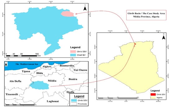
Figure 1.
The location of the study area.
2.2. Water Supply and Demand in the Ghrib Basin
Based on the National Agency for Integrated Water Resources Management [17], Table 1 presents the water situation in the study area in 2022.

Table 1.
Water situation in The Ghrib Basin [17].
The Ghrib dam has a storage capacity of 280 Million Cubic Meter (MCM), complemented by 560 operational groundwater wells. The total annual water availability within the Ghrib Basin is 9.09 MCM/year, with a 95% coverage of water distribution networks. The annual water allocation includes 1.2 MCM for domestic use, 7.5 MCM/year for agricultural irrigation, and 0.39 MCM/year for industrial activities. However, the annual water demand exceeds the supply, with domestic consumption requiring 3.6 MCM/year, industrial demand at 0.43 MCM/year, and agricultural demand at 7.8 MCM/year. The basin encompasses 3603 hectares of agricultural land, of which 1441 hectares are under irrigation.
The water supply networks cover approximately 95% of the population, providing widespread access to clean water. Moreover, the water supply connection rate stands at an impressive 95% [22]. In the basin province (Medea) the drinking water supply is provided by rainwater storage tanks [22]. Agriculture is an important economic activity in the Ghrib Basin, with a total agricultural area of 3603 hectares [17]. Farmers in the region produce a wide variety of irrigated crops, including vegetables, arboriculture, and cereals [23]. The farmers use a variety of irrigation methods, such as gravity irrigation, spray irrigation, drip irrigation, and dry irrigation, based on the region, with an irrigated area covering 1441 hectares [15]. The industrial zone in Ksar El Boukhari province is a thriving area that provides extensive space for a diverse range of manufacturing and production facilities. This industrial zone comprises 85 individual lots, offering ample opportunities for businesses to set up their operations [24]. One crucial factor for industrial development is the availability of water resources. The industrial zone in Ksar El Boukhari benefits from a water supply of 0.39 MCM/year to meet its operational needs [2].
2.3. Water Resources of Ghrib Basin
2.3.1. Surface Water Resources
There are several streams and one large dam, the Ghrib Dam, in the basin (see Figure 2). The dam was completed in 1939 with an initial capacity of 280 MCM. It retains the waters of the Oued Cheliff and provides water to the Ghrib Basin. The dam is an important water reservoir for irrigation, the supply of drinking water, and the water supply for industries, as well as for the city of Medea [25].
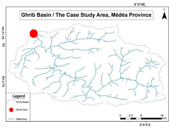
Figure 2.
Map of streams in the Ghrib Basin.
The amount of water flowing into the dam varies depending on the hydrological year. In dry years, such as 2016, it was only 24 MCM, while in wet years, such as 2018, it was 178.5 MCM [19]. Drinking water withdrawals in 2015 were approximately 10 MCM. The total irrigation withdrawals at the dam between 2015 and 2018 were about 162 MCM, with the highest withdrawal recorded in 2015 at 55 MCM, representing a 34% rate compared to other years, and a significant decrease in 2018 to 27 MCM [19].
Upstream of the Ghrib, the Oued Cheliff is regulated by the Boughzoul dam, which is located 20 km south of Boughari (Medea) and 110 km from the Ghrib [24]. The Boughzoul dam has a capacity of around 30 MCM and is designed to mitigate floods from the downstream Ghrib dam. The reservoir also acts as a decanter, limiting inflows to the Ghrib reservoir.
2.3.2. Groundwater Resources
The total groundwater resources currently known amount to 560 wells, which are replenished annually by rainwater seeping into the ground layers [15]. The Wilaya is facing overexploitation of its groundwater resources due to heavy reliance on meeting domestic and industrial irrigation needs, as opposed to limited surface water mobilization, resulting in significant pressure and exploitation [26]. The state has several water conditioning structures, including 560 wells primarily for drinking water, with springs contributing approximately 30% to 40% of the water supply [17].
2.3.3. Treated Wastewater
The Medea wastewater treatment plant is located 7 km south of the city of Medea. Commissioned in 2007 and operated by the National Sanitation Board, it treats activated sludge domestic wastewater from the city of Medea and the surrounding area. The main objective of this plant is to minimize the pollutant load of domestic wastewater to discharge treated water that is compatible with desirable quality and within ideal standards. It has never been used for irrigation and remains unused because the treated wastewater can constitute a risk in agriculture as it does not fulfill water quality standards due to insufficient microbial, chemical, and nutrient removal. Using treated wastewater for agricultural irrigation can be cost-effective, but if the water quality does not satisfy safety standards, crops may get contaminated with zoonotic parasites, leading to human diseases. Ensuring safe use necessitates major investment in new treatment technology, continual monitoring, and stringent regulation compliance. While it provides long-term water savings, its viability is dependent on the ability to invest in necessary infrastructure and maintain public health [27,28].
2.4. Data Used
The data utilized in this study, collected between 2022 and 2023, were sourced from various references, as detailed in Table 2, Table 3, Table 4 and Table 5.

Table 2.
Data used and their sources.

Table 3.
Domestic water demand (year 2022) (m3) [17].

Table 4.
Agricultural water consumption (m3/year) [15].

Table 5.
The population of the 15 municipalities in the Ghrib watershed.
There are 15 municipalities and 06 Diaras in the Ghrib Basin. The details of the water supply for different municipalities and Diara by different sectors for 2022 are mentioned in Table 3 and Table 4.
The total water supply for agriculture water use for the Ghrib Basin in 2022 is 7.5 MCM/year; however, the estimated water demand in agriculture is approximately 7.8 MCM/year.
The total water supply for domestic water use for the Ghrib Basin in 2022 is about 1.2 MCM/year. However, the estimated water demand is approximately 3.6 MCM /year. Therefore, there is a significant shortage of water supply in the range of 2.4 MCM/year [17].
The industrial zone, exclusively located within the Ksar El Boukhari municipality, comprises 85 strategically allocated lots. The industrial sector here consumes a substantial 0.39 MCM of water annually. This region hosts a diverse array of industries, including dairy production, plastics, chemicals, rubber and glass manufacturing, plastic hardware and building components, iron and steel production, metallurgy, mechanical engineering, electrical and electronic industries, and metal building panel fabrication [27].
2.5. Modeling of the Ghrib Basin
This research employs the Water Evaluation And Planning (WEAP) model to examine the water resources in the Ghrib Basin and find the most effective water allocation options. The WEAP model was selected in this study because it supports planners in forecasting demand and supply structures under various assumptions and management practices and helps in developing resource management policies to meet future demands and solve allocation problems [29].
This procedure will result in a full knowledge of the important issues that must be addressed when designing plans for the allocation of water resources in the Ghrib Basin. Furthermore, the simulation of the WEAP model will be used to balance the conflicting needs of various water users and to guarantee that water supplies are allocated in a sustainable and equitable way.
WEAP database: the National Agency for Integrated Water Supplies Management in Algiers provided data on water supplies and demand in the Ghrib Basin.
Figure 3 represents the methodological steps. This work involves first collecting the data and creating a study area map using ArcGIS (step 1), which serves as a background for simulating various elements like urban areas, rivers, and agricultural sites (step 2) [5,6]. Key assumptions and references are then established to enable the software to simulate water demand and supply [30]. Five scenarios are proposed (details below), typically starting with a current account year as a reference scenario followed by different scenarios to assess future socio-economic and climatic impacts (step 3). Finally, results are presented in graphs or tables, comparing the reference and different scenarios (step 4).
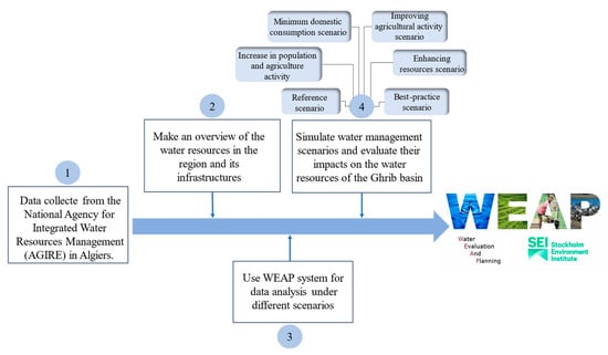
Figure 3.
WEAP model methodology flow diagram.
2.5.1. WEAP Model
The WEAP system (http://www.weap21.org/, accessed on 1 October 2024), developed by the Stockholm Environment Institute’s U.S. Centre, was selected for the current application because of its strengths: (i) it is a generic, integrated water resource planning software tool that provides a comprehensive, flexible, and user-friendly framework for the development of water balances, scenario generation, planning, and policy analyses [31].
WEAP is a PC-based simulation tool for surface and groundwater resources that operates on water balance accounting principles. It can evaluate different scenarios of supply and demand conditions. This allows for the projection of changes in water demand, supply, and pollution over a long-term planning period, aiding in the development of adaptive management strategies [32]. Running the WEAP requires the input of a large database for every element in the network. The data structure and level of detail may be easily customized to meet the requirements of a particular analysis and to reflect the limits imposed when data are limited [33].
Several studies around the world have been conducted through WEAP. Ref. [34] estimated water supply and demand in Syria by 2050 using the WEAP model. In Greece, WEAP has been applied in the Ali Efenti watershed to design water efficiency measures to address water scarcity due to rapidly increasing water withdrawals. In Nepal, water management strategies have been applied in the Kathmandu Valley to meet water security [34]. A study conducted using the WEAP model on water resources and their usage in the Oued Kébir Ouest watershed in Algeria revealed potential future water stress. The study examined the confrontation of future water supply and demand under different scenarios and highlighted the likelihood of water shortages affecting the area in the future [16].
2.5.2. WEAP Model Setup
The typical scenario in the WEAP model consists of three steps: (1) a current account year is chosen as the model’s reference year, with data or a period added; (2) a reference scenario is established based on the current account; then, (3) the probable evolution of the system is simulated without interposition. Other scenarios are developed to assess the effects of socio-economic changes and climatic changes for the future year or project [3].
The model was initially set up using default parameters based on data availability. The calibration process involved iterative manual adjustments of the parameters, followed by a comparison of model outputs with observed data.
Calibration and validation of the models are necessary and used to ensure the quality and accuracy of the results; it involves improving reliability by modifying the parameters so that the simulated results correspond closely to the measured data [35,36]. The aim of calibration is to adjust the parameters so that the model solutions fit the observations in an optimal fashion. Model calibration was performed manually via trial and error.
The calibration of the WEAP model was performed using data from the year 2022 due to the availability of high-quality data from the region. The same types of data used for calibration were applied during validation, ensuring consistency in input data.
The current account (the base year chosen is 2022), which can be considered a calibration step in the development of the model, provides a snapshot of the current water demand, resources, and supplies for the system based on the data from this year allowed us to accurately reproduce the water situation of the basin this year using the WEAP model and subsequently observe, through scenarios over different time horizons, the state of water resource allocation for various uses. The calibration of the model, therefore, involves determining the unobserved parameters of the model (household, agricultural, and industrial unit consumption, distribution network losses, etc.). The model will be properly calibrated when these parameters are well-defined and calculated based on a quantitative study. The sum of the flows of incoming and outgoing streams at the demand sites must approach 0 to ensure a good calibration of our model.
For water supply and demand studies, we need to gather the following main data: the amount of domestic water used, the amount of water used for irrigation and industrial use, as well as the number of users. These essential data, covering water resources and the primary water users, allow us to create basic models for water management, prioritization, and demand allocation. Including data from other users, such as industrial users, makes the modeling more realistic [10].
The results will be shown in the form of a graph and/or table. Two sets of results will be compared: one for the reference year and one for the scenario year to facilitate comprehensive analysis. WEAP is a sophisticated tool designed for integrated water resources planning, enabling users to model various scenarios and assess their impacts on water availability, demand, and quality. By leveraging WEAP’s capabilities, the analysis will involve comparing key metrics such as water supply, consumption patterns, and environmental impacts between the reference and scenario years. The graphical representations will illustrate trends and variations over time, while the tables will provide detailed numerical comparisons, facilitating a clearer understanding of the potential effects of different management strategies and policy decisions [10].
2.5.3. Management Alternatives and Scenario Analysis
In the context of water resources, scenarios involve various sets of assumptions, such as different operational policies, costs, and factors influencing water demand, water management strategies, alternative water sources, and hydrological conditions. These variables can change at different rates over the study’s planning period. Therefore, scenarios are grounded in actual conditions rather than being purely conceptualized by requirements engineers [36]. This method, known as scenario analysis, is particularly useful for modeling real-world problems where decisions depend on uncertain information represented as a range of possible outcomes [35]:
(1) The reference scenario reflects the current state and trend of water supplies and demand from the current year (2022) to 2052, with no influences from outside. The population is determined for the year of study by the expression generator program through the “Growth from” function, using the rate of increase of 1.8% and the year of the corresponding current population count. For the agriculture and industry sites, the growth rate is assigned as 1% [12]
(2) Increase in population and agriculture activities scenario, developed under the assumption that human needs will increase over time. It was designed to assess the impact of a 3% rapid population growth rate and a 1% increase in agricultural activity between 2022 and 2052 [12].
(3) Minimum domestic consumption scenario implements an estimated reduction of 30% in domestic water consumption with the promotion of efficient water use and avoiding water waste while keeping the growth of the population at the same level as the reference scenario at a 1.8% growth rate [12]. The agricultural and industrial water consumption was kept constant.
(4) Improving agricultural activity scenario. The objective of this scenario is to reduce agricultural water demand by reducing agricultural consumption. This improvement strategy is focused on hypotheses that involve the utilization of water-efficient systems, specifically new irrigation techniques. The usage of irrigation methods for cultivating varies within the agricultural lands of the Ghrib Basin, including gravity irrigation, spray irrigation, and drip irrigation. Gravity irrigation is the most common method on almost half of the agricultural lands, and as we know, this method consumes more water than the other methods. For that reason, the supposition of increasing the utilization of the drip irrigation method could reduce agricultural consumption and preserve better water consumption. Because of the increased utilization of drip irrigation methods, a part of the agricultural unit consumption from the reference scenario would be retained for agricultural activities. The reduction in water consumption allocated for the gravity method will lead to a significant 27.6% reduction in overall irrigation water usage by 2052, assuming drip irrigation will save 60% of the water used in gravity irrigation by 2052.
(5) Enhancing resources scenario. The objective is to improve the distribution and flow of water from the dam to the districts by increasing the flow. This scenario considers the maximum capacity of the dam’s supply with improved efficiency and a higher discharge. The current water supply from the dam to the districts in the basin falls short of meeting the demands of all the consumption sites. However, when there is a reduction in water losses in the pipelines and an improvement in the productivity efficiency of the dam, it can lead to an increase in the distribution flow rate.
(6) The best-practice scenario will combine the two scenarios of minimum domestic consumption and improving agricultural activity using the following two hypotheses:
- Decrease the domestic water consumption in the basin by a reduction of 30% with the promotion of efficient water use and avoiding water waste.
- Decrease agricultural water consumption by 27.6% in agricultural activities (increased utilization of drip irrigation methods).
3. Results and Discussion
3.1. Reference Scenario
The simulation illustrates that the total annual water demand in the Ghrib Basin for the three sectors (domestic, agriculture, and industry) will increase from 12.46 MCM in 2022 to 18.37 MCM in 2052, with an increase of 5.91 MCM (Figure 4). This rise in volume represents a 48% increase over the initial water demand. The increase in water demand is attributed to the rapid growth in population, expansion of agricultural lands, and increased production from industrial units across the districts within the basin. Starting at 7.68 million m3 in 2022 for agricultural water demand, it increased to 10.35 MCM by 2052. Water demand for the industry increased from 0.43 MCM in 2022 to 0.57 MCM in 2052.
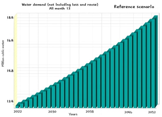
Figure 4.
Total annual water demand in the reference scenario (2022–2052).
On a monthly basis, the highest water demand was observed in July, reaching 1.48 MCM (Figure 5). This surge can be attributed to increased water consumption during the summer season, both for domestic use and agriculture, and reduced precipitation during the summer months (June, July, and August), in contrast to other months distinguished by the occurrence of precipitation.
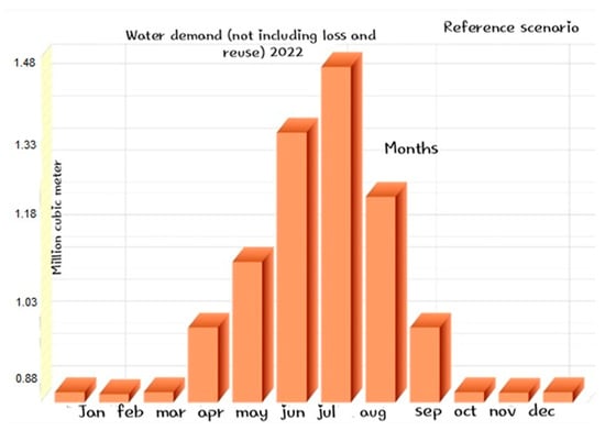
Figure 5.
Total average monthly water demand in 2022.
Higher summer temperatures cause more evaporation and plant transpiration, increasing the demand for irrigation and human consumption. This puts additional strain on hydraulic systems, necessitating optimal water distribution to fulfill increased demand.
Warm temperatures and longer daylight make June, July, and August optimal for crop development and seed germination; therefore, agricultural activity peaks during these months. Summer rainfall and irrigation help to keep crops hydrated, while planting now allows for timely harvesting. Furthermore, heat aids in the management of pests and diseases, resulting in increased water demand for irrigation during the summer months [17].
Given the growth rates of domestic, agricultural, industrial, and infrastructure demand sites, the volume of water required to satisfy sectoral needs must surpass its initial demand. Consequently, without intervention, there will be a deficit or unmet water demand. Figure 6 reveals that by the year 2038, the water imbalance will entail a difference of 10.5 MCM, with 5 MCM for domestic areas, 4.5 MCM attributed to agricultural needs, and 1 MCM for industrial purposes. The water deficit will rise up to 21 MCM by 2052, with 11 MCM for domestic areas, 8.5 MCM attributed to agricultural needs, and 1.5 MCM for industrial purposes. This situation poses a serious threat to the development of our basin region. As a result, scenarios and solutions should be proposed to compensate for this unmet water need.
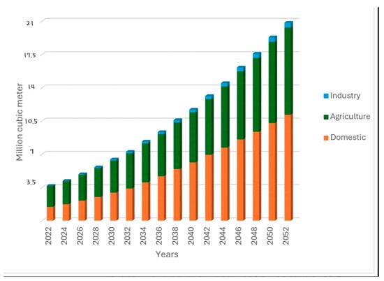
Figure 6.
Unmet demand in the basin—reference scenario (2022–2052).
3.2. Increase in Population and Agriculture Activities Scenario
Comparing the reference scenario and the scenario of increasing population and agriculture activity indicated an increase in the unmet demand, which might increase the unmet demand up to 10 MCM by 2052, as shown in Figure 7.
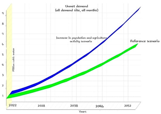
Figure 7.
Comparison between the unmet demand of the two scenarios: “reference scenario” and “increase in population and agriculture activities scenario” (2022–2052).
3.3. Minimum Domestic Consumption Scenario
The reduction in domestic consumption is projected to decrease water demand by approximately 2.07 MCM by the end of 2052. Thus, the unmet water demand will decrease from about 5.96 MCM in the reference scenario to 3.74 MCM in the minimum domestic consumption scenario as shown in Figure 8.
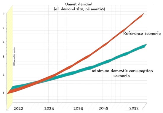
Figure 8.
Comparison between the unmet demand of the two scenarios: “reference scenario” and “minimum domestic consumption scenario” (2022–2052).
3.4. Improving Agricultural Activity Scenario
The reduction in water consumption allocated for the gravity method will lead to a significant 27.6% reduction in overall irrigation water usage by 2052, assuming drip irrigation will save 60% of the water used in gravity irrigation by 2052 (Figure 9).
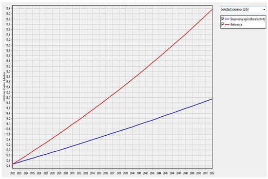
Figure 9.
Water demand for all demand sites in the two scenarios (reference, improving agricultural activity) (2022–2052).
In this scenario, the water demand for agriculture decreases significantly due to the advanced irrigation infrastructure. As a result, the demand for water in the basin will be reduced to about 3.41 MCM by the end of the period in 2052. This is estimated to decrease the water demand from an initial value of 18.37 MCM to 14.96 MCM by 2052.
By 2052, the unmet water demand will decrease from around 5.96 MCM in the reference scenario to 3.8 MCM in the improving agriculture activity scenario (Figure 10).
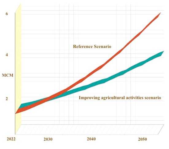
Figure 10.
Unmet demand for all sites for the reference and the improving agricultural activities scenarios.
3.5. Enhancing Resources Scenario
The current water supply from the dam to the districts in the basin falls short of meeting the demands of all the consumption sites. However, when there is a reduction in water losses in the pipelines and an improvement in the productivity efficiency of the dam, it can lead to an increase in the distribution flow rate. This approach has led to an extension in the unmet demand, resulting in a decrease in water demand from 5.96 MCM in the reference scenario to 3.34 MCM in the enhancing resources scenario by the end of 2052 (Figure 11).
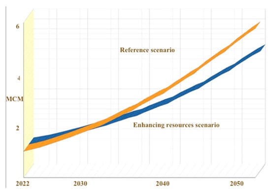
Figure 11.
Unmet demand for all sites for the reference and enhancing resources scenarios.
3.6. Best-Practice Scenario
In the best-practice scenario, the unmet demand decreases significantly, starting at 1.05 MCM in 2022 and nearly reaching zero by the end of the study year 2052. When comparing this outcome with the reference scenario, the substantial difference in unmet demand decreases due to the reduction in both domestic and agricultural water consumption. (Figure 12).
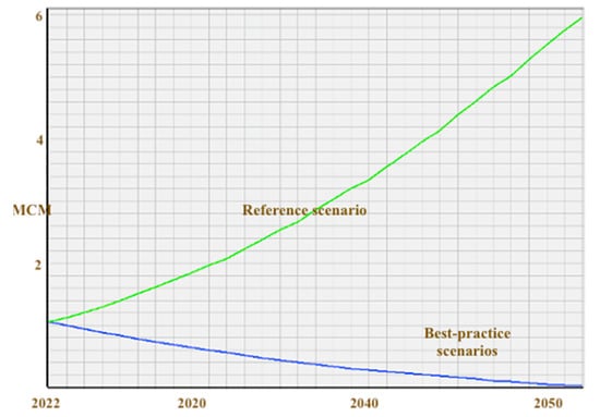
Figure 12.
Unmet demand for all sites in the reference and best-practice scenarios.
Figure 13 shows the simulation of the unmet demand of the six scenarios, which highlights the importance of new strategies aiming at increasing water production and encouraging local authorities and all stakeholders to make efforts to improve the efficiency of the water distribution network, install modern irrigation techniques, and promote water use efficiency.
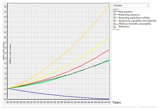
Figure 13.
Comparison of the unmet demand for all demand sites in all scenarios (2022–2052).
The WEAP system can assess the implications of various factors of change for the Ghrib Basin. This was conducted based on data corresponding to domestic, agricultural, and industrial water consumption during the year 2022. Using the reference year (2022) as a starting point, the WEAP model assisted us in selecting key reference assumptions and in choosing assumptions for each of the six simulated scenarios. These scenarios were tested to evaluate water availability for the period from 2022 to 2052. Each of these scenarios was created to identify the most efficient alternative water management scenario over a period of 30 years. These strategies aim to increase water production rates. At the same time, it aims to encourage public authorities to make efforts to improve the efficiency of the water distribution network. This includes the introduction of new irrigation techniques and the promotion of efficient water use while avoiding water waste.
In assessing the various scenarios aimed at optimizing water resource management in the Ghrib Basin, some scenarios are more favorable than others. Figure 13 illustrates that the “Best practice” scenario garnered a rating of very favorable. This approach involves an estimated substantial reduction of 27.6% in irrigation water requirements and a 30% decrease in domestic water allocation. Following closely is the “Improving agricultural activity” scenario, which is also regarded as very favorable, primarily due to its emphasis on a 27.6% reduction in irrigation water demand. Furthermore, the “Enhancing resources” scenario, focusing on minimizing losses and enhancing dam productivity, is considered less favorable. The “Minimum domestic consumption” scenario, seeking a 30% cut in domestic water allocation, also receives a less favorable rating. Lastly, the “Increase in population and agriculture activity” scenario, characterized by rapid population growth at a 3% rate and a 1% increase in agricultural activity, is rated as unfavorable due to the substantial challenges it presents for effective water resource management in the basin.
4. Conclusions
The WEAP System has been used to simulate current water balances and evaluate water management strategies in the Ghrib Basin under different scenarios. The scenarios constructed in this approach reflect the effect of future trends in water demands by taking into account the different operating policies and factors that may affect demand and evaluate the impact of resource availability in the region.
The primary goal of this paper was to evaluate the balance between water supply and demand in the Ghrib Basin, taking into account potential socio-economic activities such as population growth projections, water availability, and water demand. We used the WEAP system to simulate the projected unmet demand and to assess the potential impacts of various factors affecting socio-economic activities and water consumption in domestic, agricultural, and industrial sectors for the year 2022. Through the use of the WEAP system, we aimed to provide a comprehensive overview of future water conditions in the Ghrib Basin based on different scenarios. Starting with the reference year of 2022, the WEAP model assisted in creating key reference assumptions and identifying assumptions for each of the six simulated scenarios. The “Increase in population and agricultural activity” is characterized by rapid population growth at a 3% rate and a 1% increase in agricultural activity. The “Improving agricultural activity” scenario seeks to minimize 27.6% of irrigation water consumption. The “Minimum domestic consumption” scenario aims to reduce domestic water allocation by 30%. The “Enhancing Resources” scenario involves improving the efficiency of water distribution networks and enhancing dam productivity. The “Best practice” scenario involves a substantial reduction of 27.6% in irrigation water consumption and a 30% decrease in domestic water allocation. These scenarios were evaluated to assess water availability from 2022 to 2052.
In all three sectors concerning water allocation, simulations were conducted to assess how water demand will shift, taking into consideration variables such as population growth rates and annual consumption. This was crucial for establishing a reference scenario and identifying user requirements over a 30-year period up to 2052.
The resulting simulations indicated the need for the best practice scenario to solve the projected unmet demand. This includes the employment of water-efficient irrigation systems as well as the encouragement of sustainable water use, such as drip irrigation, which necessitates coordinated efforts and particular infrastructural investments. Furthermore, the rehabilitation of existing hydraulic infrastructure plays a pivotal role in reducing water wastage and improving resource utilization. The results confirmed that WEAP software offers a solid basis to assist planners in developing recommendations for future water resource management by revealing hot spots of action [33].
Recommendations
Several recommendations are proposed to enhance water management and sustainability in the Ghrib Basin. These recommendations are designed to address key challenges identified through the model and to ensure the effective and efficient use of water resources. To optimize water resource management, it is crucial to prioritize the implementation of water-efficient irrigation systems, such as drip irrigation, to maximize agricultural output while minimizing water consumption. Reducing irrigation water does not necessarily result in overall water savings, as farmers frequently reallocate the saved water elsewhere. To truly save water, governmental measures such as enforceable water consumption limitations, pricing reforms, water trading systems, and the promotion of efficient irrigation technology are required. Furthermore, monitoring water usage and limiting crop kinds can assist in guaranteeing that water savings are genuine and not simply transferred to other farming activities. Thus, an action plan is required to enhance agricultural practices while using less water. However, in order to put this plan into action, all parties involved must be committed, and the region needs a solid legislative framework that supports sustainable farming. The authors propose a five-step approach that can be considered as illustrated in Figure 14.
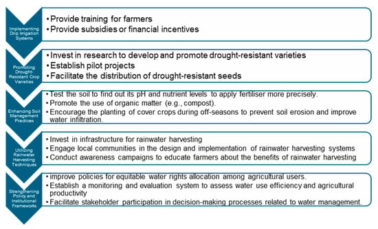
Figure 14.
Possible pillars for an action plan to promote sustainable farming.
Investing in the rehabilitation and maintenance of existing hydraulic infrastructure will help reduce water wastage and loss in distribution networks, ensuring more effective utilization of available resources. Additionally, investing in wastewater treatment plants can create a valuable source of recycled water for non-potable uses like industry and agriculture, enhancing overall water allocation efficiency. Adopting an integrated approach to water resource management that considers the needs of domestic, industrial, and agricultural sectors is essential, as coordination among these sectors can lead to more efficient water use. Establishing a comprehensive and accessible data-sharing platform to facilitate the exchange of relevant water resource data is also important. Given the significant impact of population growth on water demand, implementing comprehensive planning and management strategies, including policies to control growth rates and promote sustainable development, is necessary. To reduce domestic water usage, promptly repairing faucet and pipeline leaks can prevent significant water loss over time. Collecting rainwater for outdoor irrigation is an effective way to conserve fresh water while providing plants with a chemical-free alternative. Educating household members on simple water-saving habits, such as turning off the tap while brushing their teeth and using appliances efficiently, can lead to long-term water savings and promote sustainable home practices. Finally, public awareness campaigns can further support these efforts by educating individuals and industries about responsible water use and conservation practices.
Author Contributions
Conceptualization, M.E.A.B., C.A., K.A.M., A.B. and N.K.; methodology, M.E.A.B., C.A. and K.A.M.; software, M.E.A.B., C.A. and K.A.M.; validation, M.E.A.B., C.A., K.A.M., A.B. and N.K.; formal analysis, M.E.A.B., C.A., K.A.M. and N.K.; investigation, M.E.A.B. and K.A.M.; resources, C.A., K.A.M. and N.K.; data curation, M.E.A.B., C.A., K.A.M. and N.K.; writing—original draft preparation, M.E.A.B.; writing—review and editing, M.E.A.B., C.A., K.A.M., A.B. and N.K.; visualization, M.E.A.B., C.A., K.A.M., A.B. and N.K.; supervision, K.A.M. and C.A.; project administration, C.A., K.A.M. and N.K. All authors have read and agreed to the published version of the manuscript.
Funding
This research was financially supported by the Algerian Ministry of Higher Education and Scientific Research (MESRS). This work was supported by the University of Tlemcen and the Pan African Union Institute of Water and Energy Sciences, incl. Climate Change (PAUWES). This study was conducted with the Integrated Water Resources Management of Algeria.
Data Availability Statement
Data are contained within the article.
Acknowledgments
This work has been accomplished in the framework of an international research program. The authors gratefully acknowledge the support of the Algerian Ministry of Higher Education and Scientific Research (MESRS), the University of Tlemcen, the Pan African Union Institute of Water and Energy Sciences, incl. Climate Change (PAUWES), and the Integrated Water Resources Management in Algeria.
Conflicts of Interest
The authors declare that they have no known competing financial interests or personal relationships that could have appeared to influence the work reported in this paper.
References
- Okello, C.; Tomasello, B.; Greggio, N.; Nina, W.; Antonellini, M. Impact of Population Growth and Climate Change on the Freshwater Resources of Lamu Island, Kenya. Water 2015, 7, 1264–1290. [Google Scholar] [CrossRef]
- Zekri, S.; Drouiche, N.; Khacheba, R.; Soni, R.; AbuZeid, K.M. Water Policies in MENA Countries; Springer: Cham, Switzerland, 2020. [Google Scholar]
- Bouchentouf, S.; Benabdeli, K. Water resources and food security in Algeria: Diagnosis and new strategy proposition. Afr. J. Agric. Res. 2021, 17, 414–424. [Google Scholar] [CrossRef]
- Masmoudi, R.; Kettab, A.; Brémond, B. Drinking water consumption and loss in Algeria the case of networks with low level counting. J. Urban Environ. Eng. 2016, 10, 162–168. [Google Scholar] [CrossRef]
- Rakotondrabe, A. Study of the Vulnerability Of Water Resources to Climate Change, Modeling by the WEAP Software: Case of the Morondava Watershed (SouthWest of Madagascar); Department of Mines, Polytechnic Superior School of Antananarivo: Antananarivo, Madagascar, 2007. [Google Scholar]
- SEI. WEAP Water Evaluation and Planning System User Guide; Stockholm Environ Institute: Somerville, MA, USA, 2011. [Google Scholar]
- WEAP Tutorial. Water Evaluation And Planning System Tutorial. A Collection of Stand-Alone Modules to Aid in Learning the WEAP Software; Stockholm Environment Institute: Somerville, MA, USA, 2005. [Google Scholar]
- Mansouri, S.; Lahbassi, O.; Mohamed, R. Inter-region planning and analysis of water resources by using WEAP model Seybouse (Annaba) and Coastal East of Constantine (El-Taref). J. Water Land Dev. 2017, 33, 115. [Google Scholar] [CrossRef]
- Sieber, J.; Purkey, D. Water Evaluation and Planning System (Weap), User Guide; Stockholm Environment Institute, U.S. Center 11 Curtis Avenue: Somerville, MA, USA, 2011. [Google Scholar]
- Benbouziane, Z. Management of the Water Resource of the Mao Project. Master’s Thesis, University of Science and Technology of Oran, Department of Hydraulics, Bir El Djir, Algeria, 2016. [Google Scholar]
- Berredjem, A.-F.; Hani, A. Modelling current and future supply and water demand in the northern region of the Seybouse Valley. J. Water Land Dev. 2017, 33, 31–38. [Google Scholar] [CrossRef][Green Version]
- Bessedik, M.; Abdelbaki, C.; Tiar, S.M.; Badraoui, A.; Megnounif, A.; Goosen, M.; Mourad, K.A.; Baig, M.B.; Alataway, A. Strategic Decision-Making in Sustainable Water Management Using Demand Analysis and the Water Evaluation and Planning Model. Sustainability 2023, 15, 16083. [Google Scholar] [CrossRef]
- Guettaf, M.; Maoui, A.; Ihdene, Z. Assessment of water quality: A case study of the Seybouse River (North East of Algeria). Appl. Water Sci. 2017, 7, 295–307. [Google Scholar] [CrossRef]
- Mourad, K.A.; Alshihabi, O. Assessment of future Syrian water resources supply and demand by WEAP model. Hydrol. Sci. J. 2016, 61, 393–401. [Google Scholar] [CrossRef]
- Ismail Dhaqane, A.; Murshed, M.F.; Mourad, K.A.; Abd Manan, T.S.B. Assessment of the Streamflow and Evapotranspiration at Wabiga Juba Basin Using a Water Evaluation and Planning (WEAP) Model. Water 2023, 15, 2594. [Google Scholar] [CrossRef]
- Daifallah, T.; Azzedine, H.; Sayad, M.; Salem, B.; Halimi, S. Water resources and their management under impact of climate change and users pressures in Kebir-West River basin (North-Eastern Algeria), using the WEAP model. J. Biodivers. Environ. Sci. (JBES) 2017, 10, 19–26. [Google Scholar]
- AGIRE. Internal Report, Agence Nationale de Gestion Intégrée des Ressources en Eau. 2023. Available online: http://pro.agire.dz/ (accessed on 5 July 2023).
- Mokhtari, E.; Farouk, M.; Abdelkeb, B.; And Engel, B. Flood risk assessment using analytical hierarchy process: A case study from the Cheliff-Ghrib watershed, Algeria. J. Water Clim. Chang. 2023, 14, 694–711. [Google Scholar] [CrossRef]
- Ghrib Report. Assessment of the Pollutant Load in the GHRIB Dam Catchment Area; Technical Report on Ghrib Dam; Wilaya of Ain Defla: Ain Defla, Algeria, 2022.
- Meftah, A. Rain-flow Modelling Using Hec Hms Software Case of Oued Cheliff-Ghrib. Master’s Thesis, M’sila University, Hydraulics Department, M’Sila, Algeria, 2014. [Google Scholar]
- Namous, N. Spatio-Temporal Variability of Precipitation—Case of the Oued Chelif-Ghrib Catchment Area. Master’s Thesis, Université Larbi Ben m’hidi-Oum El Bouaghi, Civil & Hydraulic Engineering Department, Oum El Bouaghi, Algeria, 2012. [Google Scholar]
- Alhaji. Algeria Drinking Water Programme in Medea City. 2021. Available online: https://constructionreviewonline.com/news/algeria-launches-drinking-water-programme-in-medea-city/ (accessed on 5 July 2023).
- ASISD. Agricultural Statistics and Information Systems Department. Agricultural Statistics Report of Medea. Areas and Productions; ASISD: Arlington, TX, USA, 2021. [Google Scholar]
- Medea. Monography of the Wilaya of Medea. 2020. Available online: https://www.aniref.dz/DocumentsPDF/monographies/MONOGRAPHIE%20WILAYA%20MEDEA.pdf (accessed on 29 March 2024).
- Benhocine, A. Current Status of Dams in the Cheliff-Zahrez Watershed Cheliff-Zahrez. Master’s Thesis, Faculty of Technology, Saad Dahlab University of Blida, Ouled Yaïch, Algeria, 2020. [Google Scholar]
- Bensmaine, L. Climate Change in Algeria and its Impacts. 2022. Available online: https://assafirarabi.com/en/48562/2022/11/05/climate-change-in-algeria-and-its-impacts/ (accessed on 17 May 2023).
- Tadjenni, W. Diagnosis of the Purification Efficiency of the Medea Wastewater Treatment Plant. Master’s Thesis, Yahia Fares University, Medea, Algeria, 2022. [Google Scholar]
- Hamaidi-Chergui, F.; Zoubiri, A.F.; Debib, A.; Hamaidi, M.S.; Kais, H. Occurrence and Removal of Pathogens and a Preliminary Study of Microfauna in the Medea Sewage Treatment Plant; Biotechnology, Environment and Health Laboratory, Department of Biology and Cell Physiology, Blida 1 University: Blida, Algeria, 2016. [Google Scholar]
- Dimova, G.; Tzanov, E.; Ninov, P.; Ribarova, I.; Kossida, M. Complementary use of the WEAP model to underpin the development of SEEAW physical water use and supply tables. Procedia Eng. 2014, 70, 563–572. [Google Scholar] [CrossRef]
- CACI Training Department of the Algerian Chamber of Commerce and Industry. 2022. Available online: https://elmouchir.caci.dz/ar/entreprise/14585/belaid-fils (accessed on 2 July 2023).
- Messatpha, K. Study of the Vulnerability of Water Resources to Climate Change Case of the Tafna Basin. Master’s Thesis, University of Science and Technology of Oran, Department of Hydraulics, Bir El Djir, Algeria, 2015. [Google Scholar]
- Mishra, B.K.; Regmi, R.K.; Masago, Y.; Fukushi, K.; Kumar, P.; Saraswat, C. Assessment of Bagmati river pollution in Kathmandu Valley: Scenario-based modeling and analysis for sustainable urban development. Sustain. Water Qual. Ecol. 2017, 9, 67–77. [Google Scholar] [CrossRef]
- FAO. Coping with Water Scarcity—An Action Framework for Agriculture and Food Security; Food and Agricultural Organization of The United Nations: Rome, Italy, 2012. [Google Scholar]
- Adgolign, T.B.; Rao, G.V.R.S.; Abbulu, Y. WEAP modeling of surface water resources allocation in Didessa Sub-Basin, West Ethiopia. Sustain Water Resour. Manag. 2016, 2, 55–70. [Google Scholar] [CrossRef]
- Ayt Ougougdal, H.; Yacoubi Khebiza, M.; Messouli, M.; Lachir, A. Assessment of future water demand and supply under IPCC climate change and socio-economic scenarios, using a combination of models in Ourika Watershed, High Atlas, Morocco. Water 2020, 12, 1751. [Google Scholar] [CrossRef]
- Khalil, A.; Rittima, A.; Phankamolsil, Y. The projected changes in water status of the Mae Klong Basin, Thailand, using WEAP model. Paddy Water Environ. 2018, 16, 439–455. [Google Scholar] [CrossRef]
Disclaimer/Publisher’s Note: The statements, opinions and data contained in all publications are solely those of the individual author(s) and contributor(s) and not of MDPI and/or the editor(s). MDPI and/or the editor(s) disclaim responsibility for any injury to people or property resulting from any ideas, methods, instructions or products referred to in the content. |
© 2024 by the authors. Licensee MDPI, Basel, Switzerland. This article is an open access article distributed under the terms and conditions of the Creative Commons Attribution (CC BY) license (https://creativecommons.org/licenses/by/4.0/).