1. Introduction
River morphological dynamics are natural events [
1,
2] resulting from processes involving water flow, erosion, solid transport, and sedimentation. Natural phenomena such as channel migration, floodplain erosion, and accretion [
3,
4] are the results of fluvial dynamics [
5,
6,
7,
8,
9]. A GIS can be successfully applied to analyze earth observation data and to develop forecast models, for example, to model flash floods [
10]. River bank retreat and channel course changes are more related to climate change, the amount and type of sediment discharged, and changes in the hydrological regime [
11,
12]. The analysis of the spatiotemporal modifications of river dynamics can be performed using GIS techniques [
13]. However, basin-wide anthropogenic development activities such as the construction of hydroelectric dams, the construction of irrigation infrastructure along river banks, and changes in land use accelerate the natural geomorphological behavior of the river [
14,
15,
16,
17,
18,
19,
20]. These anthropogenic actions increasingly cause phenomena such as floods and droughts [
21] and the severe degradation of river systems via disruption of the sediment supply. The study by Dawson et al. [
22] presented a novel approach for evaluating changes in river morphology using a geomorphic form variation (GFV) approach. The researchers employed GIS tools to analyze and quantify riverbed surface-form variations. A detailed assessment of the river morphology was achieved in the study by integrating selected component surface-form metrics into ArcGIS. The River Builder software version 1.2.0 was consulted to support GFV testing, helping to refine the geomorphic metrics used.
Geographic information systems (GISs) have become indispensable tools in the study and management of river dynamics. The integration of GISs with hydrological and hydraulic modeling offers comprehensive insights into river behaviors, flood risk assessment, sediment transport, and ecological impacts. GISs provide a robust platform for storing, analyzing, and visualizing spatial data related to river systems. The ability to handle large datasets and perform spatial analyses makes GISs ideal tools for fluvial geomorphological studies. GISs aid with mapping flood extents, analyzing flood frequency, and assessing potential impacts on infrastructure and populations. Remote sensing data combined with a GIS enhance the accuracy of floodplain mapping and hazard assessment [
23,
24,
25,
26].
The use of remote sensing data and geographic information system (GIS) tools is becoming mainstream for evaluating river channel evolution thanks to the increased availability of high-resolution satellite images over space and time [
27]. In recent years, geospatial tools and techniques, specifically remote sensing (RS) and geographical information systems (GISs), have revolutionized the field of geomorphology. These tools have proven to be invaluable for detecting changes in rivers and their floodplain dynamics on a strategic scale. Their ability to cover spatiotemporal aspects using synoptic data and their powerful analytical capabilities for integrating various datasets have made them essential in modern geomorphological studies [
28,
29,
30,
31]. Unlike traditional geomorphological investigation methods, which often require labor-intensive data collection through extensive field surveys and subsequent data processing, GISs and RS provide a more efficient and effective means of extracting, processing, storing, visualizing, and analyzing spatial data related to river channels. These technologies enable researchers to obtain scientific answers to questions about historical and current morphological changes in river channels—answers that would be difficult to acquire through conventional methods due to limitations related to time and the extent of ground coverage. The integration of RS and GISs allows for a comprehensive analysis of river dynamics by leveraging accessible, inexpensive, and often open-source remote sensing data. This capability facilitates the rapid detection of morphological changes and an understanding of how these changes affect river channels over time. The synoptic nature of remote sensing data provides broad spatial coverage and the temporal resolution necessary for monitoring changes at various scales. However, the exclusive use of remotely sensed data without complementary field-based knowledge can introduce potential errors. Also, in the field survey area, GISs embedded in mobile devices can provide important support for the recognition and mapping of river forms [
32]. This integrated approach provides a more comprehensive understanding of current river conditions and aids with predicting future trajectories [
33,
34,
35]. As technological advancements continue to enhance the capabilities of RS and GISs, their role in geomorphological research will undoubtedly become even more significant, offering new opportunities for monitoring and managing riverine environments effectively.
RiverMetrics is a QGIS [
36] plugin that consists of a set of different tools that allow the extraction of a number of river metrics that are useful for determining the evolutionary state of a watercourse. The first set of tools extracts sinuosity data from the geometric shape of the channel axis, allowing for a detailed analysis; the second set analyzes the state of the weaving of the riverbed; and the third focuses on the trend of the elevation profile. The advantage of using the RiverMetrics plugin is the ease of input data entry allowed by the QGIS software version 3.30 and the specific graphs that are produced, with which the user can interact directly.
In this paper, we present the main features and development choices of the RiverMetrics plugin in
Section 2.
Section 3.1 focuses on illustrating a representative case study, and
Section 4 reports the final results.
2. RiverMetrics Architecture
RiverMetrics was developed in the Python 3 environment (
www.python.org) and is currently compatible with QGIS-3.22 [
36] and later versions. QGIS is a free and open-source desktop GIS that has rapidly gained popularity recently due to its ease of use and due to the possibility of extending its potential by creating plugins in Python. The RiverMetrics plugin is available through the website
https://github.com/pierluigiderosa/RiverMetrics (accessed on 31 August 2024) for the dockable interface and
https://github.com/Freddi-kru/RiverMetrics-plugin---processing for the processing interface (accessed on 31 August 2024). The plugin is divided into two main parts: the first part is a dock that is integrated into the main QGIS interface, while the second part consists of a set of tools that are integrated into QGIS processing.
2.1. RiverMetrics in Dockable Interface
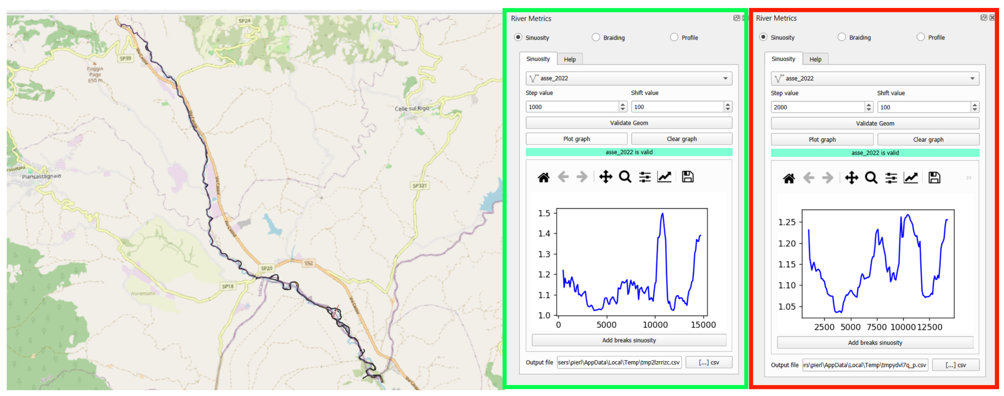
The RiverMetrics module built as a dock interface of QGIS has the function of exploring three basic metrics of a riverbed: sinuosity, braiding, and profile variation. To determine the sinuosity, the tool simply requires as input the riverbed axis and two values: the step and the shift. The step value represents the length of the river arc that is used for sinuosity determination expressed as the ratio of the arc length (step) to the 2D distance between the beginning and the end of the reach. The shift value, on the other hand, represents the distance the arch is shifted by, by obtaining a new stream arc.
Figure 1 compares a sinuosity graph obtained with a value of 1000 m in the left part and 2000 m in the right part. Starting from the same reach of the river with a length of 12 km, the graph presents only one part with high sinuosity values, using a step value of 1000 m; in the case of a step value equal to 2000 m, there exists a second part with high sinuosity values.
The braiding index (BI) uses as input data the linear vector representing the river axis and the polygonal vector representing the full riverbed (i.e., the polygon of the riverbed without the bars). The tool is used to create the cross-sections at each step value that are grouped according to the stationing value along the centerline. The BI values are shown in the graph below, with which an expert user can manually divide the stream into reaches.
The longitudinal profile constitutes the third and final part of the RiverMetrics plugin in dockable mode (
Figure 2). The user must select the river axis and the DTM. RiverMetrics determines and plots all cross-sections and for each of them samples the raster DTM by identifying the point with the minimum elevation (thalweg). All minimum points are plotted on the map, and the graph is constructed from upstream to downstream with the elevation trend. Similarly to the other tools (sinuosity and braiding), the user can interactively divide the riverbed track into sections by adding breaks on the graph, creating a new linear vector layer that is subdivided according to the chosen breaks.
All the information provided is extremely useful for expert monitoring of rivers and controlling the river status and evolution trend.
2.2. RiverMetrics in Processing Interface
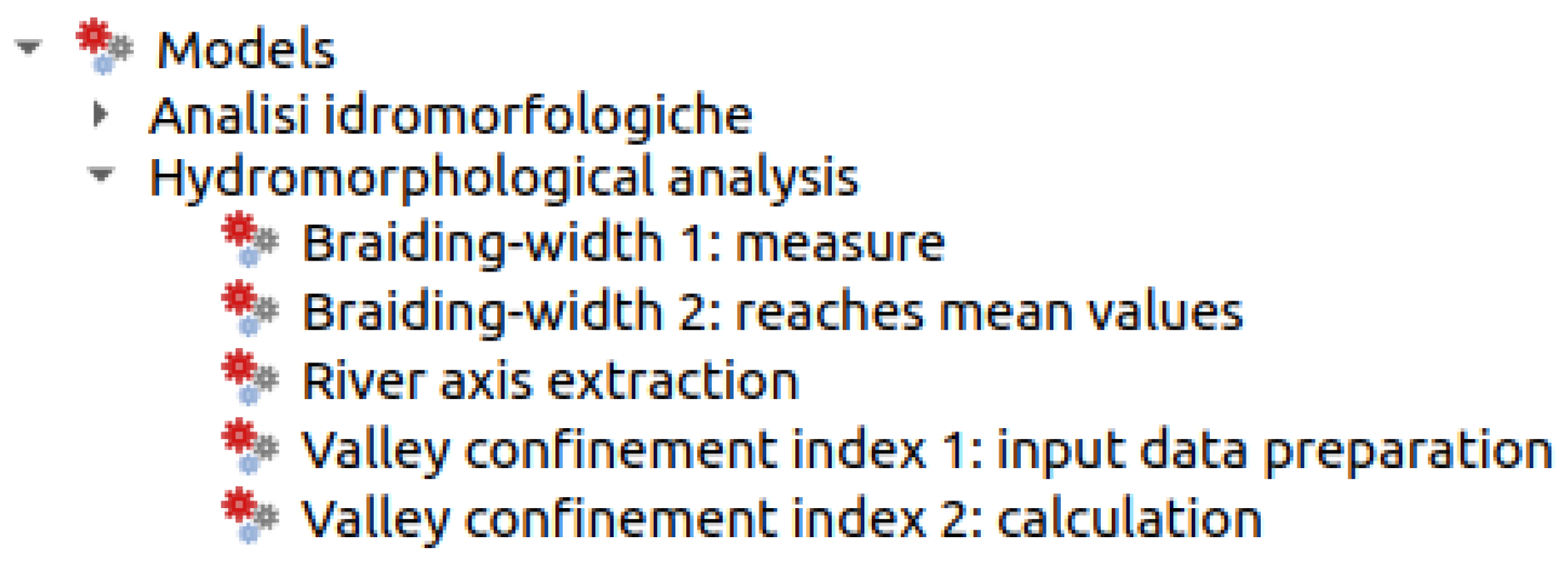
The RiverMetrics plugin has a number of tools that are integrated into the QGIS processing panel. The tools implemented have been placed in a group called hydromorphological analysis and perform various river metric operations. They are listed below:
Braiding-width 1: measure;
Braiding-width 2: reaches’ mean values;
River axis extraction;
Valley confinement index.
Figure 3 shows how the four tools are accessible from the QGIS interface in the processing panel.
The valley confinement index (VCI) module is divided into two parts: the first part prepares the input data from the bankfull-stage riverbed layer, the plain vector, and the polygon vector of the reaches.
The second module uses the linear layer banks and the polygonal layer of the buffer slopes. It divides the slopes and banks according to reaches and calculates the total length of the banks and the length of the banks in touch with the slope. Finally, it determines the degree index of confinement given as the percentage of banks in contact with the slope.
The second module, river axis extraction, uses the bankfull-stage riverbed as input and performs a skeletonization operation by transforming the polygon into a line.
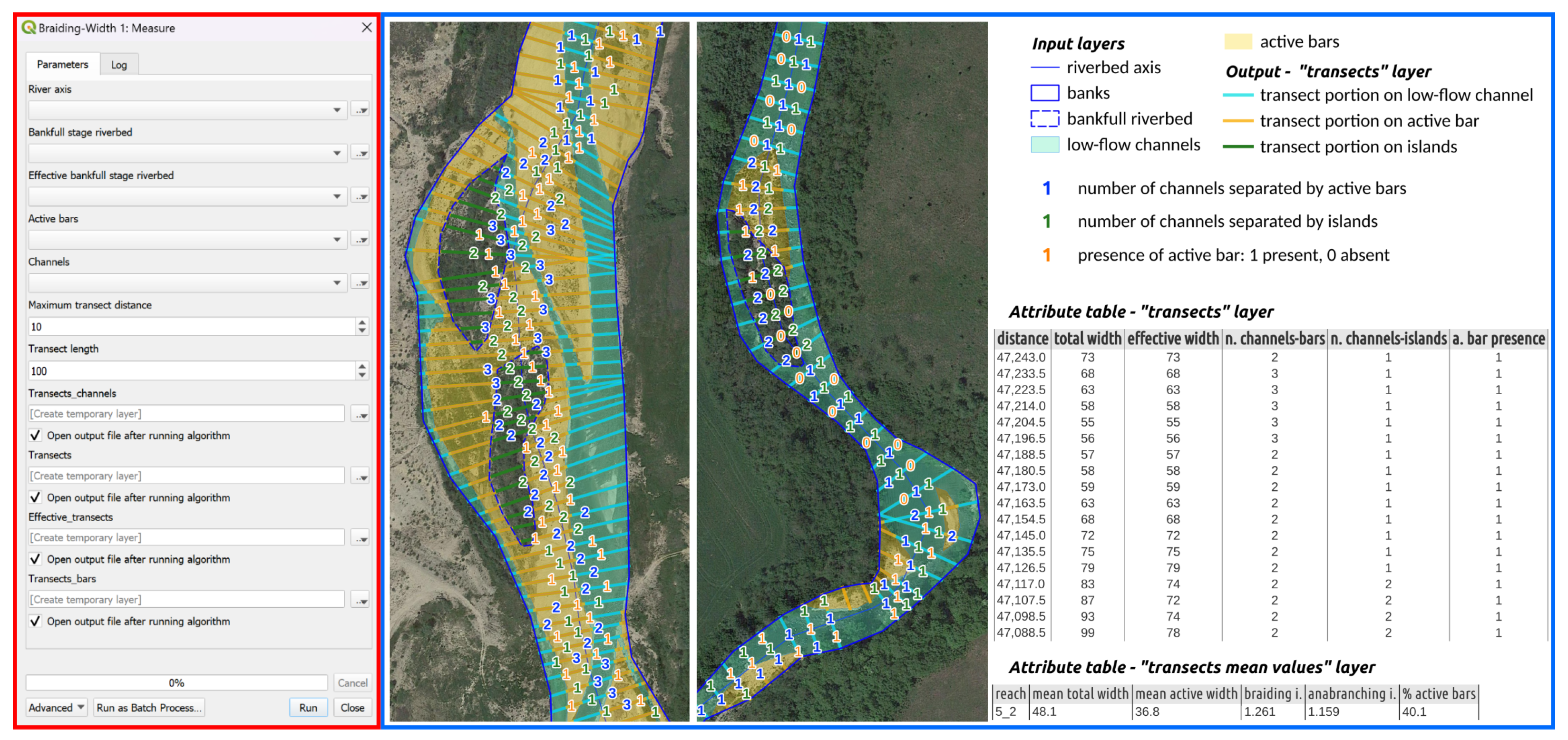
The braiding index module is divided into two parts: the first part performs the calculations, and the second averages and then determines the BIs, the anabranching index (AI), and the percentage of bare bars in the reach.
The output produced is a polygon file of the reaches that has all the average values of the above indexes in its attribute table (see
Figure 4).
3. Materials and Methods
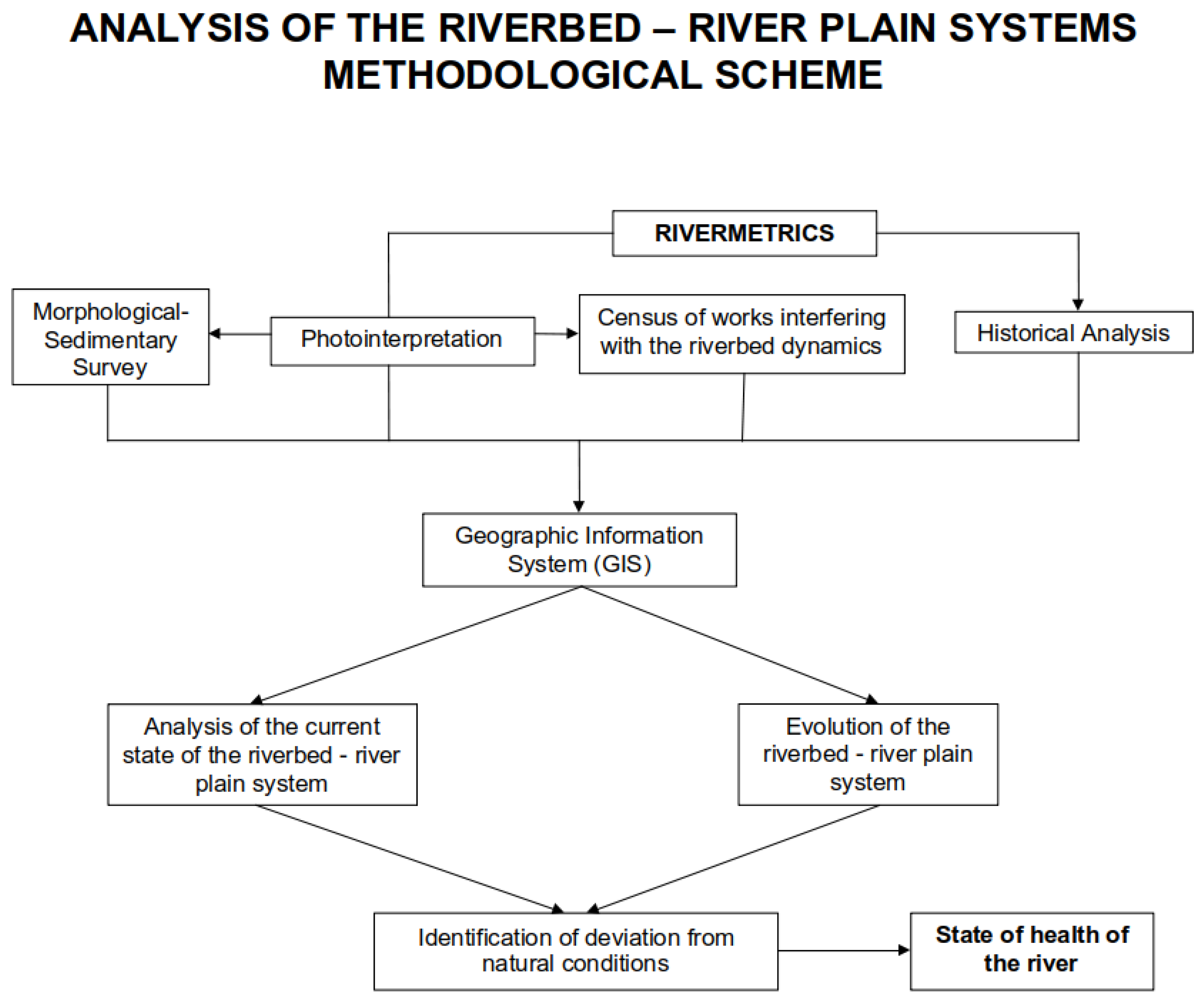
The methodology used for the analysis of the riverbed–floodplain system is briefly described in the flow chart in
Figure 5. Photointerpretation of aerial and satellite images represents the first phase of investigation. It has a threefold purpose:
It is preparatory to the field survey of the morphological–sedimentary and anthropogenic features of the system. From the most recent satellite photos (often, in the absence of recent images, those taken from Google Earth are used), it is possible, first of all, to identify the access points to the river so as to increase the accuracy and speed of the field survey activity.
The morphological–sedimentary characteristics of the riverbed and floodplain (the lean channel, banks, sedimentary bodies, and their vegetative state, bottom forms, and confluences and their relationships with the main riverbed where possible—especially in terms of sedimentary supply) and anthropogenic works (transverse and longitudinal) that interfere with the dynamics of the riverbed are surveyed. All these characteristics need subsequent field monitoring to confirm and implement the information deduced from photointerpretation.
Finally, the analysis of aerial photos prior to the current state, produced by successive aerophotogrammetric flights over time, makes it possible to perform a historical analysis and to identify the evolutionary trend of the river. This is where the application of RiverMetrics comes in, which makes it possible to compare and verify the variation over time in the morphological parameters of the riverbed described in the previous section (sinuosity index, braiding index, profile variations).
On the other hand, the historical analysis is not limited to the analysis of aerial photos, which are dated to the mid-20th century at the earliest, but rather can also be applied to the examination of earlier historical maps. In Italy, for example, there are historical cadastres, at a large scale and dated mostly from the late 18th century to the first half of the 19th century, which represent the state of the rivers at that time with a high level of detail. Some cadastres compiled at that time are used for this purpose:
The Napoleonic Cadastre, covering much of northern Italy;
The Gregorian Cadastre, covering the former Papal States (Central Italy);
The Lorenese Cadastre, for the Tuscan area;
The Bourbon Cadastre, in Southern Italy.
The abundance of details with which these cadastres (represented by maps at the approximate scale of 1:2000) were drawn up makes it possible to identify the state of the rivers under mostly “natural” conditions before the major transformations due to the interventions carried out in the following centuries up to the present day (rectifications, canalizations, changes in riverbed width, etc.), which disrupted their dynamics. Particular maps and studies have also been found in historical archives (point surveys, referring to specific stretches of riverbeds) that are often the result of legal disputes that arose to define property boundaries: in fact, rivers have always represented natural boundaries that were often (and still are) used as territorial boundaries, even of private property, and these disputes arose precisely from the mobility of the riverbed.
All information and data collected (from photointerpretation, historical map documents, and field surveys) are entered into a geographic database (GIS), through which the current state of the riverbed can be compared with that deduced from the historical analysis. This aspect is of particular importance, as it makes it possible to precisely distinguish the deviation of the current conditions of the river from the “natural” ones from the historical analysis and therefore precisely verify the “state of health” of the river from a geomorphological point of view.
3.1. Application of RiverMetrics to the River Paglia
The River Paglia, one of the main right tributaries of the River Tiber in Central Italy, was studied with automatic measuring instruments.
The river is approximately 49 km in length, and its source is at Mount Amiata (1738 m a.s.l.). The basin covers an area of 1320
in the Tuscany, Umbria, and Latium regions. The outlet is located at the confluence with the River Tiber, in the vicinity of the town of Orvieto.
Table 1 provides a summary of the geomorphological characteristics of the watershed, which extends across Tuscany, Umbria, and Latium.
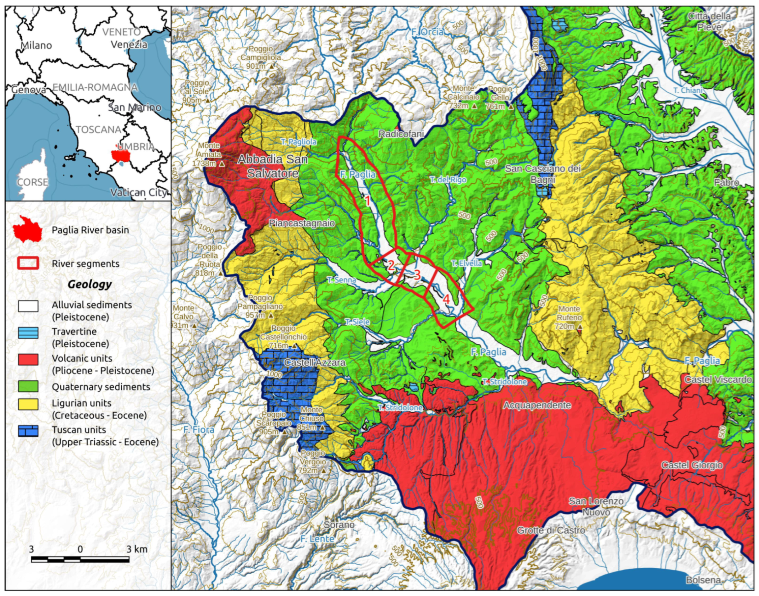
Figure 6 shows the study area and a geological sketch of the river basin.
3.2. The River Paglia—Upper Valley
The study area is located in Tuscany and covers the first 15 km of the river, between the confluence with the Pagliola Creek and those with the River Siele and River Elvella.
After an initial NW–SE oriented reach, near the village of Acquapendente, the river turns eastward, creating a narrow gorge. Then, downstream from Castel Viscardo, the River Paglia returns to a NW–SE direction until it joins the River Tiber.
The basin is characterized by a large lithological variability. It contains both sedimentary rocks belonging to different stratigraphic–structural units and magmatic rocks belonging to different volcanic districts. On the whole, poorly permeable lithotypes (silt, clay, and marl) predominate [
32].
The following formations are present in the part of the catchment that includes the first stretch of the river (
Figure 6):
Tuscan units (Upper Triassic to Eocene) consisting mainly of evaporites, calcarenites, limestones, and marls. They outcrop in the area of M. Cetona, near the village of S. Casciano dei Bagni, and to the west near Castell’Azzara;
Ligurian units (Cretaceous to Eocene) made up of a nappe of an allochthonous flysh-type sequence (limestones, marly limestones, marls, clays, sandstones, and calcarenites);
Quaternary sediments filling the extensional tectonic basins that dissect the compressive fold-and-thrust structures, overlapping with the lithotypes of the Tuscan and Ligurian sequences. They are composed of clays, sands, and conglomerates (marine and deltaic facies);
Volcanic units formed as a result of intense extensional tectonic volcanic activity, which produced several emission centers between the Pliocene (Vulsini Complex) and Quaternary (Monte Amiata) periods. The rocks of the Vulsini Complex are located in the meridional part of the watershed, covering the flysch and marine sediments [
37,
38].
The bedrock of the catchment has a profound influence on the hydrological regime and sediment transport of the river [
32].
The prevalence of poorly permeable lithotypes is responsible for the typical torrential hydrological regime observed in the river.
The sediment supply comprises both coarse material derived from lithoid formations and conglomerates (the top of the marine Pliocene series), and both are composed of fine materials. The sediments are highly heterogeneous, yet the river dynamics is primarily influenced by medium- to large-sized elements, which, under natural conditions, facilitate the formation of a braided morphological pattern [
39,
40].
3.3. Definition of the Current Morphological–Sedimentary Conditions of the Fluvial System
In accordance with the methodology proposed by Cencetti et al. [
32], the present morphological and sedimentary conditions of the river system were delineated first through the interpretation of the most recent aerial photographs and a comprehensive survey of the riverbed.
Photointerpretation was conducted using aerial photographs from historic flights (from 1954 and later) up to the most recent images available from Google Earth, which were available up to April 2022 for the river segment under analysis.
The methodology entailed the vectorization of the principal morphological characteristics of the riverbed and floodplain, which yielded two polygonal data layers, one for the riverbed and one for the floodplain.
The riverbed dataset comprised low-flow channels and sedimentary bodies, which were distinguished according to their vegetation conditions and degree of activity (unvegetated/active, vegetated/active, and arboreal/inactive).
Subsequently, the river morphology data layer was subjected to further analysis with the objective of extracting additional morphological elements of the river. These included the bankfull-stage riverbed, which was obtained using a classical GIS dissolution tool, and the riverbed axis, which was extracted using the RiverMetrics plugin’s “river axis extraction tool”, as previously described in
Section 2.2.
The floodplain dataset was composed of the following elements: the slope/floodplain boundary, landslides, terraces, and alluvial fans. Furthermore, the delineation of fluvial terraces was refined through the utilization of a high-resolution digital terrain model (LiDAR), which permitted the assessment of the confinement grade exerted by terraces on the river. This is of great importance in ascertaining whether a terrace must be incorporated into the slopes or is to be considered part of the floodplain.
The vector data, obtained through photointerpretation and subsequent elaborations, were subjected to analysis using the RiverMetrics tools with the aim of measuring the specific morphological parameters and indexes. These included the following parameters: the valley confinement index, slope, sinuosity, total width, effective width, braiding index, and anabranching index as well as the percentage frequency of active bars.
The resulting data enabled the geomorphological type to be identified in accordance with the definitions proposed by Montgomery and Buffington [
40]. Furthermore, the analysis of the variations in the aforementioned parameters along the riverbed axis permitted the studied section of the river to be divided into four reaches, which may be considered homogeneous with regard to their morphological characteristics (
Figure 6).
Table 2 displays the mean values of the main morphological parameters for each river reach as well as the valley confinement conditions and morphological classification of the riverbed.
The subsequent phase of the workflow comprised a field survey of the morphological and sedimentary characteristics of the riverbed–floodplain system and human-made structures. The objective of the survey was to obtain geomorphological information about the riverbed and the stream corridor that could not be determined via photointerpretation. Second, the survey allowed us to verify the information obtained from the photointerpretation analysis. The following geomorphological aspects were investigated:
The bank conditions were evaluated in terms of height, erosion/progradation processes, bank failures, and riparian vegetation characteristics (density, lateral extent, and exposed roots);
The riverbed conditions were investigated in terms of sediment granulometric size (visual evaluation), armoring and clogging processes, and degradation/aggradation processes (bedrock outcrops);
The hydraulic works, both longitudinal and transversal, were examined in terms of frequency and state of preservation.
The field survey revealed that processes of lateral erosion and bottom degradation were the most prevalent, occurring with great intensity and pervasiveness. Furthermore, the processes of bank erosion were frequently observed in straight sections, behind lateral bars, or on the inner bank of meanders. These observations indicated a state of disequilibrium in the river system, which is typically associated with a deficit of solid transport.
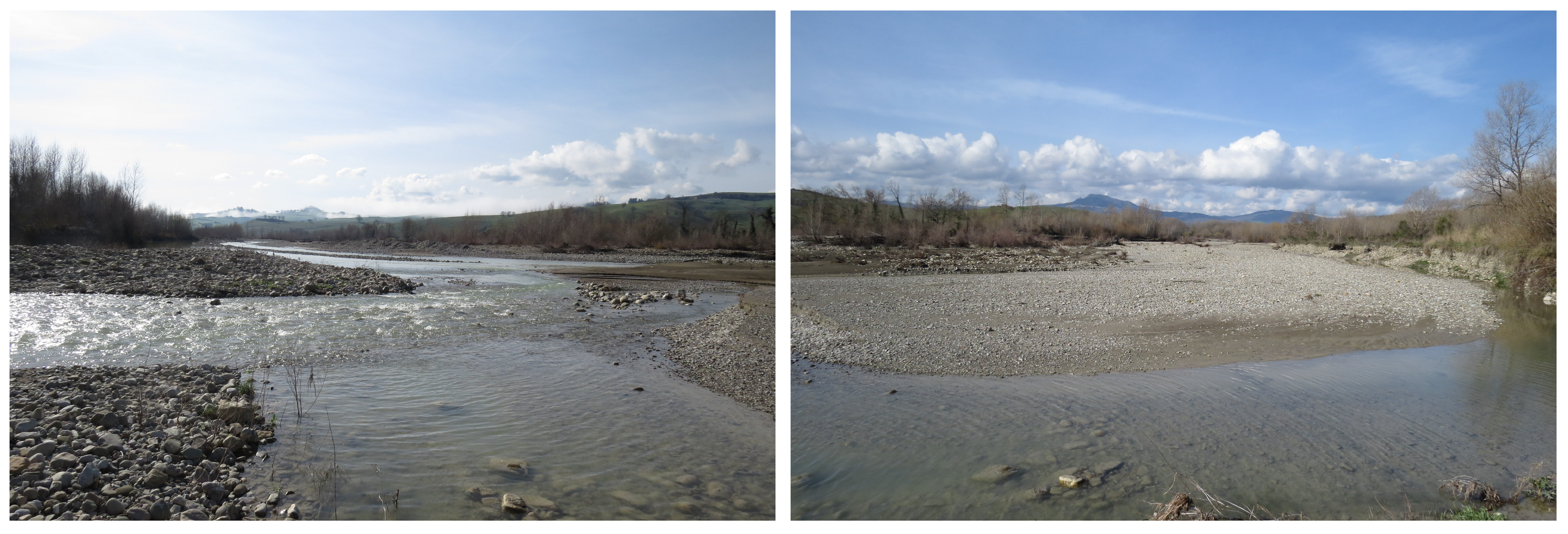
In more detail, the aforementioned processes were particularly evident in the first two reaches, where the Pliocene clay bedrock was extensively exposed (
Figure 7) and the hydraulic structures were often damaged.
Although the morphological changes in the riverbed were more pronounced in the last two reaches, as discussed in more detail in
Section 4, the erosion processes were actually less evident in these segments (
Figure 8). This could be due to the reduction in slope and also to the lateral sediment supply from the Senna and Rigo Creeks, which join the river at the beginning of the second sector.
3.4. Morphological Evolution between 1883 and 2022
A further essential component of the methodology is the examination of historical cartographic documentation. This involves the photointerpretation of aerial images from different time periods and the analysis of historical maps, which allows for the identification of planimetric and, occasionally, altimetric changes in the fluvial system up to the present state.
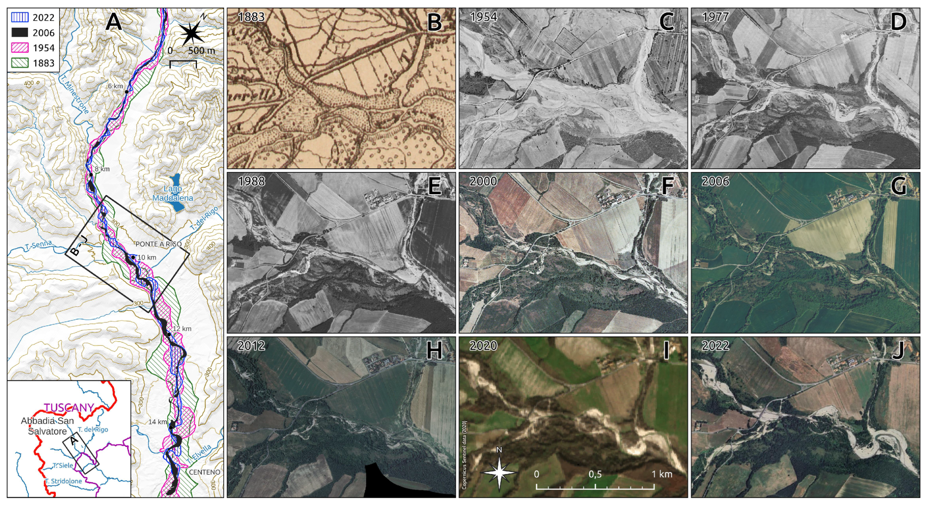
A number of historical cartographic sources were employed in order to investigate the morphological evolution of the riverbed (
Figure 9). The following historical cartographic documents were consulted.
Topographic map of Italy (1850–1900)—source: IGMI (Italian Geographic Military Institute), scale 1:50,000. This comprises the fieldwork cartography used for the production of the first edition of the Topographic Map of Italy. The two maps employed in this study were created in 1883. The authors carried out the process of georeferencing.
Aerial photographs from the “GAI Flight” (1954)—source: IGMI. This was the first aerophotogrammetric survey conducted in Italy by the Italian Aerial Group and commissioned by the IGMI. It represents a pioneering undertaking in Italy. The photograms pertaining to the study area were orthorectified and are accessible via a Tuscany Region web map service.
Orthophotos of the Tuscany Region (1978, 2017), available for download via the web map service;
Orthophotos Catalogue of the Italian National Geoportal (1988, 1996, 2000, 2006, 2012), available for download via the web map service;
Google aerial photographs (2022), available for download via the tile map service.
The aforementioned documents were subjected to a qualitative examination, after which those deemed most relevant for the study of riverbed evolution were selected for further investigation. The IGMI topographic maps (1883) and orthophotos from 1954 and 2006 were selected for the analysis.
As detailed in
Section 3.3, the following operations were replicated for each of the selected documents: photointerpretation and production of the riverbed data layers and calculation of the main specific morphological parameters using RiverMetrics tools.
Subsequently, the comparison of the morphological parameters from the selected periods enabled the identification and quantification of planimetric transformations of the river and its evolution over the period from 1883 to 2022. This was achieved by analyzing both mean values (
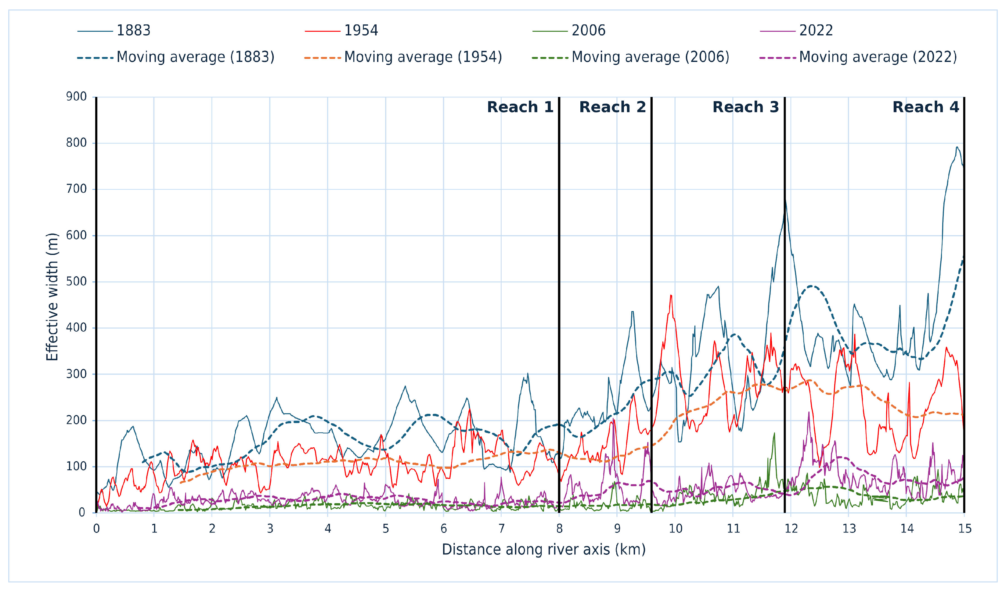
Figure 10) and variation along the riverbed axis of the parameters (
Figure 11), at different points in time.
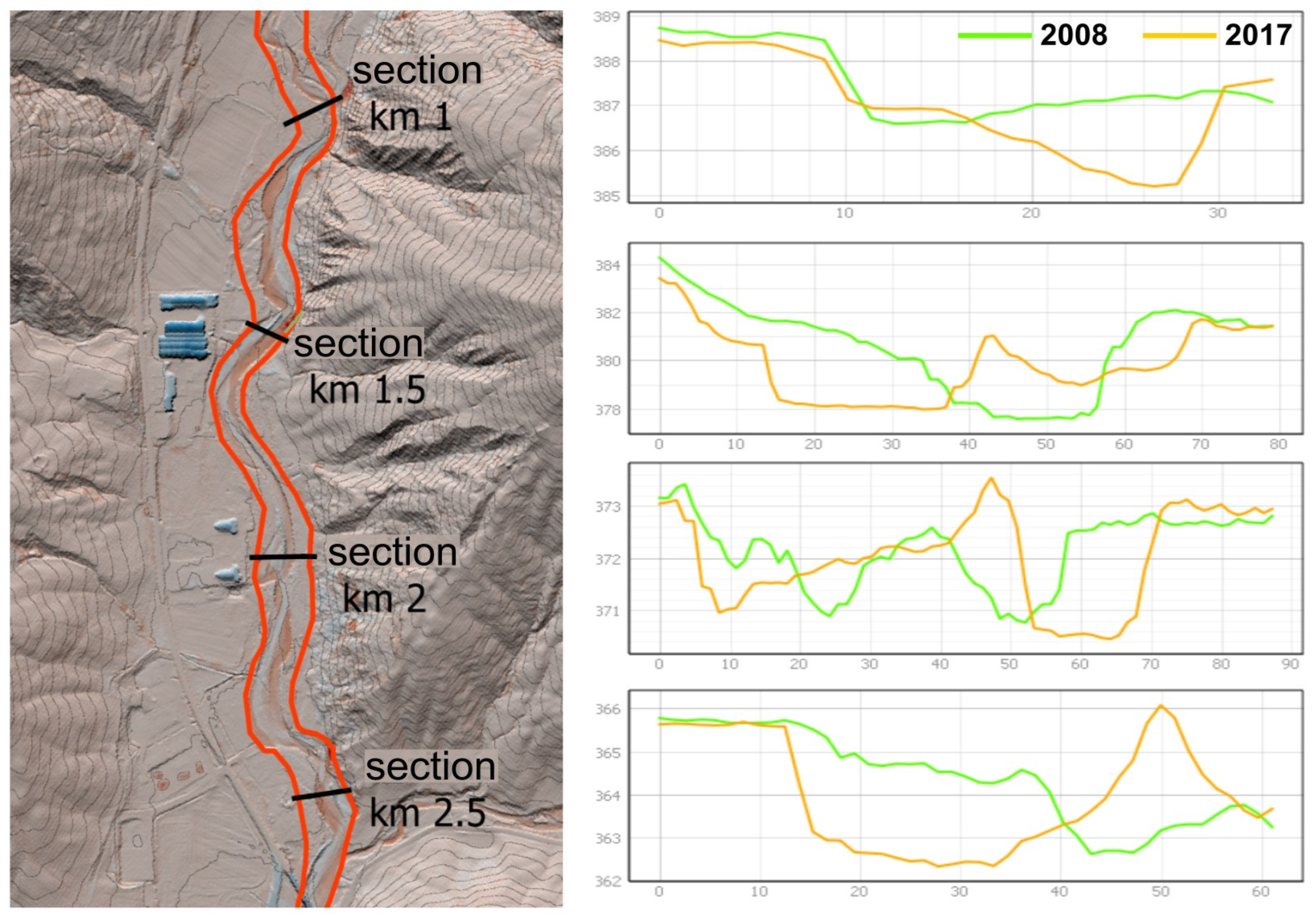
In order to investigate the altimetric modifications of the riverbed, two LiDAR digital terrain models (DTMs) were compared. The DTMs were provided by the Tuscany Region and were acquired in 2008 and 2017, respectively. However, due to the limitations of the available data, it was not possible to superimpose the two datasets over a vast area. The superimposition was only accomplished over a brief segment, approximately 3 km in length, situated in the initial reach.
The analysis was conducted using the “r.mapcalc” tool of the software GRASS GIS version 7.8.0, which enables the execution of map algebra operations between raster data. The “arithmetic difference” between the two digital terrain models (DTMs) enabled the assessment of the altimetric changes in the riverbed over a recent ten-year period (2008–2017). Moreover, it permitted the mapping of the spatial distribution of erosion and sedimentary processes as well as the evaluation of the volumes involved (
Figure 12).
4. Results
The image analysis and geomorphological measurements conducted on the Google aerial photographs (2022) enabled the division of the studied River Paglia segment into four reaches. In the initial two reaches, the stream flowed in a partially confined valley and displayed a sinuous morphology with alternating bars. In the downstream sections, the degree of braiding within the riverbed increased due to the sedimentary inputs of the Siele and Rigo streams, resulting in the development of a “wandering” morphotype (
Table 2).
The field survey revealed that processes of lateral erosion and bottom degradation were occurring with notable intensity and pervasiveness, particularly in the initial two reaches where the marine Pliocene bedrock was extensively exposed (
Figure 7).
The observation of historical cartography revealed that the riverbed had undergone significant alterations over the past 140 years, resulting in a notable morphological reconfiguration. The most important transformation occurred between 1954 and 2006, when the riverbed morphology shifted from a multichannel morphotype, which persisted from 1883 until 1954, to the single-channel, low-sinuosity morphology observed in 2006.
Concurrently, the riverbed underwent notable modifications in width over the study period, though not in a uniform manner. It was possible to identify three distinct phases in the river’s recent history.
The initial phase, which spanned approximately 70 years (1883–1954), saw a slight narrowing of the riverbed from 233 m to 157 m. This represented a decrease of 32% with a rate of 1.1 m per year.
Over the subsequent fifty-two years (1954–2006), the phenomenon increased considerably, reducing the riverbed mean width to 23 m. Overall, in this phase, the riverbed narrowed by approximately 90%, with a rate of 2.6 meters per year (second phase).
Over the past two decades, as evidenced by the most recent aerial photographs from Google Earth (2022), a reversal of the previous trend occurred, with the riverbed partially regaining its original dimensions and morphology (third phase). Indeed, the mean width increased from 23 to 45 m (at a rate of 1.4 meters per year), accompanied by an increase in the BI from 1.16 to 1.27. Consequently, the riverbed returned to a transitional morphology (
Figure 9 and
Figure 10). The widening occurred following major flood events, with the greatest occurring in December 2010 and November 2012.
In addition, the transformation exhibited varying degrees of intensity from upstream to downstream. As highlighted in
Figure 11, both the narrowing prior to 2006 and widening after were more pronounced in sections 3 and 4, where the slope is markedly reduced and the valley becomes wider.
The narrowing process is closely associated with a deepening of the river’s main channel, which has resulted in the gradual abandonment of numerous sedimentary bodies. As illustrated in
Figure 9, the lateral and longitudinal bars, which were active and mobile in 1954, became increasingly vegetated and less mobile by 2006. These phenomena are typical of most Italian and European rivers [
14,
15,
41,
42,
43,
44,
45,
46] and serve as a clear indication of reduced sedimentary transport. A comprehensive understanding of these processes is essential for the effective management and conservation of river systems.
In the case of the River Paglia, the following factors were identified as the primary causes.
A consequence of the progressive abandonment of agricultural practices has been a change in land use. The decline of rural areas and the countryside has resulted in the re-vegetation of slopes, which has led to a reduction in lateral sediment supply.
The reclamation of land for agricultural and construction purposes in riverine areas has the effect of reducing the width of runoff sections, thereby increasing the velocity of the flow and triggering erosion.
The implementation of hydraulic works, including canalization and the rectification of the riverbed, can be expected to have analogous effects to those previously described.
The mining of gravel and sand directly from the riverbed was permitted by law until the 1980s, after which it was conducted as part of maintenance operations. This has resulted in a considerable reduction in the available sediment balance and a deficit in solid transport.
The altimetric variations and the deepening process of the riverbed were detailed between 2008 and 2017 using two LiDAR DTMs provided by the Tuscany Region. The difference between the two DTMs (
Figure 12) allowed us to assess the spatial distribution of the erosion and sedimentary processes and the volumes involved: the sedimentary balance was negative, with a loss of approximately 105,000
of sediment occurring over a relatively short section of the first reach, spanning approximately 3 km. In order to avoid potential errors arising from human intervention and earth-moving activities within the floodplain, the calculations were restricted to the fluvial corridor, which is represented in
Figure 12 by red lines.
5. Conclusions
The use of the RiverMetrics tool for the metric analysis of rivers offers significant advantages in monitoring their evolution and calculating various indexes such as sinuosity, braiding, and altimetric profile trends. The tool’s ability to process and analyze spatial data with precision and efficiency has proved invaluable for hydrological studies and environmental monitoring.
The specific functionalities of the GIS tool allow a detailed and accurate assessment of river dynamics, providing insights that are crucial for environmental management, flood risk assessment, and conservation planning. By automating complex calculations and dividing the riverbed into reaches directly from the graph, the ability to predict and mitigate adverse environmental impacts is enhanced.
In addition, integrating this tool into routine monitoring practices facilitates the collection of standardized and reproducible data, ensuring consistency in analysis and reporting. This leads to more informed decision-making and effective policy implementation in the context of water resource management.
With the application of the RiverMetrics tool to the River Paglia, the historical and morphological analysis carried out highlighted the significant changes that have affected the riverbed over the last 140 years. They have led to its complete morphological reconfiguration, from a multichannel pattern before 1950 to the present single-channel pattern with low sinuosity and alternating bars (wandering, i.e., transitional type). The riverbed has been considerably narrowed, from an average width of about 230 m in 1883 to about 23 m in 2006. This is due to the deepening of the channel and the consequent progressive abandonment of many sedimentary bodies, which are now suspended over the present riverbed. The primary factors responsible for the observed alterations to the River Paglia were identified as follows. The progressive cessation of agricultural practices has changed land use, leading to the re-vegetation of slopes and reducing lateral sediment supply. The reclamation of land for agricultural and construction purposes in riverine areas has resulted in a narrowing of the channel, increasing flow velocity and erosion. Similarly, hydraulic works such as channeling and riverbed regulation had a comparable effect. In addition, historical gravel and sand extraction from the riverbed has significantly reduced the sediment availability, resulting in a sediment transport deficit.
In geomorphological terms, it can be deduced that the river had rather poor “health” in this period as the morphological structure was far from the “natural” conditions as they existed before the 1950s. Subsequently, between 2010 and 2022, the river partially recovered its naturalness, moving to a wandering (transitional) morphology, with an increase in all parameters (excepted for sinuosity) and an increase in active bars (92.6%), thus improving its “geomorphological state of health”. This condition was mainly linked to the two major flood events (2010 and 2012) and to the ban on mining in the riverbed, which had beneficial effects on the present riverbed dynamics.
In conclusion, our specialized GIS tool represents a significant advancement in the field of fluvial geomorphology, providing robust analytical capabilities that support the sustainable management of riverine environments. Its application can lead to more effective monitoring and conservation of river systems, ultimately contributing to the overall health of aquatic ecosystems.
As a future development, the working group is implementing RiverMetrics. The next step involves automating the determination of stream power at every point along the stream. Understanding the stream power distribution provides crucial insights into the river’s capacity to erode, transport, and deposit materials. This information is vital for river management and restoration projects as it helps identify areas prone to erosion or sediment accumulation. As described in [
47], sudden variations in stream power can highlight “sensitive points” related to anomalies in the hydrographic network caused by tectonic or gravitational phenomena (i.e., landslide dams) that alter the relationships between the morphogenetic processes of fluvial dynamics. Additionally, a stream power analysis can aid in predicting flood risks and developing strategies to mitigate their impact, ensuring the safety and sustainability of the surrounding environments and communities.
