Impacts of River Network Connectivity on Flood Signatures and Severity Regulated by Flood Control Projects
Abstract
1. Introduction
2. Materials and Methods
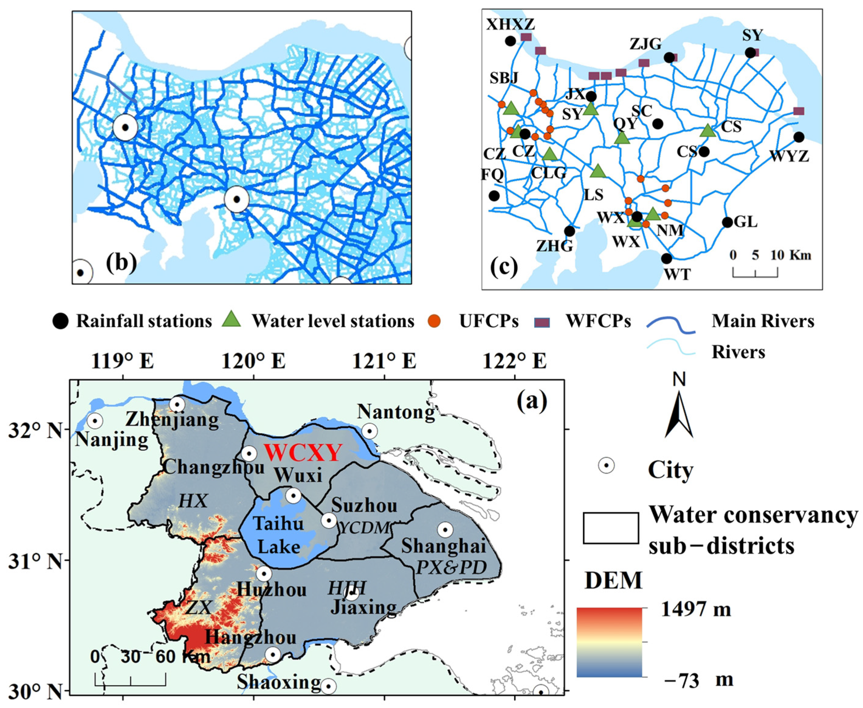
2.1. Study Area
2.2. Methods
2.2.1. Modeling Scenarios of River Network Connectivity Regulated by Engineering
2.2.2. Flood Signatures
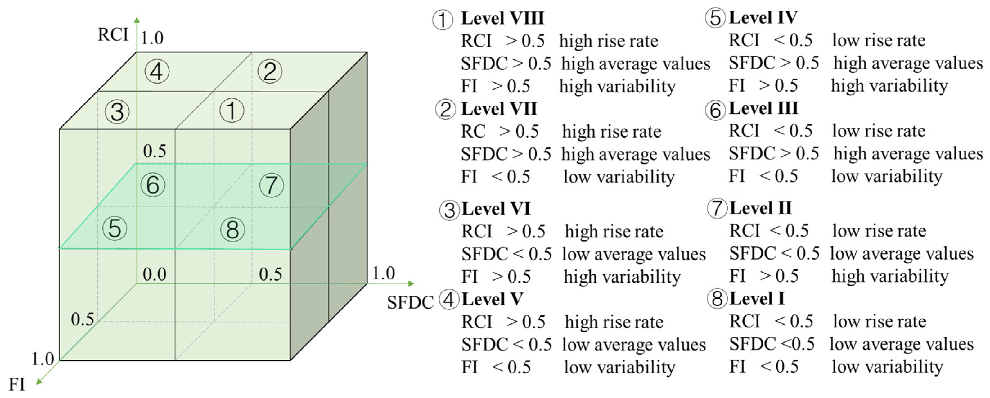
2.2.3. Severity Assessment of Flood Intensity
2.3. Data Description
3. Results
3.1. Model Design
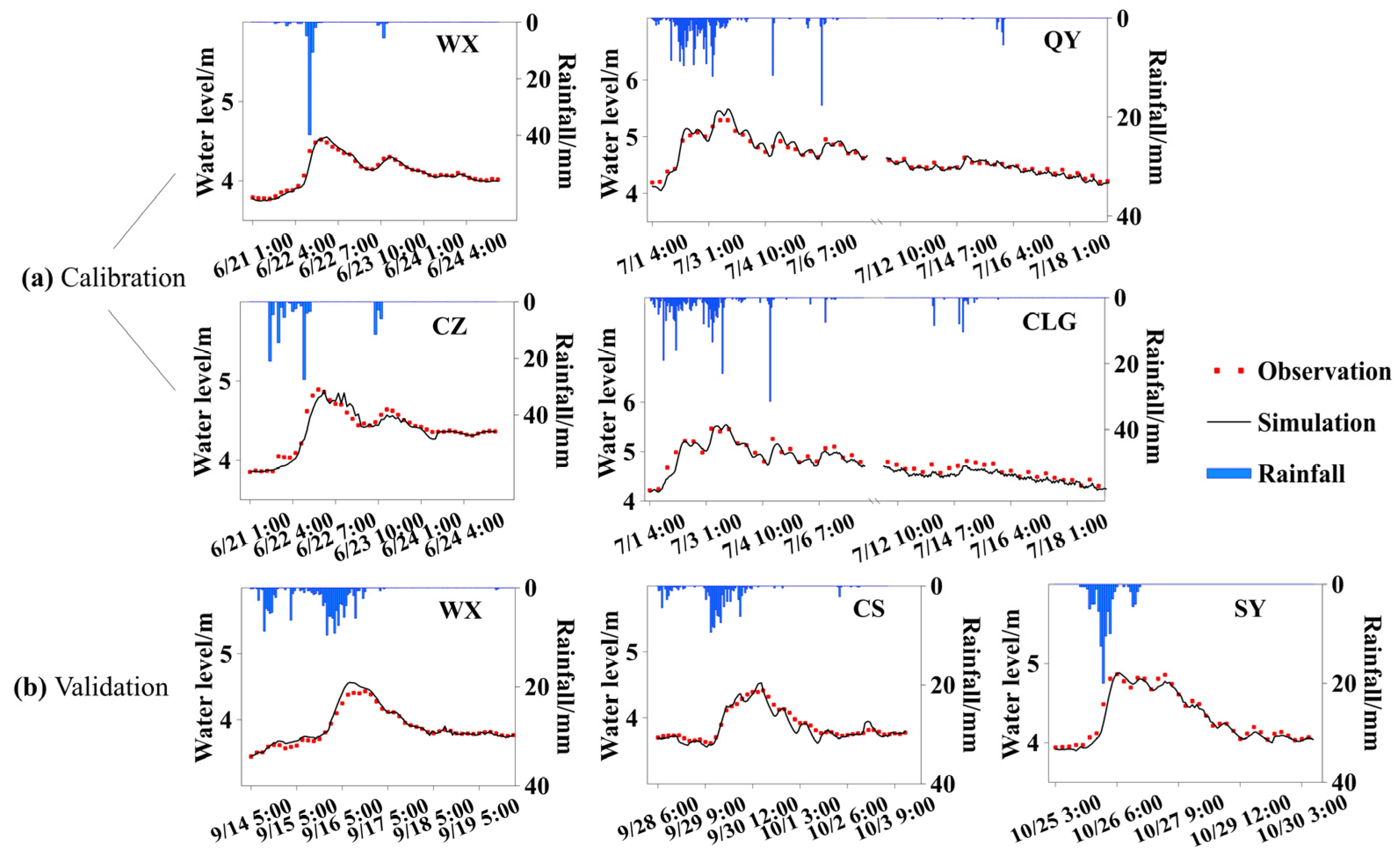
3.1.1. Calibration and Validation
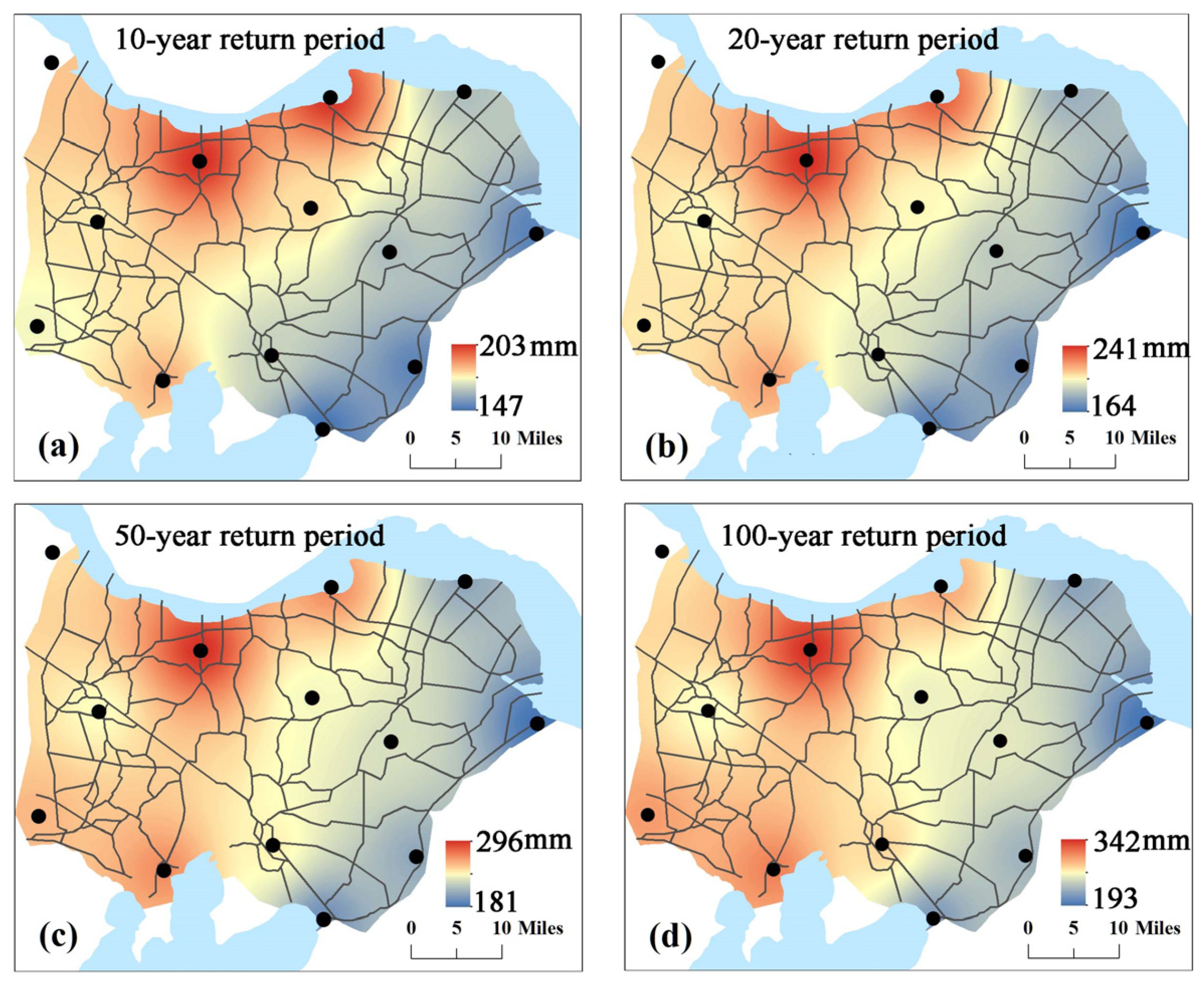
3.1.2. Scenario Setting
3.2. Impact of Changes in Connectivity Modes on Flood Processes
3.2.1. Water Level Processes at Representative Stations
3.2.2. Spatial Variations in Flood Signatures
3.3. Variations in Flood Intensity Severity Influenced by Different Connectivity Modes
4. Discussion
4.1. Method Design
4.2. Implication and Limitation
5. Conclusions
- (1)
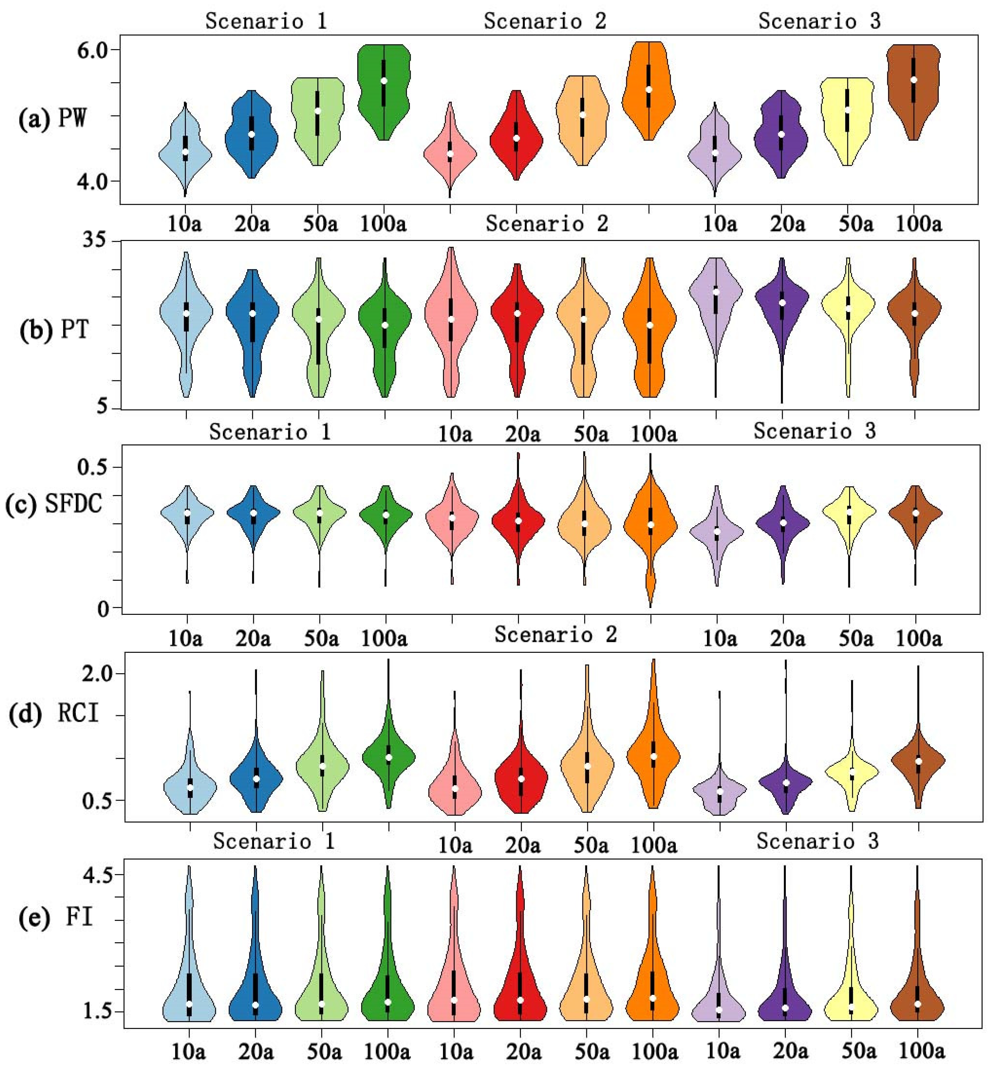
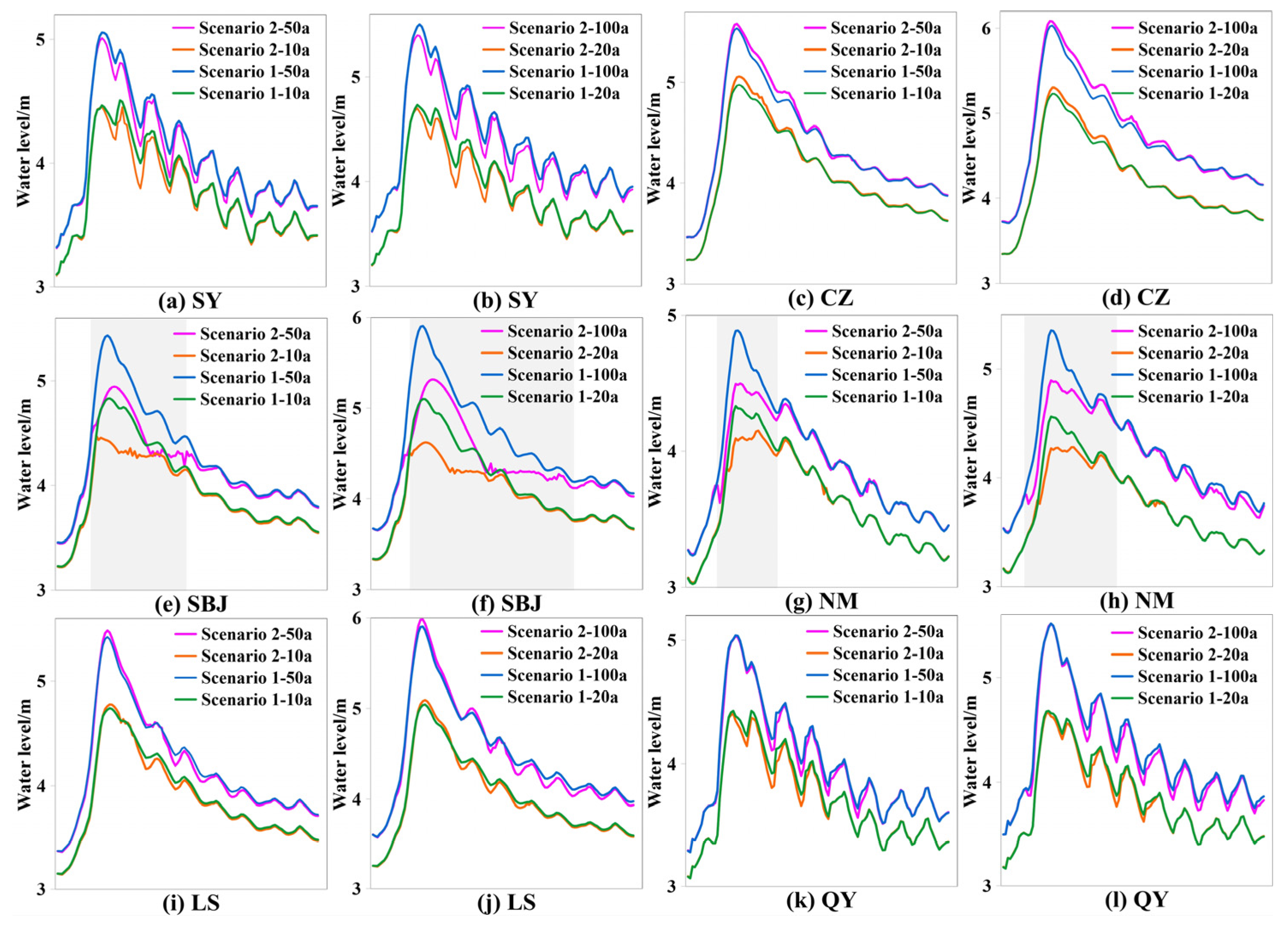
- As rainstorm intensity increases (from 10-year to 100-year events), significant strengthening is observed in flood peaks and RCI values under the three connectivity modes, accompanied by a notable shortening of peak occurrence times. Compared to RCI and SFDC, FI is less variable across the three connectivity modes. After changes in river network connectivity, alterations in flood characteristics are primarily concentrated in the Qingyang–Chenshu area, Changzhou core area, and regions along the river.
- (2)
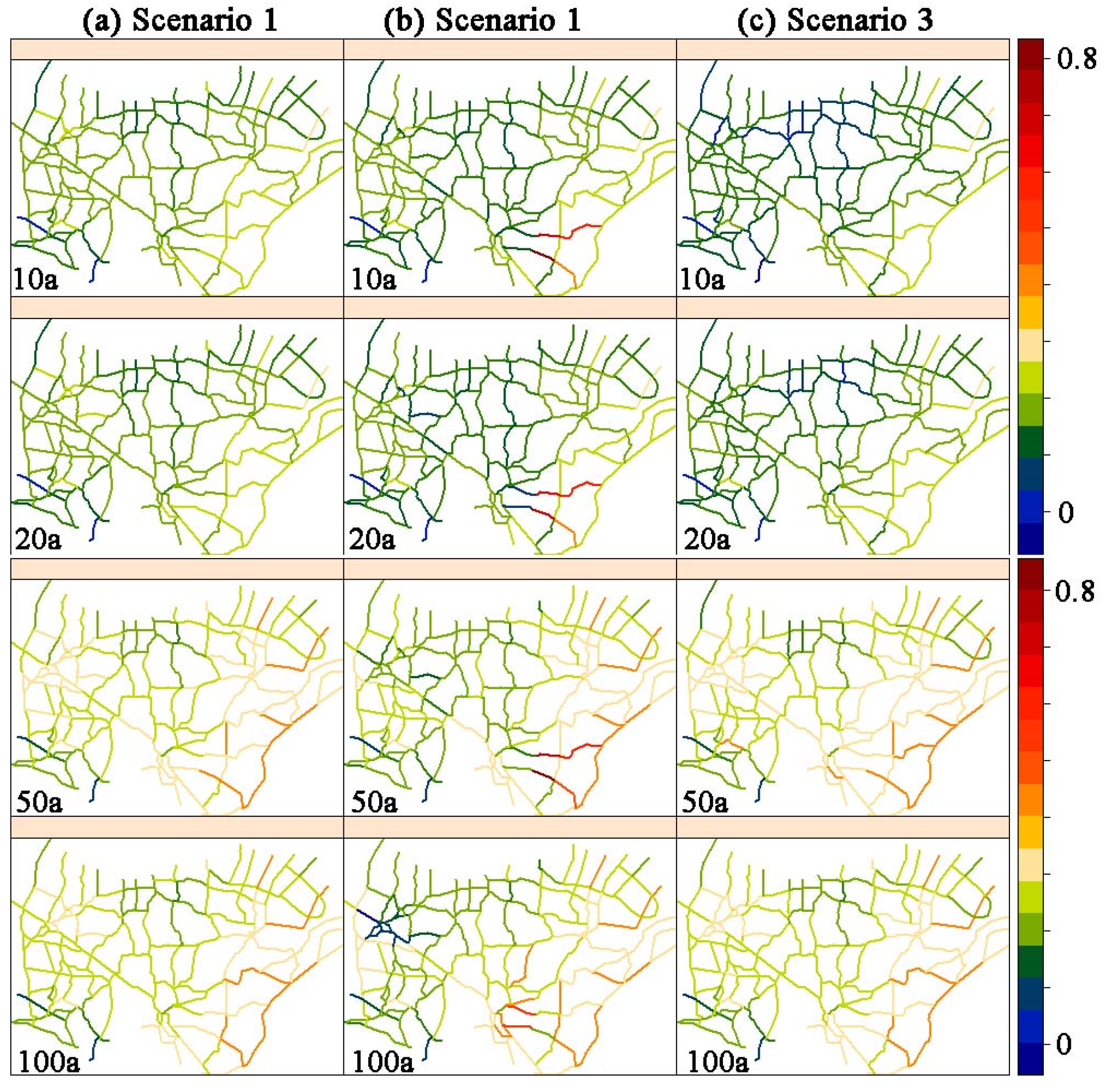
- Compared to the natural river network connectivity mode, changes in urban connectivity resulted in a 3–37% decrease in RCI values for storms with varying return periods, with the rate of change increasing alongside the return period. Changes in watershed connectivity led to an 18–38% reduction in RCI values. Changes in urban connectivity significantly affected the SFDC in the Changzhou core area of influence under high-magnitude storm conditions (100-year rainfall), resulting in a 61% decrease in the SFDC in this area. Conversely, under high-magnitude storm conditions, changes in river network connectivity within and outside the watershed had little effect on SFDC values.
- (3)
- The region experiences high flood severity levels under the natural river network connectivity condition. More than 80% of the rivers in the region exhibit high flood severity levels (Level III or higher). Following the activation of flood protection projects, changes in river network connectivity have led to a significant reduction in flood intensity severity in the region, with 85% to 91% of the rivers exhibiting the lowest flood severity of Level I. While rivers within the Changzhou urban area are protected from flooding under the 100-year storm scenario, rivers outside the Changzhou urban area continue to exhibit higher flood severity.
Supplementary Materials
Author Contributions
Funding
Data Availability Statement
Conflicts of Interest
References
- Zhang, Y.; Huang, C.; Zhang, W.; Chen, J.; Wang, L. The concept, approach, and future research of hydrological connectivity and its assessment at multiscales. Environ. Sci. Pollut. Res. 2021, 28, 52724–52743. [Google Scholar] [CrossRef] [PubMed]
- Michalek, A.T.; Villarini, G.; Husic, A. Climate change projected to impact structural hillslope connectivity at the global scale. Nat. Commun. 2023, 14, 6788. [Google Scholar] [CrossRef]
- Li, Y.; Tan, Z.; Zhang, Q.; Liu, X.; Chen, J.; Yao, J. Refining the concept of hydrological connectivity for large floodplain systems: Framework and implications for eco-environmental assessments. Water Res. 2021, 195, 117005. [Google Scholar] [CrossRef] [PubMed]
- Zhang, C.; Kuai, S.; Tang, C.; Zhang, S. Evaluation of hydrological connectivity in a river floodplain system and its influence on the vegetation coverage. Ecol. Indic. 2022, 144, 109445. [Google Scholar] [CrossRef]
- Serra-Llobet, A.; Jähnig, S.C.; Geist, J.; Kondolf, G.M.; Damm, C.; Scholz, M.; Schmitt, R. Restoring rivers and floodplains for habitat and flood risk reduction: Experiences in multi-benefit floodplain management from California and Germany. Front. Environ. Sci. 2022, 9, 778568. [Google Scholar] [CrossRef]
- Ren, M.; Zhang, Q.; Yang, Y.; Wang, G.; Xu, W.; Zhao, L. Research and application of reservoir flood control optimal operation based on improved genetic algorithm. Water 2022, 14, 1272. [Google Scholar] [CrossRef]
- Su, C.; Wang, P.; Yuan, W.; Cheng, C.; Zhang, T.; Yan, D.; Wu, Z. An MILP based optimization model for reservoir flood control operation considering spillway gate scheduling. J. Hydrol. 2022, 613, 128483. [Google Scholar] [CrossRef]
- Wang, K.; Wang, Z.; Liu, K.; Cheng, L.; Bai, Y.; Jin, G. Optimizing flood diversion siting and its control strategy of detention basins: A case study of the Yangtze River, China. J. Hydrol. 2021, 597, 126201. [Google Scholar] [CrossRef]
- Wang, L. Research on Coordination of Flood Control in the Taihu Basin under Rapid Urbanization. Ph.D. Dissertation, Nanjing Hydraulic Research Institute, Nanjing, China, 2019. (In Chinese). [Google Scholar]
- Xu, Y.; Xu, Y.P.; Wang, Q.; Wang, Y.F.; Gao, C. Spatial diversion and coordination of flood water for an urban flood control project in Suzhou, China. Water Sci. Eng. 2024, 17, 108–117. [Google Scholar] [CrossRef]
- Xia, J.; Chen, J. A new era of flood control strategies from the perspective of managing the 2020 Yangtze River flood. Sci. Sin. Terrae 2021, 64, 1–9. [Google Scholar] [CrossRef]
- Qi, W.; Ma, C.; Xu, H.; Chen, Z.; Zhao, K.; Han, H. A review on applications of urban flood models in flood mitigation strategies. Nat. Hazards 2021, 108, 31–62. [Google Scholar] [CrossRef]
- Liu, Y.; Huang, X.; Yang, H. An integrated approach to investigate the coupling coordination between urbanization and flood disasters in China. J. Clean. Prod. 2022, 375, 134191. [Google Scholar] [CrossRef]
- Zhou, Z.; Liu, S.; Zhong, G.; Cai, Y. Flood disaster and flood control measurements in Shanghai. Nat. Hazards Rev. 2016, 18, B5016001. [Google Scholar] [CrossRef]
- Yu, Z.; Lu, M.; Xu, Y.; Wang, Q.; Lin, Z.; Luo, S. Network structure and stability of the river connectivity in a rapidly urbanizing region. Sci. Total Environ. 2023, 894, 165021. [Google Scholar] [CrossRef]
- Lu, M.; Xu, Y.; Liu, P.; Lin, Z. Measuring the hydrological longitudinal connectivity and its spatial response on urbanization in delta plains. Ecol. Indic. 2020, 119, 106845. [Google Scholar] [CrossRef]
- Scordo, F.; Seitz, C.; Fiorenza, J.E.; Piccolo, M.C.; Perillo, G.M. Human impact changes hydrological connectivity in a Patagonian fluvial basin. J. Hydrol. Reg. Stud. 2023, 45, 101315. [Google Scholar] [CrossRef]
- Deng, X.; Xu, Y.; Han, L. Impacts of human activities on the structural and functional connectivity of a river network in the Taihu Plain. Land Degrad. Dev. 2018, 29, 2575–2588. [Google Scholar] [CrossRef]
- Grill, G.; Lehner, B.; Thieme, M.; Geenen, B.; Tickner, D.; Antonelli, F.; Zarfl, C. Mapping the world’s free-flowing rivers. Nature 2019, 569, 215–221. [Google Scholar] [CrossRef] [PubMed]
- Julian, J.P.; Wilgruber, N.A.; de Beurs, K.M.; Mayer, P.M.; Jawarneh, R.N. Long-term impacts of land cover changes on stream channel loss. Sci. Total Environ. 2015, 537, 399–410. [Google Scholar] [CrossRef]
- Han, L.; Xu, Y.; Lei, C.; Yang, L.; Deng, X.; Hu, C.; Xu, G. Degrading river network due to urbanization in Yangtze River Delta. J. Geogr. Sci. 2016, 26, 694–706. [Google Scholar] [CrossRef]
- Zhang, S.; Guo, Y.; Wang, Z. Correlation between flood frequency and geomorphologic complexity of rivers network–a case study of Hangzhou China. J. Hydrol. 2015, 527, 113–118. [Google Scholar] [CrossRef]
- Lu, M.; Kang, C.; Yu, Z.; Zhang, X. Coordination of flood control under urbanization on the Taihu Plain: Basin, city and region perspectives. Water 2023, 15, 3723. [Google Scholar] [CrossRef]
- Aredo, M.R.; Hatiye, S.D.; Pingale, S.M. Modeling the rainfall-runoff using MIKE 11 NAM model in Shaya catchment, Ethiopia. Model. Earth Syst. Environ. 2021, 7, 2545–2551. [Google Scholar] [CrossRef]
- Liu, Z.; Cai, Y.; Wang, S.; Lan, F.; Wu, X. Small and medium-scale river flood controls in highly urbanized areas: A whole region perspective. Water 2020, 12, 182. [Google Scholar] [CrossRef]
- Westerberg, I.; Wagener, T.; Coxon, G.; Mcmillan, H.; Castellarin, A.; Montanari, A.; Freer, J. Uncertainty in hydrological signatures for gauged and ungauged catchments. Water Resour. Res. 2016, 52, 1847–1865. [Google Scholar] [CrossRef]
- Tarasova, L.; Basso, S.; Zink, M.; Merz, R. Exploring controls on rainfall-runoff events: 1. Time series-based event separation and temporal dynamics of event runoff response in Germany. Water Resour. Res. 2018, 54, 7711–7732. [Google Scholar] [CrossRef]
- Painter, T.H.; Skiles, S.M.; Deems, J.S.; Brandt, W.T.; Dozier, J. Variation in rising limb of Colorado River snowmelt runoff hydrograph controlled by dust radiative forcing in snow. Geophys. Res. Lett. 2018, 45, 797–808. [Google Scholar] [CrossRef]
- Sawicz, K.; Wagener, T.; Sivapalan, M.; Troch, P.A.; Carrillo, G. Catchment classification: Empirical analysis of hydrologic similarity based on catchment function in the eastern USA. Hydrol. Earth Syst. Sci. 2011, 15, 2895–2911. [Google Scholar] [CrossRef]
- Chouaib, W.; Caldwell, P.V.; Alila, Y. Regional variation of flow duration curves in the eastern United States: Process-based analyses of the interaction between climate and landscape properties. J. Hydrol. 2018, 559, 327–346. [Google Scholar] [CrossRef]
- Ghotbi, S.; Wang, D.; Singh, A.; Mayo, T.; Sivapalan, M. Climate and landscape controls of regional patterns of flow duration curves across the continental United States: Statistical approach. Water Resour. Res. 2020, 56, e2020WR028041. [Google Scholar] [CrossRef]
- Baker, D.B.; Richards, R.P.; Loftus, T.T.; Kramer, J.W. A new flashiness index: Characteristics and applications to midwestern rivers and streams 1. JAWRA J. Am. Water Resour. Assoc. 2004, 40, 503–522. [Google Scholar] [CrossRef]
- Liang, W.; Yongli, C.; Hongquan, C.; Daler, D.; Jingmin, Z.; Juan, Y. Flood disaster in Taihu Basin, China: Causal chain and policy option analyses. Environ. Earth Sci. 2011, 63, 1119–1124. [Google Scholar] [CrossRef]
- Lu, P.; Smith, J.A.; Lin, N. Spatial characterization of flood magnitudes over the drainage network of the Delaware River basin. J. Hydrometeorol. 2017, 18, 957–976. [Google Scholar] [CrossRef]
- Nied, M.; Schröter, K.; Lüdtke, S.; Nguyen, V.D.; Merz, B. What are the hydro-meteorological controls on flood characteristics? J. Hydrol. 2017, 545, 310–326. [Google Scholar] [CrossRef]
- Huang, K.; Chen, L.; Zhou, J.; Zhang, J.; Singh, V.P. Flood hydrograph coincidence analysis for mainstream and its tributaries. J. Hydrol. 2018, 565, 341–353. [Google Scholar] [CrossRef]
- Becker, P. Dependence, trust, and influence of external actors on municipal urban flood risk mitigation: The case of Lomma Municipality, Sweden. Int. J. Disaster Risk Reduct. 2018, 31, 1004–1012. [Google Scholar] [CrossRef]
- Le, P.D.; Leonard, M.; Westra, S. Spatially dependent flood probabilities to support the design of civil infrastructure systems. Hydrol. Earth Syst. Sci. 2019, 23, 4851–4867. [Google Scholar] [CrossRef]
- Wang, Q.; Xu, Y.; Cai, X.; Tang, J.; Yang, L. Role of underlying surface, rainstorm and antecedent wetness condition on flood responses in small and medium sized watersheds in the Yangtze River Delta region, China. Catena 2021, 206, 105489. [Google Scholar] [CrossRef]

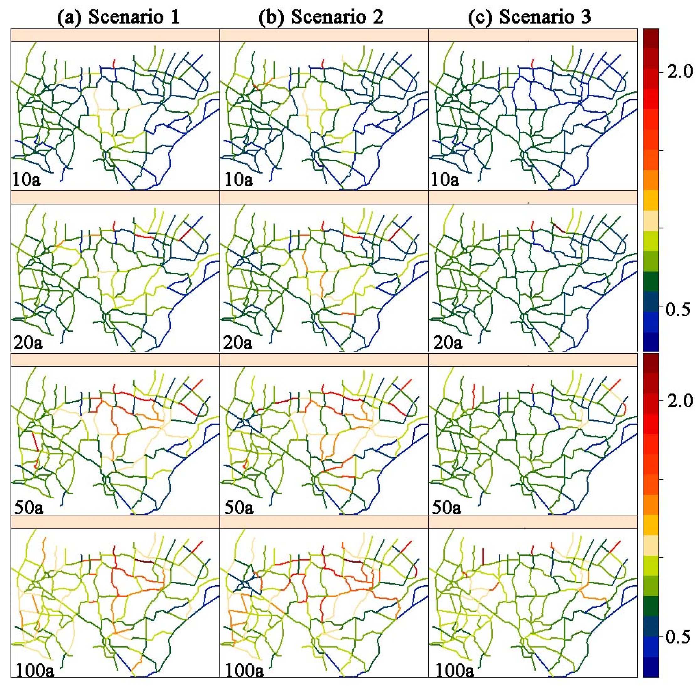

| Scenario 1 | Variations between Scenario 2 vs. Scenario 1 (%) | Variations between Scenario 3 vs. Scenario 1 (%) | ||||||||||
|---|---|---|---|---|---|---|---|---|---|---|---|---|
| Region | 10a | 20a | 50a | 100a | 10a | 20a | 50a | 100a | 10a | 20a | 50a | 100a |
| Chenshu–Qingyang | 0.74 | 0.86 | 1.19 | 1.22 | 14.6 | 2.5 | −3.4 | 8.0 | −21 | −18 | −38 | −25 |
| Changzhou core region | 0.64 | 0.68 | 0.80 | 0.89 | −3 | −24 | −28 | −37 | −2.5 | −0.2 | −3.4 | −2.5 |
| Along Yangtze River | 0.68 | 0.89 | 1.12 | 1.14 | 5.0 | 0.0 | 1.1 | −0.7 | −6.9 | −9.5 | −17 | −7.2 |
| Scenario 1 | Variations between Scenario 2 vs. Scenario 1 (%) | Variations between Scenario 3 vs. Scenario 1 (%) | ||||||||||
|---|---|---|---|---|---|---|---|---|---|---|---|---|
| Region | 10a | 20a | 50a | 100a | 10a | 20a | 50a | 100a | 10a | 20a | 50a | 100a |
| Chenshu–Qingyang | 0.29 | 0.29 | 0.29 | 0.29 | −3.6 | −4.4 | −4.4 | −1.5 | −32 | −21 | 0.1 | 0.9 |
| Changzhou core region | 0.36 | 0.36 | 0.36 | 0.35 | −4.2 | −8.0 | −23 | −61 | −19 | −12 | −0.4 | 1.5 |
| Along Yangtze River | 0.30 | 0.30 | 0.31 | 0.30 | 0 | 0 | 0 | 0 | −12 | −10 | −5.0 | −2.6 |
Disclaimer/Publisher’s Note: The statements, opinions and data contained in all publications are solely those of the individual author(s) and contributor(s) and not of MDPI and/or the editor(s). MDPI and/or the editor(s) disclaim responsibility for any injury to people or property resulting from any ideas, methods, instructions or products referred to in the content. |
© 2024 by the authors. Licensee MDPI, Basel, Switzerland. This article is an open access article distributed under the terms and conditions of the Creative Commons Attribution (CC BY) license (https://creativecommons.org/licenses/by/4.0/).
Share and Cite
Lu, M.; Wan, B.; Zhang, X.; Yu, Z.; Peng, Z.; Fu, X.; Xu, P.; Yao, Q. Impacts of River Network Connectivity on Flood Signatures and Severity Regulated by Flood Control Projects. Water 2024, 16, 2390. https://doi.org/10.3390/w16172390
Lu M, Wan B, Zhang X, Yu Z, Peng Z, Fu X, Xu P, Yao Q. Impacts of River Network Connectivity on Flood Signatures and Severity Regulated by Flood Control Projects. Water. 2024; 16(17):2390. https://doi.org/10.3390/w16172390
Chicago/Turabian StyleLu, Miao, Bin Wan, Xiuhong Zhang, Zhihui Yu, Zhuoyue Peng, Xiaolei Fu, Pengcheng Xu, and Qianrong Yao. 2024. "Impacts of River Network Connectivity on Flood Signatures and Severity Regulated by Flood Control Projects" Water 16, no. 17: 2390. https://doi.org/10.3390/w16172390
APA StyleLu, M., Wan, B., Zhang, X., Yu, Z., Peng, Z., Fu, X., Xu, P., & Yao, Q. (2024). Impacts of River Network Connectivity on Flood Signatures and Severity Regulated by Flood Control Projects. Water, 16(17), 2390. https://doi.org/10.3390/w16172390


