1. Introduction
Water resources are fundamental to human survival and social development, serving as a critical guarantee for maintaining ecological health. Under the combined influences of climate change, accelerated urbanization, and rapid population growth, the conflict between water supply and demand is becoming increasingly pronounced, characterized by a decrease in supply and an increase in demand [
1].
The impact of water scarcity is especially severe in arid regions, where it not only threatens public health and hampers regional economic growth [
2] but also constrains food production, ecosystem functions, and urban development [
3]. Meanwhile, the United Nations predicts that the global urbanization rate will reach 68% by 2025. While the accelerated pace of urbanization injects new vitality into urban economic development, it also poses threats to the ecological environment [
4], further highlighting the urgency of water resource management [
5]. Under the conditions of limited water resources, it has become a serious challenge for all countries to realize the sustainable development of society and the harmonious evolution of the ecological environment. Judging the capacity of regional water resources to support socio-economic development and environmental protection and planning urban water allocation and development within carrying capacity constitute a crucial strategy to address the water resource crisis [
6]. Evaluating water resources carrying capacity (WRCC) in arid areas is particularly urgent as it is key to ensuring water security, promoting ecological civilization, and achieving sustainable social development.
Yulin City, located in northwestern China, faces multiple challenges in its current development. Its industrial structure is generally at a low to medium level, with uneven urban–rural development and weak industrial chain competitiveness. Yulin City is under dual pressure from resource exploitation and ecological protection, especially in water resource management, where there are significant challenges and potential risks of secondary desertification. Additionally, there are notable shortcomings in livelihood areas, with overall low resident income levels and substantial tasks in improving social welfare and construction. Given the complexity and sensitivity of water resources in Yulin City, its WRCC is more susceptible to external influences [
7]. As a microcosm of water resources and ecological protection in Northwest China, the study of Yulin City’s water resources carrying capacity is typical and can provide a reference for similar regions. Meanwhile, to face the challenges of water shortage and ecological degradation brought about by global climate change and rapid economic development in the region, it is urgent and necessary to study the carrying capacity of its water resources. Therefore, evaluating the WRCC of Yulin City and accurately understanding its current state and potential will not only provide a scientific basis and direction for regional planning, spatial balance, and future development goals but also offer strong support for local water resource management and ecological protection.
WRCC is a crucial indicator for assessing whether regional water resources can sustain the population, economy, and environmental sustainability [
8]. Currently, there are two main perspectives on the concept: the first emphasizes the capacity for water resource development, referring to the maximum scale of water resource utilization that can support economic development without harming the environment. The second focuses on the sustainable support capacity of water resources, defining WRCC as the maximum water resource capacity for achieving regional sustainable development.
Since water resources inherently support multiple systems, their carrying capacity evaluation is inevitably influenced by factors such as resources, the population, the economy, and the ecological environment. When constructing evaluation index systems and choosing evaluation methods, regional differences, data acquisition difficulty, and specific research objectives must be fully considered. Presently, there is no unified and standardized index system or evaluation method in this field, leading to significant uncertainty in indicator selection and subjective influence on evaluation results. Notably, many studies tend to focus excessively on the water resource system itself, neglecting the comprehensive consideration of other supporting systems [
9]. This approach may result in WRCC assessment outcomes that deviate from the core concept, failing to accurately reflect the true carrying capacity of regional water resources. Therefore, to more accurately and reasonably evaluate the WRCC of a region, it is necessary to construct a comprehensive, multi-system index system and employ objective, scientific methods to accurately evaluate the regional WRCC.
Numerous scholars have explored WRCC research methods, conducting quantitative evaluations based on various assessment index systems by constructing different models. These models have evolved from single-indicator evaluations to multi-factor evaluations. Moreover, the evaluation perspectives have expanded from single-system analyses to coupled analyses of complex systems, attempting to delve into the internal mechanisms and understand how system dynamics drive WRCC. However, multi-factor evaluations of complex systems face several challenges in practice, such as the difficulty of obtaining data in remote areas, the uncertainty of key factors, and similar challenges. Consequently, many researchers currently use comprehensive indicators to evaluate WRCC and select evaluation models based on the actual conditions of the region. Presently, methods such as the PVAR model [
10], entropy weight method [
11], fuzzy comprehensive evaluation model [
12], TOPSIS model [
13], SD model [
12,
14], and principal component analysis (PCA) [
15] are widely applied in constructing and evaluating WRCC indicators. Although these methods provide quantitative evaluation results for regional WRCC, factors such as regional differences and the complexity of evaluation indicators make it challenging to directly translate these model evaluation results into specific recommendations or feasible paths for regional development planning. This limitation reduces the reference value when formulating region-specific development strategies.
Therefore, it is crucial to further identify the driving factors behind the evolution of regional WRCC based on quantitative evaluations. Scholars have tried using various methods in different regions to explore the main driving factors and their mechanisms for WRCC, including the geographically and temporally weighted regression (GTWR) model [
16], the obstacle degree model [
17], and principal component analysis [
18]. However, these methods have certain limitations in addressing spatial heterogeneity and indicator correlation. To overcome these limitations, the recently proposed Geodetector model has demonstrated unique advantages in WRCC driving force research. It can more comprehensively consider spatial heterogeneity and indicator correlation, complementing the deficiencies of other methods [
19].
This study constructed a WRCC evaluation model that encompasses the population and society, economic development, and ecological environment systems. It investigated the internal mechanisms of the WRCC system by coupling an improved fuzzy comprehensive evaluation model based on the entropy weight method with the TOPSIS model to evaluate the WRCC of 12 counties and districts in Yulin City from 2011 to 2020. The affiliation function of the fuzzy comprehensive evaluation method was optimized to minimize the subjective influence, and the spatiotemporal evolution of regional WRCC patterns was explored. The Geodetector method was employed to analyze the intrinsic driving factors of WRCC spatiotemporal evolution in Yulin City from both single-factor and interactive-factor perspectives. The research results aim to provide a comprehensive and reasonable evaluation of the current WRCC in Yulin City and support regional water resource planning and management policies.
2. Study Area and Methods
To study the WRCC of Yulin City and explore its main driving factors, this research establishes a framework consisting of three main modules: (1) The Determination of Regional WRCC Evaluation Indicators; (2) Analysis of the Spatiotemporal Evolution of WRCC; and (3) Analysis of Main Driving Factors. Based on the fundamental characteristics of the region, relevant factors influencing WRCC will be investigated. Quantitative scoring and ranking of WRCC will be conducted to explore its spatiotemporal patterns and discuss development differences between different areas within the region. Finally, the main drivers of WRCC in the region are identified to analyze the regional development path, aiming to improve WRCC based on securing economic development.
2.1. Study Area
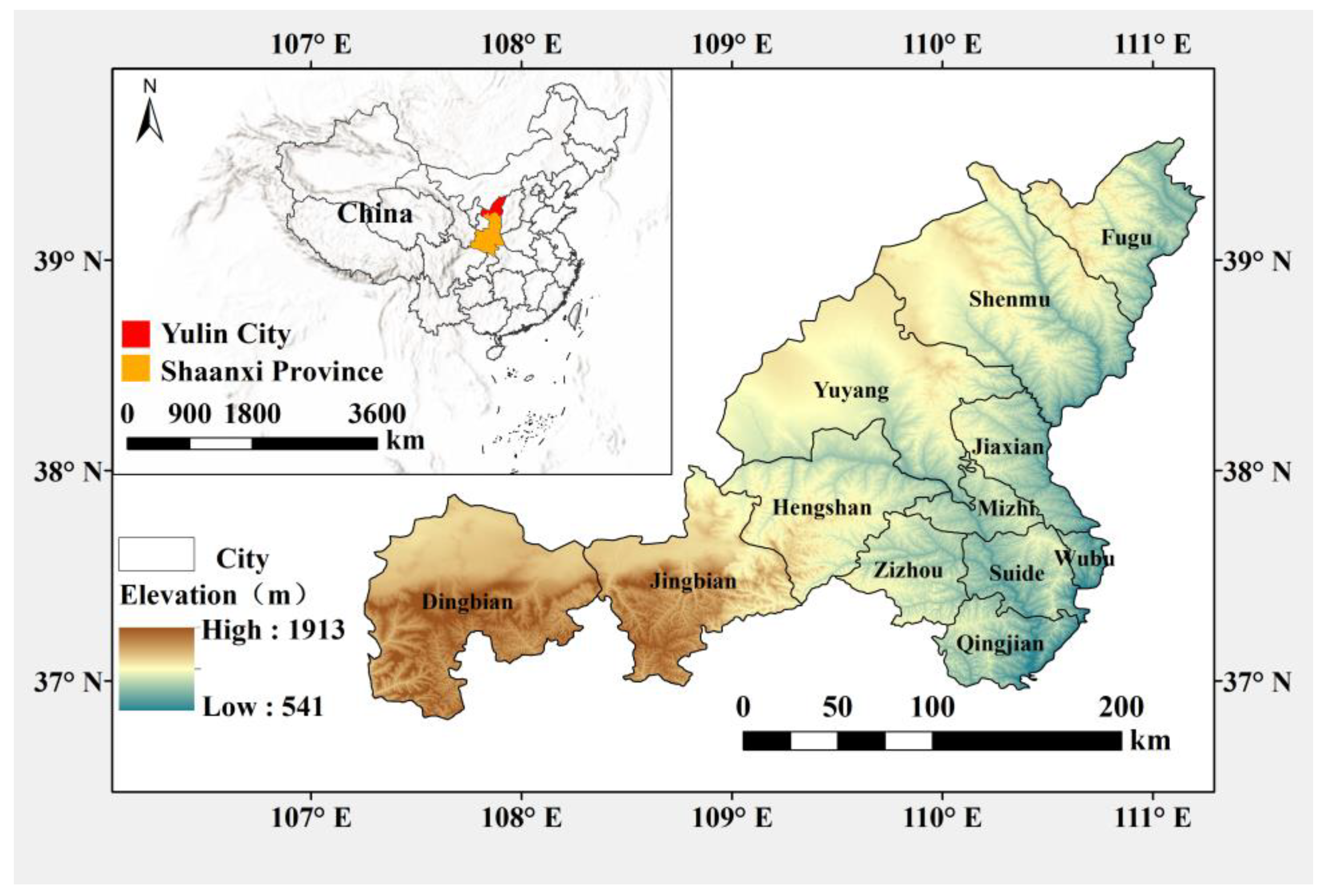
This study selects Yulin City, Shaanxi Province, China (36°57′~39°35′ N, 107°28′~111°15′ E) as the research area (
Figure 1). Yulin City is located on the Loess Plateau in northwest China, with a total area of 42,920.20 km
2, making it the largest prefecture-level city in Shaanxi Province, encompassing 1 county-level city, 2 districts, and 9 counties. As of 2022, Yulin City has a permanent population of 3.6161 million and a regional GDP of 654.365 billion yuan, highlighting its significant regional resource advantages, particularly in coal, gas, oil, and salt resources.
The region is a typical ecological transition zone, with the northern part characterized by wind–sand grasslands, covering 42% of the area, and the southern part by hilly terrain on the Loess Plateau, covering 58%. The overall area faces severe soil erosion. Additionally, the region has an average annual precipitation of 393.90 mm, and the per capita water resources amount to 740 m
3, only 33% of the Chinese average and below the internationally recognized water scarcity threshold of 1000 m
3 per capita [
20]. Moreover, the fragmented terrain exacerbates soil erosion, making water resources difficult to develop and utilize effectively. Water scarcity has become a bottleneck for regional economic and social development and the construction of ecological civilization in Yulin City, hindering its transition from high-speed to high-quality economic development.
2.2. Data Collection
This study collected original data on various factors from 2011 to 2020 for 12 counties and districts (including county-level cities) in Yulin City. The data sources for economic and social development factors primarily include the “Statistical Yearbook of Yulin City” and the “Statistical Bulletin of National Economy and Social Development of Yulin City” (
http://tjj.yl.gov.cn/list/tjgb, accessed on 20 April 2024). Data related to water resources and ecological environment factors, including water usage, were sourced from the “Water Resources Bulletin of Yulin City” (
http://slj.yl.gov.cn/d-show-528.html, accessed on 20 April 2024) and other officially published datasets. Some factors were derived from original data calculations; for instance, the ecological environment water usage rate was calculated as the ecological environment water consumption divided by the total water consumption.
2.3. WRCC Evaluation System and Indicator Determination
The relationship between WRCC and urban development, as well as the natural endowment of water resources, forms the underlying framework of regional WRCC, which is intricately intertwined with various complex systems. Quantitative assessment of WRCC enables an objective evaluation of the prospects for sustainable development and utilization of water resources. Based on the evaluation results, adjustments and responses can be made to the layout and regulation of the regional ecological environment and socio-economic development to achieve spatial balance and sustainable development. Establishing a comprehensive and systematic indicator system [
16] is essential to ensure objective evaluation of regional WRCC. Therefore, this study begins with WRCC and focuses on three subsystems: the population and social system, the economic development system, and the ecological environment system. These choices are made based on regional characteristics and data availability [
21,
22]. Within these three systems, 15 potential evaluation factors for regional WRCC were initially selected. Using the Friedman test, KMO test, and Bartlett’s spherical test, correlation analysis and information contribution rate analysis were conducted to validate the effectiveness of the indicators and eliminate redundant information. Finally, 10 indicators were determined to constitute the WRCC evaluation indicator system for this study.
2.4. Entropy Weight Method
Indicator weights can reflect the relative importance of different indicators, and determining these weights scientifically and reasonably is crucial for methodological soundness. Information entropy is a measure of the degree of uncertainty or confusion inherent in the data, and through the precise calculation of the information entropy value (i.e., entropy) of each evaluation indicator, it is possible to quantify the degree of variation and uncertainty of these indicators in the evaluation system and achieve the determination of the weights of each indicator. The method applied in this process is the entropy weighting method. The entropy weight method can objectively determine the weights of indicators based on the judgment matrix composed of evaluation indicator values, using entropy values to reflect the importance of each indicator to the overall evaluation system [
8].
For the evaluation indicator system of WRCC, there are both positive and negative indicators. Positive indicators indicate that higher values lead to better evaluation results, while negative indicators work inversely. Additionally, the physical dimensional differences between indicators can influence the calculation results. Therefore, this study employs standardized linear interpolation to normalize both positive and negative indicators. We assume there are indicators: 1, 2,……, m; and each indicator has values, where represents the number of administrative regions.
For negative indicators:
where
represents the
-th indicator value of the
-th sample,
denotes the standardized and normalized value after dimensionless processing, and
-th and
-th are indices that distinguish between different indicators and samples, respectively. Furthermore, positive indicators signify that an increase in their values is advantageous to the evaluation outcome, whereas negative indicators exhibit the opposite effect.
Entropy can be used to measure its variability, computed as:
where
is the
-th entropy value and
,
represents the number of administrative regions,
> 0.
Entropy weight, determined by the entropy weighting method, is calculated as:
where
is the weight of the
-th indicator, with a total of 10 indicators used in this study.
2.5. Improved Fuzzy Comprehensive Evaluation Model
The fuzzy comprehensive evaluation model is a method based on the synthesis principle of fuzzy relationships, which quantifies difficult-to-quantify factors to achieve research on complex systems. It demonstrates outstanding performance in dealing with uncertainties, providing evaluation results that can qualitatively distinguish and quantitatively rank. This method is highly applicable to the evaluation of water resources carrying capacity, which itself is built upon multiple systems and indicators. This approach calculates the affiliation matrices of the different factors for the different levels of the target, establishing a fuzzy comprehensive evaluation result matrix. After normalization through weighted fuzzy vector operations, a comprehensive evaluation value can be obtained [
23].
In this study, the factor set = {1, 2,⋯⋯, m}, m = 10, and evaluation set V = [V1, V2,⋯⋯, Vn], = 3 are established. Using a linear change-based method to determine the degree of affiliation, we address the issue of leapfrogging that may occur in a single linear change, which can lead to subjective bias in results. In this paper, the membership degree of values falling at the midpoint of interval V2 is set to 1, while the membership degrees on both sides of the interval are set to 0.5. For the two marginal intervals V1 and V3, the affiliation degree increases for values farther away from the interval, with critical points set at 0.50. The critical values are defined as follows: for the boundary between V3 and V2, for the boundary between V2 and V1, and as the midpoint of interval V2. The determination of values adopts a dynamic adjustment method to eliminate the subjective partitioning impact of the evaluation set. For positive indicators, takes the minimum factor value, takes the average factor value, and takes the maximum factor value. For negative indicators, the opposite applies.
Taking positive indicators as an example, the affiliation function for each level is calculated as follows (inverse operations apply for negative indicators):
where
represents the original data matrix and
denotes the affiliation degree of each indicator for different levels.
According to the principle of fuzzy matrix operations, after normalization, the regional water resources carrying capacity score
is obtained using the formula:
where
is the matrix of indicator weights;
is the relative affiliation degree of the
-th factor in the
-th level of the evaluation set;
is the corresponding affiliation degree matrix; and
is the result of fuzzy operations.
The normalization formula is:
where
is the water resources carrying capacity score based on the fuzzy computation matrix. A higher
value indicates poorer water resources carrying capacity. For arid areas,
is typically set to 1.
is used to highlight the advantage level to enhance the distinguishability of the evaluation level scores. In this study,
is chosen accordingly.
represents the result of fuzzy relation operations.
2.6. The TOPSIS Model
Determining WRCC through a single method alone is challenging regarding validating its reasonableness. Therefore, this study opts to correct the evaluation results using the TOPSIS model, which offers advantages such as strong objectivity, clear mechanistic principles, scientific calculation, and computational simplicity. The basic principle of TOPSIS is based on the normalized original data matrix, where the optimal and worst solutions among limited options are identified. By computing the distances between the evaluation solutions and these optimal and worst solutions, the relative proximity of the evaluation object to the optimal solution is determined as the basis for evaluation. The model operates on the premise that the distance to the positive ideal solution is minimized while the distance to the negative ideal solution is maximized. This is achieved by calculating the Euclidean distance between each evaluation indicator and the critical threshold vectors, resulting in the ranking of regional WRCC based on proximity calculations [
24].
The normalized processed data
, multiplied by the entropy weight
for each evaluation indicator, yields the weighted evaluation data
. Here, the maximum value represents the positive ideal solution
, and the minimum value represents the negative ideal solution
. The formula for calculating the Euclidean distance between the positive and negative ideal solutions and the weighted evaluation data is as follows:
The formula for calculating proximity is as follows:
where
is the evaluation result of the TOPSIS model, with values ranging from 0 to 1, with closer to 1 representing better water carrying capacity.
2.7. Geodetector
Regional WRCC is influenced by multiple systems. For Yulin City, significant spatial differences in resources and social development exist among different districts. Additionally, rapid economic development over time also affects the driving forces impacting WRCC differently at different times. Geodetector has received widespread attention for exploring the driving forces behind WRCC and spatial balance, showing promising results in applications [
25]. Geodetector was proposed to detect spatial differentiation and underlying driving forces. Its core idea is that if an independent variable significantly affects a dependent variable, its spatial distributions should exhibit similarity. Geodetector calculates and compares q values of individual factors and their interaction values to determine whether there is interaction, and if so, the strength, direction, linearity, or non-linearity of the interaction [
26]. It includes modules for factor detection, interaction detection, risk monitoring, and ecological detection. This study focuses on the factor detection and interaction detection modules, using Geodetector to analyze the driving effects of different factors on the spatio-temporal pattern evolution of regional WRCC. The initial data of the dependent variables are classified into five categories using K-means clustering analysis as inputs for Geodetector.
The measurement q is commonly used to express detection results, and its expression is as follows:
where
represents the layer of variable
or factor
in this study,
represents the set of indicators influencing regional WRCC, and
signifies the quantitative assessment of the actual WRCC within that region.
and
are the number of units in layer
and in the entire region, respectively;
and
are the variances of variable
in layer
and in the entire region, respectively; and
is the explanatory power of independent variable
on dependent variable
, ranging from 0 to 1, where a higher value of
indicates stronger explanatory power of the corresponding factor on the dependent variable.
4. Discussion
4.1. Regional WRCC Development Differences
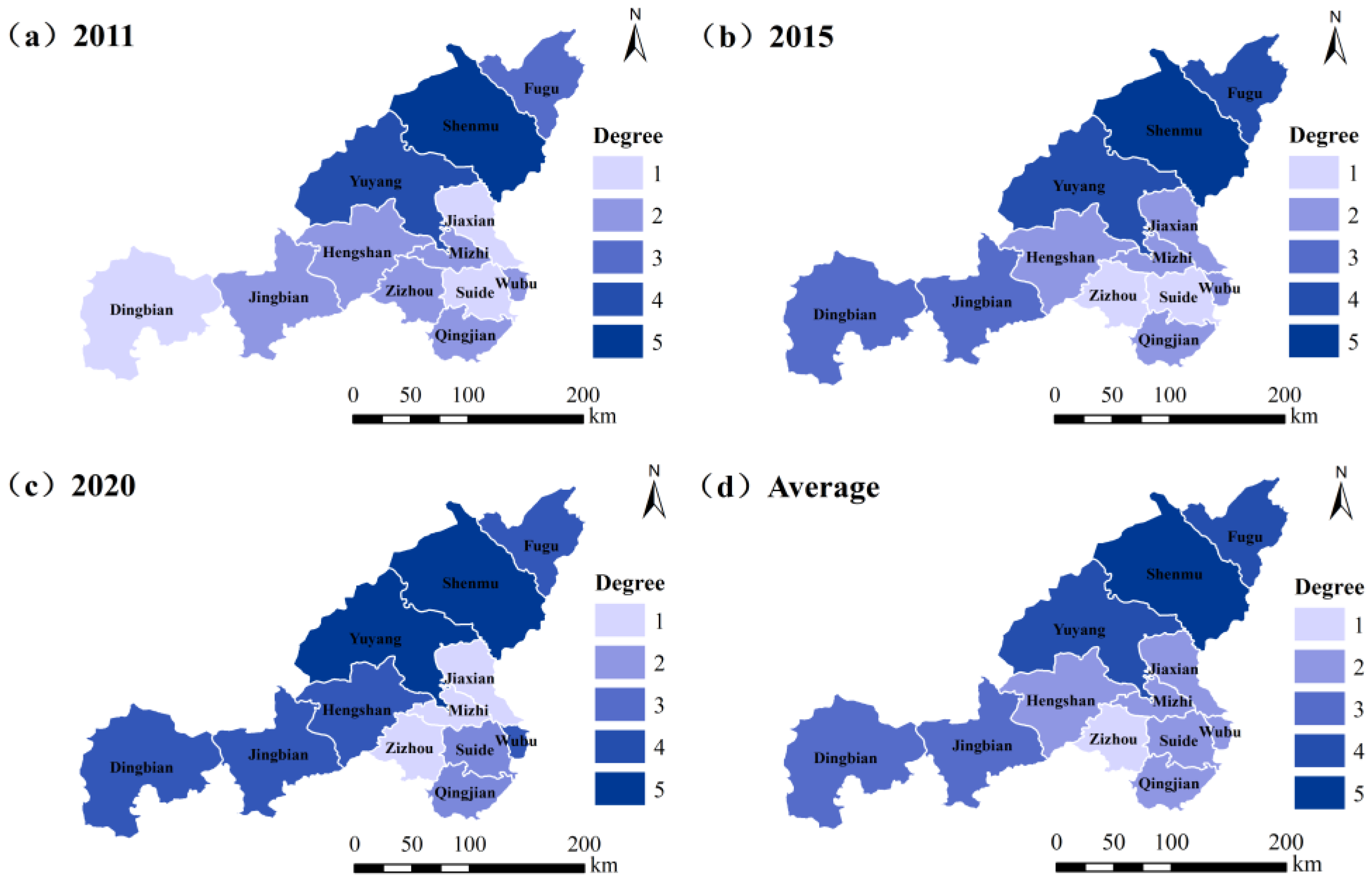
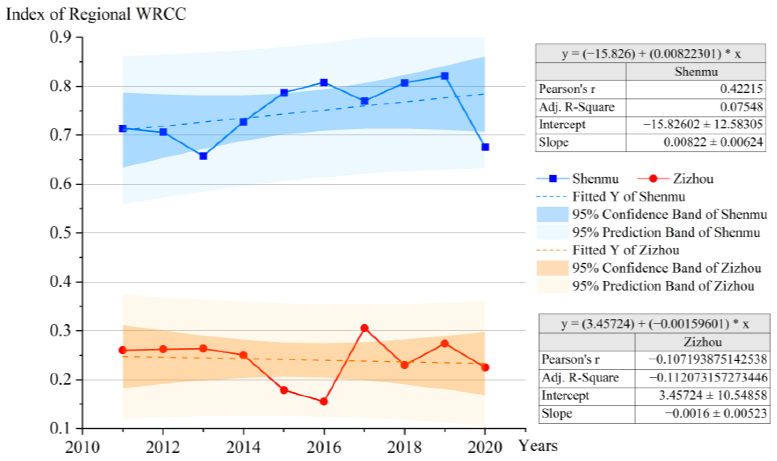
A comparative analysis of the WRCC evaluations of the best-performing Shenmu County-level City and the worst-performing Zizhou County (
Figure 10) highlights the disparities in their WRCC development. From 2011 to 2020, Shenmu’s average WRCC score was 0.75, achieving a V-level rating, indicating its potential to support sustainable water resource development and utilization in the future. The linear fit result for Shenmu shows a positive slope, suggesting an overall improving trend in its WRCC. The 95% confidence and prediction intervals stabilize between 0.55 and 0.90, demonstrating that its WRCC remains at a good level or higher.
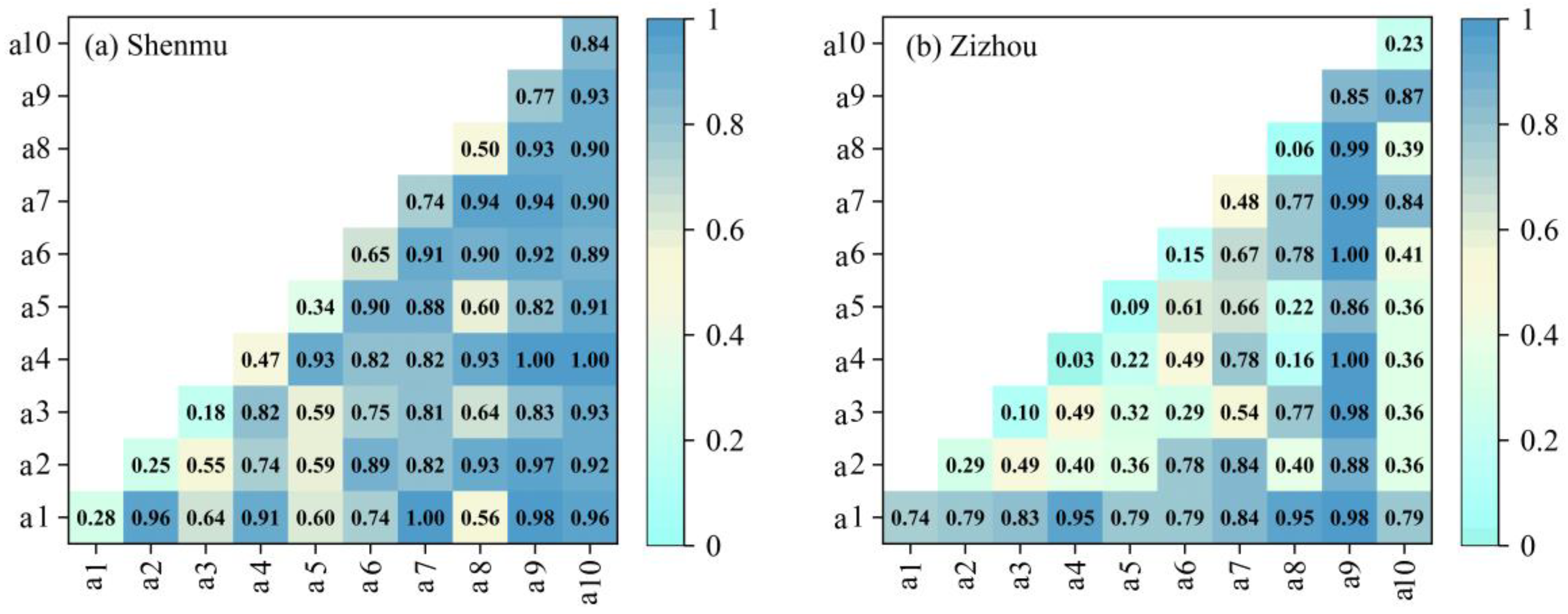
Geographically, Shenmu is located in the northern six counties, serving as the core area of the national northern Shaanxi energy and chemical industry base. It is not only a leading economic area in Shaanxi Province but also holds a significant position in the western country economies of China. In the analysis of driving factors, we found that the ecological environment water use rate and precipitation are the strongest single-element drivers. In the interaction of factors (
Figure 11), combinations such as the urbanization rate and total water resources, per capita GDP and precipitation, and per capita GDP and the ecological environment water use rate exhibit the strongest driving forces. In contrast, Zizhou County’s WRCC had an average score of 0.24 from 2011 to 2020, with a rating of only I-level, indicating that its WRCC urgently needs restoration and cannot continue to support development activities. The linear fit results for Zizhou County show a negative slope, revealing a declining trend in its WRCC. The 95% confidence and prediction intervals range from 0.10 to 0.40, indicating that its WRCC is far below the medium standard.
Located in the southern six counties, Zizhou County is an ecological function county and an agricultural development benchmark. The driving factors for its WRCC differ significantly from those of Shenmu City. In the single-element analysis, precipitation and urbanization rates show the strongest driving effects. In the interaction of factors, combinations of precipitation and per capita GDP, water consumption per unit area of irrigation, total water resources, and water supply form the strongest driving forces.
A common factor between the two regions is the strong driving force of precipitation, primarily due to the sensitivity of these arid areas to rainfall, aligning with the overall detection results of Yulin City. The arid zone is highly sensitive to precipitation, as it directly affects water supply and is critical for all water-demanding sectors such as agriculture and industry. In Zizhou County, as an agricultural area, precipitation is directly related to crop growth and agricultural harvests. Shenmu City, on the other hand, is highly urbanized but its economy is dependent on the fossil energy industry. Precipitation directly affects the cost of industrial water, and the high water consumption characteristics of the industry make the impact significant. At the same time, as the ecological environment has a greater impact on the carrying capacity of water resources, precipitation is indispensable in maintaining the ecological balance of the arid zone and is an important driver for the economy and ecology of Shenmu City. However, their differences are also evident. Shenmu City’s primary driving factors focus on the economic development system, particularly GDP-related indicators, where socio-economic development has boosted the WRCC. With economic prosperity, there is also an increased emphasis on ecological civilization construction, with government and enterprises committed to industrial transformation and clean production, positively supporting the improvement of WRCC.
On the other hand, Zizhou County is more influenced by ecological environment system factors. The agricultural development needs underscore the importance of ensuring a healthy ecological environment. However, due to its relatively low productivity, it struggles to support large-scale economic development, and its current WRCC is insufficient to meet the needs of social development. Therefore, accelerating industrial construction and achieving agricultural modernization may be effective ways to enhance Zizhou County’s WRCC.
4.2. Impact of Management Policies on Regional WRCC
This study thoroughly investigates the WRCC (WRCC) of Yulin City from 2011 to 2020. By constructing a mathematical model, the research systematically evaluates regional WRCC across three dimensions: population and society, economic development, and the ecological environment. A detailed analysis of the driving effects of various factors on the spatiotemporal distribution of WRCC has been conducted. The results of this evaluation aim to provide robust data support and strategic recommendations for relevant decision-makers and managers.
Based on the findings of this research, it is recommended that water resource management departments focus on regional water resource conditions. Building water diversion projects and other hydraulic infrastructure can achieve spatial equilibrium in water resource distribution. For areas with severely inadequate or weak WRCC, rapid adjustments in industrial structure are necessary to promote healthy and stable regional economic development. This should be performed while ensuring that the ecological environment remains unharmed and by fostering the development of industries with local characteristics. Conversely, regions currently exhibiting excellent WRCC should focus on improving water resource utilization efficiency, strictly controlling total pollutant discharge and water usage, and continuously strengthening ecological environment protection. Additionally, accelerating innovation in industrial structure is crucial to ensure that economic sustainable development is promoted while steadily enhancing WRCC, thereby fostering a virtuous cycle of regional sustainable development.
The Yulin city government should be sensitive to the dynamics of precipitation, which is a strong driving indicator, and plan and implement water allocation strategies based on these dynamics. Given the natural challenges of precipitation scarcity in arid regions, the government should actively promote and support water-saving technologies at the policy level. In agriculture, the focus should be on promoting drought-tolerant crop varieties and adjusting irrigation patterns to be more precise and efficient, reducing the high dependence of agriculture on precipitation fluctuations. Meanwhile, for industrial areas, the government should introduce incentives to promote water recycling across industries, agriculture, and urban sectors, which will not only help alleviate the pressure on water resources but is also crucial for achieving sustainable development. Furthermore, optimizing the city’s water supply network and upgrading drainage facilities will ensure that when precipitation fluctuates, the stability of the water supply system and the efficiency of the drainage system are both improved, thus maximizing water recycling efficiency. This series of initiatives aims to address and fulfill the strict management of regional water resources, including total volume control, water use efficiency improvement, and water functional area pollution limitation.
Yulin City has successfully transformed from an agricultural region to an industrial powerhouse and from a poverty-stricken area to a prosperous one, largely through the development and utilization of fossil resources. Various greening and restoration measures have also achieved significant success [
29]. However, Yulin City faces future sustainable development challenges, such as regional development imbalances, ecological environment degradation, and the urgency of industrial transformation. In planning for the future, the Yulin City government must increase investment in ecological environment protection, improve water use efficiency, and enhance regional WRCC through water diversion projects and water-saving measures to support sustainable social development.
4.3. Strengths and Limitations
This study focuses on Yulin City in Shaanxi Province, China, an area characterized by significant north–south differences. As a representative of typical arid regions and energy cities, Yulin’s need for socio-economic development and ecological environmental protection is particularly urgent. Currently, research on WRCC (WRCC) from a multi-system perspective at a small scale to guide future societal development is insufficient. Therefore, the results of this study are expected to provide valuable contributions to WRCC research in similar regions.
In terms of the research methodology, existing studies on WRCC often rely on a single method for spatial difference analysis and seldom address spatial correlation. To address this, our study integrates the fuzzy comprehensive evaluation method and the TOPSIS method for a comprehensive assessment. This approach effectively avoids the potential errors associated with a single method and enhances the rationality and scientific validity of the evaluation results. Additionally, this study employs Geodetector to deeply explore the main driving factors of WRCC. By comparing the results of the obstacle degree model’s driving factor detection analysis (using the year 2020 as an example, as shown in
Table 6), the Geodetector results are more distinctive and can significantly reflect the differentiation of regional WRCC driving factors. This achieves a systematic evaluation analysis from county to north–south to the entire city, forming a “point-line-surface” pattern. Furthermore, this study improves the affiliation function in the fuzzy comprehensive evaluation to address issues related to linear changes leading to transgressive phenomena and the subjectivity arising from interval setting.
Despite conducting a reasonable and objective evaluation analysis of Yulin’s WRCC and its driving factors from 2011 to 2020, some limitations remain. In terms of indicator selection, although the study fully considered regional conditions and referred to previous research, it was constrained by the available data. Future studies could increase the number of indicators to provide a more comprehensive evaluation of regional WRCC. This study primarily focuses on the current and past WRCC evaluation and lacks an in-depth exploration of the future evolution of WRCC. Therefore, future research is recommended to use machine learning and data-driven predictive models to study the evolution of future WRCC and to set up scenario simulations to explore the impact of different factors on future WRCC changes. Moreover, this study focuses on a relatively small research scale. Future studies could consider expanding the research scope to the Loess Plateau region or the middle and upper reaches of the Yellow River to comprehensively explore WRCC issues.
