2.1. Geological, Hydrogeological and Geomechanical Properties of the Rocks in the RTH Area
The Tertiary layers of the Zasavje coalfield extend in a long strip in a west-easterly direction. This belt of Tertiary sediments is known as the Laško-Zagorje Synclinorium, which is accompanied by the Trojane Synclinorium to the north and the Litija Anticlinorium to the south. This is a series of Tertiary rocks that are geologically bounded by faults or fault systems.
Together with the Laško mine, the Hrastnik mine forms the easternmost Tertiary depression, followed by the Ojstro, Trbovlje and Zagorje mines in the west [
8,
9].
The oldest rocks in the area under consideration are grey Permo-Carboniferous clastites and red and grey Gredenian clastites, which are found to the north and south of the Tertiary depression.
The Triassic rocks of the Trojane anticline consist of red siltstone, oolitic limestone and sandy micaceous dolomite from the Lower Scythian and dark grey, flat micritic limestone from the Upper Scythian.
These are followed in the lower part by stratified and sometimes laminated aniseed dolomite, which merges upwards into non-stratified sparitic dolomite with large lenticular conglomerate inclusions. The sparitic dolomite is followed by a layer of flat limestone with cherts and, above this, tuffaceous rocks with lenticular inclusions of limestone with cherts and sparitic dolomite. The tuff series is sometimes replaced by dark grey mudstone and chert. The upper part of this stack clearly belongs to the Lombard, while the lower part could be from the Fassano or even the Anisian. The contact with the Anisian of the classic dolomite facies is not visible. Above the tuffogenic stack lies the unstratified dolomite of the Ridge facies, probably of Cordevolian origin and covered by dark grey clastites several hundred metres thick. Based on the described development, we conclude that the tuffaceous stack with Cordevolian dolomite and dark grey clastics belongs to the Pseudozyl Formation. In the Litija anticline, Carnian carbonates with tuffaceous rocks occur in the lower part, while Sparitic dolomite, probably of Rhaetian age, and Norian limestone with megalodon shells occur in the upper part.
In the Oligocene, Tertiary sediments began to be deposited transgressively on the Triassic base. The conditions under which deposition took place changed rapidly, which is reflected in the different facies forms. We can even speak of three sedimentation cycles. The first sedimentation cycle is represented by carbonaceous layers together with Oligocene marine clays. The second sedimentation cycle begins with the deposition of the Miocene Gova layers. The third sedimentation cycle consists of the deposition of light layers.
The Oligocene consists of the bedrock (lower part of the coal-bearing layers), the coal layer, the overburden (upper part of the coal-bearing layers) and the marine clay (grey).
The lower part of the coal-bearing layers—the bedrock—consists mainly of clay and represents a fill that was deposited along the resulting depression, which received denuded material from the rising neighbouring areas. The thickness of the bedrock layers varies, reaching up to 80 m in some places. The bedrock layers are clastic, consisting of light grey clays (white bedrock), which in some places contain sand inclusions and even gravel layers. Towards the top, the bedrock becomes darker and gradually merges into the black bedrock and this into the coal layer.
The filling of the depression created a fairly wide plain on which a swamp forest developed in the last phase of sedimentation of the bedrock, providing material for the formation of coal. We separate the poorer part of the bedrock from the better part of the overburden of the coal layer. This is shown, among other things, by the fact that bedrock coal has more ash and a lower calorific value, while the overburden coal has the opposite, namely less ash, a lower density and a higher calorific value. In the bedrock part, the coal contains many clay admixtures and clay inclusions. The coal of the overburden part is unreasonably cleaner and of better quality, although it contains kaolinite and tuffite inclusions here and there. We should also point out pyrite and quartz concretions, which are actually pseudomorphs of the minerals mentioned after plant remains.
The upper parts of the coal-bearing layers are located in the lake or lagoon, where the overburden layers have formed, in particular the overburden marl, which is lithologically very different from the bedrock. In the lower part, they consist of black, thin-layered marl with many combustible organic admixtures, which merges upwards into brown, sometimes grey, hard limestone marl.
The grey marine clay was formed during subsidence, when the sea penetrated the lagoons and grey marly marine clay was deposited. The transition from carbonaceous layers to marine clay is gradual, with not even the slightest trace of discontinuity. This means that the subsidence that began with the deposition of the carbonaceous layers continued until the entire area was flooded by the sea and the lagoons became sea bays. The marine clay is not stratified and has a rich foraminifera fauna. It is, on average, 70 m thick. It was no longer deposited in the upper part of the middle Oligocene.
The oldest rocks of the last (third) sedimentation cycle are the so-called Govec layers (lower Miocene), Laško layers (middle Miocene) and Sarmatian layers (upper Miocene). The Govec layer could not be detected anywhere on the surface of the Hrastnik mine, the Ojstro mine and the Trbovlje mine. As a result of the intense tectonics, they were washed out before the Lithuanian limestone was deposited in the entire area exposed today. Govec layers are only found east of Hrastnik, in the Brezno area.
The Laško layer began to be deposited after the Styrian orogenic phase. The discord is very well developed. It begins with a thick layer of basal conglomerate containing 10 or even 30 cm pebbles, among which keratophyre is the most abundant. This conglomerate is cemented with a calcareous binder containing numerous calcareous algae (Lithotamnium). Towards the top, the pebbles become smaller and the basal conglomerate merges into the Lithotamnian limestone without a sharp boundary. In addition to calcareous algae, this may also contain numerous remains of other organisms as well as smaller pebbles and grains of quartz and keratophyre sand. Above the Lithuanian limestone follows light grey, hard sandy marl (Laško marl).
The Sarmatian layers are the youngest in the area under consideration. Between Trbovlje and Hrastnik, they occur in three separate parts. To the north-east and south-east of the village of Plesko, they are found in the form of small patches and, around the village of Prapretno, they cover a larger area. In the Dol area, there is a strong unconformity between the Lak marl and the Sarmatian clastites. Coarse Sarmatian clastics pass upwards into clayey silts and silty clays.
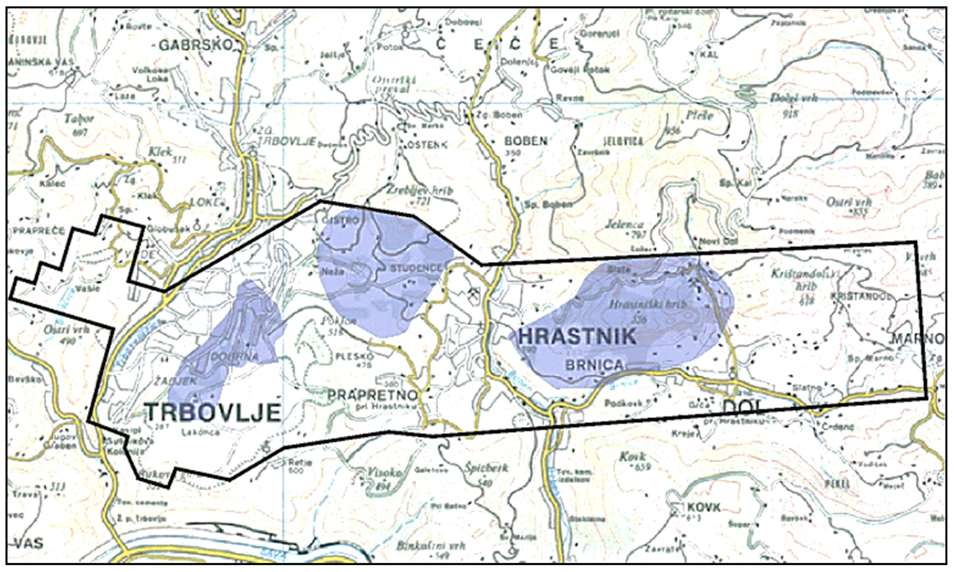
Figure 6 shows the map of Slovenia, on which the area of the Trbovlje–Hrastnik mine is marked with a frame.
2.2. Hydrogeological Characteristics of the RTH Mining Area
Due to the varied geological structure of the coal deposits in the Trbovlje–Hrastnik mine area and the many years of mining with various mining methods, the hydrological events in the rock are varied and sometimes unpredictable. The geological structure is fractured several times by fault zones, which significantly affects the hydrological conditions in the rock of the mine area. From a hydrological point of view, fault zones and an area destroyed by mining indicate water permeability even in areas that would be impermeable in their original state [
10].
In coal mining, collapses accompanied by water ingress occur more frequently in fault zones. Larger pieces of rubble can come into contact with the accumulated mass above the work site and thus pose the danger of water or liquid masses penetrating. Such similar dangerous phenomena usually occur in individual critical excavation areas.
The rocks occurring in the Trbovlje, Ojstro and Hrastnik mining area are divided into good aquifers, conditional insulators and insulators according to their hydrogeological properties. The good aquifers include triad dolomite, which is located at the base of the coal seam. In addition to the dolomite, the Lithuanian limestone, which is located in the overburden and is mainly fed by meteoric water, is also of great importance for the hydrogeological conditions. Due to the ruggedness and cracks in the overburden, the Lithuanian limestone is a strong water reservoir and is categorised as an aquifer.
Conditional insulators are rocks that are insulators in their original state but do not swell on contact with water. They become very permeable to water during demolition. These include overburden marl and Laško marl.
Swell clays are categorised as insulators, provided that the destruction processes are slow. The swelling of the clay closes the cracks created during demolition and the impermeability of the rock is maintained. These are bedrock clays, marine clays from the Oligocene and Sarmatian clays.
2.2.1. Trbovlje Mine
The syncline in the area of the Trbovlje mine is the shallowest. The coal seam is developed to a height of about 170 m above sea level. At the base of the Tertiary, there is Triassic dolomite, which is not layered, strongly fissured and, therefore, permeable to water. It is widely exposed in the Sava Valley, so that the water level in the dolomite has adapted to the bottom of the Sava Valley. The excavation fields in the Trbovlje mine, where the coal was mined, are located higher and are not affected by groundwater.
The water-bearing dolomite of the Trbovlje mine is indirectly drained into the neighbouring Ojstro mine, where the water level is lowered below 50 m above sea level. Water flows into the open underground spaces mainly from the overburden layer and from old workings. The main aquifer in the overburden is Lithuanian limestone. After the coal has been mined, the overburden marl also becomes permeable due to demolition and does not swell enough to close the cracks. The protective layer against the water from the higher overburden is formed by marine clay, which swells so that the cracks in it close quickly. Only in cases where cracks larger than the entire thickness of the Oligocene marine clay form during overburden movements can the protective, water-impermeable layer break and the possible accumulation of water or liquid mass penetrates into the open cave spaces. There is no protective layer of marine clay above the eastern part of the Trbovlje mine, as it was removed before the transgression of the Lithuanian limestone. It is also absent in an average 150 m wide band parallel to the outcrops where the overlying marl reaches the surface. The inflow of water into the Trbovlje mine therefore depends primarily on the amount of precipitation and the consolidation of the overburden and old works, as well as on the shaping of the surface, which is constantly sinking due to demolition process. In recent years, Trbovlje mine has not been excavated, so an intermediate hydrogeological equilibrium has been established in the cave and the water inflows have decreased somewhat and stabilised. In recent times, most of the total water inflow into Trbovlje mine has come from the area of the Sava field. In the area of the Plesko field, the overlying marls and siliceous are eroded, so that the coal is in direct contact with the Lithuanian limestone, which is the most important overlying aquifer in the area of the Trbovlje–Ojstro syncline. The average water inflow from this area in 2007 was around 250 L/min. Due to consolidation, the water inflow from the area of the former Lakonca field and the Frančiška field has decreased and averages 10 L/min.
As of 2018, water flows from the zone of the III field at an average of 35 L/min. Some of the water flows from the surface through the collapsed roof marl into the open underground spaces, at an average of 85 L/min.
In the Trbovlje mine, underground water drains by gravity to the level of the Zvezno Horizon and then into the Sava River. Water pumping is currently only necessary from the Sava field, which is open below the level of the Zvezno horizon. The total inflows of water in the Trbovlje mine in the five-year period are listed in
Table 1.
2.2.2. Ojstro Mine
The hydrogeological conditions in the Ojstro mine are monitored with piezometers, manometers and by measuring the water inflow into the open mine spaces. The Ojstro mine is open to a height of 56 m above sea level (k.+56), where the auxiliary pumping station is located. A total of around 6000 L/min of water currently flows into the mine. Of this, 5600 L/min flows for the most part into the pumping station at k.+56.
The dolomite in the Ojstro mine, i.e., the aquifer, was drained in the past with a line along the dolomite, first at k.+130 (k. means a height mark or horizon measured as altitude), then at k.+120 and even later at k.+90, but currently with drainage facilities and wells at k.+43. All these underground facilities required a large capacity of pumping stations for draining and lowering the water in them. With the long-term withdrawal of water from the mine, the water level dropped intensively. The drainage line at k.+90 has been dry for several years. Based on observations, we note that the water level around the open dolomite structures in the area of the drainage funnel is currently below the k.+55 horizon. In the dolomite, we measure the water level in the Ojstro mine in piezometer PJ-2, where the water level is currently almost 19 m below the line level, i.e., at k.+75.3 and in piezometer PJ-1, where the water level is about 8 m below the top of the well, and at k.+55 and with the help of manometers at the horizontal wells M-3 and M-4. The water from the drainage systems and wells flows into the pumping station at k.+43, the deepest open point of the Ojstro mine. The wells drilled from the pumping station itself in the direction of Terezija polje supply most of the water. Currently, around 2730 L of water per minute flows from the wells. The wells are equipped with shut-off valves so that they can be temporarily closed. In addition to these wells, many shorter wells have been made in the area of the dolomite aquifer, but these are not as extensive. The total inflow of water into the Ojstro mine over the five-year period is shown in
Table 2.
2.2.3. Hrastnik Mine
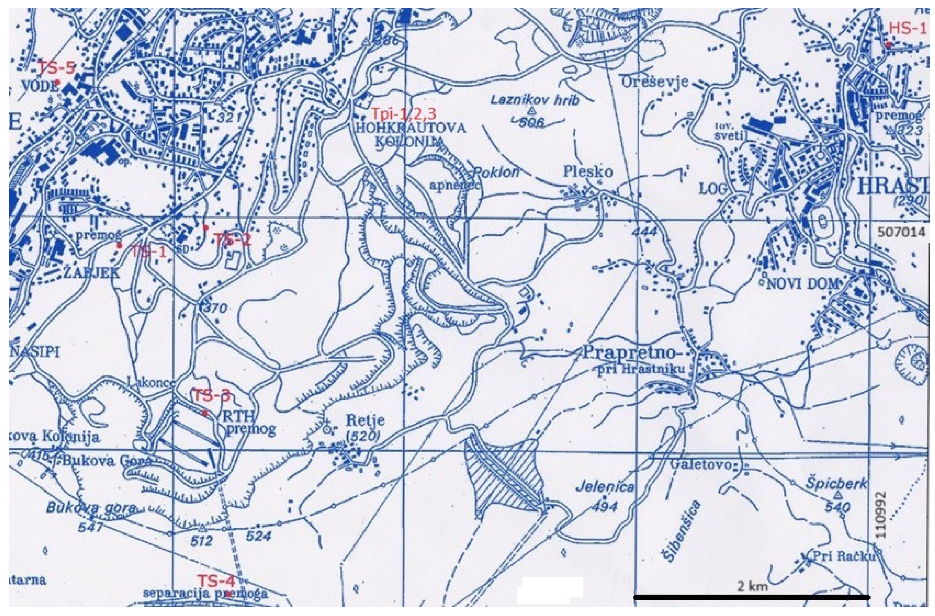
In 2021, the Hrastnik mine was in the final phase of closure work; the closure of the RTH pits proceeds from east to west, i.e., from the mostly still closed Dol pits to the main pits of the Trbovlje mine, where coal was mined the longest. The Hrastnik 1 shaft was filled up to level IV horizons. The production of plugs and the decommissioning of the main pumping station II in the Hrastnik mine also led to a rise in the water level in the dolomite. After the abandonment of pumping station II at k.+80, audit GT-1 was filled with water up to k.+200, where an auxiliary pumping station was built. A deep piezometer PH-1b/04 is provided to monitor the water level in the dolomite. The water inflows into the Hrastnik mine over a period of five years are shown in
Table 3.
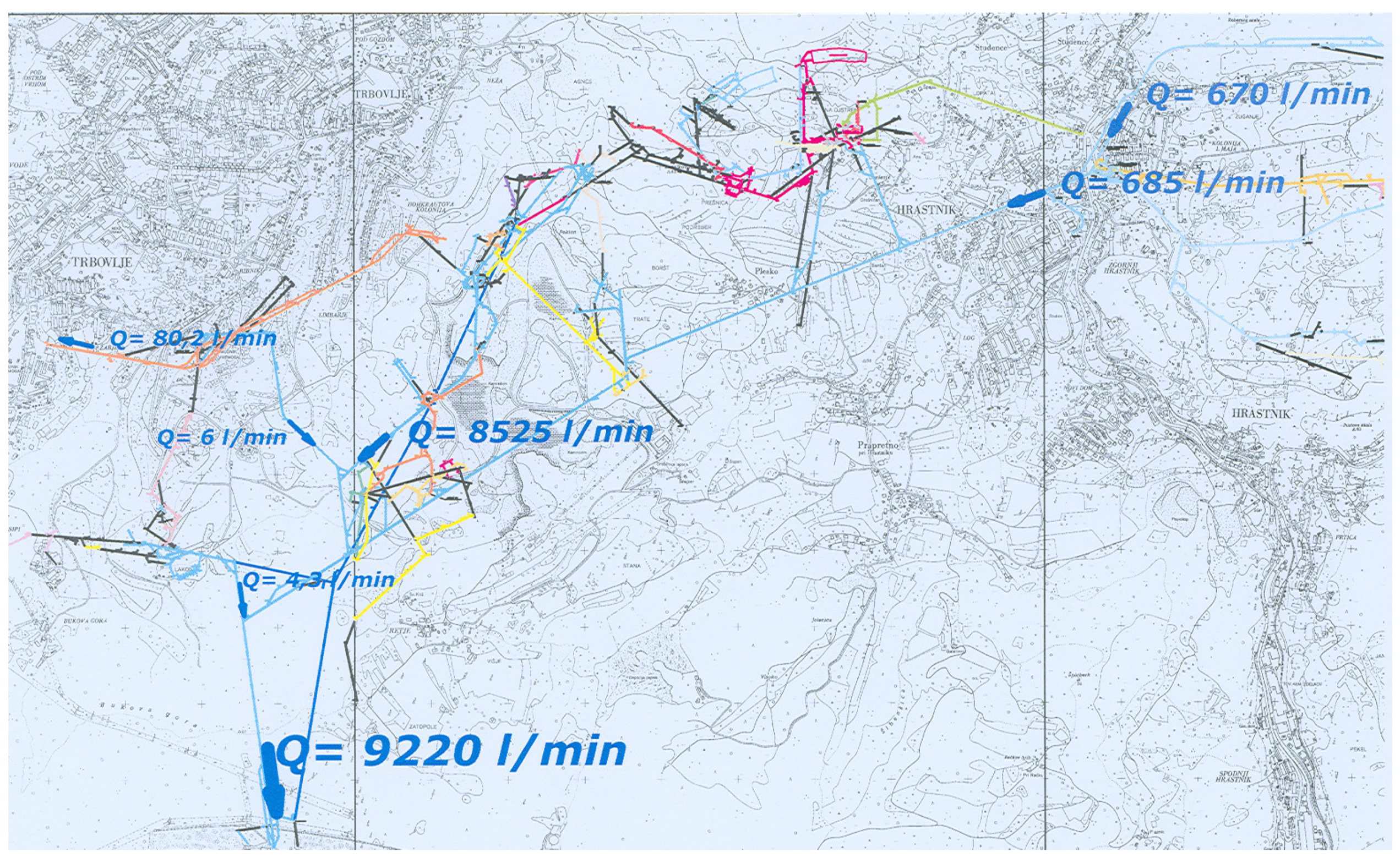
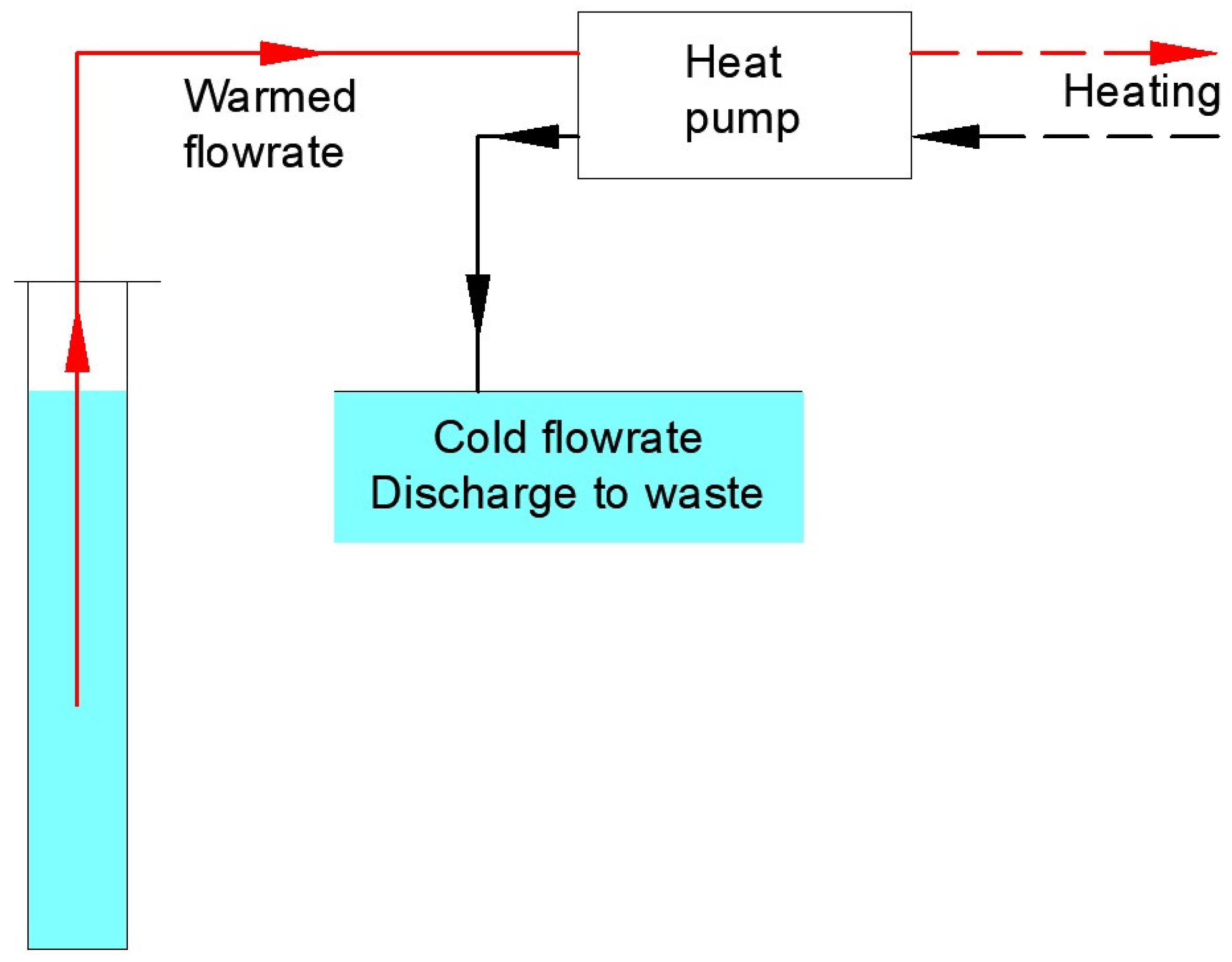
This means that the total amount of water in the area of the closed RTH coal mine reaches a flow rate of around Q = 9000 L/min or 0.15 m3/s. The average water temperature in winter is 11 °C.
The collection of groundwater and the total amount of water flowing from the Trbovlje–Hrastnik mine are shown in
Figure 7.
The results of the chemical analysis show that none of the analysed parameters exceed the limit values specified in the Slovenian regulations on the health suitability of drinking water (
Table 4). An exception is the iron (Fe) content in the sample from the drainage channel, where the normative value is exceeded. The reason for the exceeding of the iron content is probably due to the rather limonitised rock or the large amount of milling fraction in the water in the drilled limonitised fault zone. The chemical analyses of the water were carried out by an authorised laboratory and the RTH laboratory. Basically, we are dealing with drinking water that does not contain any chemical compounds or will not negatively affect the sustainability of mine water utilisation. In the case of limescale deposits in water installations, a maintenance programme to remove limescale must be prescribed depending on the occurrence of deposits in order to maintain the efficiency of the heating system. Relatively simple removal of limescale deposits is possible with diluted hydrochloric acid (HCl).
