Article

Predictability of Hurricane Storm Surge: An Ensemble Forecasting Approach Using Global Atmospheric Model Data

by
Rebecca E. Morss
1,*,
David Ahijevych
1,
Kathryn R. Fossell
1,
Alex M. Kowaleski
2 and
Christopher A. Davis
1
1
NSF National Center for Atmospheric Research, Boulder, CO 80027, USA
2
Cooperative Institute for Research in the Atmosphere, Fort Collins, CO 80521, USA
*
Author to whom correspondence should be addressed.
Water 2024, 16(11), 1523; https://doi.org/10.3390/w16111523
Submission received: 11 April 2024 / Revised: 7 May 2024 / Accepted: 16 May 2024 / Published: 25 May 2024
(This article belongs to the Special Issue Simulation and Numerical Analysis of Storm Surges)

Abstract

:
Providing storm surge risk information at multi-day lead times is critical for hurricane evacuation decisions, but predictability of storm surge inundation at these lead times is limited. This study develops a method to parameterize and adjust tropical cyclones derived from global atmospheric model data, for use in storm surge research and prediction. We implement the method to generate storm tide (surge + tide) ensemble forecasts for Hurricane Michael (2018) at five initialization times, using archived operational ECMWF ensemble forecasts and the dynamical storm surge model ADCIRC. The results elucidate the potential for extending hurricane storm surge prediction to several-day lead times, along with the challenges of predicting the details of storm surge inundation even 18 h before landfall. They also indicate that accurately predicting Hurricane Michael’s rapid intensification was not needed to predict the storm surge risk. In addition, the analysis illustrates how this approach can help identify situationally and physically realistic scenarios that pose greater storm surge risk. From a practical perspective, the study suggests potential approaches for improving real-time probabilistic storm surge prediction. The method can also be useful for other applications of atmospheric model data in storm surge research, forecasting, and risk analysis, across weather and climate time scales.

1. Introduction

Storm surges generated by tropical cyclones (TCs) are major threats to lives and property worldwide—including in the U.S., as Hurricane Ian recently demonstrated. Motivated in part by devastating TC storm surge impacts in the 2000s [1,2], the research community and U.S. National Weather Service (NWS) have advanced multiple aspects of storm surge prediction and risk communication over the last two decades [3,4,5,6,7,8,9]. However, for many U.S. coastal hurricane evacuation decisions, storm surge inundation forecasts are needed at longer lead times than they are currently available [10,11,12,13,14]. As sea levels rise due to climate change and coastal populations increase, the importance of storm surge forecast information at several-day lead times is likely to continue growing.
TC-induced storm surge inundation is challenging to forecast for several reasons, including the dependence of location-specific water levels on details of a TC’s track, intensity, and structure [3,6,15,16,17,18,19]. Thus, although many storm surge studies focus on the accuracy of deterministic (single-valued) simulations and predictions, the NWS National Hurricane Center (NHC) and some other prediction centers forecast storm surge using an ensemble approach [20]. For example, NHC’s operational storm surge prediction system generates probabilistic forecasts using a computationally efficient storm surge model, SLOSH (Sea Lakes and Overland Surges from Hurricanes), which enables running many simulations. SLOSH is forced with parameterized vortices defined by TC track, intensity, radius of maximum wind, and other parameters, and storm surge ensembles are generated by systematically perturbing TC parameters and rerunning SLOSH for each perturbed TC [3,6,21].
This study uses an ensemble storm surge modeling approach to investigate the predictability of TC-induced storm surge at multiple forecast lead times. More specifically, we examine predictability of coastal inundation due to storm-induced surge combined with tides. Although the technical terminology for this combined hazard is “storm tide”, we follow NHC and many others by referring to this as “storm surge” or “surge”. This is consistent with the study’s focus on predictability: since tides are highly predictable, the hazard’s limited predictability arises primarily from the storm-induced surge. The study does not include other factors that can contribute to storm-induced water levels, such as waves and precipitation runoff, but the approach could readily be adapted to use techniques for coastal water level simulation that incorporate those factors.
Storm surge ensemble approaches that start with a control simulation and independently perturb TC parameters, similar to NHC’s current method, have proven useful for both research and real-time prediction [3,17,21,22,23,24,25,26,27]. However, the resulting storm surge ensembles do not reflect the integrated, multi-parameter atmospheric uncertainty associated with a particular TC. Another approach to generating storm surge ensembles is using gridded output from an atmospheric numerical model ensemble to force a set of storm surge model simulations. Global atmospheric model simulations from forecast centers can be used for this type of work, but they may lack the spatial resolution, or other features required to adequately simulate storm surge magnitude, especially for strong or small TCs [28,29,30,31]. Consequently, this type of work often uses a higher-resolution, regional atmospheric model ensemble as the meteorological forcing [15,16,32,33,34]. Such simulations are usually run retrospectively rather than in real time due to the logistics and computational expense involved.
Here, we employ an intermediate approach that derives TC tracks and other parameters from a global numerical weather prediction ensemble, and then uses the resulting ensemble of parameterized TCs to force a dynamical storm surge model. This approach allows us to utilize operational weather prediction ensemble data, which are readily available for a variety of TCs at a range of lead times, to generate ensembles of parameterized TC forecasts that are consistent with realistic, storm-specific atmospheric scenarios. Using parameterized TCs also facilitates adjusting the ensemble for biases in the atmospheric model data. We use global weather prediction model data because doing so enables extending the research to longer forecast lead times. Although specifying TCs with a small number of parameters alters details of the storm structure, parameterized TCs are frequently used in storm surge simulation and prediction [18,23,26,35,36,37], and this method is appropriate for our ensemble approach and study goals. Further, parameterizing TCs from available atmospheric model data is more computationally efficient than running an ensemble of high-resolution atmospheric simulations, and thus more practical to implement in real time or for a range of cases.
The article focuses on Hurricane Michael, which initially formed as a tropical depression in the Gulf of Mexico at approximately 6 UTC 7 October 2018, and then rapidly organized and intensified. The storm made landfall in the Florida panhandle 3.5 days later as a Category 5 hurricane (Figure 1), causing extensive damage from both wind and storm surge [38]. Hurricane Michael presents an interesting case for storm surge prediction for several reasons, including its rapid intensification, the associated challenges of accurately forecasting its intensity evolution, and its formation only a few days prior to landfall [38,39,40,41,42]. Although the article examines one TC, the type of atmospheric forcing data used is readily available, and so the methods can be extended to investigate other storms.
The research has three goals:
  • Develop and test a method for parameterizing tropical cyclones from atmospheric model simulations for use in storm surge simulation, prediction, and research.
  • Use the method, in conjunction with numerical weather prediction ensemble data and a dynamical storm surge model, to generate ensemble TC–storm surge predictions for Hurricane Michael.
  • Analyze the resulting ensemble data to:
    • investigate the predictability of storm surge inundation across a range of forecast lead times, from approximately 1–3 days, and
    • explore the importance of different TC parameters for predicting storm surge inundation at different lead times.
The method in #1, combined with the approach in #2, enables us to generate storm surge ensembles that simulate uncertainties in inundation associated with the TC forecast uncertainties represented in atmospheric ensembles. Here we use the methods for storm surge predictability research, but they are also applicable for other types of work, including practical storm surge prediction and longer-term storm surge risk analyses using climate or weather model data.
We use atmospheric data from the ECMWF (European Centre for Medium-Range Weather Forecasts) Ensemble Prediction System [43] and the dynamical storm surge model ADCIRC (ADvanced CIRCulation Model; [44]). However, a similar approach can be implemented with other types of atmospheric model data and storm surge forecasting platforms. This includes other dynamical storm surge hazard models, as well as potentially machine learning or surrogate model techniques for storm surge prediction [7,27,45,46]. The study also illustrates an approach for adjusting the evolution of TCs in atmospheric model simulations for biases, enabling improved representation of TC and storm surge forecast uncertainties. Here, we adjust storm intensities, but the approach could be adapted to adjust other aspects of TC forecasts, such as storm track or forward speed.
To analyze storm surge predictability at multiple forecast lead times, we generated TC–storm surge ensemble forecasts at five initialization times, every 12 h from 0 UTC 8 October to 0 UTC 10 October 2018 (Table 1, Figure 2). We also ran a storm surge simulation forced by NHC’s Best track data for Hurricane Michael, which is used to evaluate the ensemble forecasts, and a set of experiments with perturbed Best track parameters to illustrate aspects of the study methods (Figure 2). We compare the Best track surge simulation with observations to validate that it is reasonable, but our primary goal is not to develop skillful deterministic storm surge predictions. Instead, we aim to investigate storm surge predictability, while also developing a method that can be applied for a variety of TCs. As a step towards improving storm surge predictions, however, we designed the method to use data that are available for real-time forecasting.
Although the analysis presented focuses on geophysical aspects of TC storm surge, it is informed by the growing body of work on TC hazard communication and decision making [13,47,48,49,50,51,52,53,54,55]. For example, when investigating the predictability of storm surge, we use metrics related to inundation in locations that are normally dry (above mean high tide) because that is the type of information needed for many protective decisions. We also examine inundation timing, since this is important for decision making. Because many decisions rely on location-specific inundation, we investigate the ensembles’ potential to identify locations at greater or lesser storm surge risk. However, given the major challenges of predicting location-specific storm surge at longer lead times, we also explore the use of spatially integrated inundation measures, as a step towards developing metrics that may facilitate providing the longer lead time information needed for decision making given limited predictability [17].
Section 2 describes the study methods and data, including the design and implementation of the TC–storm surge ensemble forecasts that are the focus of the study. This section also describes the Best track storm surge simulation, the Best track experiments, and the metrics used for data analysis. Section 3 presents results from the Best track simulation and experiments, and Section 4 presents results from the TC–storm surge ensemble forecasts. The article closes with a summary and discussion.

2. Materials and Methods

The methods for this study and associated storm surge simulations are summarized in Figure 2. The simulations were run using ADCIRC (v55.02), an open source, shallow water model that incorporates tidal and atmospheric forces [56,57]. All simulations used parameterized TCs generated using the Generalized Asymmetric Holland Model (GAHM; [18]) in ADCIRC (v55.02, option NWS = 20) as the meteorological forcing. Each parameterized TC is defined by its position (latitude and longitude), maximum sustained surface winds (Vmax), minimum sea-level pressure (Pmin), and wind radii representing the maximum extent of sustained 34, 50, and 64 kt winds (R34, R50, and R64, respectively) in 4 quadrants (northeast, southeast, southwest, northwest). Within ADCIRC, the GAHM is used to transform sequences of TC parameters into asymmetric vortex wind and pressure fields, which are then used as atmospheric forcing in ADCIRC’s ocean circulation model. We selected the GAHM because it allows a TC vortex to be fitted to multiple wind radii in each quadrant, which generates more realistic parametric vortices than a symmetric vortex model.
We used parameterized storms because, as discussed in Section 2.1, this enables us to use the ECMWF ensemble forecast data archived at 6 h intervals, and it facilitates adjusting the TC intensity bias in the ECMWF ensemble. Parameterizing a TC simplifies its wind field, which can affect storm surge simulation results; however, this study focuses on ensemble forecasts, rather than the accuracy of individual storm surge simulations. Although ADCIRC includes the capability to simulate waves, e.g., with the SWAN (Simulating WAves Nearshore) model [58], we did not include waves in our study to simplify the methodology for demonstration.
The study used three types of meteorological data: NHC’s Best track for Hurricane Michael, NHC’s official forecasts for the storm (OFCL), and forecast data from the 50-member operational ECMWF ensemble. Best track data represent the actual evolution of a TC in terms of the parameters described above, based on post-storm analysis conducted by NHC [59]. OFCL and ECMWF represent different types of forecast information available as Hurricane Michael approached the U.S. coast; OFCL data are in the form of parameterized TCs similar to Best track, and the ECMWF data used are in the form of spatially gridded meteorological fields. As described in subsequent sections, we ran ADCIRC simulations using two types of meteorological forcing: (1) variations of Best track and (2) parameterized TCs derived from the ECMWF ensemble forecasts, with intensity scaled using OFCL. While (1) must be run retrospectively, (2) requires only data available in near-real time. We also explored using OFCL as the meteorological forcing, but as discussed further in Section 3.2, some of these simulations produced parameterized TC vortices that evolved unrealistically due to the longer (12 or 24 h) forecast intervals in the OFCL data; thus, these simulations are not used in this article.
Implementing the study’s methods involved reconciling the different averaging periods used in wind speed data. The Vmax values in Best track and OFCL represent 1 min average wind speeds (V1), but ADCIRC’s dynamic core is calibrated for 10 min average winds (V10). To convert V1 to V10, the ADCIRC code multiplies parameterized TC Vmax input by a factor one2ten = 0.8928 [58,60]. The gridded ECMWF wind fields, on the other hand, represent V10 [61]. For the ADCIRC meteorological forcing, we kept all ECMWF ensemble wind speeds in terms of V10, as described below. However, to compare Vmax across different types of meteorological data in the figures and tables, we divided ECMWF Vmax10 by one2ten to convert to Vmax1, since that is how Best track and OFCL wind speeds are typically depicted.
The standard format for the parameterized TCs used here represents distance in units of nautical miles (nmi) and wind speed in knots (kt), with 1 nmi = ~1.15 miles = ~1.85 km and 1 kt = 1 nmi∙h−1 = ~0.51 m∙s−1. Because TC wind radii are typically defined using wind speeds in units of kts, we use nmi and kt in much of the text.

2.1. ECMWF-Derived Parameterized TC Ensemble Forecasts

The operational ECMWF ensemble uses a global numerical weather prediction model to forecast a range of possible future states given initial condition and model uncertainties [62]. We obtained ECMWF data from the TIGGE archive [63,64] at five initialization times: 0 UTC and 12 UTC 8 October 2018, 0 UTC and 12 UTC 9 October 2018, and 0 UTC 10 October 2018, with forecast output at 6 h intervals. The ensemble members were run with an effective grid spacing of ~18 km and were downloaded on a 0.125° latitude × 0.125° longitude grid. The first initialization time is less than 12 h after Michael became a tropical storm, and the last initialization time is approximately 18 h before Michael’s landfall (Table 1).
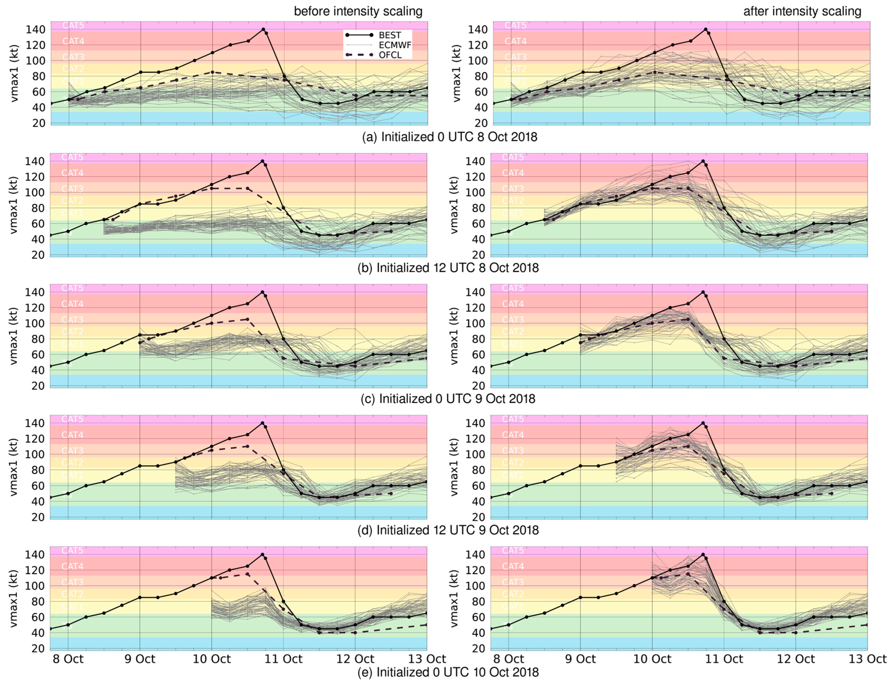
Although the ECMWF ensemble data provide a useful representation of the meteorological forecast uncertainty associated with Hurricane Michael, they have two limitations for simulating TC-induced storm surge using ADCIRC. First, when the gridded ECMWF data are used to force ADCIRC, the model’s wind and pressure interpolation algorithm does not smoothly translate the storm as a coherent structure between the 6 h meteorological updates. Instead, the storm fades out at the initial location and in at the new location, which induces inaccuracies in the storm surge simulation. Second, at all five initialization times examined here, all of the ECMWF ensemble members forecast TCs with substantially lower peak Vmax than both OFCL and Best track (Table 1, left hand side of Figure 3). This intensity bias occurs for several reasons, including (1) with ~18 km grid spacing, the atmospheric model cannot resolve the hurricane’s inner core and (2) with the surface layer parameterizations used by ECMWF in 2018, the model predicted 10 m wind speeds that were too low in hurricanes [41,65,66,67,68].
To address these limitations, we developed a method for parameterizing the ECMWF ensemble members’ TCs (Section 2.1.1), and then adjusting the TCs’ Vmax using OFCL (Section 2.1.2). NHC issues updated OFCL forecasts at 3, 9, 15, and 21 UTC, and the operational ECMWF ensemble is available several hours after its initialization time. Thus, to correspond to each ECWMF initialization time, we chose the OFCL issued 3 h later. After scaling each parameterized TC’s Vmax, we adjusted its Pmin to reflect the new Vmax (Section 2.1.2) and then estimated missing wind radii (Section 2.1.3).
Although the TCs in OFCL reach higher intensities than those in the ECMWF ensemble, OFCL still substantially underpredicts Hurricane Michael’s peak Vmax, especially at longer lead times (Table 1). OFCL also only provides forecast data every 12 or 24 h (Figure 3), which limits the temporal resolution of the intensity scaling. However, rather than scaling TC intensity using Best track or another source, we used OFCL to simulate forecast information available at the time each ECMWF ensemble forecast was available.

2.1.1. Parameterizing ECMWF Ensemble Members

To derive TC parameters for each ECMWF ensemble member and forecast time, we first obtained TC center locations from the ECMWF A-deck files. We then used the gridded ECMWF data to identify the maximum 10 m wind speed within 250 km of each TC center (Vmax) and minimum sea level pressure within 100 km (Pmin). We also calculated the maximum distance of 34 kt, 50 kt, and 64 kt winds within 300 nmi (555.6 km) of each TC center (R34, R50, and R64) in each of the four quadrants. This process generated, for each initialization time and ensemble member, a sequence of parameterized TCs at 6 h intervals that represents the storm’s evolution in the ECMWF forecast data.

2.1.2. Adjusting TC Intensity

To adjust TC intensity for each initialization time, we first scaled the evolution of mean Vmax10 in the parameterized TC ensemble using the evolution of Vmax10 in the corresponding OFCL, as described in further detail in Appendix A. We then estimated the Pmin of each parameterized TC in the ensemble based on its new Vmax, using the wind-pressure relationship in [69] as described in Appendix B. Together, these two steps generate ensembles of parameterized TC forecasts whose tracks match the TC tracks in the ECMWF ensemble members, but with reduced intensity bias.
Note that this is only a first-order approach to adjusting forecast TC intensity in atmospheric model output, which could be improved upon in future work. Compared to approaches that adjust TC intensity and structure by blending parameterized vortices with atmospheric model data [5,66], using only parameterized vortices limits our ability to represent winds away from the TC core, but it facilitates using a variety of types of already-available atmospheric model data.

2.1.3. Estimating Missing Wind Radii

For some TCs, the intensity adjustment described in Section 2.1.2 increased Vmax from below 34, 50, or 64 kts to above those thresholds. When this occurs, R34, R50, and/or R64 values are missing for that ensemble member and forecast time. Preliminary simulations indicated that, as illustrated in Section 3.2, missing wind radii can substantially affect a parameterized TC’s structure and the storm surge it generates in ADCIRC. To address this, we developed and implemented a method for filling in missing wind radii in the intensity-adjusted TCs, using available wind radii for that TC ensemble member and information derived from the wind radii in the corresponding OFCL forecast. Details of this method are presented in Appendix C.
We developed this method iteratively, by testing it for a variety of ensemble members, examining the resulting ADCIRC simulations, and then making adjustments to address cases of unrealistic TC wind fields or storm surge. Like the TC intensity adjustment method, this approach could be improved upon in future work. However, the method is simple, implementable in real time, and, as shown in Section 3.2, effective for the purpose of this study.

2.2. Storm Surge and Coastal Inundation Simulations

To simulate storm surge and coastal inundation, we ran with ADCIRC in two-dimensional mode, using the same setup as [16,17] with an updated version of the ADCIRC code. ADCIRC uses a finite-element, variable resolution mesh; here, we use a mesh developed and validated by Riverside Technology and AECOM with the National Ocean Service [70,71]. This mesh was developed for operational use by NOAA and has been used in a number of research studies (e.g., [16,17,19,27,72,73]). It contains approximately 1.8 million nodes spanning the Gulf of Mexico and U.S. Atlantic coast and inland to 10 m elevation. The node spacing is coarse in the open ocean and decreases to less than 200 m near the coast (Figure 4), which enables it to represent complex coastal shorelines, bathymetry, and topography at that resolution.
Simulations were initiated with a cold start run beginning at 0 UTC 22 September 2018, without meteorological forcing. Astronomical tides were ramped up to full force over six days, and then the cold start run was continued for another nine days to allow the basin to come into tidal equilibrium without transient gravity waves. Conditions were output from the cold start run at 0 UTC 7 October 2018 and used to initiate the Best track simulations, and subsequently the ensemble forecasts, as described below. Tidal forcing is continued throughout all of the simulations.

2.2.1. Best Track Simulation and Best Track Experiments

To generate an estimated “truth” simulation, we used ADCIRC to simulate the storm surge and coastal inundation associated with Hurricane Michael’s Best track. As shown in Figure 3, Michael’s Best track includes data at 6 h intervals, with one additional data point around the time of peak intensity. To run the Best track simulation, we used output from the cold start run to hot-start ADCIRC at 0 UTC 7 October with Best track forcing added and ramped up to full strength over 1 day (using a hyperbolic tangent ramp function).
We also present results from four Best track experiments, two that systematically investigate the effects of missing wind radii and two that test the method used to estimate missing wind radii. These experiments used the same evolution of TC position, Vmax, and Pmin as the control Best track simulation (BT_control), but with modified wind radii:
  • BT_removeR64: R64 (64 kt wind radii) values removed in all 4 quadrants
  • BT_removeR64R50: R64 and R50 (64 kt and 50 kt wind radii) values removed in all 4 quadrants
  • BT_replaceR64: R64 removed in all 4 quadrants, then estimated as described in Section 2.1.3
  • BT_replaceR64R50: R64 and R50 removed in all 4 quadrants, then estimated as described in Section 2.1.3
The first two experiments leave some wind radii unconstrained, so that the GAHM fits a vortex with the available wind radii. For the latter two experiments, we estimated wind radii using R64:R50 and R50:R34 ratios calculated using Best track rather than OFCL. ADCIRC simulations for these experiments were run in the same way as for Best track, with TC wind radii modified throughout the simulation.

2.2.2. TC–Storm Surge Ensemble Forecasts

For the TC–storm surge ensemble simulations, we output conditions from the Best track simulation at the ensemble initialization time, and then hot-started ADCIRC runs forced by the sequence of parameterized TCs in each of the intensity-adjusted TC ensemble members. This generates, for each initialization time, a 50-member ensemble of TC–storm surge forecasts. For the 8 and 9 October initializations, TC forcing was ramped up to full strength over 1 day. For the 10 October initialization, we used a 0.5 day ramp so that the TCs reached full intensity prior to landfall.
We hot-started the ensemble forecasts from the Best track simulation to account for the cumulative effects of the storm up to the initialization time. We also tested an alternate approach for generating storm surge ensembles, by initializing ADCIRC at 0 UTC 7 October with output from the cold start run and prepending Best track on each TC ensemble member. The two approaches generated similar storm surge ensembles, indicating that a hot-start approach with a 1.0 or 0.5 day ramp worked well, at least for Hurricane Michael and the forecast lead times studied here. Thus, we used the hot-start approach to increase computational efficiency.
As described in Section 2.1, all wind speeds (Vmax and wind radii) in the parameterized TC ensemble forecasts represent V10. Thus, the TC–storm surge ensemble forecasts were run with a version of ADCIRC recompiled after setting one2ten to 1.0 in the Fortran code, to remove the conversion from V1 to V10 that ADCIRC typically uses with parameterized TC input [60].

2.3. Data Analysis

To validate that the simulation methodology produces realistic results, we compared storm surge output from the Best track simulation with observations taken during Hurricane Michael in the primary area of interest. Based on [38], we selected the 17 USGS water level sensors (https://stn.wim.usgs.gov/FEV/#2018Michael, accessed on 14 November 2023; [74]) shown in Figure 4 and Table 2. We matched each observation location with the closest wet ADCIRC node (given the mesh spacing of ~200 m near the coast), converted the observation data from feet to meters, and then compared simulated and observed maximum water levels.
To compare the Best track experiments with the control Best track simulation, we examined their parameterized TC wind fields, spatial distribution of the storm surge, and time series of inundation volume. We use inundation volume as a spatially integrated summary measure of coastal inundation; following [17], we calculated inundation volume at a given time by identifying each ADCIRC node that is normally dry (above Mean High High Water, MHHW) and has inundation depth ≥ 1 m, and then summing the inundation volume (inundation depth × cell area) of those nodes. We examine results for inundation ≥ 1 m because this corresponds to the inundation threshold used by the National Hurricane Center (3 feet = 0.91 m) for issuing storm surge watches and warnings, although as described below, we also used other inundation thresholds. To filter out inundation in outlying areas unrelated to TC-induced surge, we calculated inundation volume over a regional domain (92–82° W, 26–31.5° N), excluding the leftmost 2.5% and rightmost 2.5% of nodes in the inundation area [17].
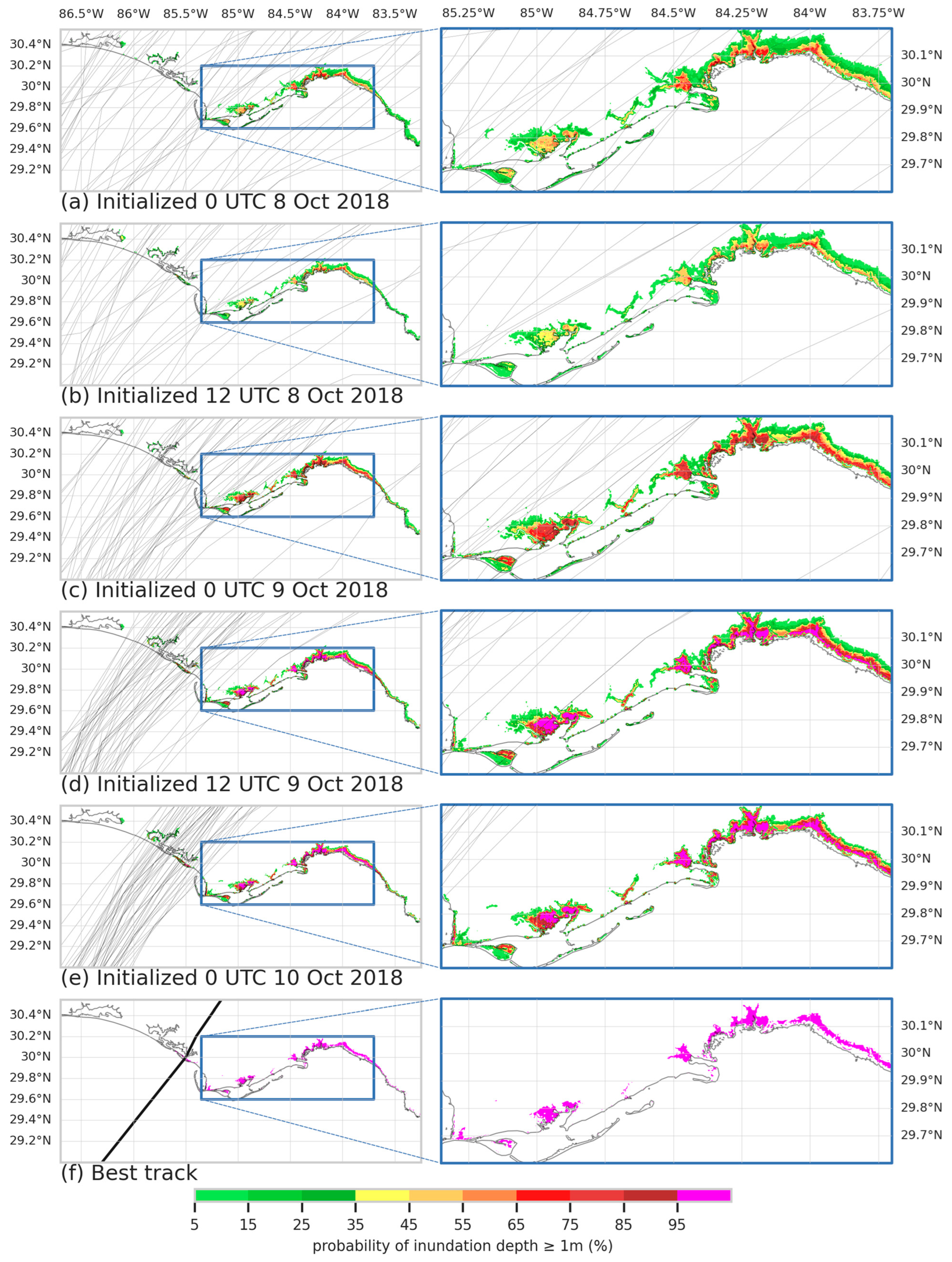
To analyze results from the storm surge ensemble forecasts, we used the control Best track simulation as “truth” to enable comparison across all ADCIRC nodes. Results are shown for three metrics: (1) maps of probability of inundation depth ≥ 1 m (above ground), for ADCIRC nodes above MHHW [16], (2) time series of inundation volume (calculated as described above), and (3) Brier skill score (BSS) [75]. We use the first metric to compare the spatial distribution of predicted coastal inundation at the different initialization times with each other and with the Best track simulation. The second metric serves as a summary measure for exploring how inundation magnitude and timing vary across the 50 ensemble members and how this changes with forecast lead time. We also use this spatially integrated metric to assess large-scale differences in inundation severity across the ensemble and compare the range of ensemble scenarios with Hurricane Michael’s actual inundation. The third metric, BSS, assesses ensemble forecast skill at each initialization time by comparing the predicted probability of inundation greater than or equal to a given threshold (1 m or 0.3 m) to the Best track simulation. BSS was calculated for nodes at or above MHHW within the same domain as the inundation volume (92–82° W, 26–31.5° N). The fraction of nodes within that domain with inundation greater than or equal to that threshold in the Best track simulation was used as the reference forecast. A higher BSS indicates a more skillful forecast, with a maximum of 1.0 for a perfect forecast.
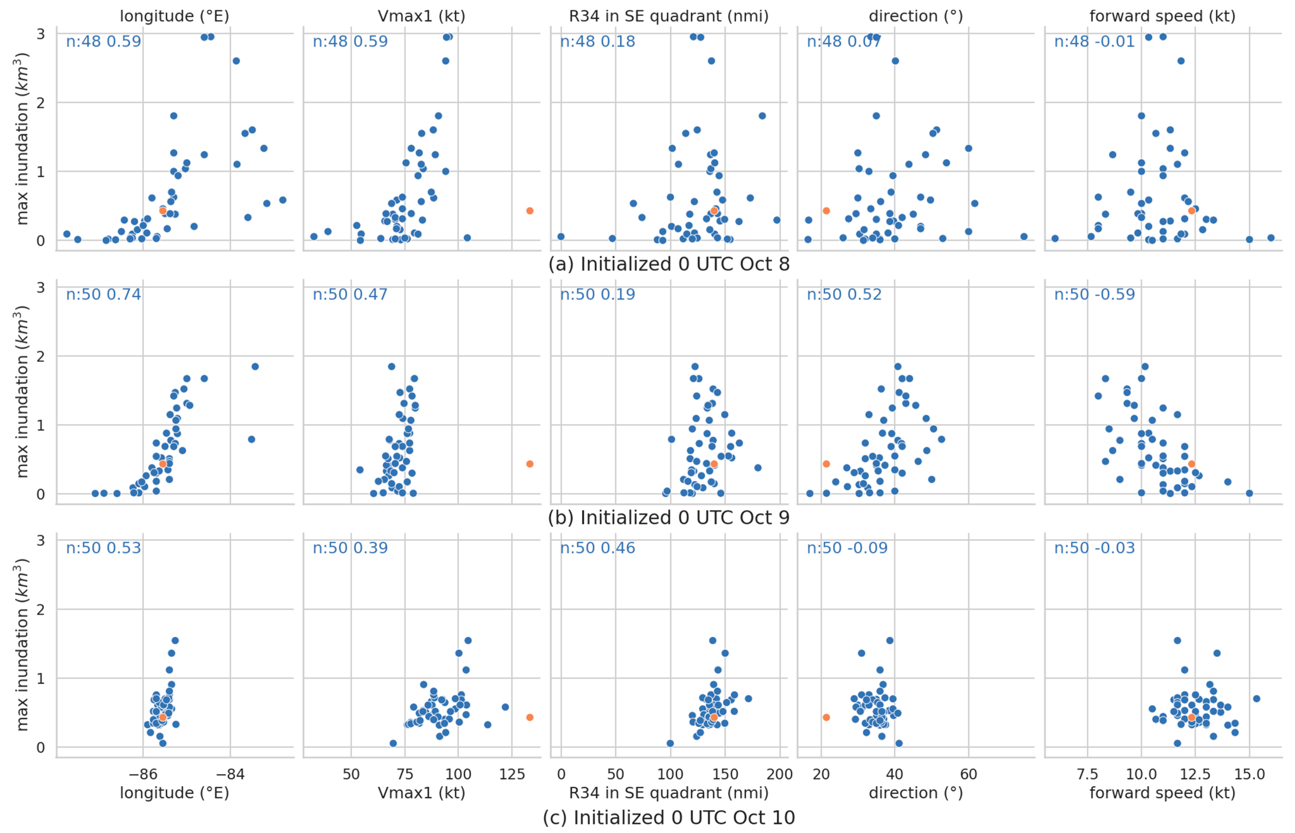
The final set of results analyzes relationships between an ensemble member’s TC parameters and its simulated maximum inundation volume, for the three 0 UTC initialization times. Results are presented for five TC parameters that prior research has found influence storm surge: longitude (representing landfall location), direction (angle), Vmax (intensity), R34 in the TC’s SE quadrant (storm size), and forward speed [17,19,23,24,25,76,77,78,79]. Direction is measured clockwise relative to north = 0°. We used R34 as a measure of storm size because many of the ensemble TCs lacked R50 and R64 values, and we used size in the SE quadrant because for Hurricane Michael it contains most of the onshore winds that are responsible for much of the storm surge [80]. Relationships were examined for each TC parameter at landfall and 6 h before and after landfall [76,77,81].

3. Results: Best Track Simulations

3.1. Best Track Simulation and Comparison with Observations

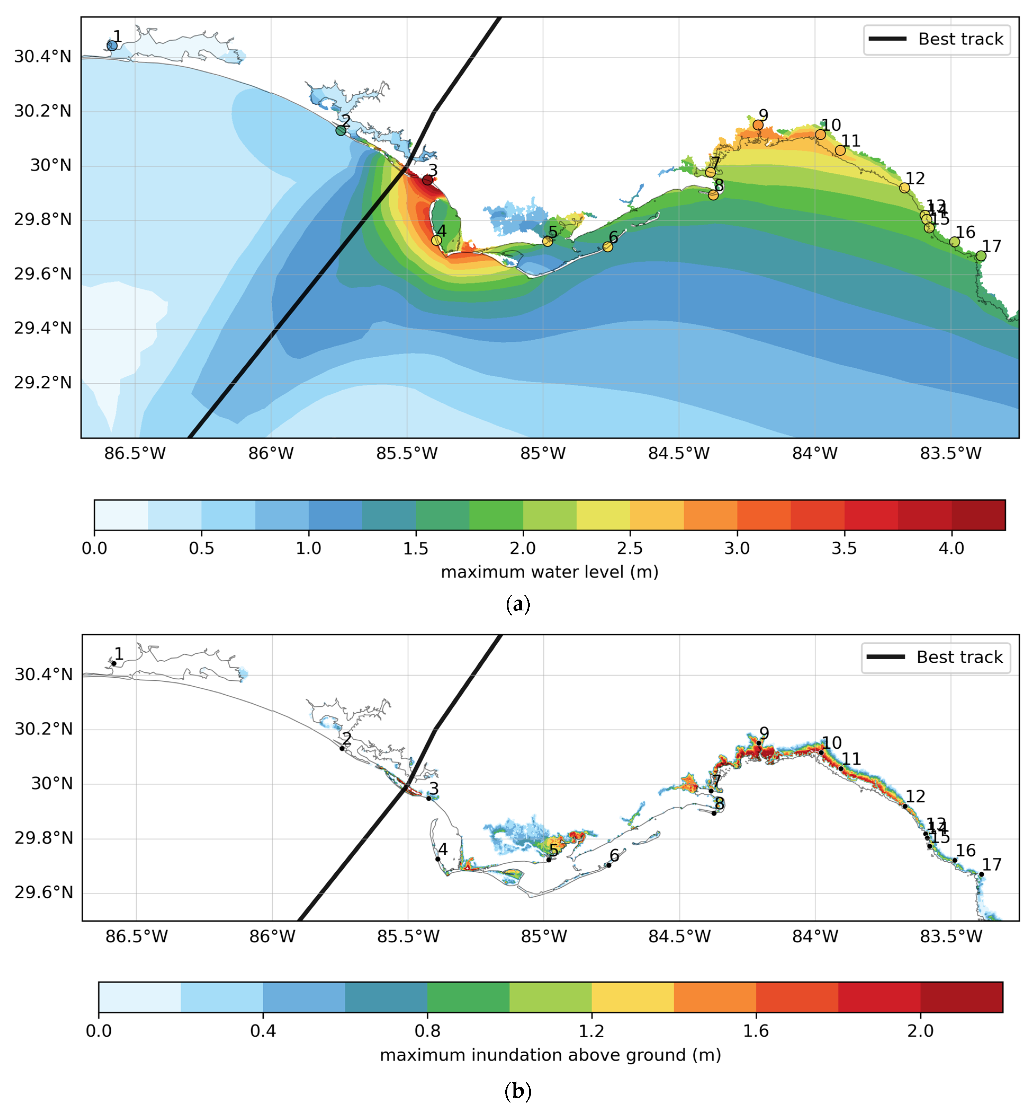
Figure 5 depicts results from the Best track ADCIRC simulation. The general spatial patterns of simulated storm surge are similar to observations and previous studies of Hurricane Michael, with the highest water levels just to the east of the storm’s track, an extended area of elevated water levels further east along the Florida coast, and a much smaller increase in water levels west of the track [5,30,38,39,82]. The extended area of elevated water levels to the east occurs in the Big Bend region of Florida, where the coastline transitions from approximately east–west along the Florida Panhandle to a more north–south orientation along the Florida Peninsula. This region is highly susceptible to storm surge due to its concave coastline combined with shallow bathymetry along the Florida shelf [83].
Figure 5a and Figure 6 compare maximum water level in the Best track simulation with observations. The correlation (R2 = 0.79) is on the high end of other published simulations of Hurricane Michael’s storm surge (range of R2 = 0.16–0.74), and the root-mean-square error (RMSE = 0.6 m) is within the range of previous studies (0.26–0.63 m; [5,30,39,82]). The simulated maximum water level at Mexico Beach (location 3), the station with the highest observed water level, is within 10% of the observed value. The observation stations with the largest errors (locations 1–2, 4–6, and 8) were all located on or behind a narrow peninsula or barrier island, where the ADCIRC node spacing may be insufficient to simulate the details of storm surge. Illustrating the importance of such details for accurately simulating water levels at specific locations, if observation location 4 is shifted less than 0.002° (several hundred meters) to the east, the closest ADCIRC node shifts from the ocean side to the bay side of St Joseph peninsula. Because the simulated maximum water level on the ocean side of the peninsula is more than 1 m higher than on the bay side (Figure 5a), this small shift changes the overprediction in Figure 6 to an underprediction. Further east (locations 9–17), simulated maximum water levels have smaller errors.
Figure 6 also indicates that simulated maximum water levels are lower than those observed at most of the gauge locations. One possible explanation is that the simulation does not include wave heights, which [84] indicates were 0.5 m or greater for Michael at several of the observation locations examined here. Another is that the atmospheric forcing used here only includes the simulated TC wind fields, not the large-scale easterly flow that observation time series indicate increased water levels prior to the storm’s arrival. Supporting this latter explanation, ref. [5] found that simulating Hurricane Michael’s storm surge with larger-scale winds added to the GAHM vortex winds increased water levels by 0.1–0.4 m across the region (see also [72]).
In summary, these results indicate that our methods for simulating storm surge are robust, and thus are suitable for running the additional simulations shown in Figure 2. In addition, the Best track simulation is a sufficiently realistic representation of Hurricane Michael’s storm surge that it can be used to evaluate the TC–storm surge ensemble forecasts.

3.2. Sensitivity of Best Track Simulation to Missing and Estimated Wind Radii

Figure 7a–c compares results from the control Best track simulation with those from the two Best track simulations with missing wind radii. When Vmax > 64 and only R34 and R50 values are available (BT_removeR64), the GAHM produces parameterized vortices with a larger inner core and larger area with greater than 64 kt winds, which generates more storm surge (Figure 7b). This generates not only substantially greater inundation volume, but also a longer period of inundation (Figure 8). When Vmax > 64 and only R34 values are available (BT_removeR64R50), these effects are exacerbated (Figure 7c and Figure 8).
These issues with missing wind radii are especially pronounced in Best track due to its high Vmax. However, as described in Section 2, we found similar issues in some OFCL-forced storm surge simulations, due to how the parameterized TC algorithm in ADCIRC interpolates between OFCL’s forecast data points (every 12 or 24 h) when they span landfall. For example, for the 12 UTC 8 October initialization time, the OFCL TC makes landfall between the 12 UTC 10 October and 12 UTC 11 October forecast times, during which Vmax decreases from 105 kts to 45 kts (Figure 3). Since OFCL has only 34 kt wind radii at the latter forecast time, between these two forecast times the GAHM begins producing TCs with larger wind fields, as in the BT_removeR64R50 simulation. That leads to a larger area of onshore winds > 64 kt around the time of landfall, along with a longer period of onshore winds > 64 kt after landfall as the storm moves northeast, both of which contribute to spuriously large storm surge. Before we filled in missing wind radii, we also found such issues in several TC–storm surge ensemble members.
Figure 7d,e depicts results when the wind radii that were removed in the BT_removeR64 and BT_removeR64R50 simulations were replaced using the method described in Section 2.1.3. When only R64 is replaced with an estimated value (BT_replaceR64), the parameterized TC wind fields and resulting storm surge are very similar to those in the control Best track simulation (Figure 7d and Figure 8). Replacing both R64 and R50 with estimates (BT_replaceR64R50) alters the wind field and simulated surge, but these changes are substantially smaller than when missing wind radii are not estimated (Figure 7e and Figure 8). Together, these experiments illustrate that the method used for estimating wind radii is reasonable, and that it alleviates issues that can arise when wind radii are missing in certain situations.

4. Results: TC–Storm Surge Ensemble Forecasts

4.1. Intensity-Adjusted TC Ensemble Forecasts at Multiple Lead Times

Before discussing the TC–storm surge ensemble forecasts, we examine key characteristics of the TC ensemble forecasts derived from the ECMWF ensemble at different initialization times, compared to Best track and NHC’s OFCL forecast. Looking first at storm track, Figure 1 shows that at the two 8 October initialization times, the TC ensemble spread covers much of the central U.S. Gulf coast. With each subsequent initialization time, the spread in storm landfall location narrows, along with the spread in storm direction near landfall. At all five initialization times, the ensemble spread in TC track includes the Best track. However, the majority of ECMWF-derived ensemble TCs track west of Best track, similar to other ensemble predictions of Hurricane Michael [40,85]. OFCL, on the other hand, makes landfall near to or east of Best track for all five initialization times.
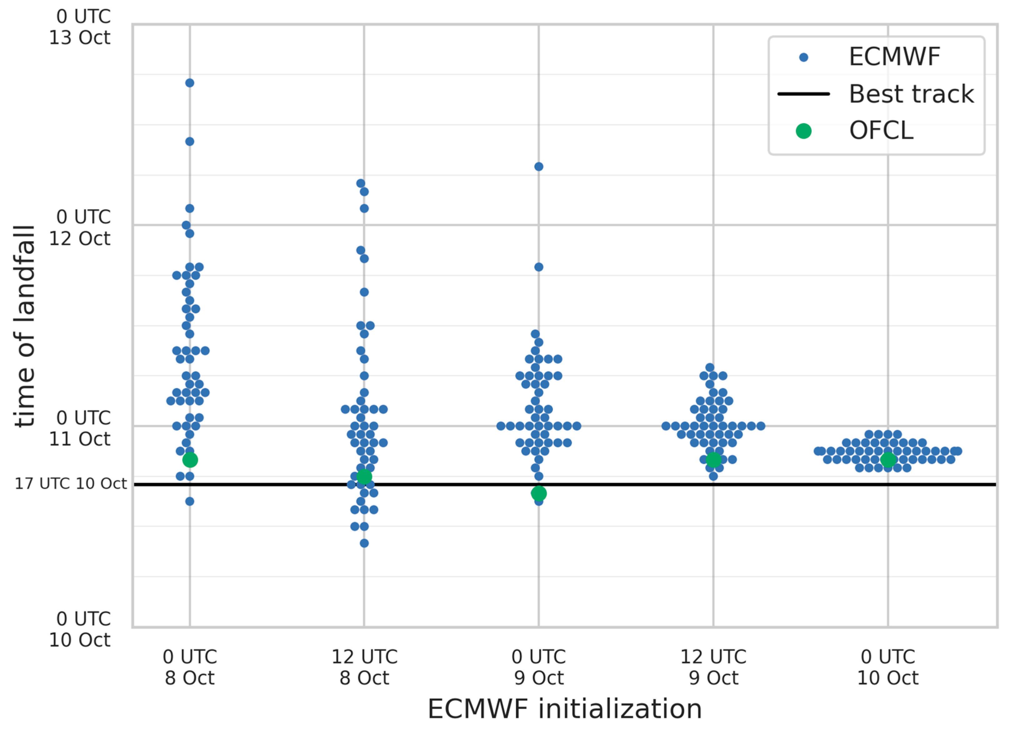
Ensemble spread in timing of TC landfall also decreases substantially with forecast lead time (Figure 9). For the 8 October initialization times, forecasts of TC landfall time span approximately 48 h. By the 0 UTC 9 October initialization time, this narrows to approximately 18 h, with two late-landfalling outliers. At these first three initialization times, landfall time and location are correlated: ensemble TCs with more western tracks tend to make landfall earlier and those with more eastern tracks tend to make landfall later. By the latter two initialization times, the TCs in all ensemble members make landfall within a 6–12 h period. Another noticeable aspect of Figure 9 is a bias in TC landfall time in the ensemble forecasts: at all five initialization times, most of the TCs in the ECMWF-derived ensembles make landfall later than Hurricane Michael’s actual landfall. In contrast, the five OFCL TC forecasts, which were generated in real time by NHC forecasters, make landfall within a few hours of Best track.
Ensemble variation in TC intensity is more complex (Figure 1 and Figure 3, Table 1). As forecast lead time decreases, ensemble spread in Vmax at a given time tends to decrease, and peak Vmax tends to increase. However, only a few ensemble TCs reach Hurricane Michael’s actual intensity. In addition, at several initialization times, many of the intensity-adjusted ensemble TCs reach Category 3 or 4 strength over the Gulf of Mexico but then drop to Category 1 or tropical storm strength by landfall. This temporal evolution differs from Best track Vmax, which does not begin decreasing until after landfall. This difference arises in part from how TC intensity evolves in the ECMWF ensemble members, and in part from how we scaled ensemble Vmax to OFCL, as discussed in Appendix A.
These features of the TC ensembles provide important context for interpreting subsequent results from the storm surge ensembles. In the next section, it will be shown that, despite some shortcomings of the meteorological aspects of the ensemble forecasts, they produce a realistic representation of the time-evolving, spatial distribution of probabilities of impactful storm surge in the region at risk.

4.2. Prediction and Predictability of TC Storm Surge at Multiple Lead Times

Next, we analyze how the TC ensemble forecasts discussed in Section 4.1 translate into skill and variability in TC–storm surge ensemble forecasts. Based on Hurricane Michael’s actual evolution, the five initialization times studied here represent lead times of approximately 18–66 h prior to landfall. This is equivalent to approximately 12–60 h before the arrival of Michael’s tropical storm force winds, which is when forecasters and emergency managers recommend having all pre-storm preparations completed.
We start by examining ensemble-derived probabilistic forecasts of inundation depth ≥ 1 m at different locations, shown in Figure 10. At the two 8 October initialization times, the TC–storm surge ensemble indicates that a swath of coastal Florida from the central panhandle to the Big Bend is at risk of substantial inundation (Figure 10a,b). Although many ensemble members’ TCs make landfall west of Best track, in the western Florida panhandle, the storm surge ensemble indicates that this region is at lower risk. Instead, the area at risk identified by the 8 October ensembles extends further east than the eventual ≥ 1 m inundation (Figure 10f), reflecting the Big Bend region’s greater susceptibility to storm surge. At these lead times, locations at risk typically have inundation probabilities between 5 and 45%. However, a few areas have probabilities exceeding 65%, indicating that more than 2 days before landfall, the ensemble identifies these locations as highly likely to experience substantial inundation.
At the two 9 October initialization times, the area at risk of inundation ≥ 1 m narrows (Figure 10c,d), consistent with decreasing spread in the TC ensemble. Moreover, at many of the locations inundated in the Best track simulation, the inundation probabilities predicted by the ensemble increase, exceeding 85% at 0 UTC 9 October and 95% 12 h later. At 0 UTC 10 October, the ensemble further narrows the area at risk, although there remain locations with some probability of inundation ≥ 1 m that do not experience this level of inundation in the Best track simulation. This progression in skill at predicting the probability of inundation ≥ 1 m at specific locations is reflected in the increase in BSS with initialization time, shown in Table 3. Forecasts of the probability of a lower level of inundation—0.3 m—show a similar progression in skill, but higher BSS, especially for earlier initialization times (Table 3).
Figure 11 depicts how ensemble forecasts of inundation magnitude and timing evolve with lead time. Consistent with the variability in TC track and timing (Figure 1a,b and Figure 3), the two ensembles initialized on 8 October exhibit substantial variability in both maximum inundation volume and inundation timing (Figure 11a,b). They also exhibit a substantial late bias in forecast inundation timing, corresponding to their late bias in forecast timing of TC landfall. With each subsequent initialization time, ensemble variability in inundation timing narrows further (Figure 11c–e). However, even for the 0 UTC 10 October initialization time, inundation volume varies substantially across the ensemble. By this time, the ensemble TCs’ landfall locations vary by only about 80 km, but smaller differences in TC track and other characteristics lead to variability in the magnitude of inundation. Analysis of individual ensemble members revealed that this variability is associated with differences in the extent of flooding along the coast and inland as well as differences in water levels in flooded areas. The contributions of different TC parameters to this variability are investigated further in the next section.
Overall, these results illustrate both the potential for extending storm surge prediction to longer lead times and its challenges. Approximately 2.5–3 days before storm landfall, the TC–storm surge ensemble approach used here is able to identify the major regions at risk of substantial inundation from Hurricane Michael, despite the wide range of TC tracks and the underprediction of even OFCL-scaled Vmax near landfall. As lead time decreases, the TC ensemble indicates decreased meteorological forecast uncertainty, and the storm surge ensemble narrows the area at high risk and likely timing of inundation. Despite these successes, however, even at 18 h before landfall, location-specific predictability of inundation depth is limited [17]. Our results suggest that this occurs because translating the TC ensemble forecasts into storm surge ensemble forecasts attenuates the relationship between decreasing lead time and decreased TC forecast uncertainty.

4.3. Sensitivity of Coastal Inundation to TC Parameters

Qualitative examination of TC–storm surge ensemble members suggested that certain storm characteristics tended to be associated with greater coastal inundation. For example, some of the highest volumes, depths, and areal extents of inundation were produced by TCs that made landfall further east in the Florida Panhandle than Best track and had a more eastward track after landfall, generating onshore winds that lasted for a longer time and extended further east into the susceptible Big Bend region. To explore these associations quantitatively, we extracted different TC parameters from the TC–storm surge ensemble members as described in Section 2.3 and then explored their relationships with maximum inundation volume. However, we anticipate that these relationships depend on the storm and the coastal region affected, as well as the characteristics and limitations of the TC ensemble used. With this in mind, we discuss high-level patterns in the results, with the goal of illustrating how the storm-specific parameterized TC ensemble approach used here can build new understanding about TC-induced storm surge and help elucidate TC–storm surge scenarios.
Figure 12 depicts the relationships between each ensemble member’s maximum inundation volume and its TC’s parameters at landfall for the three 0 UTC initialization times. Consistent with the discussion in Section 4.1, ensemble variability in all five TC parameters tends to decrease as forecast lead time decreases. As discussed in Section 4.2, variability in maximum inundation volume also decreases with lead time, but to a lesser extent. Considering these variables together, the relationships between TC parameters and inundation volume exhibit the most variability for the 0 UTC 8 October initialization. By the 0 UTC 10 October initialization (18 h before landfall), much of the joint variability has collapsed, and several of the relationships appear dominated by noise. In between, 1.5–2-day lead times appear more favorable for considering the relationships between TC parameters and inundation volume; the TC ensemble variability is sufficiently reduced so that relationships emerge for most of the TC parameters, but not so small that inundation is governed by interactions between more detailed aspects of the TC and the coastal geography.
To provide a broader perspective and further illustrate this approach’s potential, Table 4 presents correlations for the same results as Figure 12 alongside similar results for the TC parameters 6 h before and after landfall. Longitude exhibits the most consistent relationship with inundation volume, with TCs that track further east tending to produce more inundation across initialization times. Vmax and R34 also exhibit substantial relationships with inundation volume at multiple initialization times, especially for the TC parameters 6 h after landfall. In contrast, direction and forward speed are strongly related to inundation volume in the ensemble initialized at 0 UTC 9 October, but not the earlier or later times. The relationships with Vmax, R34, and forward speed are consistent with prior research indicating that more intense, larger, and slower moving storms tend to produce greater storm surge (e.g., [17,24,25,76,77,78,79]). These results for TC direction differ from some prior studies, which indicate that storms with tracks that make landfall perpendicular to a coastline tend to produce greater surge [24,78]; our results for relationships with direction and longitude are likely due to the position of the storm’s track relative to the Big Bend region.
The ensemble results reveal two additional aspects of Hurricane Michael’s storm surge. First, Figure 12 shows that at each initialization time, multiple ensemble members have TCs that produce substantially higher inundation volume than Best track. This indicates that the flooding caused by Michael’s storm surge could have been much worse, with a slightly different TC track or structure. Moreover, each TC–storm surge ensemble member corresponds to a dynamically and situationally realistic scenario that can be characterized in terms of TC parameters such as those in Table 4. This suggests another potential utility of this study’s ensemble method: highlighting physically realistic atmospheric scenarios that are likely to produce especially severe storm surge impacts. Such analysis could be conducted from a climatological perspective, or to provide information to support decision making in real time during a storm threat [14].
Figure 12 also shows that realistic alternative TC scenarios can produce substantially more inundation than Best track, even with Vmax values up to 70 kts weaker at landfall. This could be related to many of the ensemble TCs reaching peak intensity prior to landfall and subsequently weakening; however, Figure 3 shows that at 0 UTC 8 and 9 October, the highest Vmax that any ensemble TC member reaches is 15 kts weaker than Best track. In other words, although forecasting Hurricane Michael’s rapid intensification was critical for predicting wind impacts, our results suggest that it was not required to provide useful storm surge risk information [86].

5. Discussion

This study developed a method to parameterize and adjust tropical cyclones derived from atmospheric model ensembles, for use in generating storm surge ensembles. Through this approach, we seek to create TC–storm surge ensemble forecasts that capture the atmospheric uncertainty and physical characteristics inherent to an individual TC, while retaining the simplicity of using parametric vortices to simulate storm surge. The article illustrates the potential of this type of ensemble approach for storm surge prediction and predictability research. More generally, it also advances capacity for using global atmospheric model data for storm surge research, forecasting, and risk analyses.
We implemented the method using archived data from the ECMWF ensemble forecasts generated in real time at five initialization times, in conjunction with the ADCIRC dynamical storm surge model. We focus on storm surge forecasts at lead times of approximately one day or longer because that is when most coastal evacuation and preparation decisions are made, and because research indicates that storm surge forecasts are needed more than 48 h in advance for many coastal evacuation decisions [10,11,12,13,14]. Constructing and analyzing TC–storm surge ensemble forecasts across a range of lead times facilitates investigating the extent to which different aspects of forecast skill extend to longer lead times, as well as the TC characteristics that drive forecast variability at different lead times.
We find that the method produces a robust representation of storm surge inundation and associated forecast uncertainty, once parameterized TC intensity is adjusted using NHC’s official forecasts and missing wind radii are estimated. The results illustrate how Hurricane Michael’s storm surge could have been substantially more severe, with a variety of physically realistic TC scenarios represented within the ensembles. Moreover, the ensembles include TCs that have substantially lower intensity than Hurricane Michael at landfall but produce more storm surge inundation. This suggests that predicting Michael’s rapid intensification was not required to predict the storm surge risk posed by the storm—a potentially important result, given the current challenges of accurately predicting rapid hurricane intensification.
The study’s findings suggest that this approach to generating TC–storm surge ensembles has potential to provide forecast utility multiple days before landfall, by identifying areas at substantial risk of storm surge inundation. If such information could reliably be generated in near real time, it could help mobilize early protective actions. The results also illustrate the potential of this approach for understanding which TC parameters are most related to storm surge magnitude in different situations. Note, however, that several of the TC parameters investigated here are correlated in the ensembles, and so a multivariate analysis may be more informative. In addition, despite indicating general patterns, our results show that the relationships between TC parameters and inundation can vary substantially among ensemble members. As discussed in [19], this likely arises due to the complexity of how TCs interact hydrodynamically with local variations in coastline geography, bathymetry, and topography. Consequently, even 18 h before landfall, the storm surge ensemble forecasts exhibit significant spread in the magnitude of inundation. Together, these results highlight the potential for longer lead-time predictions of storm surge risk, as well as the challenges of predicting the details of storm surge inundation even at short lead times.
The method demonstrated here has several potential advantages relative to other methods of generating TC–storm surge ensembles. First, this approach for generating ensemble TC forcing is feasible to run in real time because the parameterized vortices can be generated very rapidly when global ensemble data become available. In addition, because the vortices are parameterized rather than based on gridded data, atmospheric model data available at 6 h intervals are sufficient to run ADCIRC. Further, this approach facilitates highlighting physically realistic scenarios within an ensemble that would produce especially severe impacts in a given TC situation, for impacts measured by maximum water level at specific locations, total inundation volume, or another metric. In these ways, this approach suggests a potential path forward for combining the potential real-time applicability of simpler ensemble storm surge forecasting techniques (e.g., [6,20,22,23]) with the meteorological realism of hindcast surge ensembles that are run with high-resolution atmospheric ensemble simulations (e.g., [15,16]).
The method has several limitations and areas for possible improvement. First, the algorithm that we used to adjust TC intensity in the ECMWF-derived ensemble forecasts does not account for differences in the timing of TC landfall. We chose to use a relatively simple intensity adjustment method as a starting point, to explore methods that could be implemented in near-real time; more complex methods could be investigated in follow-on work. In addition, at four of the five initialization times, the ensembles have a substantial bias in TC landfall time. This bias was not present in NHC’s official forecasts for Hurricane Michael, which suggests the potential for adjusting the parameterized TC ensembles’ timing along with intensity, at least for this storm. Although we did not try to ameliorate the timing bias in this study, doing so would be important for real-time forecasting, to provide reliable forecasts of how much time people at risk have to complete pre-storm preparations. Moreover, in areas with strong tidal variation, even a 6-h change in landfall time can make a large difference in the inundation experienced [15,16,73].
Another potential limitation of this approach is that parameterizing TCs from the atmospheric model simplifies their wind fields. Parameterizing TCs is common in storm surge research and forecasting, but additional work is needed to assess whether doing so as part of this method affects the forecast skill and other properties of the resulting storm surge ensembles. For example, parameterizing the storm’s vortex removed the far-field winds that likely contributed to Hurricane Michael’s inundation along the Florida coast, and the method demonstrated here could be expanded to fully account for the wind forcings that drive storm surge. In addition, for some TCs, adjusting Vmax could produce storms with unrealistically high intensities, and adjusting Vmax and Pmin without adjusting the model-derived wind radii could produce altered or unrealistic TC structures. Moreover, altering forecast parameters such as Vmax and Pmin independently of other parameters such as TC track could degrade the realism of the TC scenarios. To address these issues, a more dynamically informed, multivariate approach to adjusting parameterized TCs may be needed. Finally, the method is limited by the TC scenarios represented in the atmospheric model ensembles used. Since atmospheric model ensembles can be underdispersive and have other biases, it is important to consider an atmospheric ensemble’s characteristics when using the data to create storm surge ensembles and when interpreting the results.
Along with the topics noted above, the article suggests several additional areas for future research. One is implementing the method for additional TCs, to further test the method and investigate the topics addressed here across a wider range of cases. Because the method can use available atmospheric model data at different spatial and temporal resolutions, it can also be extended to other numerical weather prediction ensemble data or a multi-model ensemble. Another potential research topic is investigating how the TC intensity adjustment method used here compares with other methods for addressing TC intensity biases in atmospheric models, when the TC data are used in ensemble storm surge simulations. Also of interest is investigating how storm surge ensembles generated using this approach compare with those generated using systematic perturbations of TC parameters.
From a practical perspective, the approach used here provides a starting point for further work that may help improve operational storm surge ensemble forecasting. For example, because the approach developed here uses ensemble data to specify TC wind fields with a small number of parameters, it can provide a bridge from methods that use climatologically based or ad hoc TC perturbations towards hybrid methods that incorporate information from dynamical atmospheric model ensembles. Implementing this type of approach could enhance the reliability of ensemble storm surge forecasts and extend their utility to longer lead times, supporting protective decision making. More broadly, these methods may be useful for other types of work that involve simulating storm surge using atmospheric model data that do not fully resolve TCs’ structures, has other known biases, or has output available at limited time intervals. This includes storm surge research and risk analyses using archived data from operational weather prediction models, atmospheric reanalyses, and climate simulations.

Author Contributions

Conceptualization, R.E.M., D.A., K.R.F., A.M.K. and C.A.D.; methodology, R.E.M., D.A., K.R.F., A.M.K. and C.A.D.; software, D.A. and K.R.F.; validation, R.E.M., D.A. and K.R.F.; formal analysis, D.A.; investigation, R.E.M., D.A. and K.R.F.; resources, D.A. and K.R.F.; data curation, D.A.; writing—original draft preparation, R.E.M., D.A. and A.M.K.; writing—review and editing, R.E.M., D.A., K.R.F., A.M.K. and C.A.D.; visualization, D.A.; supervision, R.E.M. and K.R.F.; project administration, R.E.M. and K.R.F.; funding acquisition, R.E.M., K.R.F. and C.A.D. All authors have read and agreed to the published version of the manuscript.

Funding

This material is based upon work supported by the NSF National Center for Atmospheric Research (NCAR), which is a major facility sponsored by the U.S. National Science Foundation under Cooperative Agreement number 1852977. This research was also funded in part by U.S. National Science Foundation grant number 1331490.

Data Availability Statement

The raw data supporting the conclusions of this article will be made available by the authors on request.

Acknowledgments

We thank Ryan Torn for providing the ECMWF ensemble A-deck files and Rick Luettich for assistance with reconciling different types of wind inputs with the ADCIRC code. This material is based upon work conducted while R.M. was serving at the U.S. National Science Foundation (NSF). We acknowledge high-performance computing support from Cheyenne (doi:10.5065/D6RX99HX) and Derecho (doi:10.5065/qx9a-pg09) provided by NCAR’s Computational and Information Systems Laboratory, sponsored by NSF. This work is also based on data from TIGGE (The International Grand Global Ensemble), which is an initiative of the World Weather Research Programme (WWRP). Analysis was aided by adcircpy [87]. Any opinion, findings, and conclusions or recommendations expressed in this material are those of the author and do not necessarily reflect the views of NSF.

Conflicts of Interest

The authors declare no conflicts of interest. The funders had no role in the design of the study; in the collection, analyses, or interpretation of data; in the writing of the manuscript; or in the decision to publish the results.

Appendix A. Adjusting Ensemble Vmax

As described in Section 2, for each initialization time, we scaled ensemble TC Vmax using the NHC OFCL forecast issued at a corresponding time. To keep the ensemble Vmax consistent with the ensemble wind radii, which represent V10, we first converted the Vmax1 values in OFCL to Vmax10. Next, at each OFCL forecast time, we divided the OFCL Vmax10 by the ensemble mean Vmax10 to obtain a scaling factor, with a minimum of 1.0. We then interpolated these scaling factors to the ECMWF forecast times (every 6 h) and multiplied each ensemble member’s Vmax at each forecast time by the corresponding scaling factor. For each initialization time, this produces an ensemble of parameterized TC forecasts whose mean Vmax parallels the evolution of OFCL Vmax with time (right hand side of Figure 3). We set the minimum scaling factor to 1.0 to avoid decreasing any of the ensemble TC’s Vmax values around the time of landfall; this was important because, as shown in Figure 9, many of the ensemble TCs make landfall later than the TC in OFCL.
One area for possible improvement in this method is that it scales ensemble mean Vmax to OFCL Vmax at specific times, without accounting for differences in when the TCs in different ensemble members make landfall. This, combined with the 12 or 24 h interval between OFCL forecast times (Figure 3), leads many of the intensity-adjusted ensemble members’ TCs to reach peak intensity prior to landfall (Figure 1). However, the results show that this does not lead to a low bias in storm surge inundation, and the method achieves the goal of reducing the atmospheric model’s TC intensity bias in a simple way that could be readily implemented in real time.

Appendix B. Estimating Pmin

After scaling ensemble Vmax, we estimated a new Pmin for each parameterized ensemble TC using the wind-pressure relationship in Equation (7) of [69], in which Pmin is a function of Vmax1, storm translation speed, normalized storm size, storm latitude, and environmental pressure. For this calculation, we converted each TC’s Vmax10 to Vmax1 by dividing by one2ten (see Section 2 and [88]). The other four parameters were estimated using the corresponding gridded ECMWF data. Normalized storm size was calculated as the ratio of the tangential wind at 500 km (V500) to the climatological V500 (V500c), with V500 estimated as 400–600 km azimuthal-mean tangential wind and V500c estimated using Equations (4)–(6) in [69]. Environmental pressure was estimated as 800–1000 km azimuthal-mean sea level pressure.

Appendix C. Estimating Missing Wind Radii

As summarized in Section 2.1.3, we found that after scaling ensemble Vmax, it was important to fill in missing wind radii for some ensemble TCs. First, to avoid producing infeasible wind radii, we used OFCL to estimate maximum and minimum values for Hurricane Michael’s R50 and R64. To do so, we identified the maximum and minimum R50 and R64 values across the five OFCL files corresponding to the five initialization times, and then added 5 nmi to the maximum values and subtracted 5 nmi from the minimum values. For simplicity, we used the same minimum and maximum values across all initialization times and all four storm quadrants. The resulting values are R50min = 15 nmi, R50max = 75 nmi, R64min = 10 nmi, and R64max = 45 nmi. While these values are approximations, they were used only as upper and lower thresholds to prevent generating wind radii that are unrealistic for Hurricane Michael.
Next, for each of the five initialization times, we used the corresponding OFCL forecast to calculate average R50:R34 and R64:R50 ratios in each quadrant, using all forecast times for which both wind radii were available. The resulting R50:R34 ratios ranged from 0.33 to 0.53 and the resulting R64:R50 ratios from 0.40 to 0.65, depending on the initialization time and quadrant. We derived these ratios using OFCL to simulate forecast information about the storm’s size available in real time, but averaged across multiple OFCL forecast times to reduce temporal variability in how missing wind radii were estimated.
Then, for the TC in each forecast time in each ensemble member, starting with the earliest forecast time, we followed these steps:
  • If Vmax ≥ 34 and R34 was missing for a quadrant, we set that R34 to that quadrant’s R34 at the previous forecast time. If no previous R34 was available (i.e., if this was the initial time), we set that R34 to the smallest value of R34 in the other quadrants at that time.
  • If Vmax ≥ 50 and R50 was missing for a quadrant, we estimated that R50 by multiplying that quadrant’s R34 by its R50:R34 ratio for that initialization time and rounding to the nearest whole number. If the resulting estimated R50 was less than R50min, we left that R50 missing; if it was greater than R50max, we set it to R50max.
  • If Vmax ≥ 64 and R64 was missing for a quadrant, we estimated that R64 by multiplying that quadrant’s R50 by its R64:R50 ratio for that initialization time and rounding to the nearest whole number. If the resulting estimated R64 was less than R64min, we left that R64 missing; if it was greater than R64max, we set it to R64max.
Note that this method does leave some missing R50 or R64 values, when the R50 or R64 estimated using the ratio is lower than the minimum value. This is consistent with the parameterized TCs generated by NHC, which do occasionally have missing wind radii. This method can also add an R50 (R64) to an ensemble TC in which Vmax is not scaled and the ECMWF data had no 50 kt (64 kt) winds in that quadrant. However, these situations only occur when the extent of the wind field in a quadrant is small, based on the available wind radii. Thus, this aspect of the method does not substantially change the simulated storm surge, i.e., it does not have the types of negative effects illustrated by the Best track experiments with missing wind radii shown in Figure 7.
Although missing R34 values were rare, step 1 was important, because the GAHM implemented in ADCIRC produced very large wind fields in quadrants with no wind radii specified. Estimating missing R34, R50, and, to a lesser extent, R64 values was most important for ensemble members with intense TCs around the time of landfall. In some of these cases, the 6 h interval between forecast times combined with rapidly decreasing Vmax after landfall led to unrealistically large TC wind fields in one or more quadrants. When this occurred in the southeast quadrant, it resulted in inundation that was anomalously large compared to TCs with similar tracks. Experimentation with this method indicated that the most important aspects were identifying potentially problematic missing wind radii and filling them in using a reasonable approach; changing the specific parameter values used within the method did not meaningfully change the ensemble storm surge results.

References

  1. Rappaport, E.N. Fatalities in the United States from Atlantic tropical cyclones: New data and interpretation. Bull. Am. Meteorol. Soc. 2014, 95, 341–346. [Google Scholar] [CrossRef]
  2. Bouwer, L.M.; Jonkman, S.N. Global mortality from storm surges is decreasing. Environ. Res. Lett. 2018, 13, 014008:1–014008:7. [Google Scholar] [CrossRef]
  3. Forbes, C.; Rhome, J.; Mattocks, C.; Taylor, A. Predicting the storm surge threat of Hurricane Sandy with the National Weather Service SLOSH model. J. Mar. Sci. Eng. 2014, 2, 437–476. [Google Scholar] [CrossRef]
  4. Morrow, B.H.; Lazo, J.K.; Rhome, J.; Feyen, J. Improving storm surge risk communication: Stakeholder perspectives. Bull. Am. Meteorol. Soc. 2015, 96, 35–48. [Google Scholar] [CrossRef]
  5. Bilskie, M.V.; Asher, T.G.; Miller, P.W.; Fleming, J.G.; Hagen, S.C.; Luettich, R.A., Jr. Real-time simulated storm surge predictions during Hurricane Michael (2018). Weather Forecast. 2022, 37, 1085–1102. [Google Scholar] [CrossRef]
  6. Penny, A.B.; Alaka, L.; Taylor, A.A.; Booth, W.; DeMaria, M.; Fritz, C.; Rhome, J. Operational storm surge forecasting at the National Hurricane Center: The Case for probabilistic guidance and the evaluation of improved storm size forecasts used to define the wind forcing. Weather Forecast. 2023, 38, 2461–2479. [Google Scholar] [CrossRef]
  7. Lee, J.-W.; Irish, J.L.; Bensi, M.T.; Marcy, D.C. Rapid prediction of peak storm surge from tropical cyclone track time series using machine learning. Coast. Eng. 2021, 170, 104024:1–1104024:17. [Google Scholar] [CrossRef]
  8. Bao, D.; Xue, Z.G.; Warner, J.C.; Moulton, M.; Yin, D.; Hegermiller, C.A.; Zambon, J.B.; He, R. A numerical investigation of Hurricane Florence-induced compound flooding in the Cape Fear Estuary using a dynamically coupled hydrological-ocean model. J. Adv. Model. Earth Syst. 2022, 14, e2022MS003131:1–e2022MS003131:24. [Google Scholar] [CrossRef]
  9. Ayyad, M.; Orton, P.M.; El Safty, H.; Chen, Z.; Hajj, M.R. Ensemble forecast for storm tide and resurgence from Tropical Cyclone Isaias. Weather Clim. Extr. 2022, 38, 100504:1–100504:10. [Google Scholar] [CrossRef]
  10. Losego, J.L.; Galluppi, K.J.; Montz, B.E.; Smith, C.F.; Schotz, S. Weather for emergency management: Implications for NWS tropical weather products and services. In Proceedings of the Seventh American Meteorological Society Symposium on Policy and Socio-economic Research, New Orleans, LA, USA, 22–26 January 2012; Available online: https://ams.confex.com/ams/92Annual/webprogram/Manuscript/Paper197676/Losego_etal_2012%20Ext%20Manuscript_Final.pdf (accessed on 9 March 2024).
  11. Morrow, B.H.; Lazo, J.K. Coastal emergency managers’ preferences for storm surge forecast communication. J. Emerg. Manag. 2014, 12, 153–160. [Google Scholar] [CrossRef]
  12. Munroe, R.; Montz, B.; Curtis, S. Getting more out of storm surge forecasts: Emergency support personnel needs in North Carolina. Weather Clim. Soc. 2018, 10, 813–820. [Google Scholar] [CrossRef]
  13. Morss, R.E.; Vickery, J.; Lazrus, H.; Demuth, J.; Bostrom, A. Improving tropical cyclone forecast communication by understanding NWS partners’ decision timelines and forecast information needs. Weather Clim. Soc. 2022, 14, 783–800. [Google Scholar] [CrossRef]
  14. Morss, R.E.; Vickery, J.; Bostrom, A.; Demuth, J.L.; Lazrus, H.; Laidlaw, E.L.; Hadjimichael, N. Modernizing the NWS Tropical Cyclone Product Suite by Evaluating NWS Partner Decisions and Information Needs: Cross-Method Synthesis of Key Findings and Recommendations. 2022. Available online: https://repository.library.noaa.gov/view/noaa/47955 (accessed on 6 April 2024).
  15. Colle, B.A.; Bowman, M.J.; Roberts, K.J.; Bowman, M.H.; Flagg, C.N.; Kuang, J.; Weng, Y.; Munsell, E.B.; Zhang, F. Exploring water level sensitivity for metropolitan New York during Sandy (2012) using ensemble storm surge simulations. J. Mar. Sci. Eng. 2015, 3, 428–443. [Google Scholar] [CrossRef]
  16. Kowaleski, A.; Morss, R.E.; Ahijevych, D.; Fossell, K.R. Using a WRF-ADCIRC ensemble and track clustering to investigate storm surge hazards and inundation scenarios associated with Hurricane Irma. Weather Forecast. 2020, 35, 1289–1315. [Google Scholar] [CrossRef]
  17. Fossell, K.R.; Ahijevych, D.; Morss, R.E.; Snyder, C.; Davis, C. The practical predictability of storm tide from tropical cyclones in the Gulf of Mexico. Mon. Weather Rev. 2017, 145, 5103–5121. [Google Scholar] [CrossRef]
  18. Dietrich, J.C.; Muhammad, A.; Curcic, M.; Fathi, A.; Dawson, C.; Chen, S.; Luettich, R., Jr. Sensitivity of storm surge predictions to atmospheric forcing during Hurricane Isaac. J. Waterw. Port Coast. Ocean Eng. 2017, 144, 04017035:1–04017035:24. [Google Scholar] [CrossRef]
  19. Camelo, J.; Mayo, T.L.; Gutmann, E.D. Projected climate change impacts on hurricane storm surge inundation in the coastal United States. Front. Built Environ. 2020, 6, 588049:1–588049:16. [Google Scholar] [CrossRef]
  20. Kohno, N.; Dube, S.K.; Entel, M.; Fakhruddin, S.H.M.; Greenslade, D.; Leroux, M.D.; Rhome, J.; Thuy, N.B. Recent progress in storm surge forecasting. Trop. Cyclone Res. Rev. 2018, 7, 128–139. [Google Scholar] [CrossRef]
  21. Taylor, A.A.; Glahn, B. Probabilistic guidance for hurricane storm surge. In Proceedings of the 88th Annual Meeting of the American Meteorological Society, New Orleans, LA, USA, 20–24 January 2008; Available online: http://www.nws.noaa.gov/mdl/pubs/Documents/Papers/psurge_ofcl_200801_AMS.pdf (accessed on 8 February 2024).
  22. Fleming, J.; Fulcher, C.; Luettich, R.A., Jr.; Estrade, B.; Allen, G.; Winer, H. A real time storm surge forecasting system using ADCIRC. In Proceedings of the 10th International Conference on Estuarine and Coastal Modeling, Newport, RI, USA, 5–7 November 2007; ASCE: Reston, VA, USA, 2008; pp. 893–912. [Google Scholar] [CrossRef]
  23. Davis, J.R.; Paramygin, V.A.; Forrest, D.; Sheng, Y.P. Towards the probabilistic simulation of storm surge and inundation in a limited resource environment. Mon. Weather Rev. 2010, 138, 2953–2974. [Google Scholar] [CrossRef]
  24. Irish, J.L.; Resio, D.T.; Ratcliff, J.J. The influence of storm size on hurricane surge. J. Phys. Oceanogr. 2008, 38, 2003–2013. [Google Scholar] [CrossRef]
  25. Rego, J.L.; Li, C. On the importance of the forward speed of hurricanes in storm surge forecasting: A numerical study. Geophys. Res. Lett. 2009, 36, L07609:1–L07609:5. [Google Scholar] [CrossRef]
  26. Lin, C.-W.; Wu, T.-R.; Tsai, Y.-L.; Chuang, S.-C.; Chu, C.-H.; Terng, C.-T. Member formation methods evaluation for a storm surge ensemble forecast system in Taiwan. Water 2023, 15, 1826. [Google Scholar] [CrossRef]
  27. Pringle, W.J.; Burnett, Z.; Sargsyan, K.; Moghimi, S.; Myers, E. Efficient probabilistic prediction and uncertainty quantification of tropical cyclone–driven storm tides and inundation. Artif. Intell. Earth Syst. 2023, 2, e220040:1–e220040:19. [Google Scholar] [CrossRef]
  28. Bloemendaal, N.; Muis, S.; Haarsma, R.J.; Verlaan, M.; Irazoqui Apecechea, M.; de Moel, H.; Ward, P.J.; Aerts, J.C.J.H. Global modeling of tropical cyclone storm surges using high-resolution forecasts. Clim. Dyn. 2019, 52, 5031–5044. [Google Scholar] [CrossRef]
  29. Torres, M.J.; Hashemi, M.R.; Hayward, S.; Spaulding, M.; Ginis, I.; Grilli, S.T. Role of hurricane wind models in accurate simulation of storm surge and waves. J. Waterw. Port Coast. Ocean. Eng. 2019, 145, 04018039:1–04018039:17. [Google Scholar] [CrossRef]
  30. Dullaart, J.C.M.; Muis, S.; Bloemendaal, N.; Aerts, J.C.J.H. Advancing global storm surge modelling using the new ERA5 climate reanalysis. Clim. Dyn. 2020, 54, 1007–1021. [Google Scholar] [CrossRef]
  31. Murty, P.L.N.; Siva Srinivas, K.; Rama Rao, E.P.; Bhaskaran, P.K.; Shenoi, S.S.C.; Padmanabham, J. Improved cyclonic wind fields over the Bay of Bengal and their application in storm surge and wave computations. Appl. Ocean Res. 2020, 95, 102048:1–102048:12. [Google Scholar] [CrossRef]
  32. Zhang, F.; Li, M.; Ross, A.C.; Lee, S.B.; Zhang, D. Sensitivity analysis of Hurricane Arthur (2014) storm surge forecasts to WRF physics parameterizations and model configurations. Weather Forecast. 2017, 32, 1745–1764. [Google Scholar] [CrossRef]
  33. Blanton, B.; Dresback, K.; Colle, B.; Kolar, R.; Vergara, H.; Hong, Y.; Leonardo, N.; Davidson, R.; Nozick, L.; Wachtendorf, T. An integrated scenario ensemble-based framework for hurricane evacuation modeling: Part 2Hazard Modeling. Risk Anal. 2018, 40, 117–133. [Google Scholar] [CrossRef]
  34. Mohanty, S.; Nadimpalli, R.; Mohanty, U.C.; Pattanayak, S. Storm surge prediction improvement using high resolution meso-scale model products over the Bay of Bengal. Nat. Hazards 2024, 120, 1185–1213. [Google Scholar] [CrossRef]
  35. Lin, N.; Chavas, D. On hurricane parametric wind and applications in storm surge modeling. J. Geophys. Res. Atmos. 2012, 117, D09120:1–D09120:19. [Google Scholar] [CrossRef]
  36. Ramos Valle, A.N.; Curchitser, E.N.; Bruyere, C.L.; Fossell, K.R. Simulating storm surge impacts with a coupled atmosphere-inundation model with varying meteorological forcing. J. Mar. Sci. Eng. 2018, 6, 35. [Google Scholar] [CrossRef]
  37. Mayo, T.; Lin, N. The effect of the surface wind field representation in the operational storm surge model of the National Hurricane Center. Atmosphere 2019, 10, 193. [Google Scholar] [CrossRef]
  38. Beven, J.L., II; Berg, R.; Hagen, A. Tropical Cyclone Report: Hurricane Michael (AL142018), 7 October–11 October 2018. Technical Report, NOAA/National Hurricane Center. 2019. Available online: https://www.nhc.noaa.gov/data/tcr/AL142018_Michael.pdf (accessed on 15 November 2020).
  39. Davis, J.; Mitsova, D.; Briggs, T.C.; Briggs, T.R. Post-Hurricane Michael damage assessment using ADCIRC storm surge hindcast, image classification, and LiDAR. Shore Beach 2019, 87, 3–14. [Google Scholar] [CrossRef]
  40. Hazelton, A.T.; Zhang, X.; Gopalakrishnan, S.; Ramstrom, W.; Marks, F.; Zhang, J.A. High-resolution ensemble HFV3 forecasts of Hurricane Michael (2018): Rapid intensification in shear. Mon. Weather Rev. 2020, 148, 2009–2032. [Google Scholar] [CrossRef]
  41. Torn, R.D.; DeMaria, M. Validation of ensemble-based probabilistic tropical cyclone intensity change. Atmosphere 2021, 12, 373. [Google Scholar] [CrossRef]
  42. Alland, J.J.; Davis, C.A. Effects of surface fluxes on ventilation pathways and the intensification of Hurricane Michael (2018). J. Atmos. Sci. 2022, 79, 1211–1229. [Google Scholar] [CrossRef]
  43. Molteni, F.; Buizza, R.; Palmer, T.N.; Petroliagis, T. The ECMWF Ensemble Prediction System: Methodology and validation. Q. J. R. Meteorol. Soc. 1996, 122, 73–119. [Google Scholar] [CrossRef]
  44. Luettich, R.A., Jr.; Westerink, J.J.; Scheffner, N.W. ADCIRC: An Advanced Three-Dimensional Circulation Model for Shelves, Coasts, and Estuaries; Report 1, Theory and Methodology of ADCIRC-2DDI and ADCIRC-3DL; Coastal Engineering Research Center: Vicksburg, MS, USA, 1992. [Google Scholar]
  45. Kim, S.W.; Melby, J.A.; Nadal-Caraballo, N.C.; Radcliff, J. A time-dependent surrogate model for storm surge prediction based on an artificial neural network using high-fidelity synthetic hurricane modeling. Nat. Hazards 2015, 76, 565–585. [Google Scholar] [CrossRef]
  46. Nezhad, S.K.; Barooni, M.; Velioglu Sogut, D.; Weaver, R.J. Ensemble neural networks for the development of storm surge flood modeling: A comprehensive review. J. Mar. Sci. Eng. 2023, 11, 2154. [Google Scholar] [CrossRef]
  47. Gladwin, C.H.; Gladwin, H.; Peacock, W.G. Modeling hurricane evacuation decisions with ethnographic methods. Int. J. Mass Emerg. Disasters 2001, 19, 117–143. [Google Scholar] [CrossRef]
  48. Dash, N.; Gladwin, H. Evacuation decision making and behavioral responses: Individual and household. Nat. Hazards Rev. 2007, 8, 69–77. [Google Scholar] [CrossRef]
  49. Morss, R.E.; Hayden, M.H. Storm surge and “certain death”: Interviews with Texas coastal residents following Hurricane Ike. Weather Clim. Soc. 2010, 2, 174–189. [Google Scholar] [CrossRef]
  50. Demuth, J.L.; Morss, R.E.; Palen, L.; Anderson, K.M.; Anderson, J.; Kogan, M.; Stowe, K.; Bica, M.; Lazrus, H.; Wilhelmi, O.; et al. “Sometimes da #beachlife ain’t always da wave”: Understanding people’s evolving hurricane risk communication, risk assessments, and responses using Twitter narratives. Weather Clim. Soc. 2018, 10, 537–560. [Google Scholar] [CrossRef]
  51. Lazrus, H.; Wilhelmi, O.; Morss, R.; Henderson, J.; Dietrich, A. Information as intervention: How hurricane risk communication interacted with vulnerability and capacities in Hurricane Sandy. Int. J. Mass Emerg. Disasters 2020, 38, 89–120. [Google Scholar] [CrossRef]
  52. Senkbeil, J.; Collins, J.; Reed, J. Evacuee perception of geophysical hazards for Hurricane Irma. Weather Clim. Soc. 2019, 11, 217–227. [Google Scholar] [CrossRef]
  53. Milch, K.; Broad, K.; Orlove, B.; Meyer, R. Decision science perspectives on hurricane vulnerability: Evidence from the 2010–2012 Atlantic hurricane seasons. Atmosphere 2018, 9, 32. [Google Scholar] [CrossRef]
  54. Millet, B.; Carter, A.P.; Broad, K.; Cairo, A.; Evans, S.D.; Majumdar, S.J. Hurricane risk communication: Visualization and behavioral science concepts. Weather Clim. Soc. 2020, 12, 193–211. [Google Scholar] [CrossRef]
  55. Wilhelmi, O.; Morss, R.E.; Lazrus, H.; Boehnert, J.; Gambill, J.M. Examining the roles of visualizations in people’s understanding of uncertain storm surge forecasts, interpretation of risk, and decision-making. Int. J. Disaster Risk Reduct. 2024, 107, 104424:1. [Google Scholar] [CrossRef]
  56. Luettich, R., Jr.; Westerink, J. Formulation and Numerical Implementation of the 2D/3D ADCIRC Finite Element Model Version 44; University of North Carolina: Chapel Hill, NC, USA, 2004; Available online: https://adcirc.org/wp-content/uploads/sites/2255/2018/11/adcirc_theory_2004_12_08.pdf (accessed on 8 February 2024).
  57. ADCIRC Github Repo Version 55.02. Available online: https://github.com/adcirc/adcirc.git (accessed on 8 March 2024).
  58. Luettich, R.A., Jr.; Westerink, J.J. ADCIRC User’s Manual—V53. 2018. Available online: https://adcirc.org/home/documentation/ (accessed on 8 February 2024).
  59. Landsea, C.W.; Franklin, J.L. Atlantic hurricane database uncertainty and presentation of a new database format. Mon. Weather Rev. 2013, 141, 3576–3592. [Google Scholar] [CrossRef]
  60. Luettich, R., Jr.; University of North Carolina, Morehead City, NC, USA. Personal communication, 2020.
  61. Magnusson, L.; Dahoui, M.; Velden, C.S.; Olander, T.L. A Fresh Look at Tropical Cyclone Intensity Estimates. In ECMWF Newsletter, Number 152—Summer 2017; Available online: https://www.ecmwf.int/en/newsletter/152/news/fresh-look-tropical-cyclone-intensity-estimates (accessed on 7 March 2024).
  62. ECMWF. IFS Documentation—Cy45r1; Operational Implementation 5 June 2018; Part V: Ensemble Prediction System. 2018. Available online: https://www.ecmwf.int/sites/default/files/elibrary/2018/80896-ifs-documentation-cy45r1-part-v-ensemble-prediction-system_1.pdf (accessed on 26 January 2024).
  63. Bougeault, P.; Toth, Z.; Bishop, C.; Brown, B.; Burridge, D.; Chen, D.H.; Ebert, B.; Fuentes, M.; Hamill, T.M.; Mylne, K.; et al. The THORPEX Interactive Grand Global Ensemble. Bull. Am. Meteorol. Soc. 2010, 91, 1059–1072. [Google Scholar] [CrossRef]
  64. Swinbank, R.; Kyouda, M.; Buchanan, P.; Froude, L.; Hamill, T.M.; Hewson, T.D.; Keller, J.H.; Matsueda, M.; Methven, J.; Pappenberger, F.; et al. The TIGGE project and its achievements. Bull. Am. Meteorol. Soc. 2016, 97, 49–67. [Google Scholar] [CrossRef]
  65. Magnusson, L.; Bidlot, J.-R.; Bonavita, M.; Brown, A.; Browne, P.; De Chiara, G.; Dahoui, M.; Lang, S.T.K.; McNally, T.; Mogensen, K.S.; et al. ECMWF activities for improved hurricane forecasts. Bull. Am. Meteorol. Soc. 2019, 100, 445–458. [Google Scholar] [CrossRef]
  66. Aijaz, S.; Kepert, J.D.; Ye, H.; Huang, Z.; Hawksford, A. Bias correction of tropical cyclone parameters in the ECMWF Ensemble Prediction System in Australia. Mon. Weather Rev. 2019, 147, 4261–4285. [Google Scholar] [CrossRef]
  67. Bidlot, J.-R.; Prates, F.; Ribas, R.; Mueller-Quintino, A.; Crepulja, M.; Vitart, F. Enhancing Tropical Cyclone Wind Forecasts. In ECMWF Newsletter, Number 164—Summer 2020; Available online: https://www.ecmwf.int/en/newsletter/164/meteorology/enhancing-tropical-cyclone-wind-forecasts (accessed on 8 March 2024).
  68. Majumdar, S.J.; Magnusson, L.; Bechtold, P.; Bidlot, J.R.; Doyle, J.D. Advanced tropical cyclone prediction using the experimental global ECMWF and operational regional COAMPS-TC systems. Mon. Weather Rev. 2023, 151, 2029–2048. [Google Scholar] [CrossRef]
  69. Knaff, J.A.; Zehr, R.M. Reexamination of tropical cyclone wind–pressure relationships. Weather Forecast. 2007, 22, 71–88. [Google Scholar] [CrossRef]
  70. Riverside Technology and AECOM. Mesh Development, Tidal Validation, and Hindcast Skill Assessment of an ADCIRC Model for the Hurricane Storm Surge Operational Forecast System on the US Gulf-Atlantic Coast; Riverside Technology, Inc.: Fort Collins, CO, USA, 2005. [Google Scholar] [CrossRef]
  71. Feyen, J.; Vinogradov, S.; Asher, T.G.; Halgren, J.; Funakoshi, Y. 2015: Development of Operational Storm Surge Guidance to Support Total Water Predictions. In Proceedings of the 14th International Workshop on Wave Hindcasting and Forecasting/Fifth Coastal Hazard Symposium, Key West, FL, USA, 8–13 November 2015; Available online: http://www.waveworkshop.org/14thWaves/Presentations/X3_Feyen_Waves_OpsSurgeGuidance_Nov2015-FINAL.pdf (accessed on 9 March 2024).
  72. Asher, T.G.; Luettich, R.A., Jr.; Fleming, J.G.; Blanton, B.O. Low frequency water level correction in storm surge models using data assimilation. Ocean Model. 2019, 144, 101483:1–101483:17. [Google Scholar] [CrossRef] [PubMed]
  73. Thomas, A.; Dietrich, J.C.; Asher, T.; Bell, M.; Blanton, B.; Copeland, J.; Cox, A.; Dawson, C.; Fleming, J.; Luettich, R., Jr. Influence of storm timing and forward speed on tides and storm surge during Hurricane Matthew. Ocean Model. 2019, 137, 1–19. [Google Scholar] [CrossRef]
  74. Byrne, M.J., Sr. Monitoring Storm Tide from Hurricane Michael along the Northwest Coast of Florida, October 2018. U.S. Geological Survey Open-File Report 2019–1059, USGS. 2019. Available online: https://pubs.usgs.gov/publication/ofr20191059 (accessed on 26 January 2024).
  75. Brier, G.W. Verification of forecasts expressed in terms of probability. Mon. Weather Rev. 1950, 78, 1–3. [Google Scholar] [CrossRef]
  76. Needham, H.F.; Keim, B.D. Correlating storm surge heights with tropical cyclone winds at and before landfall. Earth Interact. 2014, 18, 1–26. [Google Scholar] [CrossRef]
  77. Needham, H.F.; Keim, B.D. An empirical analysis on the relationship between tropical cyclone size and storm surge heights along the U.S. Gulf Coast. Earth Interact. 2014, 18, 1–15. [Google Scholar] [CrossRef]
  78. Ramos Valle, A.N.; Curchitser, E.N.; Bruyere, C.L. Impact of tropical cyclone landfall angle on storm surge along the Mid-Atlantic Bight. J. Geophys. Res. Atmos. 2020, 125, e2019JD031796:1–e2019JD031796:19. [Google Scholar] [CrossRef]
  79. Kyprioti, A.P.; Adeli, E.; Taflanidis, A.A.; Westerink, J.J.; Tolman, H.L. Probabilistic storm surge estimation for landfalling hurricanes: Advancements in computational efficiency using quasi-Monte Carlo techniques. J. Mar. Sci. Eng. 2021, 9, 1322. [Google Scholar] [CrossRef]
  80. van Ormondt, M.; van Dongeren, A.; Roelvink, D. A semi-empirical method for computing storm surges on open coasts during tropical cyclones. Coast. Eng. 2021, 165, 103839:1–103839:26. [Google Scholar] [CrossRef]
  81. Jordan, M.R., II; Clayson, C.A. A new approach to using wind speed for prediction of tropical cyclone generated storm surge. Geophys. Res. Lett. 2008, 35, L13802:1–L13802:3. [Google Scholar] [CrossRef]
  82. Yang, K.; Paramygin, V.A.; Sheng, Y.P. A rapid forecasting and mapping system of storm surge and coastal flooding. Weather Forecast. 2020, 35, 1663–1681. [Google Scholar] [CrossRef]
  83. Lin, N.; Lane, P.; Emanuel, K.A.; Sullivan, R.M.; Donnelly, J.P. Heightened hurricane surge risk in northwest Florida revealed from climatological-hydrodynamic modeling and paleo-record reconstruction. J. Geophys. Res. Atmos. 2014, 119, 8606–8623. [Google Scholar] [CrossRef]
  84. Vijayan, L.; Huang, W.; Ma, M.; Ozguven, E.; Ghorbanzadeh, M.; Yang, J.; Yang, Z. Improving the accuracy of hurricane wave modeling in Gulf of Mexico with dynamically-coupled SWAN and ADCIRC. Ocean Eng. 2023, 274, 114044:1–114044:14. [Google Scholar] [CrossRef]
  85. A World of Weather: Fundamentals of Meteorology: 5b. More on Ensemble Forecasting. Available online: https://www.e-education.psu.edu/worldofweather/s12.html (accessed on 7 March 2024).
  86. Lockwood, J.W.; Lin, N.; Gori, A.; Oppenheimer, M. Increasing flood hazard posed by tropical cyclone rapid intensification in a changing climate. Geophys. Res. Lett. 2024, 51, e2023GL105624:1–e2023GL105624:10. [Google Scholar] [CrossRef]
  87. Calzada, J.; Burnett, Z.; Moghimi, S.; Myers, E.; Pe’eri, S. ADCIRCpy: A Python API to Generate ADCIRC Model Input Files. NOAA NOS OCS Technical Memorandum No. 41. 2021. Available online: https://pypi.org/project/adcircpy/ (accessed on 7 March 2024).
  88. Courtney, J.; Knaff, J.A. 2009: Adapting the Knaff and Zehr wind-pressure relationship for operational use in Tropical Cyclone Warning Centres. Aust. Meteorol. Oceanogr. 2009, 58, 167–179. [Google Scholar] [CrossRef]
Figure 1. Evolution of tropical cyclone (TC) track and maximum 1 min average wind speed (Vmax1) in the intensity-adjusted TC ensemble forecasts (thin colored lines) for each of the five initialization times studied: (a) 0 UTC 8 October, (b) 12 UTC 10 October, (c) 0 UTC 9 October, (d) 12 UTC 9 October, and (e) 0 UTC 10 October 2018. Each plot also depicts TC track and Vmax1 in the corresponding NHC OFCL forecast (thick colored dashed lines) and in NHC Best track data for Hurricane Michael (thick colored lines). Black numerals indicate the Best track TC position at 0 UTC on 9, 10, and 11 October 2018.
Water 16 01523 g001
Figure 2. Schematic illustrating the study methods. TC–storm surge ensemble forecasts are run to 0 UTC 13 October.
Water 16 01523 g002
Figure 3. Evolution of Vmax1 in the ECMWF-derived TC ensemble forecasts (thin gray lines) before (left) and after (right) intensity adjustment, for each of the five initialization times (ae). Each plot also depicts the evolution of Vmax1 in the corresponding OFCL forecast (dashed black line) and in Best track (solid black line). Small black circles on the dashed and solid black lines indicate times when data are available in OFCL and Best track, respectively. The background color scale for storm intensity is the same as in Figure 1.
Water 16 01523 g003
Figure 4. ADCIRC (ADvanced CIRCulation) model nodes (dots, colored by elevation) in the primary region of interest for this study, along with locations of the 17 water level sensors in Table 2 (black circles). The map shows a subset of the ADCIRC model domain used to run simulations.
Water 16 01523 g004
Figure 5. (a) Maximum water level above geoid in the Best track simulation, along with colored circles depicting the maximum water level during Hurricane Michael at the 17 observation locations in Table 2. (b) Maximum inundation depth above ground level from the same simulation, with data shown only for locations above Mean Higher High Water (MHHW) to illustrate inundation over normally dry land. In both panels, the TC track in Best track is shown with a black line.
Water 16 01523 g005
Figure 6. Scatterplot comparing maximum water level in the Best track simulation with maximum water level observed during Hurricane Michael at the 17 locations depicted in Figure 4 and Figure 5.
Water 16 01523 g006
Figure 7. Comparison of (a) the control Best track simulation with the 4 Best Track experiments described in Section 2.2.1: (b) BT_removeR64, (c) BT_removeR64R50, (d) BT_replaceR64, and (e) BT_replaceR64R50. Left: TC wind fields generated by ADCIRC at 12 UTC 10 October (approximately 6 h before landfall) in each simulation. Right: Simulated water level at 18 UTC 10 October (approximately 30 min after landfall).
Water 16 01523 g007
Figure 8. Evolution of inundation volume in the control Best track simulation and the four Best track experiments. The black vertical line depicts the approximate time of Best track landfall.
Water 16 01523 g008
Figure 9. Time of storm landfall in the ECMWF-derived TC ensemble forecasts for each of the five initialization times (blue circles, with horizontal adjustment to avoid overlap), compared to the corresponding OFCL forecast (green circle) and Best track (black horizontal line).
Water 16 01523 g009
Figure 10. (ae) Probability of inundation depth ≥ 1 m predicted by the TC–storm surge ensemble for each of the five initialization times, compared to (f) locations with inundation depth ≥ 1 m in the Best track simulation. Data are shown only for locations above MHHW. TC tracks in each ensemble member [(ae), thin black lines] and Best track [(f), thick black line] are also shown.
Water 16 01523 g010
Figure 11. Evolution of inundation volume in the TC–storm surge ensemble forecasts (thin gray lines) and the Best track simulation (thick black line), for each of the five initialization times: (a) 0 UTC 8 October, (b) 12 UTC 10 October, (c) 0 UTC 9 October, (d) 12 UTC 9 October, and (e) 0 UTC 10 October. Small black stars indicate the time and magnitude of maximum inundation volume in each ensemble member. The blue histogram on the right side of each panel depicts the ensemble distribution of maximum inundation volume for that initialization time, with thin gray horizontal lines depicting maximum inundation volume in the ensemble members and a black horizontal line depicting maximum inundation volume in the Best track simulation.
Water 16 01523 g011
Figure 12. Scatterplots depicting relationships between TC parameters at landfall (x-axis) and maximum inundation volume (y-axis) in the TC–storm surge ensemble forecasts (blue dots) and the Best track simulation (orange dots). From left to right, results are shown for five TC parameters—longitude, Vmax1, R34 in SE quadrant, direction, and forward speed—for the ensemble forecasts initialized at 0 UTC on (a) 8 October, (b) 9 October, and (c) 10 October. Numbers at top-left of each figure panel indicate the number of ensemble members depicted (n) and correlations (R2) within that panel. N = 48 for the 0 UTC 8 October initialization time, since TCs in 2 of the 50 ensemble members do not make landfall. R2 values are also provided in Table 4.
Water 16 01523 g012
Table 1. Summary of peak TC intensities in the NHC OFCL forecast, the parameterized TC ensemble forecasts derived from the ECMWF data, and the intensity-adjusted parameterized TC ensemble forecasts, for each of the five initialization times studied. Vmax1_L and Pmin_L represent the maximum 1 min average wind speed (Vmax1, kts) and minimum central pressure (mb), respectively, over a TC’s lifetime (through 0 UTC 13 October). For the ensembles, the mean and range of Vmax1_L and Pmin_L across the 50 ensemble members are shown. For Best track, Vmax1_L = 140 kt and Pmin_L = 919 mb.
Initialization TimeApproximate Lead Time Prior to LandfallOFCLParameterized TC Ensemble:
before Intensity Adjustment
Parameterized TC Ensemble:
after Intensity Adjustment
Vmax1_LVmax1_L
Ensemble Mean (Range)
Pmin1_L
Ensemble Mean (Range)
Vmax1_L
Ensemble Mean (Range)
Pmin1_L
Ensemble Mean (Range)
0 UTC 8 October66 h8574 (53–96)965 (945–993)90 (65–121)963 (935–983)
12 UTC 8 October54 h10570 (56–85)970 (951–989)109 (88–140)948 (919–963)
0 UTC 9 October42 h10582 (73–94)956 (937–971)108 (83–128)949 (932–968)
12 UTC 9 October30 h11083 (66–99)956 (944–976)113 (83–134)944 (926–968)
0 UTC 10 October18 h11583 (62–97)958 (947–974)118 (95–146)940 (915–959)
Table 2. Locations of the 17 USGS water level sensors used in the study and their maximum observed water levels (m, NAVD88) during Hurricane Michael.
Location NumberStation NameStation Site NumberLatitude (°N)Longitude (°E)Observed Maximum Water Level (m)
1ShalimarFLOKA0330130.4434−86.58441.009
2Panama City BeachFLBAY2624730.1316−85.74321.573
3Mexico BeachFLBAY0328329.9490−85.42464.740
4Port St. JoeFLGUL2625429.7268−85.39142.411
5ApalachicolaFLFRA0327629.7232−84.98302.505
6East Point—St. George Island State ParkFLFRA2625729.7031−84.76192.478
7Panacea—Ochlockonee BayFLWAL0336929.9770−84.38402.566
8Alligator PointFLFRA2626329.8939−84.37362.643
9St. MarksFLWAK0336430.1518−84.20902.859
10Aucilla RiverFLTAY1732530.1165−83.97952.743
11Ecofina RiverFLTAY0336230.0586−83.90662.667
12Perry—Spring Warrior Fish CampFLTAY0335929.9201−83.67042.518
13Keaton BeachFLTAY0335629.8189−83.59492.350
14Dark IslandFLTAY2500329.8040−83.58882.356
15Hagens CoveFLTAY0335529.7730−83.57952.326
16Big Bend Wildlife Management AreaFLTAY2495029.7215−83.48652.225
17Steinhatchee RiverFLDIX0335429.6701−83.38912.067
Table 3. Skill of probabilistic predictions from the TC–storm surge ensemble for each of the five initialization times.
Initialization TimeApproximate Lead Time Prior to LandfallBrier Skill Score
Inundation ≥ 1 mInundation ≥ 0.3 m
0 UTC 8 October66 h0.570.72
12 UTC 8 October54 h0.570.69
0 UTC 9 October42 h0.660.76
12 UTC 9 October30 h0.720.77
0 UTC 10 October18 h0.820.84
Table 4. Correlations between TC parameters and maximum inundation volume in the TC–storm surge ensemble for the three 0 UTC initialization times. Correlations are shown for the value of five TC parameters 6 h before landfall (−6 h), at landfall (0 h), and 6 h after landfall (+6 h). Italics indicate correlations stronger than ±0.5.
Initialization TimeApprox. Lead TimeLongitude (°E)Vmax (kt)R34 in SE
Quadrant (nmi)
Direction (°)Forward Speed (kt)
−6 h 0 h+6 h−6 h 0 h+6 h−6 h 0 h+6 h−6 h 0 h+6 h−6 h 0 h+6 h
0 UTC 8 October66 h0.610.590.580.400.590.640.090.180.470.150.07−0.08−0.15−0.010.09
0 UTC 9 October42 h0.780.740.72−0.320.470.720.000.190.600.630.520.33−0.68−0.59−0.47
0 UTC 10 October18 h0.620.530.410.390.390.420.350.460.59−0.02−0.09−0.290.06−0.03−0.11
Disclaimer/Publisher’s Note: The statements, opinions and data contained in all publications are solely those of the individual author(s) and contributor(s) and not of MDPI and/or the editor(s). MDPI and/or the editor(s) disclaim responsibility for any injury to people or property resulting from any ideas, methods, instructions or products referred to in the content.