Article

Sediment Sources, Erosion Processes, and Interactions with Climate Dynamics in the Vakhsh River Basin, Tajikistan

1
Mountain Societies Research Institute, University of Central Asia, 155Q Imatsho Street, Khorog GBAO 736000, Tajikistan
2
School of Arts and Sciences, University of Central Asia, 155Q Imatsho Street, Khorog GBAO 736000, Tajikistan
3
HYDROC GmbH, Schleswiger Str. 10, 24941 Flensburg, Germany
4
Mountain Societies Research Institute, University of Central Asia, 125/1 Toktogul St., Bishkek 720001, Kyrgyzstan
*
Author to whom correspondence should be addressed.
Water 2024, 16(1), 122; https://doi.org/10.3390/w16010122
Submission received: 10 December 2023 / Revised: 22 December 2023 / Accepted: 27 December 2023 / Published: 28 December 2023
(This article belongs to the Special Issue Fluvial Systems and River Geomorphology)

Abstract

:
The Vakhsh River is tributary to the Amu Dayra, supporting numerous hydropower facilities as well as irrigation and community water supplies. High sediment loads are major concerns for these uses, yet little is known about the spatial distribution of the dominant sediment sources or their connectivity to fluvial systems. Here, we address this gap by combining findings from a series of field expeditions, remotely sensed climate and vegetation assessments, systematic sediment sampling, hydrograph analysis, and a review of local literature. Our preliminary findings show that various mass wasting processes (e.g., landslides, debris flows, rockfall, dry ravel, bank failures) constitute the major connected sources of sediment, particularly in the mid- to downriver reaches, many of which are unaffected by land use. Surface erosion, including the large gullies in loess deposits of the lower basin, are more affected by poor agricultural practices and road runoff, and can supply large loads of fine sediment into the river. Climate trends detected through remote sensing show an increase in rainfall in the lower half of the basin from spring to early summer while solid precipitation has increased in the eastern half in March. These trends may lead to more runoff and increases in sedimentation if they continue.

1. Introduction

Sediment in streams and rivers has long been known as a major pollutant in terms of adsorbed nutrients [1,2], heavy metals [3,4,5], organic compounds [6], radionucleotides [7], and pathogens [8]. Furthermore, excess sediment in fluvial systems alters channel morphology [9], degrades aquatic habitat [10], fills reservoirs [11], and abrades turbines in hydropower plants [12]. In rural mountainous and hilly regions, numerous sources supply sediment to streams and rivers depending on the soils, geology, geomorphology, vegetation cover, and land use, with climate as a major driving factor, particularly the occurrence of large storms and snowmelt [13,14,15]. Distinguishing between natural and anthropogenically produced sediment is an important distinction but difficult to quantify and complicated by issues of scale and connectivity [16,17]. Furthermore, the linkage of sediment sources in mountainous topography with fluvial systems, particularly in high elevation regions where cryosphere processes dominate, represents a major knowledge gap that affects downstream users.
Sediment transport to rivers has been extensively studied based on sediment delivery ratios [18], unraveling sediment signatures at outlets of large basins [19], sediment budgets [20], delta dynamics [21], modeling investigations [22], and millennial-scale denudation estimates based on preserved sedimentary sequences [23]. Few such studies in large river basins have employed detailed field investigations, particularly in remote mountain areas, with many focusing on anthropogenic impacts on sediment supplies [24]. Thus, a large number of investigations in river basins obfuscate the source, linkage, and timing of sediment supplies intrinsically associated with scaling issues [17,25]. An example of this disconnect is the widely accepted assumption that bedload in riverine systems comprises 10% of total sediment load [26], while detailed field-based investigations in small- to moderate-sized mountain catchments in areas from coastal Alaska to northern Thailand noted that bedload comprises 44% [27] and 18% [28] of annual sediment loads, respectively.
The Vakhsh River is one of the most important natural resources in Tajikistan and supplies more than 90% of the nation’s electricity via seven hydropower plants, including the Nurek, the second highest dam in the world, and the Rogun Dam, located 70 km upstream of the Nurek, which will be the tallest dam when completed [29]. In addition to energy generation, some of which Tajikistan exports, water flowing through tributaries and the main stem of the Vakhsh River supports agricultural irrigation both in the mountains and downriver, including farms in Uzbekistan and Turkmenistan where expansive cotton fields exist, dating back to Soviet times [30]. The reliance of mountain communities on timely high quality water availability is a critical link for food security and domestic supplies [31]. These combined uses underscore the importance of understanding the complexity of sediment sources and linkages in this fluvial system.
The headwaters of the Vakhsh originate in southern Kyrgyzstan and in the Pamir-Alay range of Tajikistan. The river runs west through northern Tajikistan, turns south into the western Pamir before joining the Panji River where the junction forms the Amu Dayra, which in turn flows through arid flatlands into the Aral Sea. Based on various anthropogenic stresses on water supplies, population trajectories, and economic development, together with projected climate change effects on precipitation and glacial melt, the Amu Darya basin was ranked at the highest risk for future water availability of all Asian river basins [32].
Approximately 30% of the Vakhsh basin is above 4000 m a.s.l. and contains discontinuous permafrost in the north and large areas of continuous permafrost proximate to the large glaciers [33]. Thousands of glaciers exist in the Pamir-Alay, with the majority in the southeastern and southcentral portion of the basin. The 72 km long Fedchenko glacier, with elevations ranging from 2900 m at the base to 5400 m at the summit, is the largest non-polar glacier worldwide. While continual ice loss has occurred in the ablation zone of the Fedchenko during the past century, recent evidence shows a high variability of accumulation in the upper accumulation basin, somewhat contradicting earlier mass balance estimates based on elevation profile changes [34]. The other very large glacier in the Vakhsh basin, Abramov glacier in the Pamir-Alay located in southwestern Kyrgyzstan on the Tajik border, covers an area of 24 km2 at elevations from 3650 to 5000 m, and has exhibited no significant loss in glacier mass over recent decades because increasing temperatures are being compensated by increasing precipitation, similar to the Fedchenko [35]. While numerous, most of the other glaciers in the Vakhsh basin are small compared to the Fedchenko and Abramov glaciers [36]. The sediments deposited in valleys from past glaciation in the basin are a major source of contemporary sediment transport [37].
Despite the vast number of glaciers in the Vakhsh basin, snow accumulation and melt contribute more to river discharge than glacial melt [38]. Snow cover and water content throughout much of mountainous Tajikistan is reported to be highly variable from year to year, with few insights into predictable patterns [31,39]. Contributions of permafrost thaw to discharge are virtually unknown, but these occur at a critical time for agriculture, in the mid-to-late dry summer periods.
The tectonic activity in the basin is exemplified by the iconic peaks, three of which are above 7000 m a.s.l.: Ismoil Somoni Peak (7495 m), in the southeastern part of the Vakhsh basin in the Academy of Sciences Range (≈40 km northwest of Fedchenko glacier); Lenin Peak (7134 m), in the far eastern basin; and Korzhenevskaya Peak (7105 m), located about 13 km north of Ismoil Somoni Peak. These summits and the surrounding high mountains are associated with extensive glacial processes that contribute seasonal runoff and sediment to tributaries of the Vakhsh River. The complex tectonic history of the region and the lithology affect the sedimentation regime within the basin [40,41].
Sediment sources, linkages, and transport through the tributaries to the Vakhsh River are important aspects of water quality that affect hydropower operations, irrigated agriculture, and drinking water supplies. Reports from international development agencies have documented these concerns in the Vakhsh basin and addressed the potential role of anthropogenic activities contributing to sediment transport [41,42]. While efforts have been made to model sediment flux into and through the Vakhsh River, these are compromised by the lack of spatially explicit precipitation data and erosion mechanisms.
Given the vast knowledge gap in defining sediment sources and linkages in this and similar remote basins with contributions ranging from the high elevation cryosphere to lower loess derived hills and valleys, we conducted a series of field expeditions, sediment sampling campaigns, and remote sensing analyses as a first step to addressing these questions. This hybrid investigation details some of the main sediment sources along with spatially distributed climate and land cover data derived from remote sensing to elucidate the most important hydrogeomorphic processes that affect sediment transport, as well as which conditions and areas of the Vakhsh basin may benefit from changes in land management practices and what future sediment scenarios may evolve in a changing climate. We view this as a preliminary but essential approach to improving sediment predictions within various parts of this complex fluvial system.

2. Study Area

The study was conducted within the Vakhsh River basin, an elongated basin extending from northeast of Sary-Tash in southern Kyrgyzstan to the confluence of the Vakhsh and Panj rivers just southwest of Teshiktosk, Tajikistan (Figure 1). The elevations at this eastern extremity and at the confluence with the Panj River are 3531 m a.s.l. and 313 m a.s.l., respectively. The highest elevation in the basin is 7495 m a.s.l. (Ismoil Somoni Peak) located in a heavily glaciated region that extends about 120 km across the southeastern portion of the basin, with most elevations exceeding 4500 m a.s.l. The total area of the river basin is 39,160 km2, of which 79.8% is in Tajikistan and 20.2% in Kyrgyzstan [37]. The wider middle-to-upper Vakhsh basin steadily increases in elevation from about 1500 m a.s.l. above the Rogun Dam to headwater areas and high peaks of the eastern basin (Figure 1). In the narrow corridor where the Rogun and Nurek dams are located, elevations range from about 1500 m to 650 m. The lower portion of the Vakhsh basin widens below the Nurek reservoir down to near the confluence with the Panj River.
The geologic, soils, and geomorphic features of the Vakhsh basin are described in the Results and Discussion section within the context of how these affect sediment sources and transport. According to the TTOP (Temperature at the Top of the Permafrost) model [43], a large portion of southeastern Vakhsh basin contains permafrost, mostly at elevations above 4000–4500 m a.s.l.

3. Methods

Our geologic and pedologic findings are based on a combination of field observations and measurements during multiple excursions in the basin, as well as previously published information. Geomorphic interpretations are based on multiple excursions in some of the most erodible terrain in the basin, including along the main stem of the Vakhsh River from the downstream reaches to mid-east basin east of Kalanak, including tributaries to the Nurek reservoir and along the road from Dushanbe to the Rogun reservoir. We also conducted detailed investigations into sediment sources and linkages up to high elevations along the Obikhingob River (southern tributary to the Vakhsh) and along the Surkhob River (north tributary), as well as proximate to the remote mountain road from the Vakhsh valley near Khumdon up to the drainage divide with the Panj River basin. During these field excursions, measurements were taken as appropriate for streambank, and gully wall heights, slope gradients, and geomorphic features were photographed to support our interpretations. We were not able to access the eastern Vakhsh basin (Muksu catchment) and thus relied on remotely sensed data and isolated published reports from that area related to landscape processes.
To assess climate dynamics within the Vakhsh basin, we analyzed spatially explicit precipitation trends across the entire basin using daily GPM IMERG V06 Final Run (research grade) from 2001 to 2020 with a pixel resolution of 0.1 × 0.1 degrees (≈10 × 10 km). Prior to selecting IMERG for precipitation assessment, we compared this with ERA5 predictions throughout the Pamir and concluded that overall IMERG produced slightly better estimates when judged against station data. While only 20 years of IMERG data were available, its resolution is superior to older Landsat images. Thus, we emphasize that we are not examining climate change per se, but rather shorter-term climate trends. Average precipitation across the basin was calculated for both annual and monthly periods. Basin maps present colored pixels in areas where significant changes (p-value = 0.05) have occurred during the recent 20-year period based on the slopes of the trend lines. To separate liquid from solid precipitation, we overlaid the IMERG precipitation data with MOD11A1 (version 6) surface temperatures < 0 °C and ≥0 °C to represent solid and liquid forms of precipitation, respectively. Because the spatial resolution of IMERG data (10 × 10 km) is coarser than MOD11A1 data (1 × 1 km), MODIS layers were resampled to match the spatial resolution of IMERG, and an average temperature of the resampled area was calculated. As such, we could separately analyze trends of liquid and solid precipitation across the Vakhsh basin along with total precipitation. The 20-year trends of average total, solid, and liquid precipitation across the entire basin were also calculated (p-value = 0.05).
Discharge data for eleven gaging stations in the Vakhsh River system were provided by Tajik Hydromet. Many of these records had extended periods of missing data and unexplained discontinuities in hydrographs. After quality-checking these data, we present only the average discharge for five stations of variable record length. The longest record (2000–2019) is at Darband, the largest measured basin area upstream of the Nurek dam, which obviously affects the downriver flow regime. The only other gaging site with a relatively long record (2000–2018) is Sangvor on the Obikhingob tributary draining from the south into the Vakhsh River. The other three locations, both on tributaries and the main stem of the Vakhsh, have discharge records of <12 years. From the various hydrographs we examined, we could assess the peak discharge periods for those respective basins and draw inferences related to sediment sources and transport.
From March 2020 to July 2021, we collected water samples for suspended particle matter (SPM) analysis at nine locations along the Vakhsh, its main tributaries (Surkhob and Obikhingob rivers), and at small streams that are tributaries to both the Nurek and Rogun reservoirs. We were not permitted to collect samples just below the Rogun and Baipaza reservoirs due to government access restrictions. Water samples of about 1000 mL were collected as grab samples in pre-cleaned plastic bottles along the edge of the river in well-mixed waters. We were not able or permitted to access the full width of the river. Samples were returned to the laboratory in Khorog, Tajikistan, where a measured volume was filtered (2 µm, non-sterile nylon filters) after thorough mixing. Dry filters were weighed prior to filtration and subtracted after filtering and oven drying to assess the sediment weight of the measured volume of sample. Dried filters with sediment were weighed on a high-precision balance (Mettler Toledo ME4002/A, Greifensee, Switzerland). to determine SPM concentrations (mg/L). These multiple sampling trips to various parts of the basin provided a unique opportunity to observe dynamic terrestrial and fluvial sedimentation processes that were active in various seasons and flow regimes. Herein, we report SPM profiles collected during the most intense sampling period–eight sampling campaigns at five locations along the Vakhsh River from March to August 2020. This represents the longest period when we were able to access all five locations.
Land cover in the basin was assessed using Sentinel images with less than 40% cloud cover from April to October 2019 and April to June 2020. These seasons were selected to capture the vegetation phenology in the region, thereby increasing the recognition of different land covers. To eliminate slope lighting effects, all images were corrected for lighting using ASTER GDEM and the “Topographic Correction” module of SAGA GIS employing the “Minnaert Correction with Slope” method. The remaining clouds and shadows were eliminated using the provided mask and the gaps were closed with the “Close Gaps with Stepwise Resampling” module of SAGA GIS using the “B-Spline interpolation” method. All images and bands used were resampled to a 10 m spatial resolution. To train classification algorithms, we used the existing C3S Global Landcover for 2018, and the classification itself was processed with SAGA GIS “Random Forest Classification (ViGrA)” module. Because several Sentinel images may be available in the same month, several different runs of classification were conducted using different images from the same month without using two images of the same month in one classification to prevent collinearity and overfitting. Since each Sentinel tile had several classification results, the “mode” function was applied (i.e., to select the most frequent result) to these classification findings to produce the final result. Next, all tiles were merged into one resulting classification raster, and water bodies, streams, and settlements from Openstreetmap were superimposed to augment the final map.

4. Results and Discussion

4.1. Lithologic and Pedologic Attributes Affecting Sedimentation

Much of the Vakhsh basin upstream of the Nurek and Rogun hydropower dams is underlain by Paleozoic basement rocks. Overlying this basement are sediment sequences from the Mesozoic and Cenozoic ages. Because of the high regional stresses and tectonic uplift, many Mesozoic–Cenozoic sedimentary sequences are exposed in the youthful Pamir-Alay range. Active faults and folding are widely exposed, with overthrust faults complicating the geology and sediment sequences by creating nappes (rocks that move several km above a thrust fault) [44]. Because the Pamir-Alay resides in a continent-to-continent tectonic collision zone, extensive fracturing, folding, and displacement of rock formations have occurred over time.
The lower–middle portion of the Vakhsh basin east of Dushanbe near the Nurek and Rogun hydropower facilities is characterized by soft Mesozoic and Cenozoic sediments, including sandstones, siltstones, mudstones, conglomerates, limestones, and marls. The Upper Jurassic salt formation (Gaurdak Formation) is up to 400 m thick, primarily composed of gypsum overlain by a thin red layer of mudstone [45]. Within the Alay tectonic zone, comprising much of the Vakhsh River basin north and east of Dushanbe, the geology is rather complex and includes flysch deposits of ancient marine origin that have been uplifted and folded, as well as sandstones, siltstones, carbonate rocks, limestones, and conglomerates (Figure 2a). Where exposed near channels, these highly altered deposits contribute large amounts of rock debris to streams via dry ravel and rockfall. Metamorphism has occurred in some of these rocks, creating quartz and green schists, and overthrust faulting is commonly observed. The northern portion of the Vakhsh basin extends into Kyrgyzstan and is located within the southern Fergana tectonic zone where the geology is also complex and disrupted. Rock types include carbonates, quartz sandstones, flysch sequences, clayey limestones, and conglomerates [44]. In places, low-grade volcanic rocks have intruded into plagiogranite that comprise part of a Carboniferous to Triassic igneous–sedimentary sequence that was deposited in an oceanic basin/arc environment [46].
Deep loess deposits (80–100 m) from the Quaternary occur east of Dushanbe [47] and persist in the Pamir foothills of Khatlon region. These accretionary paleosols composed of long-term sequences of aeolian deposits are highly erodible, with large gully systems connecting to tributaries and the main trunk of the Vakhsh River [48] (Figure 2b). Additionally, upstream of the Rogun Dam, small tributaries have cut gullies through deep silt-rich hillslope deposits and terraces (Figure 2c). These gullies are rapidly developing and expanding, eroding productive rangeland and agricultural soils and supplying high sediment loads and adsorbed nutrients to the Vakhsh River and downstream dams. A cursory examination using 10 m resolution satellite images showed high gully densities in four sub-catchments of the Vakhsh River [49]. Based on our field observations and aerial photos in some of the most heavily eroded loess areas, more than 20% of the landscape is degraded by severe gully erosion.
Widespread soil investigations related to erosion potential and sediment transport have not been conducted in the Vakhsh basin. Recent attempts to fill these gaps have used coarse-scale global soils databases in hydrology and erosion models [50]. Most earlier studies on soils in these drylands have focused on problems of agricultural irrigation dating back to the Soviet period. Over-irrigation of many soils has led to salinization when perched water tables develop and salts accumulate in surface soil horizons due to evaporation. Somewhat successful efforts to reclaim saline soils in the Vakhsh valley during the latter Soviet period were stymied even before the independence of Tajikistan [51].
To better evaluate the contributions of surface erosion and mass wasting to the Vakhsh fluvial system, it is important to assess these hydrogeomorphic processes across the catena, extending beyond the confines of small agricultural plots. These processes are largely responsible for the initiation of sheet wash, rill and gully erosion, landslides, debris flows, and dry ravel which, in turn, can affect catchment-wide sedimentation [17,52]. The deepest regoliths occur in steep valleys filled with glacial sediments in the mid-Vakhsh basin and in the gentle loess hillslopes in the western portion of the basin, both which are highly erodible. Steep mountain slopes contain very little soil, but rockfall and dry ravel contribute considerable sediment from these areas to streams (Figure 2d).

4.2. Contemporary Geomorphic Attributes and Processes Affecting Sedimentation

4.2.1. Surface Erosion

Surface wash and rill erosion occur on exposed mineral soils throughout the Vakhsh catchment but are most important in valley bottoms and gentle hillslopes of the mid to lower portions of the basin, where soils have been disturbed by anthropogenic practices or natural processes. While surficial erosion is chronic and pervasive, the extent to which it contributes sediment to fluvial systems depends on the connectivity of the sources of sediment with the channel [53]. Areas with patchy vegetation and highly connected bare soils facilitate runoff and surface sediment production from dryland hillslopes [54]. Nevertheless, unit area surface erosion flux often decreases at larger spatial scales due to opportunities for deposition and re-infiltration [17]. To assess the full extent of surficial erosion entering the Vakhsh River system, a detailed assessment of hydrological connectivity is required. Our field examinations indicate that these surface erosion fluxes to tributaries of the Vakhsh River are small compared to gully erosion, landslides, debris flows, rockfall, and dry ravel.
Gully erosion, the most extreme form of surface erosion, is typically initiated by two different processes: (1) concentrated overland flow, where the energy of flowing water exceeds the shear strength of the soil causing rills and eventually gullies to form; and (2) subsurface piping in erodible soils, where soil pipes enlarge through subsurface erosion, collapse, and then form gullies [48]. Both gully formation processes were observed within the Vakhsh basin, although the former is much more significant and widespread. These gullies are major sediment sources to streams because flow within them is channelized and they typically link directly to fluvial systems. As gullies incise, steepen, and become undercut, mass wasting dominates over water-initiated erosion, causing much greater fluxes of sediment [48,55].
Landscapes in the Vakhsh basin where gully erosion contributes the most sediment to the fluvial system are loess deposits proximate to channels in the mid-to-lower basin (Figure 2b) and valleys filled with glacial, alluvial, and colluvial sediments. Some gullies formed by incisions into deep valley fills are >100 m deep and most join tributaries of the Vakhsh River, thus exacerbating sediment connectivity from hillslopes to streams (Figure 3a). Fluted gullies can form on the margins of these large incisions (Figure 3b). Because many of these gullies are directly connected to steep fluvial networks, they are considered both a rapid and significant source of both fine and coarse sediment. These erosional features, together with the extensive streambank erosion (including piping erosion) (Figure 3c), deliver much of the reddish-brown sediment downstream (Figure 3d).

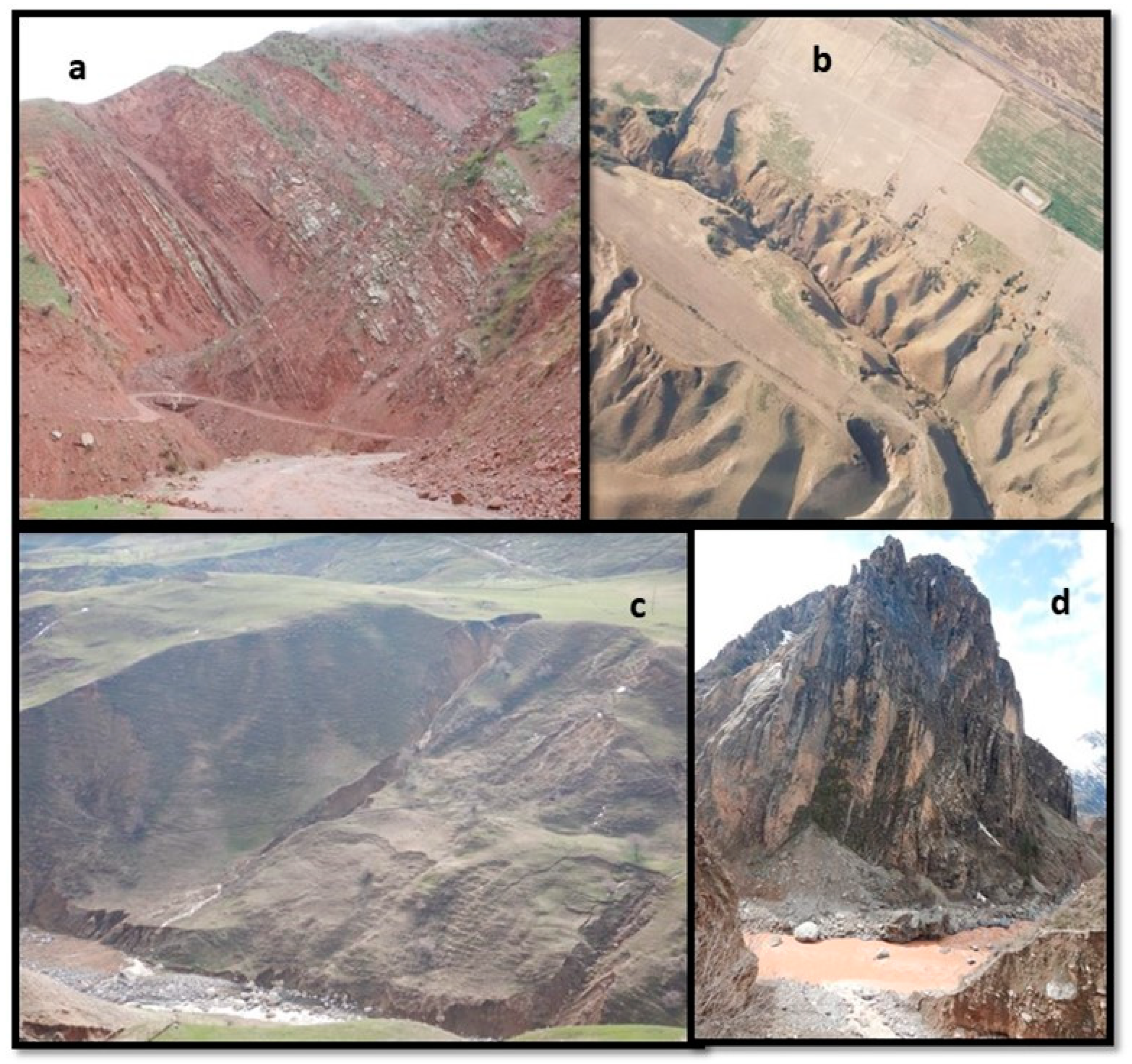
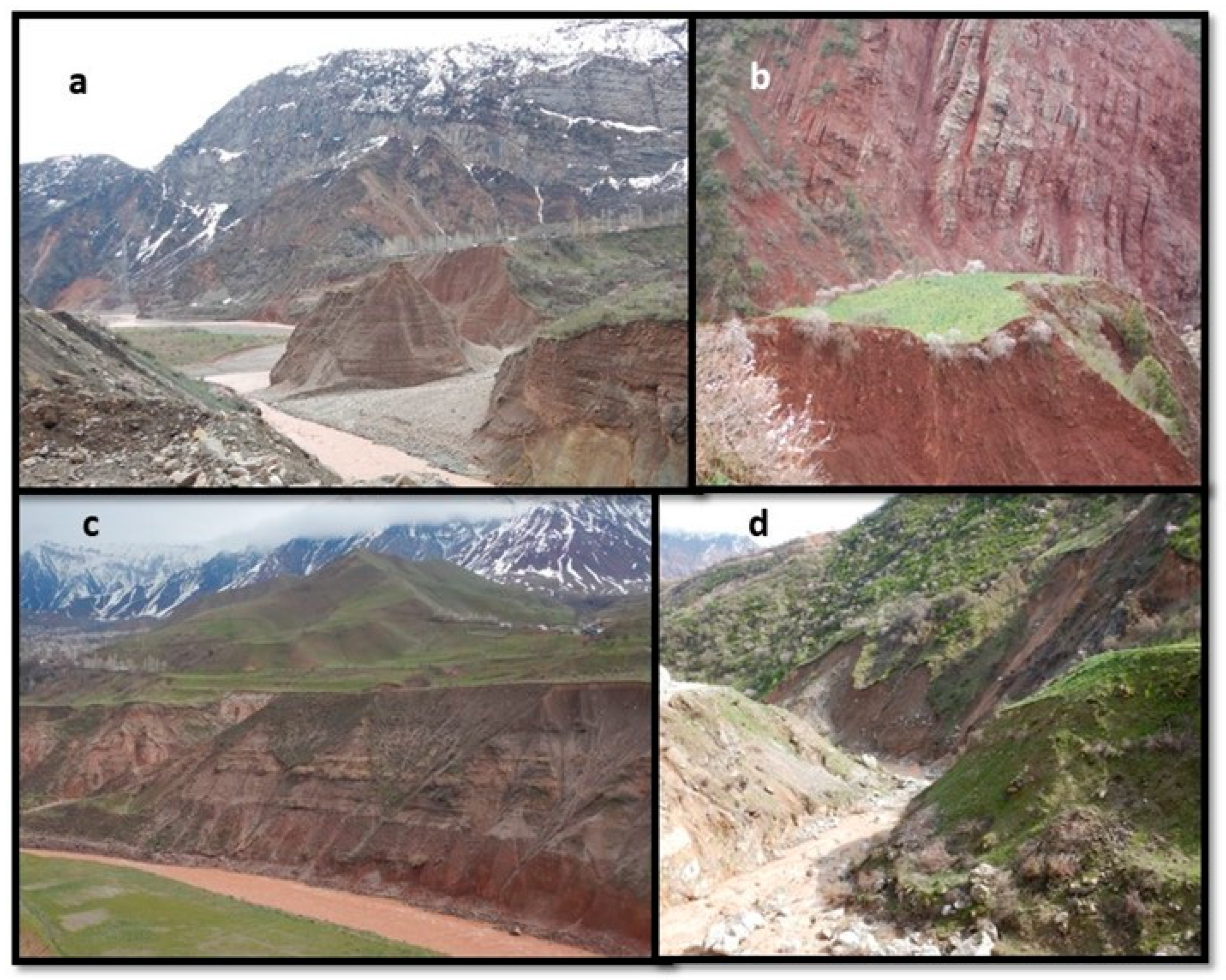
4.2.2. Mass Wasting Processes Affecting Sedimentation

Mass erosion, particularly landslides and debris flows, are the major sediment contributors to the Vakhsh River. While these episodic processes are confined to more specific sites compared to the more chronic surface erosion processes, when they occur, they frequently deposit huge volumes of sediment into channels or along channel margins that becomes entrained during high flows, and some of the deeper landslides progressively feed sediment into the fluvial system.
Like other high elevation areas of Central Asia, the mechanisms for initiation of mass movements within the mountainous portions of the Vakhsh basin are diverse. Along moderately steep slopes that flank the river and larger tributaries, deep-seated landslides; shallow, rapid landslides; and slope sags occur, constituting complex arrays of inner-gorge landslides (Figure 4a). Deep-seated landslides typically respond to an accumulation of rainfall or snowmelt over several weeks, but sometimes may activate more rapidly (#2 and #3 in Figure 4a). We observed deep-seated failures mostly in moderately steep terrain (≈18–32°). A potential mechanism for reactivating ancient deep landslides is the dissolution of salt within evaporite deposits as well as karst dissolution along the toe of slopes, a particular concern around the reservoirs [45]. Climate-related reactivation of ancient landslides may also contribute huge, spatially discrete volumes of sediment to the Vakhsh River. Recent remote-sensing evidence suggests an association between seismic activity in the basin and the activation of large, slow-moving slope failures [56].
Shallow, rapid landslides occur during individual storms or at peak snowmelt [57] (#1 in Figure 4a). These slope failures are typically smaller than deep-seated landslides and occur on steeper slopes (≈30–42°). Slopes > 42° do not support significant soil mantles, and rock failures and dry ravel are the dominant mass wasting processes in these steep areas. Bank failures of various sizes, common in soft sediments along channels, initiate during high flows that undercut streambanks (#6 in Figure 4a). Progressive slope sagging occurs in silty materials (#4 in Figure 4a) and is a continuous supply of sediment directly to streams or to unstable terrain features. Retrogressive slope failures are also common in these loess sediments, expanding previous landslides (#5 in Figure 4a).
While most of the landslides in the basin initiate during snowmelt or rainfall, earthquakes may occasionally trigger slope failures, particularly large magnitude (M > 6) earthquakes with shallow focal depths (<15 km). Clusters of recent minor seismic activity (M < 4) have occurred in the mid-basin (south of Gharm) and the upper basin [58]. In recent decades, only two large (M > 7) earthquakes (1974 and 1984) occurred near the Vakhsh basin, proximate to the Chinese–Kyrgyz border just east of the Vakhsh basin. Another smaller earthquake (M = 6.7) occurred nearby in the Trans-Alay range [59]. The only other large earthquake in the basin during the past century was the 1949 Khait earthquake (M = 7.6), located about 50 km northeast of Gharm [58]. Although recent seismic activity in the basin appears to mostly initiate small landslides and rockfall along unstable cutslopes, contemporary seismicity has been implicated in the activation of large, slow-moving landslides and rock failures as noted [56]. Small earthquakes could also disrupt steep, rocky slopes, making them more susceptible to future failure.
Debris flows are numerous in steep terrain of the Vakhsh basin, particularly along the rocky hillslopes of tributary channels (Figure 4b). Individual debris flows are typically not large, but their widespread occurrence and runout distance makes them major sediment contributors to the fluvial system. Debris flows often connect directly to streams due to the steep hillslopes and the liquified failure mass. They initiate following an accumulation of coarse sediments in steep ephemeral channels or hillslope interfluves [60]. Once an unstable mass of material has accumulated, failure is triggered by rainfall, snowmelt, or even by gravity, though only if sufficient materials accumulate. These failed sites then infill via rockfall and dry ravel during periods of freeze/thaw and wetting/drying, facilitating repetitive mass wasting in these sites [60,61]. Debris flows are also triggered by the melting of permafrost, particularly around the terminal moraine of glaciers during warm periods. If debris flows deposit in valley bottoms without progressing entirely into streams, debris fans form. Another type of debris flow, caused by mobilization of coarse sediment in relatively gently sloping channels, also occurs in the area (Figure 4a).
Dry ravel and rockfall are very active mass wasting processes in the Vakhsh basin. Dry ravel is the surficial process of soil and coarse fragments moving downslope due to gravity, initiated by freezing and thawing and wetting and drying [62]. This pervasive process occurs on steep slopes with bare soil or exposed weathered regoliths. Dry ravel contributes to the infilling of landslide and debris flow scars in steep terrain [61,62]. Because downslope movement depends on gravity, slopes with gradients steeper than the internal angle of friction of soil or coarse fragments are most prone to dry ravel; in the Vakhsh basin, slopes > 36° are most vulnerable, e.g., steep exposed inner gorges and stream banks (Figure 5a).
Rockfall is widespread throughout the steep exposed slopes in the basin, exacerbated by highly fractured and folded bedrock (Figure 5b). While rockfall may not immediately contribute to sediment transport in streams, rocks deposited in headwater channels can easily be fragmented during debris flows or floods and augment coarse sediment (bedload) transport. Rockfall occurs along excavated hillslopes, such as road corridors (Figure 5c), and is most active during periods of rainfall, snowmelt, active freezing and thawing, extreme temperature changes, and during earthquakes.
Solifluction is a surficial mass movement that exists in alpine areas above ≈4000 m in the Pamir-Alay. During summer melting of the active layer above the permafrost, the soil begins to deform (Figure 5d). Given the remoteness of many of these areas, solifluction is likely not a significant contributor of sediment to the Vakhsh River. However, climate warming has gradually increased the rate of permafrost melting in high elevation areas and has the potential to enhance and accelerate solifluction [63] and initiate landslides when permafrost occurs in steep terrain.

4.2.3. Glacial Sedimentation Processes

The numerous high elevation glaciers in the Pamir-Alay release large quantities of sediment in the silt to fine sand size range. Many of the tributaries in the eastern Vakhsh basin are fed by glacial melt. Glacial sediments are easily transported by water and evidence of transient, gray-colored glacial sediment deposits exist along the margins of the Vakhsh River. Some of the glaciers in the basin contain small lakes, which have the potential to discharge rapidly as glacial lake outburst floods (GLOFs) when glaciers melt in a warming climate. In addition to being very hazardous, GLOFs transport huge quantities of sediment downstream and can even dam channels. Debris flows attributed to permafrost melting around the terminal moraine of glaciers have been reported in the nearby Pamir [64]. The release of sediment from gradual glacial melt is more chronic compared to the spatially discrete and episodic releases of sediment during GLOFs and debris flows associated with warming and permafrost thaw.

4.2.4. Fluvial Erosion Processes

Flow regime in ephemeral channels, tributaries, and the main stem of the Vakhsh River is a determining geomorphic agent for sediment detachment and transport. In steep ephemeral channels, rapid snowmelt or episodic rainfall generates flash floods that may widen and evacuate stored sediment in these steep channels. These processes occur as debris flows, hyperconcentrated flows, or floods, transporting high sediment loads. The widening and deepening of these steep channels within soft valley fills are common occurrences in this young mountainous terrain. These constantly evolving fluvial systems with frequent mass wasting inputs, high sediment loads, and eroding banks coupled with lack of or degraded riparian vegetation are not conducive to productive aquatic habitat [65].
In perennial mountain tributaries, high-energy stormflow or meltwater erodes banks and channel features, entraining large quantities of sediment. Many of these tributaries have incised in soft colluvial, alluvial, and glacial fill materials; thus, fluvial adjustment is occurring in these youthful systems. We observed shifting channels that created isolated islands that were continuously eroding (Figure 6a). Ephemeral channels and large gullies cutting through soft sediment to reach perennial tributaries also create remnant islands that are rapidly disappearing (Figure 6b).
Streambank erosion is an important and sometimes overlooked component of catchment sediment budgets [66]. Many of the tributaries, as well as the main stem of the Vakhsh River, are incised in soft depositional materials and contribute substantial sediment to the fluvial system via bank erosion. The main channel of the river is incised through terrace deposits, revealing a sequence of past sedimentation episodes that reflect historic floods and previous episodic debris flows, hyperconcentrated flows, or GLOFs (Figure 6c). These steep channel sides easily erode during high flows; once undercut, streambank failures occur. In tributaries cutting through valley fill, deep sequences of sedimentary deposits are exposed along streambanks, creating opportunities for extensive erosion during peak runoff periods and facilitating the undercutting of streambanks that promote mass wasting of exposed sediment sequences (Figure 6d).
Assessing the extent of streambank erosion at the catchment scale is difficult. The most promising approaches employ a time series of high-resolution remote sensing images where erosion ‘hot spots’ are assessed using multi-temporal terrestrial laser scanning to reconstruct high-resolution, 3D models of riverbank changes [67]. Such quantification of streambank erosion inputs to the overall sediment budget of the Vakhsh basin have not been conducted. Excavations and disturbances in and around the expanded Rogun Dam construction site also expose large areas of stream or reservoir banks to erosive forces, which contribute sediment.

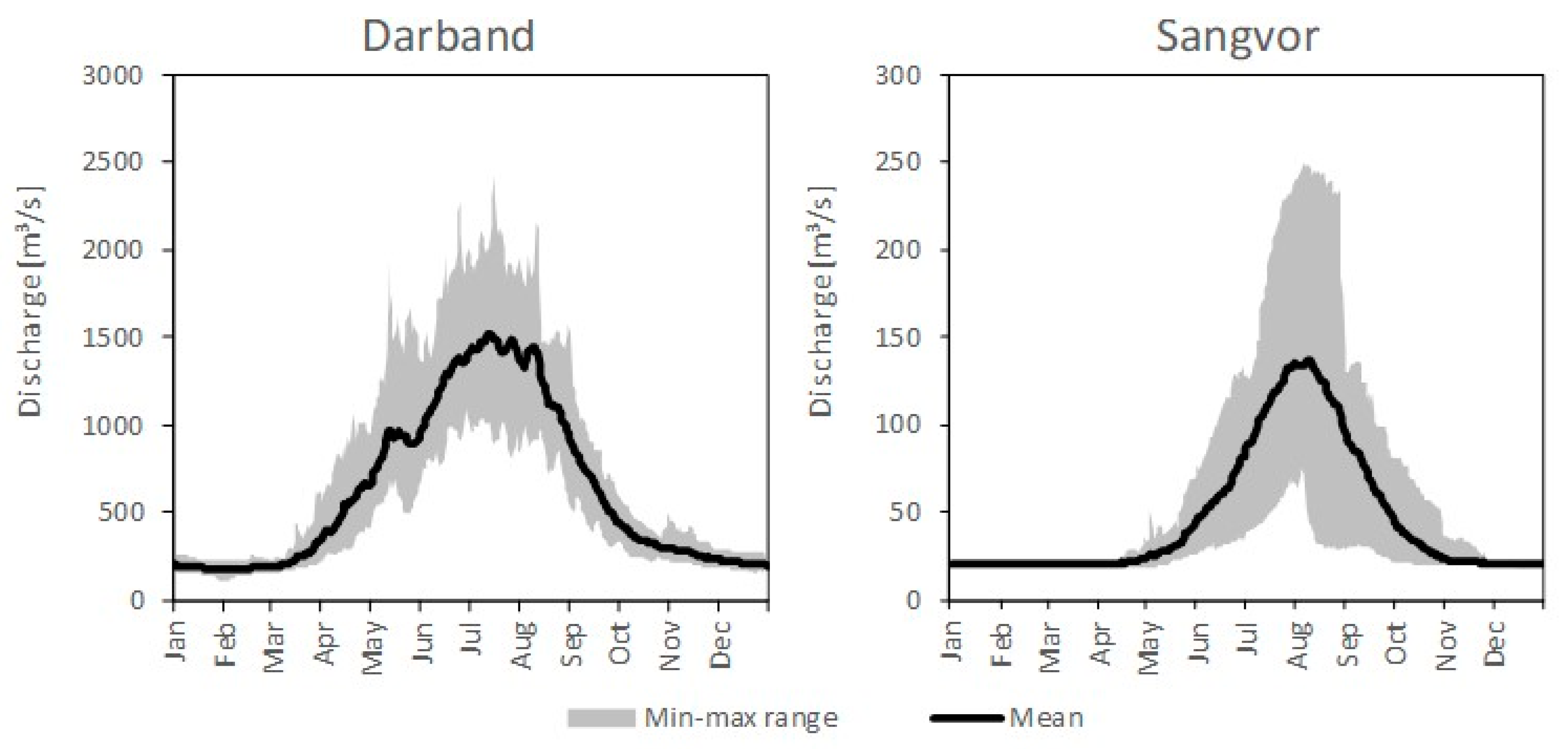
4.3. Vakhsh River Discharge and Suspended Particle Matter Transport

Discharge records for the few gaging stations in the Vakhsh basin are plagued with gaps, errors in the rating curves, challenges in monitoring cross-sections, and short records. Notably, no multi-year discharge data are available in the eastern basin and no data exist in small basins. Here, we show mean discharge data from five of the more reliable stations, which had no data gaps exceeding 1 year or major anomalies in the rating curves, with basin areas ranging from 1161 km2 (Khait) to 28,874 km2 (Darband) and record lengths ranging from 8 years (Khait and Gharm) to 20 years (Darband) (Table 1).
Evidence of increasing discharge in the Surkhob and Obikhingob rivers, tributary to the Vakhsh, has been noted since the late 1980s [68], which agrees with the increases in precipitation we documented (see Section 4.4). In all years, peak runoff at the five gaging stations occurred from late spring through summer during the melt period. Two of the longer and somewhat more reliable flow records are at Darband, located upstream of the Rogun Dam on the Vakhsh River, and at Sangvor, on the Obikhingob River. The discharge time series of these two stations were analyzed in detail by computing daily regime curves (mapping all years of daily discharge records onto one 365-day calendar year) and calculating the average daily discharge (Figure 7). Discharge at Darband is more variable than at Sangvor, with the former exhibiting a weak tendency of a bimodal peak where the first peak likely originates from snowmelt/rain and the latter is attributed to glacier melt. The gaging station at Sangvor (≈2200 m a.s.l.) captures runoff from high-elevation mountainous areas of the southcentral basin, with significant contributions from snow and glacier melt and unknown quantities of permafrost thaw. The broader hydrograph peak at Darband, due to the larger catchment and more diverse runoff inputs, is centered in late July, about one month earlier than the sharper peak discharge at Sangvor (Figure 7). These discharge values obtained from Tajik Hydromet seem high compared to our precipitation estimates in the region, but IMERG could be underestimating precipitation.
During eight field campaigns from late March to mid-August in 2020, grab samples were collected for suspended particle matter (SPM) assessment at five locations of the Vakhsh River, starting at Gharm hydropost and working downstream to below the Nurek Dam. Most samples revealed a dramatic decrease in SPM in the downstream direction, with the highest concentrations in July and August (Figure 8). The lowest concentrations occurred in the first two sampling periods (late March and mid-May), as well as in the early July sample. The lower concentrations above the dams in late spring likely reflect sampling that occurred prior to the major snowmelt, but the low concentrations in early July could reflect the period between snowmelt-derived sediment and the glacial runoff peak (Figure 8). SPM concentrations at the Gharm hydropost were 4588 mg/L in mid-June and 6180 mg/L in mid-August, likely representing the approximate peak of snowmelt and glacial melt runoff, respectively. The dramatic decrease in SPM downriver from the dams highlights the ongoing concerns of sedimentation in these reservoirs [42]. While these SPM trends show the overall dominance of the hydrological driver of sedimentation at different times, we cannot directly link these transported sediments to specific sources.

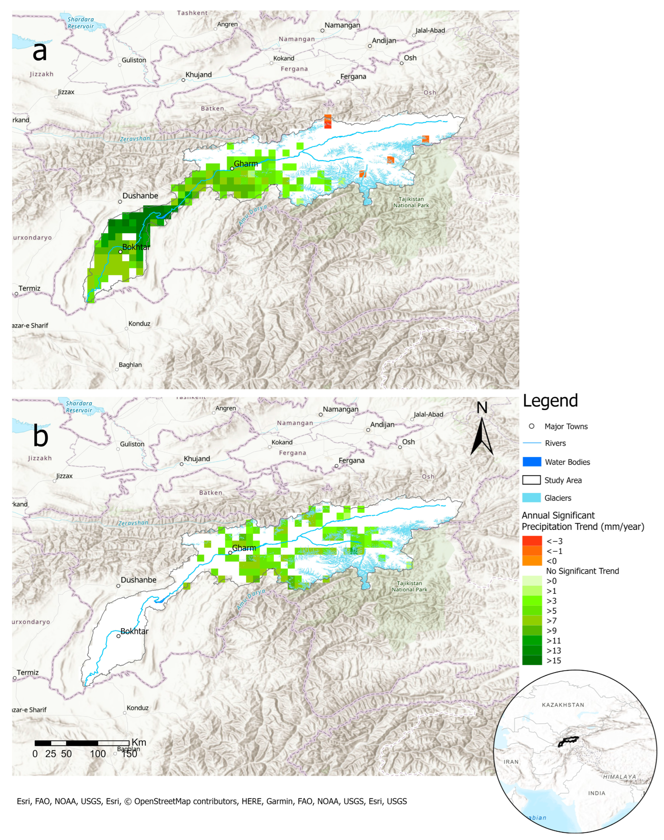
4.4. Effects of Climate Trends across the Vakhsh Basin on Sedimentation

Based on IMERG remote sensing data from 2000 to 2020, annual trends of total and liquid precipitation increased significantly throughout the combined Vakhsh basin. Increases in rainfall occurred in the lower-to-middle portion of the basin (Figure 9a), while increases in total precipitation extended further east. Average total precipitation across the basin during the 20-year period was 424 mm, with about 45% occurring as rainfall. While solid precipitation (snow water equivalent) did not exhibit an overall significant annual increase in the basin, significant increases occurred in widespread areas of the mid-east basin (Figure 9b).
Examining monthly precipitation trends provides insights into the flow and sediment regime of the Vakhsh fluvial system. For rainfall, increases largely occurred from March in the lower basin, shifting progressively up into the mid-basin through June (Figure 10a,b). These increases, while providing early season water supplies for agriculture and reservoirs, may exacerbate sediment contributions associated with mass wasting and surface erosion, particularly in the lower-to-mid-basin. High sediment loads in late May and mid-June occurred in our sampling transect (Figure 8) but were complicated by late summer glacial contributions. From July through October, only a few pixels of both increases and decreases in rainfall were recorded; thus, sediment fluxes are likely not increasing from surface or mass erosion during this period, but agricultural droughts can persist.
Aside from scattered increases in monthly solid precipitation from April through June over glacial terrain in the southeastern basin and a small cluster of increases in February in the northeast, the largest increasing trend occurred in March when much of the eastern and particularly the central portions of the basin experienced major snow water increases (Figure 11). Decreasing trends in solid precipitation were evident only in narrow areas of the northeast and southeast basin in December and in very scattered east-to-mid-basin areas in October. The March increases in solid precipitation over glaciated regions (Figure 11) will likely help compensate for glacier mass lost due to warming temperatures, but the effects on summer runoff and sediment from glaciers could increase, as evidenced by the high sediment concentrations measured at Gharm (Figure 8).

4.5. Land Use–Land Cover in the Vakhsh Basin

Of the 19 land cover classes identified from Sentinel images, grasslands, bare areas, and crop lands constituted 33%, 17%, and 21% of the total catchment area. Permanent snow and ice cover, including the many glaciers, occupied 11.8% of the basin at high elevations in the southeast portion of the basin (Figure 12). Most of the cropland is concentrated in the lower-elevation, less hilly western portion of the basin where rainfall has increased during the past 20 years. Depending on the timing and intensity of spring storms, these increases could exacerbate gully erosion in the loess soils of this agricultural region.
Many of the grasslands throughout the basin have been heavily overgrazed, degrading the pasture habitat by introducing unpalatable species [69]. This, coupled with increasing temperatures in the mid-to-upper basin, may increase both surficial and gully erosion. Compaction from cattle trampling, together with concentrated runoff from roads and cultivated lands, creates pathways for channelized overland flow during storms, initiating gully erosion and headcutting existing gullies [48]. Because livestock tend to congregate around streams and wet areas where vegetation is lush, these hydrological impacts become more pronounced. Heavy grazing in these wetter areas has depleted woody vegetation, thereby reducing the root reinforcement that enhances streambank stability [62]. Small terraces created by livestock traversing hillslopes are evident throughout many degraded areas in the basin (Figure 13a). These terraces may facilitate the ingress of rainfall and snowmelt, which in turn can initiate shallow landslides or slope sagging [62]. The widespread poor land cover and soil compaction contributes to the high sediment concentrations observed in the mid-Vakhsh reaches during late spring to early summer rains (Figure 8). While it is evident that only scattered forests exist in the basin (Figure 12 and Figure 13b), it is unclear how much of the basin was in forest cover a century ago. Speculation about how much of the forest cover has been cleared abounds [70], with little quantitative evidence to support this decline.
Cultivated agriculture and orchards in flatter regions located far from channels likely contribute little sediment to the fluvial system, but if connected via gullies or other overland flow paths, these areas become effective sources and conduits of fluvial sediment (Figure 13c). In steeper areas, farms are typically small and, even if not optimally managed, tend to only contribute minor amounts of fluvial sediment.
Roads and trails, especially when cut into steep, unstable hillslopes, contribute the most mass wasting sediment per unit of affected area of any land use due to undercutting, concentrating drainage, and overloading fillslopes [62]. While the road network in the Vakhsh basin is not dense, many unimproved and poorly planned roads and trails follow tributaries in the mountainous terrain, providing efficient conduits of sediment to the fluvial system. As previously noted, road cuts also greatly enhance rockfall (Figure 5c). These slope failures not only supply sediment to streams, but also occasionally kill or injure travelers and impact downslope property [64]. Surface erosion from roads and trails also supplies considerable sediment to streams. These fine sediments are entrained during snowmelt or rain events and can rapidly reach the fluvial system. Because little attention is paid to proper location and construction of mountain roads in the Pamir-Alay Range, high rates of many types of mass failures occur along these corridors (Figure 4c and Figure 13d).

5. Conclusions

Clearly, high sediment loads transported into the Vakhsh River and its tributaries constitute major concerns for the downstream hydropower plants, as well as irrigation and community water supplies. Furthermore, the major sources of both surface and mass erosion that supply these sediments to the fluvial system represent land degradation challenges in some cases. However, the natural sources of sediment to the fluvial system (e.g., incision in glacial valley fills, mass wasting along steep streambanks) appear to dominate over anthropogenically affected sediment. The distribution of the major sediment sources within the basin determines how connected these are to the fluvial system and the timing of their release related to rain and snowmelt events and glacial melt.
Our observations in middle-to-high elevations of the Vakhsh basin show that mass wasting processes dominate sediment inputs to tributaries of the Vakhsh River. While finer sediments related to this mass wasting are transported downstream, coarser materials and sediment deposited along the fringes of the active channels may be mobilized much later, following weathering and high peak flows (Figure 2c,d). Another major and somewhat direct source of sediment in these mid-to-high-elevation tributaries involves fluvial dynamics, where channels cut through deep glacial valley deposits, leaving remnant ‘islands’ of rapidly eroding materials (Figure 6a,b). In contrast, soil erosion in more gently sloping soft deposits (e.g., gullies and bank erosion in loess) at lower elevations deliver fine sediment to the river during rainfall and snowmelt (Figure 2b and Figure 13c). In the highest elevations of the Vakhsh, glacial melt contributes a significant source of easily transported, silt-sized gray sediment to the fluvial system. These observations throughout the Vakhsh basin reveal the complexity of interpretating the spatial-temporal patterns of SPM in the main stem of the Vakhsh River (Figure 8).
Opportunities to significantly reduce anthropogenically derived sediment need to focus on grazing and agricultural management along with location and construction of roads and trails. Examples of pastoral practices that can reduce sedimentation in this area include rotational grazing, pasture improvement measures, removal of unpalatable species, and diversion of watering points away from channels [48,69]. Shifting from commonly used flood irrigation [71] to more water-efficient systems will reduce gully erosion [48]. Using limited-till cultivation and cultivating along slope contours with vegetated buffers will reduce sediment connectivity to waterways [31]. Planting locally adapted vegetation can also reduce soil erosion as well as irrigation requirements [72]. The most beneficial conservation practices are those located near channels that disconnect sediment supplies from the fluvial system.
Climate trends during the last couple decades have shown a pattern of increasing rainfall in the mid-to-lower basin, particularly from spring to early summer, while solid precipitation has increased in the eastern half of the basin, mostly in March; these trends support the higher discharge noted in two major tributaries to the Vakhsh during the past four decades [68]. If these short-term (20-year) increasing precipitation trends continue, this would produce more spring and early summer runoff with concomitant increases in erosion and sedimentation at times when vegetation is just emerging. The increases in water supplies, however, are beneficial for hydropower production and agriculture. As such, recent focus has been placed on how sediment supplies can be reduced in this erodible terrain [42]. This question begs an assessment of the significance of the various sediment sources, their connectivity to the fluvial system, and whether they are of natural or anthropogenically modified sources.
In the absence of evidence of the distributed nature and extent of various sediment sources and climate forcing, it is speculative to predict sediment delivery to streams, particularly in future climates. For example, while reactivation of ancient landslides may contribute huge, spatially discrete volumes of sediment to the river, the highly uncertain precipitation projections from recent climate modelling studies in this mountainous region [50] offer no insights into future trends related to the possible activation or deactivation of these large failures. Another major limitation is the lack of spatially distributed, robust, and long-term discharge and climate data. As such, we used IMERG remotely sensed data to assess spatially and temporally distributed precipitation trends, recognizing the approximate nature of this surrogate. Most of the hydrological modelling conducted throughout mountainous Central Asia has been forced to rely heavily on coarse global data sets, remote sensing, and climate models [73] or use simple empirical models [74] without the benefit of distributed field data. As such, distributed sediment modelling within these catchments has been conspicuously lacking. While sediment fingerprinting is a useful method to identify relative source contributions assuming unique ‘signatures’ exist [75], the locations, connectivity, and timing of these sources are also needed.
Herein, we present one of the most comprehensive assessments of sediment sources, both natural and anthropogenic, and their connection to the fluvial systems within the little-investigated Vakhsh basin. While much of the information presented is based on observations, this is a first major step to ensure that future sediment estimates in the fluvial system focus on sediment sources and connectivity. Given the numerous hydropower plants along the lower Vakhsh River and the downriver dependence on this water for irrigation and community use, our findings are indeed relevant.

Author Contributions

Conceptualization, R.C.S., B.J. and A.C.; methodology, Z.K., J.K. and M.K.; formal analysis, Z.K., J.K., A.Q. and A.C.; field investigation, B.J., R.C.S., A.C. and Z.K.; funding and resources, B.J., R.C.S. and J.K.; data analysis, Z.K., A.C., R.C.S. and J.K.; writing—original draft preparation, R.C.S.; writing—review and editing, R.C.S., A.C., J.K., M.K. and A.Q.; project administration, R.C.S. and B.J. All authors have read and agreed to the published version of the manuscript.

Funding

This research was partially funded by several sources: World Bank as part of the project “Valuing Green Infrastructure: A Case Study of the Vakhsh River Basin, Tajikistan”; German Academic Exchange Service (DAAD) as part of the SDDnexus Network project “Higher Education Excellence in Development Cooperation–Exceed”; and USAID as part of the project “Climate impacts on the water-food-energy nexus due to changing high mountain hydrology in Tajikistan”.

Data Availability Statement

Requests for data can be made to R.C.S., A.C. or J.K. depending on the required data. Some of the discharge data is restricted.

Acknowledgments

The Tajikistan Agency for Hydrometeorology (Tajik Hydromet) provided the discharge data for the five river gaging stations as part of the World Bank project. Among others who contributed to the field work, we thank Muslim Bandishoev, a former MSRI researcher, as well as Elnura Omurbekova for her excellent administrative support.

Conflicts of Interest

The authors declare no conflicts of interest. J.K. was employed by HYDROC GmbH during his part of this study. The remaining authors declare that the research was conducted in the absence of any commercial or financial relationships that could be construed as a potential conflict of interest. The funders had no role in the design of the study; in the collection, analyses, or interpretation of data; in the writing of the manuscript; or in the decision to publish the results.

References

  1. Baker, L.A. Introduction to nonpoint source pollution in the United States and prospects for wetland use. Ecol. Eng. 1992, 1, 1–26. [Google Scholar] [CrossRef]
  2. Sharpley, A.; Jarvie, H.P.; Buda, A.; May, L.; Spears, B.; Kleinman, P. Phosphorus legacy: Overcoming the effects of past management practices to mitigate future water quality impairment. J. Environ. Qual. 2013, 42, 1308–1326. [Google Scholar] [CrossRef] [PubMed]
  3. Sidle, R.C.; Chambers, J.C.; Amacher, M.C. Fate of heavy metals in an abandoned lead-zinc tailings pond: II. Sediment. J. Environ. Qual. 1991, 20, 752–758. [Google Scholar] [CrossRef]
  4. Islam, M.S.; Ahmed, M.K.; Raknuzzaman, M.; Habibullah-Al-Mamun, M.; Islam, M.K. Heavy metal pollution in surface water and sediment: A preliminary assessment of an urban river in a developing country. Ecol. Indicat. 2015, 48, 282–291. [Google Scholar] [CrossRef]
  5. Kašanin-Grubin, M.; Gajić, V.; Veselinović, G.; Stojadinović, S.; Antić, N.; Štrbac, S. Provenance and pollution status of river sediments in the Danube watershed in Serbia. Water 2023, 15, 3406. [Google Scholar] [CrossRef]
  6. Kile, D.E.; Chiou, C.T.; Zhou, H.; Li, H.; Xu, O. Partition of nonpolar organic pollutants from water to soil and sediment organic matters. Environ. Sci. Technol. 1995, 29, 1401–1406. [Google Scholar] [CrossRef]
  7. Barber, D.S.; Yuldashev, B.S.; Kadyrzhanov, K.K.; Yeleukenov, D.; Ben Ouagrahm, S.; Solodukhin, V.P.; Salikbaev, U.S.; Kist, A.A.; Vasiliev, I.A.; Dzhuraev, A.A.; et al. Radio-ecological situation in river basins of Central Asia Syrdarya and Amudarya according to the results of the project “Navruz”. In Environmental Protection Against Radioactive Pollution; Springer: Dordrecht, The Netherlands, 2003; pp. 39–51. [Google Scholar]
  8. Bradshaw, J.K.; Snyder, B.J.; Oladeinde, A.; Spidle, D.; Berrang, M.E.; Meinersmann, R.J.; Oakley, B.; Sidle, R.C.; Sullivan, K.; Molina, M. Characterizing relationships among fecal indicator bacteria, microbial source tracking markers, and associated waterborne pathogen occurrence in stream water and sediments in a mixed land use watershed. Water Res. 2016, 101, 498–509. [Google Scholar] [CrossRef]
  9. Pizzuto, J.E. Channel adjustments to changing discharges, Powder River, Montana. Geol. Soc. Am. Bull. 1994, 106, 1494–1501. [Google Scholar] [CrossRef]
  10. Wood, P.J.; Armitage, P.D. Biological effects of fine sediment in the lotic environment. Environ. Manag. 1997, 21, 203–217. [Google Scholar] [CrossRef]
  11. Kondolf, G.M.; Gao, Y.; Annandale, G.W.; Morris, G.L.; Jiang, E.; Zhang, J.; Cao, Y.; Carling, P.; Fu, K.; Guo, Q.; et al. Sustainable sediment management in reservoirs and regulated rivers: Experiences from five continents. Earth’s Future 2014, 2, 256–280. [Google Scholar] [CrossRef]
  12. Padhy, M.K.; Saini, R.P. A review on silt erosion in hydro turbines. Renew. Sustain. Energy Rev. 2008, 12, 1974–1987. [Google Scholar] [CrossRef]
  13. Liébault, F.; Gomez, B.; Page, M.; Marden, M.; Peacock, D.; Richard, D.; Trotter, C.M. Land-use change, sediment production and channel response in upland regions. River Res. Appl. 2005, 21, 739–756. [Google Scholar] [CrossRef]
  14. Sidle, R.C.; Ziegler, A.D.; Negishi, J.N.; Abdul Rahim, N.; Siew, R.; Turkelboom, F. Erosion processes in steep terrain—Truths, myths, and uncertainties related to forest management in Southeast Asia. For. Ecol. Manag. 2006, 224, 199–225. [Google Scholar] [CrossRef]
  15. Korup, O.; Densmore, A.L.; Schlunegger, F. The role of landslides in mountain range evolution. Geomorphology 2010, 120, 77–90. [Google Scholar] [CrossRef]
  16. Ramos-Scharrón, C.E.; MacDonald, L.H. Measurement and prediction of natural and anthropogenic sediment sources, St. John, US Virgin Islands. Catena 2007, 71, 250–266. [Google Scholar] [CrossRef]
  17. Sidle, R.C.; Gomi, T.; Loaiza Usuga, J.C.; Jarihani, B. Hydrogeomorphic processes and scaling issues in the continuum from soil pedons to catchments. Earth-Sci. Rev. 2017, 175, 75–96. [Google Scholar] [CrossRef]
  18. Walling, D.E. The sediment delivery problem. J. Hydrol. 1983, 65, 209–237. [Google Scholar] [CrossRef]
  19. Koiter, A.J.; Owens, P.N.; Petticrew, E.L.; Lobb, D.A. The behavioural characteristics of sediment properties and their implications for sediment fingerprinting as an approach for identifying sediment sources in river basins. Earth-Sci. Rev. 2013, 125, 24–42. [Google Scholar] [CrossRef]
  20. Jordan, P.; Slaymaker, O. Holocene sediment production in Lillooet River basin, British Colombia: A sediment budget approach. Géogr. Phys. Quat. 1991, 45, 45–57. [Google Scholar] [CrossRef]
  21. Manh, N.V.; Dung, N.V.; Hung, N.N.; Merz, B.; Apel, H. Large-scale suspended sediment transport and sediment deposition in the Mekong Delta. Hydrol. Earth Syst. Sci. 2014, 18, 3033–3053. [Google Scholar] [CrossRef]
  22. Wilkinson, S.N.; Dougall, C.; Kinsey-Henderson, A.E.; Searle, R.D.; Ellis, R.J.; Bartley, R. Development of a time-stepping sediment budget model for assessing land use impacts in large river basins. Sci. Total Environ. 2014, 468, 1210–1224. [Google Scholar] [CrossRef] [PubMed]
  23. Wilkinson, B.H.; McElroy, B.J. The impact of humans on continental erosion and sedimentation. Geol. Soc. Am. Bull. 2007, 119, 140–156. [Google Scholar] [CrossRef]
  24. Walling, D.E. Linking land use, erosion and sediment yields in river basins. In Man and River Systems: The Functioning of River Systems at the Basin Scale; Springer: Berlin/Heidelberg, Germany, 1999; pp. 223–240. [Google Scholar]
  25. Parsons, A.J.; Wainwright, J.; Powell, D.M.; Kaduk, J.; Brazier, R.E. A conceptual model for determining soil erosion by water. Earth Surf. Process. Landf. 2004, 29, 1293–1302. [Google Scholar] [CrossRef]
  26. Syvitski, J.P.M.; Vörösmarty, C.J.; Kettner, A.J.; Green, P. Impact of humans on the flux of terrestrial sediment to the global coastal ocean. Science 2005, 308, 376–380. [Google Scholar] [CrossRef] [PubMed]
  27. Ziegler, A.D.; Sidle, R.C.; Phang, V.X.; Wood, S.H.; Tantasirin, C. Bedload transport in SE Asian streams—Uncertainties and implications for reservoir management. Geomorphology 2014, 227, 31–48. [Google Scholar] [CrossRef]
  28. Sidle, R.C. Bed load transport regime of a small forest stream. Water Resour. Res. 1988, 24, 207–218. [Google Scholar] [CrossRef]
  29. International Energy Agency (IEA). Tajikistan 2022, Energy Sector Review; IEA: Paris, France, 2022; 134p. [Google Scholar]
  30. Rakhmatullaev, S.; Huneau, F.; Celle-Jeanton, H.; Le Coustumer, P.; Motelica-Heino, M.; Bakiev, M. Water reservoirs, irrigation and sedimentation in Central Asia: A first-cut assessment for Uzbekistan. Environ. Earth Sci. 2013, 68, 985–998. [Google Scholar] [CrossRef]
  31. Sidle, R.C.; Khan, A.A.; Caiserman, A.; Qadamov, A.; Khojazoda, Z. Food security in high mountains of Central Asia: A broader perspective. BioScience 2023, 73, 347–363. [Google Scholar] [CrossRef]
  32. Immerzeel, W.W.; Bierkens, M.F.P. Asia’s water balance. Nat. Geosci. 2012, 5, 841–842. [Google Scholar] [CrossRef]
  33. Zhao, L.; Wu, Q.; Marchenko, S.S.; Sharkhuu, N. Thermal state of permafrost and active layer in Central Asia during the International Polar Year. Permafr. Periglac. Process. 2010, 21, 198–207. [Google Scholar] [CrossRef]
  34. Lambrecht, A.; Mayer, C.; Bohleber, P.; Aizen, V. High altitude accumulation and preserved climate information in the western Pamir, observations from the Fedchenko Glacier accumulation basin. J. Glaciol. 2020, 66, 219–230. [Google Scholar] [CrossRef]
  35. Kronenberg, M.; van Pelt, W.; Machguth, H.; Fiddes, J.; Hoelzle, M.; Pertziger, F. Long-term firn and mass balance modelling for Abramov Glacier in the data-scarce Pamir Alay. Cryosphere 2022, 16, 5001–5022. [Google Scholar] [CrossRef]
  36. Iwata, S. Mapping features of Fedchenko Glacier, the Pamirs, central Asia from space. Geogr. Stud. 2009, 84, 33–43. [Google Scholar] [CrossRef]
  37. Grin, E. Investigation of Glacial Retreat, Terrace Abandonment, and Catchment-Wide Denudation Rates in the Vakhsh Catchment Tajikistan. Ph.D. Thesis, Universität Tübingen, Tübingen, Germany, 2019. [Google Scholar]
  38. Gulakhmadov, A.; Chen, X.; Gulakhmadov, M.; Kobuliev, Z.; Gulahmadov, N.; Peng, J.; Li, Z.; Liu, T. Evaluation of the CRU TS3. 1, APHRODITE_V1101, and CFSR datasets in assessing water balance components in the upper Vakhsh River basin in Central Asia. Atmosphere 2021, 12, 1334. [Google Scholar] [CrossRef]
  39. Kayumov, A. Glaciers Resources of Tajikistan in Condition of the Climate Change; State Agency for Hydrometeorology of Committee for Environmental Protection under the Government of the Republic of Tajikistan: Dushanbe, Tajikistan, 2010. [Google Scholar]
  40. Leonov, M.G.; Rybin, A.K.; Batalev, V.Y.; Matyukov, V.E.; Shchelochkov, G.G. Tectonic structure and evolution of the Hissar–Alay mountain domain and the Pamirs. Geotectonics 2017, 51, 566–583. [Google Scholar] [CrossRef]
  41. Japan International Cooperation Agency (JICA). Data Collection Survey on the Instalment of Small Hydropower Stations for the Communities of Khatlon Oblast in the Republic of Tajikistan; Final Report; Japan International Cooperation Agency (JICA): Tokyo, Japan, 2012; 52p.
  42. World Bank. Valuing Green Infrastructure: A Case Study of the Vakhsh River Basin, Tajikistan; World Bank: Washington, DC, USA, 2023; 110p. [Google Scholar]
  43. Obu, J.; Westermann, S.; Bartsch, A.; Berdnikov, N.; Christiansen, H.H.; Dashtseren, A.; Delaloye, R.; Elberling, B.; Etzelmüller, B.; Kholodov, A.; et al. Northern Hemisphere permafrost map based on TTOP modelling for 2000–2016 at 1 km2 scale. Earth-Sci. Rev. 2019, 193, 299–316. [Google Scholar] [CrossRef]
  44. Burtman, V.S. Nappes of the southern Tien Shan. Russ. J. Earth Sci. 2008, 10, ES1006. [Google Scholar] [CrossRef]
  45. Techno-Economic Assessment Study (TEAS) Consultants. Techno-Economic Assessment Study for Rogun Hydroelectric Construction Project, Phase II Report (Final); Coynre et Bellier: Gennevilliers, France; ELC Electroconsult: Milan, Italy; IPA Energy + Water Economics: Edinburgh, UK, 2014. [Google Scholar]
  46. Schwab, M.; Ratschbacher, L.; Siebel, W.; McWilliams, M.; Minaev, V.; Lutkov, V.; Chen, F.; Stanek, K.; Nelson, B.; Frisch, W.; et al. Assembly of the Pamirs: Age and origin of magmatic belts from the southern Tien Shan to the southern Pamirs and their relation to Tibet. Tectonics 2004, 23, 1–31. [Google Scholar] [CrossRef]
  47. Forster, T.; Heller, F. Loess deposits from the Tajik depression (Central Asia): Magnetic properties and paleoclimate. Earth Planet. Sci. Lett. 1994, 128, 501–512. [Google Scholar] [CrossRef]
  48. Sidle, R.C.; Jarihani, B.; Kaka, S.I.; Koci, J.; Al-Shaibani, A. Hydrogeomorphic processes affecting dryland gully erosion: Implications for modelling. Prog. Phys. Geogr. Earth Environ. 2019, 43, 46–64. [Google Scholar] [CrossRef]
  49. Cui, Y.; Chen, L.; Li, M.; Men, Z. The study of watershed topography characteristics in Vakhsh River based on ZY3-DSM. Int. Arch. Photogram. Remote Sens. Spat. Inform. Sci. 2018, 42, 245–251. [Google Scholar] [CrossRef]
  50. Gulakhmadov, A.; Chen, X.; Gulahmadov, N.; Liu, T.; Anjum, M.N.; Rizwan, M. Simulation of the potential impacts of projected climate change on streamflow in the Vakhsh river basin in central Asia under CMIP5 RCP scenarios. Water 2020, 12, 1426. [Google Scholar] [CrossRef]
  51. Demidov, V.; Akhmadov, H. Rehabilitation of Saline Soils in Tajikistan: The Example of Saline Soils in Vakhsh Valley; Eurasian Center for Food Security: Moscow, Russia, 2016; Volume 8–9, 14p. [Google Scholar]
  52. Sidle, R.C.; Onda, Y. Hydrogeomorphology: Overview of an emerging science. Hydrol. Process. 2004, 18, 597–602. [Google Scholar] [CrossRef]
  53. Borselli, L.; Cassi, P.; Torri, D. Prolegomena to sediment and flow connectivity in the landscape: A GIS and field numerical assessment. Catena 2008, 75, 268–277. [Google Scholar] [CrossRef]
  54. Bautista, S.; Mayor, Á.G.; Bourakhouadar, J.; Bellot, J. Plant spatial pattern predicts hillslope runoff and erosion in a semiarid Mediterranean landscape. Ecosystems 2007, 10, 987–998. [Google Scholar] [CrossRef]
  55. Rijsdijk, A.; Bruijnzeel, L.A.; Prins, T.M. Sediment yield from gullies, riparian mass wasting and bank erosion in the Upper Konto catchment, East Java, Indonesia. Geomorphol. Hum. Impact Geomorphol. Trop. Mt. Areas 2007, 87, 38–52. [Google Scholar] [CrossRef]
  56. Jones, N.; Manconi, A.; Strom, A. Active landslides in the Rogun Catchment, Tajikistan, and their river damming hazard potential. Landslides 2021, 18, 3599–3613. [Google Scholar] [CrossRef]
  57. Sidle, R.C.; Bogaard, T.A. Dynamic earth system and ecological controls of rainfall-initiated landslides. Earth-Sci. Rev. 2016, 159, 275–291. [Google Scholar] [CrossRef]
  58. Metzger, S.; Ischuk, A.; Deng, Z.; Ratschbacher, L.; Perry, M.; Kufner, S.K.; Bendick, R.; Moreno, M. Dense GNSS profiles across the northwestern tip of the India-Asia collision zone: Triggered slip and westward flow of the Peter the First Range, Pamir, into the Tajik Depression. Tectonics 2020, 39, e2019TC005797. [Google Scholar] [CrossRef]
  59. Qiao, X.; Wang, Q.; Yang, S.; Li, J.; Zou, R.; Ding, K. The 2008 Nura Mw6. 7 earthquake: A shallow rupture on the Main Pamir Thrust revealed by GPS and InSAR. Geodesy Geodyn. 2015, 6, 91–100. [Google Scholar] [CrossRef]
  60. Imaizumi, F.; Sidle, R.C.; Tsuchiya, S.; Ohsaka, O. Hydrogeomorphic processes in a steep debris flow initiation zone. Geophy. Res. Lett. 2006, 33, L10404. [Google Scholar] [CrossRef]
  61. Imaizumi, F.; Sidle, R.C.; Togari-Ohta, A.; Shimamura, M. Temporal and spatial variation of infilling processes in a landslide scar in a steep mountainous region, Japan. Earth Surf. Process. Landf. 2015, 40, 642–653. [Google Scholar] [CrossRef]
  62. Sidle, R.C.; Ochiai, H. Landslides: Processes, Prediction, and Land Use; Water Resources Monograph; American Geophysical Union: Washington, DC, USA, 2006; Volume 18, 312p. [Google Scholar]
  63. Biskaborn, B.K.; Smith, S.L.; Noetzli, J.; Matthes, H.; Vieira, G.; Streletskiy, D.A.; Schoeneich, P.; Romanovsky, V.E.; Lewkowicz, A.G.; Abramov, A.; et al. Permafrost is warming at a global scale. Nat. Commun. 2019, 10, 264. [Google Scholar] [CrossRef] [PubMed]
  64. Sidle, R.C. Dark clouds over the Silk Road: Challenges facing mountain environments in Central Asia. Sustainability 2020, 12, 9467. [Google Scholar] [CrossRef]
  65. Wohl, E. Human impacts to mountain streams. Geomorphology 2006, 79, 217–248. [Google Scholar] [CrossRef]
  66. Palmer, J.A.; Schilling, K.E.; Isenhart, T.M.; Schultz, R.C.; Tomer, M.D. Streambank erosion rates and loads within a single watershed: Bridging the gap between temporal and spatial scales. Geomorphology 2014, 209, 66–78. [Google Scholar] [CrossRef]
  67. Longoni, L.; Papini, M.; Brambilla, D.; Barazzetti, L.; Roncoroni, F.; Scaioni, M.; Ivanov, V.I. Monitoring riverbank erosion in mountain catchments using terrestrial laser scanning. Remote Sens. 2016, 8, 241. [Google Scholar] [CrossRef]
  68. Normatov, P.I.; Normatov, I.S. Monitoring of meteorological, hydrological conditions and water quality of the main tributaries of the transboundary Amu Darya river. In Achievements and Challenges of Integrated River Basin Management; IntechOpen: London, UK, 2018; Volume 149. [Google Scholar]
  69. Akhmadov, K.M.; Breckle, S.W.; Breckle, U. Effects of grazing on biodiversity, productivity, and soil erosion of alpine pastures in Tajik Mountains. In Land Use Change and Mountain Biodiversity; CRC: Boca Raton, FL, USA, 2006; pp. 239–247. [Google Scholar]
  70. Mustaeva, N.; Wyes, H.; Mohr, B.; Kayumov, A. Tajikistan: Country Assessment; Working Paper; CAREC (Regional Environmental Central for Central Asia) and PRISE (Pathways to Resilience in Semi-arid Economies): Almaty, Kazakhstan, 2015; 60p. [Google Scholar]
  71. Breu, T.; Hurni, H. Extreme environmental conditions in a breathtaking landscape. In The Tajik Pamirs Challenges of Sustainable Development in an Isolated Mountain Region; Centre for Development and Environment, University of Bern: Bern, Switzerland, 2003; pp. 8–11. [Google Scholar]
  72. Shea, E.C. Adaptative management: The cornerstone of climate-smart agriculture. J. Soil Water Conserv. 2014, 69, 198A–199A. [Google Scholar] [CrossRef]
  73. Pohl, E.; Knoche, M.; Gloaguen, R.; Andermann, C.; Krause, P. Sensitivity analysis and implications for surface processes from a hydrological modelling approach in the Gunt catchment, high Pamir Mountains. Earth Surf. Dynam. 2015, 3, 333–362. [Google Scholar] [CrossRef]
  74. Jalilov, S.M.; Keskinen, M.; Varis, O.; Amer, S.; Ward, F.A. Managing the water–energy–food nexus: Gains and losses from new water development in Amu Darya River Basin. J. Hydrol. 2016, 539, 648–661. [Google Scholar] [CrossRef]
  75. Li, Y.; Gholami, H.; Song, Y.; Fathabadi, A.; Malakooti, H.; Collins, A.L. Source fingerprinting loess deposits in Central Asia using elemental geochemistry with Bayesian and GLUE models. Catena 2020, 194, 104808. [Google Scholar] [CrossRef]
Figure 1. Map of the Vakhsh River basin showing elevation gradients, hydropower plants, and geomorphic features. The five sampling locations for suspended particle matter are shown on the map as Z (Gharm); A (40 m upstream of Rogun Dam); E (downstream of Nurek Dam); F (in Nurek town); and G (beneath Nurek bridge).
Water 16 00122 g001
Figure 2. Lithologic and pedologic sources of sediment to the Vakhsh fluvial system. (a) Uplifted and folded flysch deposits with a small debris flow channel at the road switchback, as well as the rockfall and dry ravel induced along the road cut; (b) gullies in loess deposits of farmlands directly feeding a tributary of the Vakhsh; (c) incised gullies in loess sediments in a terrace deposit and adjacent hillslope; the lower right side shows a heavily grazed sagging slope with an incipient landslide; and (d) rockfall and dry ravel contributing coarse sediment directly to a tributary.
Water 16 00122 g002
Figure 3. (a) Deeply incised gully in soft glacial sediments directly entering a tributary of the Vakhsh; (b) erosional fluting along a steep gully wall; (c) piping erosion along river incised bank; and (d) high sediment loads in a tributary (reddish-brown colored).
Water 16 00122 g003
Figure 4. (a) Different types of landslides in soft sediments of Vakhsh River gorge: 1. shallow, rapid landslides; 2. rapid, deep landslides; 3. slow, deep-seated landslides; 4. slope sagging; 5. retrogressive slope failures; and 6. landslides along streambanks initiated by undercutting. At the mouth of the tributary, there is a debris fan. (b) Debris flows in a steep, incised valley directly contributing sediment to the channel; and (c) landslide along a mountain road caused by overloading the fillslope and runoff concentration.
Water 16 00122 g004
Figure 5. (a) Extensive dry ravel on a bare, steep slope of an inner gorge, contributing continual sediment to the tributary; (b) active rockfall in exposed fractured and folded bedrock slopes; (c) rockfall along a road cut; and (d) active solifluction in the eastern Pamir.
Water 16 00122 g005
Figure 6. (a) Shifting channels in soft sediment sequences creating transitory islands; (b) deep gully incision causing an eroding ‘island’ to form; (c) exposed deep terrace deposits along the Vakhsh River revealing past episodic sediment transport and contemporary bank erosion and failures; and (d) a tributary cutting through soft valley deposits where peak flows undercut valley flanks, causing mass failures and extensive bank erosion.
Water 16 00122 g006
Figure 7. Regime curves of discharge at Darband and Sangvor gaging stations over the complete monitoring periods.
Water 16 00122 g007
Figure 8. Suspended particle matter profiles along the Vakhsh River sampled from spring to late summer, 2020 (sampling locations are shown in Figure 1).
Water 16 00122 g008
Figure 9. Significant trends in annual precipitation (colored pixels) across the Vakhsh basin from 2001 to 2020: (a) liquid precipitation and (b) solid precipitation; non-pixelated regions had no significant change in precipitation.
Water 16 00122 g009
Figure 10. Significant trends in rainfall (colored pixels) from 2001 to 2020: (a) March and (b) June across the Vakhsh basin; non-pixelated regions had no significant change in rain.
Water 16 00122 g010
Figure 11. Significant trends in solid precipitation (colored pixels) from 2001 to 2020 in March across the Vakhsh basin; non-pixelated regions had no significant change in snow water.
Water 16 00122 g011
Figure 12. Map of land cover throughout the Vakhsh catchment.
Water 16 00122 g012
Figure 13. (a) Dense networks of cattle trails forming small terraces along the Vakhsh River; (b) pockets of forest cover along a mountain tributary; (c) pasture and farmland contributing sediment to a tributary during storm runoff via overland flow and linked gullies; and (d) a landslide initiating from road runoff along a fillslope.
Water 16 00122 g013
Table 1. Locations and average discharge from the five most complete and reliable gaging stations in the Vakhsh catchment (data from Tajik HydroMet).
River/TributaryStationLatitudeLongitudeDrainage Area (km2)Average Discharge (m3 s−1)Record Period
VakhshDarband38.683° N69.983° E28,8746202000–2019
VakhshGharm39.000° N70.333° E19,5783582012–2019
SarboghSangimaliki39.033° N70.200° E1772942000–2011
YarkhychKhait39.183° N70.867° E1161492011–2018
ObikhingobSangvor38.783° N71.233° E1881472000–2018
Disclaimer/Publisher’s Note: The statements, opinions and data contained in all publications are solely those of the individual author(s) and contributor(s) and not of MDPI and/or the editor(s). MDPI and/or the editor(s) disclaim responsibility for any injury to people or property resulting from any ideas, methods, instructions or products referred to in the content.

