Estimating Reed Bed Cover in Hungarian Fish Ponds Using NDVI-Based Remote Sensing Technique
Abstract
:1. Introduction
2. Materials and Methods
2.1. Study Area
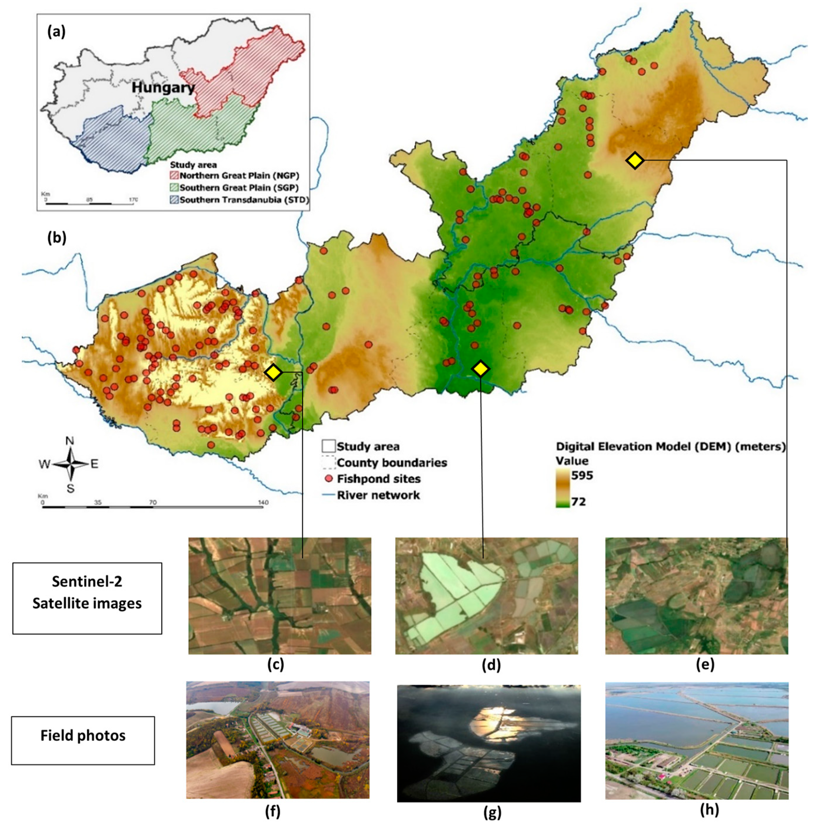
- Barrage ponds (also called watershed ponds), constructed in hilly areas by damming a smaller watercourse, are characteristic of the Transdanubian region. These barrage ponds are supplied with water directly from the natural watercourse and the water availability depends on the precipitation in a smaller catchment area. Therefore, the operation of these Transdanubian ponds is more heavily affected by temporal water scarcity induced by climate change. Barrage ponds are smaller in size and longitudinal in shape, and their depth varies from the point of inflow to the outflow;
- Round-dam ponds (also called embankment ponds) are widely used for fish farming in the Hungarian Great Plain. These excavated ponds are built by removing the soil from the area that will be the pond bottom and building around the pond perimeter. Their water levels are higher than the surrounding areas, and water is deliberately supplied from artificial irrigation channels. Water can be obtained using gravity—if the supply canal is elevated—or by pumping. The availability of water is not limited by the actual rainfall, as these irrigation canals are supplied by larger rivers (the River Tisza and its main tributaries). The ponds have a rectangular shape and are 1–1.2 m deep. Most of Hungary’s fish pond aquaculture takes place in dug-out artificial ponds in the Great Hungarian Plains [33].
2.2. Available Datasets
2.2.1. Reference Datasets
2.2.2. Satellite Data
2.3. Methods
2.4. Accuracy Assessment
3. Results
3.1. Accuracy Assessment of Reed Cover Maps
3.2. Spatial Extent of Reed Cover in Major Fish Production Regions
3.3. Interannual Changes in Reed Cover in Fish Ponds from 2017 to 2021
4. Discussion
4.1. Advantages of Reed Mapping Using NDVI-Based Remote Sensing Technique
4.2. Potential Use in Climate Change Studies
4.3. Uncertainties and Limitations
5. Conclusions
Author Contributions
Funding
Data Availability Statement
Conflicts of Interest
References
- European Market Observatory for Fisheries and Aquaculture Products. The EU Fish Market; Publications Office of the European Union: Luxembourg, 2021. [Google Scholar]
- Bekefi, E.; Varadi, L. Multifunctional Pond Fish Farms in Hungary. Aquac. Int. 2007, 15, 227–233. [Google Scholar] [CrossRef]
- Palásti, P.; Kiss, M.; Gulyás, Á.; Kerepeczki, É. Expert Knowledge and Perceptions about the Ecosystem Services and Natural Values of Hungarian Fishpond Systems. Water 2020, 12, 2144. [Google Scholar] [CrossRef]
- Rejmánková, E. The Role of Macrophytes in Wetland Ecosystems. J. Ecol. Environ. 2011, 34, 333–345. [Google Scholar] [CrossRef]
- Boyd, C.E.; Gross, A. Water Use and Conservation for Inland Aquaculture Ponds. Fish. Manag. Ecol. 2000, 7, 55–63. [Google Scholar] [CrossRef]
- Farrant, D.N.; Frank, K.L.; Larsen, A.E. Reuse and Recycle: Integrating Aquaculture and Agricultural Systems to Increase Production and Reduce Nutrient Pollution. Sci. Total Environ. 2021, 785, 146859. [Google Scholar] [CrossRef] [PubMed]
- Nag, S.K.; Das Ghosh, B.; Nandy, S.; Aftabuddin, M.; Sarkar, U.K.; Das, B.K. Comparative Assessment of Carbon Sequestration Potential of Different Types of Wetlands in Lower Gangetic Basin of West Bengal, India. Environ. Monit. Assess. 2023, 195, 154. [Google Scholar] [CrossRef]
- Kerepeczki, É.; Gál, D.; Kosáros, T.; Hegedűs, R.; Gyalog, G.; Pekár, F. Natural Water Treatment Method for Intensive Aquaculture Effluent Purification. Stud. Univ. Vasile Goldis Ser. Stiintele Vietii 2011, 21, 827–837. [Google Scholar]
- Popp, J.; Békefi, E.; Duleba, S.; Oláh, J. Multifunctionality of Pond Fish Farms in the Opinion of the Farm Managers: The Case of Hungary. Rev. Aquac. 2019, 11, 830–847. [Google Scholar] [CrossRef]
- Turkowski, K.; Lirski, A. Non-Productive Functions of Fish Ponds and Their Possible Economic Evaluation. In Carp Culture in Europe. Current Status, Problems, Perspectives; Lirski, A., Pyć, A., Eds.; IRŚ Olsztyn Pub.: Kazimierz Dolny, Poland, 2011; pp. 25–42. [Google Scholar]
- Francová, K.; Šumberová, K.; Kučerová, A.; Šorf, M.; Grill, S.; Exler, N.; Vrba, J. Drivers of Plant Species Composition of Ecotonal Vegetation in Two Fishpond Management Types. Wetl. Ecol. Manag. 2021, 29, 93–110. [Google Scholar] [CrossRef]
- Francová, K.; Šumberová, K.; Kučerová, A.; Čtvrtlíková, M.; Šorf, M.; Borovec, J.; Drozd, B.; Janauer, G.A.; Vrba, J. Macrophyte Assemblages in Fishponds under Different Fish Farming Management. Aquat. Bot. 2019, 159, 103131. [Google Scholar] [CrossRef]
- Francová, K.; Šumberová, K.; Janauer, G.A.; Adámek, Z. Effects of Fish Farming on Macrophytes in Temperate Carp Ponds. Aquac. Int. 2019, 27, 413–436. [Google Scholar] [CrossRef]
- Gyalog, G.; Berzi-Nagy, L.; Tóth, F.; Békefi, E.; Bojtárné Lukácsik, M. An Analysis of Production Factors in Carp Farming in Hungary (A Hazai Pontyhozamokat Meghatározó Tényezők És a Termelést Korlátozó Erőforrások Elemzése Termelési Függvény Alapján). GAZDÁLKODÁS Sci. J. Agric. Econ. 2021, 65, 130–140. [Google Scholar] [CrossRef]
- Kiss, G. Statisztikai Jelentések. Lehalászás Jelentés 2007–2021 [Statistical Report on Harvest Results in the Aquaculture Sector (2007–2021)]; Agrárközgazdasági Intézet: Budapest, Hungary, 2022. [Google Scholar]
- Hancz, C.; Nagy, Z.; Gál, D.; Varga, D. Issues of Ecological and Economical Sustainability of Fish Culture in the Southern Hydrological Basin of Lake Balaton. Acta Agrar. Kvar. 2015, 19, 25–29. [Google Scholar]
- Dronova, I. Object-Based Image Analysis in Wetland Research: A Review. Remote Sens. 2015, 7, 6380–6413. [Google Scholar] [CrossRef]
- Anderson, C.J.; Heins, D.; Pelletier, K.C.; Bohnen, J.L.; Knight, J.F. Mapping Invasive Phragmites Australis Using Unoccupied Aircraft System Imagery, Canopy Height Models, and Synthetic Aperture Radar. Remote Sens. 2021, 13, 3303. [Google Scholar] [CrossRef]
- Mohler, R.L.; Morse, J.M. Using UAV Imagery to Map Invasive Phragmites Australis on the Crow Island State Game Area, Michigan, USA. Wetl. Ecol. Manag. 2022, 30, 1213–1229. [Google Scholar] [CrossRef]
- Stratoulias, D.; Balzter, H.; Zlinszky, A.; Tóth, V.R. Assessment of Ecophysiology of Lake Shore Reed Vegetation Based on Chlorophyll Fluorescence, Field Spectroscopy and Hyperspectral Airborne Imagery. Remote Sens. Environ. 2015, 157, 72–84. [Google Scholar] [CrossRef]
- Burai, P.; Lövei, G.; Lénárt, C.; Nagy, I.; Enyedi, E. Mapping Aquatic Vegetation of the Rakamaz-Tiszanagyfalui Nagy-Morotva Using Hyperspectral Imagery. AGD Landsc. Environ. 2021, 4, 2010–2011. [Google Scholar]
- Burai, P.; Gaál, M.; Molnár, A.; Bekő, L. Halastavak Vizsgálata Távérzékelési Módszerekkel. In Az Elmélet és a Gyakorlat Találkozása a Térinformatikában X.: Theory Meets Practice in GIS; Molnár, V.É., Ed.; Debrecen University Press: Debrecen, Hungary, 2019. [Google Scholar]
- Tóth, V.R. Monitoring Spatial Variability and Temporal Dynamics of Phragmites Using Unmanned Aerial Vehicles. Front Plant Sci. 2018, 9, 728. [Google Scholar] [CrossRef]
- Petus, C.; Lewis, M.; White, D. Monitoring Temporal Dynamics of Great Artesian Basin Wetland Vegetation, Australia, Using MODIS NDVI. Ecol. Indic. 2013, 34, 41–52. [Google Scholar] [CrossRef]
- Zhao, B.; Yan, Y.; Guo, H.; He, M.; Gu, Y.; Li, B. Monitoring Rapid Vegetation Succession in Estuarine Wetland Using Time Series MODIS-Based Indicators: An Application in the Yangtze River Delta Area. Ecol. Indic. 2009, 9, 346–356. [Google Scholar] [CrossRef]
- Zhao, Y.; Mao, D.; Zhang, D.; Wang, Z.; Du, B.; Yan, H.; Qiu, Z.; Feng, K.; Wang, J.; Jia, M. Mapping Phragmites Australis Aboveground Biomass in the Momoge Wetland Ramsar Site Based on Sentinel-1/2 Images. Remote Sens. 2022, 14, 694. [Google Scholar] [CrossRef]
- Damtew, Y.T.; Verbeiren, B.; Awoke, A.; Triest, L. Satellite Imageries and Field Data of Macrophytes Reveal a Regime Shift of a Tropical Lake (Lake Ziway, Ethiopia). Water 2021, 13, 396. [Google Scholar] [CrossRef]
- Kajári, B.; Bozán, C.; Van Leeuwen, B. Monitoring of Inland Excess Water Inundations Using Machine Learning Algorithms. Land 2023, 12, 36. [Google Scholar] [CrossRef]
- Heung, B.; Ho, H.C.; Zhang, J.; Knudby, A.; Bulmer, C.E.; Schmidt, M.G. An Overview and Comparison of Machine-Learning Techniques for Classification Purposes in Digital Soil Mapping. Geoderma 2016, 265, 62–77. [Google Scholar] [CrossRef]
- Berhane, T.M.; Lane, C.R.; Wu, Q.; Anenkhonov, O.A.; Chepinoga, V.V.; Autrey, B.C.; Liu, H. Comparing Pixel- and Object-Based Approaches in Effectively Classifying Wetland-Dominated Landscapes. Remote Sens. 2018, 10, 46. [Google Scholar] [CrossRef] [PubMed]
- Ayhan, B.; Kwan, C.; Budavari, B.; Kwan, L.; Lu, Y.; Perez, D.; Li, J.; Skarlatos, D.; Vlachos, M. Vegetation Detection Using Deep Learning and Conventional Methods. Remote Sens. 2020, 12, 2502. [Google Scholar] [CrossRef]
- Kiss, G. Statisztikai Jelentések. Lehalászás Jelentés 2021. Év [Harvest Report for the Year 2021]. Available online: http://repo.aki.gov.hu/3943/ (accessed on 7 March 2023).
- Bordós, G.; Urbányi, B.; Micsinai, A.; Kriszt, B.; Palotai, Z.; Szabó, I.; Hantosi, Z.; Szoboszlay, S. Identification of Microplastics in Fish Ponds and Natural Freshwater Environments of the Carpathian Basin, Europe. Chemosphere 2019, 216, 110–116. [Google Scholar] [CrossRef]
- Institute of Agricultural Economics (AKI). Available online: https://www.aki.gov.hu/ (accessed on 7 March 2023).
- Kiss, G. Statisztikai Jelentések. Lehalászás Jelentés 2017. Év [Harvest Report for the Year 2017]. Available online: http://repo.aki.gov.hu/3175/ (accessed on 7 March 2023).
- Kiss, G. Statisztikai Jelentések. Lehalászás Jelentés 2018. Év [Harvest Report for the Year 2018]. Available online: http://repo.aki.gov.hu/3414/ (accessed on 7 March 2023).
- Kiss, G. Statisztikai Jelentések. Lehalászás Jelentés 2019. Év [Harvest Report for the Year 2019]. Available online: http://repo.aki.gov.hu/3584/ (accessed on 7 March 2023).
- Kiss, G. Statisztikai Jelentések. Lehalászás Jelentés 2020. Év [Harvest Report for the Year 2020]. Available online: http://repo.aki.gov.hu/3773/ (accessed on 7 March 2023).
- Kumar, G.; Singh, K.K. Mapping and Monitoring the Selected Wetlands of Punjab, India, Using Geospatial Techniques. J. Indian Soc. Remote Sens. 2020, 48, 615–625. [Google Scholar] [CrossRef]
- Aryal, J.; Sitaula, C.; Aryal, S. NDVI Threshold-Based Urban Green Space Mapping from Sentinel-2A at the Local Governmental Area (LGA) Level of Victoria, Australia. Land 2022, 11, 351. [Google Scholar] [CrossRef]
- Cetin, M.; Isik Pekkan, O.; Bilge Ozturk, G.; Senyel Kurkcuoglu, M.A.; Kucukpehlivan, T.; Cabuk, A. Examination of the Change in the Vegetation Around the Kirka Boron Mine Site by Using Remote Sensing Techniques. Water Air Soil Pollut. 2022, 233, 254. [Google Scholar] [CrossRef]
- Tóth, V.R.; Szabo, K. Morphometric Structural Analysis of Phragmites Australis Stands in Lake Balaton. Ann. Limnol.-Int. J. Limnol. 2012, 48, 241–251. [Google Scholar] [CrossRef]
- Lantz, N. Detection and Mapping of Phragmites Australis Using High Resolution Multispectral and Hyperspectral Satellite Imagery. Master’s Thesis, The University of Western Ontario, London, ON, Canada, 2012. [Google Scholar]
- Abeysinghe, T.; Milas, A.S.; Arend, K.; Hohman, B.; Reil, P.; Gregory, A.; Vázquez-Ortega, A. Mapping Invasive Phragmites Australis in the Old Woman Creek Estuary Using UAV Remote Sensing and Machine Learning Classifiers. Remote Sens. 2019, 11, 1380. [Google Scholar] [CrossRef]
- Xue, J.; Su, B. Significant Remote Sensing Vegetation Indices: A Review of Developments and Applications. J. Sens. 2017, 2017, 1353691. [Google Scholar] [CrossRef]
- Liu, G. Basic Problems and Frontier of Hydrology. Adv. Water Sci. 2020, 31, 685–689. [Google Scholar] [CrossRef]
- Cohen, J. A Coefficient of Agreement for Nominal Scales. Educ. Psychol. Meas. 1960, 20, 37–46. [Google Scholar] [CrossRef]
- Ottinger, M.; Clauss, K.; Kuenzer, C. Opportunities and Challenges for the Estimation of Aquaculture Production Based on Earth Observation Data. Remote Sens. 2018, 10, 1076. [Google Scholar] [CrossRef]
- Rajitha, K.; Mukherjee, C.K.; Vinu Chandran, R. Applications of Remote Sensing and GIS for Sustainable Management of Shrimp Culture in India. Aquac. Eng. 2007, 36, 1–17. [Google Scholar] [CrossRef]
- Khan, R.M.; Salehi, B.; Mahdianpari, M.; Mohammadimanesh, F.; Mountrakis, G.; Quackenbush, L.J. A Meta-Analysis on Harmful Algal Bloom (HAB) Detection and Monitoring: A Remote Sensing Perspective. Remote Sens. 2021, 13, 4347. [Google Scholar] [CrossRef]
- Saitoh, S.I.; Mugo, R.; Radiarta, I.N.; Asaga, S.; Takahashi, F.; Hirawake, T.; Ishikawa, Y.; Awaji, T.; In, T.; Shima, S. Some Operational Uses of Satellite Remote Sensing and Marine GIS for Sustainable Fisheries and Aquaculture. ICES J. Mar. Sci. 2011, 68, 687–695. [Google Scholar] [CrossRef]
- Falconer, L.; Middelboe, A.L.; Kaas, H.; Ross, L.G.; Telfer, T.C. Use of Geographic Information Systems for Aquaculture and Recommendations for Development of Spatial Tools. Rev. Aquac. 2020, 12, 664–677. [Google Scholar] [CrossRef]
- Noi Phan, T.; Kuch, V.; Lehnert, L.W. Land Cover Classification Using Google Earth Engine and Random Forest Classifier—The Role of Image Composition. Remote Sens. 2020, 12, 2411. [Google Scholar] [CrossRef]
- Kirk, J.T.O. Light and Photosynthesis in Aquatic Ecosystems, 2nd ed.; Cambridge University Press: Cambridge, UK, 1994; p. 509. [Google Scholar]
- Zhou, J.; Zhou, W.; Zhou, Q.; Zhu, Y.; Xie, F.; Liang, S.; Hu, Y. The Impact of Multiple Pond Conditions on the Performance of Dike-Pond Extraction. Fishes 2022, 7, 144. [Google Scholar] [CrossRef]


| Year | NUTS-2 Region | Accuracy (OA) | Sensitivity (S) | Precision (P) | Kappa (K) |
|---|---|---|---|---|---|
| 2017 | STD | 0.88 | 0.85 | 0.35 | 0.44 |
| NGP | 0.91 | 0.43 | 0.84 | 0.52 | |
| SGP | 0.93 | 0.92 | 0.76 | 0.80 | |
| 2018 | STD | 0.94 | 0.83 | 0.58 | 0.65 |
| NGP | 0.91 | 0.46 | 0.80 | 0.54 | |
| SGP | 0.92 | 0.86 | 0.73 | 0.75 | |
| 2019 | STD | 0.93 | 0.82 | 0.49 | 0.58 |
| NGP | 0.94 | 0.65 | 0.86 | 0.70 | |
| SGP | 0.87 | 0.70 | 0.91 | 0.70 | |
| 2020 | STD | 0.95 | 0.81 | 0.65 | 0.70 |
| NGP | 0.92 | 0.82 | 0.47 | 0.56 | |
| SGP | 0.95 | 0.79 | 0.89 | 0.80 | |
| 2021 | STD | 0.92 | 0.51 | 0.88 | 0.61 |
| NGP | 0.94 | 0.71 | 0.91 | 0.76 | |
| SGP | 0.92 | 0.78 | 0.96 | 0.80 | |
| Average | STD | 0.92 | 0.76 | 0.65 | 0.60 |
| NGP | 0.92 | 0.81 | 0.85 | 0.77 | |
| SGP | 0.92 | 0.61 | 0.78 | 0.62 |
Disclaimer/Publisher’s Note: The statements, opinions and data contained in all publications are solely those of the individual author(s) and contributor(s) and not of MDPI and/or the editor(s). MDPI and/or the editor(s) disclaim responsibility for any injury to people or property resulting from any ideas, methods, instructions or products referred to in the content. |
© 2023 by the authors. Licensee MDPI, Basel, Switzerland. This article is an open access article distributed under the terms and conditions of the Creative Commons Attribution (CC BY) license (https://creativecommons.org/licenses/by/4.0/).
Share and Cite
Sharma, P.; Varga, M.; Kerezsi, G.; Kajári, B.; Halasi-Kovács, B.; Békefi, E.; Gaál, M.; Gyalog, G. Estimating Reed Bed Cover in Hungarian Fish Ponds Using NDVI-Based Remote Sensing Technique. Water 2023, 15, 1554. https://doi.org/10.3390/w15081554
Sharma P, Varga M, Kerezsi G, Kajári B, Halasi-Kovács B, Békefi E, Gaál M, Gyalog G. Estimating Reed Bed Cover in Hungarian Fish Ponds Using NDVI-Based Remote Sensing Technique. Water. 2023; 15(8):1554. https://doi.org/10.3390/w15081554
Chicago/Turabian StyleSharma, Priya, Monika Varga, György Kerezsi, Balázs Kajári, Béla Halasi-Kovács, Emese Békefi, Márta Gaál, and Gergő Gyalog. 2023. "Estimating Reed Bed Cover in Hungarian Fish Ponds Using NDVI-Based Remote Sensing Technique" Water 15, no. 8: 1554. https://doi.org/10.3390/w15081554
APA StyleSharma, P., Varga, M., Kerezsi, G., Kajári, B., Halasi-Kovács, B., Békefi, E., Gaál, M., & Gyalog, G. (2023). Estimating Reed Bed Cover in Hungarian Fish Ponds Using NDVI-Based Remote Sensing Technique. Water, 15(8), 1554. https://doi.org/10.3390/w15081554


