Article

Study on Water Replacement Characteristics of Xinghai Lake Wetland Based on Landscape Water Quality Objectives

1
National Key Laboratory of Hydraulic Engineering Simulation and Safety, Tianjin University, Tianjin 300350, China
2
Beifang Investigation, Design & Research Co., Ltd., Tianjin 300222, China
*
Author to whom correspondence should be addressed.
Water 2023, 15(7), 1374; https://doi.org/10.3390/w15071374
Submission received: 19 February 2023 / Revised: 30 March 2023 / Accepted: 1 April 2023 / Published: 3 April 2023
(This article belongs to the Topic Hydroelectric Power)

Abstract

:
Many issues with water quality and water ecology are caused by the Xinghai Lake’s enormous catchment, significant evaporation rates, and one additional water supply. To quantitatively study Xinghai Lake’s water displacement characteristics, a two-dimensional hydrodynamic-tracer coupling model based on MIKE21 was developed. The findings indicate that: (1) Xinghai Lake’s water replacement cycle exhibits spatial heterogeneity, with a general characteristic of fast water renewal in the southern lake area and slow renewal in the northern lake area, and the gradient change of the water replacement cycle from south to north is influenced by a variety of factors, including the lake’s flow field, flow, topography, and wind field. (2) The throughput flow has an impact on the majority of the waters in Xinghai Lake. When there is a high water flow, the lake region has a high flow velocity, rapid water transport, and a large capacity for water exchange; when there is a low water flow, the lake area has a slow flow velocity, poor water flow, and a lengthy water exchange period. (3) The flow field of Xinghai Lake is complicated, the flow velocity is low, and it is a lake system where quick water exchange and slow water exchange coexist. This flow field is influenced by the interplay of wind-generated flow and throughput flow. (4) To speed up the water body’s rejuvenation, the Xinghai Lake wetland needs more inlets and exits to introduce new water sources.

1. Introduction

Landscape water bodies are typically found in the city’s center, surrounded by other buildings such as homes and businesses, which have significant value for the city’s ecological environment and economic growth. Urban landscape water bodies, on the other hand, are typically closed, slow-moving, static water bodies that are poorly mobile, easy to pollute, have little water environment capacities, and have poor self-cleaning [1,2]. The conflict between relatively poor environmental management and the growth of the urban population is becoming more and more obvious as urbanization progresses, and numerous urban lakes have experienced varying degrees of pollution. To avoid a decline in lake water quality, regulate pollution, and support the healthy growth of the urban water environment, it is important to clarify the flow field characteristics and water displacement capacity of artificial lakes. Ecological recharge, or the addition of comparatively clean water to polluted water bodies, is a technique for ecosystem restoration [3,4]. It can help the ecology of the water bodies by diluting the contaminants there. Research on hydrodynamics and water displacement characteristics can be used to create practical lake and wetland water environment regulatory policies, enhance lake water quality, and address other issues, including wetland degradation. The scientific basis for safeguarding and reestablishing the biological environment of lakes and wetlands can be found in a thorough understanding of the hydrodynamic and water body exchange features of lakes and the elements that influence them. To preserve the healthy and sustainable operation of the wetland water ecological environment, it is crucial to establish a hydrodynamic-tracer coupling model to realistically conduct recharge scheduling to satisfy the water quality and quantity of lakes and wetlands [5,6]. Jizhang Tang et al. [6] investigated water exchange capacity using the MIKE21 coupled hydrodynamic-staining agent model simulation and discovered that enhancing water exchange capacity is critical to maintaining the health of water ecosystems. Cucco et al. [7] created a two-dimensional hydrodynamic model of the Venice Lagoon to calculate the residence duration of the water column using the residual function of a passive tracer injected into the lagoon. Liping Xu et al. [5] employed computational methods to create hydrodynamic and convective diffusion models to investigate the renewal time and water exchange rate of manmade lakes. Delhezé et al. [8] created a two-dimensional estuary model and a one-dimensional river model to examine convective dispersion in the Skelt River estuary, obtaining the retention, transit, and influence time of estuarine water bodies. The majority of landscape water body research is focused on water quality prediction and water restoration approaches. Qingbin Meng et al. [9] used scenario analysis to simulate Daming Lake’s flow rate and COD distribution under five different water diversion scenarios, in addition to the coupled water quality-quantity simulation method to simulate Daming Lake’s current flow rate and COD distribution. These simulations provided a scientific basis for the reasonable water diversion scheduling of Daming Lake in Jinan City. Wenjie Xu et al. [10] developed a model to determine the optimal water diversion volume of Dongchang Lake after taking into account the water quality and quantity requirements for Dongchang Lake’s main functions, such as landscape tourism and ecological environment. This model served as the foundation for the scientific diversion of water from the Yellow River.
Xinghai Lake is a significant lake in northern Ningxia, China. It has a huge surface area, high evaporation and water consumption in the lake region, and minimal water loss and waste. Since 2004, Xinghai Lake’s primary source of water replenishment has been the Yellow River, due to the lake’s limited capacity for self-purification and reliance on a single source of water recharge. The wetland ecology has a single structure and an unsound system, failing to create a healthy water ecosystem. The ecology is fragile, with low biodiversity and insufficient biological richness of microbes, plants, and fish. There are currently fewer studies on water demand computation and the water replacement cycle from the perspective of the water quality-volume balance of landscape water bodies than there are studies on Xinghai Lake’s evaluation of water environment quality and analysis of pollution sources [11].
Many issues with the water environment and water ecology are caused by the poor mobility of lake water in its natural form, the low frequency of lake water replacement, the lengthy cycle of water replacement, and the declining quality of the lake water environment and water ecology. Welch [12] diverted water from the Columbia River into Moses Lake in 1992 and replaced 20% of the lake’s water, greatly reducing the concentration of pollutants, such as total phosphorus, total nitrogen, and chlorophyll A, in the lake and increasing the lake’s transparency, which made the water in the lake clearer and better. In various European nations, the water quality of polluted water bodies is frequently enhanced by adding clean water from the outside, diluting the pollutants already present in the waters, and then releasing the pollutants from the existing waters by scouring and water transportation. Water environment issues, including eutrophication in the ancient Danube Lake, were extensively managed and improved in 1999 by Donabaum et al. [13], using water diversion and replacement technologies.
The Xinghai Lake wetland is researched using the MIKE21 FM model (MIKE21 FM model, which was developed by the Hydraulic Research Institute of Denmark) created by the Danish Institute of Water Resources in this work. To guide the management of Xinghai Lake, numerical simulations are used to quantitatively examine the recharge cycle of the landscape water body of the Xinghai Lake wetland and to logically develop the water quality assurance and purification plan. This study aims to properly develop the water quality guarantee and purification plan, to research the recharging cycle of the Xinghai Lake wetland’s landscape water body, and to serve as a guide for managing the lake’s water quality and water ecology.

2. Data Source and Methods
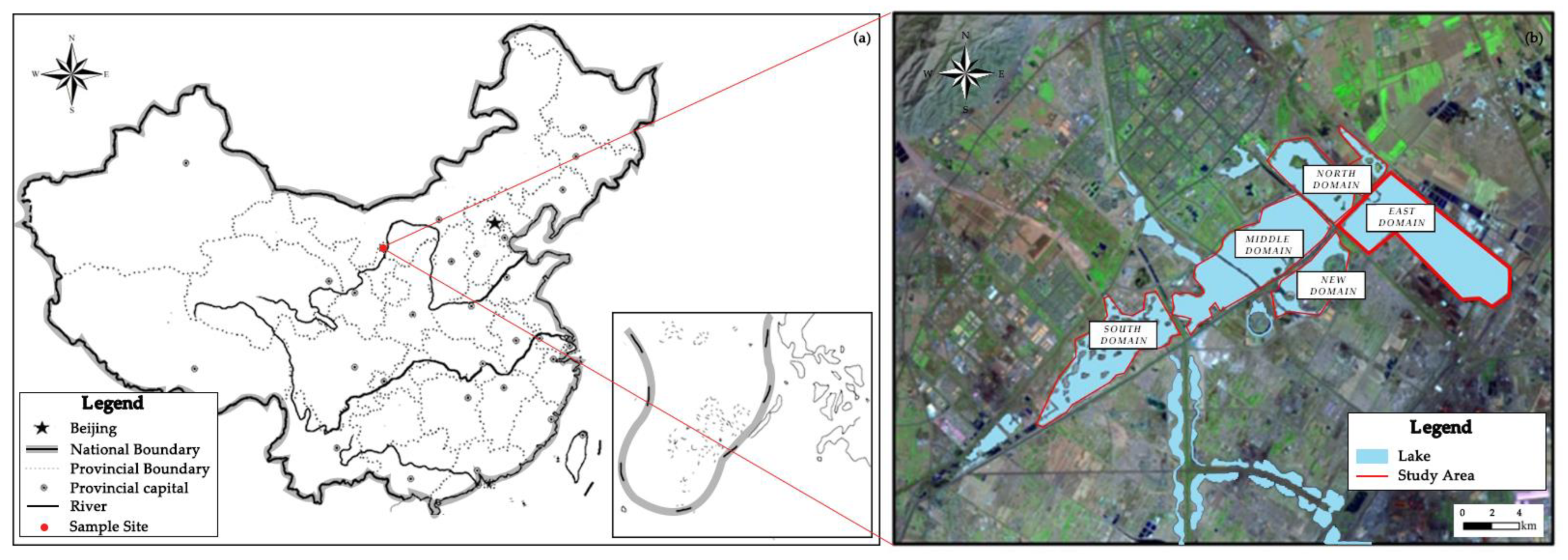
2.1. Study Area

The geographic coordinates of Xinghai Lake (Dawukou flood control reservoir) are 105°58′–106°59′ E and 38°22′–39°23′ N. It has a total area of 43 km2 and a lake area of around 23.38 km2, of which 10.55 km2 is the study area (Figure 1). It is situated in Dawukou District, Shizuishan City, Ningxia Hui Autonomous Region, China. It is also a crucial component of the “72 lakes” water system in the Yinchuan Plain, which primarily performs the tasks of flood control, drainage, improving the water environment, regulating microclimate, and maintaining the ecological balance of the region. It is also a significant protected wetland for the entire area. Xinghai Lake receives 200 to 400 mm of precipitation on average every year, with the amount rising from south to north. Water evaporates at a rate of, on average, between 800 and 1600 mm per year, which is four times more than it rains. As Xinghai Lake has grown and been used more recently, it has used an excessive amount of water; the water environment has become somewhat contaminated, and the water quality is declining.

2.2. Data Source

The data for wind speed and wind direction is taken from the China Ground Cumulative Daily Value Dataset (1981–2010) of the National Meteorological Science Data Center; the data for water level and flow are all taken from the Feasibility Study Report on the Remediation of Ecological and Environmental Problems of Xinghai Lake; the data for precipitation are taken from the average measured data from December 1965 to December 2019 at Pingluo Rainfall Repr.

2.3. Methods

The Xinghai Lake wetland’s landscape water needs should satisfy both the water requirements for wetland operation and the requirements for the tour’s water quality. This is because the wetland’s ecological and environmental functions must be protected as well as its public viewing, leisure entertainment, and aesthetic functions. Placement should take into account the following:
(1)
The water requirements of the actual Xinghai Lake wetland, including those for the plants that grow there, for irrigation in the shoreline zone, and landscape water levels.
(2)
The daily water replenishment of the Xinghai Lake wetland, including precipitation, seepage, and evaporation.
(3)
Starfish Lake wetland replacement water: maintains the landscape water body’s water quality standards, preventing eutrophication and meets the needs of the water environment capacity, protecting the wetland’s functions from being harmed by routine replacement water.

2.3.1. Water Demand Model of Xinghai Lake Landscape Water

In addition to surface water, groundwater and soil water are important sources of water for the landscape. The following factors should be given special attention when determining the water demand for the landscape water bodies in Xinghai Lake [14]:
(1)
Water requirement for evaporation WW:
Since Xinghai Lake is situated in a dry and semi-arid region of northwest interior China, one of the main ways that water is lost from the lake is through substantial regional evaporation. The accounting average for evaporation during a multi-year period is 1107.3 mm, according to observation result data from a meteorological station’s evaporation dish.
(2)
Water demand of wetland vegetation WP:
To sustain their life and ability to reproduce, plants require a lot of water during their growth and development. Plant transpiration accounts for the majority of this water consumption, but soil evaporation also uses up a lot of water. The fundamental physiological water demand of plants in general is only a tiny component and is typically overlooked in the calculation procedure, whereas the ecological water demand of vegetation can be directly estimated by calculating the evapotranspiration of vegetation. The modified Penman formula technique and the Hargreaves algorithm [15] are typically employed in the computation of plant evapotranspiration. The equations can be expressed as:
W P = A ( t ) E T
In the formula: WP is the water requirements of wetland plants, A(t) is the wetland area, E is plant cover, and T is evapotranspiration–emissions.
(3)
Leakage volume WS:
When the water level of the wetland is higher than the groundwater level, infiltration will occur, and the seepage recharge of Xinghai Lake can be determined according to Darcy’s law. The formula for calculating the amount of seepage is:
W S = K A J
In the formula: WS is leakage: K is permeability coefficient, m/d; A is infiltration area, m2; J is hydraulic slope, dimensionless.
(4)
Precipitation WR:
The findings of a lengthy series of meteorological observations show that Shizuishan City experiences relatively little precipitation, with an annual average of 179.8 mm.

2.3.2. A Two-Dimensional Hydrodynamic-Water Quality Model Based on the MIKE 21 Water System Connectivity

(1)
Hydrodynamic model
The model is based on the three-way incompressible Reynolds-valued homogeneous Navier–Stokes equations and obeys the Boussinesq assumption and the assumption of hydrostatic pressure. The two-dimensional non-constant shallow water equation set is [16]:
h t + h u ¯ x + h v ¯ y = h S
h u ¯ t + h u ¯ 2 x + h u v ¯ y = f v ¯ h g h η x h ρ 0 p a x g h 2 2 ρ 0 ρ x + τ x x ρ 0 τ b x ρ 0 1 ρ 0 ( s x x x + s x y y ) + x ( h T x x ) + y ( h T x y ) + h u s S
h v ¯ t + h u v ¯ x + h v ¯ 2 y = f u ¯ h g h η y h ρ 0 p a y g h 2 2 ρ 0 p y + τ s y ρ 0 τ b y ρ 0 1 ρ 0 ( s y x x + s y y y ) + x ( h T x y ) + y ( h T y y ) + h v s S
In the formula: t is time; x, y are Cartesian coordinate system coordinates; η is the water level; d is the resting water depth; h = η + d is the total water depth; u, v is the velocity components in x, y directions, respectively; f is the Gauche force coefficient, f = 2ωsinφ; ω is the angular velocity of the Earth’s rotation; φ is the local latitude; g is the acceleration of gravity; ρ is the density of water; Sss, Sxy, Syy, are the radiation stress components; S is the source term; (us, vs) is the source term current flow rate.
The letters with a crossbar are the average values. For example, is the average flow rate along the water depth, defined by:
h u ¯ = d η u d z , h v ¯ = d η v d z
T i j is the horizontal viscous stress terms, including viscous forces, turbulent stresses, and horizontal convection, and these quantities are derived from the velocity gradient averaged along the water depth using the eddy viscosity equation [17].
T x x = 2 A u ¯ x , T x y = A ( u ¯ y + v ¯ x ) , T y y = 2 A v ¯ y
(2)
Water quality model
Convective diffusion is used in the water quality model, which has the following form in a Cartesian coordinate system [18]:
C t + u C x + w C y + w C z = F c + z ( D v C z ) k p C + C s S
Among them:
F c = [ x ( D h x ) + y ( D h y ) ] C
The integral form of the transport equation can be derived U t + · F ( U ) = S ( U ) as follows:
U = h C ¯ F 1 = [ h u ¯ C ¯ , h v ¯ C ¯ ] F V = [ h D h C ¯ x , h D h C ¯ y ] S = h k p C ¯ + h C s S
The discrete finite volume form of the transport equation is given by U i t + 1 A i j N S F · n Δ Γ j = S i . The numerical format is the same as for the hydrodynamic discrete part.
The MIKE21 FM model employs the finite volume method for the discrete solution of the study area, which is discretized into several irregular triangular meshes, and the mesh is encrypted in the local area to better reflect the complex boundary. The finite volume method ensures the conservation of water volume and momentum in the calculation area [19].
The MIKE21 hydrodynamic module is the foundation of the model simulation, primarily through the study area of the topographic grid processing, control of wet and dry grid conditions, selection of appropriate solution method, and consideration of the model input and output role to calculate the simulation of the study area water depth and flow field distribution law. The hydrodynamic module is built on top of the convective diffusion module, and the two are dynamically related. The convective diffusion module simulates the characteristics of diffusion phenomena occurring in the water body through convection and diffusion processes by setting different types of diffusion coefficients, which has the advantages of ignoring the complex physical, chemical, biological, and ecological processes that occur when pollutants are transported in the water and highlighting the role of the regional water body flow field. The hydrodynamic module and the convective diffusion module were chosen as research methods for this simulation based on the lake’s water environment and the purpose of the study.

2.3.3. Water Displacement Cycle Coupled Hydrodynamic-Tracer Model

The convective diffusion equation in MIKE21 is used to compute the water replacement cycle, and an exponential decay function based on the change in concentration is used to calculate the tracer concentration decay rate (11).
C t = C 0 e t / T t
In the formula: C0 is the initial tracer concentration value; Ct is the remaining tracer concentration value at the time t.
From equation (11), the concentration has decayed to e−1, or 37% of the initial concentration, when t = Tf(V/Q); therefore, the water change cycle is defined as the time required for the remaining concentration to decrease to 37% of the initial concentration [6].

2.4. Study on the Water Balance of the Water Bodies in Xinghai Lake Wetland

The Xinghai Lake Wetland’s water requirement is the amount and quality of water necessary to maintain the wetland’s ecological and environmental functions at a given stage of development and under various ecological and environmental preservation objectives. The following should be included in the water use positioning:
Wetland vegetation and landscape water level are the two main factors that contribute to the Xinghai Lake wetland’s water requirement.
Wetland evaporation water demand and wetland seepage water demand are the two main components of wetland daily water replenishment.
Wetland water body replacement water: maintain the water quality standards of the landscape water body, to ensure that the water body does not experience eutrophication, and the capacity of the water environment to fulfill the periodic replacement water needs.

2.4.1. Water Demand of Xinghai Lake Wetland

Referring to the water balance principle proposed by Liu Jingling [20] and others, and combined with the current characteristics of Xinghai Lake, its ecological water demand can be expressed by the following equation:
W L = W W + W P + W S W R
In the formula: WL is the ecological water demand of the lake wetland, WW is the evaporation water demand of the water surface, Wp is the vegetation water demand of the wetland, WS is the seepage water demand, and WR is the precipitation.
(1)
Evaporation water demand
Xinghai Lake is located in the arid and semi-arid region, and evaporation has emerged as one of the major means of water loss. According to the weather station data, the average annual evaporation of Xinghai Lake is 10,513,800 m3.
(2)
Wetland vegetation water demand
As the reed community makes up the majority of the flora around Xinghai Lake, it is best to split the water demand level according to these fundamental reed features. Calculated from Equation (1), the water demand of Xinghai Lake vegetation is 5,968,800 m3.
(3)
Seepage water demand
The foundation soil layer of the planned water body in this area is mainly vegetation fill, powder clay, sandy loam, fine sand, etc. The permeability coefficient of this study is 0.0001 m/d, and the hydraulic slope is 1. The annual seepage of Xinghai Lake is calculated by Equation (2) as 385,100 m3.
(4)
Precipitation
One of the key sources of replenishment for the water of Xinghai Lake is natural precipitation. The Xinghai Lake region experiences an average of 179.8 mm of precipitation annually, as determined by data collected from meteorological stations in Shizuishan City between 1988 and 2019. According to calculations, the natural precipitation volume in Xinghai Lake’s water is 1,896,900 m3, based on the lake’s 10.55 km2 water surface area.
According to the above calculation results, the annual water demand of Xinghai Lake wetland is about 14,970,800 m3.

2.4.2. The Water Requirement of Landscape Water Level in Xinghai Lake Wetland

There is not yet a standardized calculating technique or water need for landscape water level. This study primarily relies on the fundamental characteristics of Xinghai Lake as a flood control reservoir in the former plain of Helen Mountain and combines them with the ground elevation of the river bottom to establish the Xinghai Lake landscape water level. The five domains of Xinghai Lake are as follows: south, middle, north, east, and new domains. Three water levels are selected based on the wetland park’s landscape purpose.
(1)
Minimum wetland water level
According to Table 1, the minimum water level in the south domain is 0.2 m, the minimum water level in the middle and north domains is 1.3 m, and the minimum water level in the east domain is 0.1 m. The one-time water demand for filling the reservoir = water surface area × water level = 982.29 million m3.
(2)
Standard wetland water level
Table 1 shows that the typical water level in the south domain is 0.3 m, the center and north domains are 1.4 m, the east domain is 0.2 m, and the total amount of water needed to fill the reservoir is 1081.79 million m3.
(3)
Maximum wetland water level
Table 1 shows that the south domain’s maximum water level is 0.4 m, the center and north domains’ maximum water levels are 1.5 m, and the east domain’s maximum water level is 0.3 m. A total of 1174.29 million m3 of water will be needed to fill the reservoir all at once.
Calculating the water demand can be directly performed using water increment = water surface precipitation—water evaporation—water leakage = −9.002 million m3. The investigation found that, after evaporation and seepage loss of the water, the quantity of natural precipitation entering Xinghai Lake’s water could not satisfy the minimal demand for water needs. When the reservoir is filled all at once, 11,742,900 m3 of water—considering the usual situation of water availability—is stored to sustain the wetland’s functional landscape. The lake should be permitted to sink into other water sources when the water level reaches the minimal water level during operation.

2.5. Hydrodynamic Water Quality Modeling

2.5.1. Calculation Area and Grid

ArcGIS technology is used to vectorize the Xinghai Lake lake border, convert it to an XYZ file, create the lake boundary using MIKE ZERO, and then utilize a grid generator to create an unstructured grid representing the interior topography of the Xinghai Lake region, as shown in Figure 2a. The model uses a triangular mesh to adapt to the complex lake bottom topography and shoreline of Xinghai Lake, and the overall encryption of the mesh for part of the river is shown in Figure 2b. The topographic interpolation is carried out using the natural neighboring point interpolation method in the natural cell method, and the topographic data file of Xinghai Lake is obtained, and the elevation is shown in Figure 2c. A total of 41,341 grids and 24,447 nodes are generated for Xinghai Lake.

2.5.2. Boundary Conditions and Output

With the specified flow boundary conditions, the north domain C1 serves as the inlet boundary, and the north domain C2 serves as the outlet boundary. According to different water quality conditions (Figure 3), the model sets up eight source sinks from the east domain outflow S6 to the south domain inlet S1, from the east domain outflow S8 to the middle domain inlet S7, from the south domain outflow S2 to the middle domain inlet S3, and from the north domain outflow S4 to the east domain inlet. This is performed to account for the impact of wind on the local lake flow.

2.5.3. Simulation Scheme and Model

To simulate the water exchange cycle distribution of Xinghai Lake, the hydrodynamic module and convective diffusion module of MIKE21 FM are used and linked with:
(1)
Initializing the concentration of the tracer material in Xinghai Lake’s water column at 100 and its inflow concentration at 0.
(2)
The simulation duration was chosen as 1st April 2020–1st November 2020, comprising 214 d, taking into account Xinghai Lake’s chilly winter and the lengthy freezing period of the water body.
(3)
For the simulation, six distinct flow conditions are chosen, as shown in Table 2, with the water quality in Xinghai Lake’s middle domain serving as the study object.

3. Results and Discussion

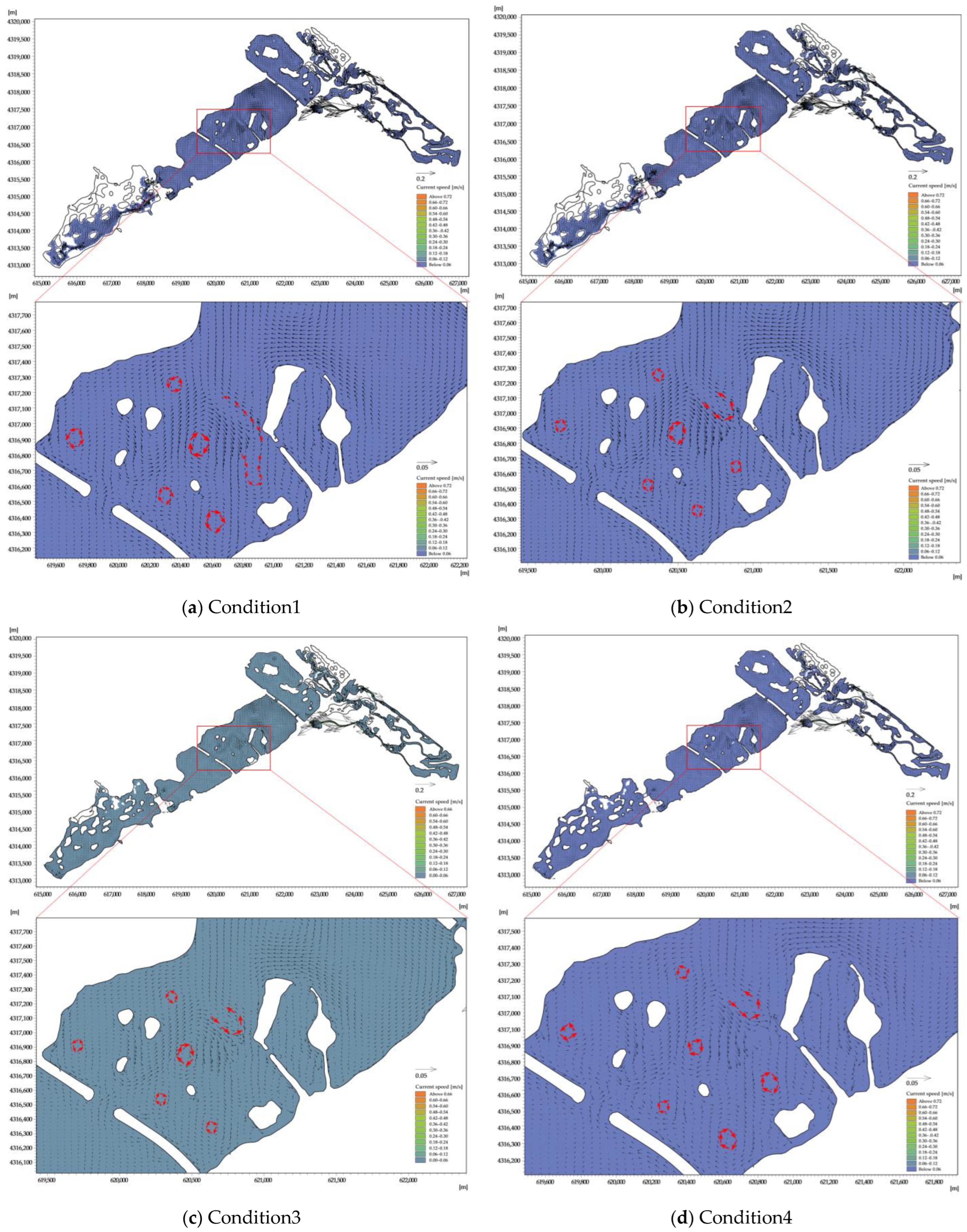
3.1. Flow Field Analysis

The MIKE21 Flow Model was used to execute the hydrodynamic simulation of the Xinghai Lake diversion scheduling scheme, and the results of the simulation of the Xinghai Lake water’s flow field were obtained. Table 3 and Figure 4 shows that the wind field, throughput flow, and lake shape all influence the Xinghai Lake flow field’s structure, which, in turn, has a significant bearing on the pollution transport process and the vast shallow lake’s capacity for water regeneration [21].
The average water level in the south domain is lower when the S2 outflow flow is 0.7 m/s, the average value is 1096.97m, and the flow velocity is higher in the area with lower topography, which is 1.6 times higher than that when the outflow flow is 0.35 m/s, essentially forming a “river form.” The flow field of Xinghai Lake is primarily influenced by the inlet flow, as seen in Figure 4. The water area increased 1.2 times and 1.3 times in comparison to the outflow of S2 at 0.7 m/s, resulting in a water level in the south region of 1098.28 m and an area covered by water accounting for 83.18%. This suggests that when the water level is lower, the water flow is quicker, increasing the dilution of pollutants, lowering the danger of local eutrophication, and enhancing the water’s ability to interchange water.
The water flow may have been introduced into the middle domain at S3 and S7, and the collision between the artificial islands and the water flow in the path of water movement may have caused the water flow to be disturbed and change direction to form the circulation, as can be seen in Figure 4. Several obvious circulation areas are formed close to the artificial islands in the middle domain. The near-shore lake region is affected by the wind field under the wind velocity of 1.8 m/s, which causes the overall circulation to be strengthened and a smaller circulation to emerge. This causes positive circulation in the northeastern section of the middle domain with a flow velocity of 0.002~0.3 m/s. Because of the tiny diversion flow, sluggish flow velocity, and limited effect of the throughput flow, which is mostly driven by the wind field, the area of the stagnant region in the middle domain in Condition 3 grows by 4.7% compared to Condition 1, and by 35.7% compared to Condition 2. In Condition 4, the diversion volume in the middle domain S3 is less, the lake’s water flow condition is more steady than it was in Condition 1, and less gyratory area is generated. A positive gyratory zone with a flow velocity of around 0.003–0.02 m/s forms in the northeastern nearshore area of the lake in the northern portion of the middle domain as a result of the wind field’s influence. The hydrodynamic force of the water at the entrance and outflow, as well as at the artificial island, is stronger, the water area in the central domain of Xinghai Lake is bigger, the flow velocity in the central region of the water body is lower, and the flow of the water body is more visible.
When the water is abundant in Condition 1 and scarce in Condition 2, the average flow velocity in the north of Xinghai Lake is 0.0043 m/s, which is virtually stagnant, and 56% less than the average flow velocity of 0.0098 m/s in the outgoing lake region. Several clockwise circulation vortices are seen along the beach underneath the wind field, indicating that a portion of the north domain is primarily driven by the wind-generated flow. The north domain’s stagnant area is higher than that of the other domains due to the slower flow velocity (Table 4), which suggests that the influence of external input pollution load on changes in the north domain’s water quality is less pronounced. At the same time, under the hydrodynamic conditions of slow flow velocity, the pollutants in the water body are easily accumulated, increasing the risk of water wars in the water body.
According to the findings of the previous calculations, the east domain’s highest water level is 0.3 m. Table 3 displays the simulated water level in the east domain for each operational scenario. According to Table 4, when the outflow water volume of condition 5 is cut in half compared to other conditions, and the average flow velocity is 0.003 m/s, which is roughly 88% lower than that of condition 1’s 0.025 m/s, the stagnant area in the east domain exceeds 10 times the area of other conditions. It shows that when the east domain’s water volume is smaller and the water level is lower, throughput flow has a greater influence and the flow velocity is faster, but when the east domain’s water volume is larger and the water level is higher, the wind-generated flow has a greater influence and the flow velocity is slower. The nitrogen and phosphorus nutrients in the water body are primarily present in a dissolved state and under conditions of high concentration and slow water flow.
The average flow velocity is greater than 0.01m/s in all conditions (except Condition 5), and the flow field distribution is similar, but the flow velocity is slower in the near-shore and lake island areas of the central domain, and small eddies appear. This indicates that, in large landscape lakes, the flow velocity of the water body in some areas does not change much with increasing diversion flow, and the main driving force for pollutant transport in these areas is wind-generated flow, which is consistent with Tang et al. [22] conclusion’s that wind is the main force affecting water flow when there is no water input. As a result, when determining the diversion flow rate, the average flow rate cannot be considered, as in the case of a flat landscape channel, but rather the flow rate distribution of the entire water body. Increasing the diversion flow rate will only result in a waste of energy in local stagnant areas. Managers can consider increasing the number of diversion points to more effectively promote the flow of water bodies, or they can implement ecological water quality treatment methods such as ecological berms and the addition of ecological floating islands to reduce the risk of eutrophication in the stagnant water area. The flow field analysis model can be combined with other physical, chemical, and ecological methods in future studies to provide a reference for the application of other water quality treatment measures.

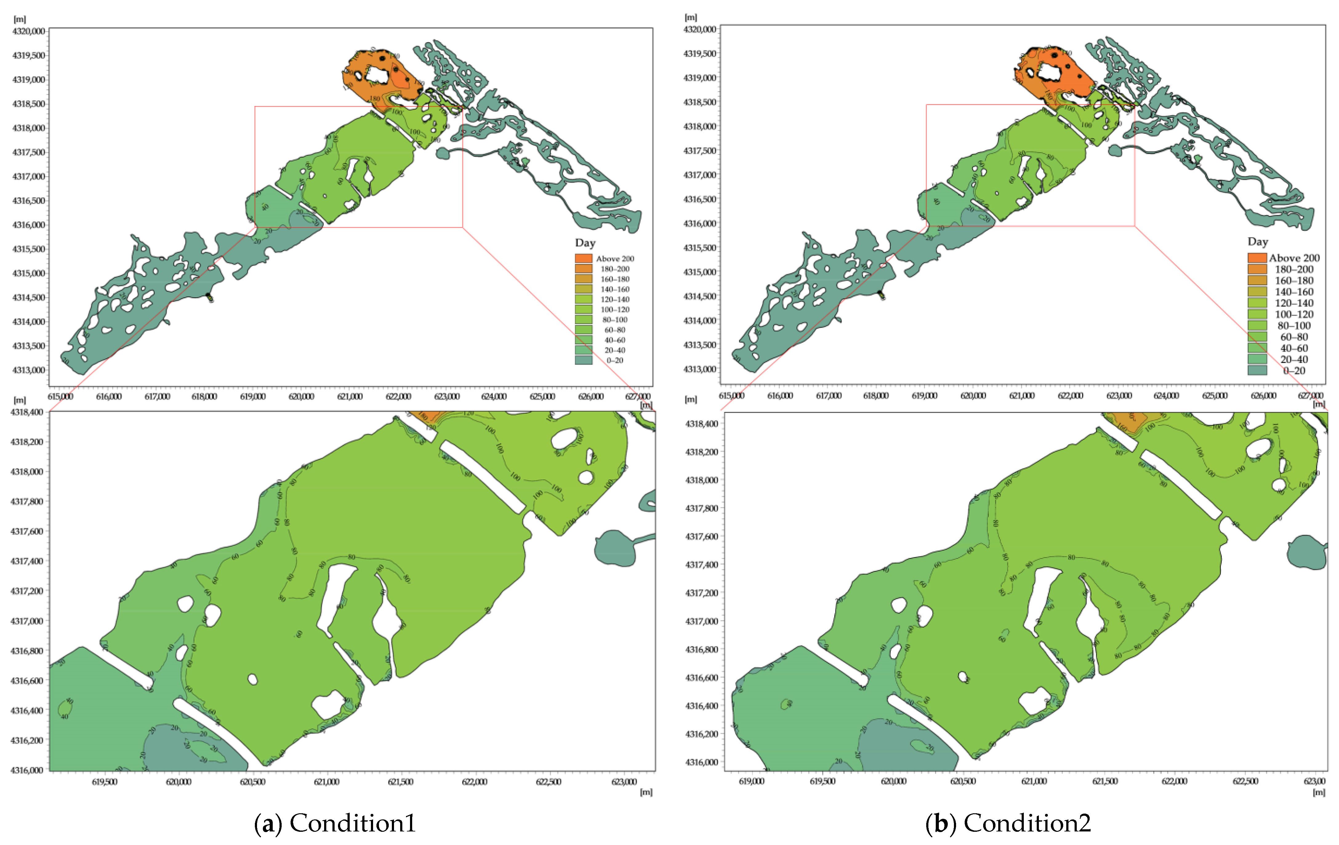
3.2. Water Replacement Cycle Analysis

The number of days of water replacement in each domain of Xinghai Lake under six conditions was calculated by simulating 214 d of the water replacement cycle. The water exchange cycle of Xinghai Lake is spatially heterogeneous, as can be observed in Figure 5 and Figure 6. The general features of the water body renewal period in the southern lake region are quick, and those in the northern lake area are sluggish.
The water exchange capacity of Xinghai Lake benefits from the high flow rate, and the throughput flow might encourage the transit and dispersion of contaminants. Generally, the mean value of the lake’s water exchange cycle decreases as the flow increases, as shown in Figure 5. In Condition 1 and 2, the lake’s whole water exchange period’s geographical distribution is comparable. The middle domain exhibits increasing characteristics from the southern inlet to the northern outlet area, with average water exchange periods of 14 d and 74 d, respectively, and there is no discernible difference between the observation points in the middle domain. The south and east domains have a stronger water exchange capacity, with water exchange periods of 6 d and 4 d, respectively, as shown in Figure 5. The northern region has the longest average water exchange times, between 114 and 118 days. While the water flow in other regions is slow and the water exchange capacity is poor, with an average value of 200 d, the local water exchange near the lake’s mouth is quicker, within 100 d. The average water exchange periods of the whole lake in Condition 2 and Condition 1 are 52 d and 32 d, respectively, and the diversion flow in Condition 2 is 46% smaller than that in Condition 1, which increases the water exchange period by 38%.
The diversion flow at S3 in the middle domain in Condition 3 is reduced by 50% compared with Condition 1, resulting in a weakened renewal capacity of the water body in the whole lake, and the mean value of the water exchange cycle is 62 d, an increase of 94% compared with Condition 1. Among them, the average value of the water exchange cycle in the northern lake area of the middle domain is 97 d, an increase of 31% compared with Condition 1, indicating that the flow accelerates the water flow in the middle domain of Xinghai Lake and enhances the dilution capacity of pollutants in this area, which is an important driving force affecting the transport of pollutants in Xinghai Lake. The average water exchange period in the outgoing area of the northern domain is 155 d, which is 55% higher than that of working condition 1, and the water exchange period in other areas is 210 d, which is 5% higher than that of working condition 1. The water exchange capacity of the outgoing lake area is significantly weakened, indicating that the throughput flow is the most important factor affecting the water renewal in this area.
The average water exchange duration increased by 16% while the average water diversion in condition 4 reduced by 46% compared to condition 3, showing a positive correlation between the two variables. The average water exchange duration in the middle domain is 43 days, which is 31% and 20% greater than that of Condition 3. The average value in the southern lake region is 17 days, while the average value in the northern lake area is 83 days. As seen in Figure 6d, the lake area of the active line of water flow in the northern part of the middle domain has a higher water exchange capacity than the near-shore circulation area, and the average water exchange period is about 21% longer. The lake area out of the northern domain also has a significantly longer water exchange period than the non-outflow area, and the average value is about 99 d less.
The average water exchange period in Condition 5 is 80 d, which is 1.5 times higher than that in Condition 1. Among them, the water exchange period in the middle domain is 86 d, and that in the north domain is 156 d, which are 79% and 37% higher than that in Condition 1, respectively. It indicates that the reduction of the inlet flow will significantly affect the regional water exchange capacity and cause the water exchange cycle to be prolonged.
Under the aforementioned circumstances, Xinghai Lake’s water renewal period is simulated. Figure 7 shows the concentration–time curve for the middle domain observation point. According to the findings, the residual mass of preserved material in the lake is a time-dependent function. The residual conservative material in the lake steadily diminishes with time and goes to zero, but its value is never zero, indicating that residual un-excluded material exists in the lake at all times. Because the observation point is closest to the active water flow line and has the shortest water flow path among them, the water flow diffusion to this location collides with the artificial island and changes direction, impeding the diffusion to the north and resulting in the oscillation of water body exchange. The water renewal time of the observation points for Condition 3 and 5 slows down significantly when the diversion flow of S3 decreases. This is because the lake area in which the observation point in the middle domain is located is affected by the throughput flow, and when the incoming water flow is low, there is not a significant difference in the water renewal period between the observation points for Condition 1 and 2, as can be seen from Figure 7.
There is a clear regional variation in the Xinghai Lake’s water renewal time. The water exchange cycle is shorter the closer the water is to the inlet and outlet because the water flow is higher and the flow path is the shortest; next comes the artificial island close to the main flow path because the water flow collides with the artificial island to create a larger circulation; and, finally, the near-shore area is the slowest, because the water flow is less influenced by the throughput flow, the hydrodynamic force is insufficient, and the water body is closer to the shore. According to the simulation study of the water body renewal cycle, the main driving force of Xinghai Lake is the clean water source introduced from outside, while the driving force of surrounding rainfall and wind is very limited. If the external water source carries pollutants into the lake, it will pose a serious threat to the water quality of Xinghai Lake. As a result, other engineering measures, such as increasing the purification capacity of the east domain wetland, introducing the water body from the north domain outlet to the east domain wetland via a pumping station, and then introducing the purified water body via the pumping station after the wetland has dissipated pollutants and improved water quality must be considered to order to provide a stable water body for Xinghai Lake.

4. Conclusions

(1)
Xinghai Lake’s water exchange cycle is spatially heterogeneous, exhibiting general characteristics of rapid water renewal in the southern lake area and slow renewal in the northern lake area. The gradient of the water exchange cycle from south to north is closely related to Xinghai Lake’s hydrological situation.
(2)
The flow rate, terrain, and wind field all have an impact on the Xinghai Lake flow field. The topography and flow velocity have an impact on the development of many complicated circulations close to the artificial island. The wind field affects the near-shore region, which creates a tiny circulation with a modest flow velocity.
(3)
Xinghai Lake is influenced by throughput flow; under high flow conditions, the flow velocity in the lake area is larger, the water body transport speed is faster, and the water exchange capacity is strong; under low flow conditions, the flow velocity in the lake area is slower, the water body mobility is poor, and the water exchange period is longer. Xinghai Lake has a large water area, a complex flow field, and a low flow velocity, and it is a lake system.
(4)
Without new water inlets and outlets, the center and northern domain of Xinghai Lake will create a significant area of stagnant water, which does not fulfill the requirements for the water quality of the landscape water body. To optimize the renewal time of the water body, it is recommended to enhance the inlet and outlet and incorporate additional alternative water sources.
(5)
The numerical model can be used to determine the flow velocity distribution and hydraulic residence time in the water body, which can be used as an important tool for future water environment management in urban landscape lakes.

Author Contributions

Conceptualization, G.X. and M.W.; methodology, M.W.; software, M.W. and X.N.; validation, M.W.; formal analysis, M.W.; investigation, M.W. and X.N.; resources, Z.F. and X.L.; data curation, M.W. and X.N.; writing—original draft preparation, M.W.; writing—review and editing, M.W.; visualization, M.W.; supervision, G.X.; project administration, Z.F.; funding acquisition, Z.F. All authors have read and agreed to the published version of the manuscript.

Funding

This research received no external funding.

Data Availability Statement

All data generated or analyzed during this study are included in this published article.

Conflicts of Interest

The authors declare no conflict of interest.

References

  1. Whipple, W., Jr.; Duflois, D.; Grigg, N.; Herricks, E.; Holme, H.; Jones, J.; Keyes, C., Jr.; Ports, M.; Rogers, J.; Strecker, E.; et al. A proposed approach to coordination of water resource development and environmental regulations. JAWRA J. Am. Water Resour. Assoc. 1999, 35, 713–716. [Google Scholar] [CrossRef]
  2. Tisdell, J.G. The environmental impact of water markets: An Australian case study. Jocase Study Environ. Manag. 2001, 62, 113–120. [Google Scholar] [CrossRef] [PubMed] [Green Version]
  3. McCallum, B.E. Areal extent of fresh water from an experimental release of Mississippi RiMississippinto Lake Pontchartrain. In Proceedings of the 9th 1995 Conference on Coastal Zone, Tampa, FL, USA, 16–21 July 1995; pp. 363–364. [Google Scholar]
  4. Cox, W.E. Interbasin water transfer in the United States: Overview of the institutional framework. In Proceedings of the IWRA Seminar on Interbasin Water Transfer, Beijing, China, 15–19 June 1986. [Google Scholar]
  5. Xu, L.; Gao, X.; Zhang, C.; Wang, C. Numerical simulation-based study on exchange of water in urban artificial lake. Water Resour. Hydropower Eng. 2018, 49, 94–100. [Google Scholar]
  6. Tang, J.Z.; Zhou, W.B.; An, B.J.; Yang, H.; Li, Y. Research on characteristics of water change capability of Kunming Lake (test section) in Xi’an based on the MIKE 21 Model. J. Water Resour. Water Eng. 2020, 31, 58–63. [Google Scholar]
  7. Cucco, A.; Umgiesser, G. Modeling the Venice Lagoon residence time. Ecol. Model. 2006, 193, 34–51. [Google Scholar] [CrossRef]
  8. Delhez, É.J.; de Brye, B.; de Brauwere, A.; Deleersnijder, E. Residence time vs influence time. J. Mar. Syst. 2014, 132, 185–195. [Google Scholar] [CrossRef]
  9. Meng, Q.B.; Liu, Y.Z.; Tan, Y.M.; Guo, L.; Zhou, Q.J. Study on Water Quantity and Quality Coupled Simulation of Daming Lake and Delivery Scheme. Water Resour. Power 2008, 26, 24–26. [Google Scholar]
  10. Xu, W.J. Comprehensive Water Requirement Analysis and Ecosystem Health Assessment of Urban Lakes. Ph.D. Thesis, Dalian University of Technology, Dalian, China, 2009. [Google Scholar]
  11. Wang, S.Q.; Shi, W.; Ouyang, H.; Qiu, X.C.; Zhao, Z.F.; Li, Y.L. Study on the ecological water supply of Xinghai Lake based on water quantity and quality model. J. Gansu Agric. Univ. 2020, 55, 180–186. [Google Scholar]
  12. Welch, E.B.; Barbiero, R.P.; Bouchard, D.; Jones, C.A. Lake trophic state change and constant algal composition following dilution and diversion. Ecol. Eng. 1992, 1, 173–197. [Google Scholar] [CrossRef]
  13. Donabaum, K.; Schagerl, M.; Dokulil, M.T. Integrated management to restore macrophyte domination. Hydrobiologia 1999, 395–396, 87–97. [Google Scholar] [CrossRef]
  14. Yang, W.; Sun, Z.F.; Sun, T. A Review of Requirement Quantity and Allocation of Ecological Water for Wetland. Wetl. Sci. 2008, 6, 531–535. [Google Scholar]
  15. Hu, G.L.; Zhao, W.Z. Reviews on calculating methods of vegetation ecological water requirement in arid and semiarid regions. Acta Ecol. Sin. 2008, 28, 6282–6291. [Google Scholar]
  16. Xu, M.J.; Yu, L.; Zhao, Y.W.; Li, M. The Simulation of Shallow Reservoir Eutrophication Based on MIKE21: A Case Study of Douhe Reservoir in North China. Procedia Environ. Sci. 2012, 13, 1975–1988. [Google Scholar] [CrossRef] [Green Version]
  17. Li, X.; Huang, M.; Wang, R. Numerical Simulation of Donghu Lake Hydrodynamics and Water Quality Based on Remote Sensing and MIKE 21. ISPRS Int. J. Geo-Inf. 2020, 9, 94. [Google Scholar] [CrossRef] [Green Version]
  18. Zhu, C.; Liang, Q.; Yan, F.; Hao, W. Reduction of Waste Water in Erhai Lake Based on MIKE21 Hydrodynamic and Water Quality Model. Sci. World J. 2013, 2013, 958506. [Google Scholar] [CrossRef] [PubMed] [Green Version]
  19. Wang, Q.; Peng, W.; Dong, F.; Liu, X.; Ou, N. Simulating Flow of An Urban River Course with Complex Cross Sections Based on the MIKE21 FM Model. Water 2020, 12, 761. [Google Scholar] [CrossRef] [Green Version]
  20. Liu, J.L.; Yang, Z.F. A study on the calculation methods of the minimum eco-environmental water demand for lakes. J. Nat. Resour. 2002, 17, 604–609. [Google Scholar]
  21. Schoen, J.H.; Stretch, D.D.; Tirok, K. Wind-driven circulation patterns in a shallow estuarine lake: St Lucia, South Africa. Estuar. Coast. Shelf Sci. 2014, 146, 49–59. [Google Scholar] [CrossRef]
  22. Tang, C.; Yi, Y.; Yang, Z.; Zhang, S.; Liu, H. Effects of ecological flow release patterns on water quality and ecological restoration of a large shallow lake. J. Clean. Prod. 2018, 174, 577–590. [Google Scholar] [CrossRef]
Figure 1. Study area. (a) Location of the project; (b) Scope of the study.
Water 15 01374 g001
Figure 2. Modeling the hydrodynamics and water quality of Xinghai Lake.
Water 15 01374 g002
Figure 3. Boundary conditions and sources.
Water 15 01374 g003
Figure 4. Flow field distribution.
Water 15 01374 g004aWater 15 01374 g004b
Figure 5. Average water change interval of each domain of Xinghai Lake.
Water 15 01374 g005
Figure 6. The water transfer process of Xinghai Lake.
Water 15 01374 g006aWater 15 01374 g006b
Figure 7. Concentration curves with time at the observation sites in the central domain of Xinghai Lake.
Water 15 01374 g007
Table 1. The domain and water level of Xinghai Lake.
DomainWater Surface (km2)Minimum Water Level (m)Standard Water Level (m)Maximum Water Level (m)
South domain1.540.20.30.4
Central domain5.071.31.41.5
North domain1.941.31.41.5
East domain0.70.10.20.3
New domain1---
Table 2. Diversion scheduling scheme of Xinghai Lake.
Condition1/(m3/s)Condition2/(m3/s)Condition3/(m3/s)Condition4/(m3/s)Condition5/(m3/s)
Code0.80.550.80.550.8
10.70.70.70.70.7
2−0.7−0.7−0.35−0.35−0.7
30.70.70.350.350.7
4−1.39−1.39−1.39−1.39−1.39
51.391.391.391.391.39
6−0.7−0.70.7−0.7−0.7
70.70.70.70.70
8−0.7−0.7−0.7−0.70
Table 3. Hydrodynamic simulation for each working condition.
ConditionAverage Water Level/mAverage Flow Rate (m/s)Maximum Flow Rate (m/s)
South
Domain
Central
Domain
North
Domain
East
Domain
11096.971098.661098.711095.710.01260.69
21096.971098.31098.411095.710.01300.69
31098.281098.241098.341095.710.01120.69
41098.651098.241098.331095.710.01120.65
51096.981098.261098.381100.130.00590.65
Table 4. Area of the water retention zone.
ConditionStagnant Water Zone Area Ratio (%)
South DomainCentral DomainNorth DomainEast Domain
19.4016.6319.576.37
29.3012.8319.806.04
320.5217.4121.957.04
418.3212.2023.996.04
59.3813.4621.5173.47
Disclaimer/Publisher’s Note: The statements, opinions and data contained in all publications are solely those of the individual author(s) and contributor(s) and not of MDPI and/or the editor(s). MDPI and/or the editor(s) disclaim responsibility for any injury to people or property resulting from any ideas, methods, instructions or products referred to in the content.

