

Estimation of Lake Storage Based on the Surrounding Topography around the Lake from the SRTM DEM

Abstract
:1. Introduction
2. Study Sites and Datasets
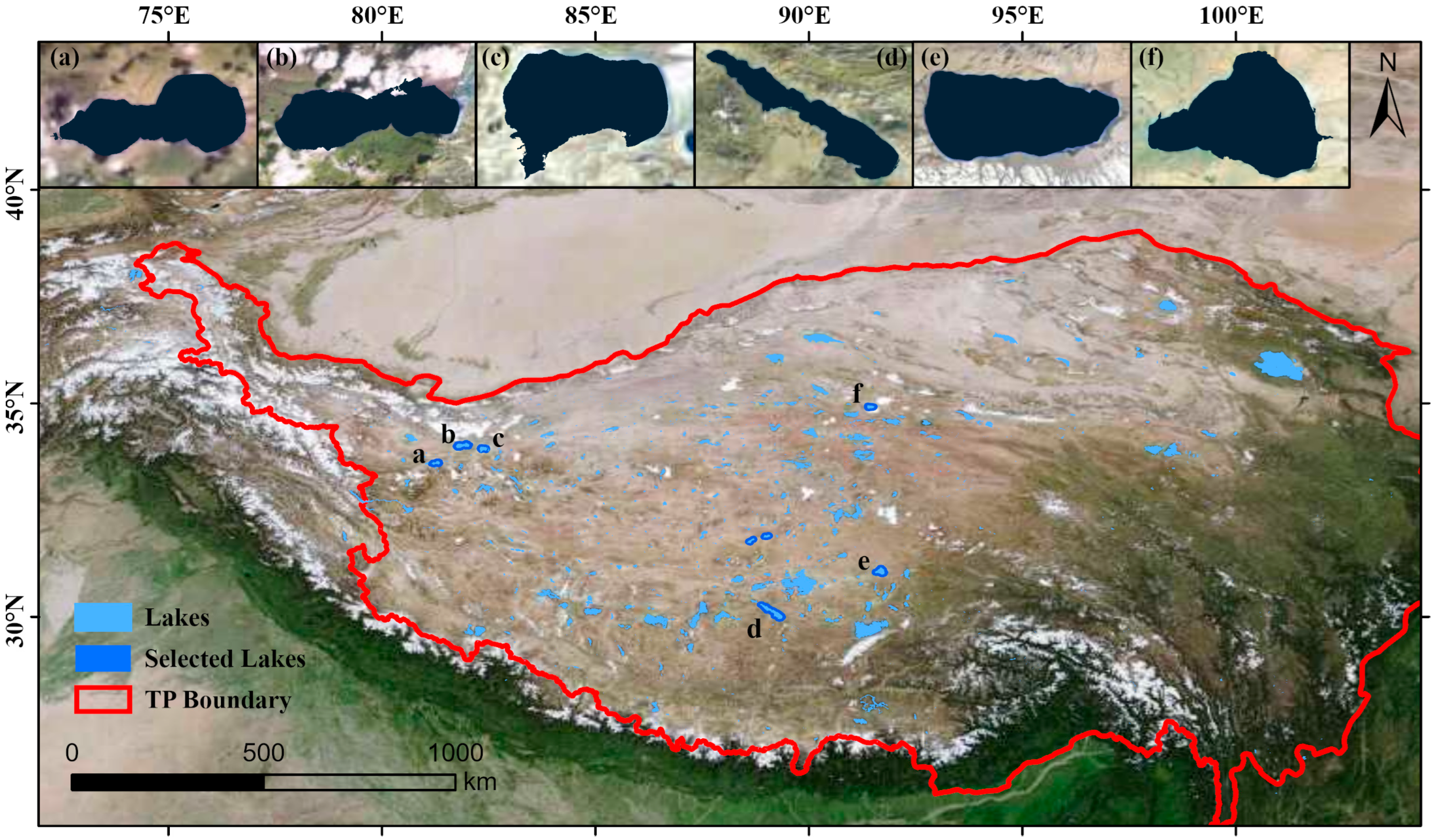
2.1. Study Sites
2.2. Data Source
3. Methodology
3.1. Basic Principle
3.2. Specific Steps
3.2.1. Step 1: Estimate the Maximum Water Depth of the Lake
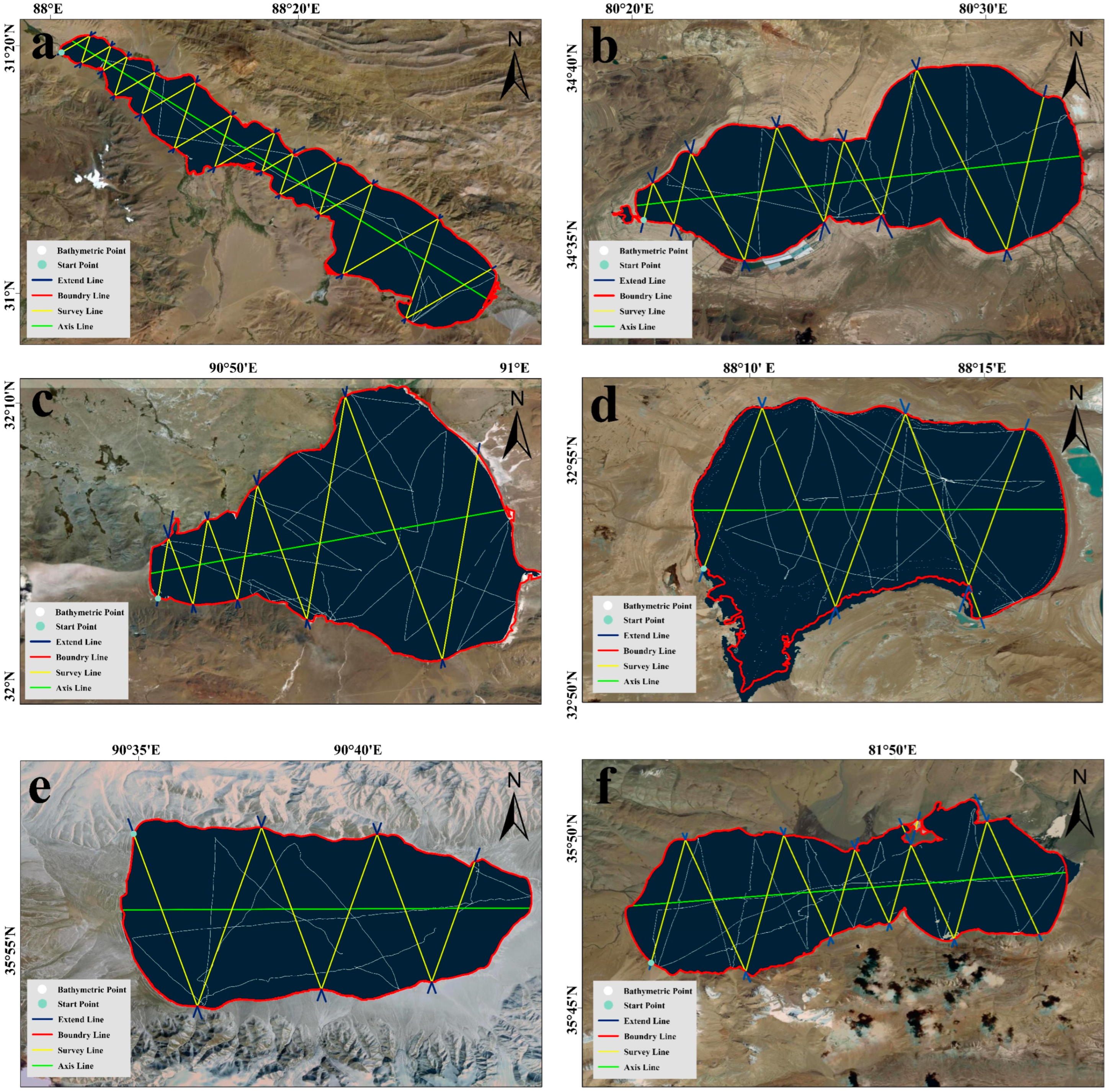
3.2.2. Step 2: Selection of Underwater Interpolation Routes for Lakes
3.2.3. Step 3: Estimation of the Water Depth at the Underwater Interpolation Route Pixel Point
3.3. Evaluation Indicators
4. Results and Discussions
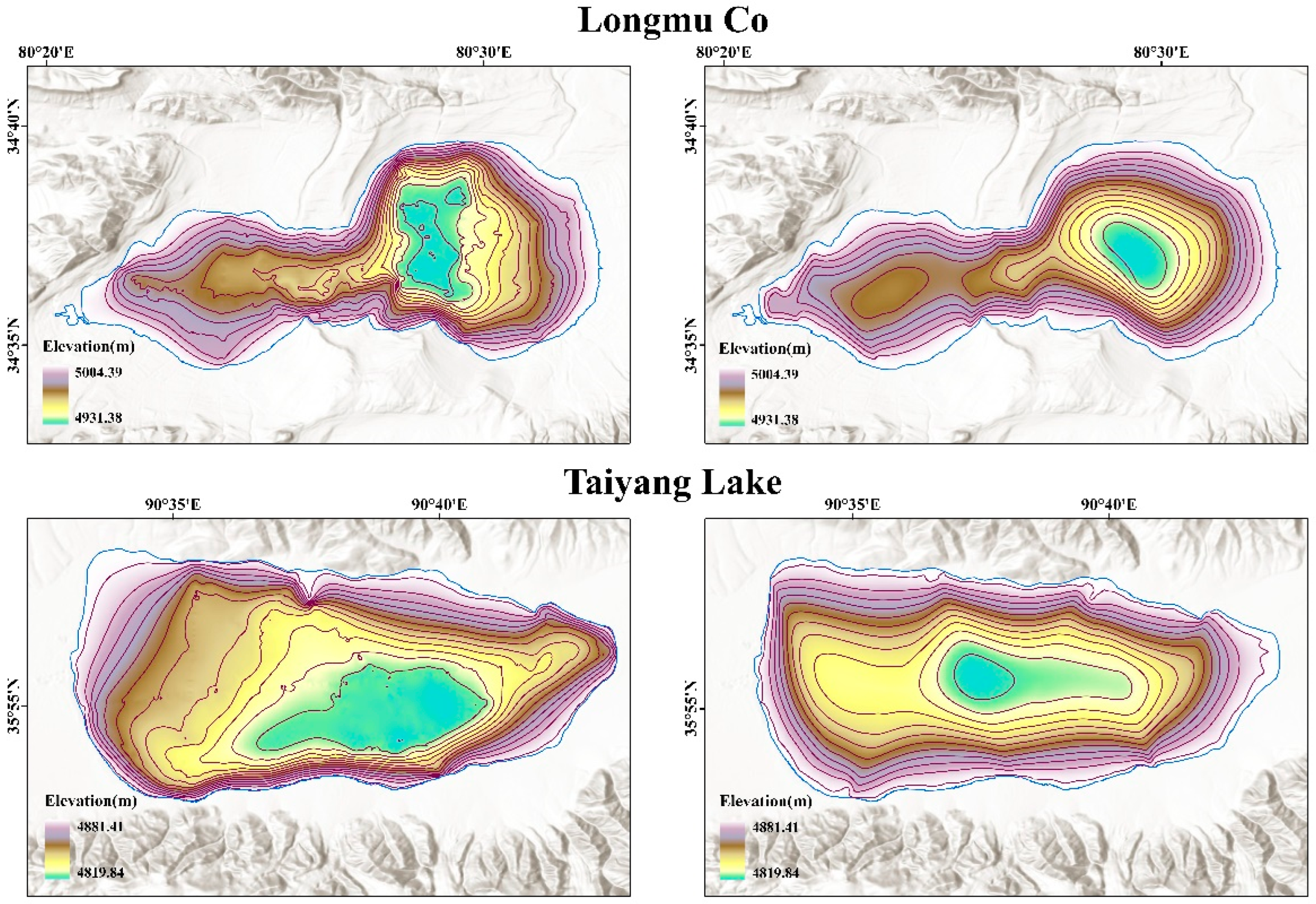
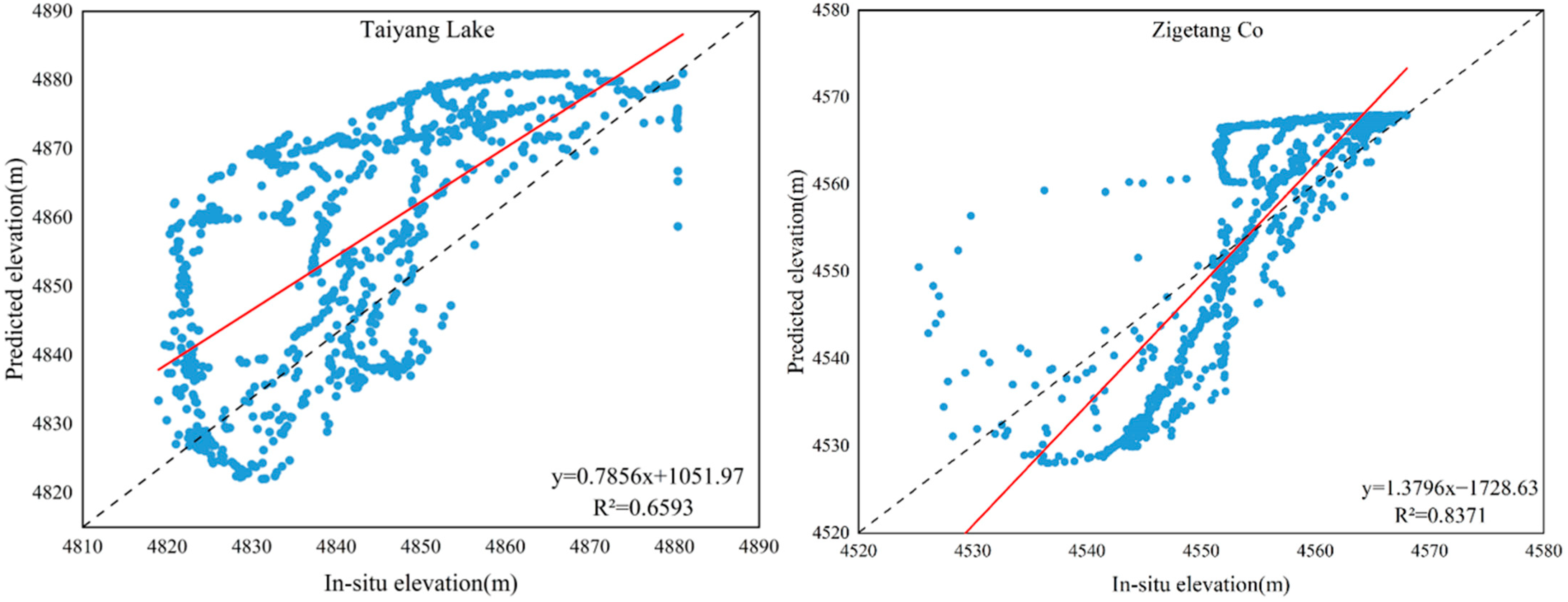
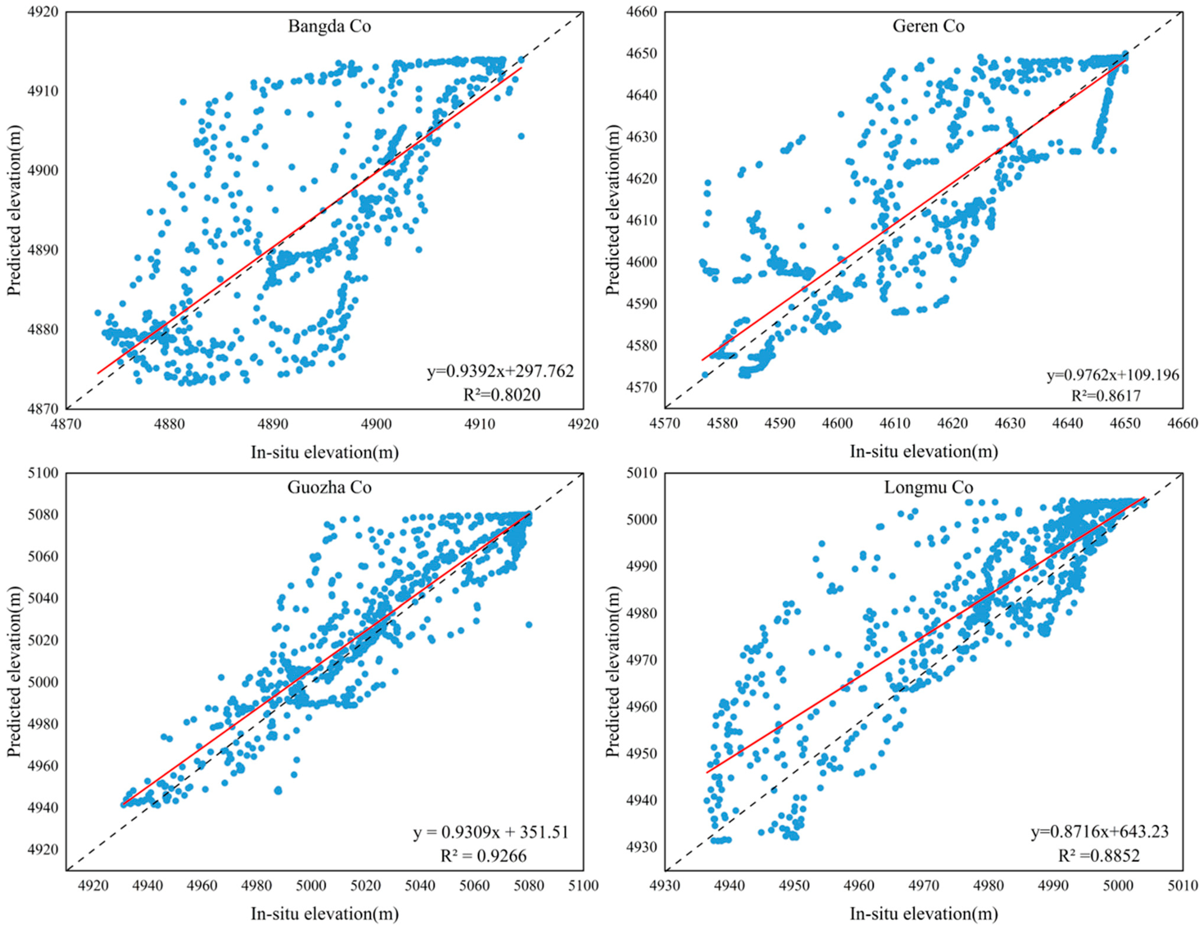
4.1. Evaluate the Accuracy of Lake Bathymetry and Storage Estimation
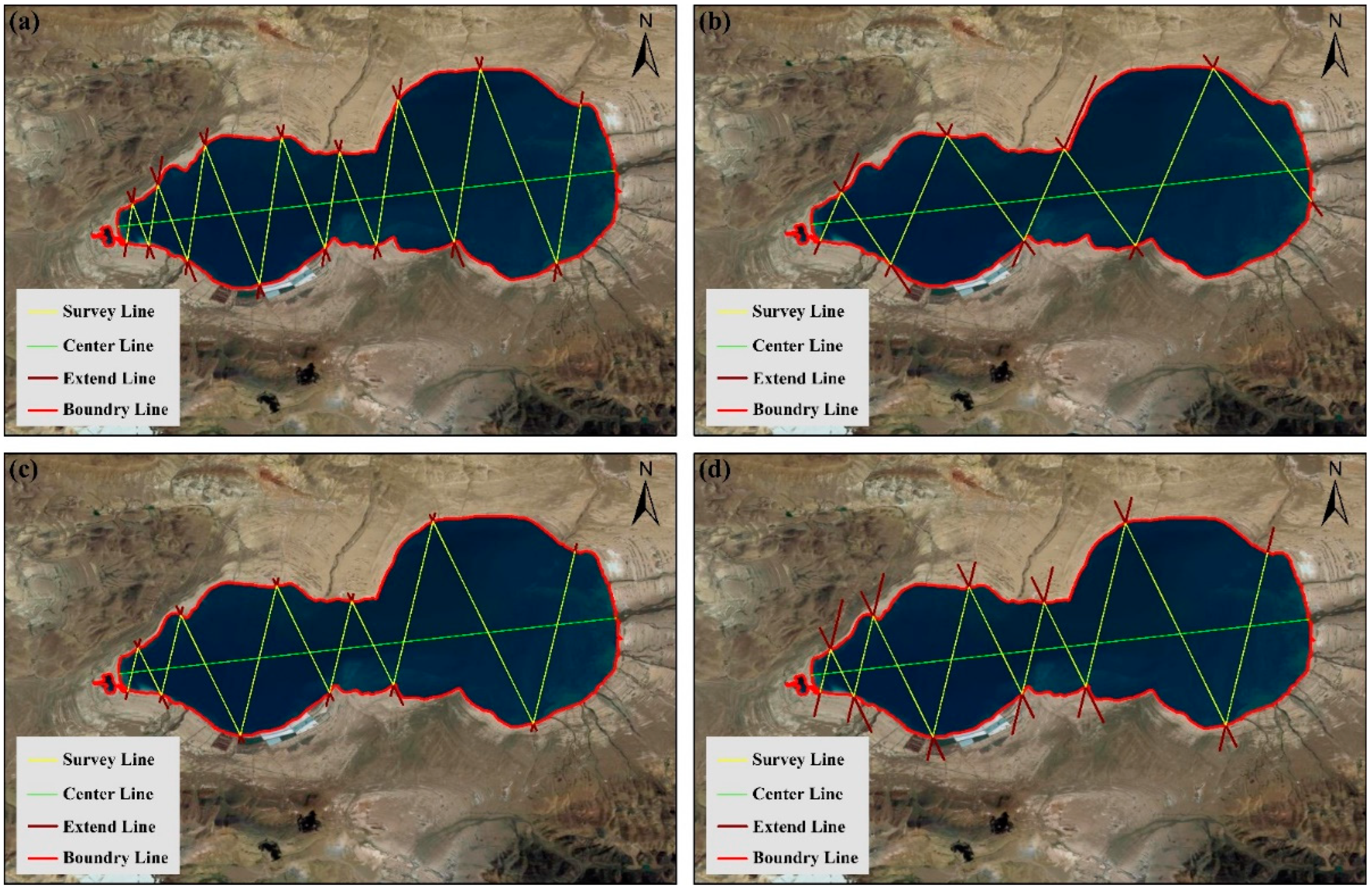
4.2. Influence of Different Parameters on the Accuracy of Bathymetry Estimation
5. Conclusions
Author Contributions
Funding
Data Availability Statement
Conflicts of Interest
References
- Tranvik, L.J.; Downing, J.A.; Cotner, J.B.; Cotner, J.B.; Loiselle, S.A.; Striegl, R.G.; Ballatore, T.J.; Dillon, P.; Finlay, K.; Fortino, K.; et al. Lakes and Reservoirs as Regulators of Carbon Cycling and Climate. Limnol. Oceanogr. 2009, 54, 2298–2314. [Google Scholar] [CrossRef] [Green Version]
- Downing, J.A.; Prairie, Y.T.; Cole, J.J.; Duarte, C.M.; Tranvik, L.J.; Striegl, R.G.; McDowell, W.H.; Kortelainen, P.; Caraco, N.F.; Melack, J.M.; et al. The global abundance and size distribution of lakes, ponds, and impoundments. Limnol. Oceanogr. 2006, 51, 2388–2397. [Google Scholar] [CrossRef] [Green Version]
- Verpoorter, C.; Kutser, T.; Seekell, D.A.; Tranvik, L.J. A global inventory of lakes based on high-resolution satellite imagery. Geophys. Res. Lett. 2014, 41, 6396–6402. [Google Scholar] [CrossRef]
- Woolway, R.I.; Kraemer, B.M.; Lenters, J.D.; Merchant, C.J.; O’Reilly, C.M.; Sharma, S. Global lake responses to climate change. Nat. Rev. Earth Environ. 2020, 1, 388–403. [Google Scholar] [CrossRef]
- Yang, K.; Ye, B.; Zhou, D.; Merchant, C.J.; O’Reilly, C.M.; Sharma, S. Response of hydrological cycle to recent climate changes in the Tibetan Plateau. Clim. Chang. 2011, 109, 517–534. [Google Scholar] [CrossRef]
- Xu, N.; Ma, Y.; Wei, Z.; Wu, B.; Foken, T.; Qin, J.; Zhou, Z. Satellite observed recent rising water levels of global lakes and reservoirs. Environ. Res. Lett. 2022, 17, 74013. [Google Scholar] [CrossRef]
- Ma, Y.; Xu, N.; Zhang, W.; Wang, X.H.; Sun, J.; Feng, X.; Sun, Y. Increasing Water Levels of Global Lakes Between 2003 and 2009. IEEE Geosci. Remote Sens. 2020, 17, 187–191. [Google Scholar] [CrossRef]
- Zhang, G.; Ran, Y.; Wan, W.; Luo, W.; Chen, W.; Xu, F.; Li, X. 100 years of lake evolution over the Qinghai–Tibet Plateau. Earth Syst. Sci. Data 2021, 13, 3951–3966. [Google Scholar] [CrossRef]
- Zhang, G.; Luo, W.; Chen, W.; Zheng, G. A robust but variable lake expansion on the Tibetan Plateau. Sci. Bull. 2019, 64, 1306–1309. [Google Scholar] [CrossRef] [Green Version]
- Zhang, G.; Yao, T.; Piao, S.; Bolch, T.; Xie, H.; Chen, D.; Gao, Y.; O’Reilly, C.M.; Shum, C.K.; Yang, K.; et al. Extensive and drastically different alpine lake changes on Asia’s high plateaus during the past four decades. Geophys. Res. Lett. 2017, 44, 252–260. [Google Scholar] [CrossRef] [Green Version]
- Medina, C.; Gomez-Enri, J.; Alonso, J.J.; Bolch, T.; Xie, H.; Chen, D.; Gao, Y.; O’Reilly, C.M.; Shum, C.K.; Yang, K.; et al. Water volume variations in Lake Izabal (Guatemala) from in situ measurements and ENVISAT Radar Altimeter (RA-2) and Advanced Synthetic Aperture Radar (ASAR) data products. J. Hydrol. 2010, 382, 34–48. [Google Scholar] [CrossRef]
- Dargahi, B.; Setegn, S.G. Combined 3D hydrodynamic and watershed modelling of Lake Tana, Ethiopia. J. Hydrol. 2011, 398, 44–64. [Google Scholar] [CrossRef]
- Yao, J.; Wang, G.; Wang, L.; Zhang, X.; Wang, P. Assessing the spatiotemporal variability of lake water quality using A novel multidimensional shape—Position similarity cloud model. J. Hydrol. 2021, 599, 126379. [Google Scholar] [CrossRef]
- Qiao, B.; Ju, J.; Zhu, L.; Chen, H.; Kai, J.; Kou, Q. Improve the Accuracy of Water Storage Estimation—A Case Study from Two Lakes in the Hohxil Region of North Tibetan Plateau. Remote Sens. 2021, 13, 293. [Google Scholar] [CrossRef]
- Cael, B.B.; Heathcote, A.J.; Seekell, D.A. The volume and mean depth of Earth’s lakes. Geophys. Res. Lett. 2017, 44, 209–218. [Google Scholar] [CrossRef]
- Qiao, B.; Zhu, L.; Wang, J.; Ju, J.; Ma, Q.; Liu, C. Estimation of lake water storage and changes based on bathymetric data and altimetry data and the association with climate change in the central Tibetan Plateau. J. Hydrol. 2019, 578, 124052. [Google Scholar] [CrossRef]
- Zhu, L.; Jin, J.; Liu, X.; Tian, L.; Zhang, Q. Simulations of the Impact of Lakes on Local and Regional Climate Over the Tibetan Plateau. Atmos. Ocean 2018, 56, 230–239. [Google Scholar] [CrossRef]
- Filina, I.Y.; Blankenship, D.D.; Thoma, M.; Lukin, V.V.; Masolov, V.N.; Sen, M.K. New 3D bathymetry and sediment distribution in Lake Vostok: Implication for pre-glacial origin and numerical modeling of the internal processes within the lake. Earth Planet Sci. Lett. 2008, 276, 106–114. [Google Scholar] [CrossRef]
- Bandini, F.; Olesen, D.; Jakobsen, J.; Kittel, C.M.M.; Wang, S.; Garcia, M.; Bauer-Gottwein, P. Technical note: Bathymetry observations of inland water bodies using a tethered single-beam sonar controlled by an unmanned aerial vehicle. Hydrol. Earth Syst. Sci. 2018, 22, 4165–4181. [Google Scholar] [CrossRef] [Green Version]
- Shaker, A.; Yan, W.Y.; LaRocque, P.E. Automatic land-water classification using multispectral airborne LiDAR data for near-shore and river environments. Isprs J. Photogramm. 2019, 152, 94–108. [Google Scholar] [CrossRef]
- Zhou, J.; Wang, L.; Zhang, Y.; Guo, Y.; Li, X.; Liu, W. Exploring the water storage changes in the largest lake (Selin Co) over the Tibetan Plateau during 2003–2012 from a basin-wide hydrological modeling. Water Resour. Res. 2015, 51, 8060–8086. [Google Scholar] [CrossRef] [Green Version]
- Li, Y.; Gao, H.; Jasinski, M.F.; Zhang, S.; Stoll, J.D. Deriving High-Resolution Reservoir Bathymetry from ICESat-2 Prototype Photon-Counting Lidar and Landsat Imagery. IEEE Trans. Geosci. Remote 2019, 57, 7883–7893. [Google Scholar] [CrossRef]
- Li, Y.; Gao, H.; Zhao, G.; Tseng, K.-H. A high-resolution bathymetry dataset for global reservoirs using multi-source satellite imagery and altimetry. Remote Sens. Environ. 2020, 244, 111831. [Google Scholar] [CrossRef]
- Heathcote, A.J.; Del Giorgio, P.A.; Prairie, Y.T. Predicting bathymetric features of lakes from the topography of their surrounding landscape. Can. J. Fish Aquat. Sci. 2015, 72, 643–650. [Google Scholar] [CrossRef]
- Ma, Y.; Xu, N.; Sun, J.; Wang, X.H.; Yang, F.; Li, S. Estimating water levels and volumes of lakes dated back to the 1980s using Landsat imagery and photon-counting lidar datasets. Remote Sens. Environ. 2019, 232, 111287. [Google Scholar] [CrossRef]
- Chen, T.; Song, C.; Zhan, P.; Yao, J.; Li, Y.; Zhu, J. Remote sensing estimation of the flood storage capacity of basin-scale lakes and reservoirs at high spatial and temporal resolutions. Sci. Total Environ. 2022, 807, 150772. [Google Scholar] [CrossRef]
- van Bemmelen, C.W.T.; Mann, M.; de Ridder, M.P.; Rutten, M.M.; van de Giesen, N.C. Determining water reservoir characteristics with global elevation data. Geophys. Res. Lett. 2016, 43, 11278–11286. [Google Scholar] [CrossRef] [Green Version]
- Zhu, S.; Liu, B.; Wan, W.; Xie, H.; Fang, Y.; Chen, X.; Li, H.; Fang, W.; Zhang, G.; Tao, M.; et al. A New Digital Lake Bathymetry Model Using the Step-Wise Water Recession Method to Generate 3D Lake Bathymetric Maps Based on DEMs. Water 2019, 11, 1151. [Google Scholar] [CrossRef] [Green Version]
- Armon, M.; Dente, E.; Shmilovitz, Y.; Mushkin, A.; Cohen, T.J.; Morin, E.; Enzel, Y. Determining Bathymetry of Shallow and Ephemeral Desert Lakes Using Satellite Imagery and Altimetry. Geophys. Res. Lett. 2020, 47, e2020GL087367. [Google Scholar] [CrossRef]
- Li, Y.; Gao, H.; Allen, G.H.; Zhang, Z. Constructing Reservoir Area–Volume–Elevation Curve from TanDEM-X DEM Data. IEEE J.-Stars 2021, 14, 2249–2257. [Google Scholar] [CrossRef]
- Getirana, A.; Jung, H.C.; Tseng, K. Deriving three dimensional reservoir bathymetry from multi-satellite datasets. Remote Sens. Environ. 2018, 217, 366–374. [Google Scholar] [CrossRef]
- Liu, K.; Song, C.Q. Modeling lake bathymetry and water storage from DEM data constrained by limited underwater surveys. J. Hydrol. 2022, 604, 127260. [Google Scholar] [CrossRef]
- Weekley, D.; Li, X. Maximizing Multi-Decadal Water Surface Elevation Estimates With Landsat Imagery and Elevation/Bathymetry Datasets. Water Resour. Res. 2022, 58, e2021WR029680. [Google Scholar] [CrossRef]
- Hollister, J.; Milstead, W.B. Using GIS to estimate lake volume from limited data. Lake Reserv. Manag. 2010, 26, 194–199. [Google Scholar] [CrossRef] [Green Version]
- Zhang, G.; Yao, T.; Chen, W.; Zheng, G.; Shum, C.; Yang, K.; Piao, S.; Sheng, Y.; Yi, S.; Li, J.; et al. Regional differences of lake evolution across China during 1960s–2015 and its natural and anthropogenic causes. Remote Sens. Environ. 2019, 221, 386–404. [Google Scholar] [CrossRef]
- Qiao, B.J.; Zhu, L.P.; Yang, R.M. Temporal-spatial differences in lake water storage changes and their links to climate change throughout the Tibetan Plateau. Remote Sens. Environ. 2019, 222, 232–243. [Google Scholar] [CrossRef]
- Zhang, G.; Bolch, T.; Chen, W.; Crétaux, J.-F. Comprehensive estimation of lake volume changes on the Tibetan Plateau during 1976–2019 and basin-wide glacier contribution. Sci. Total Environ. 2021, 772, 145463. [Google Scholar] [CrossRef]
- Yang, R.; Zhu, L.; Wang, J.; Ju, J.; Ma, Q.; Turner, F.; Guo, Y. Spatiotemporal variations in volume of closed lakes on the Tibetan Plateau and their climatic responses from 1976 to 2013. Clim. Chang. 2017, 140, 621–633. [Google Scholar] [CrossRef]
- Xiong, L.; Tang, G.; Yang, X.; Li, F. Geomorphology-oriented digital terrain analysis: Progress and perspectives. J. Geogr. Sci. 2021, 31, 456–476. [Google Scholar] [CrossRef]
- Messager, M.L.; Lehner, B.; Grill, G.; Schmitt, O. Estimating the volume and age of water stored in global lakes using a geo-statistical approach. Nat. Commun. 2016, 7, 13603. [Google Scholar] [CrossRef]
- Tseng, K.; Shum, C.K.; Kim, J.; Wang, X.; Zhu, K.; Cheng, X. Integrating Landsat Imageries and Digital Elevation Models to Infer Water Level Change in Hoover Dam. IEEE J.-Stars 2016, 9, 1696–1709. [Google Scholar] [CrossRef]
- Xu, N.; Ma, Y.; Zhou, H.; Zhang, W.; Zhang, Z.; Wang, X.H. A Method to Derive Bathymetry for Dynamic Water Bodies Using ICESat-2 and GSWD Data Sets. IEEE Geosci. Remote S. 2022, 19, 1500305. [Google Scholar] [CrossRef]
- Tan, Z.; Melack, J.; Li, Y.; X Liu, X.; Chen, B.; Zhang, Q. Estimation of water volume in ungauged, dynamic floodplain lakes. Environ. Res. Lett. 2020, 15, 54021. [Google Scholar] [CrossRef]
- Lu, S.; Ouyang, N.; Wu, B.; Wei, Y.; Tesemma, Z. Lake water volume calculation with time series remote-sensing images. Int. J. Remote Sens. 2013, 34, 7962–7973. [Google Scholar] [CrossRef]
- Sobek, S.; Nisell, J.; Fölster, J. Predicting the depth and volume of lakes from map-derived parameters. Inland Waters 2011, 1, 177–184. [Google Scholar] [CrossRef]
- Jiang, L.; Nielsen, K.; Andersen, O.B.; Bauer-Gottwein, P. Monitoring recent lake level variations on the Tibetan Plateau using CryoSat-2 SARIn mode data. J. Hydrol. 2017, 544, 109–124. [Google Scholar] [CrossRef] [Green Version]
- Dai, Y.; Wang, L.; Yao, T.; Li, X.; Zhu, L.; Zhang, X. Observed and Simulated Lake Effect Precipitation Over the Tibetan Plateau: An Initial Study at Nam Co Lake. J. Geophys. Res. Atmos. 2018, 123, 6746–6759. [Google Scholar] [CrossRef]


| Lake Name | Latitude | Longitude | Area (km2) | Elevation (m) | Maximum Depth (m) |
|---|---|---|---|---|---|
| Longmu Co | 34.61 | 80.46 | 107.96 | 5004.5 | 67.89 |
| Geren Co | 31.12 | 88.34 | 479.63 | 4650.43 | 78.53 |
| Guozha Co | 35.02 | 81.07 | 246.27 | 5082.53 | 151.35 |
| Zigetang Co | 32.08 | 90.86 | 238.32 | 4568.27 | 44.02 |
| Taiyang Lake | 35.93 | 90.63 | 100.22 | 4881.41 | 61.57 |
| Bangda Co | 34.94 | 81.56 | 154.73 | 4914.13 | 41.04 |
| Longmu Co | Geren Co | Guozha Co | Zigetang Co | Taiyang Lake | Bangda Co | |
|---|---|---|---|---|---|---|
| Estimated | 67.89 | 78.53 | 151.35 | 44.02 | 61.57 | 41.04 |
| Measured | 76.85 | 87.23 | 138.72 | 40.05 | 64.48 | 36.87 |
| Relative Error | 11.66% | 9.97% | 9.10% | 9.91% | 4.51% | 11.31% |
| Lake Name | MAE/m | RMSE/m | Measured Storage/Gt | Estimated Storage/Gt | Relative Error |
|---|---|---|---|---|---|
| Longmu Co | 6.62 | 9.63 | 28.13 | 25.63 | 8.89% |
| Geren Co | 10.59 | 13.57 | 133.15 | 150.21 | 12.81% |
| Guozha Co | 10.49 | 15.76 | 149.04 | 134.39 | 9.83% |
| Zigetang Co | 6.94 | 8.48 | 39.60 | 42.20 | 6.57% |
| Taiyang Lake | 16.07 | 19.77 | 31.94 | 36.47 | 14.18% |
| Bangda Co | 5.36 | 7.83 | 26.44 | 24.55 | 7.15% |
| 300 m | 500 m | 1000 m | |
|---|---|---|---|
| Longmu Co | 25.16 (10.56%) | 25.63 (8.89%) | 36.25 (28.87%) |
| Geren Co | 158.80 (19.26%) | 150.21 (12.81%) | 144.35 (8.41%) |
| Guozha Co | 137.28 (7.89%) | 134.39 (9.83%) | 125.91 (15.52%) |
| Zigetang Co | 45.39 (14.62%) | 43.15 (8.98%) | 41.40 (4.55%) |
| Taiyang Lake | 29.34 (8.14%) | 36.47 (14.18%) | 37.50 (17.41%) |
| Bangda Co | 21.97 (16.91%) | 24.55 (8.49%) | 27.37 (3.52%) |
| 30° | 40° | 60° | |
|---|---|---|---|
| Longmu Co | 25.06 (10.91%) | 25.63 (8.89%) | 23.33 (17.06) |
| Geren Co | 157.13 (18.01%) | 150.21 (12.81%) | 116.65 (12.39%) |
| Guozha Co | 156.53 (5.03%) | 134.39 (9.83%) | 130.81 (12.23%) |
| Zigetang Co | 35.60 (10.10%) | 43.15 (8.98%) | 31.24 (21.11%) |
| Taiyang Lake | 29.51 (7.61%) | 36.47 (14.18%) | 38.79 (21.45%) |
| Bangda Co | 25.71 (2.76%) | 24.55 (8.49%) | 23.70 (10.36%) |
Disclaimer/Publisher’s Note: The statements, opinions and data contained in all publications are solely those of the individual author(s) and contributor(s) and not of MDPI and/or the editor(s). MDPI and/or the editor(s) disclaim responsibility for any injury to people or property resulting from any ideas, methods, instructions or products referred to in the content. |
© 2023 by the authors. Licensee MDPI, Basel, Switzerland. This article is an open access article distributed under the terms and conditions of the Creative Commons Attribution (CC BY) license (https://creativecommons.org/licenses/by/4.0/).
Share and Cite
Xiao, Y.; Wang, G.; Zhao, H.; Wang, J.; Qiao, B. Estimation of Lake Storage Based on the Surrounding Topography around the Lake from the SRTM DEM. Water 2023, 15, 1015. https://doi.org/10.3390/w15061015
Xiao Y, Wang G, Zhao H, Wang J, Qiao B. Estimation of Lake Storage Based on the Surrounding Topography around the Lake from the SRTM DEM. Water. 2023; 15(6):1015. https://doi.org/10.3390/w15061015
Chicago/Turabian StyleXiao, Yi, Guofeng Wang, Huihui Zhao, Jizheng Wang, and Baojin Qiao. 2023. "Estimation of Lake Storage Based on the Surrounding Topography around the Lake from the SRTM DEM" Water 15, no. 6: 1015. https://doi.org/10.3390/w15061015