Landslide Prediction in Mountainous Terrain Using Remote Sensing and GIS: A Case Study of Al-Hada Road, Makkah Province, Saudi Arabia
Abstract
:1. Introduction
2. Methodology
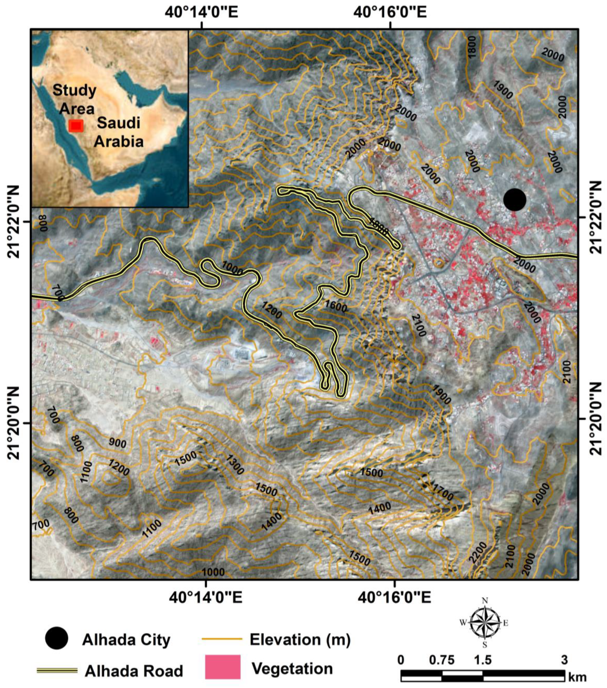
2.1. Study Area
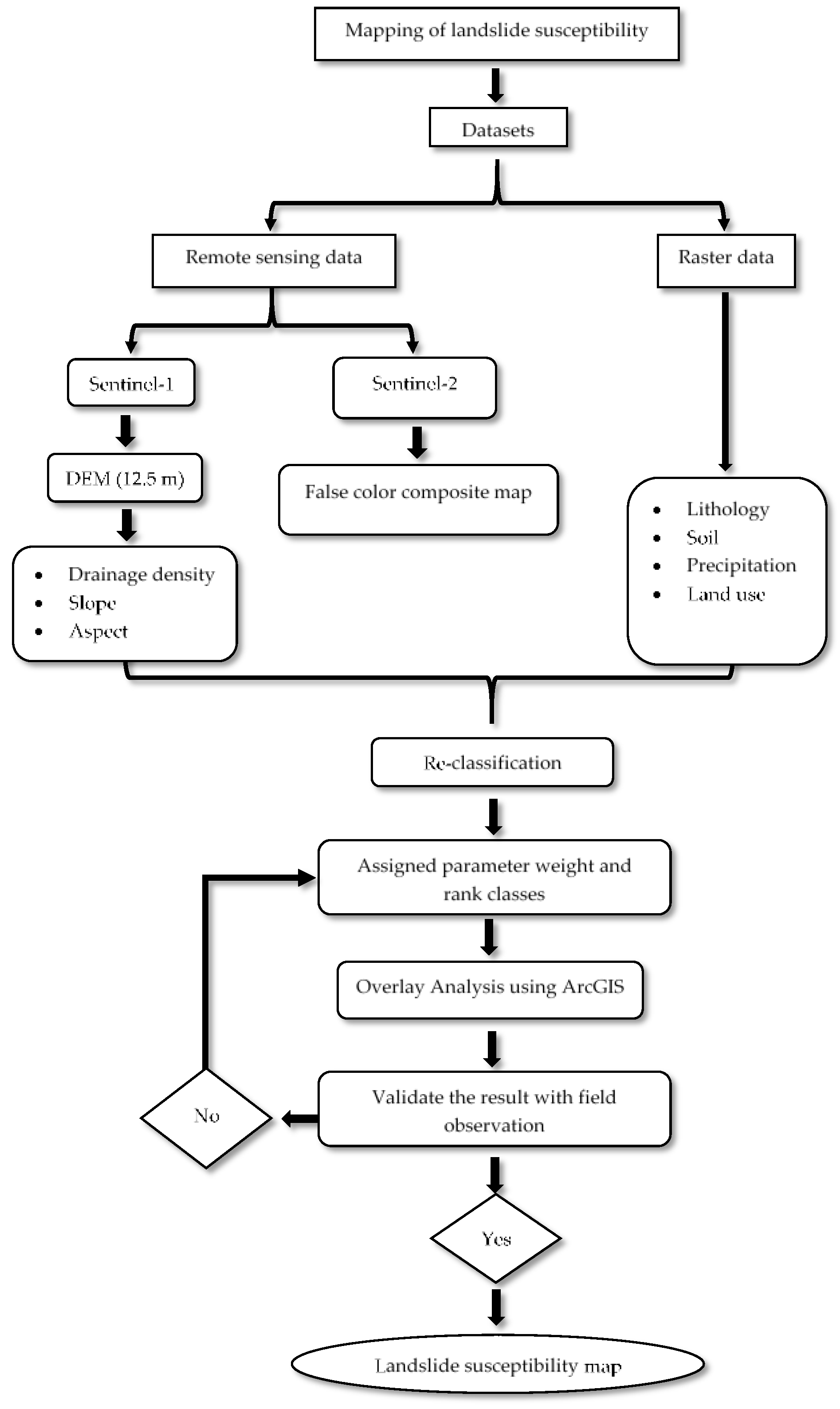
2.2. Datasets
3. Results
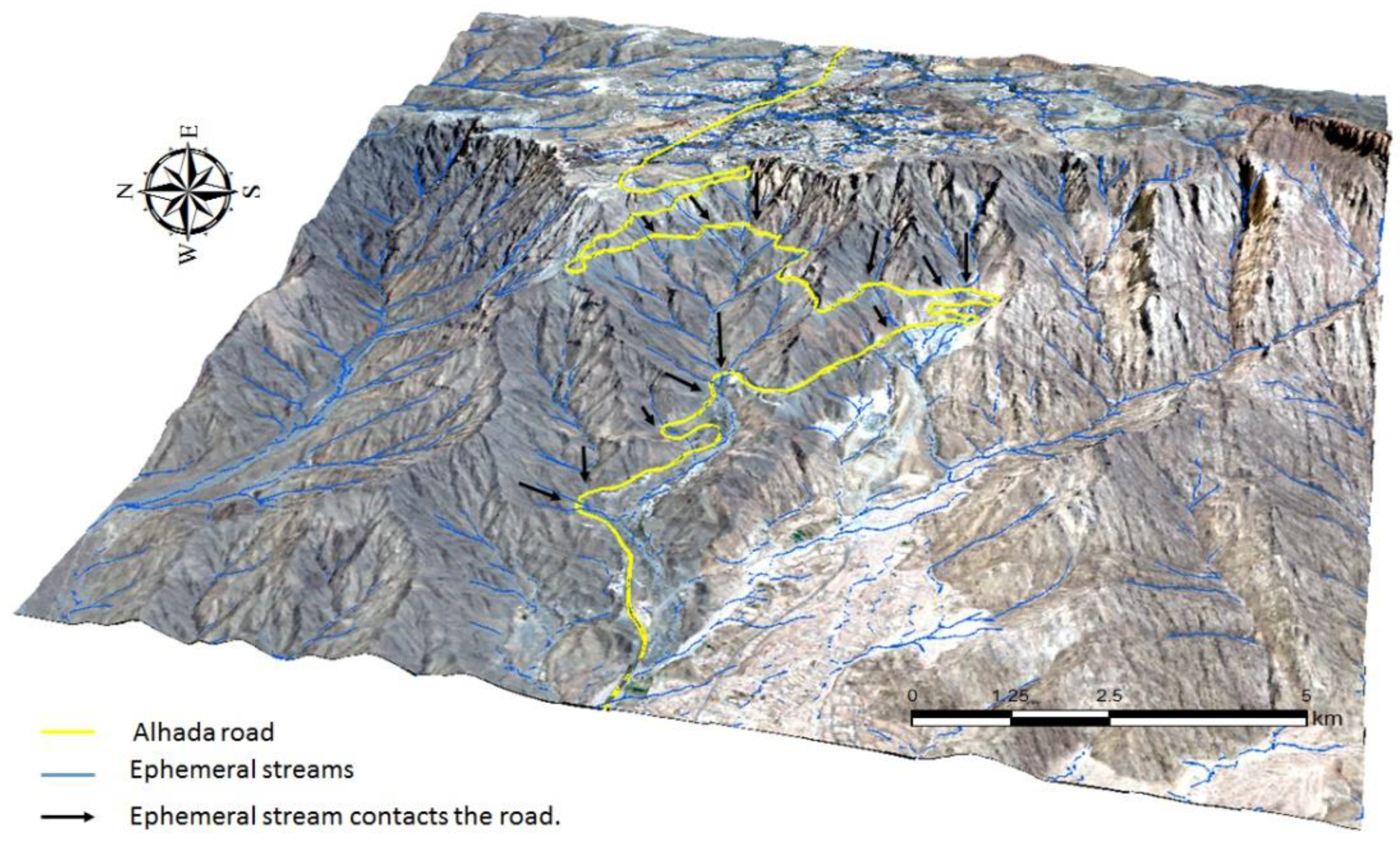
3.1. Drainage Density
3.2. Topography
3.3. Slope
3.4. Annual Precipitation
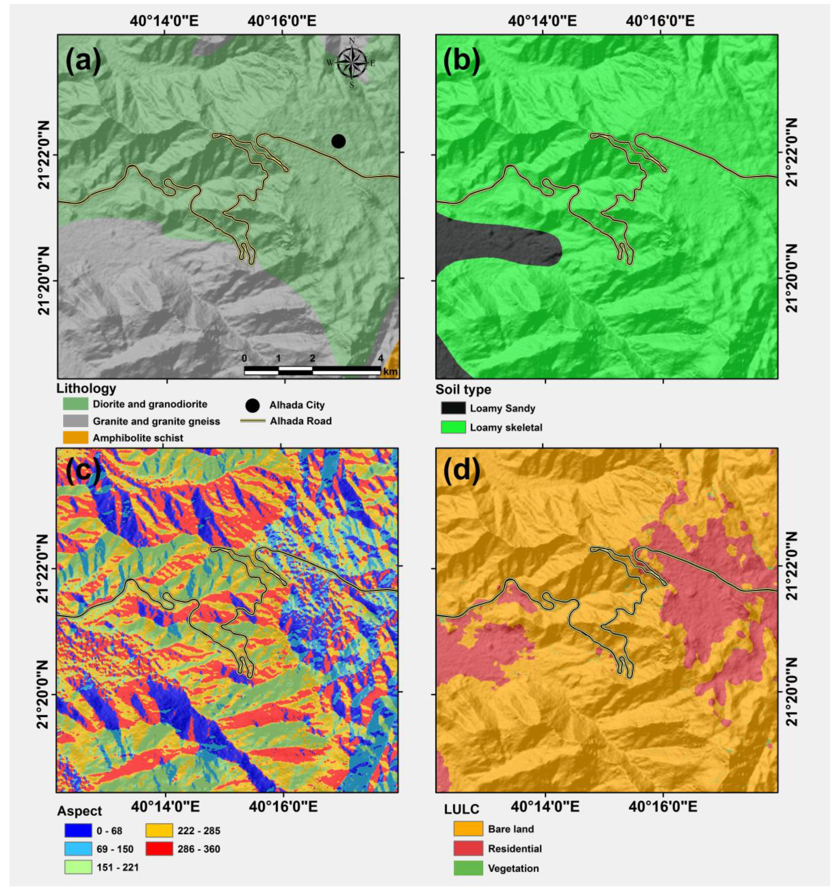
3.5. Lithology and Soil
3.6. Aspect
3.7. Land Use and Land Cover
4. Discussion
5. Conclusions
Author Contributions
Funding
Data Availability Statement
Acknowledgments
Conflicts of Interest
References
- Luo, H.Y.; Zhang, L.M.; Zhang, L.L.; He, J.; Yin, K.S. Vulnerability of buildings to landslides: The state of the art and future needs. Earth-Sci. Rev. 2023, 238, 104329. [Google Scholar] [CrossRef]
- Reichenbach, P.; Rossi, M.; Malamud, B.D.; Mihir, M.; Guzzetti, F. A review of statistically-based landslide susceptibility models. Earth-Sci. Rev. 2018, 180, 60–911. [Google Scholar] [CrossRef]
- Lacroix, P.; Handwerger, A.L.; Bièvre, G. Life and death of slow-moving landslides. Nat. Rev. Earth Environ. 2020, 1, 404–419. [Google Scholar] [CrossRef]
- Alharbi, T.; Sultan, M.; Sefry, S.; ElKadiri, R.; Ahmed, M.; Chase, R. An assessment of landslide susceptibility in the Faifa area, Saudi Arabia, using remote sensing and GIS techniques. Nat. Hazards Earth Syst. Sci. 2014, 14, 1553–1564. [Google Scholar] [CrossRef]
- Zhou, W.; Qiu, H.; Wang, L.; Pei, Y.; Tang, B.; Ma, S.; Yang, D.; Cao, M. Combining rainfall-induced shallow landslides and subsequent debris flows for hazard chain prediction. CATENA 2022, 213, 106199. [Google Scholar] [CrossRef]
- Qiu, H.; Zhu, Y.; Zhou, W.; Sun, H.; He, J.; Liu, Z. Influence of DEM resolution on landslide simulation performance based on the SCOOPS3D model. Geomat. Nat. Hazards Risk 2022, 13, 1663–1681. [Google Scholar] [CrossRef]
- Youssef, A.M.; Mahdi, A.M.; Al-Katheri, M.M.; Pouyan, S.; Pourghasemi, H.R. Multi-hazards (landslides, floods, and gully erosion) modeling and mapping using machine learning algorithms. J. Afr. Earth Sci. 2023, 197, 104788. [Google Scholar] [CrossRef]
- Sadagah, B. A vigorous debris-flow incident at Al-Hada descent and remedial measures. In Landslide Science for a Safer Geoenvironment; Sassa, K., Canuti, P., Yin, Y., Eds.; Springer: Berlin/Heidelberg, Germany, 2014; pp. 715–718. [Google Scholar]
- Youssef, A.M.; Pradhan, B.; Maerz, N.H. Debris flow impact assessment caused by 14 April 2012 rainfall along the Al-Hada Highway, Kingdom of Saudi Arabia using high-resolution satellite imagery. Arab. J. Geosci. 2014, 7, 2591–2601. [Google Scholar] [CrossRef]
- Alharbi, T. Mapping of groundwater, flood, and drought potential zones in neom, Saudi Arabia, using GIS and remote sensing techniques. Water 2023, 15, 966. [Google Scholar] [CrossRef]
- Casagli, N.; Intrieri, E.; Tofani, V.; Gigli, G.; Raspini, F. Landslide detection, monitoring and prediction with remote-sensing techniques. Nat. Rev. Earth Environ. 2023, 4, 51–64. [Google Scholar] [CrossRef]
- Shit, P.K.; Bhunia, G.S.; Maiti, R. Potential landslide susceptibility mapping using weighted overlay model (WOM). Model. Earth Syst. Environ. 2016, 2, 21. [Google Scholar] [CrossRef]
- Stüwe, K.; Robl, J.; Turab, S.A.; Sternai, P.; Stuart, F.M. Feedbacks between sea-floor spreading, trade winds and precipitation in the Southern Red Sea. Nat. Commun. 2022, 13, 5405. [Google Scholar] [CrossRef]
- Ma, S.; Qiu, H.; Zhu, Y.; Yang, D.; Tang, B.; Wang, D.; Wang, L.; Cao, M. Topographic changes, surface deformation and movement process before, during and after a rotational landslide. Remote Sens. 2023, 15, 662. [Google Scholar] [CrossRef]
- Hürlimann, M.; Coviello, V.; Bel, C.; Guo, X.; Berti, M.; Graf, C.; Hübl, J.; Miyata, S.; Smith, J.B.; Yin, H.Y. Debris-flow monitoring and warning: Review and examples. Earth-Sci. Rev. 2019, 199, 102981. [Google Scholar] [CrossRef]
- Alghamdi, A.G.; Aly, A.A.; Majrashi, M.A.; Ibrahim, H.M. Analysis of rockfall hazards along NH-15: A case study of Al-Hada road, Saudi Arabia. Geoenvironmental Disasters 2020, 7, 1. [Google Scholar]
- Almazroui, M.; Islam, M.N.; Alkhalaf, A.K.; Saeed, F. Spatiotemporal analysis of the annual rainfall in the Kingdom of Saudi Arabia. Theor. Appl. Climatol. 2021, 144, 1039–1054. [Google Scholar]
- Almazroui, M.; Islam, M.N.; Jones, P.D.; Athar, H.; Rahman, M.A. Recent climate change in the Arabian Peninsula: Seasonal rainfall and temperature climatology of Saudi Arabia for 1979–2009. Atmos. Res. 2012, 111, 29–45. [Google Scholar] [CrossRef]
- Shahabi, H.; Hashim, M. Landslide susceptibility mapping using GIS-based statistical models and Remote sensing data in tropical environment. Sci. Rep. 2015, 5, 9899. [Google Scholar] [CrossRef]
- Zhang, Q.; Ye, S.; Yan, F.; Ren, B. Application of RS & GIS in Regional Landslides Susceptibility Mapping and Spatiotemporal Characteristics Analysis. IOP Conf. Ser. Earth Environ. Sci. 2020, 428, 012093. [Google Scholar]
- Alkhasawneh, M.; Ngah, U.K.; Isa, N.A.M.; Pradhan, B.; Al-Batah, M.S.; Al-Amoush, H. GIS-based landslide susceptibility mapping and assessment using bivariate statistical models: A case study of Al-Hashimiya Qasabah, Zarqa Governorate, Jordan. Geoenviron. Disasters 2020, 7, 8. [Google Scholar]
- Chen, Y.; Yu, J.; Khan, S. Spatial sensitivity analysis of multi-criteria weights in GIS-based land suitability evaluation. Environ. Model. Softw. 2010, 25, 1582–1591. [Google Scholar] [CrossRef]
- Malczewski, J.; Rinner, C. (Eds.) Chapter 4: Weighted Linear Combination. In Multicriteria Decision Analysis in Geographic Information Science; Springer: Berlin/Heidelberg, Germany, 2015. [Google Scholar]
- Lin, P.; Pan, M.; Wood, E.F.; Yamazaki, D.; Allen, G.H. A new vector-based global river network dataset accounting for variable drainage density. Sci. Data 2021, 8, 28. [Google Scholar] [CrossRef] [PubMed]
- Yang, S.-Y.; Chang, C.-H.; Hsu, C.-T.; Wu, S.-J. Variation of uncertainty of drainage density in flood hazard mapping assessment with coupled 1D–2D hydrodynamics model. Nat. Hazards 2022, 111, 2297–2315. [Google Scholar] [CrossRef]
- Liu, C.; Wang, J.; Li, Z. A new method for estimating the potential energy of debris flows based on a two-phase flow model. Landslides 2019, 16, 1–14. [Google Scholar] [CrossRef]
- Hengl, T.; Reuter, H.I. (Eds.) Chapter 2: Digital Elevation Model Terminology. In Geomorphometry: Concepts, Software, Applications; Elsevier: Amsterdam, The Netherlands, 2009. [Google Scholar]
- Zhou, Q.; Liu, X. Analysis of errors of derived slope and aspect related to DEM data properties. Comput. Geosci. 2004, 30, 369–378. [Google Scholar] [CrossRef]
- Gabet, E.J.; Mudd, S.M. Bedrock erosion by root fracture and tree throw: A coupled biogeomorphic model to explore the humped soil production function and the persistence of hillslope soils. J. Geophys. Res. Earth Surf. 2010, 115, 4005–4019. [Google Scholar] [CrossRef]
- Larsen, I.J.; Montgomery, D.R. Landslide erosion coupled to tectonics and river incision. Nat. Geosci. 2012, 5, 468–473. [Google Scholar] [CrossRef]
- Sadagah, B. Rockfall Analysis, Modeling and Mitigation Along Al-Hada Descent Road, Saudi Arabia. In Engineering Geology for Society and Territory–Volume 2; Springer: Berlin/Heidelberg, Germany, 2015; pp. 1931–1935. [Google Scholar] [CrossRef]
- Borrelli, P.; Robinson, D.A.; Panagos, P.; Lugato, E.; Yang, J.E.; Alewell, C.; Wuepper, D.; Montanarella, L.; Ballabio, C. Land use and climate change impacts on global soil erosion by water (2015–2070). Proc. Natl. Acad. Sci. USA 2020, 117, 21994–22001. [Google Scholar] [CrossRef]
- Saravanan, S.; Thirumalaivasan, D. Assessment of Morphometric Parameters as the Basis for Hydrological Analysis of a River Basin Using GIS and Remote Sensing Techniques. ISPRS Int. J. Geo-Inf. 2020, 11, 459. [Google Scholar] [CrossRef]
- Song, X.-P.; Hansen, M.C.; Tyukavina, A.; Potapov, P.V.; Stehman, S.V.; Vermote, E.F.; Townshend, J.R.; Krylov, A.; Kommareddy, I.; Egorov, A. Global land change from 1982 to 2016. Nature 2018, 560, 639–643. [Google Scholar] [CrossRef]
- Fritz, S.; See, L.; McCallum, I.; You, L.; Bun, A.; Moltchanova, E.; Duerauer, M.; Albrecht, F.; Schill, C.; Perger, C.; et al. Mapping global cropland and field size. Glob. Chang. Biol. 2015, 21, 1980–1992. [Google Scholar] [CrossRef] [PubMed]
- Guo, Z.; Chen, L.; Yin, K.; Shrestha, D.P.; Zhang, L. Quantitative risk assessment of slow-moving landslides from the viewpoint of decision-making: A case study of the Three Gorges Reservoir in China. Eng. Geol. 2020, 273, 105667. [Google Scholar] [CrossRef]

| Parameter | Weight (%) | Classes | Rank |
|---|---|---|---|
| Slope (Degree) | 30 | 0–10 | 1 |
| 11–20 | 2 | ||
| 21–29 | 3 | ||
| 30–40 | 4 | ||
| 41–78 | 5 | ||
| Precipitation (mm) | 5 | 90.3–92.1 | 1 |
| 92.2–93.5 | 2 | ||
| 93.6–95 | 3 | ||
| 95.1–96.4 | 4 | ||
| 96.5–98.3 | 5 | ||
| Elevation (m) | 10 | 656–922 | 1 |
| 923–1181 | 2 | ||
| 1182–1460 | 3 | ||
| 1461–1799 | 4 | ||
| 1800–2336 | 5 | ||
| Lithology | 5 | Granite and granite gneiss | 3 |
| Amphibolite schist | 1 | ||
| Diorite and granodiorite | 2 | ||
| Drainage density (km2) | 35 | 0–1.07 | 1 |
| 1.08–1.97 | 2 | ||
| 1.98–2.9 | 3 | ||
| 2.91–3.87 | 4 | ||
| 3.88–6.21 | 5 | ||
| Soil | 5 | Loamy Sandy | 1 |
| Loamy-skeletal | 2 | ||
| Aspect | 5 | 0–68 (NE) | 1 |
| 69–150 (NE-SE) | 2 | ||
| 151–221 (SE-SW) | 3 | ||
| 222–285 (SW-NW) | 4 | ||
| 286–360 (NW) | 5 | ||
| Land use/land cover | 5 | Residential | 1 |
| Vegetation | 2 | ||
| Bare land | 3 |
Disclaimer/Publisher’s Note: The statements, opinions and data contained in all publications are solely those of the individual author(s) and contributor(s) and not of MDPI and/or the editor(s). MDPI and/or the editor(s) disclaim responsibility for any injury to people or property resulting from any ideas, methods, instructions or products referred to in the content. |
© 2023 by the authors. Licensee MDPI, Basel, Switzerland. This article is an open access article distributed under the terms and conditions of the Creative Commons Attribution (CC BY) license (https://creativecommons.org/licenses/by/4.0/).
Share and Cite
Alharbi, T.; El-Sorogy, A.S. Landslide Prediction in Mountainous Terrain Using Remote Sensing and GIS: A Case Study of Al-Hada Road, Makkah Province, Saudi Arabia. Water 2023, 15, 3771. https://doi.org/10.3390/w15213771
Alharbi T, El-Sorogy AS. Landslide Prediction in Mountainous Terrain Using Remote Sensing and GIS: A Case Study of Al-Hada Road, Makkah Province, Saudi Arabia. Water. 2023; 15(21):3771. https://doi.org/10.3390/w15213771
Chicago/Turabian StyleAlharbi, Talal, and Abdelbaset S. El-Sorogy. 2023. "Landslide Prediction in Mountainous Terrain Using Remote Sensing and GIS: A Case Study of Al-Hada Road, Makkah Province, Saudi Arabia" Water 15, no. 21: 3771. https://doi.org/10.3390/w15213771
APA StyleAlharbi, T., & El-Sorogy, A. S. (2023). Landslide Prediction in Mountainous Terrain Using Remote Sensing and GIS: A Case Study of Al-Hada Road, Makkah Province, Saudi Arabia. Water, 15(21), 3771. https://doi.org/10.3390/w15213771


