Mechanism Analysis and Process Inversion of the “7.26” Landslide in the West Open-Pit Mine of Fushun, China
Abstract
:1. Introduction
2. Overview of the “7.26” Landslide
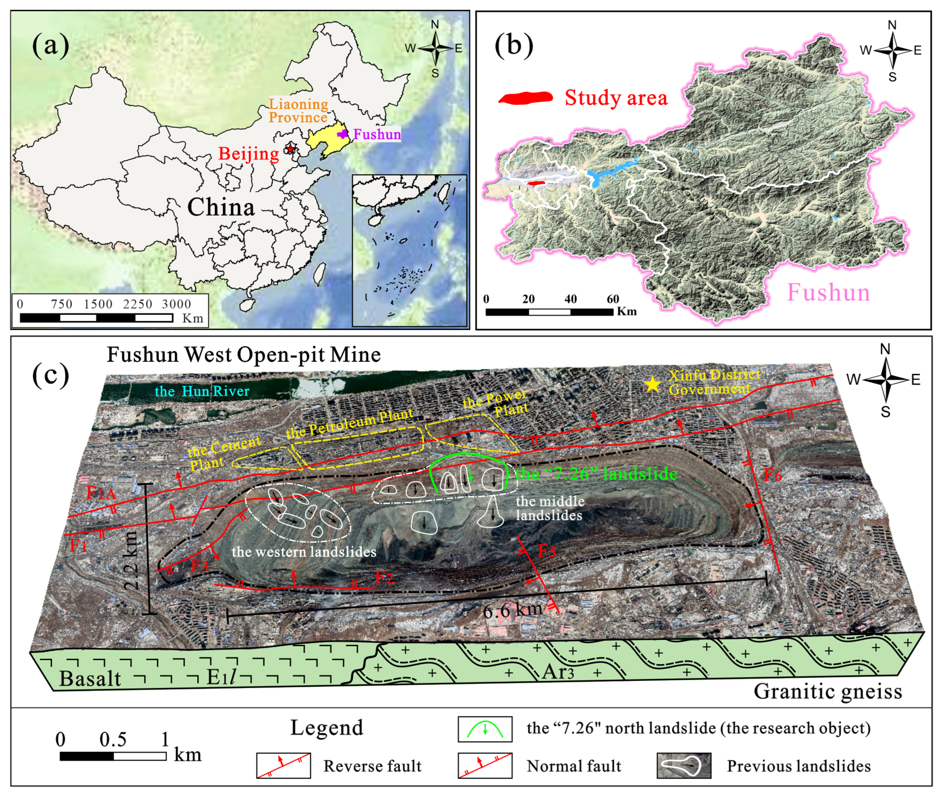
2.1. Geological Background of Landslide Occurrence
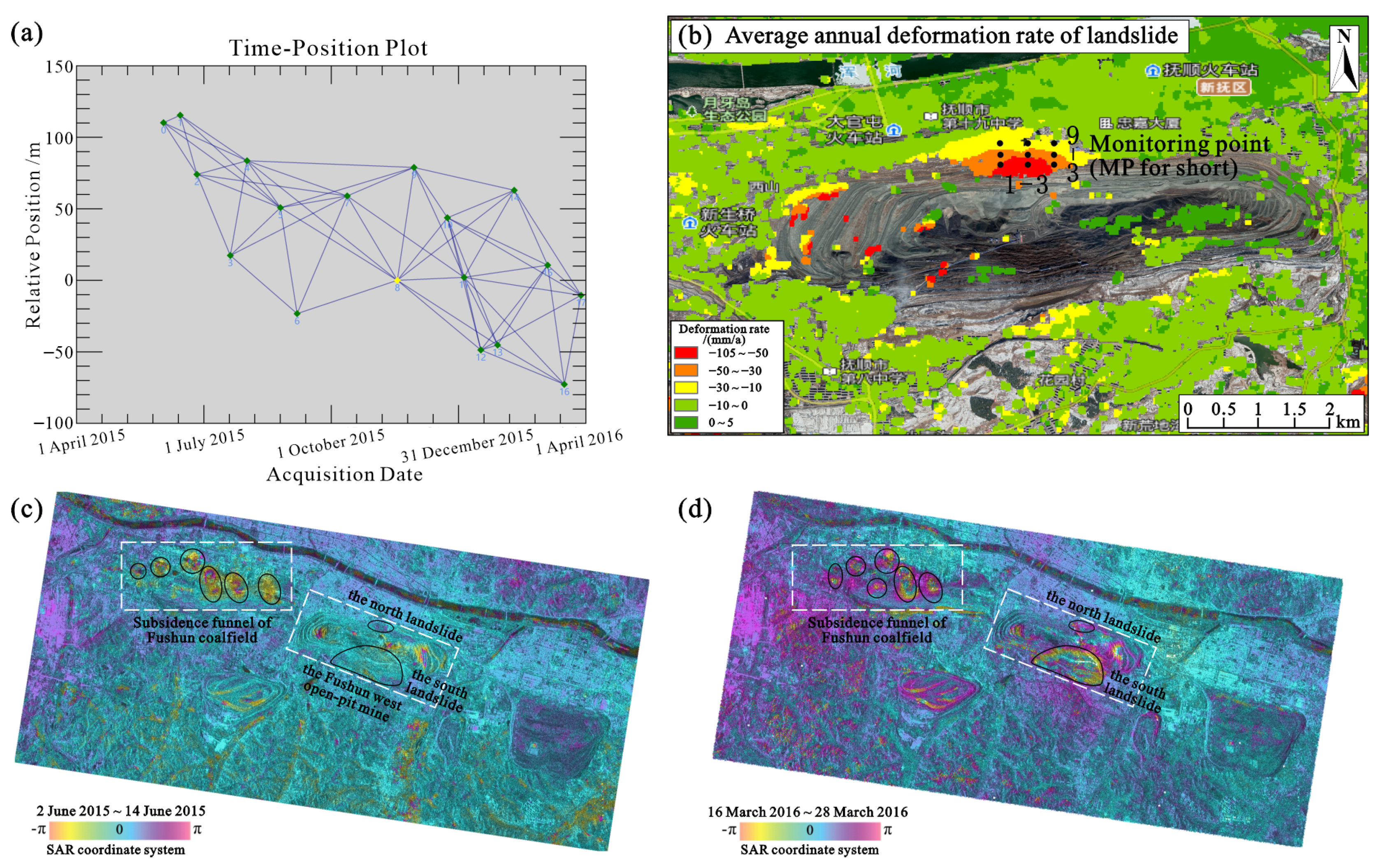
2.2. Deformation and Failure Characteristics of Landslide
3. Analysis of Landslide Mechanism
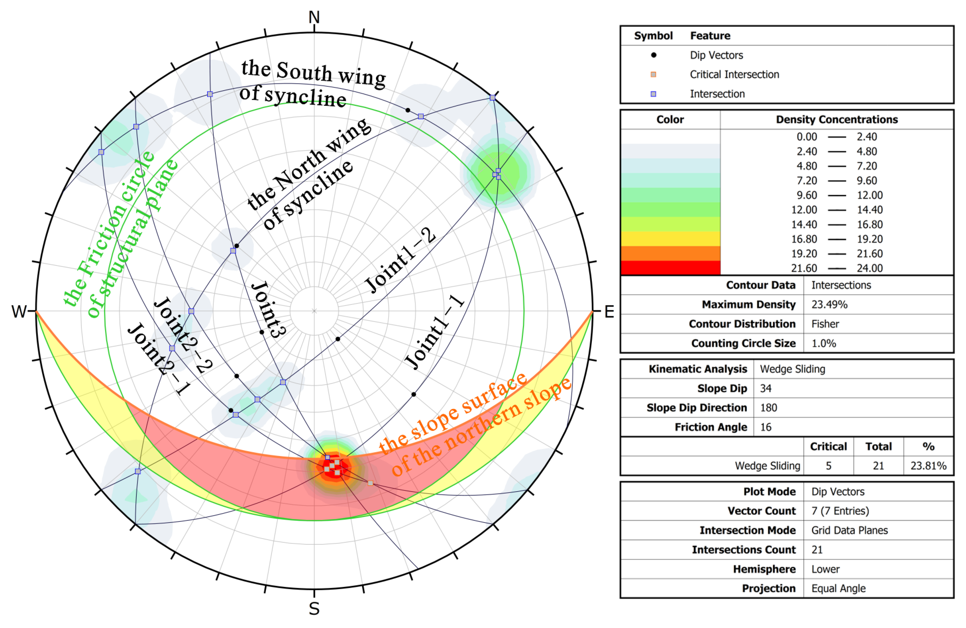
3.1. Control of Weak Structural Planes
3.2. Revival of Historical Landslides
3.3. Continuous Rainfall Promotes Sliding, Extreme Rainfall Triggers Landslides
4. Inversion of the Landslide Kinematic Process
4.1. Landslide Simulation and Model Validation
- Base friction model: Based on Ouyang et al. [22,23], the Coulomb friction model was selected to describe the objective of this study. The model is suitable for the simulation of debris flow disasters, such as landslides and rock collapses, and is expressed as follows.where τ is the foundation friction stress (kPa), c is the cohesive force (kPa), ρ is the density of the landslide mass (kg∙m−3), g is the gravitational acceleration (m∙s−2), h is the thickness of the landslide mass (m), λ is the pressure coefficient of the excess pore water, and φ is the internal friction angle (°).
- Physical and mechanical parameters of rock and soil mass: Based on the physical and mechanical test results of rock and soil in the landslide mass and landslide zone, and referring to the probability model of parameter selection based on uniform distribution by Zhou et al. [24], after several trial calculations, the parameters of the landslide simulation calculation were determined, as listed in Table 2.
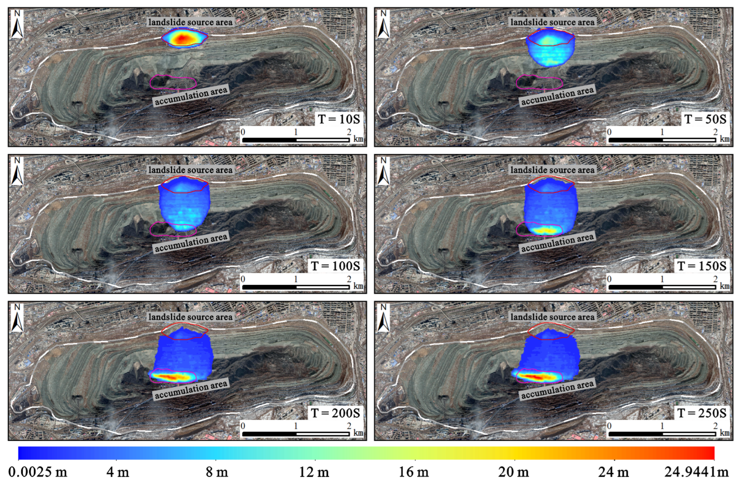
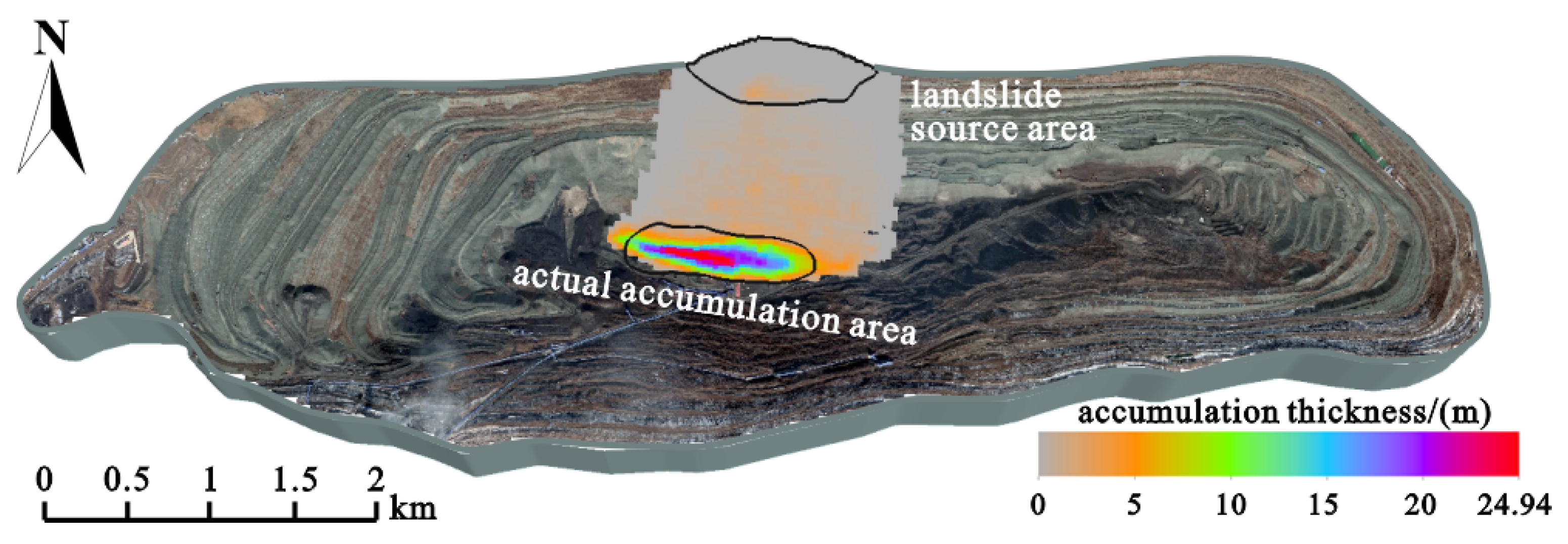
- Landslide source: Through field investigation, remote sensing interpretation, and comparative analysis of the 1:2000 geological profile of the north slope before and after the landslide, the plane range of the source area of the landslide was found to be approximately 201,620.9 m2, and the thickness of the landslide mass was approximately 0–44.7 m.
- Base topography: The base sliding bed topography was established using the ALSO-12.5 m DEM. The model was 6.6 km long and 2.2 km wide. Considering calculation accuracy and effectiveness, a range of approximately 2 km × 1.5 km in the middle of the mine was selected as the calculation area. A total of 83,250 structured grids were divided into 6 m intervals. The model was run for 250 s, and the calculation time step was limited to ΔT < 1 s.
4.2. Kinematic Process Analysis
- Landslide initiation stage
- 2
- Collision scraping stage
- 3
- Landslide accumulation stage

5. Discussion
- (a)
- Owing to long-term gravity and weathering, the old landslide mass at the top of the north slope was reactivated in late July 2015 and crept along two groups of controlled structural planes in the mudstone and shale formations. This corresponds to the weak deformation stage.
- (b)
- After the 2016 rainy season, continuous rainfall increased the uplift pressure and permeability of the cracks and decreased the strength of mudstone and shale. The tensile crack at the rear edge of the landslide accelerated, and a shear outlet formed at the front edge. This is the stage of strong deformation.
- (c)
- Until July 26, the mine suffered a once-in-50-year rainstorm. The cracks at the rear edge of the landslide were filled with water. The hydrostatic pressure at the rear edge was pointing out of the slope, and that of the seepage field inside the slope increased sharply. The sliding surface passed through. The old landslide mass at the top of the slope was destabilized. This is the stage of destabilization and destruction.
- (d)
- After the landslide occurred, the sliding mass was sheared from the front edge. The landslide mass in the middle and lower sections transformed into a debris flow along the slope. The debris scraped and shoveled the slope surface, causing damage and a downward step migration. The top of the north slope formed a circular chair-shaped landslide depression. When the high-speed part of the debris flow first reached the bottom of the pit, movement at the foot of the southern slope was hindered, and kinetic energy dissipated. The subsequent slow parts gradually arrived and accumulated at the bottom. Terrain with high middle and low east–west was initially formed at the bottom of the mine pit. The movement ended at this point. This is the stage of sliding accumulation.
6. Conclusions
- (a)
- The “7.26” landslide was caused by a weak structural plane, pre-existing old landslide mass, and seasonal rainfall. It gradually evolved from a steady state to destabilization in a certain sequence of main control. The rainy season of 2016 was used as the time boundary. The early stage was the reactivation of a wedge-shaped old landslide mass jointly controlled by the Hunhe Fault (F1) and the dominant joints of mudstone and shale. In the later stages, continuous rainfall accelerated the deformation of the landslide, causing a rainstorm-induced landslide event.
- (b)
- The movement process of the “7.26” landslide after destabilization can be divided into (1) the starting stage (0–10 s): the slope was unstable, and the landslide was cut from the front edge; (2) the stage of impact scraping (10–150 s): the landslide mass disintegrated after collision, turning into a debris flow and scraping the slope surface; and (3) the accumulation stage (150–250 s): arriving at the bottom of the pit, movement was blocked and gradually accumulated.
- (c)
- The entire disaster-causing process of the “7.26” landslide can be summarized as follows: (1) weak deformation stage: creep of an old landslide mass occurred along weak structural plane under gravity; (2) strong deformation stage: continuous rainfall gradually muddied the controlled structural plane, forming shear outlet; (3) instability and failure stage: triggered by rainstorm, the sliding surface was continuous, and the landslide mass became unstable; (4) sliding accumulation stage: the landslide mass transformed into debris flow along the slope surface and accumulated at the bottom of the pit.
Author Contributions
Funding
Data Availability Statement
Acknowledgments
Conflicts of Interest
References
- Froude, M.J.; Petley, D.N. Global fatal landslide occurrence from 2004 to 2016. Nat. Hazards Earth Syst. Sci. 2018, 18, 2161–2181. [Google Scholar] [CrossRef] [Green Version]
- Bobrowsky, P.T.; Brian, M. Encyclopedia of Engineering Geology, 1st ed.; Springer: Cham, Switzerland, 2018; pp. 579–580. [Google Scholar] [CrossRef]
- Karagianni, A.; Lazos, I.; Chatzipetros, A. Remote Sensing Techniques in Disaster Management: Amynteon Mine Landslides, Greece. In Proceedings of the Gi4DM: GeoInformation for Disaster Management Conference, Istanbul, Turkey, 18–21 March 2018. [Google Scholar] [CrossRef] [Green Version]
- López-Vinielles, J.; Ezquerro, P.; Fernández-Merodo, J.A.; Béjar-Pizarro, M.; Monserrat, O.; Barra, A.; Blanco, P.; García-Robles, J.; Filatov, A.; García-Davalillo, J.C.; et al. Remote analysis of an open-pit slope failure: Las Cruces case study. Spain. Landslides 2020, 17, 2173–2188. [Google Scholar] [CrossRef]
- Wei, Z.A.; Yin, G.Z.; Wan, L.; Shen, L.Y. Case history of controlling a landslide at Panluo open-pit mine in China. Environ. Geol. 2008, 54, 699–709. [Google Scholar] [CrossRef]
- Nie, L.; Li, Z.C.; Lv, Y.; Wang, H.F. A new prediction model for rock slope failure time: A case study in West Open-Pit mine, Fushun, China. Bull. Eng. Geol. Environ. 2017, 76, 975–988. [Google Scholar] [CrossRef]
- Zhang, F.; Yang, T.H.; Li, L.C.; Zhu, X.P. Investigation on the Reinforcement Effect of a Bedding Slope Affected by a Landsliding Block. Arab. J. Geosci. 2022, 15, 528. [Google Scholar] [CrossRef]
- An, B.; Zhu, C.; Liu, K.M.; Li, S.T.; Tao, Z.G.; Li, H.P.; Yu, H.R. he Influence of Rainfall on Landslide Stability of an Open-Pit Mine: The Case of Haizhou Open-Pit Mine. Geotech. Geol. Eng. 2019, 37, 3367–3378. [Google Scholar] [CrossRef]
- Kang, K.; Fomenkp, I.K.; Wang, J.; Nikolskaya, O.V. Probabilitistic Assessment of Rock Slope Stability in Open Pit Mine Chaarat using the Generalized Hoke-Brown Criterion. J. Min. Sci. 2020, 56, 732–740. [Google Scholar] [CrossRef]
- Troncone, E.; Conte, E.; Donato, A. Two and three-dimensional numerical analysis of the progressive failure that occurred in an excavation-induced landslide. Eng. Geol. 2014, 183, 265–275. [Google Scholar] [CrossRef]
- Dhahri, F.; Benassi, R.; Mhamdi, A.; Zeyeni, K.; Boukadi, N. Structural and geomorphological controls of the present-day landslide in the Moulares phosphate mines (western-central Tunisia). Bull. Eng. Geol. Environ. 2016, 75, 1459–1468. [Google Scholar] [CrossRef]
- Sun, S.-W.; Pang, B.; Hu, J.-B.; Yang, Z.X.; Zhong, X.Y. Characteristics and mechanism of a landslide at Anqian iron mine, China. Landslides 2021, 18, 2593–2607. [Google Scholar] [CrossRef]
- Sun, G.M.; Hu, G.J.; Xiao, P.; Wang, X.F. Study on strength calculation and quality grading of slope rock in Fushun West Open Pit Mine. Coal Sci. Technol. 2017, 45, 36–41, 63. (In Chinese) [Google Scholar] [CrossRef]
- Gao, B. North Slope Landslide Analysis and Control Research in Fushun West Open-pit Mine. Opencast Min. Technol. 2017, 32, 14–16, 20. (In Chinese) [Google Scholar] [CrossRef]
- Segomo, S.; Piciullo, L.; Gariano, S.L. A review of the recent literature on rainfall thresholds for landslide occurrence. Landslides 2018, 15, 1483–1501. [Google Scholar] [CrossRef]
- Liu, D.Y.; Wang, E.D.; Song, J.C.; Zhang, C.S. The Relation between Landslide and Rainfall and Prediction Method of Western Open-pit Coal Mine of Fushun. J. Catal. 2008, 23, 50–54. (In Chinese) [Google Scholar] [CrossRef]
- Bossi, G.; Zabuski, L.; Pasuto, A.; Marcato, G. Capabilities of Continuous and Discontinuous Modelling of a Complex, Structurally Controlled Landslide. Geotech. Geol. Eng. 2016, 34, 1677–1686. [Google Scholar] [CrossRef]
- Ji, Y.S.; (China Coal Technology & Engineering Group Shenyang Research Institute, Shenyang, China); Shen, L.; (China Coal Technology & Engineering Group Shenyang Research Institute, Shenyang, China); Liu, J.H.; (China Coal Technology & Engineering Group Shenyang Research Institute, Shenyang, China). Personal communication: Surface Stability Evaluation of Fushun No.1 Petroleum Plant, Power Plant and Cement Plant, 2015. (In Chinese).
- Sun, S.W.; Liu, L.; Hu, J.B.; Ding, H. Failure characteristics and mechanism of a rain-triggered landslide in the northern longwall of Fushun west open pit, China. Landslides 2022, 19, 2439–2458. [Google Scholar] [CrossRef]
- Cui, Q.; Zhang, L.; Chen, X.; Cao, Z.J.; Zhang, J.; Xu, J.B.; Liu, D.S.; Du, C.L. Quantitative risk assessment of landslides with direct simulation of pre-failure to post-failure behaviors. Acta Geotech. 2022, 17, 4497–4514. [Google Scholar] [CrossRef]
- Iverson, R.M.; Ouyang, C.J. Entrainment of bed material by Earth-surface mass flows: Review and reformulation of depth-integrated theory. Rev. Geophys. 2015, 53, 27–58. [Google Scholar] [CrossRef]
- Ouyang, C.J.; He, S.M.; Xu, Q.; Luo, Y.; Zhang, W.C. A MacCormack-TVD finite difference method to simulate the mass flow in mountainous terrain with variable computational domain. Comput. Geosci. 2013, 52, 1–10. [Google Scholar] [CrossRef]
- Ouyang, C.J.; An, H.C.; Zhou, S.; Wang, Z.W.; Su, P.C.; Wang, D.P.; Cheng, D.X.; She, J.X. Insights from the failure and dynamic characteristics of two sequential landslides at Baige village along the Jinsha River, China. Landslides 2019, 16, 1397–1414. [Google Scholar] [CrossRef]
- Zhou, Q.; Xu, Q.; Peng, D.L.; Fan, X.M.; Ouyang, C.J.; Zhao, K.Y.; Li, H.J.; Zhu, X. Quantitative spatial distribution model of site-specific loess landslides on the Heifangtai terrace, China. Landslides 2021, 18, 1163–1176. [Google Scholar] [CrossRef]
- Scaringi, G.; Fan, X.M.; Xu, Q.; Liu, C.; Ouyang, C.J.; Domènech, G.; Yang, F.; Dai, L.X. So me considerations on the use of numerical methods to simulate past landslides and possible new failures: The case of the recent Xinmo landslide (Sichuan, China). Landslides 2018, 15, 1359–1375. [Google Scholar] [CrossRef]
- Gao, Y.; Yin, Y.P.; Li, B.; Feng, Z.; Wang, W.P.; Zhang, N.; Xing, A.G. Characteristics and numerical runout modeling of the heavy rainfall-induced catastrophic landslide–debris flow at Sanxicun, Dujiangyan, China, following the Wenchuan Ms 8.0 earthquake. Landslides 2017, 14, 1361–1374. [Google Scholar] [CrossRef]




| Number of Joint Groups | Occurrence | Joint Density (bar∙m−1) |
|---|---|---|
| Joint group 1 | 130–145° ∠ 40–75° | 3–5 |
| Joint group 2 | 220–230° ∠ 40–50° | 1–2 |
| Joint group 3 | 248° ∠ 67° | 1–3 |
| Density of Landslide Mass (ρ) | Internal Friction Angle (φ) | Cohesive Force (c) | Pressure Coefficient of Excess Pore Water (λ) | Gravitational Acceleration (g) |
|---|---|---|---|---|
| 2250 kg∙m−3 | 16.0° | 85 kPa | 0.75 | 9.8 m∙s−2 |
| The “7.26” Landslide | Simulated Calculation Value | Survey Values | Pressure Coefficient of Excess Pore Water (%) |
|---|---|---|---|
| Accumulate area (m2) | 219,562.15 | 187,105.72 | 17.35 |
| Maximum thickness of accumulation (m) | 24.94 | 28.35 | 12.02 |
Disclaimer/Publisher’s Note: The statements, opinions and data contained in all publications are solely those of the individual author(s) and contributor(s) and not of MDPI and/or the editor(s). MDPI and/or the editor(s) disclaim responsibility for any injury to people or property resulting from any ideas, methods, instructions or products referred to in the content. |
© 2023 by the authors. Licensee MDPI, Basel, Switzerland. This article is an open access article distributed under the terms and conditions of the Creative Commons Attribution (CC BY) license (https://creativecommons.org/licenses/by/4.0/).
Share and Cite
Meng, H.; Wu, J.; Zhang, C.; Wu, K. Mechanism Analysis and Process Inversion of the “7.26” Landslide in the West Open-Pit Mine of Fushun, China. Water 2023, 15, 2652. https://doi.org/10.3390/w15142652
Meng H, Wu J, Zhang C, Wu K. Mechanism Analysis and Process Inversion of the “7.26” Landslide in the West Open-Pit Mine of Fushun, China. Water. 2023; 15(14):2652. https://doi.org/10.3390/w15142652
Chicago/Turabian StyleMeng, Huajun, Jihuan Wu, Chunshan Zhang, and Kungang Wu. 2023. "Mechanism Analysis and Process Inversion of the “7.26” Landslide in the West Open-Pit Mine of Fushun, China" Water 15, no. 14: 2652. https://doi.org/10.3390/w15142652


