


Bengal Delta, Charland Formation, and Riparian Hazards: Why Is a Flexible Planning Approach Needed for Deltaic Systems?


Abstract
1. Introduction
2. Methods
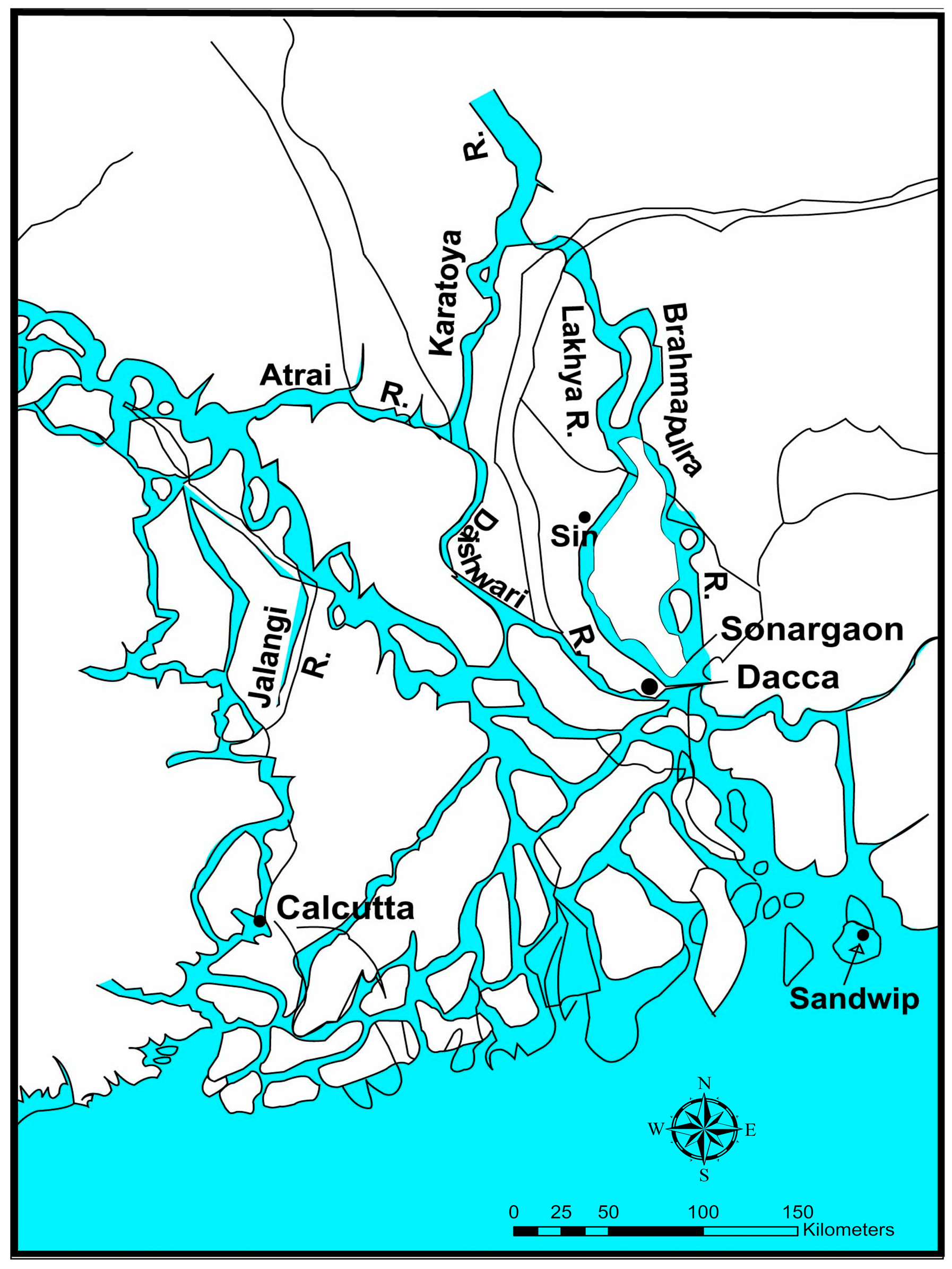
2.1. Study Area
2.2. Sources of Data and Survey Methods
2.3. Data Analysis
3. Dynamic Bengal Delta and Charland Formation and Its Associated Hazards
3.1. Morphology of Bengal Delta Formation
3.2. Fluvial-Riverine Systems
3.3. River Channel Patterns and Charland Formation
3.4. Charland Temporal Cycles
3.5. Channel Shifting and Bank Erosion

4. The State, the Permanent Settlement Scheme, and Administration of Alluvion and Diluvion Regulation
Post-Independence (1971) Land Reforms
5. Contemporary Land Management Policies Relevant to Charland Inhabitants
5.1. Contemporary Land Laws and Regulations
State policies and their implementation, particularly in the countryside, continue to be plagued by various forms of corruption and an elite and bureaucratic formation that has been unable to mediate—and in fact, takes advantage of—the costs of neoliberal reforms that have privatized and decentralized form of rule that were once part of local systems of accountability.
5.2. Regulations on Land Use, Acquisitions and Resettlement
6. Coping and Adaptations to Environmental Risks in Charlands
6.1. The Kazipur Charland of the Jamuna-Brahmaputra River System: A Case Study
6.2. The Shibchar Upazila of the Ganges-Padma River System: A Case Study
7. Discussion
8. Conclusions
Author Contributions
Funding
Institutional Review Board Statement
Data Availability Statement
Acknowledgments
Conflicts of Interest
References
- Alam, M.M.; Curray, J.R. The curtain goes up on a sedimentary basin in south-central Asia: Unveiling the sedimentary geology of the Bengal Basin of Bangladesh. Sediment. Geol. 2003, 155, 175–178. [Google Scholar] [CrossRef]
- Akter, J.; Sarker, M.H.; Popescu, I.; Roelvink, D. Evolution of the Bengal Delta and its prevailing processes. J. Coast. Res. 2016, 32, 1212–1226. [Google Scholar] [CrossRef]
- Sarker, M.H.; Huque, I.; Alam, M.; Koudstaal, R. Rivers, chars and char dwellers of Bangladesh. Int. J. River Basin Manag. 2003, 1, 61–80. [Google Scholar] [CrossRef]
- Mukerjee, R. The Changing Face of Bengal: A Study in Riverine Economy; Calcutta University Press: Calcutta, India, 1938. [Google Scholar]
- Nicholas, R.W. Villages of the Bengal Delta: A Study of Ecology and Peasant Society. Ph.D. Thesis, University of Chicago, Chicago, IL, USA, 1962. Unpublished. [Google Scholar]
- Zaman, M.Q. The social and political context of adjustment to riverbank erosion hazard and population resettlement in Bangladesh. Hum. Organ. 1989, 48, 196–205. [Google Scholar] [CrossRef]
- Haque, C.E. Hazards in a Fickle Environment: Bangladesh; Kluwer Academic Publishers: Dordrecht, The Netherlands, 1997. [Google Scholar]
- Brammer, H. Can Bangladesh be Protected from Floods? The University Press Ltd.: Dhaka, Bangladesh, 2004. [Google Scholar]
- Islam, S.; Moula, G.; Islam, M. Land rights, land disputes and land administration in Bangladesh—A critical study. Beijing Law Rev. 2015, 6, 193–198. [Google Scholar] [CrossRef]
- ISPAN (Irrigation Support Project for Asia, near East). The Dynamic Physical Environment of Riverine Charlands: Brahmaputra-Jamuna; ISPAN: Dhaka, Bangladesh, 1995. [Google Scholar]
- Coleman, J.M. Brahmaputra River: Channel processes and sedimentation. Sediment. Geol. 1969, 3, 129–239. [Google Scholar] [CrossRef]
- Stene, L.P.; Haque, C.E. Jamuna bankline behaviour, 1972–1984. In Proceedings of the International Symposium on the Impact of Riverbank Erosion, Flood Hazards, and the Problem of Polulation Displacement, Dhaka, Bangladesh, 11–14 April 1988. [Google Scholar]
- Goodbred, S.L., Jr.; Kuehl, S.A.; Steckler, M.S.; Sarker, M.H. Controls on facies distribution and stratigraphic preservation in the Ganges-Brahmaputra delta sequence. Sediment. Geol. 2003, 155, 301–316. [Google Scholar] [CrossRef]
- Morgan, J.P.; McIntire, W.G. Quaternary geology of the Bengal basin, East Pakistan and India. Bull. Geol. Soc. Am. 1959, 70, 319–342. [Google Scholar] [CrossRef]
- Poddar, M.C. Preliminary report of the Assam earthquake, 15th August, 1950. Bull. Geol. Soc. India 1952, 2, 11–13. [Google Scholar]
- Fergusson, J. On recent changes in the delta of the Ganges. Q. J. Geol. Soc. Lond. 1863, 19, 321–354. [Google Scholar] [CrossRef]
- Brammer, H. The Geography of the Soils of Bangladesh; The University Press Ltd.: Dhaka, Bangladesh, 1996. [Google Scholar]
- Curray, F.C.; Moore, D.G. Growth of the Bengal deep sea fan and dunudation in the Himalayas. Geol. Soc. Am. Bull. 1971, 82, 63–572. [Google Scholar] [CrossRef]
- Spate, O.H.K. India and Pakistan: A General and Regional Geography; E.P. Dutton & Co.: New York, NY, USA, 1954. [Google Scholar]
- Rashid, H.E. Geography of Bangladesh; University Press Ltd.: Dhaka, Bangladesh, 1977. [Google Scholar]
- Ahmed, N. An Economic Geography of East Pakistan; Oxford University Press: London, UK, 1968. [Google Scholar]
- Leopold, L.B.; Wolman, M.G. River channel patters—Braided, meandering and straight. United States Geol. Surv. Prof. Pap. 1957, 282-B, 85. [Google Scholar]
- Ackers, P.; Charlton, F.G. The slope and resistance of small meandering channels. Proc. Inst. Civ. Eng. 1970, 47 (Suppl. 7362-S), 349–370. [Google Scholar]
- Sarker, M.H.; Thorne, C.R.; Akter, M.N.; Ferdous, M.R. Morpho-dynamics of the Brahmaputra-Jamuna River, Bangladesh. Geomorphology 2014, 215, 45–59. [Google Scholar] [CrossRef]
- Rahman, S. The Brahmaputra Right Bank Flood Embankment: Its Problems and Probable Solutions; Water Development Board: Rajshahi, Bangladesh, 1984. [Google Scholar]
- Knighton, A.D. Fluvial Forms and Processes; Edward Arnold: London, UK, 1984. [Google Scholar]
- Zaman, M.; Alam, M. The delta frontiers: History and dynamics. In Living on the Edge: Char Dwellers in Bangladesh; Zaman, M., Alam, M., Eds.; Springer: Cham, Switzerland, 2021; pp. 15–24. [Google Scholar]
- Roy, K.C. Char land agriculture. Daily Sun, 21 July 2019. [Google Scholar]
- Haque, C.E.; Jakariya, M. Dynamic land and adaptive people of Bengal Basin and its charland. In Living on the Edge—Char Dwellers in Bangladesh; Zaman, M., Alam, M., Eds.; Springer: Cham, Switzerland, 2021; pp. 41–56. [Google Scholar]
- ISPAN. The Dynamic Physical and Human Environment of the Riverine Charlands and Charland; Socioeconomic RRA Reports for the Brahmaputra-Jamuna, Meghna, Ganges and Padma rivers, and the Charland Flood Proofing Study. Prepared for Flood Action Plan Coordination Organization. ISPAN Irrigation Support Project for Asia and the Near East; ISPAN: Dhaka, Bangladesh, 1995. [Google Scholar]
- CEGIS (Center for Environmental, Geographic Information Services). Impact of Climate Change on the Morphological Processes of Main Rivers and Meghna Estuary of Bangladesh; Prepared for Asian Development Bank; CEGIS: Dhaka, Bangladesh, 2010. [Google Scholar]
- Galey, V.J. River channel shifting on large rivers in Bangladesh. In Proceedings of the International Symposium on River Sedimentation, Beijing, China, 1 March 1980. [Google Scholar]
- Tarafdar, M.R. Development of water resources in the deltaic areas of Bangladesh. In Proceedings of the 3rd Regional Symposium on the Development of Deltaic Areas; UN Warer Resources Series No. 50. United Nations: New York, NY, USA, 1978; pp. 162–169. [Google Scholar]
- ISPAN (Irrigation Support Project for Asia and Near East). ISPAN Char Study—Jamuna Inventory; Flood Action Plan: Dhaka, Bangladesh, 1993. [Google Scholar]
- Thorne, C.R. Progress and mechanisms of river bank erosion. In Gravel-bed Rivers: Fluvial Process, Engineering and Management; Hey, R.D., Bathurst, J.C., Thorne, C.R., Eds.; Wiley: Chichester, UK, 1982; pp. 227–259. [Google Scholar]
- China-Bangladesh Joint Expert Team (CBJET). Study Report on Flood Control and River Training Project on the Brahmaputra River in Bangladesh, Vol. 1. Analysis and Hydrology and River Morphology of the Brahmaputra River; CBJET: Dhaka, Bangladesh.
- Stokes, E. The Peasant and the Raj: Studies in Agrarian Society and Peasant Revolution in Colonial India; Vikas Publishing House: Delhi, India, 1978. [Google Scholar]
- Zaman, M.Q. Endemic land conflict and violence in char villages in Bangladesh. East. Anthropol. 1987, 40, 1–9. [Google Scholar]
- Gupta, R.M.N. Land System of Bengal; University of Calcutta Press: Calcutta, India, 1940. [Google Scholar]
- Ali, S.M. Administration of charland in Bangladesh. Asian Aff. 1980, 2, 259–303. [Google Scholar]
- Haque, C.E. Introduction: The need for a focus on the political economy of Bangladesh. In Bangladesh: Politics, Economy and Society; Haque, C.E., Ed.; Bangladesh Studies Assemblage, University of Manitoba: Winnipeg, MB, Canada, 1987; pp. 1–14. [Google Scholar]
- Abdullah, A. The peasant economy in transition: The rise of rich peasants in permanently settled Bengal. Bangladesh Dev. Stud. 1980, 8, 1–20. [Google Scholar]
- Zaman, M.Q. Social structure and process in Charland settlement in the Brahmaputra-Jamuna floodplain. Man 1991, 26, 673–690. [Google Scholar] [CrossRef]
- Malik, S. Land reclamation. Bangladesh Today 1983, 1, 25–28. [Google Scholar]
- Zaman, M.; Hossain, M.A. The charland administration and governance: Need for a paradigm change. In Living on the Edge—Char Dwellers in Bangladesh; Zaman, M., Alam, M., Eds.; Springer: Cham, Switzerland, 2021; pp. 403–414. [Google Scholar]
- Hossain, M. Improving Land Administration and Management in Bangladesh; Bangladesh Institute of Development Studies (BIDS): Dhaka, Bangladesh, 2015. [Google Scholar]
- Masum, F. Rural land management in Bangladesh: Problems and prospects. Geomat. Landmanag. Landsc. 2017, 4, 79–93. [Google Scholar] [CrossRef]
- Tariquzzaman, S.; Rana, S. Understanding the Effectiveness of Access to Khas Land: Comparing Khas Land Receivers to Non-Receiver; Shiree Working Paper No. 24; Uttaran: Dhaka, Bangladesh, 2014. [Google Scholar]
- Feldman, S.; Geisler, C. Land grabbing in Bangladesh: In-situ displacement of peasant holdings. In Proceedings of the International Conference on Global Land Grabbing, University of Sussex, Sussex, UK, 6–8 April 2011. [Google Scholar]
- Zaman, M.Q. Development and displacement in Bangladesh: Toward a resettlement policy. Asian Surv. 1996, 36, 691–703. [Google Scholar] [CrossRef]
- CARE. Land Policy and Administration in Bangladesh: A Literature Review; CARE SDU Reports and Studies; CARE: Dhaka, Bangladesh, 2003. [Google Scholar]
- Haque, C.E. Human adjustments to river bank erosion hazard in the Jamuna floodplain, Bangladesh. Hum. Ecol. 1989, 16, 421–437. [Google Scholar] [CrossRef]
- Haque, C.E.; Zaman, M.Q. Coping with riverbank erosion hazard and displacement in Bangladesh: Survival strategies and adjustments. Disasters J. Disaster Stud. Manag. 1990, 13, 309–323. [Google Scholar] [CrossRef] [PubMed]
- Hutton, D.; Haque, C.E. Pattern of coping and adaptation among erosion-induced displaces in Bangladesh: Implications for hazard analysis and mitigation. Nat. Hazards 2003, 29, 405–421. [Google Scholar] [CrossRef]
- Haque, C.E.; Zaman, M.Q. Human responses to riverine hazards in Bangladesh: A proposal for sustainable floodplain development. World Dev. 1993, 21, 93–107. [Google Scholar] [CrossRef]
- Welle, T.; Birkmann, J. The World Risk Index—An approach to assess rick and vulnerability on a global scale. J. Extrem. Events 2015, 2, 1550003. [Google Scholar] [CrossRef]
- Zaman, M.Q.; Haque, C.E. Working together: Reflections on collaborative research in Bangladesh. Can. J. Dev. Stud. 1991, 12, 387–403. [Google Scholar] [CrossRef]
- Paul, B.K. Perception of and agricultural adjustments to floods in Jamuna floodplain, Bangladesh. Hum. Ecol. 1984, 12, 3–19. [Google Scholar] [CrossRef]
- Rasid, H.; Paul, B.K. Flood problems in Bangladesh: Is there an indigenous solution? Environ. Manag. 1987, 11, 155–173. [Google Scholar] [CrossRef]
- Islam, M.S.; Sultana, S.; Saifunnahar, M.; Miah, M.A. Adaptation of char livelihood in flood and river erosion areas through Indigenous practice: A study on Bhuapur riverine area in Tangail. J. Environ. Sci. Nat. Resour. 2014, 7, 13–19. [Google Scholar] [CrossRef]
- Wallace, A.F.C. Mazeway disintegration: The individual’s perception of socio-cultural disintegration. Hum. Organ. 1957, 16, 23–27. [Google Scholar] [CrossRef]
- Oliver-Smith, A. Here there is a life: The social and cultural dynamics of successful resistance to resettlement in postdisaster Peru. In Involuntary Migration and Resettlement; Hansen, A., Oliver-Smith, A., Eds.; Westview Press: Boulder, CO, USA, 1982; pp. 85–103. [Google Scholar]
- Rahman, M.S.; Chowdhury, F. Investment and Financing Strategy for Coastal Zone Development in Bangladesh, Working Paper WP037; Program Development Office for Integrated Coastal Zone Management Plan: Dhaka, Bangladesh, 2005.
- WARPO (Water Resources Planning Organization). Coastal Development Strategy; Ministry of Water Resources, Government of the People’s Republic of Bangladesh: Dhaka, Bangladesh, 2006.
- Transparency International. Corruption Perceptions Index 2017. Available online: www.transparency.org (accessed on 6 March 2018).
- Bhattacharya, S.; Dunn, P.; Thomas, C.G.; Smith, B.; Schaefer, H.; Chen, J.; Hu, Z.; Zalocusky, K.A.; Shankar, R.D.; Shen-Orr, S.S.; et al. ImmPort, toward repurposing of open access immunological assey data for translational and clinical research. Sci. Data 2018, 5, 1800015. [Google Scholar] [CrossRef] [PubMed]
- Numan, M.; Mahabubul, A. Environmental policy of Bangladesh: A critical review on implementation scenario. Dyn. Public Adm. 2021, 38, 129–145. [Google Scholar]
- The Ministry of Land. National Land Use Policy 2001, Peoples’ Republic of Bangladesh; Government of the People’s Republic of Bangladesh: Dhaka, Bangladesh, 2001.
- Mahmood, R.; Zhang, L.; Gouqing, L. Assessing effectiveness of nature-based solution with big earth data: 60 years mangrove plantation program in Bangladesh coast. Ecol. Process. 2023, 12, 11. [Google Scholar] [CrossRef]
- Iftekhar, M.S.; Islam, M.R. Managing mangroves in Bangladesh: A strategy analysis. J. Coast. Conserv. 2004, 10, 139–146. [Google Scholar] [CrossRef]
- Uddin, M.M.; Aziz, A.A.; Lovelock, C.E. Importance of mangrove plantations for climate change mitigation in Bangladesh. Glob. Chang. Biol. 2023, 29, 3331–3346. [Google Scholar] [CrossRef] [PubMed]
- General Economic Division (GED). Bangladesh Delta Plan 2100—Bangladesh in the 21st Century; Bangladesh Planning Commission, Ministry of Planning, Government of Bangladesh: Dhaka, Bangladesh, 2018.
- Alam, S. Bangladesh Delta Plan 2100: Implementation challenges and way forward. The Financial Express, 23 March 2019. [Google Scholar]
- Mirza, M.M.Q.; Warrick, R.A.; Ericksen, N.J. The implications of climate change on floods of the Ganges, Brahmaputra and Meghna Rivers in Bangladesh. Clim. Chang. 2003, 57, 287–318. [Google Scholar] [CrossRef]
- Bangladesh Unnayan Parishad (BUP). Bangladesh Greenhouse Study; Briefing Document No. 1. The Greenhouse Effect and Climate Change; BUP: Dhaka, Bangladesh, 2019. [Google Scholar]


| Item | Total Water Area (ha) | Total Sand Area | Total Vegetated Land (chars) (ha) | Total Area within the Banks | Ratio of Attached Char Area to Island Char Area | ||||
|---|---|---|---|---|---|---|---|---|---|
| Year | 1984 | 1993 | 1984 | 1993 | 1984 | 1993 | 1984 | 1993 | 1993 |
| Brahmaputra-Jamuna | 55,740 | 61,240 a | 54,010 | 70,240 a | 89,580 | 98,760 a | 199,330 | 230,240 | 1.00 |
| Change | +5500 | +16,230 | +9180 | +30,910 | |||||
| Ganges | 28,620 | 28,980 | 36,230 | 35,660 | 24,350 | 35,560 | 89,200 | 100,200 | 1.56 |
| Change | +360 | −570 | +11,210 | +11,000 | |||||
| Lower Meghna | 45,610 b | 57,680 b | - | - | 11,070 | 18,070 | 56,680 | 75,750 | All are island chars |
| Change | +12,070 | +7000 | +19,070 | ||||||
| Type of Crop | Charland Zone (n = 247) | Mainland Zone (n = 73) | ||
|---|---|---|---|---|
| Frequency | % | Frequency | % | |
| Aus (paddy) | 230 | 93.0 | 26 | 35.5 |
| Aman (paddy) | 189 | 76.6 | 66 | 90.3 |
| Boro (paddy) | 37 | 15.1 | 59 | 80.6 |
| Cane | 30 | 1.2 | - | - |
| Potato | 58 | 23.3 | 35 | 48.4 |
| Pulses | 149 | 60.5 | 19 | 25.8 |
| Oilseeds | 85 | 34.4 | 49 | 67.7 |
| Spices | 145 | 58.7 | 47 | 64.5 |
| Reasons | Frequency (n = 101) | Percentage |
|---|---|---|
| Floods, riverbank erosion, and bank slumping | 29 | 28.72 |
| Unsafe livelihoods | 10 | 9.90 |
| Attracted by sociocultural amenities | 19 | 18.81 |
| Improvement of socioeconomic status | 14 | 13.86 |
| Entitlement to accreted land | 10 | 9.90 |
| Employment and educational opportunities in different location | 9 | 8.91 |
| Opportunity to move to an urban area | 10 | 9.90 |
Disclaimer/Publisher’s Note: The statements, opinions and data contained in all publications are solely those of the individual author(s) and contributor(s) and not of MDPI and/or the editor(s). MDPI and/or the editor(s) disclaim responsibility for any injury to people or property resulting from any ideas, methods, instructions or products referred to in the content. |
© 2023 by the authors. Licensee MDPI, Basel, Switzerland. This article is an open access article distributed under the terms and conditions of the Creative Commons Attribution (CC BY) license (https://creativecommons.org/licenses/by/4.0/).
Share and Cite
Haque, C.E.; Jakariya, M. Bengal Delta, Charland Formation, and Riparian Hazards: Why Is a Flexible Planning Approach Needed for Deltaic Systems? Water 2023, 15, 2373. https://doi.org/10.3390/w15132373
Haque CE, Jakariya M. Bengal Delta, Charland Formation, and Riparian Hazards: Why Is a Flexible Planning Approach Needed for Deltaic Systems? Water. 2023; 15(13):2373. https://doi.org/10.3390/w15132373
Chicago/Turabian StyleHaque, C. Emdad, and Md. Jakariya. 2023. "Bengal Delta, Charland Formation, and Riparian Hazards: Why Is a Flexible Planning Approach Needed for Deltaic Systems?" Water 15, no. 13: 2373. https://doi.org/10.3390/w15132373
APA StyleHaque, C. E., & Jakariya, M. (2023). Bengal Delta, Charland Formation, and Riparian Hazards: Why Is a Flexible Planning Approach Needed for Deltaic Systems? Water, 15(13), 2373. https://doi.org/10.3390/w15132373