1. Introduction
In recent years, with the increase in the government’s efforts and investment in water environment management, point source pollution has been effectively controlled, and the prevention and control of non-point source (NPS) pollution have gradually become the focus in China [
1,
2]. NPS pollution refers to the water pollution caused by the pollutants flowing into the receiving water through the runoff process under the action of rainfall and runoff [
3]. NPS pollution is difficult to control because it has no fixed outlet, with characteristics of dispersion, concealment, uncertainty, accumulation, and fuzziness [
4,
5,
6]. Currently, how to effectively control NPS pollution has become the key to solving the current water environment pollution problem.
Accurately quantifying NPS pollution is a precondition in pollution control and management. At present, many distributed hydrological models have been developed at home and abroad, among which SWAT (soil and water assessment tool) model is one of the widely used models [
7,
8]. SWAT model takes the sub-basin established by topographic data as the basic unit and can simulate the process of water and soil pollution in the complex basin with long time series and different management measures [
9,
10]. The researchers used the SWAT model to identify the key sub and the key sources of NPS in the basin and determined the best management measures based on the simulation of SWAT [
11,
12]. However, the actual management practices are often to be conducted in administrative sections, so it is difficult to combine the sub-basin division with the actual management practices [
13]. The integrated water environment management mode based on a control unit should be established by combining the SWAT model, which can effectively implement the pollution control responsibility of local governments and promote water pollution prevention and control practices.
In addition, the degree of water pollution control depends on the water quality objectives [
14]. Water environment capacity refers to the maximum amount of pollutants that can be accommodated by the river basin according to the water quality objectives, and is an indicator to measure the tolerance of pollutants in the water environment [
15]. Studies showed that there was spatial and temporal variation in water environment capacity [
16]. There are great differences in water environment capacity in the same area in different periods, at the same time there are also large differences in water environmental capacity in different regions in the same period [
17,
18]. Therefore, the study of dynamic water environment capacity is extremely critical. Studying the dynamic characteristics of water environment capacity in the basin can provide a basis for the dynamic management and control of the water environment [
18,
19]. The control unit is an effective water pollution prevention in the actual management of the river basin, quantifying the dynamic water environment capacity of control units can decompose and implement the existing total pollutant control indicators.
In this study, taking Fenhe River Basin as the research area, the SWAT model was constructed based on the national control unit, and the current situation of water quality and quantity of each control unit was analyzed after model calibration and verification. At the same time, combined with the differential evolution (DE) algorithm, the dynamic water environment capacity of each control unit was calculated, and the water environment problems of each control unit were clarified. Based on the dynamic water environment capacity, the management measures of the control unit can be determined more accurately and efficiently at different times, so as to provide technical support for the water environment management of the Fenhe River Basin. The control unit is an effective water pollution prevention in the actual management of the river basin, quantifying the dynamic water environment capacity of control units can easily decompose the existing total pollutant control demanded by each administrative district.
2. Materials and Methods
2.1. Study Area
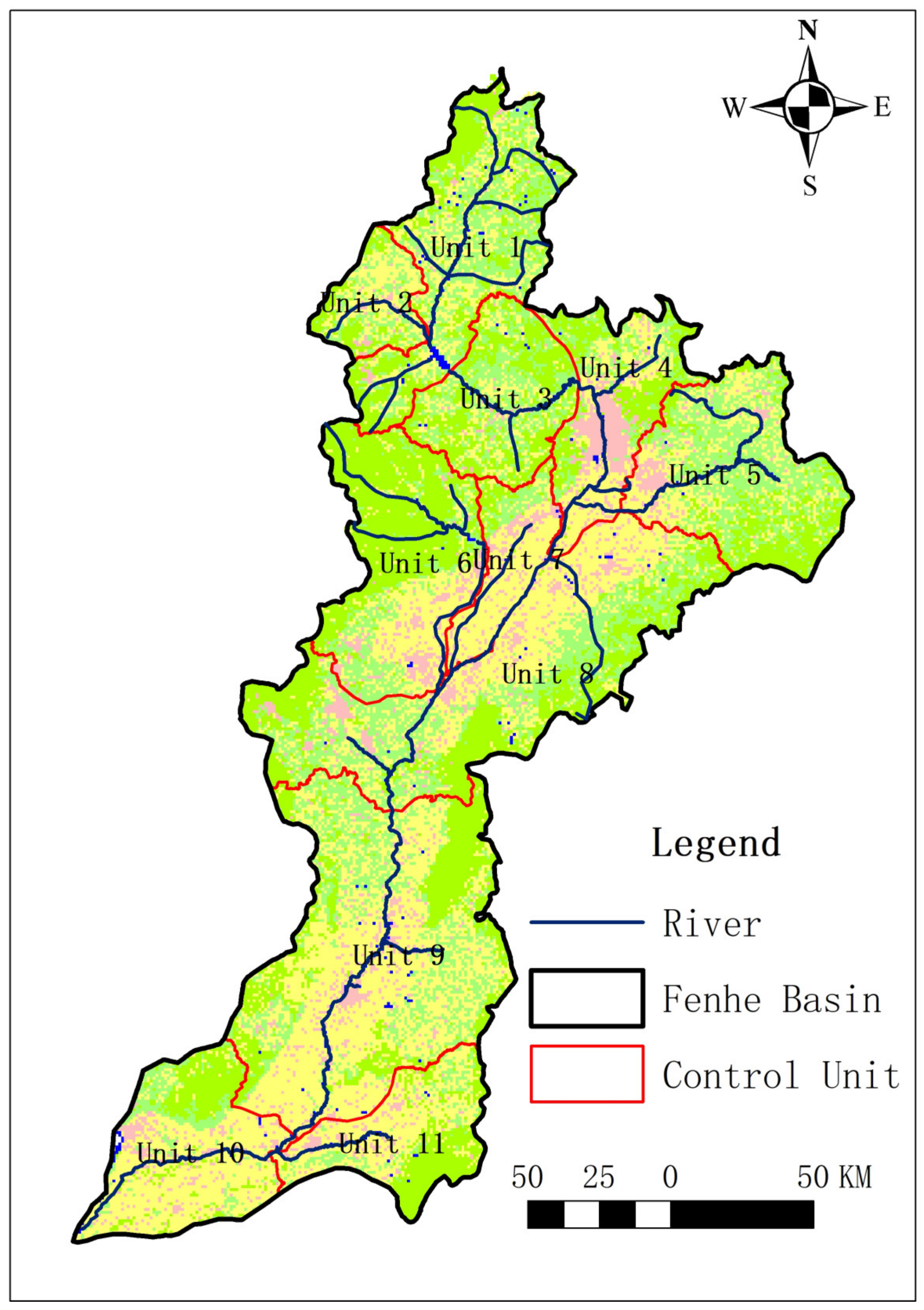
Fenhe River Basin is the second tributary of the Yellow River, located in the ecologically fragile area of the Loess Plateau (
Figure 1). It originates from Ningwu County in the north of Shanxi Province and finally flows into the Yellow River at Hejin County. It has a total length of 716 km and a drainage area of 39,741 km
2 [
20]. Over the past few decades, the water pollution problem in the basin was more prominent due to the neglect of the relationship between economic construction and environmentally coordinated development. Recently, the proportion of level V (GB 3838-2002) [
21] sections in the basin reached 62%, which seriously affected the health of the ecosystem and the economic development of this basin [
22,
23]. How to accurately control pollution and make the Fenhe River Basin reach the surface water standard is still a relatively prominent problem.
2.2. SWAT Model
The basic framework of SWAT model is to subdivide the study area into several hydrological response units (HRUs) [
8]. The data required for the construction and operation of SWAT model mainly include: digital elevation model (DEM) data, land use data, soil data, meteorological data, hydrological data, pollution source data, and agricultural management data (
Table 1).
The hydrological balance equation of SWAT model is as follows:
where
is the initial water content of the soil on day
i (mm),
t is the number of days (d),
is the precipitation on day
i (mm),
is the surface runoff (SR) on day
i (mm),
is the evapotranspiration on day
i (mm),
is the quantity of water entering the vadose zone from the soil profile on day
i (mm),
is the water quantity of regression flow on day
i (mm),
means the final soil water content (mm).
According to the distribution of nationally controlled sections, the Fenhe River Basin is divided into 11 national control units from north to south in this study (
Figure 1). In order to effectively control NPS pollution, the SWAT model is established based on the 11 control units of Fenhe River Basin in this study. Among them, unit 1 and 3 are in the upstream of Fenhe River Basin, with Fenhe Reservoir as the boundary; unit 4 is in the midstream of Fenhe River Basin, which cover the Taiyuan city; unit 8, 9 and 10 are in the downstream of Fenhe River Basin, with Linfen City as the boundary. Other units are in tributaries, unit 2 is in Lanhe River, unit 5 is in Xiaohe River, unit 6 is in Wenyuhe River, unit 7 is in Ciyaohe River, and unit 11 is in Huihe River.
2.3. Calibration and Validation of the SWAT Model
SWAT model needs to be calibrated and validated according to local actual conditions [
24]. SWAT-CUP (SWAT calibration and uncertainty programs) software can be used to calibrate and validate SWAT models. Nash efficiency coefficient (
ENS) and certainty coefficient (
R2) are used as the judgment basis for the calibration and validation of the model [
25]:
where
Qs is the model simulation value;
Qm is the measured value;
is the mean of the simulation value;
is the mean of the measured value and
n is the number of observations.
The calibration and validation are processed based on the monthly monitoring data of water flow, total phosphorus (TP) and ammonia nitrogen (NH
3-N) from 2010 to 2019 of Hejin hydrological station, of which 2010–2016 is the calibration period and 2017–2019 is the validation period. The range of
ENS is (−∞, 1], and the closer it is to 1, the higher the simulation accuracy. When
ENS ≥ 0.50, the simulation effect is satisfactory. The certainty coefficient (
R2) is an index used to describe the correlation between the simulated data and the measured data. The range is [0, 1], and the closer the value is to 1, the higher the fitting degree of the simulated and measured data. When
R2 ≥ 0.50, it indicates that the simulation effect is satisfactory [
25].
2.4. Calculation of Water Environment Capacity
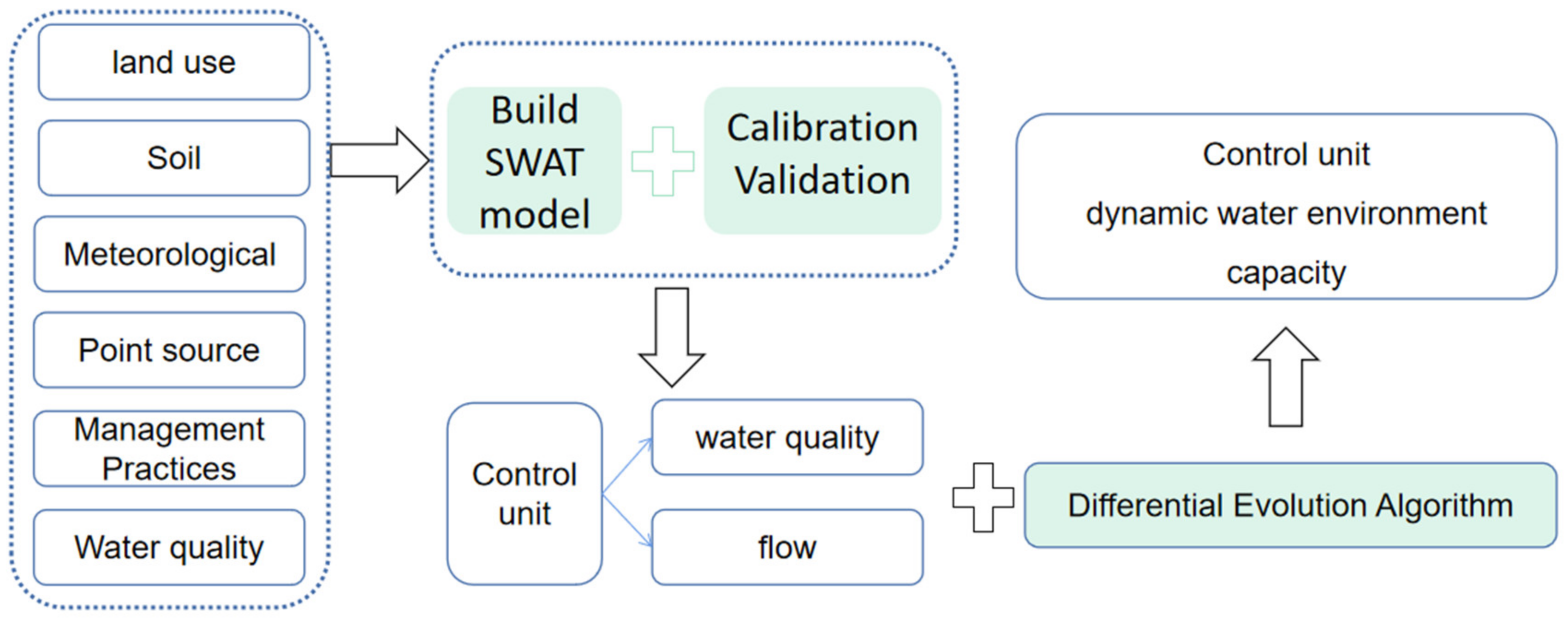
In this study, SWAT model and differential evolution algorithm (DE) were coupled to quantify the spatial and temporal variations of water environmental capacity (
Figure 2). DE algorithms have been widely used in many study fields, DE has been proved to be more robust and efficient in continuous encoding optimization [
12,
26]. The main calculation processes of the DE algorithm include the initialization of the parameter vectors, mutation with differential operators, and crossover and selection [
27]. In the calculation process, the daily outputs of SWAT model, including daily flow, water temperature, algae concentration, and other factors related to the calculation of water environment capacity, were directly used as the inputs of DE algorithm to calculate the water environment capacity [
12]. The formula of DE algorithm is as follows:
where
is the generated variation vector;
and
are random individuals selected from existing populations; and
is the mutation operator.
The ideal water environment capacity and the residual water environment capacity of each river channel in Fenhe River Basin from 2010 to 2019 were calculated in this study according to the water quality objectives of Fenhe River Basin in 2020. The ideal water environment capacity is the water environment capacity calculated according to the water quality target value without considering pollution. The residual water environment capacity is the water environment capacity after removing the pollution load from upstream and the pollution load from this unit.
3. Results and Discussion
3.1. Swat Model Calibration and Validation
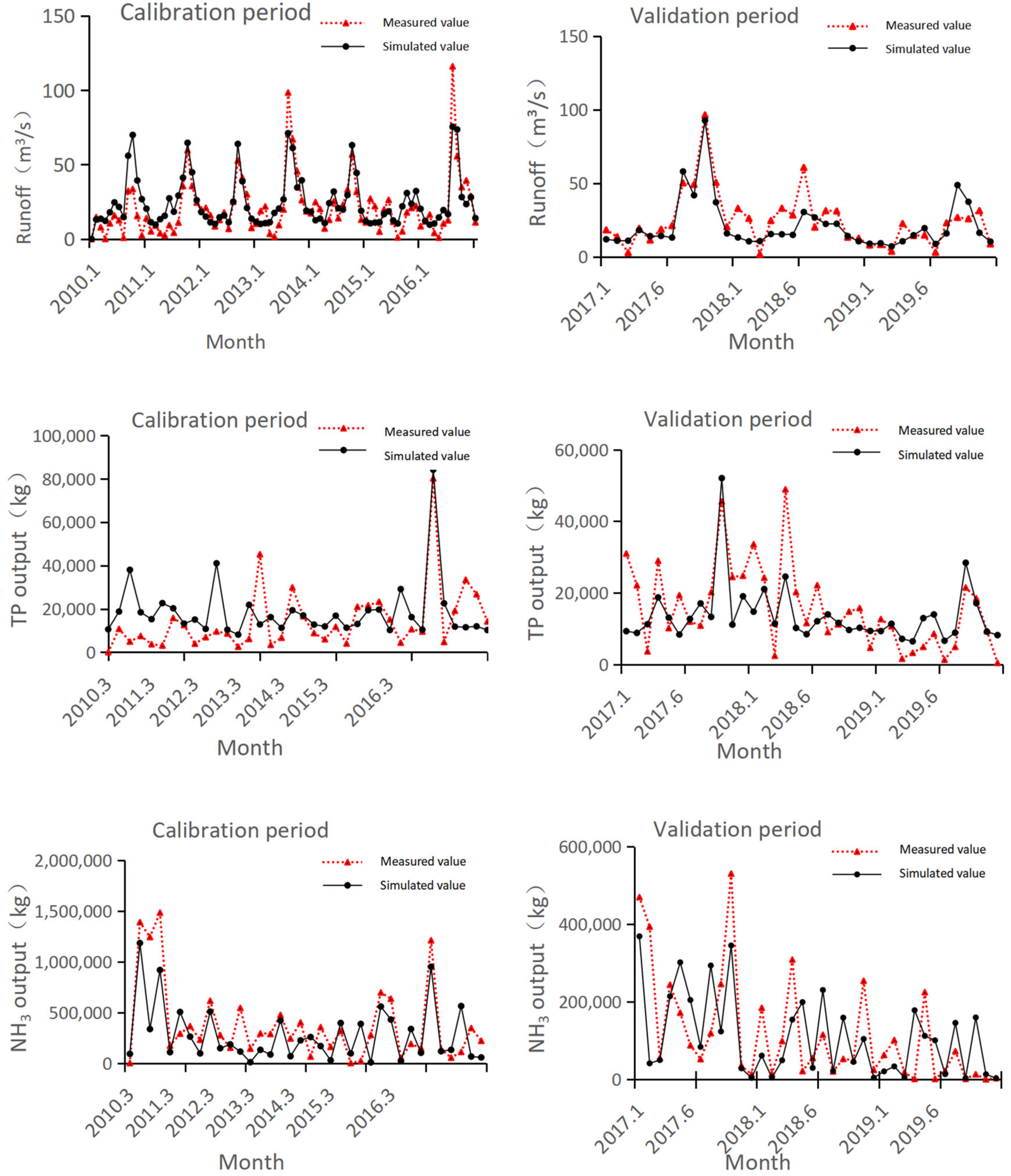
The SWAT model was constructed based on 11 control units of the Fenhe River Basin, and the water quantity and quality of the established SWAT model were calibrated and validated (
Figure 3). The results showed that the
ENS and
R2 of flow in the calibration period were 0.64 and 0.68, respectively; and the
ENS and
R2 of flow in the validation period were 0.70 and 0.79, respectively. The
ENS and
R2 of TP in the calibration period were 0.53 and 0.57, respectively; and the
ENS and
R2 of TP in the validation period were 0.51 and 0.55, respectively. The
ENS and
R2 of NH
3-N in the calibration period were 0.54 and 0.59, respectively; and the
ENS and
R2 of NH
3-N in the validation period were 0.53 and 0.51, respectively. Therefore, the SWAT model based on the control unit met the requirements of calibration and validation and the results of the model could be further analyzed.
3.2. Distribution of Water Quantity and Water Quality
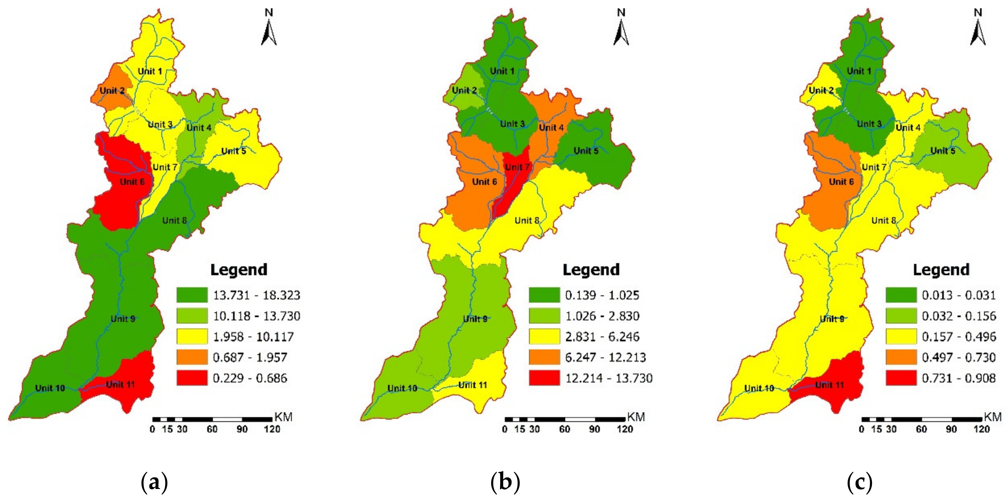
Based on the simulation results of the SWAT model, the flow of the Fenhe River Basin in 2019 is analyzed (
Figure 4). The results showed that the flow of the main stream in the upstream of Fenhe River Basin was relatively low, at 7.62–8.40 m
3/s. With the inflow of the tributaries, the flow in the midstream and downstream gradually increases, reaching 17.58 m
3/s in the midstream, 18.32 m
3/s in the Linfen section in the downstream, and 16.08 m
3/s before flowing into the Yellow River. Compared with the main stream, the flow in tributaries was generally low. The flow of Wenyu River in unit 6 and Huihe River in unit 11 were only 0.23 m
3/s and 0.62 m
3/s.
In terms of water quality, the average annual concentrations of NH3-N and TP in unit 1 and unit 3 in the main stream of the upstream region were relatively low, with concentration of NH3-N 0.14–0.18 mg/L and concentration of TP 0.01–0.02 mg/L. According to the requirements of the environmental quality standard for surface water (GB 3838-2002), the concentrations of both NH3-N and TP met level II. Unit 1 and unit 3 cover the section from Leiming temple, the source of Fenhe River Basin, to the outlet of Fenhe Reservoir. It is an important area of water source in Shanxi Province. The water quality is good, and the impact of human activities is low. In unit 4 in the midstream of the main stream, the concentration of NH3-N and TP reached the highest, which were 6.75 mg/L and 0.41 mg/L, respectively, exceeding class V inferior to surface water. The concentrations of NH3-N and TP in units 8, 9, and 10 in the downstream all showed a downward trend. The concentration of NH3-N decreased from 3.64 mg/L to 1.72 mg/L, and the concentration of TP decreased from 0.38 mg/L to 0.19 mg/L, but the concentrations of both NH3-N and TP exceeded level III.
The water quality of the tributaries was generally worse than that of the main stream. The concentrations of NH3-N in unit 2 Lanhe River, unit 11 Huihe River, unit 6 Wenyuhe River, and unit 7 Ciyaohe River were more prominent, with a range of 2.05–13.73 mg/L, all of them were inferior to class V water quality. Different from other tributaries, the water quality of Xiaohe River in unit 5 was the best. The concentrations of NH3-N and TP were 0.68 mg/L and 0.12 mg/L, respectively, meeting level III (GB 3838-2002).
3.3. Water Environment Capacity of Control Unit
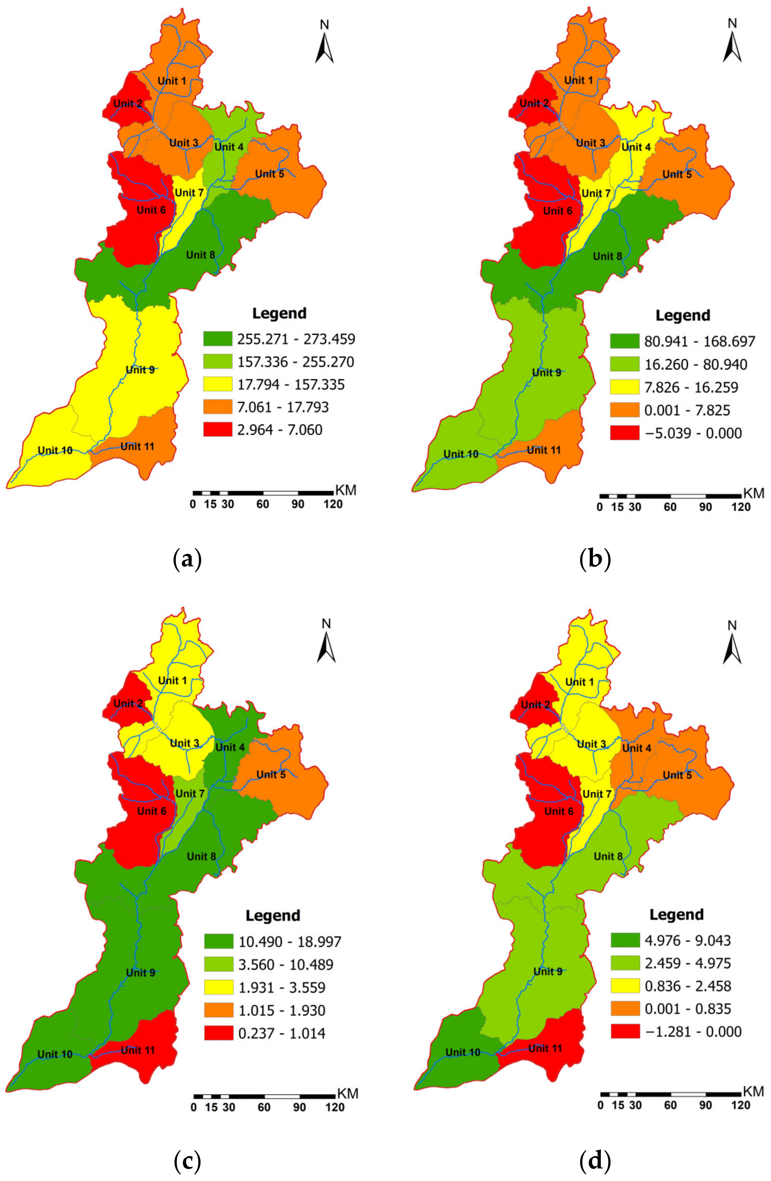
Combined with the water quality management objectives of the Fenhe River Basin, the ideal capacity and residual capacity of each control unit were obtained through the SWAT model and differential evolution algorithm (
Figure 5). Overall, the annual average showed that the residual capacities of NH
3-N and TP in the main stream of the Fenhe River Basin were positive, indicating that the actual loads of both NH
3-N and TP were less than the acceptable load of the Fenhe River Basin.
However, the water environment capacities of different river sections were quite different. The results showed that the ideal capacities of unit 1 and unit 3 in the upstream of the main stream were low due to the small flow, but the water quality in this section was good, resulting in very low consumption of ideal capacity, and the residual capacity could account for 60–87% of the ideal capacity. With the inflow of water from the Yellow River and the tributaries, the ideal capacity of unit 4 in the midstream of the Fenhe River Basin raised significantly, but the consumption rate of ideal capacity was extremely high, and the residual capacities of NH3-N and TP were only 10% and 5%. However, the residual capacity of units 8, 9, and 10 in the downstream rebounded, but the consumption rate of ideal capacity was relatively large. In particular, the residual capacity of TP in unit 8 was only 18%. The residual capacities of NH3-N and TP in unit 2 and unit 6 in the tributary were negative, indicating that the load of NH3-N and TP was more than that of the self-purification function of the river basin. Additionally, the residual capacity of TP in unit 11 was also negative.
3.4. Analysis of Dynamic Water Environment Capacity
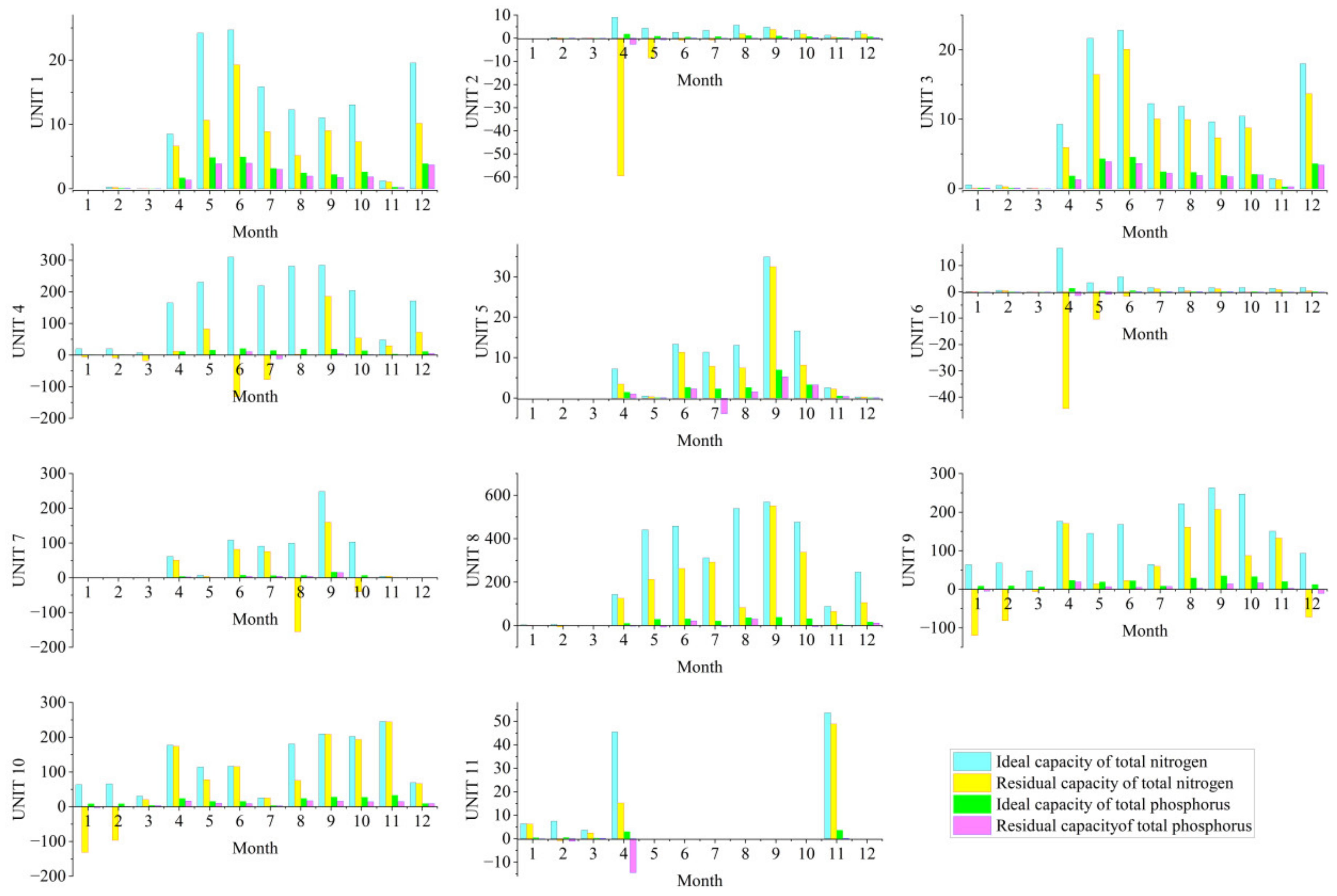
In order to explore the spatial–temporal distribution characteristics of water environmental capacity in Fenhe River Basin, the dynamic water environmental capacity was further analyzed (
Figure 6). In general, the interannual ideal water environment capacity and residual water environment capacity of all control units in the Fenhe River Basin were positive. The results showed that the water quality of the Fenhe River Basin had been greatly improved since the 13th Five-Year Plan. These might be closely related to the pollution prevention measures in Shanxi Province. For example, Shanxi Province had issued local standards for sewage discharge which were stricter than the national standards [
28].
However, the differences in water environment capacity each month were relatively obvious. From June to September in the wet season, the ideal water environment capacity of most control units increased significantly with the increase in rainfall. However, the residual capacity did not increase in proportion and even showed negative values in some units. Especially in unit 4 in the midstream of the main stream, the residual capacity of NH
3-N reached the highest negative value in June and July, which were—77.2 tons/month and—131.8 tons/month. The negative value of TP also reached its highest in July, which was—12.1 tons/month. The negative value of residual water environmental capacity indicated that NPS pollution was the main factor affecting the water environmental capacity of the midstream of Fenhe River Basin in the wet season. In the wet season, the ideal capacity reaches the highest with the maximum water volume, but the NPS pollution is also greatly increased with the surge of rainfall, resulting in the largest loss of residual load [
29,
30]. The sown area of grain in the Taiyuan Section of the Fenhe River Basin is up to 70,986 hectares, which is one of the main grain-producing areas in the Fenhe River Basin [
20]. The large area of farmland can lead to high NPS pollution in this unit. At the same time, domestic water consumption surges in summer, the load of urban sewage treatment plants increases, and the consumption of residual capacity is extremely high [
31,
32]. The random discharge of domestic sewage in surrounding rural areas also aggravates the contribution of NPS pollution of this unit [
33,
34].
Among the tributaries, the residual capacity of Unit 7 Ciyaohe River dropped sharply in August and October, reaching a negative peak of −155.3 tons/month. Like the main stream, the NPS is still a key factor for pollution during the rainy season. The Ciyaohe River flows through agriculture-intensive areas, and the extensive aquaculture industry and the scattered discharge of rural domestic sewage are sharply flowing into the Ciyaohe River Basin with the strengthening of runoff [
35]. In 2019, the Department of Ecology and Environment of Shanxi Province and the Shanxi Provincial Public Security Department conducted centralized inspections and found that the problem of scattered pollution discharge was extremely serious [
36].
Although the residual capacity of units 8, 9, and 10 in downstream of the main stream did not show negative values during the wet season, the low value of residual capacity showed the characteristics of a surge of pollutants with the increase in rainfall, and the consumption of ideal capacity reached 21–40% of the year. It shows that NPS pollution is still the main source in the lower reaches of the Fenhe River Basin in the wet season. These units of the Fenhe River Basin are located in Linfen and Yuncheng areas, which are the main grain and cotton production areas in Shanxi Province, so the contribution of NPS pollution cannot be underestimated [
37].
In addition to the negative value of residual capacity in the wet season, there were high negative values of residual capacity in the downstream units 8, 9, and 10 in the dry season in January and February. In general, the NPS pollution is low in the dry season, while the point source pollution accounts for a large proportion [
9]. Units 8, 9, and 10 lie in the Linfen and Yuncheng sections, and a large number of industrial enterprises are distributed along the banks, which may have a great impact on the water quality of the Fenhe River Basin [
38]. In addition, the Lanhe River in unit 2, the Wenyuhe River in unit 6, and the Huihe River in unit 11 also showed negative values of residual capacity in April and May. It may be because the water flow in April and May is low and the ideal capacity is low, while the NPS pollution runoff is gradually strengthened [
12]. Due to the joint action of point source and non-point source, the total load of pollutants exceeds the ideal water environment capacity [
39].
Scientific quantification of water environmental capacity is the basis of watershed pollutant management, and the accurate calculation of dynamic water environmental capacity is the key to achieving accurate management of river basins. At present, researchers have begun to explore management measures based on dynamic water environmental capacity [
40,
41]. This study calculated the dynamic water environment capacity based on the control unit. On the one hand, the pollution reduction policy can be better implemented with the division of administrative regions. On the other hand, the management measures can be determined more accurately and efficiently at different times for river basins based on the dynamic water environment capacity.
4. Conclusions
The flow of the main stream in the upstream was relatively low. With the inflow of the tributaries, the flow in the midstream and downstream gradually increased, and the flow of the Linfen section in the lower reaches reached the highest. The final flow that merged into the Yellow River was 16.08 m3/s. The flow in tributary was generally lower than the main stream, the Wenyuhe River and the Huihe River had been cut off for many months in the year. In terms of water quality, the upstream of the Fenhe River Basin, including the source area of Fenhe River Basin and the outlet of Fenhe Reservoir, the water quality was as well as level III. The load of pollutants in the midstream reached the highest, far exceeding level III. The load of pollutants in the downstream decreased, but it also exceeded level III. The water quality of the tributaries was generally serious, and only the water quality in Xiaohe River was good, which met level III.
The residual capacities of NH3-N and TP in the main stream were all positive, which indicated that the measures of vigorously promoting pollution in the Fenhe River Basin in Shanxi Province in recent years are effective. However, based on the analysis of dynamic water environment capacity, it showed that there was still a big gap in the stable and accurate pollution control of the Fenhe River Basin. Especially in the wet season, the problem of NPS pollution in the midstream and downstream is more prominent, resulting in a high consumption rate of ideal capacity. At the same time, the water environment capacities of different river sections were quite different. The consumption of ideal capacity in the Taiyuan Section in the midstream was the highest, mainly occurring in the wet season. The negative values of the residual capacity of NH3-N and TP reached the highest, −131.3 tons/month and −12.1 tons/month. In addition, the consumption of the ideal capacity in the downstream reached 21–40% of the whole year in the wet season. With the rapid increase in rainfall, the surge of NPS pollution, and the peak of domestic water consumption in summer, the water environment capacity is insufficient. In addition to the impact of NPS pollution in the wet season, the impact of point source pollution on residual capacity is also relatively large. Affected by point source pollution, the negative values of residual capacity in downstream units 8, 9, and 10 were high in the dry season in January and February.
The results of water environmental capacity showed that there was an obvious difference in different months of the year. Especially in the wet season, the NPS pollution problem in the midstream and downstream was more prominent, resulting in a high-capacity consumption rate. In addition, the water environmental capacity of different units also varied greatly. The capacity consumption of the Taiyuan Section in the midstream was the highest. The dynamic water environment capacity based on the control unit effectively combined with the division of administrative regions, and the management measures were more accurate and efficient for the river basin.
Author Contributions
Conceptualization, R.L.; Software, Y.L.; Data curation, X.P.; Writing—original draft, L.W.; Writing—review & editing, D.D. All authors have read and agreed to the published version of the manuscript.
Funding
This study was funded by Shanxi Province Water Conservancy Science Technology research and Promotion project (2023GM33), Major Decision Consultation Project of Shanxi Provincial Government (ZB20213606), and Scientific Research Projects for Doctoral Researchers in Shanxi Province (SXBYKY2022092).
Data Availability Statement
All the data used to support the findings of this study are available from the corresponding author upon request.
Acknowledgments
The authors thank the editors and anonymous reviewers for their valuable comments and suggestions.
Conflicts of Interest
The authors declare no conflict of interest.
References
- Zhang, W.; Wang, X.J. Modeling for point-non-point source effluent trading: Perspective of non-point sources regulation in China. Sci. Total Environ. 2002, 292, 167–176. [Google Scholar] [CrossRef] [PubMed]
- Bai, J.; Li, Y.; Sun, W. Research on emission characteristics of agricultural non-point source pollution based on Kuznets fitting curve. Arab. J. Geosci. 2021, 14, 1324. [Google Scholar] [CrossRef]
- Jha, R.; Ojha, C.S.P.; Bhatia, K.K.S. Non-point source pollution estimation using a modified approach. Hydrol. Process. 2007, 21, 1098–1105. [Google Scholar] [CrossRef]
- Pearson, B.J.; Chen, J.J.; Beeson, R.C. Evaluation of Storm Water Surface Runoff and Road Debris as Sources of Water Pollution. Water Air Soil Pollut. 2018, 229, 194. [Google Scholar] [CrossRef]
- Ongley, E.D.; Zhang, X.L.; Yu, T. Current status of agricultural and rural non-point source Pollution assessment in China. Environ. Pollut. 2010, 158, 1159–1168. [Google Scholar] [CrossRef]
- Yuan, X.D.; Jun, Z. Water Resource Risk Assessment Based on Non-Point Source Pollution. Water 2021, 13, 1907. [Google Scholar] [CrossRef]
- Zhang, X.Q.; Chen, P.; Dai, S.N.; Han, Y.H. Analysis of non-point source nitrogen pollution in watersheds based on SWAT model. Ecol. Indic. 2022, 138, 108881. [Google Scholar] [CrossRef]
- Kassem, A.A.; Raheem, A.M.; Khidir, K.M.; Alkattan, M. Predicting of daily Khazir basin flow using SWAT and hybrid SWAT-ANN models. Ain Shams Eng. J. 2020, 11, 435–443. [Google Scholar] [CrossRef]
- Liu, R.M.; Xu, F.; Zhang, P.P.; Yu, W.W.; Men, C. Identifying non-point source critical source areas based on multi-factors at a basin scale with SWAT. J. Hydrol. 2016, 533, 379–388. [Google Scholar] [CrossRef]
- Zhang, D.J.; Lin, Q.Y.; Yao, H.X.; He, Y.R.; Deng, J.; Zhang, X.X. Accelerating SWAT Simulations Using An In-Memory NoSQL Database. J. Environ. Inform. 2021, 37, 142–152. [Google Scholar] [CrossRef]
- Tripathi, M.P.; Panda, R.K.; Raghuwanshi, N.S. Development of effective management plan for critical subwatersheds using SWAT model. Hydrol. Process. 2005, 19, 809–826. [Google Scholar] [CrossRef]
- Wang, Q.R.; Liu, R.M.; Men, C.; Guo, L.J.; Miao, Y.X. Temporal-spatial analysis of water environmental capacity based on the couple of SWAT model and differential evolution algorithm. J. Hydrol. 2019, 569, 155–166. [Google Scholar] [CrossRef]
- Huang, J.; Pang, Y.; Zhang, X.Q.; Tong, Y.F. Water Environmental Capacity Calculation and Allocation of the Taihu Lake Basin in Jiangsu Province Based on Control Unit. Int. J. Environ. Res. Public Health 2019, 16, 3774. [Google Scholar] [CrossRef] [PubMed] [Green Version]
- Liu, R. Research on control method of pollutant total amount of water quality based on fuzzy mathematics. Earth Sci. Res. J. 2020, 24, 191–199. [Google Scholar] [CrossRef]
- Pang, J. Adaptive Assessment of Urban Water Environment Carrying Capacity Based on Water Quality Target Constrains. Fresenius Environ. Bull. 2020, 29, 7688–7696. [Google Scholar]
- Wang, Q.R.; Liu, R.M.; Men, C.; Guo, L.J.; Miao, Y.X. Effects of dynamic land use inputs on improvement of SWAT model performance and uncertainty analysis of outputs. J. Hydrol. 2018, 563, 874–886. [Google Scholar] [CrossRef]
- Jin, H.Y.; Chen, W.Q.; Zhao, Z.H.; Wang, J.J.; Ma, W.C. New Framework for Dynamic Water Environmental Capacity Estimation Integrating the Hydro-Environmental Model and Load-Duration Curve Method—A Case Study in Data-Scarce Luanhe River Basin. Int. J. Environ. Res. Public Health 2022, 19, 8389. [Google Scholar] [CrossRef]
- Wang, T.X.; Xu, S.G. Dynamic successive assessment method of water environment carrying capacity and its application. Ecol. Indic. 2015, 52, 134–146. [Google Scholar] [CrossRef]
- Liu, R.M.; Miao, Y.X.; Wang, Q.R.; Jiao, L.J.; Wang, Y.F.; Li, L.; Cao, L.P. Effectivity and Efficiency of Best Management Practices Based on a Survey and SWAPP Model of the Xiangxi River Basin. Water 2021, 13, 985. [Google Scholar] [CrossRef]
- Wang, L.F.; Li, H.; Dang, J.H.; Zhao, Y.; Zhu, Y.E.; Qiao, P.M. Effects of Urbanization on Water Quality and the Macrobenthos Community Structure in the Fenhe River, Shanxi Province, China. J. Chem. 2020, 2020, 8653486. [Google Scholar] [CrossRef]
- GB3838-2002; Standards of Surface Water Environmental Quality of the People’s Republic of China. China Environmental Science Press: Beijing, China, 2002.
- Ma, H.T.; Zhen, Z.L.; Mi, M.X.; Wang, Q. Characteristics of nutrients pollution and ecological risk assessment of heavy metal in sediments of Fenhe River, Taiyuan Section, China. Water Supply 2022, 22, 2596–2611. [Google Scholar] [CrossRef]
- Wang, L.F.; Wang, Y.F.; Li, H.; Zhu, Y.E.; Liu, R.M. Occurrence, source apportionment and source-specific risk assessment of antibiotics in a typical tributary of the Yellow River basin. J. Environ. Manag. 2022, 305, 114382. [Google Scholar] [CrossRef] [PubMed]
- Lazzari Franco, A.C.; de Oliveira, D.Y.; Bonuma, N.B. Comparison of single-site, multi-site and multi-variable SWAT calibration strategies. Hydrol. Sci. J.-J. Des Sci. Hydrol. 2020, 65, 2376–2389. [Google Scholar] [CrossRef]
- Singh, V.; Bankar, N.; Salunkhe, S.S.; Bera, A.K.; Sharma, J.R. Hydrological stream flow modelling on Tungabhadra catchment: Parameterization and uncertainty analysis using SWAT CUP. Curr. Sci. 2013, 104, 1187–1199. [Google Scholar]
- Hou, Y.; Zhao, L.; Lu, H. Fuzzy neural network optimization and network traffic forecasting based on improved differential evolution. Future Gener. Comput. Syst. 2018, 81, 425–432. [Google Scholar] [CrossRef]
- Storn, R.; Price, K. Differential evolution—A simple and efficient heuristic for global optimization over continuous spaces. J. Glob. Optim. 1997, 11, 341–359. [Google Scholar] [CrossRef]
- Li, L.; Wang, L.F.; Liu, R.M.; Cao, L.P.; Wang, Y.; Liu, Y. Evaluating the impacts of inter-basin water transfer projects on ecosystem services in the Fenhe River Basin using the SWAT model. Environ. Monit. Assess. 2023, 195, 455. [Google Scholar] [CrossRef]
- Woo, J.S.; Shin, H.G. The Runoff Characteristics of Non-point Pollution Sources in Industrial Complex(I): Focusing on the analysis of runoff water according to the initial rainfall of the C Industrial Complex. J. Korea Org. Resour. Recycl. Assoc. 2022, 30, 23–32. [Google Scholar]
- Tang, Z.; Cai, Q.; Xu, F.; Li, S.; Wang, Z. Mechanism of contour hedgerow’s control for non-point pollution in the semiarid region in northwest Hebei Province. Huan Jing Ke Xue 2001, 22, 86–90. [Google Scholar]
- Minareci, O.; Ozturk, M.; Egemen, O.; Minareci, E. Detergent and phosphate pollution in Gediz River, Turkey. Afr. J. Biotechnol. 2009, 8, 3568–3575. [Google Scholar]
- Hayward, E.E.; Gillis, P.L.; Bennett, C.J.; Prosser, R.S.; Salerno, J.; Liang, T.; Robertson, S.; Metcalfe, C.D. Freshwater mussels in an impacted watershed: Influences of pollution from point and non-point sources. Chemosphere 2022, 307, 135966. [Google Scholar] [CrossRef] [PubMed]
- Hou, L.; Zhou, Z.; Wang, R.; Li, J.; Dong, F.; Liu, J. Research on the Non-Point Source Pollution Characteristics of Important Drinking Water Sources. Water 2022, 14, 211. [Google Scholar] [CrossRef]
- Kumwimba, M.N.; Meng, F.; Iseyemi, O.; Moore, M.T.; Bo, Z.; Tao, W.; Liang, T.J.; Ilunga, L. Removal of non-point source pollutants from domestic sewage and agricultural runoff by vegetated drainage ditches (VDDs): Design, mechanism, management strategies, and future directions. Sci. Total Environ. 2018, 639, 742–759. [Google Scholar] [CrossRef] [PubMed]
- Hui, X.M.; Jin, Y.; Chao, L.; Fan, X.J.; Yuan, Z. Analysis of hydrochemical characteristics and genesis of water-deficient rivers in China: A case study of the Ciyao River Basin in Shanxi Province. Qual. Assur. Saf. Crops Foods 2023, 15, 32–43. [Google Scholar]
- Meng, C.; Zhou, S.Y.; Li, W. An Optimization Model for Water Management under the Dual Constraints of Water Pollution and Water Scarcity in the Fenhe River Basin, North China. Sustainability 2021, 13, 10835. [Google Scholar] [CrossRef]
- Liu, M.X.; Han, Z.Q.; Yang, Y.Y. Accumulation, temporal variation, source apportionment and risk assessment of heavy metals in agricultural soils from the middle reaches of Fenhe River basin, North China. Rsc Adv. 2019, 9, 21893–21902. [Google Scholar] [CrossRef] [Green Version]
- Zhao, Y.; Dang, J.H.; Wang, L.F. Sources of Nitrogen Pollution in Upstream of Fenhe River Reservoir Based on the Nitrogen and Oxygen Stable Isotope. J. Chem. 2020, 2020, 6574210. [Google Scholar] [CrossRef]
- Liu, R.M.; Wang, Q.R.; Xu, F.; Men, C.; Guo, L.J. Impacts of manure application on SWAT model outputs in the Xiangxi River watershed. J. Hydrol. 2017, 555, 479–488. [Google Scholar] [CrossRef]
- Wu, L.; Chen, Z.; Ding, X.; Liu, H.Y.; Wang, D.Q. Research on water environmental capacity accounting of the Yongzhou Section of Xiangjiang River Basin based on the SWAT-EFDC coupling model. J. Water Clim. Change 2022, 13, 1106–1122. [Google Scholar] [CrossRef]
- Ma, B.; Dong, F.; Peng, W.Q.; Liu, X.B.; Ding, Y.; Huang, A.P.; Gao, X.W. Simulating the Water Environmental Capacity of a Seasonal River Using a Combined Watershed-Water Quality Model. Earth Space Sci. 2020, 7, e2019EA001008. [Google Scholar] [CrossRef]
| Disclaimer/Publisher’s Note: The statements, opinions and data contained in all publications are solely those of the individual author(s) and contributor(s) and not of MDPI and/or the editor(s). MDPI and/or the editor(s) disclaim responsibility for any injury to people or property resulting from any ideas, methods, instructions or products referred to in the content. |
© 2023 by the authors. Licensee MDPI, Basel, Switzerland. This article is an open access article distributed under the terms and conditions of the Creative Commons Attribution (CC BY) license (https://creativecommons.org/licenses/by/4.0/).
