
Hydraulic Modeling and Remote Sensing Monitoring of Floodhazard in Arid Environments—A Case Study of Laayoune City in Saquia El Hamra Watershed Southern Morocco
 ,
,  , and
, and
Abstract
1. Introduction
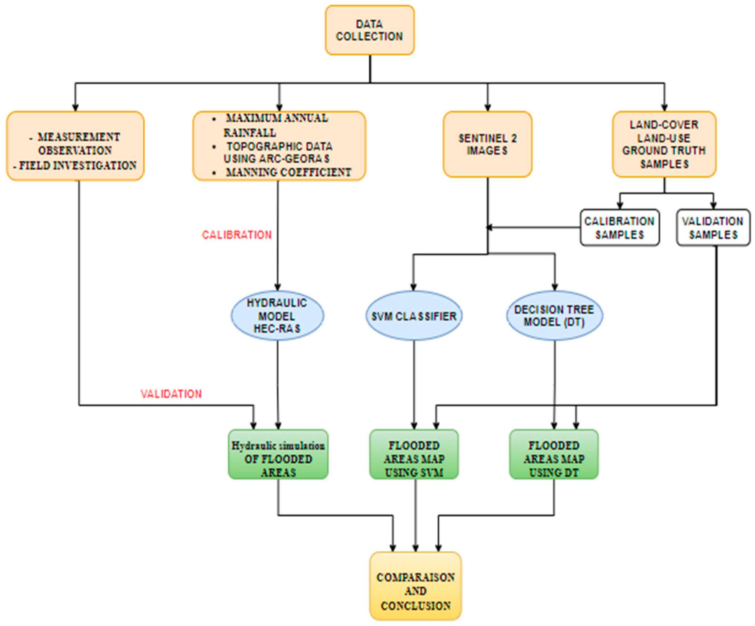
2. Materials and Methods
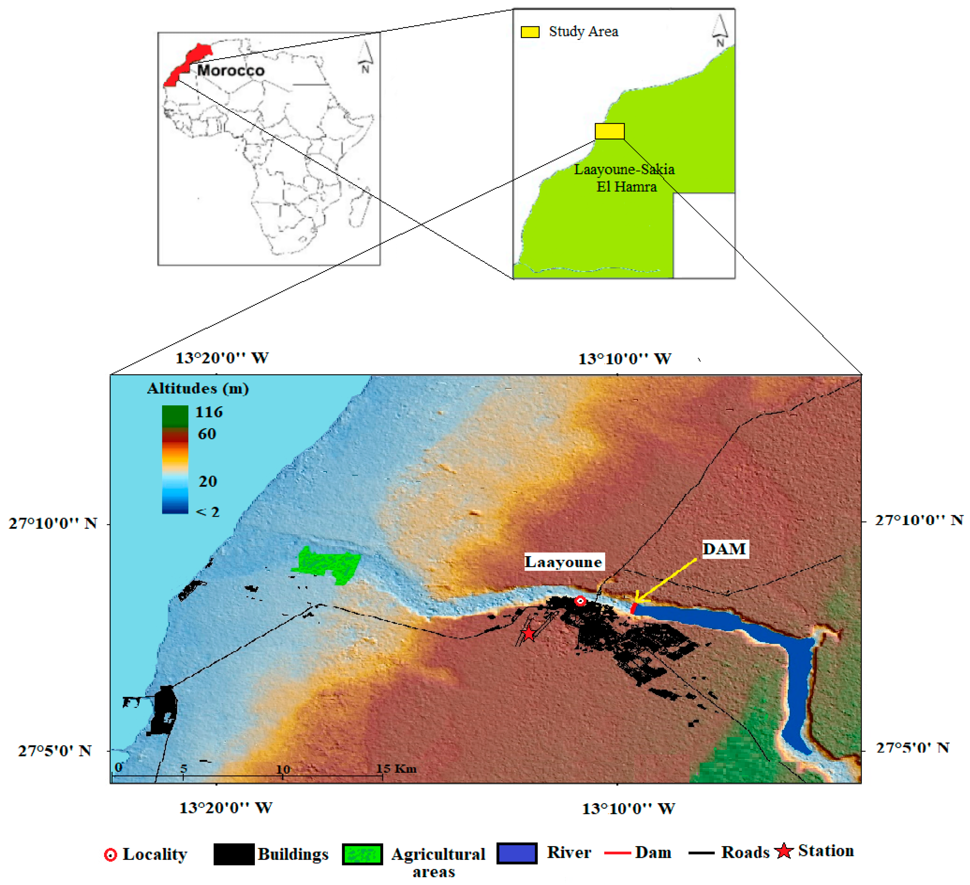
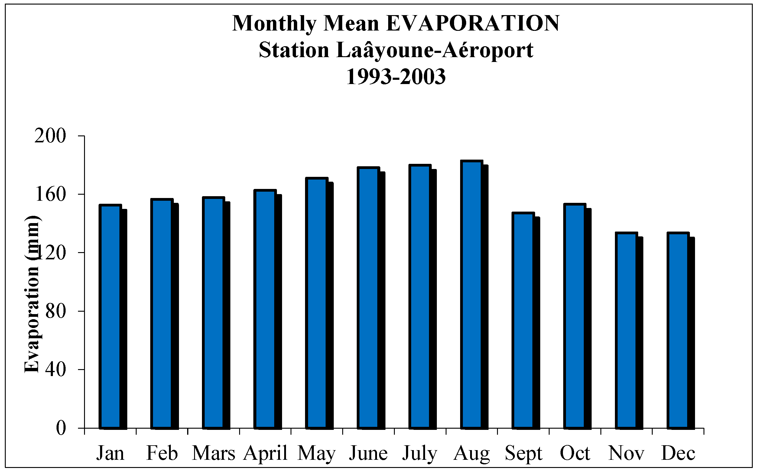
2.1. Study Area
2.2. Data Collection
2.2.1. Hydraulic Model
2.2.2. Remote Sensing Data
2.3. Modeling Approaches
2.3.1. Hydraulic Model
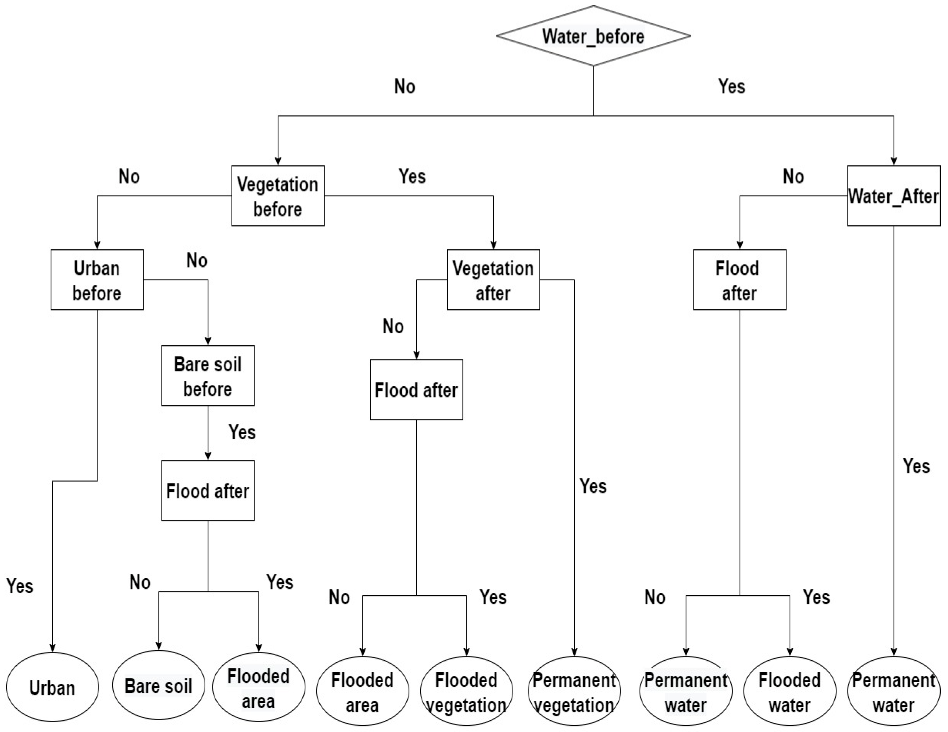
2.3.2. Satellite Images Classification
Support Vector Machines (SVM)
Decision Tree Model (DT)
2.4. Calibration and Validation
3. Results and Discussion
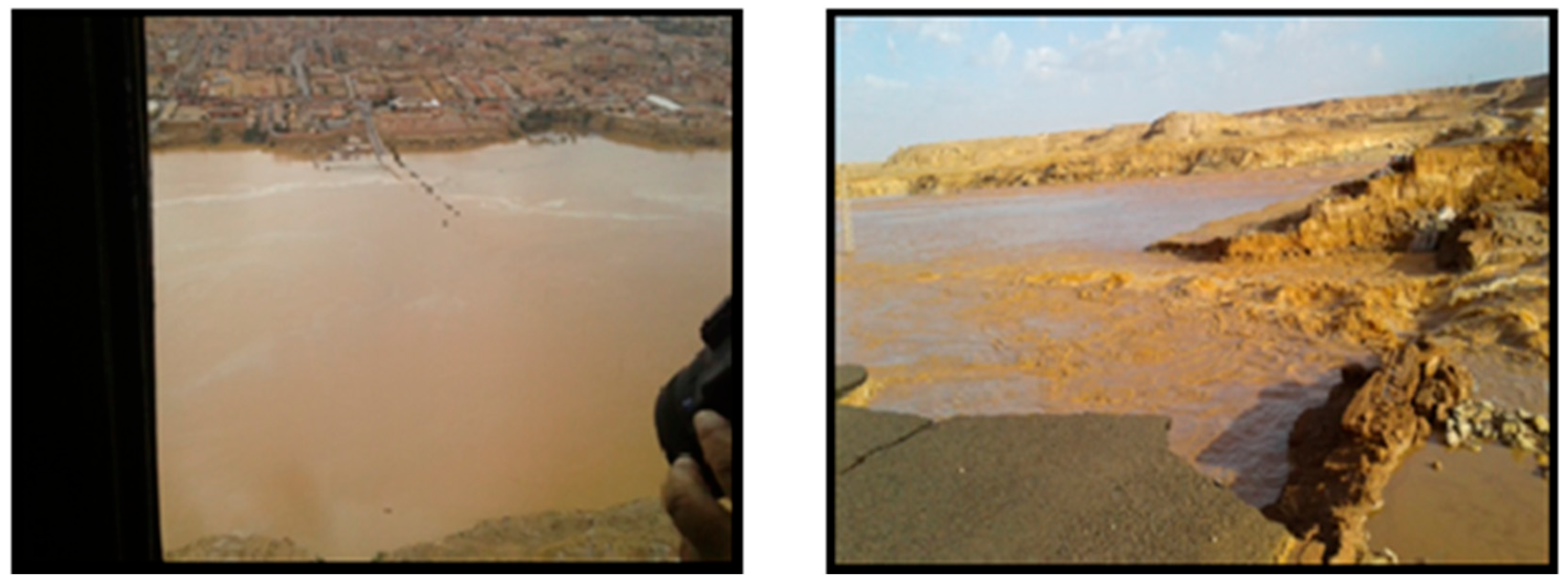
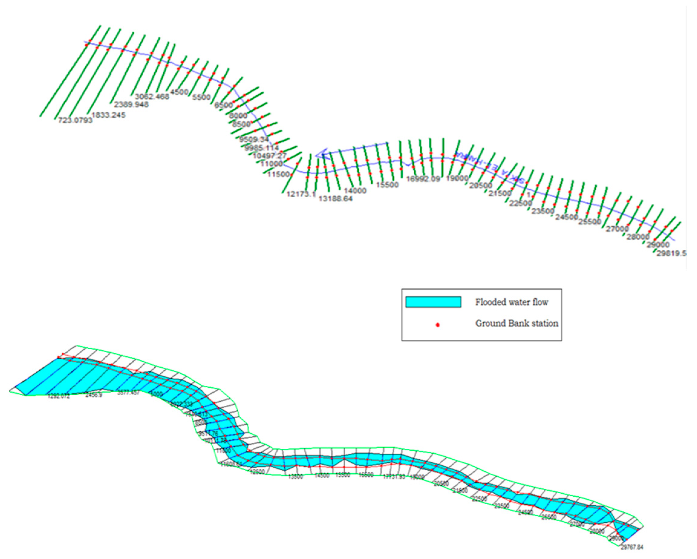
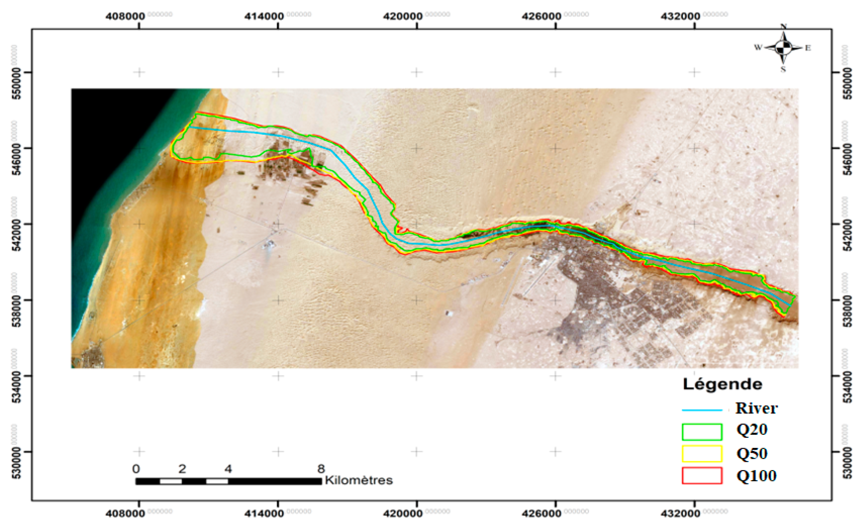
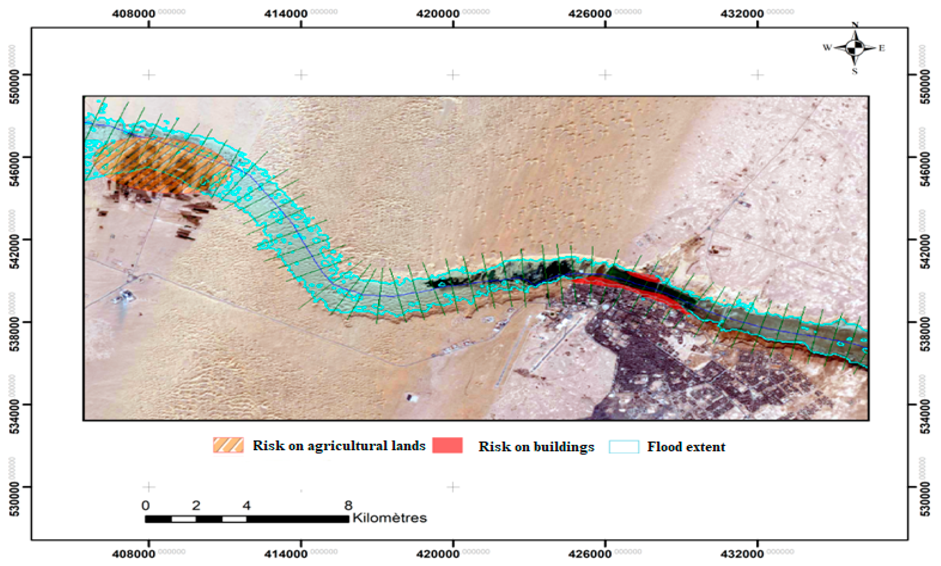
3.1. Hydraulic Modeling
- ▪
- At the city of Laayoune’s level:
- The destruction of current infrastructure (the national road, N1, linking Laayoune and Tarfaya and the dyke of the Sakia El Hamra dam);
- The destruction of the banks;
- A few homes sustained damage, as well as residents of neighboring communities on the left bank of the Oued (douar Lamkhaznia).
- ▪
- At Foum El Oued:
- The inundation of agricultural lands;
- The inundation of the cornice;
- A few houses sustained damage as well.
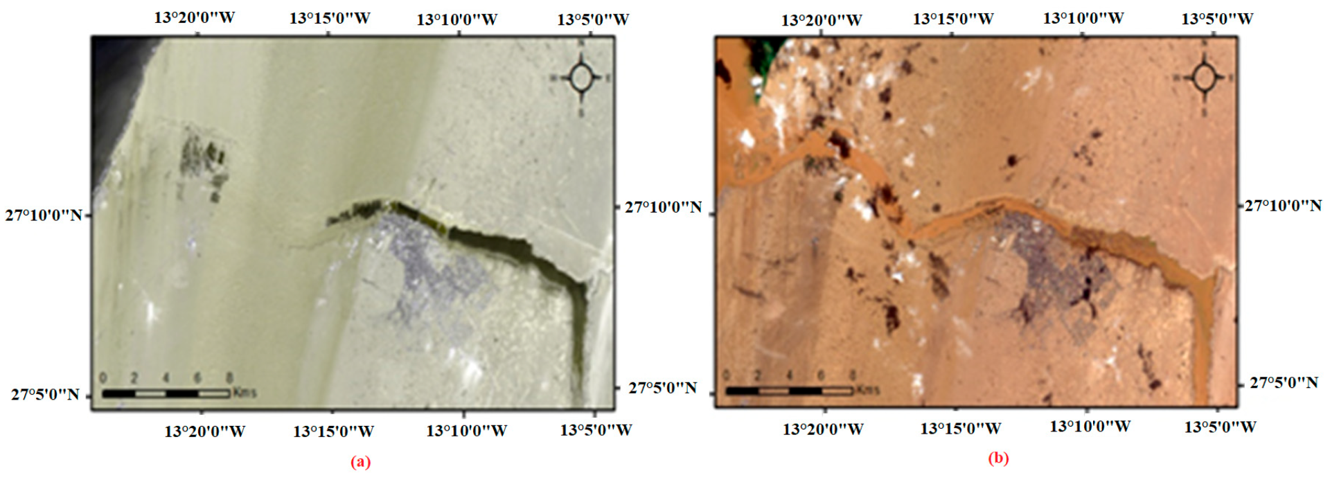
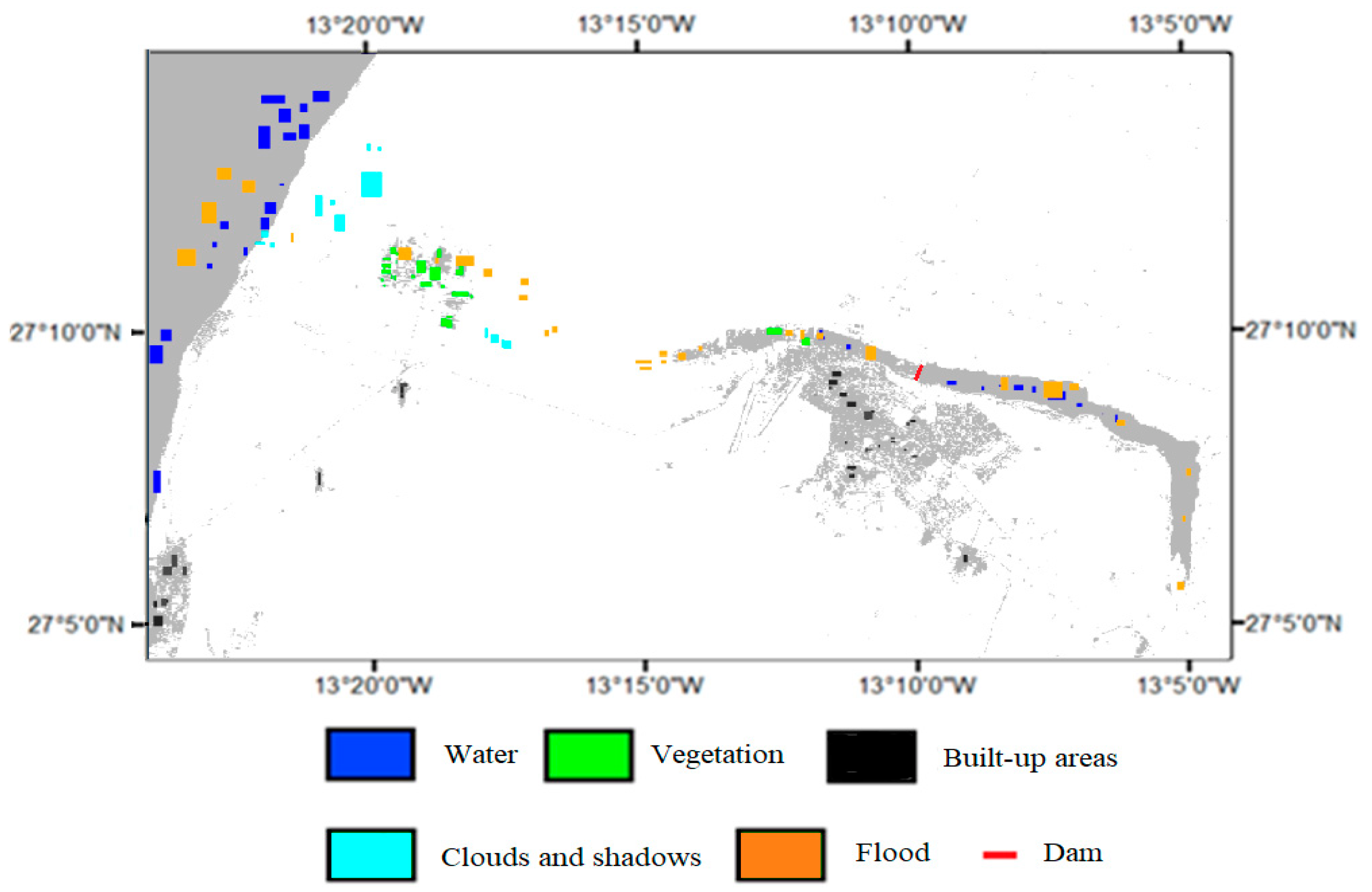
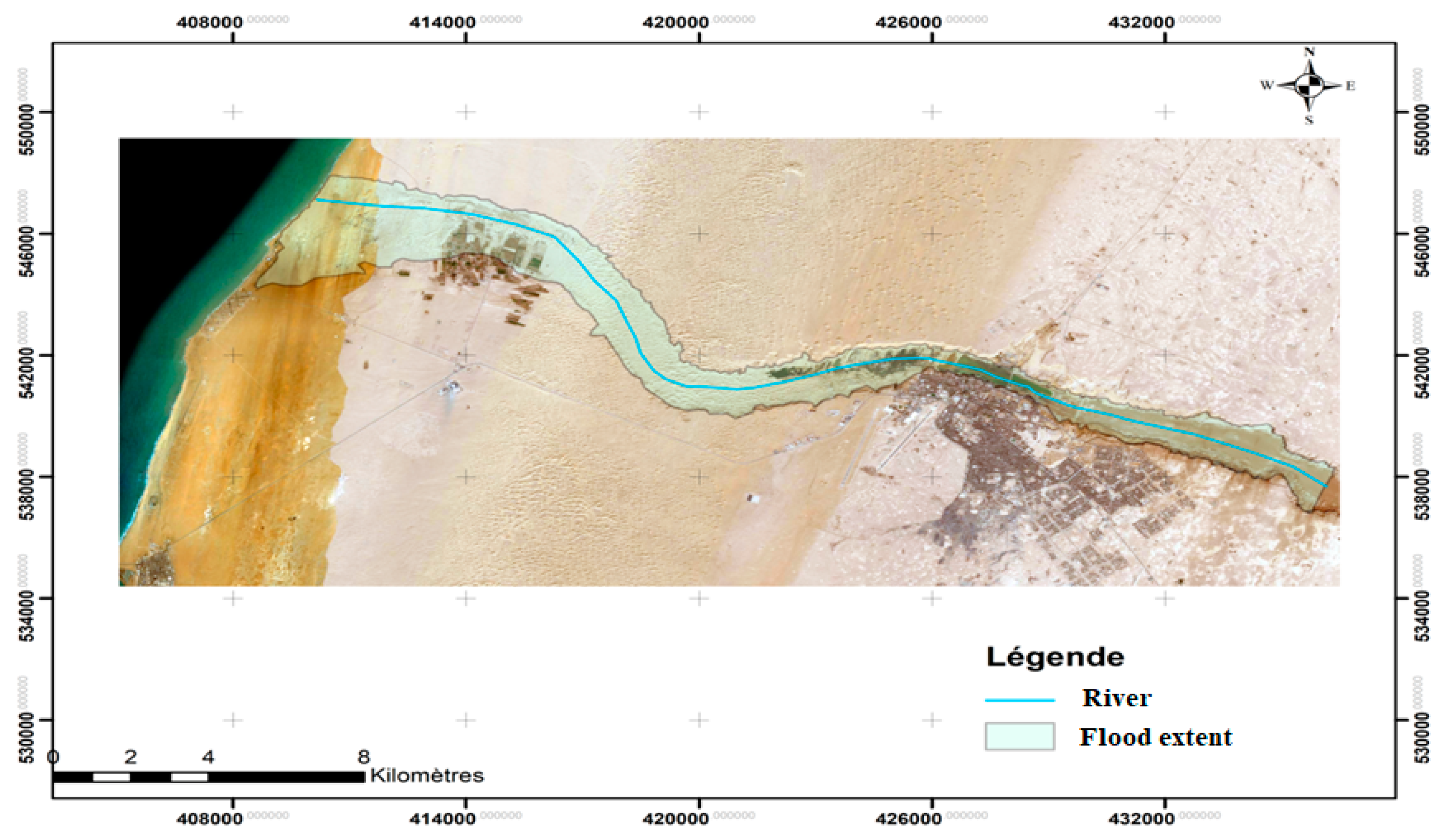
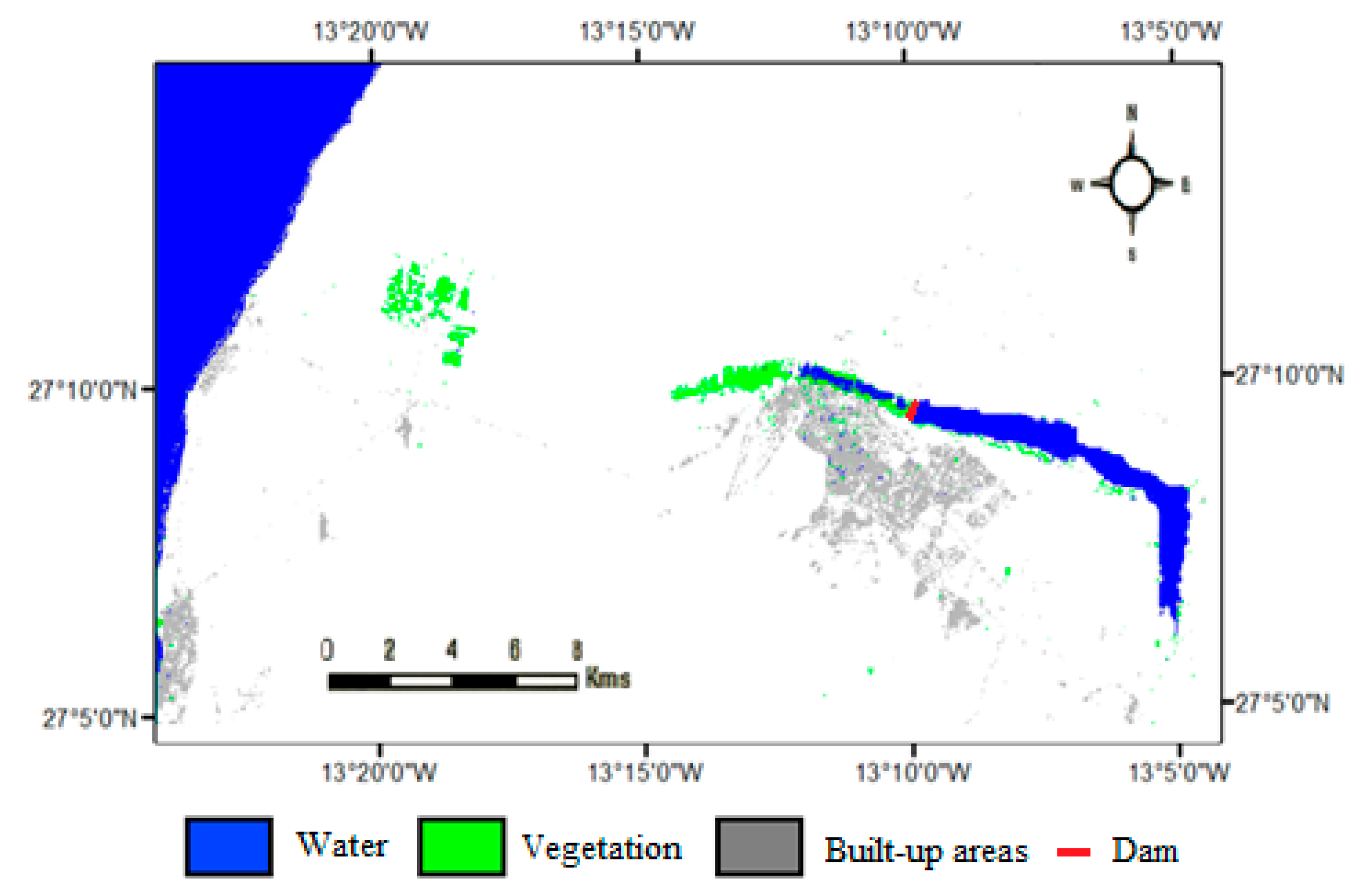
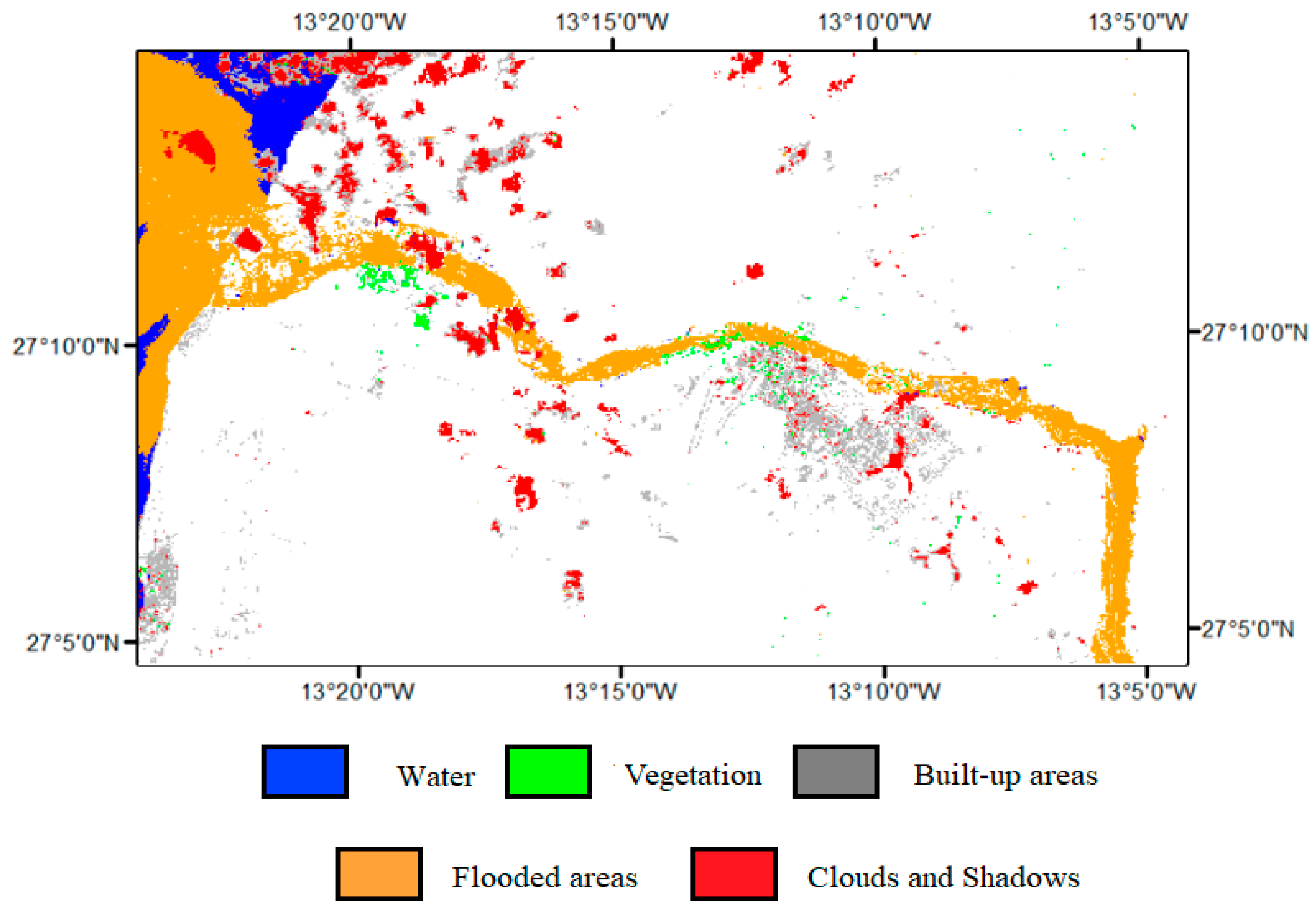
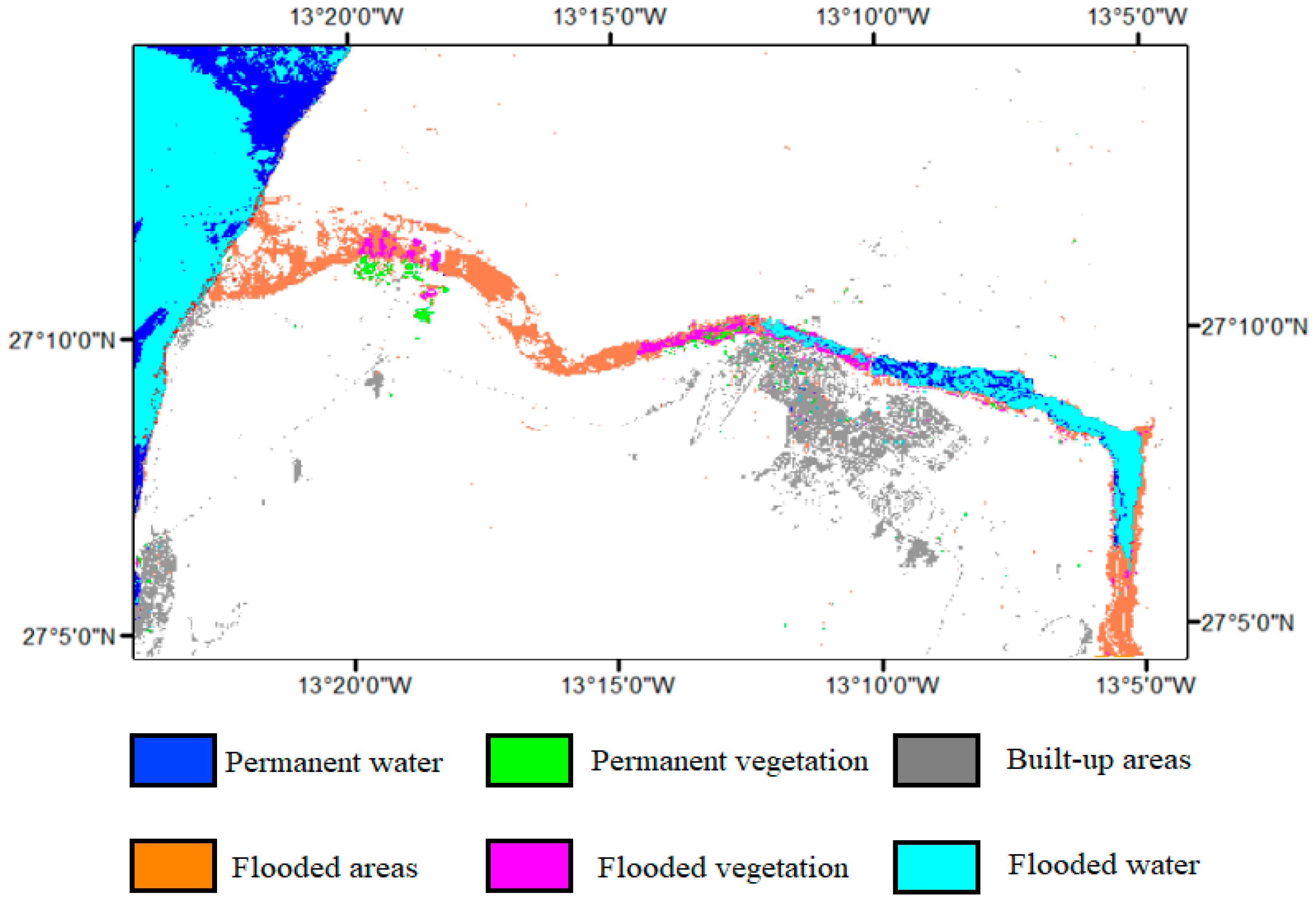
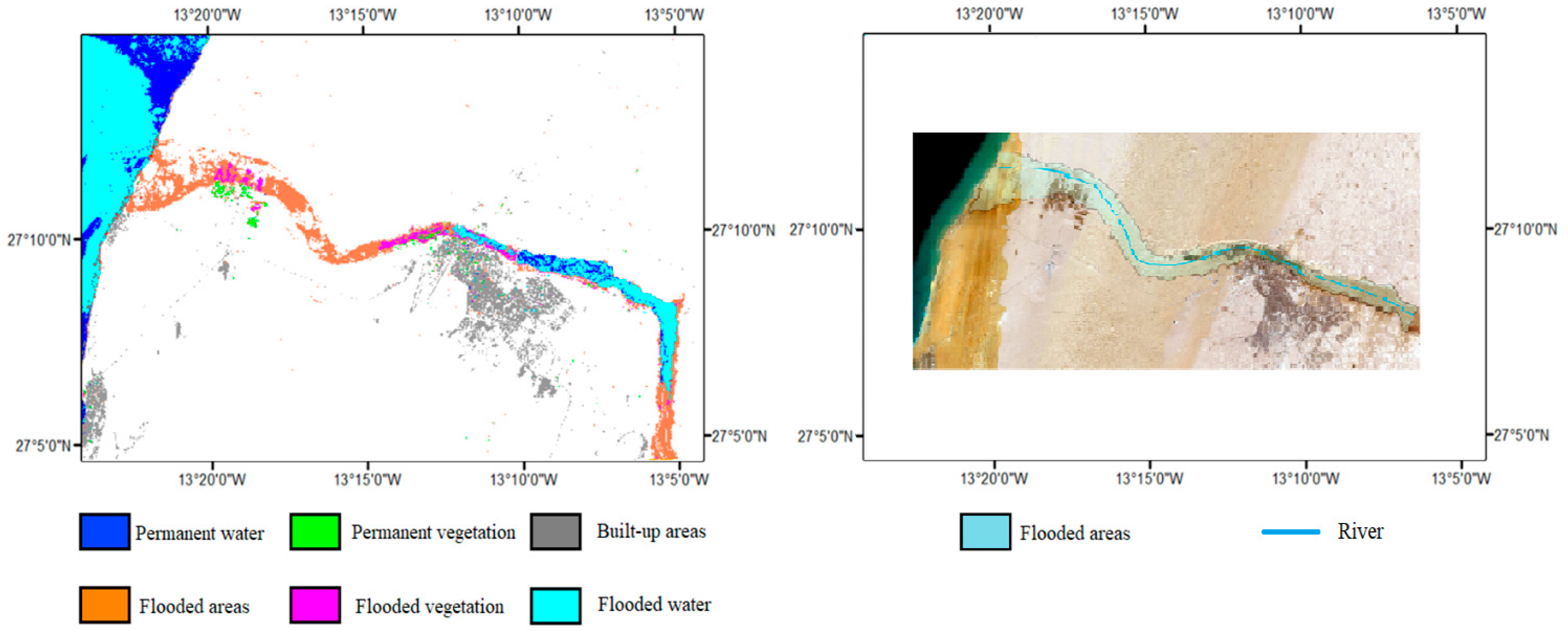
3.2. Remote Sensing Mapping
4. Conclusions
Author Contributions
Funding
Data Availability Statement
Acknowledgments
Conflicts of Interest
References
- Chapi, K.; Singh, V.P.; Shirzadi, A.; Shahabi, H.; Bui, D.T.; Pham, B.T.; Khosravi, K. A novel hybrid artificial intelligence approach for flood susceptibility assessment. Environ. Model. Softw. 2017, 95, 229–245. [Google Scholar] [CrossRef]
- Pradhan, B. Flood susceptible mapping and risk area delineation using logistic regression, GIS and remote sensing. J. Spat. Hydrol. 2010, 9, 2. [Google Scholar]
- Tien Bui, D.; Khosravi, K.; Li, S.; Shahabi, H.; Panahi, M.; Singh, V.P.; Chapi, K.; Shirzadi, A.; Panahi, S.; Chen, W.; et al. New Hybrids of ANFIS with Several Optimization Algorithms for Flood Susceptibility Modeling. Water 2018, 10, 1210. [Google Scholar] [CrossRef]
- Alfieri, L.; Bisselink, B.; Dottori, F.; Naumann, G.; de Roo, A.; Salamon, P.; Wyser, K.; Feyen, L. Global projections of river flood risk in a warmer world. Earth’s Future 2017, 5, 171–182. [Google Scholar] [CrossRef]
- Abdessamed, D.; Abderrazak, B. Coupling HEC-RAS and HEC-HMS in rainfall–runoff modeling and evaluating floodplain inundation maps in arid environments: Case study of Ain Sefra city, Ksour Mountain. SW of Algeria. Environ. Earth Sci. 2019, 78, 586. [Google Scholar] [CrossRef]
- Jenson, S.K.; Domingue, J.O. Extracting topographic structure from digital elevation data for geographic information system analysis. Photogramm. Eng. Remote Sens. 1988, 54, 1593–1600. [Google Scholar]
- Wilson, J.P.; Gallant, J.C. (Eds.) Terrain Analysis: Principles and Applications; John Wiley & Sons: Hoboken, NJ, USA, 2000. [Google Scholar]
- Dawadi, S.; Ahmad, S. Changing climatic conditions in the Colorado River Basin: Implications for water resources management. J. Hydrol. 2012, 430–431, 127–141. [Google Scholar] [CrossRef]
- Mosquera-Machado, S.; Ahmad, S. Flood hazard assessment of Atrato River in Colombia. Water Resour. Manag. 2006, 21, 591–609. [Google Scholar] [CrossRef]
- Ahmad, S.; Simonovic, S.P. An Intelligent Decision Support System for Management of Floods. Water Resour. Manag. 2006, 20, 391–410. [Google Scholar] [CrossRef]
- Zhang, X.; Srinivasan, R.; Debele, B.; Hao, F. Runoff Simulation of the Headwaters of the Yellow River Using The SWAT Model with Three Snowmelt Algorithms. JAWRA J. Am. Water Resour. Assoc. 2008, 44, 48–61. [Google Scholar] [CrossRef]
- Wheater, H.S.; Jolley, T.J.; Onof, C.; Mackay, N.; Chandler, R.E. Analysis of aggregation and disaggregation effects for grid-based hydrological models and the development of improved precipitation disaggregation procedures for GCMs. Hydrol. Earth Syst. Sci. 1999, 3, 95–108. [Google Scholar] [CrossRef][Green Version]
- Verma, A.K.; Jha, M.K.; Mahana, R.K. Evaluation of HEC-HMS and WEPP for simulating watershed runoff using remote sensing and geographical information system. Paddy Water Environ. 2010, 8, 131–144. [Google Scholar] [CrossRef]
- Arnold, J.G.; Srinivasan, R.; Muttiah, R.S.; Williams, J.R. Large area hydrologic modeling and assessment part i: Model development. JAWRA J. Am. Water Resour. Assoc. 1998, 34, 73–89. [Google Scholar] [CrossRef]
- Shahabi, H.; Shirzadi, A.; Ghaderi, K.; Omidvar, E.; Al-Ansari, N.; Clague, J.J.; Geertsema, M.; Khosravi, K.; Amini, A.; Bahrami, S.; et al. Flood Detection and Susceptibility Mapping Using Sentinel-1 Remote Sensing Data and a Machine Learning Approach: Hybrid Intelligence of Bagging Ensemble Based on K-Nearest Neighbor Classifier. Remote Sens. 2020, 12, 266. [Google Scholar] [CrossRef]
- Lee, S.; Kim, J.-C.; Jung, H.-S.; Lee, M.J.; Lee, S. Spatial prediction of flood susceptibility using random-forest and boosted-tree models in Seoul metropolitan city, Korea. Geomat. Nat. Hazards Risk 2017, 8, 1185–1203. [Google Scholar] [CrossRef]
- Chen, W.; Hong, H.; Li, S.; Shahabi, H.; Wang, Y.; Wang, X.; Ahmad, B.B. Flood susceptibility modelling using novel hybrid approach of reduced-error pruning trees with bagging and random subspace ensembles. J. Hydrol. 2019, 575, 864–873. [Google Scholar] [CrossRef]
- Chen, W.; Li, Y.; Xue, W.; Shahabi, H.; Li, S.; Hong, H.; Wang, X.; Bian, H.; Zhang, S.; Pradha, B.; et al. Modeling flood susceptibility using data-driven approaches of naïve bayes tree, alternating decision tree, and random forest methods. Sci. Total Environ. 2020, 701, 134979. [Google Scholar] [CrossRef]
- Mohammadi, A.; Kamran, K.V.; Karimzadeh, S.; Shahabi, H.; Al-Ansari, N. Flood Detection and Susceptibility Mapping Using Sentinel-1 Time Series, Alternating Decision Trees, and Bag-ADTree Models. Complexity 2020, 2020, 4271376. [Google Scholar] [CrossRef]
- Khosravi, K.; Pham, B.T.; Chapi, K.; Shirzadi, A.; Shahabi, H.; Revhaug, I.; Prakash, I.; Bui, D.T. A comparative assessment of decision trees algorithms for flash flood susceptibility modeling at Haraz watershed, northern Iran. Sci. Total Environ. 2018, 627, 744–755. [Google Scholar] [CrossRef]
- Janizadeh, S.; Avand, M.; Jaafari, A.; Van Phong, T.; Bayat, M.; Ahmadisharaf, E.; Prakash, I.; Pham, B.T.; Lee, S. Prediction Success of Machine Learning Methods for Flash Flood Susceptibility Mapping in the Tafresh Watershed, Iran. Sustainability 2019, 11, 5426. [Google Scholar] [CrossRef]
- Tehrany, M.S.; Pradhan, B.; Jebur, M.N. Flood susceptibility mapping using a novel ensemble weights-of-evidence and support vector machine models in GIS. J. Hydrol. 2014, 512, 332–343. [Google Scholar] [CrossRef]
- Liong, S.Y.; Sivapragasam, C. Flood stage forecasting with support vector machines. J. Am. Water Resour. Assoc. 2002, 38, 173–186. [Google Scholar] [CrossRef]
- Tehrany, M.S.; Pradhan, B.; Mansor, S.; Ahmad, N. Flood susceptibility assessment using GIS-based support vector machine model with different kernel types. CATENA 2015, 125, 91–101. [Google Scholar] [CrossRef]
- Gianinetto, M.; Villa, P. Mapping Hurricane Katrina’s widespread destruction in New Orleans using multisensor data and the normalized difference change detection (NDCD) technique. Int. J. Remote Sens. 2011, 32, 1961–1982. [Google Scholar] [CrossRef]
- Drusch, M.; Del Bello, U.; Carlier, S.; Colin, O.; Fernandez, V.; Gascon, F.; Hoersch, B.; Isola, C.; Laberinti, P.; Martimort, P.; et al. Sentinel-2: ESA’s Optical High-Resolution Mission for GMES Operational Services. Remote Sens. Environ. 2012, 120, 25–36. [Google Scholar] [CrossRef]
- Gary, W.B. Hec-Ras River Analysis System Hydraulic Reference Manual Version 4.1, Rabat, Rapport Scientfique. Available online: https://www.hec.usace.army.mil/software/hec-ras/documentation/HEC-RAS_4.1_Reference_Manual.pdf (accessed on 1 January 2020).
- Iosub, M.; Minea, O.; Hapciuc, I.; Romanescu, G.H. The Use of Hec-Ras Modelling in Flood Risk Analysis. 2016. Available online: https://www.researchgate.net/publication/275648572 (accessed on 1 January 2020).
- Tucker, C.J. Red and photographic infrared linear combinations for monitoring vegetation. Remote Sens. Environ. 1979, 8, 127–150. [Google Scholar] [CrossRef]
- Cortes, C.; Vapnik, V. Support-vector networks. Mach Learn. 1995, 20, 273–297. [Google Scholar] [CrossRef]
- Echogdali, F.Z.; Boutaleb, S.; Jauregui, J.; Elmouden, A. Cartography of flooding hazard in semi-arid climate: The case of Tata Valley (South-East of Morocco). J. Geogr. Nat. Disasters 2018, 8, 1000214. [Google Scholar]
- Shao, Z.; Fu, H.; Fu, P.; Yin, L. Mapping Urban Impervious Surface by Fusing Optical and SAR Data at the Decision Level. Remote Sens. 2016, 8, 945. [Google Scholar] [CrossRef]


| Satellite | Instrument | Acquisition Date | Use |
|---|---|---|---|
| Sentinel 2 | MSI | 20 October 2016 | One week before flash-flood event; used to calculate reference image |
| Sentinel 2 | MSI | 30 October 2016 | One day after the flash-flood event; used for flood-extent mapping |
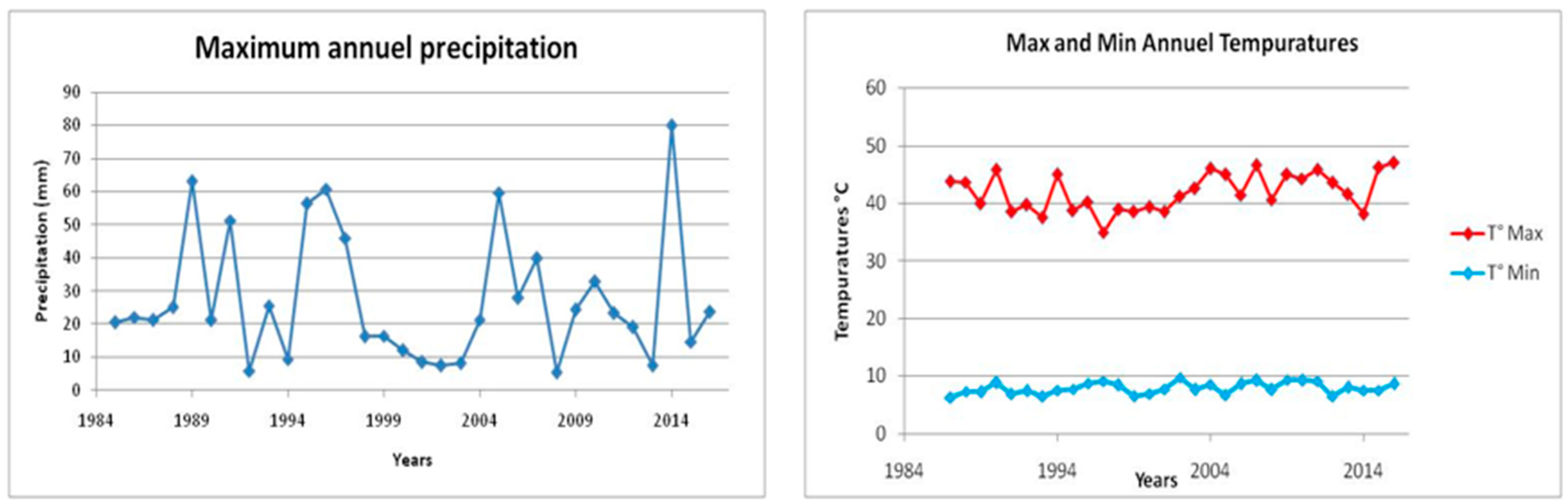
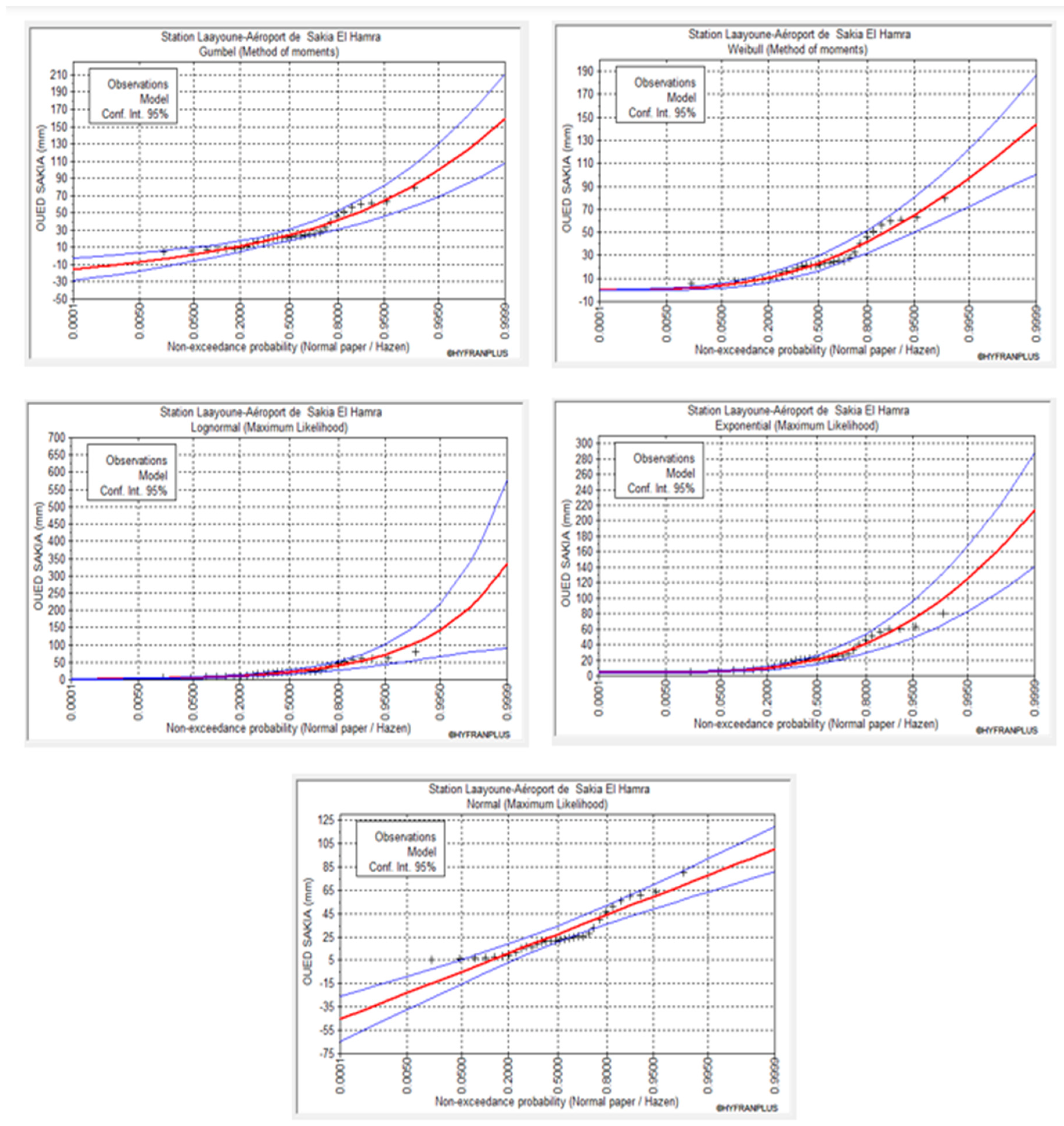
| Return Period (Years) | Precipitation (mm) | Confidence at 95% | |
|---|---|---|---|
| 100.0 | 153 | 95.7 | 211 |
| 50.0 | 127 | 83.6 | 171 |
| 20.0 | 96.7 | 67.8 | 126 |
| 10.0 | 75.6 | 55.7 | 95.4 |
| 5.0 | 56.1 | 43.4 | 68.8 |
| 2.0 | 31.7 | 25.6 | 37.9 |
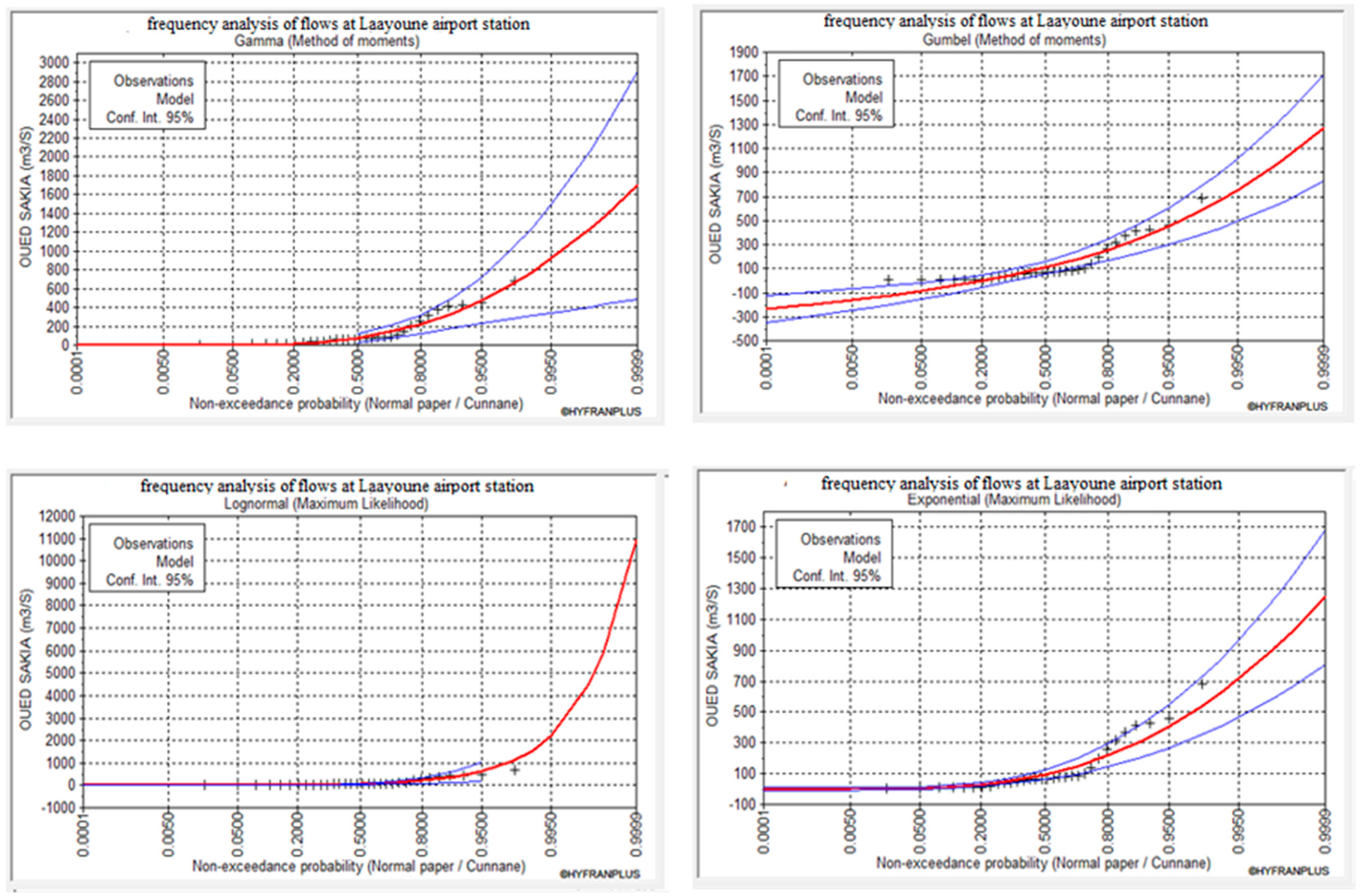
| Return Period (Years) | Qmax (m3/s) | Confidence at 95% | |
|---|---|---|---|
| 100.0 | 1570 | 1491.5 | 1644.575 |
| 50.0 | 1070 | 1016.5 | 1120.825 |
| 20.0 | 608 | 577.6 | 636.88 |
| 10.0 | 366 | 347.7 | 383.385 |
| 5.0 | 198 | 188.1 | 207.405 |
| 2.0 | 61.4 | 58.33 | 64.3165 |
Publisher’s Note: MDPI stays neutral with regard to jurisdictional claims in published maps and institutional affiliations. |
© 2022 by the authors. Licensee MDPI, Basel, Switzerland. This article is an open access article distributed under the terms and conditions of the Creative Commons Attribution (CC BY) license (https://creativecommons.org/licenses/by/4.0/).
Share and Cite
Nafia, E.-A.; Sebbar, B.; Bouras, E.H.; Moumni, A.; Laftouhi, N.-E.; Lahrouni, A. Hydraulic Modeling and Remote Sensing Monitoring of Floodhazard in Arid Environments—A Case Study of Laayoune City in Saquia El Hamra Watershed Southern Morocco. Water 2022, 14, 3582. https://doi.org/10.3390/w14213582
Nafia E-A, Sebbar B, Bouras EH, Moumni A, Laftouhi N-E, Lahrouni A. Hydraulic Modeling and Remote Sensing Monitoring of Floodhazard in Arid Environments—A Case Study of Laayoune City in Saquia El Hamra Watershed Southern Morocco. Water. 2022; 14(21):3582. https://doi.org/10.3390/w14213582
Chicago/Turabian StyleNafia, El-Alaouy, Badreddine Sebbar, El Houssaine Bouras, Aicha Moumni, Nour-Eddine Laftouhi, and Abderrahman Lahrouni. 2022. "Hydraulic Modeling and Remote Sensing Monitoring of Floodhazard in Arid Environments—A Case Study of Laayoune City in Saquia El Hamra Watershed Southern Morocco" Water 14, no. 21: 3582. https://doi.org/10.3390/w14213582
APA StyleNafia, E.-A., Sebbar, B., Bouras, E. H., Moumni, A., Laftouhi, N.-E., & Lahrouni, A. (2022). Hydraulic Modeling and Remote Sensing Monitoring of Floodhazard in Arid Environments—A Case Study of Laayoune City in Saquia El Hamra Watershed Southern Morocco. Water, 14(21), 3582. https://doi.org/10.3390/w14213582