
Factors Affecting the Rates and Modes of Landslide Colluvium Removal in River Channels of Podhale (Western Carpathians)


Abstract
1. Introduction
2. Study Area
3. Methods
Hydrological Conditions of the Studied C-RCZs in Years 2013–2019
4. Results
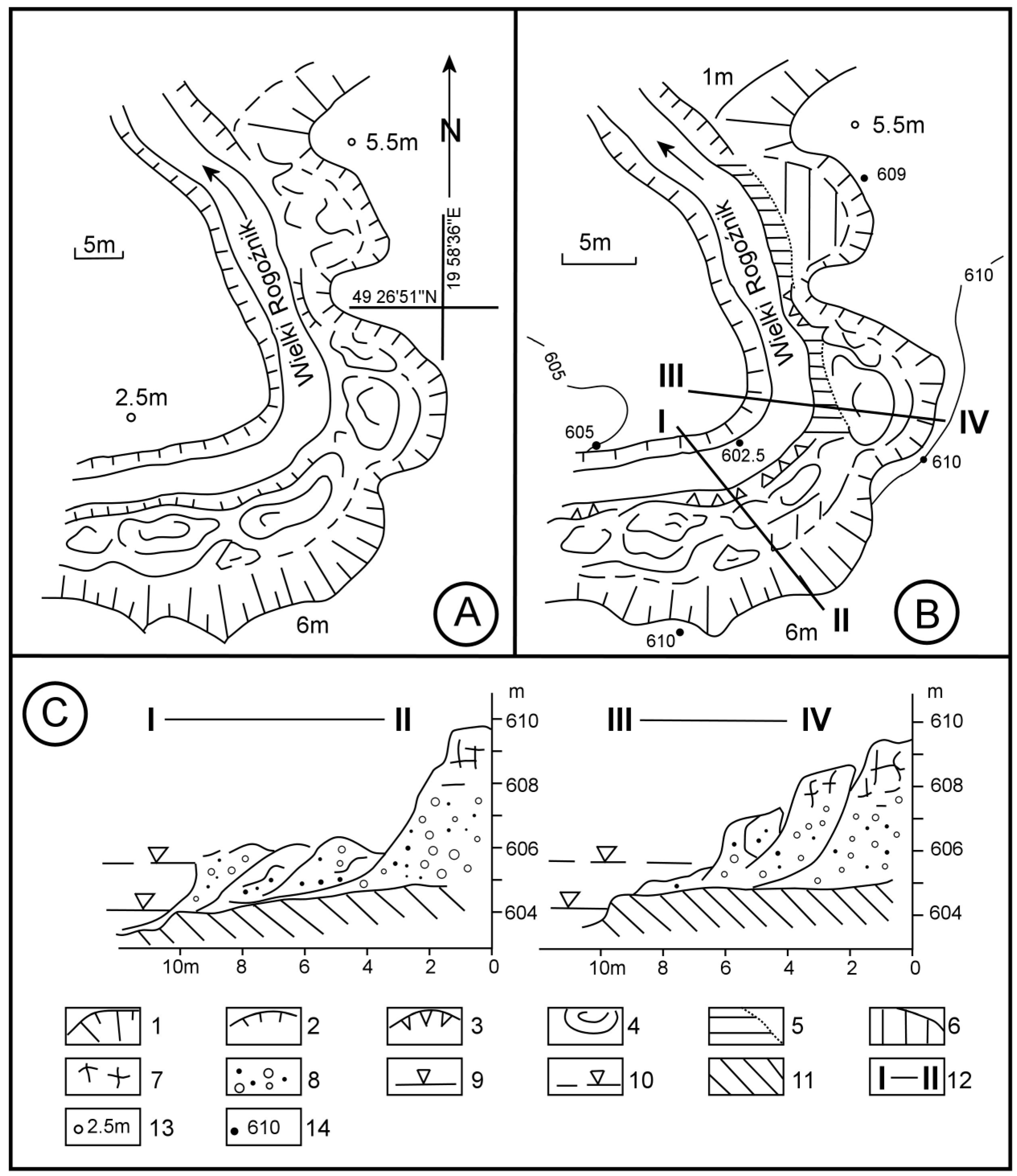
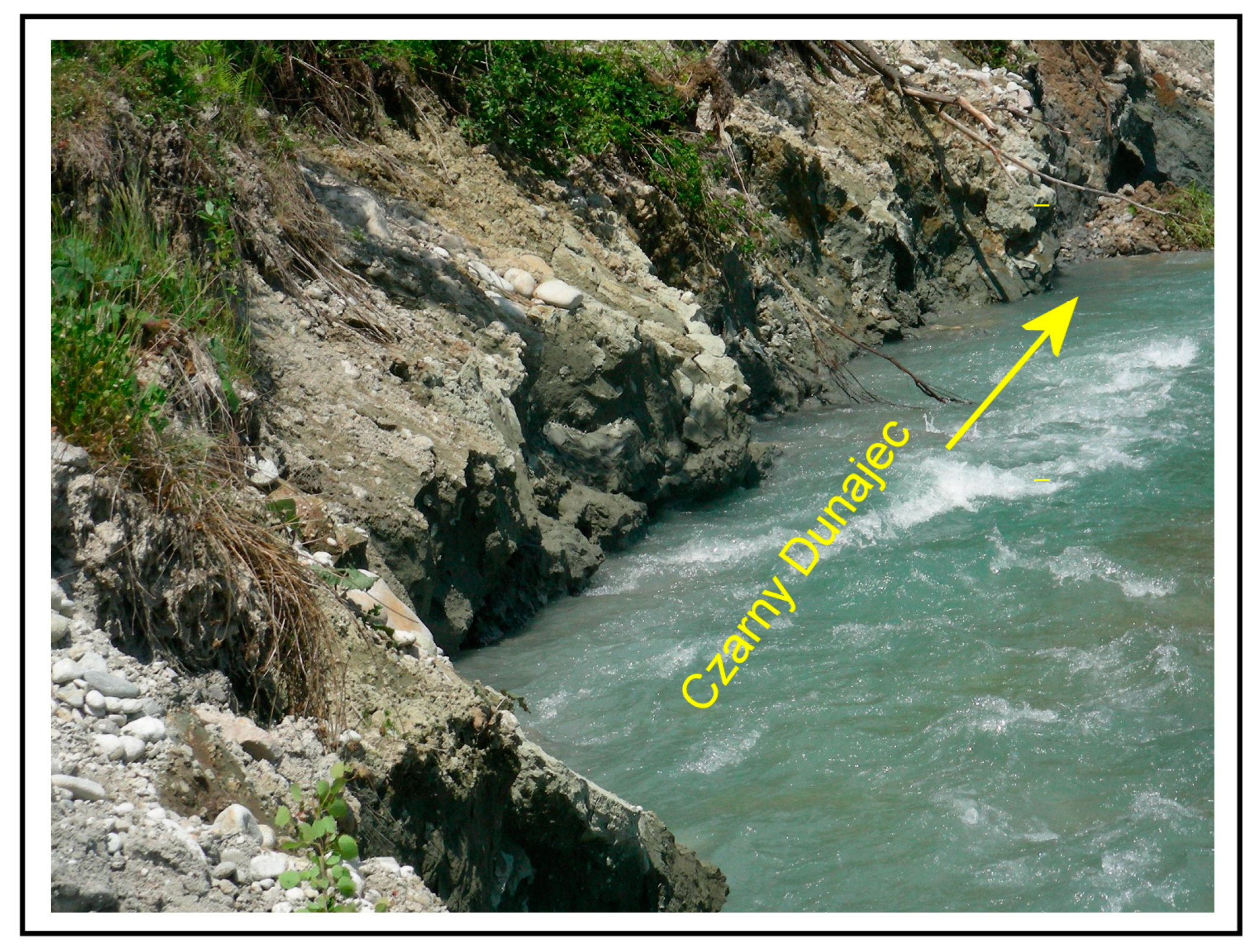
4.1. The Landslides
4.2. The Course and Amounts of Colluvium Erosion at the Study Sites in Years 2013–2019
4.3. The Amount and Course of Colluvium Erosion in 2019
5. Disccusion
6. Conclusions
Author Contributions
Funding
Institutional Review Board Statement
Informed Consent Statement
Data Availability Statement
Conflicts of Interest
References
- Ohmori, H. Dynamics and erosion rate of the river running on a thick deposit supplied by a large landslide. Z. Geomorphol. Suppl. 1992, 36, 129–140. [Google Scholar] [CrossRef]
- Owczarek, P. Transformacja Koryt Rzecznych w Warunkach Dostawy Grubofrakcyjnego Materiału Stokowego (na Przykładzie Średniogórskich Dopływów Odry i Wisły); Wydawnictwo Uniwersytetu Śląskiego: Katowice, Poland, 2007; Volume 2510, pp. 1–133. [Google Scholar]
- Owczarek, P. Hillslope deposits in gravel-bed rivers and their effects on the evolution of alluvial channel forms: A case study from the Sudetes and Carpathian Mountains. Geomorphology 2008, 98, 111–125. [Google Scholar] [CrossRef]
- Strużyński, A.; Kulesza, K.; Strutyński, M. Bed Stability as a Parameter Describing the Hydromorphological Balance of a Mountain River. In Experimental and Computational Solutions of Hydraulic Problems; GeoPlanet: Earth and Planetary Sciences; Rowinski, P., Ed.; Springer: Berlin/Heidelberg, Germany, 2013; pp. 249–251. [Google Scholar]
- Dziuban, J. Osuwisko Połoma. Czas. Geogr. 1983, 54, 369–376. [Google Scholar]
- Costa, J.E.; Schuster, R.L. Documented historical landslide dams from around the world. U.S. Geol. Surv. Open File Rep. 1991, 91–239, 1–486. [Google Scholar]
- Clague, J.J.; Evans, S.G. Formation and Failure of Natural Dams in the Canadian Cordillera. Bull. Geol. Surv. Can. 1994, 464, 1–44. [Google Scholar]
- Hewitt, K. Catastrophic landslides and their effects on the Upper Indus streams, Karakoram Himalaya, northern Pakistan. Geomorphology 1998, 26, 47–80. [Google Scholar] [CrossRef]
- Casagli, N.; Ermini, L. Geomorphic analysis of landslide dams in the Northern Apennine. Jpn. Geomorphol. Union Trans. 1999, 20, 219–249. [Google Scholar]
- Haczewski, G.; Kukulak, J. Early Holocene landslide-dammed lake in the Bieszczady mountains (Polish East Carpathians) and its evolution. Studia Geomorphol. Carpatho-Balc. 2004, 17, 61–85. [Google Scholar]
- Panek, T.; Smolková, V.; Hradecký, J.; Sedláček, J.; Zernitskaya, V.; Kadlec, J.; Pazdur, A.; Řehánek, T. A Late-Holocene evolution of a floodplain impounded by the Smrdutá landslide, Carpathians Mountains (Czech Republic). Holocene 2013, 23, 218–229. [Google Scholar] [CrossRef]
- Schneider, J.F.; Gruber, F.E.; Mergili, M. Recent cases and geomorphic evidence of landslide-dammed lakes and related hazards in the mountains of Central Asia. In Proceedings of the Second World Landslide Forum, Rome, Italy, 3–9 October 2011; pp. 1–6. [Google Scholar]
- Griffiths, G.A.; McSaveney, M.J. Sedimentation and river containment on Waitangitaona alluvial fan—South Westland, New Zealand. Z. Geomorphol. 1986, 30, 215–230. [Google Scholar] [CrossRef]
- Aipassa, M.I. Landslide Debris Movement and its Effects on Slope and River Channel in Mountainous Watershed. Res. Bull. Coll. Exp. For. 1991, 48, 375–418. [Google Scholar]
- Hovius, N.; Stark, C.P.; Allen, P.A. Sediment flux from a mountain belt derived from landslide mapping. Geology 1997, 25, 231–234. [Google Scholar] [CrossRef]
- Oszczypko, N.; Golonka, J.; Zuchiewicz, W. Osuwisko w Lachowicach (Beskidy Zachodnie): Skutki powodzi z 2001 r. Przegląd Geol. 2001, 50, 893–898. [Google Scholar]
- Othman, A.; Gloaguen, R. River Courses Affected by Landslides and Implications for Hazard Assessment: A High Resolution Remote Sensing Case Study in NE Iraq–W Iran. Remote Sens. 2013, 5, 1024–1044. [Google Scholar] [CrossRef]
- Korup, O. Landslide-induced river channel avulsions in mountain catchments of southwest New Zealand. Geomorphology 2004, 63, 57–80. [Google Scholar] [CrossRef]
- Korup, O. Geomorphic imprint of landslides on alpine river systems, southwest New Zealand. Earth Surf. Processes Landf. 2005, 30, 783–800. [Google Scholar] [CrossRef]
- Cebulski, J. Human impact on the change of direction of river channel migration caused by formation of a landslide dam. Studia Geomorphol. Carpatho-Balc. 2016, 50, 5–17. [Google Scholar]
- Sah, M.P.; Mazari, R.K. Anthropogenically accelerated mass movement, Kulu Valley, Himachal Pradesh, India. Geomorphology 1998, 26, 123–138. [Google Scholar] [CrossRef]
- Paul, S.K.; Bartarya, S.K.; Rautela, P.; Mahajan, A.K. Catastrophic mass movement of 1998 monsoons at Malpa in Kali Valley, Kumaun Himalaya, India. Geomorphology 2000, 35, 169–180. [Google Scholar] [CrossRef]
- Lévy, S.; Jaboyedoff, M.; Locat, J.; Demers, D. Erosion and channel change as factors of landslides an valley formation in Champlain Sea Clays: The Chacoura River, Quebec, Canada. Geomorphology 2012, 145–146, 12–18. [Google Scholar] [CrossRef]
- Dauksza, L.; Kotarba, A. An analysis of the influence of fluvial erosion in the development of a landslides slope (using the application of the queueing theory). Studia Geomorphol. Carpatho-Balc. 1973, 7, 91–104. [Google Scholar]
- Alexandrowicz, S.W. Subfosylna malakofauna z osuwiska w Piwnicznej (Polskie Karpaty Fliszowe). Folia Quat. 1985, 56, 79–99. [Google Scholar]
- Margielewski, W. Landslide forms on Połoma Mountain in the Sine Wiry Nature Reserve, West Bieszczady. Ochr. Przyr. 1991, 49, 23–29. [Google Scholar]
- Margielewski, W. Wpływ ruchów masowych na współczesną ewolucję rzeźby Karpat fliszowych.W. In Współczesne Przemiany Rzeźby Polski; Starkel, L., Kotarba, A., Kostrzewski, A., Krzemień, K., Eds.; Instytut Geografii i Gospodarki Przestrzennej UJ.: Kraków, Poland, 2008; pp. 69–80. [Google Scholar]
- Cebulski, J. Współoddziaływanie osuwisk i koryt rzecznych w polskich Karpatach fliszowych. Ph.D. Thesis, Polska Akademia Nauk, Kraków, Poland, 2021. [Google Scholar]
- Cebulski, J. Impact of river erosion on variances in colluvial movement and type for landslides in the Polish Outer Carpathians. Catena 2022, 217, 106415. [Google Scholar] [CrossRef]
- Tyszkowski, S. Badania rozwoju osuwisk w rejonie Świecia, na podstawie materiałów fotogrametrycznych. Landf. Anal. 2008, 9, 385–389. [Google Scholar]
- Banach, M.; Kaczmarek, H.; Tyszkowski, S. Rozwój osuwiska w strefie brzegowej sztucznych zbiorników wodnych na przykładzie osuwiska centralnego w Dobrzyniu nad Wisłą, zbiornik włocławski. Przegląd Geogr. 2013, 85, 397–415. [Google Scholar] [CrossRef]
- Teisseyre, H. Materiały do znajomości osuwisk w niektórych okolicach Karpat i Podkarpacia. Rocz. PTG 1936, 12, 133–192. [Google Scholar]
- Gil, E. Monitoring ruchów osuwiskowych. In Zintegrowany Monitoring Środowiska Przyrodniczego; Monitoring Geoekosystemów Górskich: Szymbark, Poland, 1995; pp. 120–130. [Google Scholar]
- Bober, L.; Thiel, K.; Zabuski, L. Zjawiska osuwiskowe w polskich Karpatach Fliszowych. In Geologiczno-Inżynierskie Właściwości Wybranych Osuwisk; Wydawnictwo IBW PAN: Gdańsk, Poland, 1997; pp. 1–102. [Google Scholar]
- Zydroń, T.; Gruchot, A. Wpływ opadu deszczu i erozji bocznej na stateczność na przykładzie osuwiska w Bieśniku (Beskid Niski). Acta Sci. Pol. Archit. 2016, 15, 149–161. [Google Scholar]
- Williams, D.R.; Romeril, P.M.; Mitchell, R.J. Riverbank erosion and recession in the Ottawa area. Can. Geotech. J. 1979, 16, 641–650. [Google Scholar] [CrossRef]
- Fletcher, L.; Hungr, O.; Evans, S.G. Contrasting failure behaviour of two large landslides in clay and silt. Can. Geotech. J. 2002, 39, 46–62. [Google Scholar] [CrossRef]
- Ouimet, W.B.; Whipple, K.X.; Royden, L.H.; Sun, Z.; Chen, Z. The influence of large landslides on river incision in a transient landscape: Eastern margin of the Tibetan Plateau (Sichuan, China). GSA Bull. 2007, 119, 1462–1476. [Google Scholar] [CrossRef]
- Boengiu, S.; Simulescu, D.; Oana, I.; Popescu, L. River undercutting and inducedlandslide hazard. The Jiu River valley (Romania) as case study. Geomorphol. Slovaca Bohem. 2011, 2, 46–58. [Google Scholar]
- Cui, P.; Dang, C.; Zhuang, J.Q.; You, Y.; Chen, X.Q.; Scott, K.M. Landslide-dammed lake at Tangjiashan, Sichuan province, China (triggered by the Wenchuan Earthquake, May 12, 2008): Risk assessment, mitigation strategy, and lessons learned. Environ. Earth Sci. 2012, 65, 1055–1065. [Google Scholar] [CrossRef]
- Wen, B.P.; Aydin, A.; Duzgoren-Aydin, N.S.; Li, Y.R.; Chen, H.Y.; Xiao, S.D. Residual strength of slip zones of large landslides in the Three Gorges area, China. Eng. Geol. 2007, 93, 82–98. [Google Scholar] [CrossRef]
- Zyndroń, T. Ocena właściwości wytrzymałościowych gruntów z wykorzystaniem analizy wstecznej na przykładzie jednego z osuwisk na zboczu Wiatrówki (Beskid Niski). Acta Sci. Pol. Form. Circumiectus 2016, 15, 139–150. [Google Scholar]
- Staromłyńska, K.; Zydroń, T. Badania wytrzymałości resztkowej gruntów spoistych z terenów osuwiskowych okolic Szymbarku k. Gorlic. Acta. Sci. Pol. Form. Circumiectus 2017, 16, 173–185. [Google Scholar] [CrossRef]
- Zhang, Y.; Guo, C.; Yang, Z.; Shen, Y.; Wu, R.; Ren, S. Study on shear strength of deep-seated sliding zone soil of zhouchangping landslide in Maoxian, Sichuan. J. Eng. Geol. 2021, 29, 764–776. [Google Scholar]
- Kukulak, J.; Augustowski, K. Landslides on river banks in the western part of Podhale (Central Carpathians). Geol. Q. 2016, 60, 561–571. [Google Scholar] [CrossRef]
- Cebulak, E. Wpływ sytuacji synoptycznej na maksymalne opady dobowe w dorzeczu górnej Wisły. Folia Geogr. Ser. Geogr. Phys. 1992, 22, 82–95. [Google Scholar]
- Niedźwiedź, T.; Obrębska-Starklowa, B. Klimat. In Dorzecze Górnej Wisły. Vol 1; Dynowska, I., Maciejowski, M., Eds.; Państwowe Wydawnictwo Naukowe: Warszawa, Kraków, 1991; pp. 68–84. [Google Scholar]
- Obrębska-Starklowa, B.; Hess, M.; Olecki, Z.; Trepińska, J.; Kowanetz, L. Klimat. In Karpaty Polskie; Warszyńska, J., Ed.; Wyd. UJ: Kraków, Poland, 1995; pp. 31–47. [Google Scholar]
- Cebulska, M. Wieloletnia zmienność maksymalnych opadów dobowych w Kotlinie Orawsko–Nowotarskiej (1984–2013). Czas. Inżynierii Lądowej Sr. Archit. 2015, 62, 49–60. [Google Scholar] [CrossRef]
- Hess, M.; Leśniak, B.; Rauczyńska-Olecka, D. Stosunki klimatyczno-bonitacyjne obszaru Podhala. Zesz. Nauk. UJ Pr. Geogr. 1984, 58, 7–63. [Google Scholar]
- Augustowski, K.; Kukulak, J. Rates of Frost erosion in River banks with different particie size (West Carpathians, Poland). Geogr. Fis. Din. Quat. 2017, 40, 5–17. [Google Scholar]
- Punzet, J. Zmienność przepływu wód powierzchniowych Tatr I Podhala. Probl. Zagospod. Ziem Górskich 1981, 22, 155–169. [Google Scholar]
- Niedźwiedź, T. Extreme precipitation events on the northern side of the Tatra Mountains. Geogr. Pol. 2003, 76, 13–21. [Google Scholar]
- Żmudzka, E. Contemporary climate changes in the high mountain part of the Tatras. Misc. Geogr. 2011, 15, 93–102. [Google Scholar] [CrossRef]
- Dynowska, I. Reżim odpływu rzecznego, plansza 32.3 Odpływ rzeczny. In Atlas Rzeczpospolitej Polskiej; IG PZ PAN, PPWK im E. Romera S.A: Warszawa, Poland, 1994. [Google Scholar]
- Olszak, J.; Kukulak, J.; Alexanderson, H. Revision of river terrace geochronology in the Orawa-Nowy Targ Depresion, south Poland: Insights from OSL dating. Proc. Geol. Assoc. 2016, 127, 595–605. [Google Scholar] [CrossRef]
- Krzemień, K. Zmienność subsystemu korytowego Czarnego Dunajca. Zesz. Nauk. Uniw. Jagiellońskiego Pr. Geogr. 1981, 53, 123–137. [Google Scholar]
- Birkenmajer, K. Przewodnik Geologiczny po Pienińskim Pasie Skałkowym; Wydawnictwa Geologiczne: Warszawa, Poland, 1979; 236p. [Google Scholar]
- Michalik, A. Osuwisko w Cichem na Podhalu. Rocznik Nauk. Dydakt. WSP Krakowie 1962, 10, 49–56. [Google Scholar]
- Bartarya, S.K.; Sah, M.P. Landslide induced river bed uplift in the Tal Valley of Garhwal Himalaya, India. Geomorphology 1995, 12, 109–121. [Google Scholar] [CrossRef]
- Millet, D. River Erosion, Landslides and Slope Development in Göta River. Master’s Thesis, Chalmers University of Technology, Göteborg, Sweden, 2011; 91p. [Google Scholar]
- Bartnik, W. Hydraulika potoków i rzek górskich z dnem ruchomym—Początek ruchu rumowiska wleczonego. Zesz. Nauk. Akad. Rol. Krakowie 1992, 171, 122. [Google Scholar]
- Ziętara, T. Rola gwałtownych ulew i powodzi w modelowaniu rzeźby Beskidów. Prace Geogr. Inst. Geogr. PAN 1968, 60, 1–116. [Google Scholar]
- Harvey, A.M. The influence of sediment supply on the channel morphology of upland streams: Howgill Fells, Northwest England. Earth Surf. Processes Landf. 1991, 16, 675–684. [Google Scholar] [CrossRef]
- Harvey, A.M. Coupling between hillslopes and channels in upland fluvial systems: Implications for landscape sensitivity, illustrated from the Howgill Fells, Nortwest England. Catena 2001, 42, 225–250. [Google Scholar] [CrossRef]
- Karmaker, T.; Dutta, S. Erodibility of fine soil from the composite river bank of Brahmaputra in India. Hydrol. Processes 2011, 25, 104–111. [Google Scholar] [CrossRef]
- Göransson, G.; Hedfors, J.; Ndayikengurukiye, G.; Odén, K. Climate change induced river erosion as a trigger for landslide. In Proceedings of the 17th Nordic Geotechnical Meeting, Reykjavik, Island, 25–28 May 2016; Volume 1–2, pp. 1182–1192. [Google Scholar]
- Thiel, K.; Zabuski, L. Wytrzymałość na ścinanie masywów skalnych fliszu karpackiego. Pr. Nauk. Inst. Geotech. Hydrot. PWroc. 1995, 36, 330–336. [Google Scholar]
- Kaczyński, R. Warunki Geologiczno-Inżynierskie na Obszarze Polski; Państwowy Instytut Geologiczny-Państwowy Instytut Badawczy: Warszawa, Poland, 2017; 398p. [Google Scholar]
- Julian, J.P.; Torres, R. Hydraulic erosion of cohesive riverbanks. Geomorphology 2006, 76, 193–206. [Google Scholar] [CrossRef]
- Demonik, A. (Ed.) Właściwości Wytrzymałościowe i Odkształceniowe skał. Centralne Karpaty Zachodnie. Cz. 5 (14). Objaśnienia i interpretacja; Wyd. Zakł. Geomechaniki IHiGI UW: Warszawa, Poland, 2012; 77p. [Google Scholar]
- Weeb, R.H.; Melis, T.S.; Griffiths, P.G.; Elliott, J.G. Reworking of Aggraded Debris fans. In The Controlled flood in Grand Canyon; Geophysical Monograph Series; AGU: Washington, DC, USA, 1999; Volume 110, pp. 37–51. [Google Scholar]
- Malet, J.-P.; Maquaire, O.; Locat, J.; Remaître, A. Assessing debris flow hazard associated with slow moving landslides: Methodology and numerical analyses. Landslides 2004, 1, 83–90. [Google Scholar] [CrossRef]
- Lawler, D.M.; Grove, J.R.; Couperthwaite, J.S.; Leeks, G.J.L. Downstream change in river bank erosion rates in the Swale–Ouse system, northern England. Hydrol. Processes 1995, 13, 977–992. [Google Scholar] [CrossRef]
- Kim, Y.S.; Wang, Y.M. Landslide Analysis of River Bank Affected by Water Level Fluctuation I. J. Korean Geosynth. Soc. 2010, 9, 77–85. [Google Scholar]
- Iverson, J.P.; Torres, R. Landslide trigeriing by rain infiltration. Water Resour. Res. 2000, 36, 1897–1910. [Google Scholar] [CrossRef]
- Barla, G.; Antolini, F.; Barla, M. Slope stabilization in difficult conditions: The case study of a debris in NW Italian Alps. Landslides 2013, 10, 343–355. [Google Scholar] [CrossRef]
- Banach, M. Dynamika brzegów dolnej Wisły. Dok. Geogr. 1998, 9, 92. [Google Scholar]
- Henshaw, A.J.; Thorne, C.R.; Clifford, N.J. Identifying Causes and Controls of River Bank Erosion in a British Upland Catchment. Catena 2013, 100, 107–119. [Google Scholar] [CrossRef]


| Study Sites (1–4) | Elevation of Channel Floor (m a.s.l.) | Channel Gradient (‰) | Maximum Water Level (cm) | Mean Annual Discharge (m3/s) | Channel Width (m) | Position of Flow Relative to Landslide Front |
|---|---|---|---|---|---|---|
| Czarny Dunajec (1) | 739–737 | 12.5 | 2.15 | 4.38 | 40–60 | diagonal |
| Wlk. Rogoźnik (2) | 602.5–600 | 3.0 | 1.55 | 2.0 | 8–12 | transverse/diagonal |
| Bystry (3) | 666–663 | 11.0 | 1.35 | 1.1 * | 7–10 | transverse |
| Cichy (4) | 788–770 | 32.1 | 1.30 | 0.5 * | 5–8 | parallel |
| Site | Volume of Colluvium Removed from the Landslide Fronts (m3) | |||||||
|---|---|---|---|---|---|---|---|---|
| 2013 | 2014 | 2015 | 2016 | 2017 | 2018 | 2019 | Total | |
| Chochołów (1) | 15 | 26 | 18 | 19 | 21 | 14 | 17 | 130 |
| Ludźmierz (2) | 4 | 8 | 4 | 4 | 7 | 7 | 9 | 43 |
| Czerwona Góra (3) | - | 33 | 14 | 15 | 25 | 33 | 27 | 147 |
| Ciche (4) | 4 | 7 | 4 | 5 | 8 | 6 | 7 | 41 |
| Total (1 + 4) | 33 | 74 | 40 | 43 | 61 | 60 | 60 | 361 |
| Site | Volume of Colluvium Removed from the Landslide Fronts (m3) | ||||||
|---|---|---|---|---|---|---|---|
| 20.01–9.02 | 22.02–12.03 | 29.04–22.05 | 19.06 | 11–15.08 | 09–10.09 | Total | |
| Chochołów (1) | 1.5 | 2 | 3.5 | 3 | 4 | 1.5 | 15.5 |
| Ludźmierz (2) | 1 | 2 | 2 | 0.5 | 1.5 | 0.5 | 7.5 |
| Czerwona Góra (3) | 2.5 | 3.5 | 5 | 3 | 5.5 | 3.5 | 23 |
| Grapa (4) | 1 | 1.5 | 1.5 | 0.5 | 1 | 0.5 | 6 |
| Total (1 + 4) | 6 | 9 | 12 | 7 | 12 | 6 | 52 |
Publisher’s Note: MDPI stays neutral with regard to jurisdictional claims in published maps and institutional affiliations. |
© 2022 by the authors. Licensee MDPI, Basel, Switzerland. This article is an open access article distributed under the terms and conditions of the Creative Commons Attribution (CC BY) license (https://creativecommons.org/licenses/by/4.0/).
Share and Cite
Kukulak, J.; Augustowski, K.; Olszak, J. Factors Affecting the Rates and Modes of Landslide Colluvium Removal in River Channels of Podhale (Western Carpathians). Water 2022, 14, 3577. https://doi.org/10.3390/w14213577
Kukulak J, Augustowski K, Olszak J. Factors Affecting the Rates and Modes of Landslide Colluvium Removal in River Channels of Podhale (Western Carpathians). Water. 2022; 14(21):3577. https://doi.org/10.3390/w14213577
Chicago/Turabian StyleKukulak, Józef, Karol Augustowski, and Janusz Olszak. 2022. "Factors Affecting the Rates and Modes of Landslide Colluvium Removal in River Channels of Podhale (Western Carpathians)" Water 14, no. 21: 3577. https://doi.org/10.3390/w14213577
APA StyleKukulak, J., Augustowski, K., & Olszak, J. (2022). Factors Affecting the Rates and Modes of Landslide Colluvium Removal in River Channels of Podhale (Western Carpathians). Water, 14(21), 3577. https://doi.org/10.3390/w14213577