Article

Driving Mechanisms of the Evolution and Ecological Water Demand of Hulun Lake in Inner Mongolia

1
Key Laboratory of Groundwater Sciences and Engineering, Ministry of Natural Resources, Shijiazhuang 050061, China
2
Institute of Hydrogeology and Environmental Geology, Chinese Academy of Geological Sciences, Shijiazhuang 050061, China
3
Manzhouli College, Inner Mongolia Agricultural University, Hohhot 010018, China
*
Author to whom correspondence should be addressed.
Water 2022, 14(21), 3415; https://doi.org/10.3390/w14213415
Submission received: 16 August 2022 / Revised: 25 October 2022 / Accepted: 25 October 2022 / Published: 27 October 2022
(This article belongs to the Section Ecohydrology)

Abstract

:
Hulun Lake is located in the Hulun Buir Grassland in Inner Mongolia and is an important component of the northern ecological barrier of China. Fluctuations in its area directly affect the stability of the surrounding ecological environments. In this study, Hulun Lake was taken as the study object, and meteorological data, water body area, water level, reservoir capacity, runoff volume, and social statistical data were used to study the dynamic changes in Hulun Lake and the critical driving forces. We constructed a balance analysis equation, determined the role of groundwater in the water cycle, and examined the minimum ecological water demand of Hulun Lake. The results of the analyses revealed that during the last 55 years, the variation trends of the water level, area, and reservoir capacity were generally consistent and could be divided into six stages. The increased temperature decreased precipitation, and increased evaporation resulted in decreased water flow from the major rivers supplying the lake, which was the main cause of the decrease in the water level and area of Hulun Lake. Groundwater was involved in the water cycle of Hulun Lake. After deducting the seepage and surface drainage, we found that the groundwater recharge volume was around 792 million m3 yearly. Based on the environmental, ecological, and production functions of Hulun Lake, the minimum ecological water demand is 11.272 billion m3.

1. Introduction

Lakes are one of the most important resources for ensuring human survival and supporting the development of human societies, and they are valuable natural ecological assets in a region. Lakes play an important role in sustaining water supply, conserving soil and water, preventing floods and droughts, regulating climate, and maintaining biodiversity [1,2]. They are an integral part of the terrestrial hydrosphere and participate in the water cycle, which is prominent and important in arid and semi-arid regions. China has large arid and semi-arid regions, accounting for one-third of the country’s area. These include large parts of northwestern China. Lakes play an indispensable role in this region’s hydrologic cycle, water balance, and water resource regulation [3,4].
In recent years, climate warming and irrational development by humans have resulted in threats to or even the disappearance of several inland lakes [5,6]. Since the 20th century, the number of lakes globally has been nearly halved, and lake environments have been deeply affected by natural and human factors, which have also affected the lake water balance. Therefore, identifying the evolution patterns of lakes has become an international research hotspot. Studying the dynamic changes in the lake area and water level, investigating the evolutionary pattern of lakes and analyzing their driving factors (natural and social), as well as reasonably estimating the ecological water demand, can help to address the ecological environment problems in the basin caused by shrinking lake area and declining water level. Furthermore, the water demand of regional ecosystems can be determined from these studies, thereby providing a scientific basis for the rational allocation of water resources and ecological restoration in the region [7].
A variety of factors may cause lake evolution. As natural and social anthropogenic factors are the primary reasons, it is necessary to analyze the driving factors to understand the lake’s dynamic changes. Scholars from China and overseas have conducted studies on different aspects. Some scholars have studied the dynamic changes associated with lakes in climate change [8,9,10]. With the development of remote sensing technology, many scholars have conducted dynamic monitoring of lakes and obtained similar results [11,12]. Regarding the study of lake wetlands, some scholars have focused on the changes in the ecological functions of lakes and attempted to find the primary drivers of these changes. However, research scholars hold different views and argue that the changes in lakes in different regions are driven by different factors [13,14,15,16,17,18].
International research on ecological water demand started with river ecosystems [19]. Before the 1990s, focusing on in-stream flow, the research considered the water demand of navigation for aquatic organisms, such as fish. There was no clear concept of ecological water demand [20,21]. After the 1990s, different studies considered not only the in-stream flow but also ecosystem water demand, as the integrity of the ecosystem was given greater attention. Ecological water demand has been explored extensively [22,23,24], and in the 21st century, it remains one of the hot issues studied by international scholars. The studies were not limited to the ecological water demand of rivers, as that of other ecosystems, such as lakes and wetlands, were also considered. Moreover, geographic information technology has been applied to research on ecological water demand [25]. In China, ecological water demand research started late, although it has rapidly developed. Although there is still no universal definition of ecological water demand, its connotation has improved, and its determination in different ecosystems has become more accurate. In recent years, a growing number of scholars have investigated the ecological water demand of ecosystems, such as rivers, lakes, and vegetation, using GIS, RS, and other geographic information technology tools, to estimate ecological water demand for different target years based on different ecological protection objectives [26,27,28,29,30].
The Hulun Lake National Nature Reserve is known as the ‘kidney’ of the Hulun Buir grassland. It is a rare natural lake wetland ecosystem with good biodiversity and ecological functions in the cold and arid regions of the world. This nature reserve has an area of around 7400 km2. Hulun Lake nourishes the surrounding grasslands, regulates the entire grassland climate, jointly serves as an ecological barrier with the Da Hinggan Range in northeastern China, and plays an indispensable role in the ecological security of northeastern and northern China [31]. However, the hydrological processes in the Hulun Lake drainage basin have been greatly affected by human activities in recent times. As a result, there is a severe impairment of the ecological and hydrological processes in the drainage basin and severe degradation of the ecological environment, which have manifested as a decrease in the water level and area of Hulun Lake, as well as grassland desertification and degradation [32]. Li et al. [33] constructed a water balance model to quantitatively analyze the variations in the water level of Hulun Lake. Zhao et al. [34] and Yang et al. [35] found that a decrease in the lake area will result in a decrease in the surrounding vegetation cover and primary productivity, as well as an increase in the desertification area. Wu [36] used the analytic hierarchy process to construct a system for evaluating the ecosystem health of Hulun Lake and assessed the health of the wetland ecosystem. He found that the Hulun Lake wetland is in a sub-healthy state. Han et al. [37] found that the continuous decrease in the water volume has resulted in the gradual worsening of the aquatic environment, and the lake currently exhibits moderate eutrophication.
The changes in Hulun Lake are one of the environmental problems affecting inland lakes in arid regions. The Hulun Lake drainage basin is located in China, Mongolia, and Russia, and the related information has yet to be systematically reported, posing problems in studies related to Hulun Lake. In this study, Hulun Lake in Inner Mongolia was selected as the study object, and the limited available data were used to analyze the historical evolution of Hulun Lake. Herein, we investigated the critical forces driving the dynamic changes in Hulun Lake, constructed a lake water balance analysis equation, determined the specific role of groundwater, and analyzed the water balance to identify the mechanisms driving the evolution of Hulun Lake under the current conditions. The minimum ecological water demand of Hulun Lake was also examined. The results of this study provide a scientific basis for the conservation and ecological restoration of the Hulun Lake wetland.

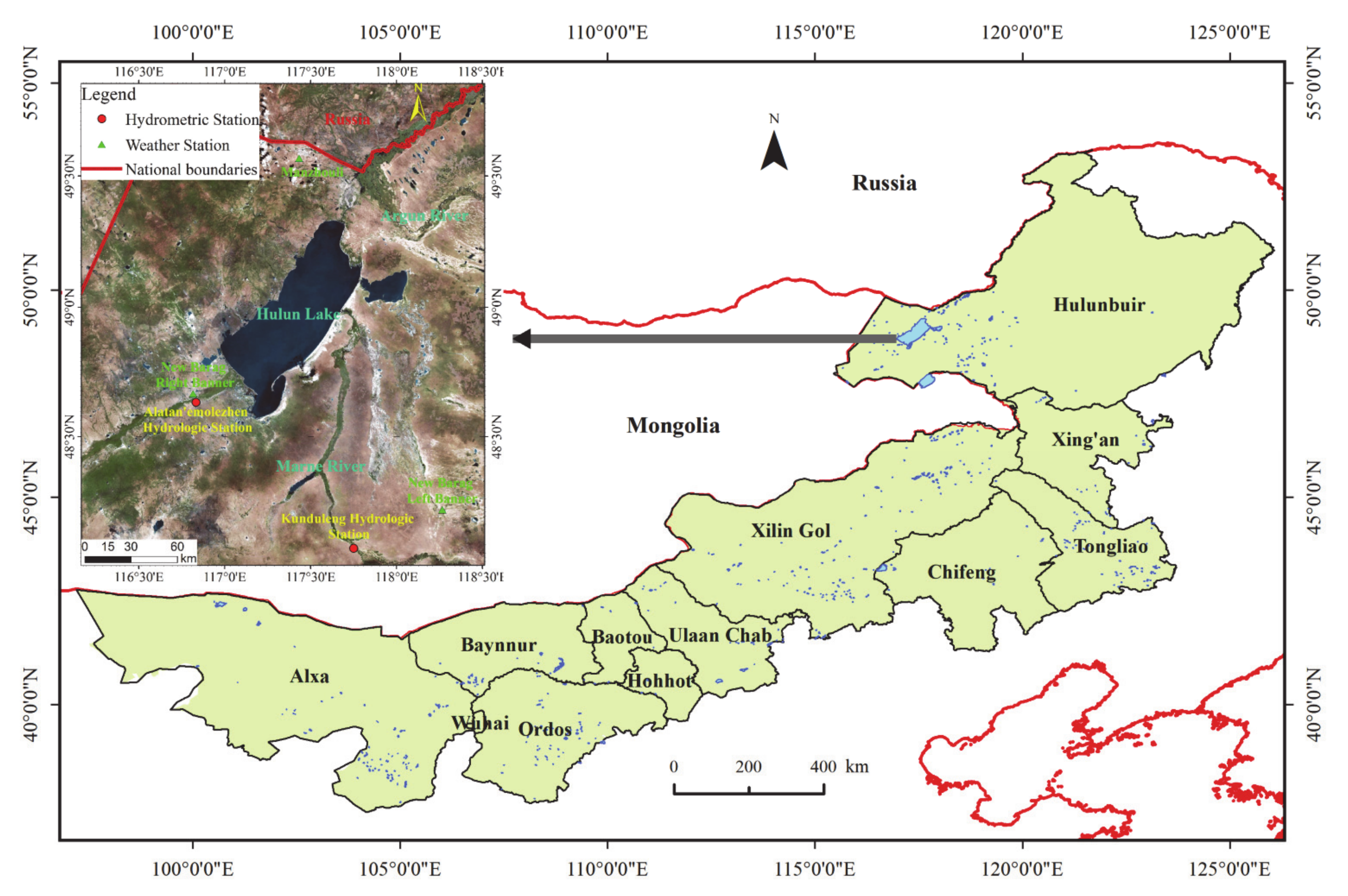
2. Description of the Study Area

Hulun Lake is also known as Dalai Nor. It is the fifth-largest lake in China and the largest lake in Inner Mongolia [38,39]. It is located between Manzhouli in Hulun Buir, New Barag Right Banner, and New Barag Left Banner in the Inner Mongolia Autonomous Region. Hulun Lake is in the middle of the Hulun Buir Grassland (116°58′–117°48′ E, 48°33′–49°20′ N) (Figure 1). The shape of the lake is an irregular rectangle with a northeast-southwest long axis. The length, mean width, mean water depth, and maximum water depth (i.e., when the lake water level is at its maximum) are 93 km, 25 km, 5–6 m, and 8 m, respectively. Recently, the maximum lake area has reached 2339 km2, and the maximum volume has reached 13.8 billion m3.
The Hulun Lake water system is part of the Argun river system [40,41], which includes Hulun Lake, Buir Lake, Kelulun River, Wuerxun River, Khalkh River, Shaerlejin River, Dalaneluomu River, Wulan Lake, and New Dalai Lake (Xinkai Lake). This system comprises 3, 13, and 64 rivers of >1000 km, 20–100 km, and <20 km lengths, respectively. The entire river basin is 2374.9 km long and has an area (within China) of 37,214 km2.
Hulun Lake is located in a high-latitude area in southeastern Eurasia. It is situated at the intersection between oceanic and continental climates, and it has a temperate semi-arid continental monsoon climate. The main characteristics of the region are as follows: long and cold winters with a long snow cover period, short and mild summers with low precipitation, dry and windy summers, a drastic drop in temperature during autumn, and a short frost-free period. The annual mean, maximum extreme, and minimum extreme temperature values are −0.1 °C, 40.1 °C, and −42.7 °C, respectively. The mean annual precipitation is 262.48 mm, mainly from June to September, accounting for 76% of the annual precipitation. The annual evaporation, the snow cover period, and the mean wind speed are 1400–1900 mm, 140 days, and 4.2 m/s, respectively.

3. Materials and Methods

3.1. Data Sources

The meteorological data used in this study were obtained from the China Meteorological Administration data-sharing website. The mean annual meteorological data from three weather stations in the New Barag Right Banner, New Barag Left Banner, and Manzhouli were used, including annual temperature and precipitation values for 1959–2017 and daily values of evaporation for 1960–2011. The social data were obtained from the Inner Mongolia Statistics Bureau, and the mean statistical data for 2000–2014 for the New Barag Right Banner, New Barag Left Banner, and Manzhouli were used, including livestock population, gross industrial output value, and gross agricultural output value. The runoff volume data for the Wuerxun River and Kelulun River were obtained from the annual runoff volume data recorded at Kunduleng hydrologic station and Alatan’emolezhen hydrologic station from 1963–2014. The annual ingress runoff data into Hulun Lake were collected from 1960–2011. The annual water area, water level, and reservoir capacity data for Hulun Lake for 1962–2016 were measurement data provided by the Inner Mongolia Agricultural University and remote sensing monitoring and estimated data.

3.2. Research Methodology

3.2.1. Water Balance Analysis

Water balance refers to a time period in which the difference between outgoing and incoming lake water is equal to the variable of lake storage in that time period, which can be expressed by the water balance equation [42]:
ΔV/Δt = A(h)(P − E) + Qin + Qout,
where Δt denotes the calculation time period (day, month, year), and ΔV is the change in storage capacity of lakes (m3). When there is more water at the end of the time period than at the beginning, ΔV is positive, and vice versa. A represents the lake surface area (m2), and A denotes a function of the water level (h). P denotes the lake surface rainfall (mm), and the average value of three meteorological stations in New Barag Left Banner, New Barag Right Banner, and Manzhouli is taken as the lake surface rainfall. E is the evaporation amount of the lake surface (mm). The evaporation amount of Hulun Lake in this study is derived by multiplying the evaporation amount observed at the three nearby meteorological stations (New Barag Left Banner, New Barag Right Banner, and Manzhouli) by the conversion factor of 0.61, which is the scaling factor calculated by Chong Li et al. [33] using the penman formula. Qin denotes the amount of water entering the lake (m3), which primarily includes river runoff entering the lake, slope runoff, and groundwater recharge. Qout denotes the amount of water leaving the lake (m3), which is the discharge and seepage of the lake.

3.2.2. Ecological Water Demand

The minimum ecological water requirement of the lake is the minimum threshold value required to provide a specific quantity of water of certain quality to the lake ecosystem to protect freshwater resources and restore the ecological function of lakes. This ensures that the lake ecosystem can continuously supply freshwater resources for human life and production to curb the lake’s deteriorating ecological environment. According to the functional method, ecological water demand can be expressed as [43]:
W = (WP + WE) + Qt + Wq + Wb + Max(Wh,Wz,Qsp) + Max(Wr,Wf),
where W is the water demand of the wetland ecosystem; WP + WE is the water demand of wetland evaporation; Qt is the water demand of soil; Wq is the water demand of biological habitat; Wb is the water demand of groundwater recharge; Wh is the water demand of river ecosystem; Wz is the water demand of river self-purification; Qsp is the water demand of river sand transport; Wr is the water demand of shallow sea ecosystem; and Wf is the water demand of shoreline erosion prevention.
Considering the current ecological condition of Hulun Lake, the minimum ecological water demand of the lake is the sum of the minimum water demand to prevent salinization of the lake and the water demand required for the tourism of the nature reserve and the production at the Jalainur coal mine and the living of workers there.

4. Results

4.1. Analysis of Lake Evolution and Driving Force

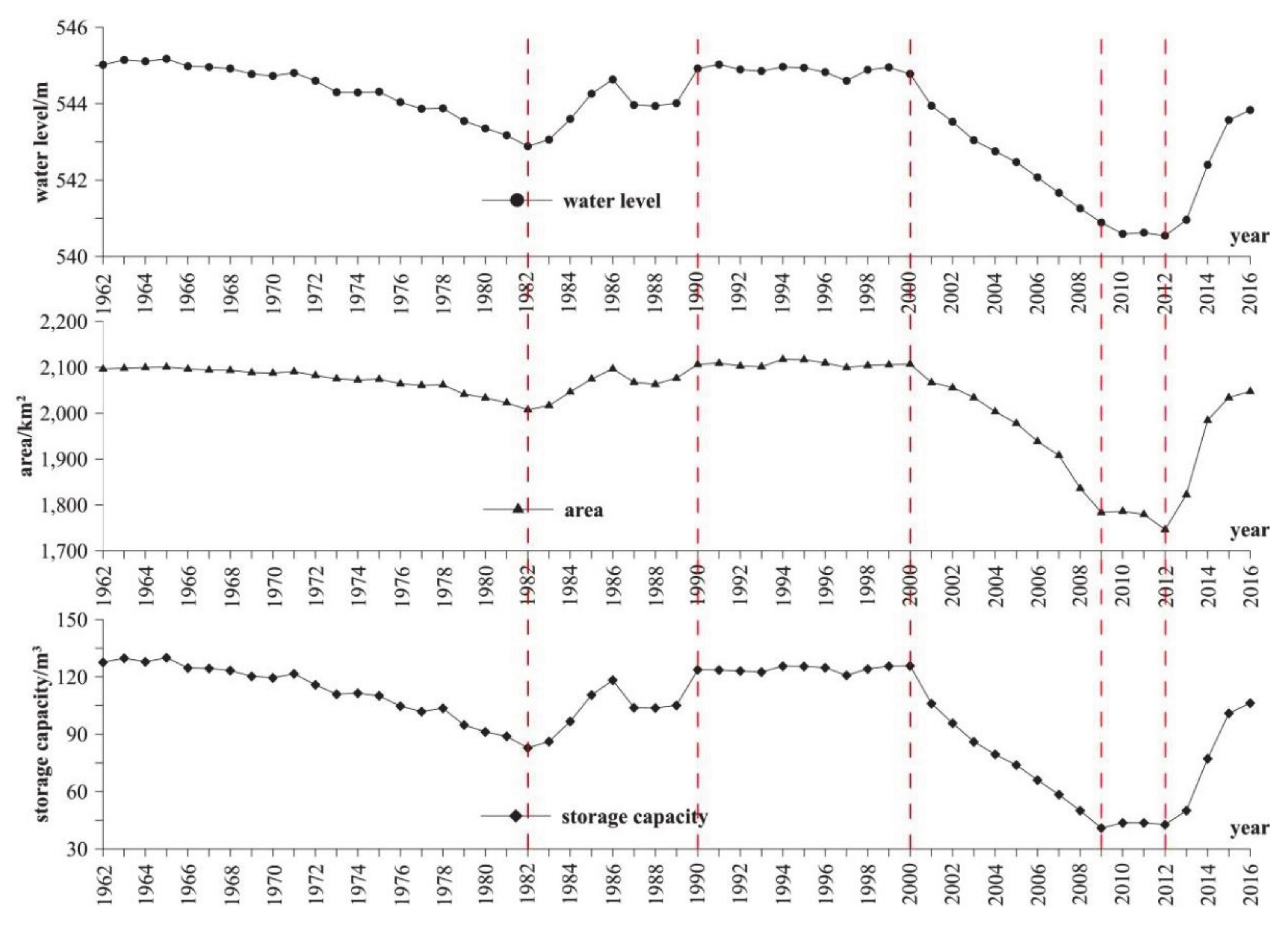
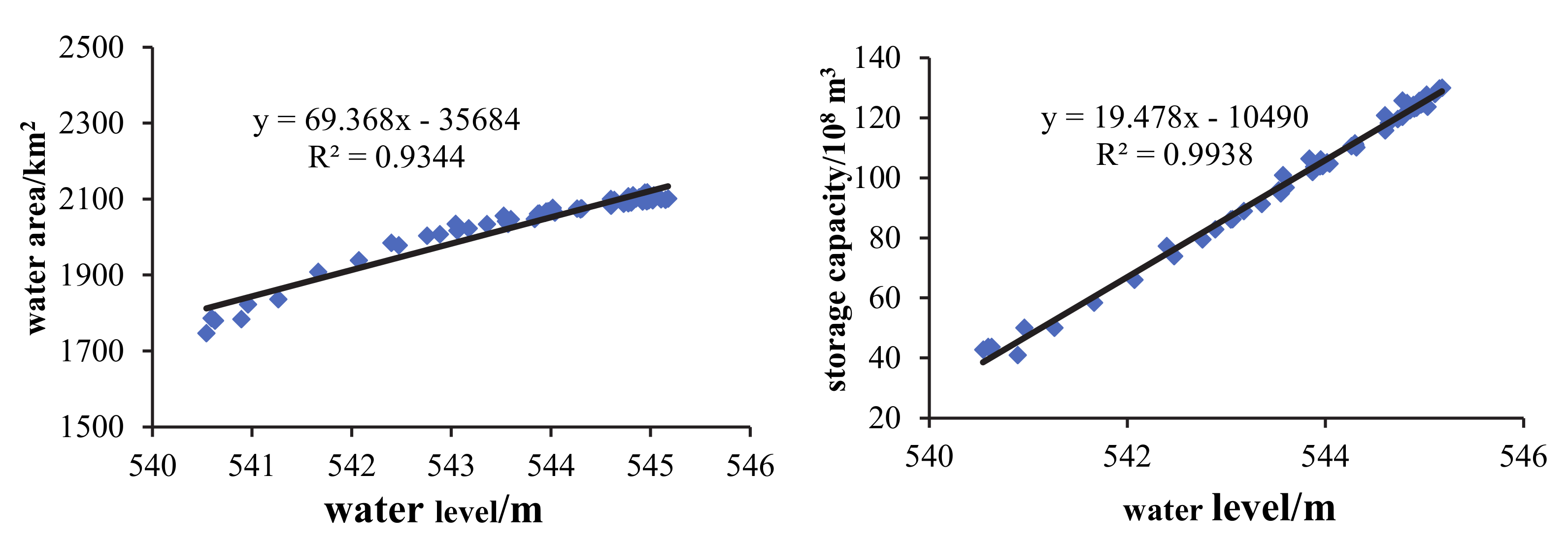
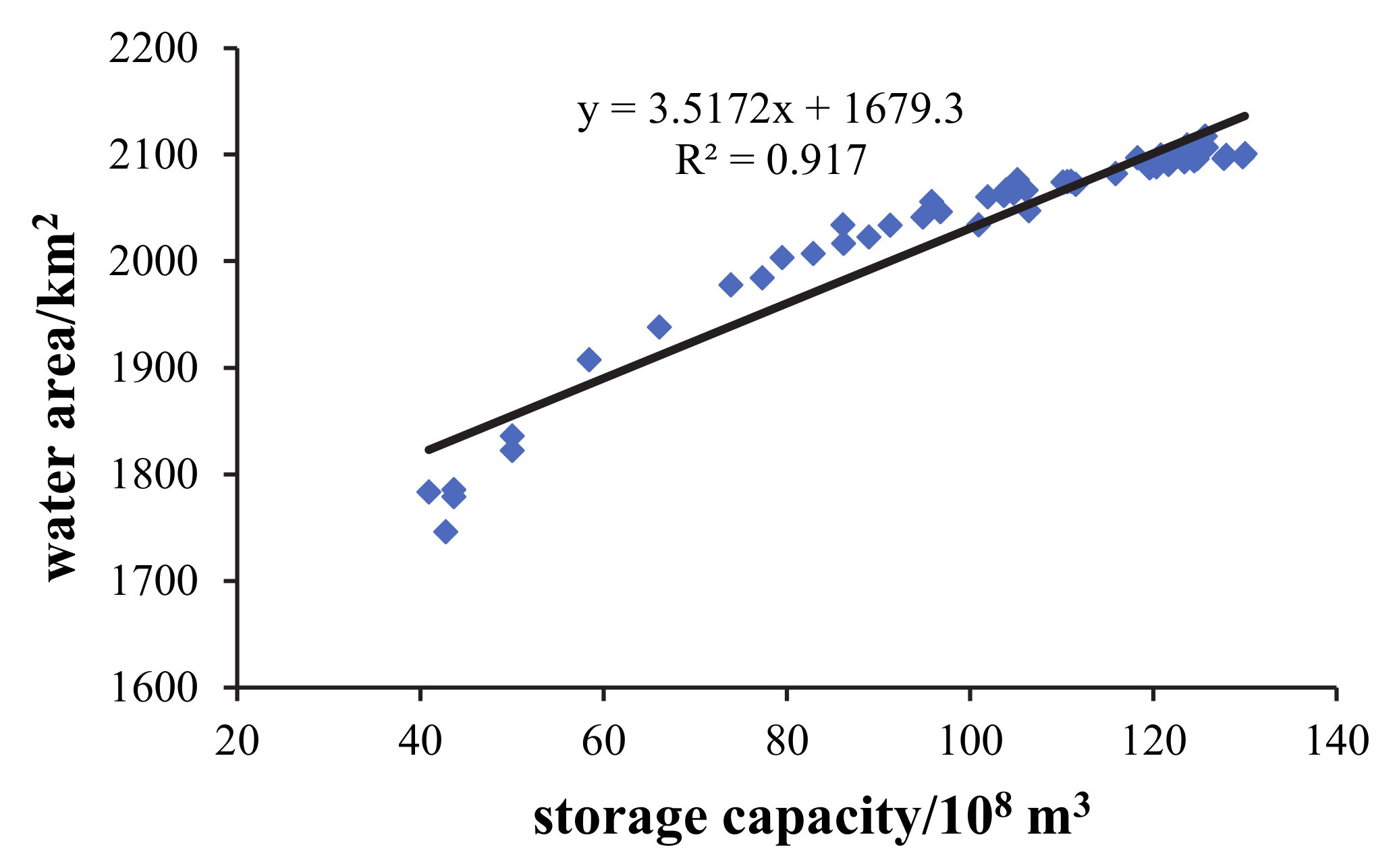
4.1.1. Annual Variations in Hulun Lake

The surface area and reservoir capacity of Hulun Lake under different water levels can be calculated with a three-dimensional model of the lake basin established by Sun Biao using the elevation of the lake bottom projected by the retrieval model of water depth and the actual topography of the lake bottom [44]. The relationship between the water surface area and reservoir capacity, and water level of the Hulun Lake can be expressed as:
V = 0.778H2 − 824.896H + 218588.883,
A = 228.3H − 121992,
where: V denotes the reservoir capacity of the lake (108 m3), A represents the area of the lake (km2), and H is the water level of the lake (m).
Figure 2 shows the changes in the area, water level, and reservoir capacity of Hulun Lake in recent years. From 1962–2016, the variation trend of the water level of the Hulun Lake, area, and reservoir capacity was consistent and can be generally divided into six phases. From 1962–1982, the water level of Hulun Lake exhibited a slowly decreasing trend. In 1965, the maximum water level, lake area, and reservoir capacity were 545.21 m, 2110 km2, and 13.47 billion m3, respectively. During this period, the lowest water level was 542.92 m, and the corresponding lake area and reservoir capacity were 2022.37 km2 and 8.722 billion m3, respectively. From 1982–1990, the Hulun Lake volume exhibited a fluctuating increasing-decreasing-increasing trend. From 1990–2000, the water level of the lake remained high. In 2000, the maximum water level was 544.8 m, and the corresponding reservoir capacity was 12.58 billion m3, which peaked during the last 20 years. From 2000–2009, the lake volume exhibited a rapidly decreasing trend. In 2009, the water level, area, and reservoir capacity were 540.5 m, 1775.7 km2, and <4.1 billion m3, respectively. The volume decreased by about two-thirds, and the maximum water depth was <4 m. From 2009–2012, the water level of Hulun Lake stopped decreasing and was stable. From 2012–2016, the water level of Hulun Lake experienced rapid recovery.

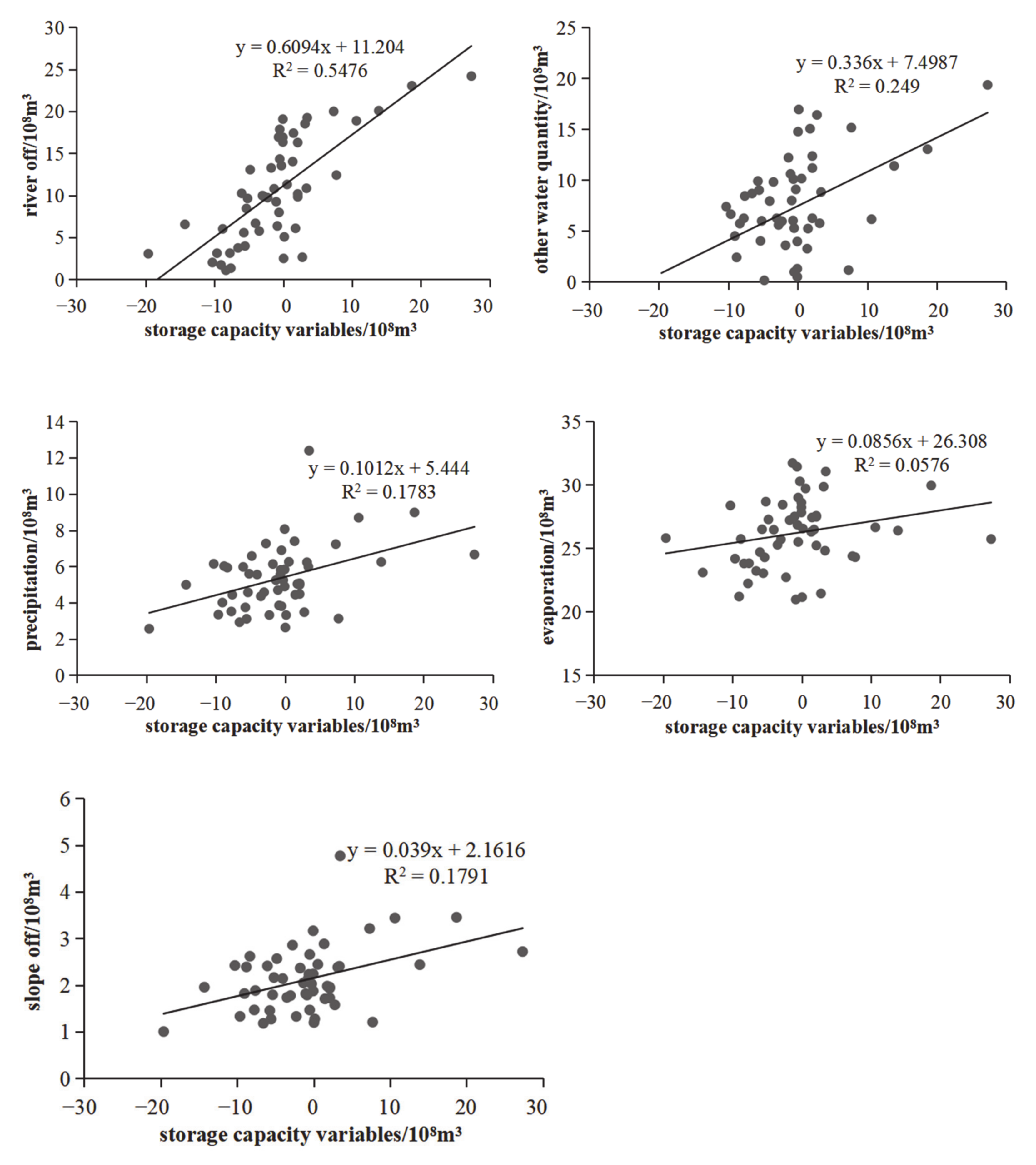
4.1.2. Analysis of the Driving Forces of Changes in Hulun Lake
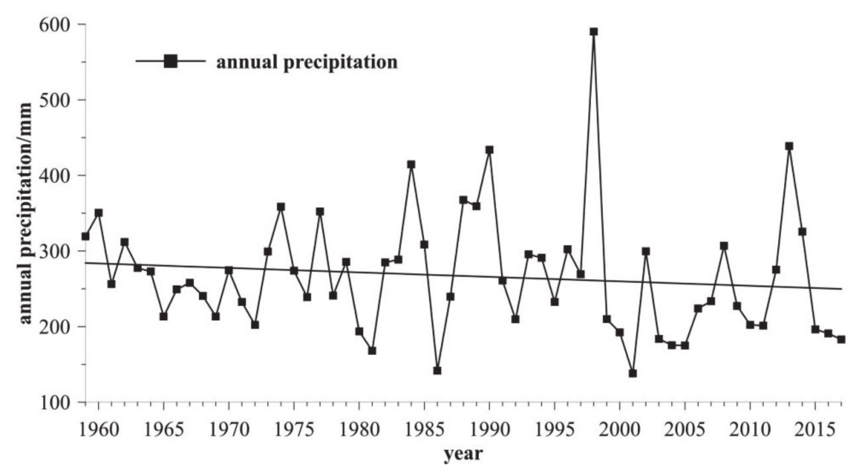
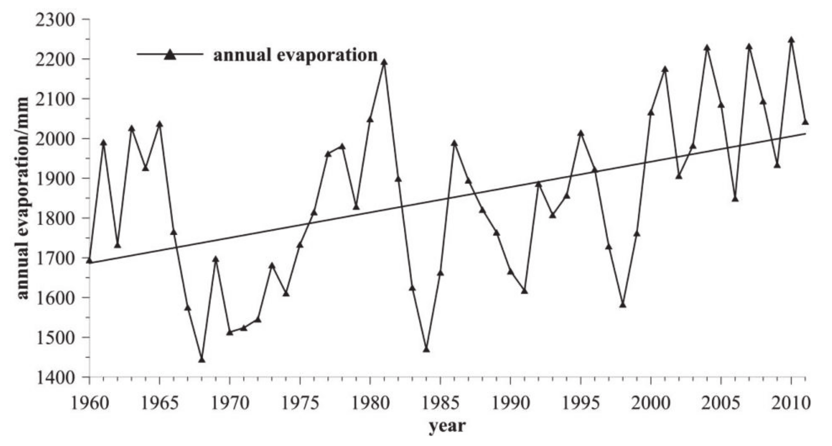
Climatic Factors

Analysis of the temperature data for the last 50 years (Figure 3) revealed that the annual mean temperature of Hulun Lake was 0.26 °C, and the temperature exhibited a significant increasing trend. The mean temperatures in the 1960s, 1970s, 1980s, 1990s, and after 2000 were −0.55 °C, −0.39 °C, −0.18 °C, 1.06 °C, and 1.26 °C, respectively. After 1987, the temperature suddenly changed and rapidly increased. After the 1990s, the rate of temperature rise further increased.
The analysis of the precipitation data for the last 50 years (Figure 4) revealed that the annual mean precipitation in the Hulun Lake area was 261.1 m, and the annual mean precipitation exhibited a decreasing trend. The period of 1960–1981 was arid, with little rain. In 1982–1998, Hulun Lake entered a wet and rainy period. The period of 1999–2011 was extremely arid, with little rain and a peak in 1998. After 1998, the precipitation decreased drastically from 590 mm to 177 mm, and the rate of decrease in the water level accelerated.
The results of this study (Figure 5) indicated that the evaporation of Hulun Lake was affected by the wind direction and melting ice. The west and south wind had the highest and lowest evaporation, respectively. The lowest evaporation was observed from April to May. In mid-May, the lake disappeared, and a drastic increase in evaporation occurred. The annual evaporation of Hulun Lake exhibited an increasing trend from 1960–2011, which peaked at the end of 1980. Currently, the evaporation is in the peak region of the curve.

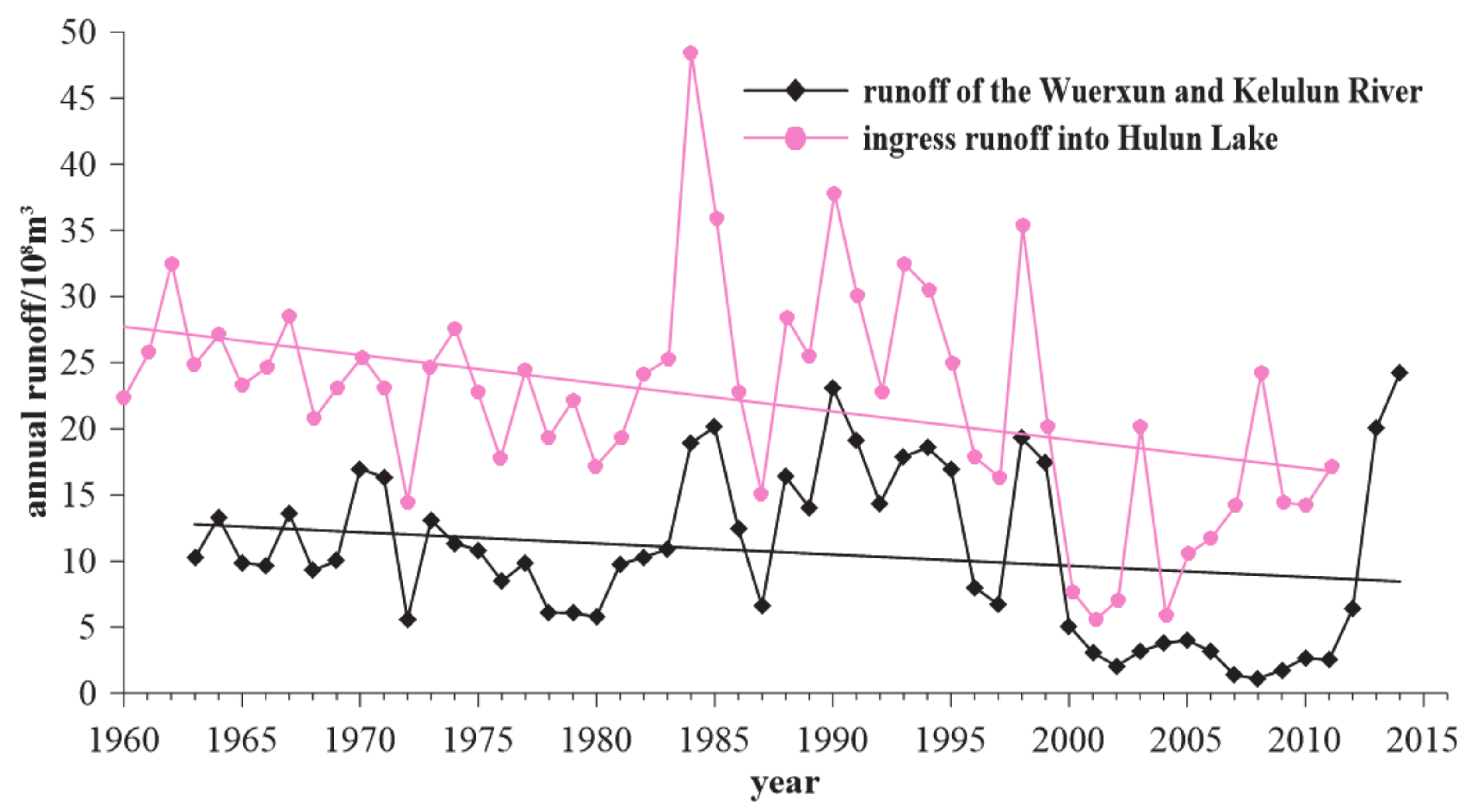
Ingress Runoff Volume
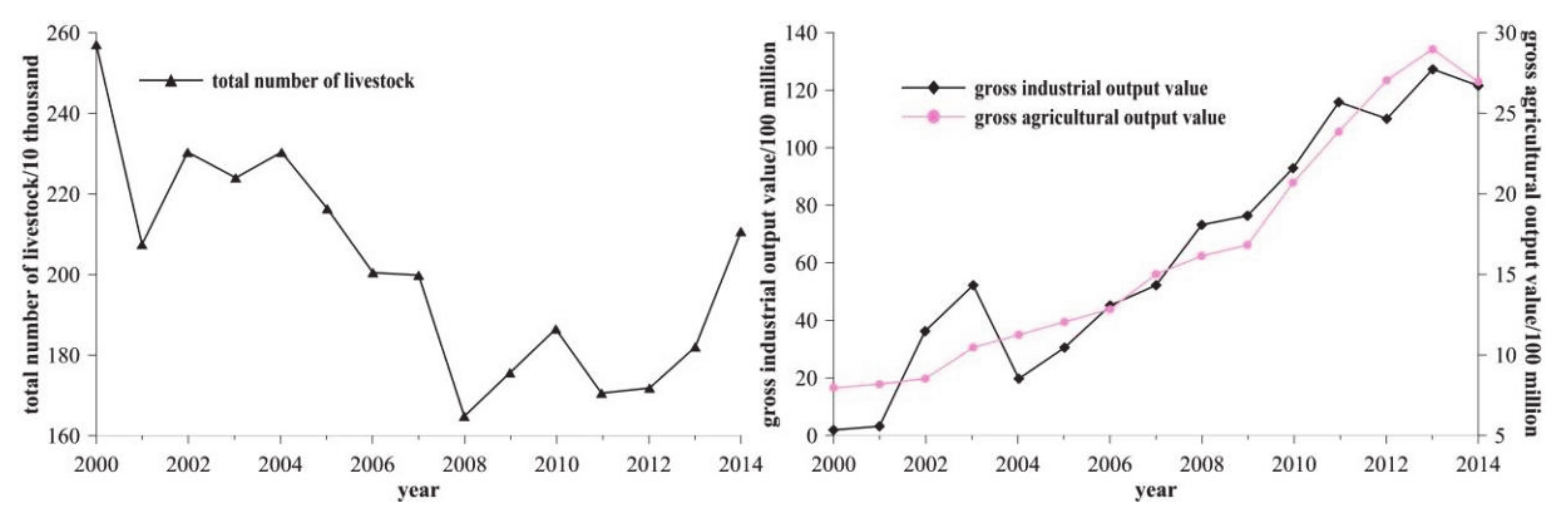
The water sources of Hulun Lake are the Wuerxun River, Kelulun River, and the surrounding 5000 km2 water catchment area [45]. Based on the annual ingress runoff volume variation curve for Hulun Lake (Figure 6), we found that the annual ingress runoff volume from 1960–2011 exhibited a decreasing trend, which worsened after the 1980s. The runoff volume of the Wuerxun and Kelulun Rivers decreased sharply after 1995. From 2011–2014, the runoff volume of these two rivers recovered to a higher value.

Human Factors

Studies on the driving factors of dynamic changes in lakes in semi-arid regions have attracted widespread attention from researchers. Shenglit et al. [6] analyzed the relationship between the quantity, area, and natural (temperature, precipitation, and evaporation) and social (animal husbandry, coal mining, and agriculture) factors of lakes in Inner Mongolia and found that the changes in the lakes in Inner Mongolia were mainly affected by human activities, particularly coal mining.
The water for domestic usage in Manzholi, New Barag Right Banner, and New Barag Left Banner around Hulun Lake are partially obtained from Hulun Lake. After 2000, the area around Hulun Lake underwent rapid economic development. In 2003–2013, the gross domestic product (GDP) increased by more than eight folds, the proportion of secondary industries reached >50%, and industry became the main source of economic growth in this region [46]. Coal mining accounted for >10% of the secondary industry, and Manzhouli to the north of Hulun Lake was one of the three coal mining regions in Hulun Buir [47]. According to the industrial output data analyzed in this study (Figure 7), the total industrial output of the Hulun Lake area increased by 81 folds in 2014. With the rapid growth of secondary industries, the amount of coal mined also increased rapidly, directly resulting in a decrease in the groundwater level [48] and ultimately reduced groundwater recharge. The primary industry output also increased with the overall increase in economic development, but the proportion of the primary industry relative to the total industry significantly decreased [46]. In addition, the agricultural output data used in this study indirectly reflects an increase in cultivated land area. The increase in the area of cultivated land and the number of livestock directly led to increased water consumption, land desertification, and severe vegetation degradation. Moreover, they resulted in some damage to the ecological environment of the Hulun Lake wetlands [36].
In summary, the increased temperature decreased precipitation, and increased evaporation resulted in decreased river discharge into the lake and increased water consumption from Hulun Lake. These were the main reasons for the decrease in the water level and area of Hulun Lake. The main effects of the natural and social factors, such as the number of livestock, agricultural output, and industrial output, resulted in drastic changes in the water level and area of Hulun Lake.

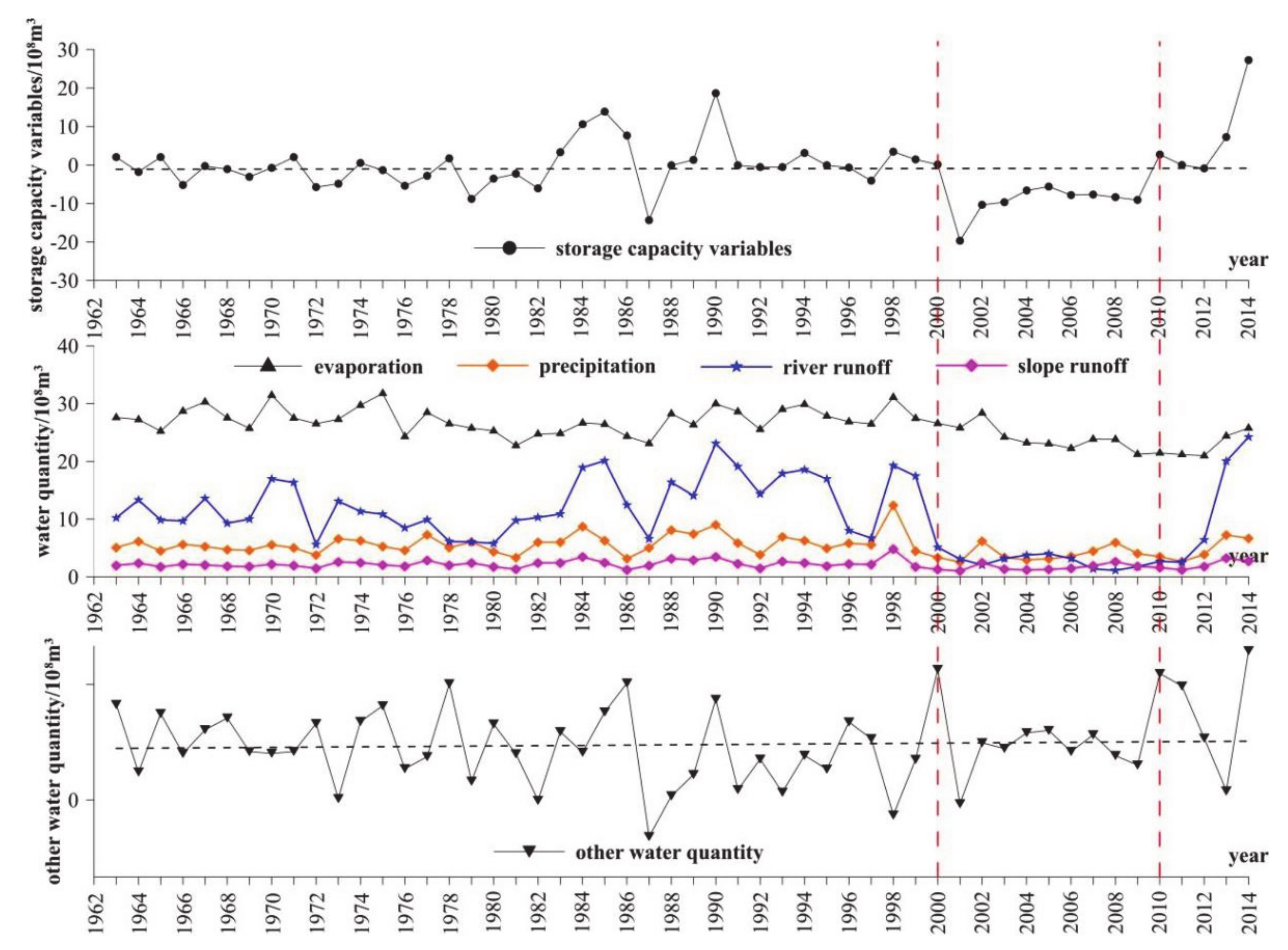
4.2. Analysis of the Water Balance of Hulun Lake

To better analyze the hydrological characteristics of Hulun Lake, reveal the dynamic evolution patterns of water volume, and ultimately provide a basis for lake conservation, governance, and planning of drainage basin water resources, we carried out a water balance analysis for Hulun Lake based on data collected from Hulun Lake during the last 55 years. The derived water balance equation is:
ΔV = QP + QR-in + Qoverland − QE + Qother,
where ΔV is the storage variable of Hulun Lake within a period of time, i.e., the difference in the reservoir capacity; QP is the atmospheric precipitation received by the surface of Hulun Lake within a period of time; QR-in is the total runoff volume entering Hulun Lake within a period of time; Qoverland is the volume of the slope confluence that directly enters Hulun Lake within a period of time; QE is the evaporation of Hulun Lake within a period of time; and Qother is the volume of other residual water of Hulun Lake within a period of time.
With the exception of Qother, which is unknown, the other five variables could be obtained from existing data for the study site, and the variations in Qother could be ultimately derived.
Equation (5) was used to calculate the water balance of Hulun Lake. Figure 8 shows the variation trends of the various parameters after the calculations. ΔV is the difference in the reservoir capacity, representing the dynamic change in lake water volume. A positive value indicates that the total lake volume increased compared to the previous year’s, and a negative value indicates that the total lake volume decreased. The changes in the reservoir capacity difference also reflect the health status of the lake.
The results revealed that from 1962–2000, the reservoir capacity difference fluctuated between positive and negative values and between increasing and decreasing trends, and it was in a healthy state. From 2000–2009, the reservoir capacity difference was continuously negative, reflecting an unhealthy continuous shrinkage state. The rainfall and evaporation from the lake’s surface and the slope confluence that directly entered the lake fluctuated throughout several years, and their annual mean values were 535 million m3, 2.622 billion m3, and 212 million m3, respectively. The river runoff volume fluctuated from 1962–2000, and the mean annual runoff volume was 1.263 billion m3. From 2001–2009, the runoff volume drastically decreased, with a mean annual runoff volume of 286 million m3 (77.4% reduction). In 2010, the runoff volume exhibited a drastically increasing trend. Based on the other variables obtained from the water balance model, except for years with negative values, the mean value in the other years was 792 million m3. The positive/negative Qother value indicates whether the amount of water entering the lake (i.e., the groundwater recharge volume) is greater than or less than the amount of water leaving the lake (i.e., the discharge volume and seepage volume). After deducting the seepage and surface discharge, we found that groundwater recharge into Hulun Lake annually is 792 million m3.

4.3. Examination of the Ecological Water Demand of Hulun Lake

4.3.1. Minimum Ecological Water Demand of Hulun Lake

The calculation of the ecological water demand of lake wetlands mainly involves the use of water balance, water exchange cycle, minimum water level, functional, habitat, and remote sensing methods [49]. In this study, the functional method was used to calculate the ecological water demand of Hulun Lake. The functional method mainly considers the environmental, ecological, and production functions of the lake. For Hulun Lake, the prevention of lake salinization is the main method of maintaining the basic environmental functions of the lake. There are historical records of Hulun Lake transitioning from a freshwater lake to a saltwater lake based on the salt content; hence, the salt content of Hulun Lake was mainly chosen to represent the environmental functions. The main ecological function is the protection of the rare birds and fishes in Hulun Lake and the provision of hydrologic conditions for the habitats of these animals. The functions of Hulun Lake also include the production of the water required for the nature reserve, Jalainur coal mining, and domestic use.
Based on the results of previous studies [50], a salt content of 1000 mg/L is the cutoff point between a freshwater lake and a brackish lake, a salt content of 3500 mg/L is the boundary between a brackish lake and a saltwater lake, and a salt content of 5000 mg/L is the boundary between a saltwater lake and a salt lake. To ensure the environmental function of the lake and prevent lake salinization, the salt content of the lake should be <1000 mg/L. Figure 9 shows the changes in the salt content and water level of Hulun Lake from 1961 to 2009.
As can be seen from Figure 9, when the salt content was high, the corresponding water level was low, and these two variables exhibited a good correlation, which is related to the characteristics of Hulun Lake. The changes in the salt content of Hulun Lake were mainly controlled by an increase or decrease in the water volume. When the lake volume and water level increased, the lake became a drainage lake, and the salt content decreased to <1000 mg/L, this made it a freshwater lake. When the lake volume and water level decreased, and the drainage ceased, the lake became an inland lake, and the salt content increased to >1000 mg/L; this made it a brackish lake. When the salt content was <1000 mg/L, the water level was >544.33 m, and when the water level was <544.33 m, the salt content was >1000 mg/L.
The water level, area, and volume of Hulun Lake are highly correlated (Figure 10); hence, the corresponding lake area and volume could be calculated using the water level. The equations for calculating these two variables are as follows:
Water body area: y = 69.368x − 35684, R2 = 0.9344.
Reservoir capacity: y = 19.478x − 10490, R2 = 0.9938.
At a water level of 544.33 m, the area and volume of the lake were 2075.08 km2 and 11.246 billion m3, respectively. Therefore, for Hulun Lake, the minimum ecological water demand should be 11.246 billion m3 to ensure that the salt content of the lake is within the range for freshwater lakes, that is, to satisfy the ecological functions of the lake.
Regarding the production functions, we mainly considered the Jalainur coal mining and domestic water. Based on the records obtained from the Jalainur Mine Bureau water pump station, 26.04 million m3 must be pumped from Hulun Lake to satisfy the water consumption of the bureau, and the minimum ecological water demand of Hulun Lake is 11.272 billion m3.

4.3.2. Minimum Water Body Area of Hulun Lake

Figure 11 shows that the area and volume of Hulun Lake are highly correlated. Therefore, the lake volume could be used to calculate the lake area; that is, the minimum ecological water demand of the lake can be converted to the lake area.
Y = 3.5172x + 1679.3, R2 = 0.917.
From this equation, it can be seen that when the minimum ecological water demand of Hulun Lake is 11.272 billion m3, the corresponding ecologically secure lake area is 2075.76 km2. When the lake area is >2075.76 km2, Hulun Lake becomes a freshwater lake and its water volume can satisfy the ecological water demand of the lake. When the lake area is <2075.76 km2, the water volume of Hulun Lake cannot satisfy the minimum ecological water demand of the lake.

5. Discussion

In order to further analyze the causes of the evolution of Hulun Lake, we carried out a correlation analysis of the other variables in the water balance equation (Equation (5)). The reservoir capacity difference ΔV and the variables with the highest correlation were the major factors affecting the area and water level of the lake. The results of the correlation analysis (Figure 12) indicate that the river runoff volume (QR-in) had the highest correlation with the reservoir capacity difference (R2 = 0.5476). The precipitation (QP), evaporation (QE), slope runoff (Qoverland), and other residual water (Qother) did not exhibit significant correlations (R2 = 0.1783, 0.0576, 0.1791, and 0.249, respectively). Based on this, the water level of Hulun Lake continuously decreased from 2000–2009. The main reason for the continuous decrease in the lake area was the decrease in the river runoff volume; that is, the volume of water supplied by the Kelulun River and Wuerxun River decreased. From 2009–2016, the lake stopped shrinking and started recovering as the volume of water supplied by these two rivers recovered to a higher value. The volume of the water in these two rivers determined the rise and fall in the water level of Hulun Lake. As the Kelulun River and Wuerxun River are both international rivers and their headwaters are mainly in Mongolia, there is no reasonable explanation for the causes of the sudden changes in the runoff volume at the moment, and a global drainage basin survey needs to be conducted to obtain reliable information.
Previous studies [44,51] have reported that the Kelulun River and Wuerxun River accounted for half of the runoff volume entering Hulun Lake and were the main water sources for Hulun Lake. In order to satisfy the minimum ecological water demand of Hulun Lake, the Kelulun River and Wuerxun River must supply half of the minimum ecological water demand; that is, the annual combined runoff volume of the two rivers should be 5.5 billion m3. In reality, these two rivers cannot meet the minimum ecological water demand of the lake; the mean ingress volume was 1.06 billion m3 for many years and 2–3 billion m3 in the last few years. Therefore, artificial water diversion rational grassland and irrigation planning, and beneficial human activities are required to satisfy the minimum ecological water demand of the lake.

6. Conclusions

(1)
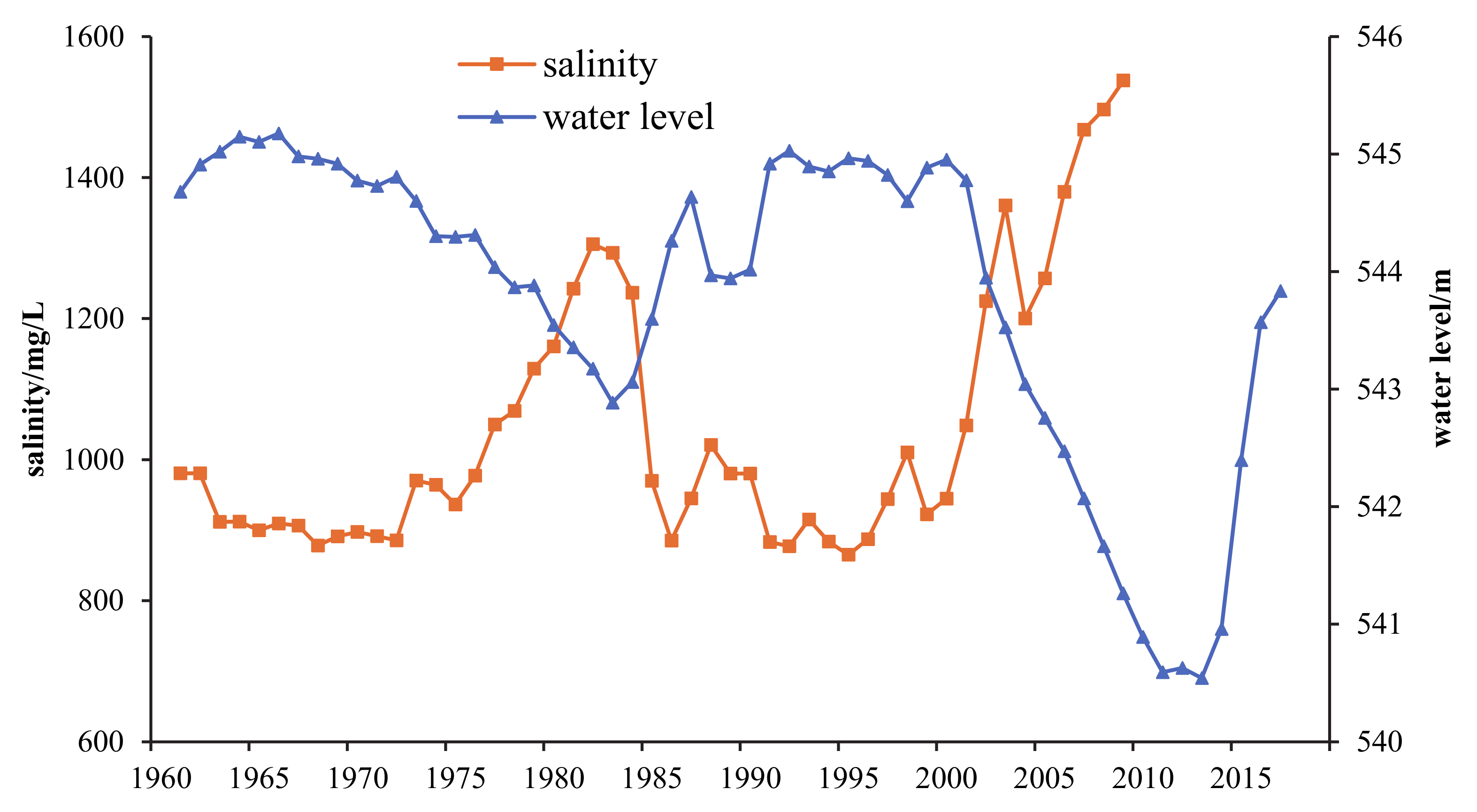
In the past 55 years, the changes in the water level, area, and reservoir capacity of Hulun Lake have been consistent and can be roughly divided into six stages: In 1962–1982, the water level of Hulun Lake exhibited a slow decline; From 1982–1990, the water volume of Hulun Lake showed a fluctuating trend of growth–decline–growth; From 1990–2000, Hulun Lake maintained a high water level; From 2000–2009, the water volume of Hulun Lake showed a rapidly decreasing trend; From 2009–2012, the water level of Hulun Lake ceased to decrease and was basically in a stable state; and from 2012–2016, the water volume of Hulun Lake exhibited a rapid recovery.
(2)
The dynamic changes in the water level and water body area of Hulun Lake are the interplay of climate change and human activities. The increase in temperature and evaporation, and the decrease in precipitation lead to a decrease in the amount of water entering the lake from the main recharge rivers in the region, which is the primary reason for the decrease in the water level and water body area of Hulun Lake.
(3)
According to the results of the water balance analysis of Hulun Lake for a long time series, groundwater occupies a certain proportion of the water cycle of Hulun Lake, and approximately 792 million m3 of groundwater is recharged to the lake every year after deducting seepage and surface discharge.
(4)
Based on the theory of ecological water demand of the lake and the actual situation of Hulun Lake, the ecological water demand of Hulun Lake was investigated, and the minimum ecological water demand of Hulun Lake was 11.272 billion m3, considering the environmental, ecological, and production functions of Hulun Lake.

Author Contributions

Methodology, Y.Z.; validation, L.W. and W.W.; formal analysis, J.G.; investigation, L.W.; resources, X.S.; data curation, B.S.; writing—original draft preparation, J.G. and B.S.; writing—review and editing, W.W.; visualization, X.S.; supervision, Y.Z.; project administration, J.G. and W.W.; funding acquisition, J.G. All authors have read and agreed to the published version of the manuscript.

Funding

This study was financially supported by the Basic Scientific Research Project (Grant No. SK201903), National Key Research and Development Subject (Grant No. 2019YFC0409201), China Engineering Science and Technology Knowledge Center Construction Project (Grant No. CKCEST-2022-1-16) and China Geological Survey Project (Grant No. DD20190433).

Institutional Review Board Statement

Not applicable.

Informed Consent Statement

Not applicable.

Data Availability Statement

The data presented in this study are available on request from the corresponding author.

Acknowledgments

We would like to thank Jiansheng Shi from Aero Geophysical Survey and Remote Sensing Center for Natural Resources, China Geological Survey for technical support. We would like to thank LetPub and Editage (www.editage.cn accessed on 2 October 2022) for their linguistic assistance in preparing this manuscript.

Conflicts of Interest

The authors declare no conflict of interest.

References

  1. Huang, Q.C. Function Evolution and Its Driving Force Analysis of the Structure of Inland Wetland—A Case of Honghu Wetland. Master’s Thesis, Central China Normal University, Wuhan, China, 2013. [Google Scholar]
  2. Zhao, S.; Ji, W.Q.; Gao, P.; Han, W.J.; Xu, D.W. Study on dynamic change of Hulun lake water area and the relationship with the climatic factors during 1986~2016. Chin. J. Agric. Resour. Reg. Plan. 2018, 39, 53–58. [Google Scholar]
  3. Hu, R.J.; Jiang, F.Q.; Wang, Y.J.; Sun, Z.D.; Li, Y. On the importance of research on the lakes in arid land of China. Arid. Zone Res. 2007, 24, 137–140. [Google Scholar]
  4. Han, Z.M. Study on Hydrogen and Oxygen Isotope and Hydrochemistry Characteristics of Hulun Lake Basin. Master’s Thesis, Inner Mongolia Agricultural University, Hohhot, China, 2018. [Google Scholar]
  5. Ding, Y.J.; Liu, S.Y.; Ye, B.S.; Zhao, L. Climatic implications on variations of lakes in the cold and arid regions of China during the recent 50 years. J. Glaciol. Geogryol. 2006, 28, 623–632. [Google Scholar]
  6. Tao, S.L.; Fang, J.Y.; Zhao, X.; Zhao, S.Q.; Shen, H.H.; Hu, H.F.; Tang, Z.Y.; Wang, Z.H.; Guo, Q.H. Rapid loss of lakes on the Mongolian Plateau. Proc. Natl. Acad. Sci. USA 2015, 112, 2281–2286. [Google Scholar] [PubMed] [Green Version]
  7. Yang, G.S.; Ma, R.H.; Zhang, L.; Jiang, J.H.; Yao, S.C.; Zhang, M.; Zeng, H.A. Lake status, major problem and protection strategy in China. J. Lake Sci. 2010, 22, 799–810. [Google Scholar]
  8. Russell, J.M.; Werne, J.P. Climate change and productivity variations recorded by sedimentary sulfur in Lake Edward, Uganda/D. R. Congo. Chem. Geol. 2009, 264, 337–346. [Google Scholar] [CrossRef]
  9. Smith, R.; Kalff, J. Limnology: Inland water ecosystems. J. N. Am. Benthol. Soc. 2002, 21, 346–347. [Google Scholar] [CrossRef]
  10. Park, J.; Byrne, R.; Böhnel, H.; Garza, R.M.; Conserva, M. Holocene climate change and human impact, central Mexico: A record based on maar lake pollen and sediment chemistry. Quat. Sci. Rev. 2010, 29, 618–632. [Google Scholar] [CrossRef]
  11. Birkett, C.M. Synergistic remote sensing of Lake Chad: Variability of basin inundation. Remote Sens. Environ. 2000, 72, 218–236. [Google Scholar] [CrossRef]
  12. Bai, A.J.; Jia, L.; Xu, W.X. Evaporation and its impact upon drought climate around the Qinghai Lake Basin based on potential Evaporation. Arid. Land Geogr. 2011, 34, 949–957. [Google Scholar]
  13. Zhang, Y.Y.; Cai, X.B.; Yang, C.; Song, X.X.; Li, R.D.; Li, E.H.; Wang, X.L. Driving force analysis of landscape pattern changes in Honghu Wetland Nature Reserve in recent 40 years. J. Lake Sci. 2019, 31, 171–182. [Google Scholar]
  14. Liu, H.J.; Liu, E.F.; Yu, Z.Z.; Zhang, E.L.; Lin, Q.; Wang, R.; Shen, J. Spatio-temporal patterns of organic carbon burial in the sediment of Lake Erhai in China during the past 100 years. J. Lake Sci. 2019, 31, 282–292. [Google Scholar]
  15. Wurtsbaugh, W.A.; Miller, C.; Null, S.E.; DeRose, R.J.; Wilcock, P.; Hahnenberger, M.; Howe, F.; Moore, J. Decline of the world’s saline lakes. Nat. Geosci. 2017, 10, 816. [Google Scholar]
  16. Meng, Q.M. Climate change and extreme weather drive the declines of saline lakes: A showcase of the Great Salt Lake. Climate 2019, 7, 19. [Google Scholar] [CrossRef] [Green Version]
  17. Budzyńska, A.; Rosińska, J.; Pełechata, A.; Toporowska, M.; Krzebietke, A.N.; Kozak, A.; Messyasz, B.; Pęczuła, W.; Kokociński, M.; Wasielewska, E.S.; et al. Environmental factors driving the occurrence of the invasive cyanobacterium Sphaerospermopsis aphanizomenoides (Nostocales) in temperate lakes. Sci. Total Environ. 2019, 650, 1338–1347. [Google Scholar] [CrossRef]
  18. Ahmed, M.H.; El Leithy, B.M.; Thompson, J.R.; Flower, R.J.; Ramdani, M.; Ayache, F.; Hassan, S.M. Application of remote sensing to site characterisation and environmental change analysis of North African coastal lagoons. Hydrobiologia 2009, 622, 147–171. [Google Scholar] [CrossRef]
  19. Armentrout, G.W.; Wilson, J.F. An Assessment of Low Flows in Streams in Northeastern Wyoming; US Geological Survey: Reston, VA, USA, 1987. [Google Scholar]
  20. Henry, C.P.; Amoros, C. Restoration ecology of riverine wetlands: Ⅰ. a scientific base. Environ. Manag. 1995, 19, 891–902. [Google Scholar]
  21. Petts, G.E. Water allocation to protect river ecosystems. Regul. Rivers Res. Manag. 1996, 12, 353–365. [Google Scholar]
  22. Gleick, P.H. Water in Crisis: A guide to the Worlds Flesh Water Resources; Oxford University Press: New York, NY, USA, 1993. [Google Scholar]
  23. Gleick, P.H. Water in Crisis: Paths to sustainable water use. Ecol. Appl. 1998, 8, 571. [Google Scholar]
  24. Falkemnakr, M. Coping with water scarcity under rapid population growth. In Proceedings of the Conference of SADC Ministers, Lilongwe, Malawi, 13 May 2022; pp. 23–24. [Google Scholar]
  25. Hughes, D.A.; Ziervogel, G. The inclusion of operating rules in a daily reservoir simulation model to determine ecological reserve releases for river maintenance. Water SA-Pretoria 1998, 24, 293–302. [Google Scholar]
  26. Sun, D.Y.; Hu, X.Q.; Jin, Y.Z.; Zhang, Y.L.; Li, Y.H. Prediction and evaluation of ecological water requirement of natural vegetation in the middle reaches oasis of Shulehe River Basin. Arid. Land Geogr. 2016, 39, 154–161. [Google Scholar]
  27. Hao, B. Study on the Spatial and Temporal Variation of Vegetation Ecological Water Requirement in Shi Yang River Basin Based on GIS and RS. Master’s Thesis, Northwest A & F University, Yangling, China, 2010. [Google Scholar]
  28. Bai, Y.; Xu, H.L.; Zhang, Q.Q.; Ye, M. Evaluation on ecological water requirement in the lower reaches of Tarim River based on groundwater restoration. Acta Ecol. Sin. 2015, 35, 630–640. [Google Scholar]
  29. Jiang, L.L.; Jiao, J.Y.; Wang, X.Y.; Liu, J.; Li, Y. Study on ecological water requirement for the lake and natural vegetation in the Alice Lake basin. J. Arid. Land Resour. Environ. 2016, 30, 108–114. [Google Scholar]
  30. Sun, D.Y.; Yang, J.; Hu, X.Q.; Jin, Y.Z.; Zhang, Y.L. Study on eco-environmental water requirement in the middle-reach oasis of Shulehe River Basin based on ecological protection target. Acta Ecol. Sin. 2017, 37, 1008–1020. [Google Scholar]
  31. Wang, Z.J. The Numerical Simulation of the Hulun Lake Watershed Hydrology in Inner Mongolia under the Future Climate. Ph.D. Thesis, Inner Mongolia Agricultural University, Hohhot, China, 2012. [Google Scholar]
  32. Wang, Z.J.; Li, C.Y.; Li, W.P.; Zhang, S. Calculation and analysis of water balance in Lake Hulun, Inner Mongolia. J. Lake Sci. 2012, 24, 273–281. [Google Scholar]
  33. Li, C.; Ma, W.; Ye, B.S.; Liao, W.G. Estimation of water evaporation and water balance in ungauged Hulun lake. J. China Hydrol. 2006, 26, 41–44. [Google Scholar]
  34. Zhao, H.Y.; Wu, L.J.; Hao, W.J. Influences of climate change to ecological and environmental evolvement in the Hulun Lake wetland and its surrounding areas. Acta Ecol. Sin. 2008, 28, 1064–1071. [Google Scholar]
  35. Yang, H.C.; Jiang, M.Y.; Wang, G.Q.; Wu, B.B. Changes in land use and landscape pattern in Hulun Lake nature reserve. J. Beijing Norm. Univ. 2013, 49, 318–325. [Google Scholar]
  36. Wu, Y.N. Health Assessment and Stability Threshold Analysis of the Hulun Lake Ecosystem Using Remote Sensing. Master’s Thesis, China Institute of Water Resources and Hydropower Research, Beijing, China, 2013. [Google Scholar]
  37. Han, X.H.; Yang, C. An analysis of the self-purification function of Hulun Lake and its effect on regional environmental conservation. J. Nat. Resour. 2002, 17, 684–690. [Google Scholar]
  38. Zhang, H.R.; Qing, H.; Liu, H.M.; Zhuo, Y.; Wen, L.; Liu, D.W.; Li, Z.Y.; Wang, L.X. Dynamics and its driving forces of Hulun lake. J. Inn. Mong. Univ. 2018, 49, 102–107. [Google Scholar]
  39. Han, Z.M.; Shi, X.H.; Jia, K.L.; Sun, B.; Zhao, S.N.; Fu, C.X. Determining the discharge and recharge relationships between lake and groundwater in Lake Hulun using hydrogen and oxygen isotopes and chloride ions. Water 2019, 11, 264. [Google Scholar] [CrossRef]
  40. Li, C.; Ma, W.; Shi, X.X.; Liao, W.G. Reconstruction of the hydrology series and simulation of salinity in ungauged Lake Hulun. J. Lake Sci. 2006, 18, 13–20. [Google Scholar]
  41. Gu, R.Y.; Li, S.H.; Zhao, H.Y.; Li, C.; Song, W.S.; Meng, J.; Wang, Y.P. Responses of runoff in Hulun Lake basin of Inner Mongolia to climate change. Chin. J. Ecol. 2012, 31, 1517–1524. [Google Scholar]
  42. Troin, M.; Vallet-Coulomb, C.; Sylvestre, F.; Piovano, E. Hydrological modelling of a closed lake (Laguna Mar Chiquita, Argentina) in the context of 20th century climatic changes. J. Hydrolody 2010, 393, 233–244. [Google Scholar]
  43. Wang, N. Ecological Water Demand Calculation of Wetland Based on Sensitive Protection Target—A Case Study of Zhalong National Nature Reserve. Master’s Thesis, Hebei University of Engineering, Handan, China, 2020. [Google Scholar]
  44. Sun, B. The Dynamic Change of Water Based on Spatial Information Technology for Hulun Lake in Inner Mongolia. Ph.D. Thesis, Inner Mongolia Agricultural University, Hohhot, China, 2010. [Google Scholar]
  45. Wang, J.J.; Li, C.Y.; Sun, B.; Fan, C.R.; Liang, L.E.; Han, Z.M. Impacts of precipitation on runoff yield of Hulun lake basin during 1963–2014. Bull. Soil Water Conserv. 2017, 37, 115–119. [Google Scholar]
  46. Li, X.F.; Chen, A.R. Correlation analysis of energy intensity and industrial structure in Hulunbuir city. J. Hulunbeier Coll. 2015, 23, 67–69+116. [Google Scholar]
  47. Liu, Z.D. Analysis of industrial and economic situation in Hulunbuir under the new ordinary state. Inn. Mong. Stat. 2015, 2, 63–65. [Google Scholar]
  48. Chen, X. Research progress on the environment impacts from underground coal mining in arid western area of China. China Sci. Technol. Rev. 2015, 16, 358. [Google Scholar]
  49. Cui, B.S.; Yang, Z.F. Water consumption for eco-environmental aspect on wetlands. Acta Sci. Circumstantiae 2002, 22, 31–36. [Google Scholar]
  50. Jiang, J.H.; Huang, Q. Analysis on utilization of the lacustrine water resources and the salinization of lacustring water in west China. Arid. Land Geogr. 2004, 27, 300–304. [Google Scholar]
  51. Guo, J.Y. Research on Water Quality Prediction and Eco-Environmental Water Requirement of the Hulun Lake Inflow Rivers. Master’s Thesis, Inner Mongolia Agricultural University, Hohhot, China, 2016. [Google Scholar]
Figure 1. Geographical location of Hulun Lake.
Water 14 03415 g001
Figure 2. Dynamic changes in Hulun Lake’s water level, area, and reservoir capacity throughout different years.
Water 14 03415 g002
Figure 3. Temperature changes in Hulun Lake drainage basin from 1959–2017.
Water 14 03415 g003
Figure 4. Precipitation changes in Hulun Lake drainage basin from 1959–2017.
Water 14 03415 g004
Figure 5. Evaporation changes in Hulun Lake drainage basin from 1960–2011.
Water 14 03415 g005
Figure 6. Ingress runoff volume changes in Hulun Lake drainage basin from 1960–2011 and runoff volume changes of the Wuerxun and Kelulun River from 1963–2014.
Water 14 03415 g006
Figure 7. Variation trends of social factors from 2000–2014.
Water 14 03415 g007
Figure 8. Water balance variations for Hulun Lake during the last 55 years.
Water 14 03415 g008
Figure 9. Changes in the water level and salt content of Hulun Lake.
Water 14 03415 g009
Figure 10. Correlation analysis of the water level, area, and reservoir capacity of Hulun Lake.
Water 14 03415 g010
Figure 11. Correlation analysis of the area and reservoir capacity of Hulun Lake.
Water 14 03415 g011
Figure 12. Correlation analysis of the reservoir capacity difference in the balance item and other variables.
Water 14 03415 g012
Publisher’s Note: MDPI stays neutral with regard to jurisdictional claims in published maps and institutional affiliations.

